PART III. LOCAL DESCRIPTION OF THE WORKS. (continued 4)
Reading edition
Many of the stones of which the church is built, are Roman, and exhibit reticulated tooling.
KING EDWARD’S MONUMENT.
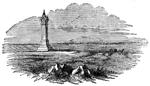
Near to Burgh is the site on which the castle of sir Hugh de Morville, one of the murderers of Thomas à Becket, formerly stood. The adjoining field is called—‘Hang-man-tree,’ doubtless because my lord had his gallows here, always ready for use. A neighbouring enclosure bears a designation not less ominous—‘Spill-blood-holm.’ But the most interesting historical memorial which the neighbourhood of Burgh affords, is the monument to king Edward I., which stands on the marsh.
Longshanks had marshalled his army: his numerous host lay encamped upon the sandy flat on the north of the town: the waters of the Solway alone separated him from the objects of his vengeance. Here the mighty Edward was called to enter into conflict with an enemy whom he had often braved on the battle-field, but who was now to approach him by a new method of assault. In this struggle, his valour availed him nothing, his chivalrous hosts could yield him no aid, and no devoted Eleanor was there to abstract from his veins the subtle poison which the king of terrors had infused. On Burgh-marsh the ‘ruthless king’ breathed his last. A monument, represented in the vignette at the close of this part, marks the spot.
TOWER OF REPENTANCE.
307Another structure, on the opposite side of the Firth, may be noticed by the traveller. The history of the ‘Tower of Repentance’ is strikingly illustrative of the disordered state of society in this district before the union of the two kingdoms.
A chieftain from the northern side having made a successful inroad into the English border, was crossing the Solway on his return, laden with booty, when a sudden storm arose. In order to lighten his labouring vessel, he threw his prisoners overboard in preference to the cattle which he had stolen. The danger past, he was smitten with remorse. In order to make such amends as he could, he built a beacon-tower which overlooks the Solway, and to this day is called the Tower of Repentance. Tradition avers that the penitent himself carried all the stones used in its erection to the top of the hill. It is not far from the town of Ecclefechan.
In passing along the village of Burgh, the observing visitor will notice the large number of boulder-stones, some of them half a ton in weight, which are strewed over the ground; several of them have been used in forming the foundations of the cottages. They are of granite, and in some distant age have been wrenched from the summit of Criffel, the hill which lends so much beauty to the landscape on the northern side of the Solway.
On the western side of the village of Dykesfield, which we next encounter, is a common that contains several earthen ramparts and temporary camps.
Between Dykesfield and the next station, Drumburgh, an extensive marsh occurs, which even now is occasionally overflowed by the waters of the Solway. Hodgson inclines to the belief, that the Wall 308ran directly across it. Horsley, however, took a different view of the subject.
From hence to Drumburgh Castle no vestige of the Wall is to be seen; though I think it certain that the Wall did not pass through the marsh, but by Boustead-hill and Easton, for both tradition and matter of fact favour this course of it. The country people often strike upon the Wall, and could tell exactly several places through which, by this means, they knew it had passed, and always by the side of the marsh. Besides it is no way reasonable to suppose that the Romans would build their Wall within tide-mark.
EASTON-MARSH.
After careful inquiry, I am disposed to adopt Horsley’s view; even now, stones which appear to be Wall-stones, are turned up by the operations of the husbandmen in the line which the Wall is supposed to have taken by Boustead and Easton. It need not be a subject of surprise, that the Wall in this district has been so thoroughly removed, as there is no quarry within a convenient distance, and the Wall, therefore, has been the source from which the inhabitants of the country have drawn their supply of building stones. The Romans seem to have gone to Howrigg quarry, which is not less than eight miles south of the Barrier, for their facing-stones; those which they used for the interior of the Wall correspond in character with the proceeds of Stone-pot-scar, a quarry on the north shore of the Solway.
We must now part company with the Vallum. This wonderful earth-work, which has outlived the accidents of seventeen centuries, and which we have traced, with but few interruptions, from the modern representative of Pons Ælii to this point, is not 309observed going beyond it. As the Vallum falls short of the Wall at its eastern extremity by about four miles, so it does at its western. Horsley, who wrote more than a century ago, and who, consequently, had better opportunities of judging than we can now have, says—
Whether Hadrian’s work (the Vallum) has been continued any further than this marsh, or to the water-side beyond Drumburgh, is doubtful. But I am pretty confident that it was not carried on so far as the Wall of Severus at this end, any more than at the other. And I can by no means yield to Mr. Gordon’s sentiments, that the one, for a good space at each end, was built upon the foundation of the other. However, it is certain that from the side of the marsh to the west end of the Wall there is no appearance of Hadrian’s work, or any thing belonging to it.
DRUMBURGH.
DRUMBURGH contains distinct remains of a small stationary camp. This, if Watch-cross be rejected, was the sixteenth station of the Wall, and consequently, the Axelodunum of the Notitia, which was garrisoned by the first cohort of the Spaniards. The camp is on the grounds of Richard Lawson, esq. The ramparts are well defined, as well as the ditch which surrounds them. The whole area is covered with a luxuriant sward, and its northern margin is shaded by some thriving ash-trees. No portion of the Wall remains in its vicinity, but its present proprietor remembers witnessing the removal of the foundation. The northern rampart of the station did not come up to the Wall, but was removed a few yards from it; probably the military way ran between the station and the Wall. The station at 310Barr-hill, on the Antonine Wall, is similarly situated.
South of the station is a well, enclosed by a circular wall of Roman masonry. It is still in use, though the water is drawn from it by a pump.
The mediæval castle, of which there are considerable remains, is a very fine specimen of the ancient fortified manor-house. It is built of Roman stones. Extensive alterations were made upon it in the reign of Henry VIII. The habitable part of it is now occupied as a farm-house.
The tranquillity of this region was not always what it now is.
Standing on the northern rampart of the station, Mr. Lawson, the aged proprietor, directed the attention of the Pilgrim-party of 1849 to a small cottage on the opposite shore. ‘There,’ said he, ‘lived a Scottish reaver, who in the days of my grandfather made, on nineteen successive Easter-eves, a successful foray on the English side. A twentieth time he prepared to go; his family remonstrated, he however persisted, saying that this should be his last attempt. Our people were prepared for him and slew him.’ Some of the party asked ‘what notice did the law take of the transaction?’ 'None; the law which could not protect a man, would not punish him for taking the law into his own hands.'
Now, nearly arrived at the western extremity of the great Barrier, we meet with but few traces of its characteristic masonry; enough, however, remains to lure us pleasantly to our journey’s end.
In cutting the canal from Carlisle to the Solway Firth, in 1823, a prostrate forest of oak was discovered, which belonged to an age anterior to that of Hadrian. The engineer of the canal says—
PRIMEVAL FOREST.
311A subterraneous forest was cut through in the excavation of the canal, near the banks of the Solway Firth, about half a mile north-west of the village of Glasson, and extending into Kirklands. The trees were all prostrate, and they had fallen, with little deviation, in a northerly direction, or a little eastward of it.—Some short trunks, of two or three feet in height, were in the position of their natural growth; but although the trees, with the exception of their alburnum and all the branches, were perfectly sound, yet the extremity of the trunks, whether fallen or standing, were so rugged, that it was not discoverable whether the trees had been cut down, or had fallen by a violent storm. The level upon which the trunks lay, was a little below that of high tides, and from eight to ten feet below the surface of the ground they were embedded in; which, excepting the superficial soil, is a soft blue clay, having the appearance of marine alluvion.... Although the precise period when this forest fell is not ascertainable, there is a positive proof that it must have been long prior to the building of the Wall because the foundations of the Wall passed obliquely over it, and lay three or four feet above the level of the trees.—Arch. Æl. ii. 117.
The forest extends over a considerable tract of ground. It is probable that it was overthrown by a tempest from the south or south-west, at a time when the sea occupied a lower level than it does at present. The wood was so sound, that it was used in common with other oak timber in forming the jetties at the outlet of the canal into the Solway Firth. The president’s chair of the Society of Antiquaries, Newcastle-upon-Tyne, is formed of it.
At Port-Carlisle is a mound resembling an ancient British barrow, called Fisher’s-cross. About half-a-mile to the westward of it is another which has been somewhat encroached upon by the road that 312runs along the margin of the Solway, and is denominated Knock’s-cross. The proverb is common throughout Cumberland, 'As old as Knock’s-cross.'
In the front of the Steam-packet hotel, Port-Carlisle, is built up the fragment of a small Roman altar, bearing the inscription, SVIS MATRIBVS. It is one of the numerous instances that we meet with, along the line of the Wall, of altars dedicated to the Deæ Matres.
BOWNESS.
Between Port-Carlisle and Bowness, the site of the Wall may be traced nearly the whole way; not unfrequently the foundations of it and its fosse may be discerned. In one place some large stones resembling those used in forming the gateways of the mile-castles will be noticed. In Brand’s day some considerable portions of the Wall remained, between these points. He says—
About three quarters of a mile to the east of Bowness, some fragments of Severus’ Wall remain, of a great height; on measuring one of them, we found it to be about eight feet high; it was bound and overgrown with ivy in a most picturesque manner. The facing-stones on both sides have been taken away.
On my first visit to Bowness, I saw a portion of it as Hodgson describes it—
It is six feet high. Its rugged and weathered core, still hard as a rock, is thickly bearded with sloe-thorn and hazel, and mantled below with ivy and honey-suckle.
This interesting object has been entirely removed, which is the more to be regretted, as no advantage has been gained by its destruction; it served as a fence between two fields.
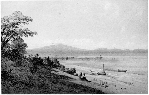
H. Burdon Richardson, Delt.John Storey Lith. BOWNESS.
TERMINATION OF THE WALL.
313BOWNESS is the name of the low, bow-shaped ness, or peninsula, at the extreme point of the left bank of the Solway Firth. It is slightly elevated above the surrounding country, as is plainly seen when it is viewed from a distance. A little to the east of the site of the station, the Solway is easily fordable at low water; but no one, in the memory of the inhabitants of these parts, has forded the estuary westward of the town. This circumstance would render Bowness a fit place at which to terminate the Barrier Wall. With difficulty the antiquary detects some slight traces of the walls of the station, its southern lines near the church being those which are most apparent. No quarry being within several miles of the spot, the Wall and station have furnished the materials of which the church and most of the habitations of the town are composed. A small altar built up in the front of a barn in the principal street, has an inscription importing that it was dedicated to Jupiter the best and greatest, by Sulpicius Secundianus, the tribune of the cohort for the safety of our lords, the emperors Galbus and Volusianus.
Bowness may be the Gabrosentum of the Notitia; Horsley reckoning Watch-cross among the stations of the line, conceives it to be Tunnocelum.
Over that beautiful expanse of waters bounded by the Criffel and other Dumfriesshire hills, which we see from the somewhat elevated beach that has formed the northern margin of the station, the eye of the Roman sentinel must often have listlessly rolled, as he paced his tedious hours away. The 314memory of Roman and Caledonian feuds gives to the picture, as we now behold it, a charm enhanced by contrast with the state of things which existed in ancient days. |CHANGE OF TIMES.|The hills have the aspect which they formerly bore, the waters of the Solway ebb and flow as they were wont, the same clear sky spans the vault of heaven which was outstretched in Roman days;—but then, the occupants of the opposite shores scowled upon each other with deadly hate, and planned the means of mutual slaughter. Stealthily they cast the net and threw the leister into the margin of the sea, or when they openly appeared upon the waters, it was in galleys armed for sanguinary aggression;—now, with each returning tide, the fisherman plies his peaceful trade, fearless of harm, and the inhabitants of both the northern and the southern shore hail each other as friends and fellow-countrymen.
315
The Roman Barrier of the
Lower Isthmus.