PART III. LOCAL DESCRIPTION OF THE WORKS. (continued 2)
Reading edition
Hutchinson was struck with the linear character which the ruined streets of this fort had in his time, and was reminded, by their appearance, of the arrangements of the Polybian camp. This will be observed in a greater or less degree in all the stations, and there cannot be a doubt but that the dwellings were arranged in rows parallel to the four sides of the stations, and hence, intersecting each other at right angles. It was necessary that the Roman camp, whether of a temporary or permanent character, should be nearly uniform in its plan. If the troops rested but for a night, each man knew the part he had to fill in preparing the fortification, and could set about it at once; in the event of a sudden attack in the darkness of the night, each knew his position, though he may never have rested upon the spot before.
Suburban buildings have occupied the space between the station and the river, and ruins more extensive than usual are spread over the ground to the south. There is no appearance of any habitations having been erected to the north of the Wall. Whenever the surface of the contiguous ground is broken, fragments of Samian ware and other marks of Roman occupation appear.
CHESTERS.
173Two remains of great interest are found within the station. One of these is an underground vault near the middle. Its masonry is rough, and somewhat peculiar; the sides incline slightly inwards, but the roof, instead of being uniformly vaulted, is formed of three ribs arched in the usual manner, and the intervals between them are in technical language—‘stepped over,’ that is, the stones of each course are made to project inwards a little, until, at length, one laid on the top completes the junction. The woodcut, which is here introduced, together with the following extract from Hodgson’s description of it, will give a tolerably correct idea of this curious structure.
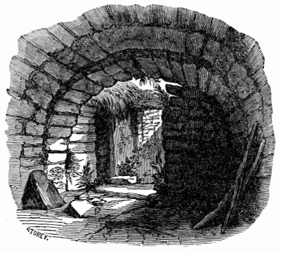
This vault, when it was first found, was supposed to have been the Ærarium of the station. Between the joinings of the floor, which were of thin free-stone flags, were found several counterfeit denarii, both of copper and iron plated with silver. 174The approach to it was by four steps downwards, the lowest of which was a large centurial stone, which had borne an inscription, but nearly all of it had been purposely erased. On the outside of the threshold was found, in a sadly decayed state, its original door of wood, strongly sheathed with plates of iron, and the whole firmly rivetted together with large square nails. Within the door, which had opened inwards, the end wall was two feet thick, plastered and painted. Its internal area is ten feet by nine, and its height to the crown of the arch six feet four inches.[85]
175
Ground-plan, Hypocaust, Cilurnum.
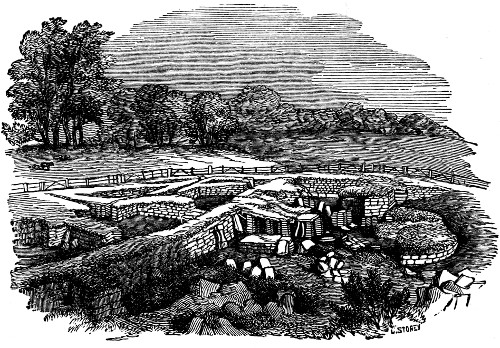
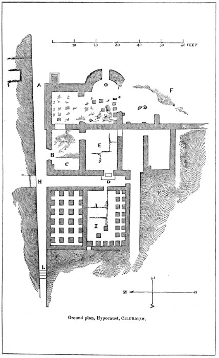
Some buildings situated near to the spot where the eastern gateway must be, and which have recently been freed from the earth and rubbish that have long enveloped them, are objects of still greater interest. Their general appearance, as seen from a slight elevation, is shewn in the adjoining wood-cut, while, for a more minute knowledge of their size and arrangements, reference may be made to the plan on the opposite page. Eight apartments have 177already been exposed, and a little more research would doubtless display others.
THE HYPOCAUSTS.
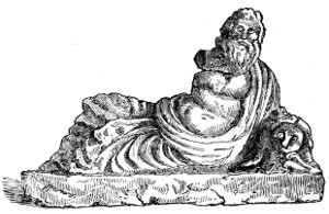
Descending a few steps (at L in the Plan), a street three feet wide at one extremity, and four at the other, is entered. Another, leading from it at right-angles, and which is paved with flag-stones, conducts to the grand entrance (D) of what appears to be the principal section of the building. The steps are very much worn down by the tread of feet, and even some of the stones, which have evidently been put in the place of others that have been too much abraded to be serviceable, exhibit partial wear. This saloon must have been a place of general concourse—can it have been the hall of justice, or the place where the commander of the station transacted the business of the district under his charge? The floor (E) is probably supported on pillars, and has been warmed by flues beneath; but this cannot be ascertained without injuring it. The upper covering is of flags, the fractured state of which induces the belief, that the walls of the surrounding building have been forcibly thrown down upon them. The northern enemies of Rome, knowing the importance of these stations, would not be slow in involving them in entire ruin, when permitted, by the withdrawal of the troops, to do so without molestation. Passages diverge from this saloon, to the right and left, into other apartments. In the room on the left was found, in good preservation, a cistern or bath (C), lined with red cement. A breach had been made in the street 178wall of this chamber (at B), and in the rubbish which encumbered the gap, was found the statue of a river-god, of which a correct sketch is here given. It is probably intended to represent the genius of the neighbouring river—the North Tyne. Although executed in coarse sand-stone, it is not without considerable gracefulness of attitude and proportion. It is preserved in the mansion at Chesters. Of the present state of the apartments beyond, the wood-cut in the previous page, and the lithograph here introduced, will give an accurate conception. The floors have been supported upon pillars, some of them being of stone, others of square flat bricks. The stone pillars are, for the most part, fragments of columns and balusters which have been used in a prior structure.[86] The student of mediæval architecture will probably recognise in some of them types of the Saxon style. The dilapidated state of the floor of this apartment allows of an easy examination of its mode of construction. Flags, about two inches thick, rest upon the pillars; a layer of compost, five inches thick, and formed of lime, sand, gravel, and burned clay or pounded tile, succeeds, and above that, another covering 179of thin flag-stones.[87] This apartment has been provided with a semicircular recess at its eastern extremity (G), and, at the angle next the street (A), has been supported by a buttress. A similar alcoved recess existed on the western side of one of the principal rooms of the ‘baths’ at Hunnum, and the same arrangement may yet be observed in the corresponding building at Lanchester. All of these buildings have been strengthened with buttresses, but it is only in these and analogous cases, that the use of the buttress is admitted among the erections of the Barrier; it never occurs in the great Wall or the curtain-walls of the stations. In the circular recess|THE HYPOCAUSTS.| of this apartment is an aperture (G), which probably has served to regulate the current of air circulating in the hypocausts. The furnace which warmed the suite of apartments was situated near the south-east extremity of the building (at F); the pillars near the fire having been much acted upon by the heat, the whole of this part of the floor was reduced, on exposure to the frosts of winter, to the confused heap represented in the drawing. The soot in the flues was found as fresh as if it had been produced by fires lighted the day before.[88] The walls of this apartment were coated with plaster, and coloured dark red; exposure to the weather 180soon stripped them of this covering. An arched passage curiously turned with Roman tile took the heated air from the furnace through the party-wall (at X) into the chamber to the west of it. The rooms to the westward of the intersecting street (HD), seem to form an independent building, and have less of the aspect of a place of public concourse than the other portions. They may have been the private residence of the commander of the station. They, too, are heated by hypocausts.
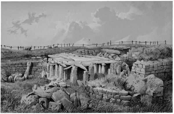
H. Burdon Richardson, Delt.John Storey, Lith. HYPOCAUST AT CHESTERS, (CILURNUM) Printed by W. Monkhouse, York
CILURNUM.
In urging the conviction, that the hanging floors of these Roman buildings were meant to produce a comfortable warmth, rather than to generate steam, by having water sprinkled upon them, attention may be drawn to the thickness of their substance. At present, the floor of the principal apartment is nine inches thick, and when its upper surface was overlaid, as it no doubt was, with a tasteful concrete or mosaic pavement, it would be an inch or two more. It would require a very powerful furnace to raise this mass of matter to a considerable temperature. On the other hand, if the production of a genial and uniform warmth were the object in view, no contrivance could be more suitable. The heated air from a small furnace permeating the underground flues and the walls of a suite of apartments, and not passing off until, in its lengthened passage, it had given out the larger part of the warmth it had derived, would, in the lapse of some hours, give to the whole building a comfortable temperature, which it would not readily lose. Any inattention 181to the furnace, either by causing it to burn too fiercely or too feebly, would not be felt. The thickness of the floors would prevent the air from being scorched, and producing that disagreeable sensation which is experienced in rooms that are heated by the stoves in common use. It is not improbable that we may return to this method of warming our churches and public halls, even if we do not adopt it in our private buildings.[89]
METHOD OF WARMING BUILDINGS.
The door-ways of some of these apartments have been provided with double doors, probably for more effectually maintaining the warmth of the room.
The masonry of those portions of the walls which are standing, is in an excellent state of preservation. In the angle near the buttress (A), the action of the trowel in giving the finishing touch to the pointing may be perceived. The walls rest upon two strong basement courses, the angle of the uppermost being bevelled off with a neat moulding.
182Some of the quoins of the door-ways consist of very large stones; one is six feet long, and is probably a ton in weight. This proves that it was not from lack of mechanical means that the interior buildings and walls of the stations were composed of small stones. More than one of the thresholds have a groove very roughly cut in them, apparently to allow of the egress of water. This has probably been done after the departure of the Romans and the general demolition of the buildings, by some houseless wanderers, who, having ‘camped’ in the ruin, were incommoded by the lodgement of rain on the floor.
The hydraulic properties of the concrete used in the floors of Roman hypocausts, has, I believe, escaped the notice of previous writers, and is the only other point which need longer detain us in this interesting building. My attention was drawn to this subject by my brother, Mr. George Barclay Bruce, Member of the Institution of Civil Engineers, in the following communication:—
In many places on the line of the Wall, the mortar has had mixed with it broken tiles or burned clay, to assist it in resisting the moisture of the atmosphere.
The concrete at Chesters placed between the slabs of the bath-room, has a very large proportion of this burned clay, and would thus be better suited to resist the action of heat below and water above than purer lime.
A portion of this concrete was taken, by way of experiment, and burned in a crucible, as though it had been a piece of limestone; it was then ground fine, and mixed with a proper quantity of water; after being allowed to dry for three or four hours, it was immersed in water, where it set in the same manner as common mortar does in the open air, clearly proving 183its hydraulic properties. The same experiment was tried with the ordinary mortar of the Wall, but without the same result, there not being a sufficiently large quantity of burned clay to enable it to stand so severe a test. In the case of the concrete, it did not set so readily as what is called Roman cement, but sufficiently so to prove that it is a strong hydraulic mortar, made by the mixture of burned clay with common lime.
THE CEMETERY.
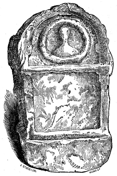
Bidding farewell to these interesting structures, we may now bend our steps a short way down the river, on a visit to the cypress-grove—the burial ground of the station. This, which in Horsley’s days formed a separate field called the Ox-close, is now included in the park of the domain. Never was spot more appropriately chosen. The river here descends with more than usual rapidity over its stony bed, and bending at the same time to the left, exhibits to the eye the lengthened vista of its well-wooded banks. No earthly music could better soothe the chafed affections of the hopeless heathen mourner than the murmur of the stream which is ceaselessly heard in this secluded nook. From this spot have been procured several sepulchral slabs which will presently afford us instruction; meantime, one is given on the next page whose lesson is of a negative character. The blank memorial shews how vain are the efforts which even affection makes to render buoyant on the wave of time the memory of those departed. Our very monuments need memorials. But, passing this, the character of the carving betokens a poor state of the arts, and fixes its date in the lowest times of the empire: in this we have a proof of the long-continued occupation 184of the station. The fate of the stone has been singular. When Horsley saw it, the inscription was legible; but having since been used as the door-stone of the cow-house at Walwick Grange, the letters had, previous to its removal to Alnwick-castle (its present resting place), been entirely obliterated.
Between the station and the cemetery is a well enclosed with Roman masonry; it is now in a great measure filled up.
185
ITS NAME ASCERTAINED.
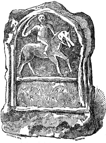
The station of Cilurnum, which is the sixth on the line of the Wall, was garrisoned by the second wing of the Astures, (a regiment of Spanish cavalry) commanded by a prefect. This fact has gradually developed itself to the antiquary. Camden thought it probable. Horsley concurred in the opinion, and, in the absence of better evidence, sagaciously referred to the tombstone of which a drawing is here presented, in proof of its having been occupied by a horse regiment. ‘That some horse,’ says he, 'kept garrison here in the lower empire, seems to be probable from the inscription and sculpture yet remaining at Walwick-grange.'[90] ‘The letters D. M.,’ he remarks in another place, ‘prove this to be a sepulchral monument, and the figure shews that the deceased belonged to the horse, and therefore probably was one of the Ala secunda Astorum, which in the lower empire kept garrison at Cilurnum, as the Notitia informs us.’
186
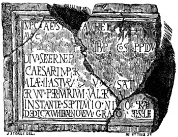
More decisive evidence has since been procured. The slab figured on page 61, is part of it. A still more satisfactory document of stone was discovered at Chesters several years ago, where it is still preserved: the wood-cut accurately portrays it.
IMP[ERATORI] CAES[ARI] MARCO AVREL[IO]
AUG[VSTO] . . . . . . . . . . . . PONTIFICI MAXIMO
TRIB[VNITIA] P[OTESTATE] CO[N]S[VLI] IV P[ATRI] P[ATRIÆ] DIV[I] ANTONINI FILIO
DIVI SEVER[I] NEP[OTI]
CAESAR[I] IMPER[ATORI] . . . . . . . . . . . DUPLARES
ALÆ II ASTVRV[M] TEMPLUM VETVSTAT[E] CONLAPSUM RESTITU-
ERVNT PER MARIUM VALER[IANUM] LEGATUM AUGUSTALEM PROPRÆTOREM
INSTANTE SEPTIMIO NILO PRÆ[FECTO]
DEDICATVM III KAL[ENDAS] NOVEM[BRIS] GRATO ET SELE[VCO] CONSULIBUS.[91]
To the emperor Marcus Aurelius
Augustus . . . . . . . . . . . Pontifex Maximus,
With tribunitian power, fourth time Consul, Father of his Country, of divine Antoninus the son,
Of the deified Severus the grandson,
To Cæsar our emperor . . . . . . . . the duplares[92]
Of the second wing of Astures, this temple, through age dilapidated, re-
stored by command of Marius Valerianus, Imperial Legate and Proprætor,
Under the superintendence of Septimius Nilus, Prefect.
Dedicated Oct. 30th, in the consulate of Gratus and Seleucus.
187Hutton, who has done such good service to the Wall, under-rated the value of inscriptions. ‘When the antiquary,’ says he, 'has laboured through a parcel of miserable letters, what is he the wiser?'—Let this fractured and defaced stone answer the question.[93] 1. This dedication was made by soldiers of the second wing of the Astures;—we thus learn the name of the people who garrisoned the fort, and by a reference to the Notitia, ascertain with certainty that this was|CILURNUM.| Cilurnum. 2. We acquire the fact, that a temple, which through age had become dilapidated, was restored;—learning thereby, not only the attention which the Romans paid to what they conceived to be religious duties, but their long occupation of this spot. It has been already observed, that some of the pillars of the hypocaust have been portions of a prior building;—the ruin and inscription thus corroborate each other. 3. The date of the dedication is given; the third of the calends of November falls upon the thirtieth of October, and the year in which Gratus and Seleucus were consuls corresponds to A.D. 221;—the data on which antiquaries found their conclusions, are not always so vague as some imagine. 4. Even the erasures are instructive. By a reference to the date, we find that Heliogabalus was reigning at the time of the dedication of the temple; we find that what remain of the names and titles on the stone apply to him; he, consequently, is the emperor referred to. The year following he was slain by his own soldiers, his body dragged 188through the streets and cast into the Tiber. The soldiers in Britain seem to have sympathized with their companions at Rome and to have erased the name of the fallen emperor from the dedicatory slab. Human nature is the same in every age. How often have we, in modern times, seen a name cast out with loathing which yesterday received the incense of a world’s flattery!
The above inscription gives us the station of the Ala secunda Asturum, in the reign of Heliogabalus, A.D. 221. The Notitia Imperii gives us its station in the reign of Theodosius the younger, ‘ultra tempus Arcadii et Honorii,’ A.D. 430, and we find at both periods the same force in the same station, which corresponds with the understood practice of the Roman army with regard to the permanency of the quarters of its auxiliary forces. With reference to the difference between the spelling of the inscription and the Notitia, ‘Asturum’ and ‘Astorum,’ it may be observed that as the Notitia Imperii was preserved for a thousand years in manuscript before the art of printing came to its rescue, it is more likely that the error should be in the book, than on the stone.
The ancient name of the station having been ascertained, the etymology of it may be inquired into. Whitaker says it means a creek. An authority acquainted with the Gaelic language suggests the following derivation; caol, narrow, probably pronounced by the Romans kil, and doir, water (in composition dhoir, the dh not sounded); so that caol-oir is narrow stream; the um is a usual Latin affix. Of course, this branch of the Tyne is narrow 189in comparison with the united floods. The word may have had an Italian origin; the Latin celer, swift, has some resemblance to it, and the river, when swollen by floods, very speedily discharges its superfluous water. Whatever be the origin of the word, the names of the neighbouring places, Chollerton and Chollerford, have had a similar derivation.
ROMAN SCULPTURES.
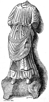
The miscellaneous antiquities which have been found here, and are still preserved upon the spot, are of a very interesting character. Chief among them is a broken statue, which is here represented.
The fragment, consisting of a fine-grained sandstone, is six feet two inches long. Statues of so large a size are of very rare occurrence in Roman camps in Britain. It is generally supposed to have been meant for Cybele, the mother of the gods. The gracefulness of the design, and the excellence of the execution, show us that the state of the arts in Roman Britain was not so low as is sometimes supposed. The arrangement of the drapery, and the ornament placed upon its margins, are suggestive of the mode in which these details were managed in 190the statues of the early ecclesiastical architects. The ancient builders professedly followed the Roman modes.
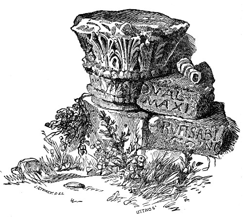
The fine Corinthian capital, which is here shewn, enables us to judge of the beauty of some of the buildings which adorned the ancient Cilurnum. In the drawing, it rests upon one of the foundation stones of the bridge; on the right-hand side of the group are two centurial stones, inscribed—
C[ENTVRIA] VAL[ERII]
MAXI[MI]
[CENTVRIA] RVFI SABI
NI
The century (or company) of Valerius
Maximus
The century of Rufus Sabi-
nus.
On the top of these is a pipe of red earthenware.
PLATE VIII
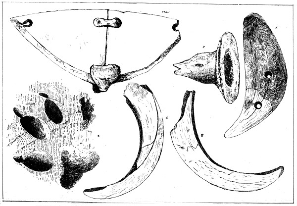
Miscellaneous Antiquities, Cilurnum
PLATE IX
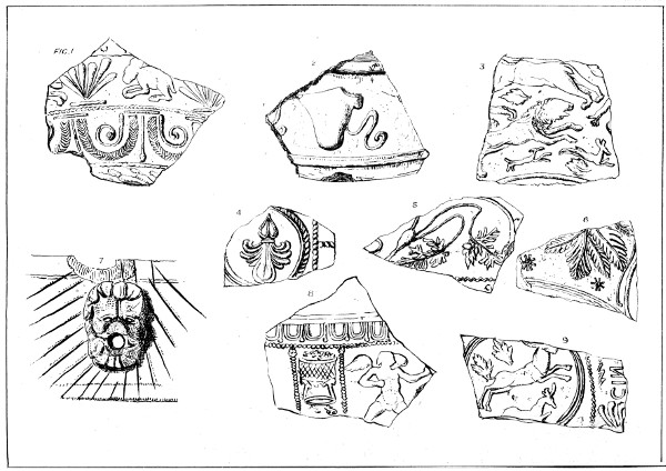
Samian Ware
MISCELLANEOUS ANTIQUITIES.
191Preserved in the collection here, is a tile of the usual Roman fabrication, on which are impressed the foot-marks of a dog, seemingly of the terrier species. The animal must have run over it while the clay was in a soft state. Plate VIII. fig. 4.
In making the excavations at the hypocausts, many coins of silver and brass were found. They extend from the reign of Hadrian to that of Gratian; those of Constantine and his immediate successors prevail. A massive silver signet ring, representing, on a cornelian stone, a cock pecking at an an ear of corn, was found in one of the rooms. As is uniformly the case, numerous fragments of the different kinds of pottery used by the Romans were turned up; some of the fragments of vessels of Samian ware are figured on Plate IX. A key, fig. 4. an iron implement with springs on each side of it, fig. 1. and a spear head fig. 3. drawn on Plate X., were found here. Some soles of sandals, similar in character to those which will afterwards be described, several glass beads of curious fabrication, and broken pieces of glass vessels, were picked up. A piece of cut glass procured here is shewn in Plate VII. fig. 10. One of the most curious relics obtained from this treasury of Roman effects was the tooth of a bear; it is of a large size, and is pierced with two holes to enable its possessor to suspend it by a string, and wear it as a trophy or a charm on his person. It is figured of the full size in Plate VII. Bears, as well as wolves, prowled in the forests of ancient Britain, and no doubt the formidable animal 192which yielded this tusk, cost its captor a severe struggle.
Not the least interesting of the circumstances of a place of very early occupation, are the traditions of the ‘ancients’ respecting it. Notwithstanding their rudeness, some latent truth may generally be educed from them; and they always manifest the modes of thought that prevailed in former times. Sixty years ago the traditions of the Wall might easily have been gathered, but now the old men have nearly forgotten the tales with which their ‘fore-elders’ used to entertain them on a winter’s evening. The products of the press have nearly superseded this unlettered lore. A few fragments relative to Cilurnum have, however, been supplied to me. A belief used to prevail, that there existed a subterranean stable under the camp capable of containing five hundred horse. It was, moreover, currently related, that beneath the river a tunnel was formed, which led to the opposite side. There is a pool in the vicinity of the station, on its western side, called the Ingle-pool, and which, until partially filled up a few years ago, was very deep; the peasantry believed, that it derived its supplies by an underground canal from the North Tyne, at Nunwick-mill, between three and four miles up the river.
PLATE X.
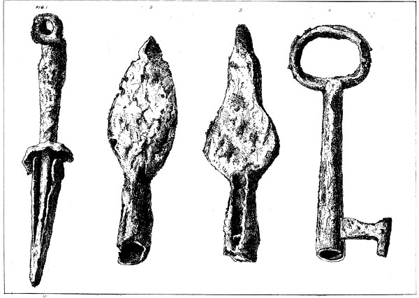
J. STOREY DEL. ET LITH.PRINTED BY ANDW. REID. Roman Spears, etc.
In these traditions we may perhaps recognise the facts, that a regiment of horse garrisoned the station; that the Romans carefully maintained the means of intercourse with both sides of the river; and that, if in this instance they did not, which is by 193no means certain, in others they undoubtedly did bring water from great distances, either for the purpose of sustenance, or to strengthen their position.
We must now take leave of Cilurnum. Whatever may be the views of the reader, the visitor will do so with regret. As Hodgson well remarks, ‘The Astures, in exchanging the sunny valleys of Spain for the banks of the tawny Tyne, might find the climate in their new situation worse, but a lovelier spot than Cilurnum all the Asturias could not give them.’ During many days spent in the prosecution of my inquiries here—the beauty of the landscape, the instructive nature of the ruins, and the pleasant intercourse which I was privileged to enjoy with the hospitable family at the hall, combined to make a deep impression upon my mind.
CHESTERS.
Again we bend our steps westward. Behind the garden wall at Chesters stands a fragment of the Wall. The north fosse is filled with water. Ascending the hill which leads to Walwick, the earth works are seen on the left hand. When near the top of it, our out-door antiquary, while he pauses for breath, will do well to look back, and contemplate the scene he is leaving. The lines of the Barrier are seen boldly descending the well-wooded and fertile banks on the east side of the river. Warden-hill is to the south, and will attract attention by its elevation. Its summit is seen still to bear marks of having been occupied by the aborigines of Britain. Whilst the works of the Barrier were going on, they 194may have maintained their position for a while, and, from behind their entrenchments, scowled upon the intruders who were soon to drive them to the remoter region of the Cheviots. After watering both sides|WARDEN-FELL.| of the tongue of land of which Warden-fell consists, the North and South Tyne meet, and their waters roll on in a united stream to the Emporium of the North. We can follow it with the eye for some distance, as it goes sparkling in the sunshine, spreading fertility and beauty on either hand.
... O ye dales
Of Tyne and ye most ancient woodlands; where
Oft as the giant flood obliquely strides,
And his banks open, and his lawns extend,
Stops short the pleased traveller to view,
Presiding o’er the scene, some rustic tower,
Founded by Norman or by Saxon hands.
Nestled in the fairest part of the valley is the abbey church of Hexham; closely inspected, it is found to be a chaste specimen of the most simple and beautiful of our ecclesiastical styles—the early English, and, when viewed from a distance, as in this case, its venerable towers lend a quiet charm to the landscape.
How different the scene which the Romans beheld! In their day, and for long afterwards, the painful cultivator of the soil knew not who should reap the harvest; those only, therefore, who had power to protect themselves would engage in the occupation. Now, the husbandman dreams not of a foreign foe, or of troops of lawless marauders; 195steadily he evokes the riches of the soil, and something like an Eden smiles!
A strip of the Wall, though in a disordered state, and covered with brushwood, is in a field beyond Walwick; its fosse is finely developed.
TOWER-TAY.
Ascending the next hill, called Tower Tay, the earth-works are still very conspicuous. About half way up are the ruins of a tower, erected about a century ago, as an object in the landscape. It stands on the Wall, and has been entirely formed out of its stones. At the summit, the ditches of both Wall and Vallum are cut through the native rock, of which the hill consists, and are in excellent order. The Wall stands very near the edge of a scar, sufficiently elevated to have formed of itself a defence; it is remarkable that the Romans should have thought it necessary to draw a ditch on the north side of it at all.
Looking forward from the top of this hill, we see, for a considerable distance, all the lines of the Barrier proceeding on their course; descending one hill and ascending the opposite, called the Limestone-bank, they keep perfectly parallel. It would have delighted Horsley’s heart to notice that the present road runs upon the north agger of the Vallum, maintaining, as he did, that this was the Military Way of Agricola.
At a short distance, further in advance, the ruins of a mile-castle are seen on the right. The whole of the facing-stones are gone, as is usually the case, and the place where it stood is chiefly marked by the 196vacuity occasioned by their removal. This castellum measures, inside, fifty-four feet from east to west, and sixty-one from north to south; it has been protected by a fosse. A long range of the Wall is next seen in the Black-carts farm, in an encouraging state of preservation; it is between five and six feet high, and shews, in some places, seven courses of facing-stones.
TEPPER-MOOR.
On the summit of the next hill, many objects of great interest await us. The view from it is most extensive. To the north, a vast sweep of country meets the eye; a beautiful undulated valley occupies the foreground, behind it the hills rise boldly, and the lofty Cheviots bound the scene. Chipchase castle occupies a commanding position. The modern mansion of Nunwick, embowered in wood, selects the lower ground. Towards the west, the lofty crags traversed by the Wall come into view.
In the corner of a field adjoining the road, are the remains of another mile-castle; it measures fifty-seven feet by fifty-four. Horsley says, it was detached about a yard from the Wall, the reason of which was not very obvious. A portion of the Roman Military Way may here be seen as it curves towards the gateway of the castellum, and again recedes from it. A good section of it is obtained at the margin of the places where its stones have been removed to form the stone dikes of the field.
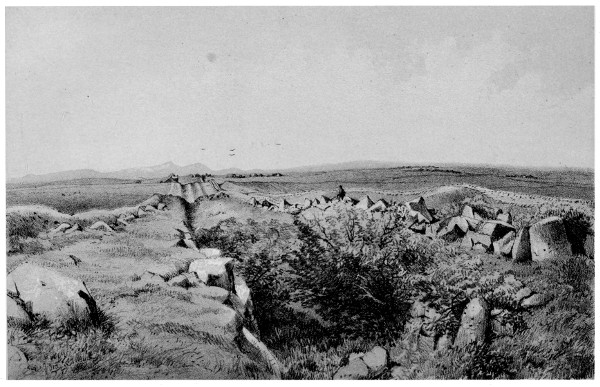
H. Burdon Richardson, Del.John Storey, Lith. THE WORKS, TEPPER MOOR.
The fosse of the Wall and Vallum at this point deserve attentive examination. In passing over the crown of the hill, they have been excavated with 197enormous labour out of the basalt of which the summit consists. The workmen, as if exhausted with the task of raising the splintered fragments, have left them lying on the sides of the moats. A mass on the outside of the north ditch, though now split by the action of the frost into three pieces, has evidently formed one block, and cannot weigh less than thirteen tons. It is not easy to conceive how they managed to quarry so tough a rock without the aid of gunpowder, or contrived to lift, with the machinery at their command, such huge blocks. No luis-holes appear in them.
The lithograph presents a view of the giant works of the Vallum and fosse at this point. It is quite evident that here, at least, the north agger did not form the Military Way. There are several breaks and irregularities in both the mounds; the works have probably been left by the Romans in a rough, unfinished state.
Between this spot and the craggy summit on which Sewingshields farm-house is perched, the ground is flat, and destitute of any decided descent to the north. On this account, and for mutual defence, the lines of the Barrier keep close together, so close, sometimes, as scarcely to leave room for the passage of the Military Way between them.
PROCOLITIA.
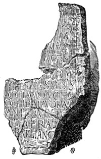
PROCOLITIA is the seventh stationary camp on the line of the Wall. It was garrisoned by the first Batavian cohort, which, with two others from the same country, and the two Tungrian cohorts, 198was with Agricola in his great battle with Galgacus in the Grampian Hills. That the ruined camp at Carrawburgh was the adopted home of this cohort, is proved by the altar engraved on page 62, and by the fractured slab now introduced,[94] and which was found here in the year 1838. On this mutilated stone, the words COH I BATAVORVM are quite distinct, and are of themselves sufficient, not only to fix the site of the ancient Procolitia, but to corroborate the testimony of Tacitus, on the presence of Batavians in Britain during the period of Roman occupation. The line following may probably be read INST[ANT]E BVRRIO, and bears the name of the prefect under whose superintendence the building was erected, to which the slab referred. In the last line, the word CO[RNELIANO may be perceived. In 237, when Maximinus was emperor, Titius Perpetuus and Rusticus Cornelianus were consuls. That this is the date of the inscription is rendered likely from a fragment of this emperor’s name appearing in the beginning of it.
Whitaker gives, as the meaning of the word Procolitia, the ‘fortress in the woodlands.’ In the Gaelic tongue, coille signifies a wood.
199There is little in this station to detain us. The course of its ramparts and moats can be easily traced, and the rich green sward of its area is seen to cover numerous irregular heaps of ruins; every building, however, is prostrate; scarcely one stone is left upon another. The Wall forms the northern boundary of the station; its eastern and western gateways are, as usual, opposite to each other, but strike the side walls between the upper end and the middle. The position of the southern gateway cannot be detected; in the present state of the ruins, there is no appearance of one. The southern corners are rounded off, but the side walls of the station, in joining the Murus on the north, seem to preserve their rectilinear course. Outside the western wall are the ruins of the suburbs. A natural valley, consisting at present of boggy ground, gives strength to the fortification on this side. Horsley saw a well in the slack, cased with Roman masonry; it is now removed.
No modern habitation is on the ground or in its immediate vicinity to relieve the general desolation—
... here, as in the wild,
The day is silent, dreary as the night;
None stirring save the herdsman and his herd,
... or they that would explore,
Discuss and learnedly.
CARRAWBURGH.
Passing onwards, we soon reach the farm-house of Carraw, formerly a rural retreat of the priors of Hexham. On the crown of the next elevation, the works are brought into close proximity, apparently 200for the purpose of avoiding an extensive bog on the north, and of maintaining possession of the point of the hill on the south. The earth-works are very boldly developed, but are in a ragged state. The contents of the north fosse are piled up high on its outer margin. The fosse of the Vallum is cut through free-stone rock; its southern agger is very elevated, and would present a bold and angry front to any intruder from the south.
THE GREAT MURAL RIDGE.
We must now, to adopt the language of Hutton, ‘quit the beautiful scenes of cultivation, and enter upon the rude of nature, and the wreck of antiquity.’ Four great mountain waves are before us, and seem to chase each other to the north, on which side their crests rise almost perpendicularly. To the highest of these, the second from the south, the Wall directs its course. It is a ridge of basalt, which crosses the island obliquely, from Cumberland to Holy Island. The Vallum here parts company with the Wall, and takes the ‘tail’ of the hill on the ‘crag’ of which the other runs. The accompanying drawing shews the nature of the country before us.
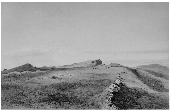
H. Burdon Richardson, Delt.John Storey, Lith. APPROACH TO SEWINGSHIELDS. Printed by W. Monkhouse, York
Before approaching Sewingshields[95] farm-house, which is on the line of Wall, an experienced eye will detect the Roman Military Way. It runs at first nearly parallel with the Wall, at about thirty-six paces from it, but, in its subsequent course, recedes from the Barrier, or approaches it, according 201to the position of the mile-castles, and the nature of the ground. With but few interruptions, it may be traced by the appearance of its herbage, by its slightly elevated, rounded form, and by the occasional protrusion of the stones composing it, all the way from Sewingshields to Thirlwall.
The north fosse, which we have had in view from the very commencement of our journey, accompanies the Wall for a short distance up the hill, as is seen in the lithograph, but when the ground becomes precipitous, it forsakes it until the high grounds are passed, only to appear when the Wall sinks into a gap or chasm between the crags.
THE WALL ON THE CRAGS.
A difficulty will here present itself to nearly every mind; why was the Wall drawn along the cliffs at all? Horsley cut the knot instead of untying it. ‘As such steep rocks,’ says he, ‘are a sufficient fence of themselves, I am inclined to think the Wall has not in those parts had either strength or thickness, equal to what it has had in other parts.’ Present appearances give us no reason to suppose that the Wall on the crags was in any respect inferior to what it was in the low grounds. A different method of accounting for the circumstance has been forced upon my attention. It was my fortune to traverse the heights near Sewingshields late in December last year, when the wind blew a violent gale from the north, and the thermometer, even in the valley, was ten degrees below the freezing point. In order to maintain the ordinary temperature of the body, very active exertion was necessary, and to make any progress on 202my way, I was constrained to get under the lee of the hill. The conclusion was irresistible; if the Romans were to keep watch and ward here during the winter, a Wall was necessary, even though only for the sake of sheltering them from the blast. The habits of the enemy demanded continual vigilance; for, as Tacitus tells us, before the time of Agricola they usually repaired the losses they had sustained in summer by the success of their winter expeditions. The loftier the mountain peak, the more necessary, in this view of it, was the friendly shelter of the Wall to the shivering soldiers of southern Europe.
SEWINGSHIELDS.
The Wall in the neighbourhood of Sewingshields is not in good condition; its site is marked by the rubble which encumbers it, but the facing-stones are gone, having contributed to the erection of every building in the vicinity, from the time of Honorius to the present day. A considerable tract of it was removed lately. Thorough draining, the life of agriculture, is death to the Wall.
The aspect of the country in the immediate vicinity of the heights of Sewingshields is dreary enough, but the elevation enables the eye to revel in the fertility and beauty of the distant landscape. Hexham is distinctly discernible from the farm-house. On the flats to the north of the crags, there formerly stood the border fortress, Sewingshields castle.[96] It 203was at one time the property of the late Ralph Spearman, esq., the Monkbarns of The Antiquary.
MURAL TRADITIONS.
A situation so remote from the crowded haunts of men is favourable to the preservation of legendary lore. It occurred to me that here, if anywhere, I might ascertain the kind of ideas which the rude forefathers of the mural region entertained respecting the Wall and its builders. Although on the Antonine Wall all tradition of the Romans has been lost, this has certainly not been the case here; the recollection of them is still distinctly preserved, and some stories of them are told, which, though in several respects resembling written history, are not derived from this source. For the following scraps of traditional information, I am chiefly indebted to the master of Grindon school, in the immediate neighbourhood of Sewingshields, who says he has often heard them repeated. Though he denominates them ‘absurd,’ the learned in mediæval legends will probably think them worth preserving.
The Romans are said to have been remarkably lazy, so much so, that in the hot weather of summer, having almost nothing to do, they lay basking in the sun, on the south side of the Wall, almost in a state of torpor. The Scots were in the habit of watching their opportunity, and, throwing hooks, with lines attached to them, over the Wall, caught the poor Romans by their clothes or flesh, and by this means, dragging them to the other side, made them prisoners.
An old man in this neighbourhood told me, that he had often heard people say, that the Romans had remarkably broad feet, with still broader shoes, and that, when it rained, they lay on their backs, and holding up their feet in a perpendicular direction, protected, by this means, their persons from the 204weather.—This legend, under various modifications, seems to have been widely diffused in the middle ages. Sir John Maundevile, describing ‘Ethiope,’ says—‘In that contree, ben folk that han but o foot; and thei gon so fast, that it is marvaylle; and the foot is so large, that it schadewethe all the body azen the sonne, whan they wole lye and reste hem.’ Precisely similar to this is Pliny’s account—'Item hominum genus, qui Monoscelli vocarentur, singulis cruribus, miræ pernicitatis ad saltum: eosdemque Sciopodas vocari, quod in majori æstu, humi jacentes resupini, umbra se pedum protegant.'[97]
It is the tradition of the country that all the stones of the Wall were handed from one man to another by a set of labourers stationed in a line from the quarry to the place where they were required. Many will tell you, 'I have heard my mother say, that the Wall was built in a single night, and that no one was observed to be engaged upon it, save an old woman with an apron full of stones.'—This, however, is a tradition of almost universal application.
The people say that the Wall was hollow, or, as they express it, had a flue running the whole length of it, through which the sentinels communicated intelligence by a speaking trumpet.
Some of the people of this neighbourhood tell me that the Britons, tired, at length, of Roman oppression, rose in a body, and drove the garrison, with considerable slaughter, from all their stations. The Romans, when making their way to the sea to look for ships to carry them home, were met by a seer, who told them that if they returned home they would all be drowned; and if they went back to their old stations they would all be slain. This prophecy disconcerted them greatly, and they were at their wits’ end; however, after long consultation, they resolved to escape both calamities by marching direct to Wales. This they did, and there the pure, unadulterated Roman breed is to be found to this day.—Can this story refer to the passage of the second legion, at an early period, to Caerleon?
LEGENDS OF KING ARTHUR.
205We next pass on to some tales, which, though not connected with the Wall, belong, as Hodgson remarks, to times nearer the Roman than these degenerate days. They chiefly relate to king Arthur. Sir William Betham observes that this monarch’s name is more celebrated in Scotland than in Wales, which was the chief resort of the conquered Britons, and is disposed to think, that this favourite hero of romance was not a Romanized Briton, but an invading Pictish king. This idea would account for the frequent reference to his name in the region of the Wall.
Immemorial tradition has asserted, that king Arthur, his queen Guenever, his court of lords and ladies, and his hounds, were enchanted in some cave of the crags, or in a hall below the castle of Sewingshields, and were to continue entranced there till some one should first blow a bugle horn that lay on a table near the entrance of the hall, and then with ‘the sword of the stone’ cut a garter also placed there beside it. But none had ever heard where the entrance to this enchanted hall was, till the farmer at Sewingshields, about fifty years since, was sitting upon the ruins of the castle, and his clew fell, and ran downwards through a rush of briars and nettles, as he supposed, into a deep subterranean passage. Firm in the faith that the entrance into king Arthur’s hall was now discovered, he cleared the briary portal of its weeds and rubbish, and entering a vaulted passage, followed, in his darkling way, the thread of his clew. The floor was infested with toads and lizards; and the dark wings of bats, disturbed by his unhallowed intrusion, flitted fearfully around him. At length, his sinking courage was strengthened by a dim, distant light, which, as he advanced, grew gradually brighter, till, all at once, he entered a vast and vaulted hall, in the centre of which, a fire without fuel, from a broad crevice in the floor, blazed with a high and lambent flame, that shewed all the carved walls and fretted roof, and the monarch and his queen, 206reposing around in a theatre of thrones and costly couches. On the floor, beyond the fire, lay the faithful and deep-toned pack of thirty couple of hounds; and on a table before it, the spell-dissolving horn, sword, and garter. The shepherd reverently, but firmly, grasped the sword, and as he drew it leisurely from its rusty scabbard, the eyes of the monarch, and of his courtiers began to open, and they rose till they sat upright. He cut the garter; and as the sword was being slowly sheathed, the spell assumed its ancient power, and they all gradually sunk to rest; but not before the monarch had lifted up his eyes and hands, and exclaimed:
O woe betide that evil day
On which this witless wight was born,
Who drew the sword—the garter cut,
But never blew the bugle-horn.
Terror brought on loss of memory, and the shepherd was unable to give any correct account of his adventure, or to find again the entrance to the enchanted hall.[98]
To the north of Sewingshields, two strata of sandstone crop out to the day; the highest points of each ledge are called the King and Queen’s-crag, from the following legend. King Arthur, seated on the farthest rock, was talking with his queen, who, meanwhile, was engaged in arranging her ‘back hair.’ Some expression of the queen’s having offended his majesty, he seized a rock which lay near him, and, with an exertion of strength for which the Picts were proverbial, threw it at her, a distance of about a quarter of a mile! The queen, with great dexterity, caught it upon her comb, and thus warded off the blow; the stone fell between them, where it lies to this day, with the marks of the comb upon it, to attest the truth of the story. It probably weighs about twenty tons!
A few miles to the north of Sewingshields stands an upright stone, which bears the name of Cumming’s cross. Cumming, a northern chieftain, having paid, one day, a visit to king Arthur at his castle near Sewingshields, was kindly received by the 207king, and was, as a token of lasting friendship, presented by him with a gold cup. The king’s sons coming in, shortly after Cumming had left the castle, and being informed of what their father had done, immediately set out in pursuit of him. They overtook him, and slew him at this place, which has borne the name of Cumming’s cross ever since.
King Arthur’s chair used to be pointed out in this vicinity. It was a column of basalt, fifty feet high, slightly detached from the rest of the cliff. The top of it had something of the appearance of a seat. It was thrown down, several years ago, by a party of idle young men, who were at great pains to effect their foolish purpose.
SEWINGSHIELDS CRAGS.
We now return to our more immediate object, the examination of the Wall.
Soon after leaving Sewingshields, a narrow chasm in the rocks, slightly aided by art, called the Catgate, admits of an awkward descent to the plain below. Here, says Hutton, the Scots bored under the Wall, so as to admit the body of a man. Whether the Romans or the Scots made this passage, it is certain that the garrison on the Wall would sometimes visit the country to the north, for the purposes of plunder and of slaughter, and would require the means of egress.
The mile-castles may now all be recognised in due succession.
BUSY GAP.
The next point of interest is Busy-gap, a broad, basin-like recess in the mountain ridge, about a mile from Sewingshields. The Wall here, being more than usually exposed, is not only strengthened with the fosse common in the low grounds, but has the additional protection of a rampart, of triangular 208form, to the north of this. The wood-cut will give some idea of the arrangement. A common stone dike occupies at present the place of the Wall, the foundations of which, and, for the most part, a portion of the grout of the interior, remain. At a little elevation, on the western side of the valley, is a gate called the King’s-wicket (Arthur’s again, probably), through which a drove-road passes. The gate is well situated for defence, and may have been a Roman passage.
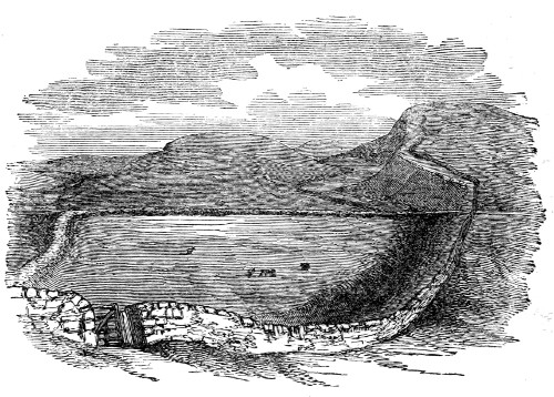
Busy-gap was in the middle ages a place of much notoriety; it was the pass frequented by the moss-troopers and reavers of the debateable country.
STATE OF THE BORDERS.
The incessant war which was waged between England and Scotland before the union of the two kingdoms, rendered property exceedingly insecure, and nurtured a race of men who had no expectation of holding their own, unless they could repel force 209by force. It was the policy of the governments of both countries, to maintain on the Borders a body of men inured to feats of arms, whom, on any emergency, they might call to their assistance. Habits long indulged are not easily laid aside. When the policy of Elizabeth, and the accession of James to the throne of England, allayed the national strife, the stern warriors of the Border degenerated into sheep-stealers; and, instead of dying in the fray, or yielding their necks honourably to the headsman’s stroke, burdened by the score the gallows-tree at Newcastle or Carlisle. The vales of North Tyne and the Rede, which anciently abounded with warriors, became infested with thieves. It is impossible to imagine the desolation and misery occasioned by such a state of society. Landed property was of little value. Precious life was idly sacrificed. Bernard Gilpin, the ‘apostle of the north,’ was esteemed a brave man because he annually ventured as far as Rothbury to preach the gospel of peace to the lawless people of the vale of Coquet. Camden and sir Robert Cotton, though ardently desirous of examining the Wall, durst not venture in their progress eastward beyond Carvoran. ‘From thence,’ Camden says, ‘the Wall goeth forward more aslope by Iverton, Forsten, and Chester-in-the-Wall, near to Busy-gap, a place infamous for thieving and robbing, where stood some castles (chesters they called them), as I have heard, but I could not with safety take the full survey of it, for the rank robbers thereabouts.’ In such ill-repute were the people of these 210parts, even in their own county, that we find the Newcastle Merchants’ company in 1564, enacting that ‘no free brother shall take non apprentice to serve in the fellyshipe of non such as is or shall be borne or brought up in Tyndale, Lyddisdale, or any such lycke places, on pain of 20ll,’ because, says the order, ‘the parties there brought up are known, either by education or nature, not to be of honest conversation; they commit frequent thefts and other felonys, proceeding from such lewde and wicked progenitors.’ The offence of calling a fellow-free-man ‘a Bussey-gap rogue,’ was sufficiently serious to attract the attention of a guild; a case of this kind being recorded in the books of the Bakers and Brewers’ company of Newcastle-upon-Tyne, 1645.
The traces of this disordered state of society remained until the early part of the reign of George III., when the sheriff of Northumberland was first enabled to execute process in the north-western parts of the county. ‘Within my own recollection,’ says Mr. Hedley, ‘almost every old house in the dales of Rede and Tyne was what is called a Peel house, built for securing its inhabitants and their cattle in the moss-trooping times.’ Very many of these yet exist. Far different is the state of the district now. The men of the mural region, and of the vales of North Tyne, and Rede-water, are as upright as any in England. With the exception of a few aged individuals, an uneducated person is not to be found. Although, in addition to the ordinary courts of law, they have access to courts-leet and courts-baron, (those admirable 211institutions by which our Saxon forefathers gave to the poorest villager the ready means of procuring redress of wrong,) nowhere has the law less occasion forcibly to assert its claims. Property is secure, and land brings its full price in the market. On some of the extensive farms of the Cheviot range, not fewer than ten thousand sheep are kept; they are counted but twice a year, and seldom is one amissing. The value of land in Northumberland (exclusive of towns and mines) is seven times greater than it was at the commencement of the eighteenth century, and two hundred times what it was in the middle of the sixteenth. The antiquary, who will not fail to rejoice in the prosperity of the country through which he is travelling, as well as in the safety of his own person, may therefore go on his way cheerfully and in confidence.
The second mile-castle from Sewingshields, opposite the farm-house called the Kennel, is remarkable as having been built upon an absolute declivity. Hodgson observes that it had an interior wall on every side of it, at the distance of about twenty feet from the exterior wall.
THE BLACK DIKE.
Shortly after leaving Busy-gap, two narrow, but rather steep gaps are passed in quick succession, which do not seem to have obtained names. Through the first of these the Black Dike has probably run. This is an earth-work of unknown antiquity, which is supposed to have stretched, in a nearly straight line, from the borders of Scotland near Peel-fell, through Northumberland and Durham, to the south of Yorkshire. 212The scantiness of the soil on the crags of the Wall, accounts for its not being discernible there, and the ground immediately to the north and south of it is boggy. In a plantation on the hill side, opposite to where we now are, looking south, the dike exists in excellent preservation. The seuch, or slack of it, may be seen even from the Wall, on the western edge of the plantation, which is called the ‘Black-dike planting.’ From the information of those who knew it half a century ago, I shall set down its probable course in this vicinity. Coming in a south-east direction, it passes the east end of Broomlee-lough; having cleared the Wall and Vallum, it goes by the west of Beggar-bog, the east of Low Morwood, through the Muckle-moss, and so to the Black-dike plantation. Passing afterwards a field called the Black-hall, it is last seen on the north bank of the Tyne near the Water-house. It re-appears on the south bank at Morley, and passing Tedcastle and Dean-row, is supposed to go by Allenheads into the county of Durham. In the best piece of it which I have seen, the ditch is ten feet across the top, and about five feet deep, reckoning from the top of the mound on its east side. Within the memory of my informants, it was much deeper. The sheep were often covered up in it in a snow-storm, as they naturally went there for shelter. The earth taken out of the ditch is uniformly thrown to the east side, where it forms an embankment. No stones, or such only as were derived from the cutting, have been used in its formation. The only conjecture hazarded respecting its origin is, that it formed the line 213of demarcation between the kingdoms of Northumbria and Cumbria; and certainly the course pursued by the Black-dike is very nearly similar to the boundary assigned to these regions in the most authentic maps of Saxon England. The antiquity of the cutting may be inferred from the circumstances, that for some distance it forms the division between the adjacent parishes of Haltwhistle and Warden, and that it passes through bogs which probably owe their origin to the devastations committed in the north of England by William the Norman.[99] The Black-dike is laid down in the map of Northumberland which was prepared to accompany Horsley’s Britannia, and in Kitchin’s Map of Northumberland, under the name of the ‘Scots’-dike.’
South of the turnpike road, and behind a small house, called Beggar-bog, is a low freestone crag, which exhibits some quarry-like excavations, filled with the chippings of stone. It has probably furnished material for the Wall, the stone being of the same character.
The stream which we next cross is the Knag-burn; it forms the eastern boundary of Housesteads. Passing it, we scale the ramparts of this far-famed station.
THE ANCIENT BORCOVICUS.
214BORCOVICUS.—‘This’ says Gordon, ‘is unquestionably the most remarkable and magnificent station in the whole island;’ and ‘it is hardly credible what a number of august remains of the Roman grandeur is to be seen here to this day, seeing in every place where one casts his eye there is some curious Roman antiquity to be seen: either the marks of streets and temples in ruins, or inscriptions, broken pillars, statues, and other pieces of sculpture all scattered along the ground.’ Stukely, in the vehemence of his admiration, denominates it ‘the Tadmor of Britain.’ Let not the visitor, however, approach it with expectations too greatly excited. There is very much to admire, but not a great deal to strike the eye at first sight. The altars and sculptured figures which lay in profusion on the ground when Gordon and Stukely were there, have been removed,[100] but the ruins of the place remain as complete and vast as ever. The city is, in a great measure, covered with its own debris, but the excavations which have recently been made, shew us that when they are continued throughout the entire station, the ancient Borcovicus will be the Pompeii of Britain.
HOUSESTEADS.
The station of Housesteads contains an area of nearly five acres. 'Half of it hangs on a slope, with a southern aspect: the other, or northern half, is flat, floored with basalt, covers the summit of a lofty ridge, and commands a prospect on the east, south, 215and west, far away beyond the valley of the Tyne, over blue air-tinted grounds and lofty mountains; and to the north of the Wall, over the vast waste of the forest of Lowes, where indeed, a proud, stupendous solitude frowns o’er the heath.'
The Wall forms its northern boundary, and the Vallum, it is probable, came to the support of its southern rampart.[101] It is naturally defended on all sides, except the west. In order duly to protect this side, the gateway seems to have been walled up at an early period, and a triple line of ramparts drawn along it.
Although the position of Housesteads clearly indicates that this fort was erected for the accommodation of a mural garrison, it would seem to have been built independently of the Wall. The first anxiety of the soldiers engaged in that great work would be to erect a secure habitation for themselves. The west wall of the station, instead of coming up to the great Wall in a straight line, makes the curve which is usual in those corners of a camp that are independent of the Wall; as is shewn in the wood-cut at the top of the next page.
216
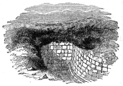
BORCOVICUS.
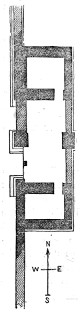
All the gateways, except the north, have been explored, and present very interesting subjects of study to the antiquary. The western|WEST GATEWAY OF BORCOVICUS.| is in the best condition, and is specially worthy of attention. Its arrangements will readily be understood by an inspection of the ground plan which is here introduced, together with the views of it as seen from the outside and inside of the station, on the next page. This gateway, as well as the others which have been explored, is, in every sense of the word, double. Two walls must be passed before the camp can be entered; each is provided with two portals, and each portal has been closed with two-leaved gates. The southern entrance of the outside wall has alone, as yet, been entirely cleared of the masonry that closed 219it. The jambs and pillars are formed of massive stones of rustic masonry. The doors, if we may judge from the fragments of corroded iron which have been lately picked up, were of wood, strengthened with iron plates and studs; they moved, as is apparent from the pivot-holes, upon pivots of iron. In the centre of each portal stands a strong upright stone, against which the gates have shut. Some of the large projecting stones of the exterior wall are worn as if by the sharpening of knives upon them; this has probably been done by the occupants of the suburban buildings after the closing of the gateway. The guard-chambers on each side are in a state of choice preservation, one of the walls standing fourteen courses high. Were a roof put on them, the antiquary might here stand guard, as the Tungrians did of old, and, for a while, forget that the world is sixteen centuries older than it was when these chambers were reared. At least two of the chambers in this part of the camp have been warmed by U shaped flues running round three of their sides beneath the floor.[102] These chambers, when recently excavated, were found to be filled with rubbish so highly charged with animal matter as painfully to affect the sensibilities of the labourers. The teeth and bones of oxen, horns resembling those of the red-deer, but larger, and boars’ tusks were very 220abundant; there was the usual quantity of all the kinds of pottery used by the Romans. It is not improbable that this rubbish may have been derived from some dunghill outside the walls, and thrown here when the gateway was walled up; it is, however, a remarkable fact, that the soil of the interior area of the stations on the Wall is, for the most part, thickly mingled with bones. Is it possible that the Romans have thrown on the floors of their apartments, and suffered to remain amongst the straw or rushes which may have covered them, the refuse of their food?
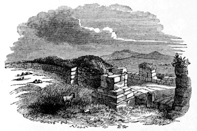
Outside View of the West Portal of Borcovicus.
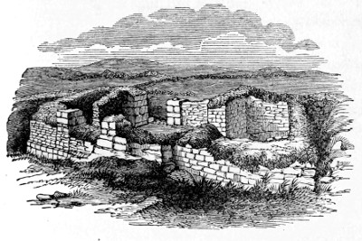
Inside View of the West Portal of Borcovicus.
The view of Housesteads in the accompanying lithograph, is taken from beside the eastern gateway, and gives a general idea of the scene of desolation which it presents.[103] The only habitation near is a shepherd’s cottage to the south of the station. A peculiarity in the upper division of the eastern gateway requires attention; the lower division, as seen in the lithograph, has been walled up at an early period. A rut, nearly nine inches deep, appears in the threshold, on each side of the central stone against which the gates closed. Grooves, similar in character, are seen in the gateways of the camps at Birdoswald and Maryport. Were it not for the central stone, which presents an impediment to the passage of chariots, no one would doubt that these hollows have been occasioned by the action of their wheels. The following extract, explanatory of the condition 221of the city of Pompeii, will probably throw light upon this and other things belonging to the camp.
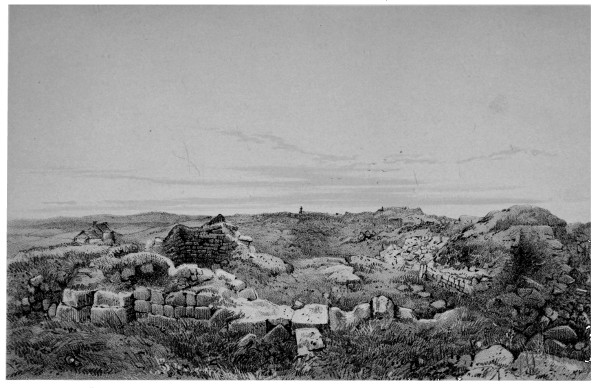
H. Burdon Richardson, Delt.John Storey, Lith. HOUSESTEADS (BORCOVICUS) FROM THE EAST. Printed by W Monkhouse, York
RUTS IN THE GATEWAY.
The Domitian way which led to it was narrow, the carriage-way seldom exceeding ten feet in width. The streets of the city itself are paved with large irregular pieces of lava, joined neatly together, in which the chariot wheels have worn ruts, still discernible; in some places they are an inch and a half deep, and in narrow streets follow one track.... In most places, the streets are so narrow, that they may be crossed at one stride; where they are wider, a raised stepping-stone has been placed in the centre of the crossing. This, though in the middle of the carriage-way, did not much inconvenience those who drove about in the biga, or two-horsed chariot, because the width of these streets being only sufficient to admit the carriage, the wheels passed freely in the spaces left between the curb on either side, and the stone in the centre.[104]
The stone in the centre of the doorway would not be a greater impediment than the stepping stones in the streets of Pompeii.
The remains of the gateways of Borcovicus shew that in plan and construction they must have resembled the Roman Gateway which, under the name of the ‘Porta nera,’ is preserved entire at Treves, AUGUSTA TREVIRORUM, once the seat of government of the Western Empire.
In examining this and other Roman camps, the spectator will, perhaps, be struck with the narrowness of the streets, and the very small capacity of the the dwellings. It is well to recollect that in their encampments the Romans studiously avoided occupying a larger space than was absolutely necessary. 222Gibbon observes that a modern army would present to the enemy a front three times as extended as a Roman one of the same force. In the field, ten men were apportioned to a tent, ten feet square;[105] a similar proportion would without doubt be followed in the stationary camp.
BORCOVICUS.
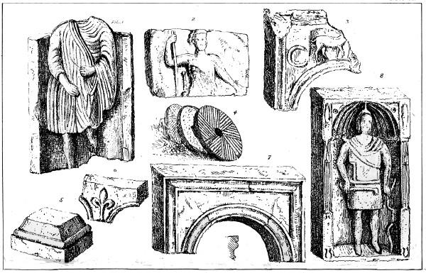
It is not easy to ascertain the precise character of the dwellings of the soldiers; the more perfect of the ruins in this and other forts, induce the belief that they were dark, bare, and cheerless. The roofs were probably formed of free-stone slate. Several thin slabs of this kind, with nail-holes in them, as well as some of the nails themselves, have been found in this and other stations.[106] On Plate XIII, figs. 1, 7, are drawn some door or window heads, found here; these most likely belonged to buildings of a superior class. The entrance into a chamber at Habitancum, recently excavated, was found to be only fourteen inches wide; it was rudely ‘stepped over’ at the top. Fragments of a sort of window glass are frequently found in some of the stations; this would probably be a rare luxury.[107]
THE CHAMBERS OF THE STATION.
At Housesteads, two or three of the ruined chambers 223will, above the rest, attract the attention of the visitor. Near the centre of the northern division is one which is seventy feet long and eight broad; it must have been a place of public concourse. In the front of it is a kiln which has probably been used for drying corn; near the southern gateway is another which was nearly destroyed in the endeavour made to extricate a cow which had fallen into it, and, in struggling to relieve herself, had thrust her head and neck into the flue. The Romans seem to have kiln-dried their corn at the close of the harvest; it would not have been safe to stack it in the open fields. They would the more readily do this, as it is still by no means unusual, in the central and southern parts of Europe, to thrash the corn at the close of harvest on the field where it grew.
Three hypocausts have been found here, two within the station, and another to the east of it, on the Knag-burn; the flues of the latter were full of soot; very slight traces of any of them now remain.
In this and most other stations, writes Hodgson, ‘there are found considerable quantities of limestone, having partly the character of stalagmite, and partly that of such cellular stone as forms about the mouths of petrifying wells. Some of it is in amorphous lumps; but the greatest part of it has been either sawn into rectangular pieces, or formed in a fluid state in moulds.’ They are probably artificial; at Habitancum, where this calcareous substance is abundant, it seems to have acquired its porosity by being mixed with straw. The use to which it has 224been applied is by no means obvious. Hodgson thought that it had been inserted in the side walls of the hypocausts, to allow heat to arise from below without smoke. This is doubtful. At Habitancum, the blocks, I am told, have been used as ordinary stones. In the construction of the Pharos at Dover, (where building stone is scarce) the calcareous composition has been largely used. Why it should have been employed at Habitancum, and other places, where free-stone is abundant, does not appear.
BORCOVICUS
The suburbs of Borcovicus have been very extensive, the ruins of them distinctly appearing on the east, south, and west sides of the station. A little to the south of it, and stretching westward, the ground has been thrown up in long terraced lines, a mode of cultivation much practised in Italy and in the east. Similar terraces, more feebly developed, appear at Bradley; I have seen them very distinctly marked on the banks of the Rede-water, Old Carlisle and other places.
A well, cased with Roman masonry, is in front of the shepherd’s house, south of the station; a spring, yielding excellent water, is at the bottom of the same field; the Knag-burn washes the station on its eastern side, and there is ‘a fine well under the high basaltic cliff’ on which the northern wall of the station stands, ‘which is still well walled round,’ and has occasionally been used as a bath. None has been discovered within the station itself.
PLATE XI
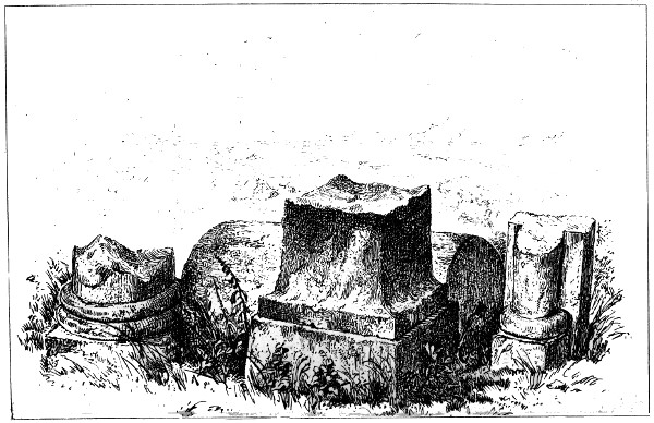
Broken Columns, Borcovicus
PLATE XII
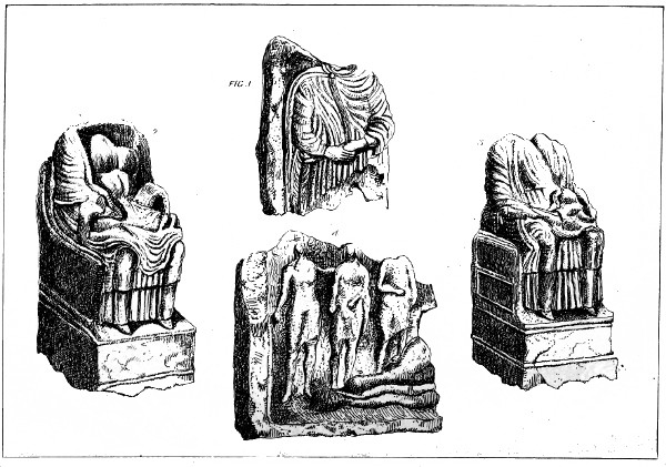
Sculpted Figures, Borcovicus
PLATE XIII
Sculpted Figures, etc.
ARCHITECTURAL REMAINS.
In the valley below is a small sandstone ridge, called Chapel-hill, from the idea that a temple stood 225upon it. Two fine altars have been found here.[108] The ruins that contained the Mithraic antiquities, to which reference will be made afterwards, stood a little to the west of this hill. All traces of the small, dark temple, where the horrid mysteries of the god were performed, are now nearly obliterated.
The fragments of columns which are engraved in Plate XI, enable us to imagine the original grandeur of the place.[109] With some of the certainty with which a comparative anatomist decides upon the character and habits of an animal, from an inspection of a fragment of its osseous system, an architect determines the size and style of a building from an examination of some of its parts. Thus, the circular column, of which one of the stones (Plate XI.) that now lies in the valley below the station, has formed a part, was probably not less than twenty feet high; how imposing must the entire temple have been!
Plates XII and XIII exhibit several of the carved figures which formerly lay in confusion among the ruins of the station. They are interesting, as exhibiting the state of the arts in Britain at that time, the mode of dress adopted by the Romans, and the high degree of attention which they paid to the decoration of their stations. Roman art in Britain has surely been rated too low.
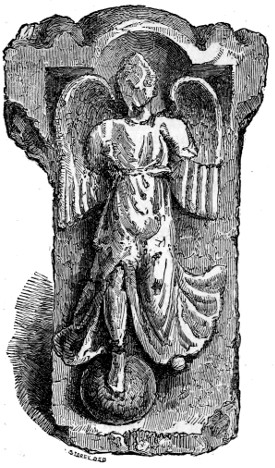
226The figure introduced on this page was found here. It represents one of old Rome’s most favourite deities,—Victory, careering, with outstretched wings, over the globe. How strong must the passion for conquest have been in the breast of a people, who, though nurtured in a southern climate, braved for more than three centuries, the fogs, and storms, and desolation of this wild region! Wherever the winged goddess led, they followed, and, most pertinaciously too, maintained their ground. But, there is a tide in the affairs of men.
A Roman poet, in the fulness of his heart, sang—
Urbs oritur (quis tunc hoc ulli credere posset?)
Victorem terris impositura pedem.
Cuncta regas: et sis magno sub Cæsare semper
Sæpe etiam plures nominis hujus habe.
Et quoties steteris domito sublimis in orbe,
Omnia sint humeris inferiora tuis.
How different the strains which, in a distant age, 227and in another clime, were to flow from the lyre of a brother bard, and how appropriate to the present condition of the deserted Borcovicus!—
Where is Rome?
She lives but in the tale of other times;
Her proud pavilions are the hermit’s home,
And her long colonnades, her public walks
Now faintly echo to the pilgrim’s feet,
Who comes to muse in solitude, and trace,
Through the rank moss revealed, her honoured dust.
That Housesteads is the Borcovicus of the empire, appears plain from the numerous inscriptions that allude to the first cohort of the Tungrians, which, according to the Notitia, was quartered there. One of these inscriptions is shewn on page 63; another, a sepulchral stone, is here presented. The figure on the top of the slab I take to be a rabbit, and suspect that it had some reference to the worship of the obscene god, Priapus. The inscription is usually read in the following manner, though, perhaps, ordinario 228might with equal propriety be read ordinato:—
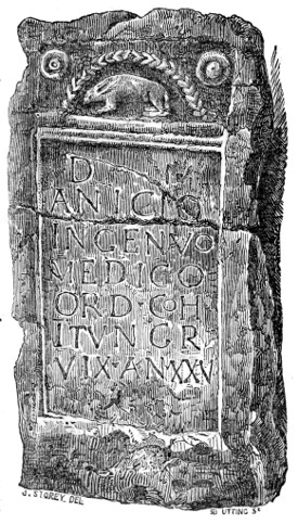
D[IIS] M[ANIBVS]
ANICIO
INGENVO
MEDICO
ORDI[NARIO] COH[ORTIS]
PRIMÆ TVNGR[ORVM]
VIX[IT] AN[NIS] XXV
Sacred to the gods of the shades below.
To Anicius
Ingenuus,
physician
in ordinary, of cohort
the first of the Tungrians.
He lived twenty-five years.
From an inscription found at Castlecary, it appears that this cohort of Tungrians built one thousand paces of the Antonine Wall in Scotland. They were from about Tongres, on the banks of the Mæse, in Belgic Gaul. Their rank, as a milliary cohort, conferred on them the dangerous honour of advancing in the van of the army to battle, and their acknowledged valour probably procured for them the appointment to this exposed and dangerous post.
THE NAME ASCERTAINED.
The etymology of Borcovicus is easy. A high hill to the south of the station is called Borcum or Barcomb, a neighbouring stream is designated Bardon-burn, and a village near its confluence with the Tyne, Bardon-mill. Bar, in Celtic, means a height, and probably forms the root of all these names; the termination, vicus, is a Latin word, signifying a village.
The stone used in the inside of the walls of the station, and for other ordinary purposes, has been quarried out of the cliffs in the sandstone ridge, along which the present military road passes. 'The altars, columns, and quoins, and much of the ashlar work, have been taken from a stratum of freestone on the north side of the Wall, and similar to that in 229which the recesses, called the King and Queen’s Caves, on the south side of Broomlee-lough, are formed.'[110]
THE VALLUM COMMANDED BY THE CRAGS.
Again taking the Wall as our guide, we will pursue our course westward. For the greater part of the way along the high ground, the Wall is in a sufficiently good state of preservation to make it a varied and interesting study; it not unfrequently exhibits five, six, and even seven courses of facing-stones. The Northumbrian lakes also lend a charm to the scene. Though appearing in native simplicity and rude grandeur, they will not on that account be less appreciated by men of taste. The Vallum is generally very boldly developed, and runs for several miles in the valley below, completely commanded by the hill on which the Wall stands, as is shewn in the section, Plate IV. This fact is surely fatal to the theory of its having been erected to withstand the brunt of a northern foe. It would have been impolitic to allow the enemy to occupy these heights even as a post of observation. It is true, that the Vallum is occasionally commanded by the rising ground on the south: opposite Sewingshields it is so, and opposite Hot-bank, a little to the west of where we now are, it is overlooked on both sides. This difficulty is not a very formidable one. The engineer of the Barrier has drawn the Vallum chiefly in straight lines from one point to another, and has not thought it necessary to guard with excessive jealousy every little 230rising ground to the south; he never, however, departs from his course to go round the north of a hill, as he does to go round the south of that one near Halton-chesters. The cases, moreover, in which the Vallum is exposed to observation from the south, are very few. Horsley’s own testimony upon this point is decided. He writes—
It must be owned, that the southern prospect of Hadrian’s work, and the defence on that side, is generally better than on the north; whereas the northern prospect and defence have been principally, or only taken care of in the Wall of Severus.[111]
RAPISHAW-GAP.
After passing a mile-castle we come to a depression in the ridge of basalt, that places us opposite the west end of Broomlee-lough; the crag on the west side of this slack is called Cuddy’s-crag. A little farther on, we reach a more extensive pass, called Rapishaw-gap; a road passes through it under the same circumstances as that through Busy-gap, a little above the bottom of the valley. The traveller may here with advantage go to the north of the Wall, in order to examine the geological character of the cliffs he has passed; they are seen ‘to rise in rude and pillared majesty.’
Regaining the high grounds, the Wall for a short space is found to possess less than its usual interest; the ground on the east side of the Bradley estate was formerly common, and the object of our study was every man’s prey. Other objects of inquiry, 231however, abundantly relieve the attention. Langley castle, on the south bank of the Tyne, is in sight, and during our western journey will long continue to be so. It is a square building strengthened by rectangular towers at the corners. Formerly a seat of the Percys, it became afterwards the property of the Radcliffes. It passed, on the rebellion of 1715, along with the other possessions of the earl of Derwentwater, into the hands of the commissioners of Greenwich Hospital, who at present retain it. Destroyed by fire at an early period, it has never been repaired; its masonry is notwithstanding in excellent preservation. On a clear day the singularly strong tongue of land on which are the ruins of Staward-le-peel, may also be discerned to the south. But, more to our present purpose, the high, brown hill of Borcum, from which the Romans obtained much of the stone used in the construction of this part of the Wall, is in the foreground. |ANCIENT QUARRY| An interesting discovery was made here in 1837, to which subsequent reference will be made. On opening an ancient quarry on the top of it, near the ‘longstone,’ a workman found a small copper vessel, containing a large number of Roman coins; four of these were of the time of Hadrian, and all the rest, of previous reigns. Those of Trajan and Hadrian were as fresh as if new from the die. The conclusion is natural, that the quarry had been last wrought in the time of Hadrian, the Wall itself being possibly of the same date. An extensive earthen camp is on the summit of the hill, probably raised by the soldiers who were engaged in quarrying the rock.
232Greenlee-lough is to the north; on its western margin is a modern structure, Bonny-rig, the property of sir Edward Blackett.
Proceeding westward, the Wall again rises into notice. ‘Much of it remains of very various thicknesses, the whole of the perpendicular outsets and insets being on the south side.’
HADRIAN SLAB.
On the tail of the crag on which we now are, the farm-house of Bradley stands. Built up in the doorway of its old kitchen, was a stone, now at Matfen, bearing the fragment of an inscription. Another fractured slab, formerly in the possession of the ‘judicious’ Warburton, and now at Durham, when joined to it, gives an inscription precisely similar to one immediately to be noticed, with the exception of a letter or two in the line of the fracture. The fragments, doubtless, as Hodgson conjectures, formed one stone, deposited in the foundation of some castellum in this neighbourhood, as a memorial of its erection by Hadrian. The wood-cut annexed has been prepared from drawings carefully made of the two portions in their separate localities.
233
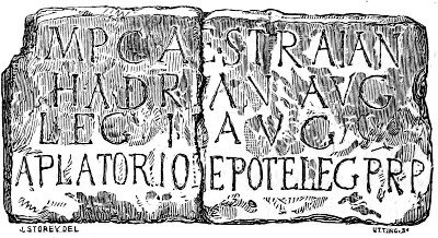
BRADLEY HALL.
Once, at least, since the days of Hadrian, this central region of the Wall has been honoured with the presence of royalty. Hodgson says,—
On the authority of documents in Rymer, Prynne, and the Calender of Patent Rolls, I find Edward the First testing records in the presence of several great officers of state, at Lanchester, on Aug. 10; at Corbridge, Aug. 14; at Newburgh, Aug. 28, 30, 31, and Sep. 4; at Bradley ‘in Marchia Scotiæ,’ Sep. 6 and 7; at Haltwhistle on the 11th, and at Thirlwall on the 20th of the same month; and at Lanercost on Oct. 4, A.D. 1306, at which last house he continued all winter. The Bradley here mentioned is probably Bradley-hall, on the right bank of Craglough-burn, and a little south both of Vallum and Wall, not the farm-house of Bradley, which is between the two barriers.—Northd. II. iii. 288.
The exigencies of war have again and again drawn to this secluded spot the mightiest potentates of earth; as yet this imperial ground has not been trodden by the feet of Majesty, attracted by the sweet allurements of peace.
On the margin of the military road, opposite to us, is the only Inn in the district, which is known by no other name than that of Twice Brewed. Before the construction of the Railway it was much resorted to by the carriers who conducted the traffic between the eastern and western portions of the island. As many as fifty horses and about twenty men would be put up here for the night. Now, it is nearly forsaken. Hutton took up his abode here on a carrier’s night. The difficulty he had in procuring an exclusive bed was compensated by the amusement of observing the carriers at their meal—he soon perceived 234that they had ‘no barricade in the throat; and became convinced that eating was the chief end of man!’
MILKING-GAP.
The next break in the basaltic ridge, is the Milking-gap. As we approach it, Crag-lough is seen laving the base of the perpendicular cliff along which the Wall runs. In order to take the high ground, westward of the gap, the Wall here turns at a considerable angle. In this valley, the north fosse again comes to the help of the structure. In front of the farm-house, called Hot-bank, are distinct traces of a mile-castle. In taking up its foundations, the slab, of which the annexed drawing is a faithful copy, was found, which would seem to be a tablet precisely similar to that which is formed by the junction of the two fragments referred to above.
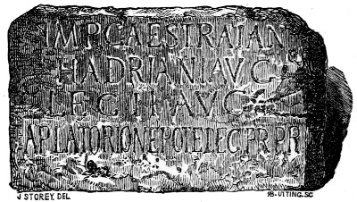
IMP[ERATORIS] CAES[ARIS] TRAIAN[I].
HADRIANI AVG[VSTI]
LEG[IO] SECVNDA AVG[VSTA]
AVLO PLATORIO NEPOTE LEG[ATO] PR[O]PR[ÆTORE.]
Of the Emperor Cæsar Trajanus
Hadrianus Augustus,
The second legion, styled the August,
Aulus Platorius Nepos, being legate and proprætor.
235Of all the inscriptions discovered in Britain, Hodgson pronounces this to be of the greatest historical importance, inasmuch as it leads to the true reading of several fragments of similar inscriptions throwing|MILKING-GAP INSCRIPTION.| light upon the authorship of the Wall. One of these was known to Horsley, and seems to have puzzled that great antiquary. It and other fragments which have since been found in different mile-castles, tend to produce the conviction, that the mile-castles, (which are on the line of the Wall, ascribed to Severus,) were built by Hadrian. The simplicity of the inscription will strike the classical reader, who will not fail also to observe the peculiarity of the name of the emperor being in the genitive case.
Although the station of Vindolana lies considerably to the south of the lines of the Barrier, it is ranked by the Notitia among the stations per lineam valli, and as such, must be examined by us in our mural peregrination. Leaving Milking-gap with this view, and crossing the low grounds to the south of the Wall, the Vallum is observed, contrary to its usual tendency, making two rapid curves, something in the form of the letter S, to avoid, apparently, the swellings of the contiguous marsh. At High-shields, a cottage on the little ridge south of the turnpike-road, the station comes into view. It stands upon a partially detached eminence, surrounded, though not so closely as to be commanded, by hills of superior elevation. On all sides, except the western, it is naturally defended, whilst the summits of the surrounding heights afford it a degree of shelter 236which would be peculiarly grateful to the natives of southern Europe. The Chineley-burn flows past it, and the situation is altogether one of peculiar beauty. In modern times, the place has been variously designated Little Chesters, the Bowers, and Chesterholm.
VINDOLANA.
VINDOLANA.—As this station is detached from the Wall, and lies upon the line of the ancient road which ran from Cilurnum to Magna, it is not improbable that it was one of Agricola’s forts. The road which connected it with the Wall may yet be distinctly traced between High Shields and the farm-house of Chesterholm.
The walls, ditches, and gateways of the station are all discernible. The northern gateway would be the one chiefly used by the garrison, as it opens directly upon the Great Military Way. An examination of the western gateway, some years ago, led to the belief that it had been walled up at an early period; this is the most exposed side of the camp. A portion of the wall of the station near the north-east corner, when cleared by its late owner, Mr. Hedley, stood twelve courses high. In this case, as in many others, the researches of the antiquary have only facilitated the operations of the destroyer; much of it has since been removed. The size of the stones, which is considerable in the foundation course, gradually diminishes upwards.
CHESTERHOLM.
At least two buildings provided with hypocausts, have been discovered here. One of these stood about fifty yards beyond the western rampart, and 237when discovered, contained a square apartment, vaulted above. Some of the vaulting-stones are still preserved at Chesterholm; they are grooved near the lower extremity, apparently to allow of the joints being strengthened by the insertion between them of keys of slate or wood. The remains of this building were more complete when Hodgson wrote the following paragraph than at present:—
The pillars of the hypocaust are still very black with fire and soot; and people say that the Bowers, from the Roman age till within the last century, was the elysium of a colony of fairies; and this ruined bath, the kitchen to one of their palaces, of which the soot among the stones was undeniable evidence; and confident belief affirmed, that long passages led from this laboratory of savoury messes to subterranean halls that ever echoed to the festivities and music of the Queen of the Bowers, and her aërial court.
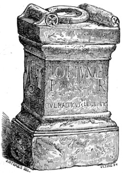
The other hypocaust was partially explored by Warburton in 1717, but more fully by the rev. Ant. Hedley in 1831. It stood within the area of the camp not far from the eastern gateway. In its ruins, Warburton found the fine altar to Fortune, here engraved. It is now preserved in the Library of the Dean and Chapter at Durham, the ‘judicious’ antiquary not having been able to obtain 238his price for it of my lord Oxford.[112] Here also Mr. Hedley discovered the three noble altars which are still preserved at Chesterholm. The pillars which supported the floor of the hypocausts were of different shapes and diameters; some of them were portions of square columns, as in the annexed example, some circular, like the balusters of stairs, as may be seen by the specimens of them in the garden at Chesterholm. The Romans themselves, Hodgson remarks, seem to have treated the fallen works of their predecessors here with very little ceremony, when they cut down the handsome columns of halls and temples into pillars for sooty hypocausts.
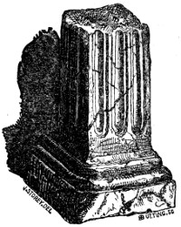
About a furlong west of the camp is a copious spring, from which the water was taken by a channel formed of large stones into the station. The water still, in some measure, follows its ancient track, as the appearance of the herbage shews, and pours itself, by a covered passage, into the Chineley-burn on the opposite side.
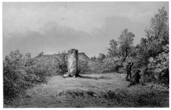
H. Burdon Richardson, Delt.John Storey, Lith. MILE STONE AT CHESTERHOLM.
In the vicinity of the camp is an object of peculiar interest. On the line of the ancient Roman road which skirts its northern rampart, stands a mile-stone at the spot where the soldiers of Agricola or 239Hadrian placed it. The opposite lithograph shews it in the foreground; the camp is in the distance. It is upwards of six feet high, and is nearly two feet in diameter. There are traces of an inscription on its western face, but scarcely a letter can now be deciphered.|ROMAN MILE-STONE.| Another mile-stone formerly stood to the west of this, but it was removed and split up by its tasteless owner, into two gate-posts. Horsley says that it bore the inscription—
BONO REIPVBLICÆ NATO.
To one born for the good of the republic—
an inscription which, supposing it to be perfect, though this is a little doubtful, is happily contrived to be complimentary to each successive emperor. The Romans, with wise policy, paid great attention to their roads; the stones which they erected at every mile were generally inscribed with the name of the consul or emperor under whose auspices they were made. Horsley mentions another mile-stone, which was to the east of the present one.
Close by the mile-stone is a tumulus of considerable size.
In the house and grounds of the late Mr. Hedley, are preserved some very valuable antiquarian remains. A very fine altar to Jupiter is reserved for subsequent description. Another, whose focus is reddened by the action of fire, is here introduced on account of the evidence which it affords, in corroboration of the conjecture of Horsley, that Little Chesters was the Vindolana of the Romans, where, 240according to the Notitia, the fourth cohort of the Gauls was stationed.
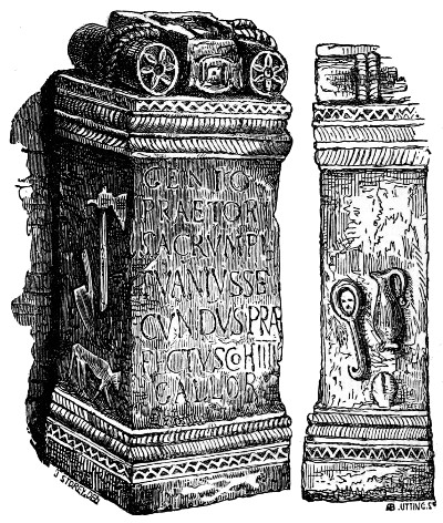
GENIO PRÆTORI[I] SACRVM PI TVANIVS SE CVNDVS PRÆ FECTVS COH[ORTIS] IV GALLOR[VM]
To the genius of the Prætorium sacred; Pi- tuanius Se- cundus præ- fect of the fourth cohort of the Gauls, erects this.
Several other inscriptions by the fourth cohort of the Gauls have been found here since the time of Horsley.
The altar to Fortune, given in a previous page, shews us that at least a detachment of the sixth 241legion had, at some period, its abode here. |THE TWENTIETH LEGION.| A stone,
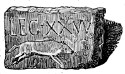
preserved at the place, and of which an engraving is here given, bears testimony to the presence of the twentieth legion also, which was surnamed V[ALENS] V[ICTRIX], ‘the valiant and victorious’, and of which the symbol was a boar. This legion was first sent over to Britain by Claudius, and remained in it until the island was abandoned by the Romans. Horsley conceives that this legion was concerned in the erection of the Vallum, though, he adds, we have no inscriptions to prove it. He suspects that it was no-way concerned in building the Wall, because, among all the centurial inscriptions which had come under his notice, not one mentioned this legion, or any cohort belonging to it. The discovery, since the publication of the Britannia Romana, of this and other memorials to be noticed as we proceed, renders
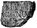
it probable that the twentieth legion was engaged upon both the Wall and the Vallum; and as, according to Horsley, ‘it is evident that this legion was at Chester in the year 154,’ where it long continued, the probability is strengthened, that the Wall, as well as the Vallum, was built before that period. A fragment of an inscription, represented above, bears direct reference to Hadrian. The Milking-gap slab, to which it has a very close resemblance, enables us to supply the parts that are 242wanting. The only difference seems to be, that the emperor’s name is in the dative case instead of the genitive as in the other example.
IMP CAES TRAIAN
HADRIANO AVG P P
LEG II AVG
A PLATORIO NEPOTE LEG PR PR.
The cottage which Mr. Hedley erected for his own residence is, with the exception of the quoins,
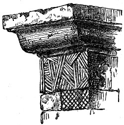
entirely formed of stones procured from the station. In addition to the altars which stand in front of the house, several objects of considerable interest are built up in the covered passage which leads from the kitchen to the burn; among them is a range of Roman coping-stones, of the form shewn in the cut. The ‘broaching’ of the stones has been alluded to previously.
Near the stables attached to the house, is a Roman altar converted into a swine-trough; the figure on its side seems to have been intended for an eagle, the emblem of the imperial Jove. A foretaste this of the day when every idol shall be cast to the moles and to the bats. May it speedily arrive!
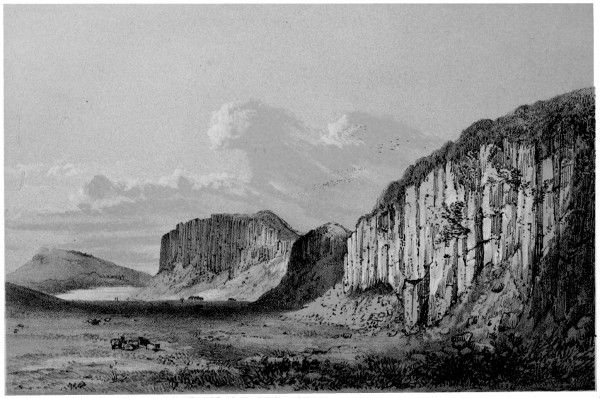
John Storey, Del. et Lith. THE CRAGS, WEST OF CRAG LOUGH.
VINDOLANA
The probable meaning of the word Vindolana, is ‘the hill of arms;’ vin, with slight variations of pronunciation, signifying, in all the Celtic dialects, a height; and lann, in the Gaelic, weapons. The name well accords with those common in Ossian’s poems.