PART III. LOCAL DESCRIPTION OF THE WORKS. (continued 3)
Reading edition
243Rejoining the Wall at Milking-gap, and continuing our course westward, we soon arrive at a conspicuous gap, on the Steel-rig grounds. The Wall on the eastern declivity of this pass may be studied to great advantage. The courses are laid parallel to the horizon; the mortar of each course of the interior seems to have been smoothed over before the superincumbent mass was added. In order to give the in-door antiquary an idea of its condition, a drawing of it is here introduced.
PEEL-CRAG.
Mounting another hill, and again descending into the valley, we find another gap, in which the remains of a mile-castle will be noticed, from which it has received the name of the Castle-nick. A little farther removed is Peel-crag, one of the most precipitous faces which the Wall has had to traverse. The military way ingeniously avoids the sudden descent by winding round the southern projections of the rock. After passing a cottage, called the Peel, a modern road is encountered which leads to Keilder, and so into Scotland; in its progress northwards, however, it soon degenerates into a mere track. As this pass is more than usually open, the fosse again appears surmounted by a mound on its northern margin; the earth-works are strongly marked, but the Wall is gone.
The lithographic view represents the northern aspect of the crags, as they appear here.
On the western side of this, sheltered by a few trees, is the farm-house of Steel-rig. Attaining the next elevation—Winshields-crag—we are on ground 244reputed to be the highest between the two seas; a turf cairn has been erected on it for the purposes of the ordnance survey. From this lofty summit, the vessels navigating the Solway may easily be descried.
BLOODY-GAP.
Proceeding in the same direction, we reach another gap of wide dimensions, but very steep on both declivities. Here the Wall has been provided with a ditch, strengthened, as usual in dangerous situations, with a rampart on its outer margin. If the local vocabulary does not furnish this pass with a name (and I have not been able to find that it does), Bloody-gap, from the following circumstance, well befits it. Nearly direct north from it, is a rising ridge of ground, called Scotch-coulthard. When the moss-troopers, who abounded in these parts, succeeded in safely reaching it, their pursuers commonly considered farther chase useless. Between the Wall and this point of safety, therefore, the race and the conflict were necessarily of the most desperate character; that many deadly conflicts have taken place, is evidenced by the numerous skeletons which are turned up in draining the ground.
A lonely cottage, upon an exposed part of the ridge, is called Shield-on-the-Wall.
Near the modern military way, two large stones, called ‘the mare and foal,’ are standing. In Armstrong’s map of Northumberland, three are marked; they are probably remains of a Druidical circle.
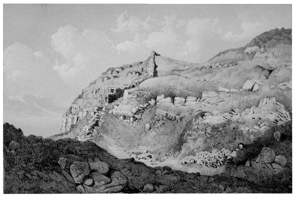
H. Burdon Richardson, Delt.John Storey, Lith. THE WALL AT STEEL-RIG. Printed by W. Monkhouse, York
ANCIENT TRADITIONS.
Shortly afterwards we come to a gap of very bold proportions. Popular faith asserts it to have been the abode of evil spirits, and it is known by the ominous name of Bogle-hole. The sides of the 245gap are steep; on the western declivity the courses of the Wall are for the most part conformable to the ground, but they are stayed up by occasional steps parallel to the horizon. In the valley, to the south, the Vallum is seen bending up towards the Wall, apparently to assist in defending the pass; it would not have done so, had it been an independent fortification. The vicinity of Bogle-hole seems a fitting place for introducing the following passage from Procopius, a writer of the fifth century. We can readily conceive that at a period when the inroads of the Caledonians were still fresh in the memory of the inhabitants, the country north of the Wall would be regarded with superstitious dread. Doubtless, many who passed the boundary, found, to their cost, that in this region lay the pathway to the world of spirits:—
Moreover, in this isle of Brittia, men of ancient time built a long wall, cutting off a great portion of it: for the soil, and the man, and all other things, are not alike on both sides; for on the eastern (southern) side of the Wall, there is a wholesomeness of air in conformity with the seasons, moderately warm in summer, and cool in winter. Many men inhabit here, living much as other men. The trees, with their appropriate fruits, flourish in season, and their corn lands are as productive as others; and the district appears sufficiently fertilized by streams. But on the western (northern) side all is different, insomuch indeed, that it would be impossible for a man to live there, even half an hour. Vipers and serpents innumerable, with all other kinds of wild beasts, infest that place; and, what is most strange, the natives affirm, that if any one, passing the Wall, should proceed to the other side, he would die immediately, unable to endure the unwholesomeness of the atmosphere. Death also, attacking such beasts as go thither, forthwith destroys them.... They 246say that the souls of men departed are always conducted to this place; but in what manner I will explain immediately, having frequently heard it from men of that region relating it most seriously, although I would rather ascribe their asseverations to a certain dreamy faculty which possesses them.—Giles’s Ancient Britons, I. 404.
CAW-GAP.
The next defile is Caw-gap; some ruined cottages, formed of Wall-stones, stand in it. The extreme jealousy with which the Romans defended an exposed situation is well shewn here. The fosse, which guards the pass through the low ground, is discontinued on the western side as soon as the Wall attains a sufficient elevation, but upon the the ground drooping, though only for the space of a few yards, it re-appears for that short distance.
A road runs through this pass to the north, which soon becomes a mere track. It passes a solitary house, called Burn Deviot, nearly due north from the gap, which was long the resort of smugglers and sheep-stealers. The memory of its last tenants, Nell Nichol and her two daughters, who were a pest to the country, is still fresh in the district. Though many years have elapsed since any one occupied the dwelling, lights are said often to be seen at the windows at night, visible tokens of the presence of the spirits of the murdered children of Nell’s daughters.
CAWFIELDS CRAGS.
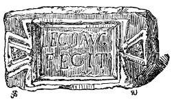
The crags along which we soon find ourselves to be proceeding, possess a perpendicular elevation of nearly five hundred feet above the plains below. Passing another small gap, called the Thorny Doors, we come to a tract of Wall in an excellent state 247of preservation. The lower courses have lately been freed from the rubbish which for centuries has covered them, and the fallen stones replaced in their proper order. The whole face of the Wall has a remarkably fresh appearance, and nowhere can the tooling of the stones be examined with more advantage. Amongst the fallen stones, one was lately found which furnishes us with additional evidence, that the twentieth legion was engaged in the erection of this part of the Wall. It
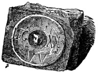
is preserved amongst the antiquities at Chesters, and is represented in the adjoining cut. This sculpture cannot have been derived from the Vallum, in the construction of which, in the time of Hadrian, the twentieth legion is acknowledged to have been employed; for the Vallum is here distant more than three hundred yards from the Wall. The reader will of course perceive the bearing which this fact has upon the question of the contemporaneous origin of the two structures, and the construction of the Wall, as well as the Vallum, by Hadrian.
While the antiquary is eagerly scrutinizing indentations in stones which were chiselled sixteen centuries ago, his eye will occasionally rest upon the memorials of an antiquity so indefinite as to throw into the shade even his primeval records. Lepidodendra, and other fossils of the mill-stone-grit and coal series, are of occasional occurrence. Who shall tell 248when these giant plants flourished, how they were enveloped in their sandy bed, and how hardened into the flinty stone made use of by the Roman soldiers? Imagination reels at the questions suggested.
PILGRIMS'-GAP.
We are now arrived at the most perfect mile-castle remaining on the line, generally named, from the farm-house to the north of it, the Cawfields Castle. The gap which it guarded was denominated by the peripatetic party of 1849, in commemoration of their visit, the Pilgrims’-gap, a name which is beginning to be recognised by the inhabitants of the neighbourhood.
THE CAWFIELDS CASTELLUM.
Until recently, the castellum was nearly covered with its own ruins. Since the annexed drawing was taken, the rubbish has been entirely removed from the inside, as well as the out.
The building is a parallelogram, but the corners at its lower side are rounded off. It measures, inside, sixty-three feet from east to west, and forty-nine feet from north to south. The great Wall forms its northern side. The stones used in the construction of this building are of the same size and character as those employed in the Wall itself; the mortar has disappeared from between the courses of the facing-stones, but portions of lime are seen in the grout of the interior. In the western wall, nine courses of stones are standing. The side walls of the castle have not been tied to the great Wall, but have been brought close up to it, and the junction cemented with mortar.
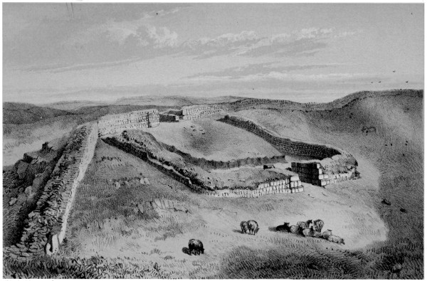
H. Burdon Richardson Delt.John Storey, Lith. MILE-CASTLE NEAR CAW-FIELDS Printed by W. Monkhouse York.
It is provided with a gateway of large dimensions, 249both on its northern and southern side. In Horsley’s day, it was a matter of doubt whether there was any opening through the Wall, excepting at the points where the Watling-street and the Maiden-way crossed it; the disinterment of this mile-castle sets the question at rest, and justifies us in believing that the passages at Busy-gap, Rapishaw-gap, and other places, are of Roman formation.
The gateways are formed of large slabs of rustic masonry, and to give them full development, the walls are thicker here than in other parts. The width of the wall at the lower gateway is nine feet three inches; at the upper, which was, of course, the more exposed, ten feet six inches. The opening of each gateway is ten feet. Two folding-doors have closed the entrance, which, when thrown back, have fallen into recesses prepared for them. Some of the pivot holes of the doors remain, which exhibit a circular chafing, and are slightly tinged with the oxide of iron. The security of the northern gateway did not entirely depend upon the solidity of its masonry, or the strength of its doors. It opens upon a sort of cliff, and the road from it does not lead directly away, but runs for a little distance under the Wall, so as to give an opportunity of more readily acting against an enemy.
The masonry of the whole building, but particularly of the gateways, is peculiarly fresh. The lines that have been lightly chiselled on some of the large rustic slabs of the gateways, in order to guide the workmen in correctly placing those above which 250project less than than the others, are still quite distinct. The stone is of a very durable nature, but it is difficult to conceive how such slender markings, particularly when in a horizontal position, could long resist the action of the weather. Were we to judge only from the appearance of the masonry, we might be led to suppose that the building had been enveloped in its own ruins not long after its erection—perhaps in that dreadful irruption of the Caledonians which brought Severus to this country—and that it was never afterwards repaired.
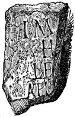
In clearing out the interior of this building, no traces of party-walls, of a substantial character at least, were found. It stands upon a slope of about one foot in five, and, towards the hanging side of it, the ground has been rendered horizontal by ‘made earth.’ Some fragments of gray slate, pierced for roofing, were found among the rubbish; it is therefore not improbable that a shed was laid against the southern wall for the protection of the soldiers. At about the elevation which the raised floor would reach, the Wall is, in one place, eaten away by the action of fire. Here, probably, was the hearth round which the shivering soldiers of the south clustered, to forget, in the recital of their country’s tales, the fierce Caledonians who prowled around them, or the still fiercer tempests, which all their valour and all their engineering skill could not exclude from their dwellings. With the exception of such sheds, or mere temporary erections, the whole building seems to have been open above. Two large fragments of funereal slabs 251were found in the castellum; one of them has been roughly shaped into a circular form, and is reddened by fire; the letters which remain are distinct and well formed. Has it been the hearth? The inscription has been erased from the other. Another stone of still greater interest was found here, furnishing additional evidence of the erection of the mile-castles by Hadrian. From the annexed cut, it will at once be perceived that it is a duplicate of the inscription, already described, in which the second legion endeavours to perpetuate its name, and those of its emperor, Hadrian, and Aulus Platorius Nepos, his legate. There cannot be a doubt that the castellum and the Wall were built at the same time, and by the same parties; if Hadrian therefore built the one, the other is erroneously ascribed to Severus.
Two small silver coins were found amongst the rubbish within the castellum, one of Vespasian, the other of Marcus Aurelius. Although their testimony is of a negative character, it will be observed, that it is not inconsistent with the idea, that the castle was erected in the time of Hadrian, and with the opinion already hazarded, that it was dismantled at an early period. There were also found large pieces of earthen-ware, chiefly of the coarser kinds, and fragments of millstones formed of lava, which shew that culinary operations were carried on within these cold, bare walls, and a solitary oyster-shell among 252the rubbish bore testimony to the attachment of the Romans to this article of luxury. The mile-castle is very nearly midway between the seas.
Besides the articles already enumerated, there were picked up within the castellum some large glass beads of somewhat singular appearance, (Plate VII., figs. 7, 8) and a fibula of brass. The whole of these relics are safely deposited in the collection of antiquities at Chesters. The interesting building is, happily, upon an estate belonging to John Clayton, esq.; the hand of the spoiler will therefore not be allowed to touch it.
About one hundred and fifty yards south of the castellum, is a spring of excellent water. Near it, about midway between the Vallum and the Wall, an altar to Apollo was lately discovered, which will afterwards be described.
TEMPORARY CAMP.
A road leads from the vicinity of the mile-castle to the town of Haltwhistle, in the sheltered valley of the Tyne, whither, should the shades of evening be approaching, the way-worn antiquary may be glad to bend his steps. At the point where the path joins the modern military road, a Roman camp will be observed. On the sides which are most exposed, double and triple lines of earth-works have been raised. The rock on the western face of the ground where the camp stands, has been wrought by the Romans for stones, and the camp has given them temporary protection. It was here that the inscription on the face of the rock, LEG. VI. V., was discovered in 1847, as already mentioned, page 81. The quarry, 253not being required for the use of the district, was shortly afterwards closed.
HALTWHISTLE.
The Castle-hill at Haltwhistle is, apparently, a diluvial deposit; ramparts, still quite distinct, run round the margin of its summit. Several peel-houses in the town and its vicinity, will interest the antiquary.[113]
To those who cherish the religious views of the early Anglican reformers, it will be interesting to remember, that this is the native district of Nicholas Ridley, bishop and martyr. Willimoteswick-castle, his reputed birth-place, is on the south bank of the Tyne, about three miles below Haltwhistle.[114]
HALTWHISTLE-BURN-HEAD.
254Rejoining the Wall, Haltwhistle-burn-head is the first object of interest that we meet with in our course westward. The burn, to which important reference will presently be made, is derived from the overflowings of Greenlee-lough. Between its source, and the gap by which it passes the ridge on which the Wall stands, it is called the Caw-burn; below that point it bears the name of Haltwhistle-burn.
As the width of the defile, and the passage of the stream, render this a weak point in the barrier, the two lines of fortification approach very near to each other; they afterwards again diverge.
Westward of Burn-head farm-house, the fosse is boldly developed, but the Wall is traceable only in the ruins of its foundation. As we proceed onwards to Great Chesters, the foundations of a mile-castle which has stood half to the north of the Wall, and half within it, may be, though not without careful scrutiny, observed. The tower which formerly stood at Portgate is the only other known example of a similar arrangement.
GREAT CHESTERS.
ÆSICA, or Great Chesters, is the tenth stationary camp on the line of the Wall. Its superficial contents are 3 acres, 35 poles. The ramparts and fosse are clearly defined. The southern gateway may be traced; it is nearer the eastern than the western side. A double rampart of earth seems to have given additional security to the western side, which, by situation, is the weakest. A vaulted room in the centre of the camp still answers very correctly to 255the description given of it in 1800 by Dr. Lingard, (quoted by Hodgson, II. iii. 203.)
It is 6½ feet square, and 5 feet high. It was descended by steps, and had, at the opposite end to its entrance, a sort of bench, raised on mason work, 2½ feet wide and high, and covered with a slab of stone. The roof consisted of six similar and contiguous arches of stone, each 15 inches broad. It had also one pillar. The floor had on it a great quantity of ashes, was flagged, and on raising one of the stones, a spring gushed out, which converted the vault into a well.
About one hundred and fifty yards south of the station, in a field which has for years been furrowed by the plough, the remains of a building of somewhat rude construction have just been discovered. Its floor, consisting, for the most part, of the usual compost, is nearly a foot thick. Further examination would probably disclose, in its vicinity, the foundations of numerous suburban buildings.
An ancient road leads from the southern gateway of the station to the great military way which ran from Cilurnum to Magna.
ÆSICA.
The station of Æsica, according to the Notitia, was about the year 430, garrisoned by the cohors prima Astorum.[115] Horsley (writing in 1731) observes, that no inscriptions had been found here mentioning the first cohort of the Asti, or any other cohort. In 1761, however, an inscription was dug up in this station, which is now deposited in the museum at Newcastle-upon-Tyne, recording that in the reign of Alexander 256Severus (200 years before the date of the Notitia) the ‘cohors secunda Asturum’ rebuilt a granary here which had fallen into decay from age—‘horreum vetustate conlabsum.’ It is to be observed that the spelling of ‘Asturum’ is similar to that of the inscription at Cilurnum, and we do not find that the second cohort, either of the Asti or Astures, is mentioned elsewhere as part of the Roman auxiliary forces in Britain.
Near the eastern gateway of the station there has been lately dug up a large mural tablet, shewn in the wood-cut, and bearing the following inscription:
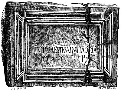
IMP. CÆS. TRAI[A]N. HADRIA NO AVG. P[ATRI] P[ATRIÆ]. To the emperor Cæsar Trajanus Hadria- nus Augustus, the father of his country.
It is not probable that this slab has been derived from the Vallum, which is upwards of a quarter of a mile from the station.[116] Why the upper part of the 257tablet was left blank does not appear; enough, however, has been inserted to support the theory, that Hadrian built the Wall. Although several of the stations were probably built before the Wall, and were quite independent of it, this can scarcely have been one of them; its position seems to indicate that it was called into existence in order to accommodate the mural garrison.
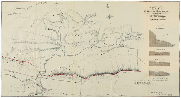
SURVEYED BY I. T. W. BELL 1860A. Reid’s Lithog. 117 Pilgrim St. Newcastle. Plan of AN ANCIENT WATER COURSE EXTENDING FROM SAUGHY BIG WASH POOL TO ÆSICA GREAT-CHESTERS.
ETYMOLOGY OF ÆSICA.
Celtic authorities all agree in tracing the name Æsica to a word signifying water. The propriety of such an appellation does not at first sight appear. The camp is far from either the eastern or western sea; no lake is visible from its ramparts; the only water which is near is the Haltwhistle-burn, a somewhat tiny stream. The low ground to the south has a fenny aspect, but the station itself stands high and dry, though upon a part of the mural ridge less elevated than usual. It is not improbable that it may have derived its name from an aqueduct which leads the water from the Greenlee-lough to the camp. As this water-course has hitherto escaped the notice of writers upon the Wall, and is a work of considerable interest, a somewhat detailed description of it may be allowable.
THE WATER-COURSE AT ÆSICA.
The camp, though not greatly elevated, stands higher than the ground, either north or south of it. The country to the north, though generally flat, is studded with numerous hills of moderate elevation. On the sides of some of these, about two-thirds up, may be noticed a line that reminds the spectator of the parallel roads in Glenroy and other 258places. On examination, it is found to be an artificial cutting, made with evident reference to the maintenance of the water level. The sections given in Plate XVI., shew its size and form. In some places the water stands in it yet; in others a mass of peat fills it; and very frequently, where the channel has been obliterated, its course is shewn by a line of rushes, which grow on the damp ground. Wherever the water-course can be distinctly discerned, it has been laid down in the accompanying plan by a green line; where the traces of it are lost, the line of the water level has been pursued, and is indicated by dots of the same colour.
THE WATER-COURSE.
The whole length of the water-course is six miles; the distance in a straight line is little more than two miles and a quarter. It takes its commencement at the Saughy-rig-washpool, which is formed by the occasional damming up of the Caw-burn, at about a mile from its exit from the Greenlee-lough. In the immediate vicinity of the burn, the side of the water-course next the rivulet which would be endangered by the overflowing of the natural stream, is made up with flat stones put in endwise, some of which still remain as shewn in the section at B, in the plan. In its course to the station, in order at once to preserve the level, and avoid the necessity of using forced embankments or stone aqueducts, it is taken along the sides of the moderately elevated hills which rise from the plain. So ingeniously is this done, that once only has it been necessary to cross a valley by an artificial mound of earth. This has been at a spot between the third and fourth mile of the water-course, and which is still known in the district by the name of Benks-bridge, though probably few of the inhabitants are aware of the evident origin of the term. Some ingenuity has been employed in fixing the site of this mound. It is placed in that part of the valley where there is a slight descent on each side of it; the drainage of the surface is thus provided for without the use of a culvert; the surface water on the west, naturally making for the Halt-whistle-burn, that on the east for the river Tipalt. The mound which has taken the water-course across the valley at Benks-bridge 259has entirely disappeared, having probably been absorbed, in the course of ages, by the mossy ground on which it stood. The whole fall of the water-course, reckoning from the Wash-pool to the bottom of the arched chamber in the centre of the station is thirty feet. This is distributed over its entire length in the way shewn in the following table:—
ft. in. m. f. c. ft. in.
Commencing at A 0 0 At 2 6 0½ 11 10 fall
m. f. c. 2 7 5 E 14 4 ”
0 0 6 B 2 10 fall. 3 0 0 21 6 ”
0 1 5 3 10 ” 3 0 3 23 7 ”
0 2 4 3 7 ” 3 0 6 23 5 ”
0 3 4½ 3 7 ” 3 1 3 29 10 ”
0 4 9 3 6 ” 3 3 5 25 3 ”
0 6 0 3 7 ” 3 5 0 North end, Benks-bridge. 25 4 ”
0 7 8½ 4 0 ” 3 5 0 South end, Do. 29 7 ”
1 0 6½ 4 1½ ” 4 1 5 29 9 ”
1 1 3½ 3 7 ” 4 5 8 29 11 ”
1 3 2½ 3 6 ” 5 3 5½ 28 6 ”
1 4 0 C 3 10 ” 5 4 4 28 11 ”
2 0 5 5 9 ” 5 5 5 29 0 ”
2 1 6½ 11 4 ” 6 0 0 Present bottom of arched chamber in centre of station. 30 4 ”
2 2 9½ D 11 2 ”
The nature of the ground threw considerable difficulties in the way of the engineer, which accounts for the exceedingly tortuous nature of the track pursued. It is indeed remarkable that without the aid of accurate levelling instruments, any one could be so fully assured that the requisite fall existed as to venture upon the task of its formation. The workmen in the execution of the design probably drew the water along with them as they proceeded. In one place, (G) they seem to have made too free with the fall, and after proceeding for some distance, (upwards of a furlong) have retraced their steps, and constructed the cutting at a higher level. In crossing the valleys, there is sometimes an unusual loss of fall. This is particularly the case at the third mile (E) where there is a difference in the level of the course, on the opposite side of the slack, of nearly ten feet. This valley is permeated by a streamlet, and to take the water 260across it at the level previously preserved, a stone aqueduct would have been necessary. Appearances seem to indicate that an easier plan was adopted. A dam being formed across the hanging side of the valley, the water of the course was allowed to deliver itself freely into it, and eventually rising after the manner of a mill-head to the level of the course on the western side, pursued its way as before. That this plan was the result of a change in the design of the architect seems evident, for on the eastern side of the valley a second cutting (E) has been made at a lower level than the other, apparently with the view of leading the water more gradually to the lower point.
Unfortunately all traces of the water-course are lost for some distance before approaching the station, so that it cannot be ascertained where it entered it, if it did so at all.
That some important object was gained by the formation of so long a cutting is undoubted, but what that object was is a perplexing question. It can scarcely be supposed that the garrison at Æsica were dependent for their daily supply of so important an article as water upon an open cutting outside the Barrier. The feeblest of their foes could, in an instant, cut off the provision. No doubt the country, for some distance north of the Wall, was held in subjection by the Roman forces, but when the Wall was built, and the station planned, such was not the case. The station itself is not destitute of water. A well, sunk some years ago, to the depth of twenty-four feet, yields to the tenants of the farm-house an unfailing supply. I am disposed to think that the water brought by the cutting was to give to the north rampart of the station the advantage of a wet ditch. By throwing an embankment across the depression on the north of the station, as it begins to slope down to the bed of the Haltwhistle-burn, a considerable body of water would lodge here. The station of Æsica was an important one. In a particularly wild district, at an unusual distance from the great lines of Roman communication, and close beside the great opening in the mural ridge, by which the waters of the Forest of Lowes effect a passage to the low grounds, it would be peculiarly exposed to the 261attacks of the enemy. Although somewhat elevated above the ground north of the Wall, it is not so much so as to be impregnable on that quarter. A body of water collected here to keep the enemy at a still greater distance might not be beneath the attention of the garrison. Any temporary interference with the aqueduct would in this case be productive of no inconvenience. The existence of a water-course on the enemy’s side of the Wall at Hunnum, which may have served a similar purpose, has already been noticed. At Bremenium, High Rochester, some guttered stones, covered with flags, were recently found lying in a direction which led to the supposition, that they brought water from some springs outside the station to the eastern moat.
In the Archæologia Æliana[117] is a plan and description of an ancient aqueduct, which brought water from some distant rivulets to the station at Lanchester. It consists of two branches, the longer of which is nearly four miles in extent. Earthen embankments, to preserve the level, are occasionally used in both of them, and, as they run over sandy ground, the bottom of them has been puddled. The two lines, after uniting, deliver their water into a reservoir outside the station, near to its south-west corner. That the water of this aqueduct cannot have been used for domestic purposes appears from what Hodgson, the author of the paper, adds—‘Several wells have, from time to time, been discovered here by labourers, on the outside of the walls, and there is a plentiful spring at a short distance from where the bath stood.’
Whatever may have been the object served, the water-course at Æsica is a striking memorial of the skill, forethought, and industry of the Roman garrisons. At the present day, in a highly civilized country, and after the enjoyment of a long period of internal peace, we are but beginning to see the necessity of bringing water from a distance into our large towns. An individual garrison, exposed to all the hazards of war, scrupled not, even fourteen or sixteen centuries 262ago, for some purpose which they thought important, to cut a water-course six miles long!
It is not a little remarkable too, that after the lapse of so long a period, the cutting should be distinctly visible through so large a portion of its track.
The view which is here taken of the object of the water-course is not given because it is absolutely satisfactory, but because it presents the fewest difficulties. We might have expected that if a miniature lake had been formed on the north of the station, some remains of the embankment necessary to confine its waters would appear; none are, however, to be observed. The soil, on being turned up, has not the black and sludgy aspect, which might be anticipated, but is of a yellow hue; the bottom of a pond at Wall-mill, which was drained within living memory, has, however, a precisely similar appearance.
To the south of Great Chesters is Wall-mill, near to which the burying ground of the station seems to have been. Brand observed here several remarkable barrows, and was shewn some of the graves which had been opened. ‘They consisted,’ he tells us, ‘of side stones set down into the earth, and covered at top with other larger stones.’ He took them to be very early Christian sepulchres; this is more than doubtful. The progress of agricultural improvement has obliterated all traces of the cemetery; to one, however, of its sepulchral monuments reference will afterwards be made.
The Romans systematically avoided intra-mural interments. The following is one of the laws of the Twelve Tables:
HOMINEM MORTUUM IN URBE NE SEPELITO NEVE URITO.
It is remarkable that at so early a period of the history 263of the republic, attention should have been turned to this subject, and that in a digest of legislation so brief as that referred to, this should form one of the enactments.
COCK-MOUNT-HILL.
Shortly after leaving Æsica, the crags again appear, and the Wall ascends the heights. At Cock-mount-hill, about a quarter of a mile forward, the Murus is four or five feet high. On the Ollalee ground, it is six and seven feet high, and shews on the north, nine courses of facing-stones; at another place, ten courses appear, and the height is six feet four inches.[118] The earth-works are seen in the valley below, covered with the whin, called by botanists, Genista Anglica. The continuous sandstone ridge is deeply scarred with ancient quarries.[119] Here the view is most extensive, Skiddaw, Crossfell, and other celebrated summits, shewing themselves conspicuously on the south, and Burnswark, a peculiar flat-topped eminence, and several more distant hills, on the north. A truncated pyramid of stones and earth, used by the ordnance surveyors,[120] has been left upon the elevated ridge, called Mucklebank-crag.
WALLTOWN-CRAGS.
The next defile that we reach is a very wide one, and is denominated Walltown crags. Walltown consists of a single house, which, though now occupied by the tenant of the farm, bears marks of having formerly been a place of strength, and the residence of persons of consideration. Ridley the 264Martyr refers with much affection in his valedictory letter to his brother who resided here:—
Farewell, my dearly beloved brother John Ridley of the Waltoune, and you my gentle and loving sister, Elizabeth, whom, besides the natural league of amity, your tender love, which you were said ever to bear towards me above the rest of your brethren, doth bind me to love. My mind was to have acknowledged this your loving affection, and to have requited it with deeds, and not with words alone. Your daughter Elizabeth I bid farewell, whom I love for the meek and gentle spirit that God hath given her, which is a precious thing in the sight of God.
In the crevices of the whin rock, near the house, chives grow abundantly. The general opinion of the country is, that they are the produce of plants cultivated by the Romans, who were much addicted to the use of this and kindred vegetables. This belief is but a modification of the more extended statements of our earliest writers on the Wall. Sampson Erdeswicke in 1574, says—
The Skotts lyches, or surgeons, do yerely repayr to the sayd Roman Wall next to thes, (Caer Vurron) to gether sundry herbs for surgery, for that it is thought that the Romaynes there by had planted most nedefull herbes for sundry purposes, but howsoever it was, these herbes are fownd very wholesome.
Camden gives an account precisely similar.
On the eastern declivity of the gap, and near the line of the Wall, is a well, which, in the district, is generally called king Arthur’s Well. Brand, however, gives a different account of it:—
At Walltown, I saw the well wherein Paulinus is said to have baptized king Ecfrid. It has evidently been enclosed, 265which indicates something remarkable in so open and wild a country. Some wrought stones lay near it. The water is very cool and fine.
The western ascent is steep. Hutton tells us he was sometimes obliged to crawl on all fours. On the summit are evident traces of a mile-castle.
NINE-NICKS OF THIRLWALL.
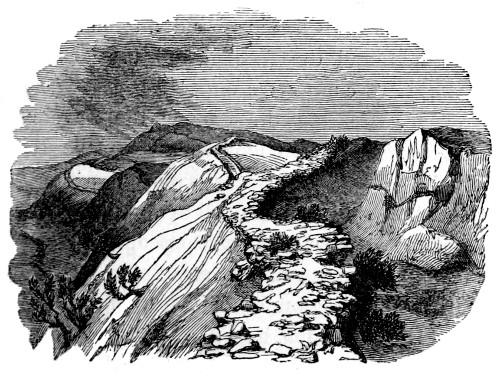
We now enter upon a most interesting part of the line. The mural ridge, divided by frequent breaks into as many isolated crags, is denominated the Nine Nicks of Thirlwall. The view from the edge of the cliff is extensive; stunted trees unite with the craggy character of the rock in giving variety to the foreground. The Wall adheres, with tolerable pertinacity, to the edge of the crags, and hence pursues a course that is by no means direct. The accompanying wood-cut, which exhibits the view looking eastwards, shews the zig-zag path which it adopts. Nearly all our historians agree in stating that the 266most perfect specimens of the Wall now remaining, are on Walltown crags. Certain it is that all who have examined the other parts of the Wall with care, will visit this with peculiar pleasure; but such are the varied features which each section of the Barrier presents, and the consequent interest which each excites, that it is difficult to determine which part, on the whole, is most worthy of attention.
WALLTOWN-CRAGS.
For a considerable distance along the crags, the Wall is in excellent preservation, presenting, on the north side, in several places, ten courses of facing-stones, and in one, twelve. In the highest part it is eight feet nine inches high, and nine feet thick. The military way may in many places be seen, avoiding very dexterously the more abrupt declivities of its rocky path.
At length the cliffs, which extend in a nearly unbroken series from Sewingshields to Carvoran, sink into a plain, and the fertility and the beauty of a well-cultivated country re-appear.
However pleasing the change, the traveller will not fail occasionally to look back upon the road he has trod, and view with secret satisfaction those bold and airy heights which so well symbolize the austere and undaunted spirit of that great people whose works he is contemplating; and when in after years, and it may be in some region far distant, the image of them rises in his imagination, he will be ready to exclaim—
I feel the gales that from ye blow
A momentary bliss bestow.
CARVORAN.
267MAGNA, the modern Carvoran, lies to the south both of the Vallum and Wall. The nature of the ground in its neighbourhood seems to have dictated this arrangement. The Wall occupies the edge of a strip of elevated ground, the benefit of which, as a position of strength against an enemy, it was desirable not to lose. Had the station been placed as usual on the line of the Wall, the Vallum, in skirting its southern rampart, would have been brought into a swamp that occupies the valley between the high ground on which the Wall stands, and the somewhat commanding site of the station. Both the lines of the Barrier have therefore been allowed to pursue their parallel course nearly together, and the station has been placed about two hundred and fifty yards within the Wall, on a platform which is sufficiently defended on the south by the declivity that slopes from it to the modern village of Greenhead.
It is not impossible, however, that Magna may have been one of Agricola’s forts, the valley, through which the river Tipalt flows, requiring the adoption of this method of resisting the aggressions of the Caledonians.
The station has enclosed an area of four acres and a half. Having, a few years ago, been brought under tillage, it is with difficulty that even its outline can now be traced; some fragments of the north rampart, however, remain, and the north fosse is distinct.[121]
MAGNA.
268In the front of the farm-house which was erected in the year—long to be remembered in these parts—1745, is built up a Roman altar, apparently without an inscription. In the garden, and behind the dwelling, are several other interesting memorials of Roman occupation. Amongst them are broken capitals and fragments of columns, moulded coping-stones, gutter-stones, and troughs, of various shapes and rude construction. Several bases of columns lie scattered about, the prevailing form of which is square, as shewn in Plate XIII., fig. 5; one of them is, however, of circular shape, and is ornamented with a cable-pattern moulding, resembling the Housesteads pedestal, given in Plate XI.[122] There are also preserved here a small altar, in perfect preservation, inscribed, D[E]O BE[L]ATVCADRO, some imperfect altars, several centurial stones, a broken effigy of the bird of Jove, a pair of bronze shears (figured of the full size on Plate XIV., fig. 1), evidently, from their proportions, meant to be handled by fair fingers, fragments of Samian ware and amphoræ, a few beads, and some implements of iron. Amongst the articles disinterred from the stations on the line, there are generally to be found numerous small flat circular implements, of which examples 269are engraved (of the full size) on Plate XI. They vary from half-an-inch to two inches in diameter, and have a circular hole in the centre. For the most part they are composed of sherds of Samian ware, occasionally, of jet, and of amber; at Carvoran are some of rude shape, made of imperfectly burnt clay and shale. Various conjectures have been hazarded respecting their use; the most probable is, that they were employed as tallies, the small beads representing units, the large, tens. In the inn at Glenwhelt are preserved a magnificent pair of stag’s horns, nearly perfect, which were found in the well of the station; each antler is a yard long. In the possession of the Society of Antiquaries, Newcastle-upon-Tyne, are several valuable inscribed stones derived from this station, which have been presented by Colonel Coulson of Blenkinsop Hall.
PLATE XIV.
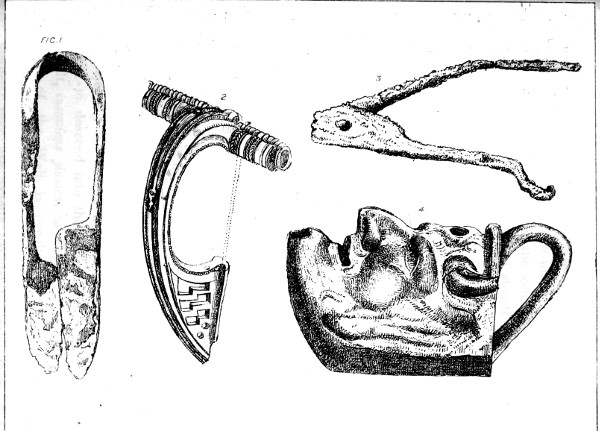
Lamp, Fibula, Shears, and Compasses
Magna, during the days of Roman occupation, must have been a place of considerable importance. Not only did the road which leads directly from Cilurnum, come up to it, but the Maiden-way, from Whitley Castle and the south, ran through it, as is supposed, to Bewcastle and the other stations north of the Wall, as shewn on the Map, Plate I.
Rejoining the lines of the Barrier, we find them about to descend into the valley watered by the Tipalt, insaniens flumen, as Camden calls it. The moat of the Wall is peculiarly well developed, that of the Vallum, though less so, is still distinct; they are exactly parallel to each other. Before the traveller forsakes his present elevation, 270it will be well for him to mark the westward course of the objects of his study, lest he lose their track in the swampy ground fronting Thirlwall Castle. A valley of considerable extent stretches before him; on the north brow of it, at the distance of about three miles, Gilsland Spa is situated; the works of the Barrier stand upon its southern edge. The trough of the north fosse may easily be discerned where it is intersected by the railway.
It has been suggested that one of the objects contemplated by the Romans in the construction of a double line of fortification, was the enclosure of a space of ground which might be cultivated by the garrison, and where their cattle might graze in security. If this had been the case, the Wall would have been drawn along the northern margin of the wide and fruitful valley of Gilsland, and the Vallum along its southern edge.
THIRLWALL CASTLE.
Thirlwall Castle is, as Hutchinson calls it, ‘a dark, melancholy fortress’ of the middle age.[123] It was for many centuries previous to its purchase by the ancestors of the earl of Carlisle, the residence of an ancient Northumbrian family of the name of Thirlwall. Amongst the witnesses examined on the occasion of the famous suit between the families of Scrope and Grosvenor, for the right 271to bear the shield ‘azure, a bend or,’ which was opened at Newcastle-upon-Tyne in 1385, before king Richard II. in person, was John Thirlwall, an esquire of Northumberland. The witness related what he had heard on the subject of the dispute, from his father, who ‘died at the age of 145, and was when he died the oldest esquire in all the North, and had been in arms in his time sixty-nine years.’ Such is the language of the record of these proceedings, preserved in the Tower of London.
This locality may also bring to the reader’s remembrance the lines in Marmion—
The whiles a Northern harper rude
Chaunted a rhyme of deadly feud,
‘How the fierce Thirlwalls, and Ridleys all,
Stout Willimondswick,
And Hardriding Dick,
And Hughie of Hawdon, and Will o’ the Wall,
Have set on Sir Albany Featherstonhaugh,
And taken his life at the Deadman’s-shaw.’—
It is not generally known that this ‘ancient ditty,’ which sir Walter Scott gives at length in a note as a genuine antique, is a modern fabrication, the production of his correspondent Surtees, the historian of Durham. The ballad, however, breathes the very spirit of the fierce borderers, or it would not have deceived so accomplished an antiquary as Scott.
The walls of the castle are nine feet thick, and are faced, both inside and outside, with stones taken from the Roman Wall. It is a singular thing to see a building, formed out of a prior structure, itself 272in ruins, and becoming a prey to yet more modern depredators. The stones remain meanwhile, whether in the primeval structure, or in those of mediæval and recent date, as good as ever. Brand observes—
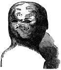
There is built up near the inn at Glenwhelt, a most barbarous, gigantic head of stone, which is most certainly not Roman. It came from Thirlwall Castle, and has no doubt belonged to some of those hideous figures made use of anciently in such castles to frighten the distant enemy.
Brand’s original still graces the vicinity of the inn, and its effigy, this page. Its ugliness is no proof that it is not Roman; but, after all, whose beauty would not be tarnished by exposure such as it has endured?
CENTRAL REGION OF THE BARRIER.
That portion of the line which lies between the Tipalt and the Irthing is probably weaker than any other between Wallsend and Bowness. Not only is the ground flat, but it is destitute of the aid which copious rivers give it, both at its eastern and western extremities. Throughout the whole of this district, both barriers keep close together. Except in the neighbourhood of Rose-hill, no portion of the stone Wall remains in all this tract.
The country between the Tipalt and the Solway is characterized by a number of diluvial hills, not unfrequently resembling barrows. To the south of Brampton, they are so numerous and so nearly uniform in size and shape as to suggest to the playful 273imagination the idea of their being gigantic mole-hills. The occurrence of these in the line of the Barrier must have caused some trouble to the engineer of the Wall. The difficulty, however, was overcome. The first hill of this description that we meet with, occurs immediately westward of the point where the Newcastle and Carlisle railroad crosses the mural line. The Wall unhesitatingly ascends it on the one side, and descends it on the other, though it would scarcely have described a larger arc had it gone round its base.
VALLUM AT WALLEND.
About half-a-mile onward is a small village, called Wallend. The earth-works are, for a short distance, in an admirable state of preservation; nowhere else is the Vallum seen to greater advantage.
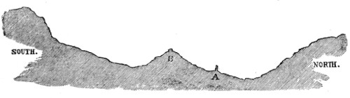
A peculiarity in the relative position of the Wall and Vallum will here force itself upon the attention. The Wall, which, for the larger portion of its course, stands considerably above the Vallum, now takes a lower level, and for nearly the whole space between this point and the Irthing, is completely commanded by the earthen ramparts. The following diagram will give a general idea of the country, and of the mutual relation between the two structures. Had the Wall (A) and Vallum (B) been independent undertakings, 274this arrangement would not have been adopted. The earth-works ascribed to Hadrian having been found inefficient, would have been relentlessly cut in upon by the officers of Severus, who would doubtless have planted the Wall in those positions which were naturally the strongest, irrespective of any prior work. As it is, to give the Vallum the advantage of an eminence in resisting a southern foe, the Wall relinquishes a portion of the acclivity which it might with advantage have taken.
CHAPEL HOUSE.
Chapel-house and Fowl-town, two contiguous farm-houses, are next met with in our course. Chapel-house is probably the site of a mile-castle, it having been constructed out of the materials of a prior building, which boasted walls of great thickness. An inscribed stone, of which the woodcut is a copy, is to be seen lying in an out-house, from the walls of which it has recently been taken. The letters on one end have been worn away. The inscription may be read—
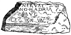
NERVÆ N[EPOTI]
TRA[IANO] HADRIA[NO]
AVG[VSTO]
LEG. XX. VV.
To the grandson of Nerva,
Trajanus Hadrianus
Augustus,
The twentieth legion, valiant and victorious.
This is another testimony which recent research has brought to light, of the part which Hadrian and the twentieth legion bore in the construction, both of the Wall and the Vallum.
275At the village of Gap, the Vallum, which is very distinct, stands considerably above the Wall. The place is said to take its name from the Wall having been broken through here at an early period.
Rose-hill is a hill no longer. The top of the diluvial mount was thrown into the surrounding hollow, in order to afford a site for the railway station, that has assumed the name of the summit which it displaced.
MUMP’S HALL.
In the immediate neighbourhood of Rose-hill is Mump’s-hall, formerly the residence of the Meg Merrilies of sir Walter Scott:—
'Mump’s-hall,' says Hodgson, 'according to tradition, was once a public-house, kept by a notorious person of the name of Meg Teasdale, who drugged to death such of her guests as had money. In Guy Mannering she glares in the horrid character of Meg Merrilies. But certainly all this tradition is deeply coloured with unpardonable slander against the ancient and respectable family of the Teasdales of Mump’s-hall.'
Sir Walter Scott was in early life an occasional resident at Gilsland. The broad, flat stone is pointed out, a little above the Shaws Hotel, on which tradition asserts he was standing when he declared to the subsequent lady Scott the emotions which agitated his bosom. He had therefore the opportunity of becoming acquainted with the district and its traditions.
The small thatched cottage, opposite to the road leading from the railway station, is usually pointed out as the residence of Meg, but it is not the one which was occupied by her. She lived in the larger building beyond, round which the road bends at a right angle. The front of the house is modernized, but the back of it still retains the character of a border fortress. My information upon this and other subjects respecting her, has been derived from an individual residing in the district, whose mother knew Meg well, and visited her upon her death-bed. Although the heroine of Mump’s-hall was cast in a mould 276somewhat suited to the state of the district at that time, she was not the fiend-like woman that she is generally represented. One murder, however, the tradition of the country lays to her charge. A pedlar having called upon Meg’s brother, who kept a school at Long Byers (mid-way between Rose-hill and Greenhead), accidentally presented to him a box filled with guineas instead of his snuff-box. The traveller was requested to convey a note to Mump’s-hall, which he did, but was not seen alive afterwards. Suspicion arising, the house was searched, and the body found concealed among hay in the barn; but the parties who made the discovery durst not reveal it, for fear of injury to themselves and families. About six weeks afterwards the body was found lying upon the moors. My informant added to his narrative—‘probably the laws were not so active in those days as at present, for these things could not escape now.’
When Meg was upon her death-bed, the curiosity of the neighbourhood was excited, and many of her cronies visited her, in hopes of hearing her disburthen her conscience respecting the death of the pedlar. They were, however, disappointed; for whenever she attempted to speak upon the subject, some one of the family, who always took care to be present, placed a hand upon her mouth.
Upper Denton church is hard by. It is evidently a very ancient building, and possibly exhibits some Saxon work. It is one of the smallest churches in England, and is as damp and mouldy as felons’ dungeons used to be. Meg and several of the members of her family lie in the church-yard. Four tombstones, ranged in a row, mark their resting places.
POLTROSS-BURN.
The works of the Barrier are crossed by the railway a little to the west of Rose-hill station. The Wall here exhibits three or four courses of facing-stones. A little beyond this point, the lines, still clearly defined, cross the stream called Poltross-burn, which divides the counties of Northumberland and Cumberland. The gorge in which the stream flows is deep 277and well-wooded. There are no remains of a bridge in the valley, but traces of a mile-castle, by which the defile has been guarded, are distinct upon its western bank. Before reaching the Irthing, at a farm-house called Willowford, the site of another castellum may be discerned. From this point to the water’s edge, the Wall and Vallum have probably gone in close companionship; but this is a matter which cannot now be ascertained. The western bank of the river is lofty and precipitous. Consisting, as it does, chiefly of diluvial soil and gravel, on which the water of the stream below is continually acting, it is not surprising that all traces of the Wall, if it ever ascended the height, have long since disappeared. On the very brink of the precipice above, the remains of the Wall and fosse re-appear. The faithful followers of the Wall, who have closely pursued its track from the eastern sea, will not be willing to desert their companion, even for a brief space, at this point. The cliff, however, will test their constancy. Hutton had his troubles; he says, somewhat magniloquently—
PASSAGE OF THE IRTHING.
I had this river to cross, and this mountain to ascend, but I did not know how to perform either. I effected a passage over the river by the assistance of stones as large as myself, sometimes in and sometimes out; but, with difficulty, reached the summit of the precipice by a zig-zag line, through the brambles, with a few scratches.
The latest historian of the Wall attempted to ascend the bank in a right line; he has given us the result of his experience, as a warning to others.
278None of the party completely succeeded in ascending the precipitous bank by the course of the Wall. The attempt is very dangerous, and, as success accomplishes nothing, should never be tried by those whose life and existence are in any way useful.
On the top of the cliff is a mile-castle. To the north, two conical summits appear, which strongly resemble barrows. We now approach Birdoswald, the twelfth station on the line.
AMBOGLANNA.
AMBOGLANNA, the Birdoswald of the present day, is an interesting station.
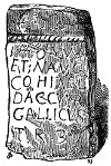
Numerous inscriptions have been found within its walls, mentioning the first cohort of the Dacians, surnamed the Ælian, which, according to the Notitia, was quartered at Amboglanna. One of them, in the possession of Robert Bell, esq., of the Nook, Irthington, is here figured.
I[OVI] O[PTIMO] M[AXIMO]
ET N[VMINIBVS] AVG[VSTI]
COH[ORS] PRIMA AEL[IA]
DAC[ORVM] CVI PR[ÆEST]
GALLICVS
TR[I]B[VNVS]
To Jupiter, the best and greatest,
And the deities of Augustus,
The first cohort (the Ælian)
Of the Dacians, commanded by
Gallicus,
The Tribune.
The name Amboglanna seems to signify, the circling glen. The former part of the word, meaning about, is met with in most of the western languages; as the Welsh am, the Irish and Gaelic umain, the Saxon ymb or embe, the Greek αμφι, and the Latin (in compound words) amb. Glanna is obviously 279synonymous with the modern glen, a term of very frequent use in the land of the Gäel.
Here the name has been most appropriately bestowed. The camp stands upon the precipitous edge of a tongue of land, which, on every side except the west, is severed from the adjoining ground by deep scars. Hodgson describes the spot with great accuracy—
The Irthing, in front of the station, makes two grand and sweeping turns, under red scars, which have rich flat grounds before them, deeply fringed along the margin of the river with a border of alder, heckberry (Prunus Padus, or bird-cherry,) and other upland trees. When the banks are not steep, they are deeply wooded: and diluvial hills, rounded into vast and beautiful varieties of form, present to the eye rich sylvan and cultivated scenes, while their component parts, as the river passes their sides, expose to the geologist rounded specimens of the different kinds of rocks to be found in the plains of Cumberland, and the high mountains that lie on each side of the Firth of the Solway.
BIRDOSWALD.
The modern name presents greater difficulties than the ancient one. Had king Oswald been a denizen of these parts, which he was not, we might have supposed that Birdoswald was a burgh of his. The name is one of old standing, but the etymology of it can only be a subject of conjecture.[124]
The station contains an area of between five and six acres. The walls are in an unusually good state of preservation; the southern rampart shewing eight courses of facing-stones. Camden’s statement 280is still true to the letter;—‘it has been surrounded with a stately wall of free-stone, about five feet thick, as may be fairly measured at this day.’ The moat which surrounded the wall may also be satisfactorily traced.
Although the Wall adapts itself to the north rampart of the fort, the station is entirely independent of the Wall (see the wood-cut p. 84), and must have been built before it. Probably the first step taken in the construction of the Barrier, in every case, was the erection of the stationary camps.
The Vallum cannot now be traced in the immediate vicinity of the station; but Gordon tells us, that it came close up to the southern rampart.
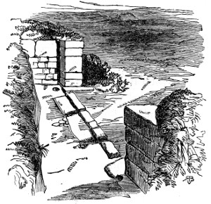
The southern gateway may be discerned, though it is encumbered with rubbish; the eastern and western have recently been divested of much of the matter that has for ages obscured them. The wood-cut, representing the western portal, as seen from the inside, exhibits the pivot-holes of the gates, and the ruts worn by the chariots or wagons of the Romans. The ruts are nearly four feet two inches apart, 281the precise gauge of the chariot marks in the east gateway at Housesteads. The more perfect of the pivot-holes exhibits a sort of spiral grooving, which seems to have been formed with a view of rendering the gate self-closing. The aperture in the sill of the doorway, near the lower jamb, has been made designedly, as a similar vacuity occurs in the eastern portal; perhaps the object of it has been to allow of the passage of the surface water from the station.
The whole area of the camp is marked with the lines of streets and the ruins of buildings. The present farm-house occupies, according to Horsley, the site of the pretorium. On the east side of the southern gateway are the remains of a kiln for drying corn; the stones are reddened by fire. Near the eastern gateway a building, furnished with a hypocaust, has been partially excavated. From its ruins a sculptured figure, draped, and in a sitting posture, has recently been taken. The head and other highly relieved parts were found to have been broken off: it remains on the ground.
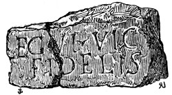
A large altar with an inscription, which is in a great measure illegible, lies within the walls of the camp. A stone broken in two pieces, and which is preserved on the spot, bears testimony to the presence of the sixth legion here; it may be read, LEGIO SEXTA VICTRIX FIDELIS—The Sixth legion the Victorious and Faithful.
AMBOGLANNA.
282The boldness of the lettering, and the depth and clearness of the cutting, give reason to suppose that the inscription is of early date. Besides these, several centurial stones, mill-stones, and coping-stones, as well as portions of tile, and fragments of pottery, are preserved in the farm-house, and yield to the visitor indubitable proofs of Roman occupation. In draining the field to the west of the station, many small altars, without inscriptions, have been found, which were remorselessly broken, and used with other materials for filling the drains. Strange, that altars before which Romans of ‘fierce countenance’ have bowed, should be put to such a use!
Imperious Cæsar, dead, and turned to clay,
Might stop a hole to keep the wind away:
O, that the earth which kept the world in awe,
Should patch a wall to expel the winter’s flaw!
On the east of the station are extensive and well-defined marks of suburban buildings.
The accompanying lithograph is taken from the western side of the station. It well represents the chilly and somewhat forbidding aspect of this now nearly deserted place.
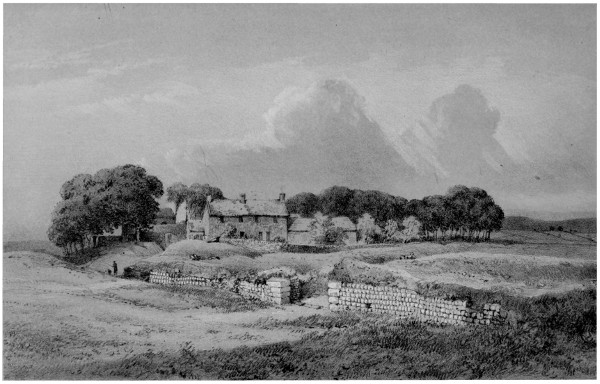
H. Burdon Richardson, Delt.John Storey, Lith. BIRDOSWALD, WESTERN RAMPART. Printed by W. Monkhouse, York.
Westward of Birdoswald, the Wall is in an unusually good state of preservation. Taking into account, not only the height, but the length of the fragment, and the completeness of the facing-stones on both sides, it may be pronounced the finest specimen of the great structure that now remains. Some portions of it, however, are beginning to exhibit evident signs of decrepitude and decay.
283

Within a short mile of the station, the remains of a castellum appear. Here the Vallum exhibits the unusual feature of a second ditch, as is represented in the subjoined section.[125] Hodgson says—
Through a bog, about a mile west of Amboglanna, the Vallum has had two ditches, probably intended for draining the military road that ran between them. They are still very distinct.
A careful examination of the spot induces me to think, that the additional fortification was intended to give increased security to a defile, which, running from the vicinity of the Wall to the bed of the Irthing below, renders the works in this part more than usually liable to attack from the south.
THE WORKS AT WALLBOURS.
At the western extremity of this extra ditch, the Wall and Vallum come into close proximity; the space between them was, with the exception of room for the military way, occupied by the foundations of a castellum. The place bears the name of Wallbours.
The Barrier next crosses a small hill called the Pike. The Vallum is a little below the summit of the eminence, on its southern side; if this fortification had been formed irrespective of the Wall, it would 284doubtless have been drawn along the top of the height. The same remark applies to Hare-hill.
The view from the Pike, of the flat and fertile vale below is truly magnificent.
THE WALL AT HARE-HILL.
Soon after passing Banks-burn, we arrive at Hare-hill, where a portion of the Wall stands nine feet ten inches in height. This is the highest piece of the Wall that is anywhere to be met with; but, owing to the smallness of the fragment, and to its being entirely deprived of facing-stones, it is less imposing than it would otherwise be. Hutton’s enthusiasm, however, never fails him; his remark at Hare-hill is—
I viewed this relick with admiration: I saw no part higher.
At this point of our progress, the antiquary may be disposed to turn aside for a little, to view two relics of the mediæval period of great interest—Lanercost Priory and Naworth Castle. The priory is a beautiful specimen of the early English style, and bears architectural evidence of having been built somewhere between the years 1155 and 1160. Besides the church, partially in ruins and partially in repair, the refectory and some portions of the monastic buildings remain. The whole structure has been formed of stones taken from the Roman Wall. In addition to some altars preserved in the crypt of the church, several centurial and carved stones are to be seen in the walls of the adjacent buildings.
NAWORTH CASTLE.
Naworth Castle, though still an interesting building, is destitute of some of the attractions which it once 285possessed. The Roman altars and other primeval monuments collected by lord William Howard, have long been dispersed, and a fire in 1844, almost entirely destroyed the baronial residence of that renowned border-chief, which, until that event, remained nearly in the state in which it was in his own day. The dungeons, however, in which the daring moss-troopers were immured, remain, and two magnificent oak trees near the grand entrance still extend those brawny arms on which, according to tradition, lord William suspended the victims of his lawless power. The load of twenty gasping wretches would not materially weigh down the larger boughs of these fine trees. That the government of lord William—the Belted Will of Border tales—was of a vigorous character, there cannot be a doubt; but that he used his power capriciously, cruelly, or tyrannically, there is no evidence. Lord William seems to have sent the most desperate of his prisoners to Newcastle-upon-Tyne or Carlisle. They would probably have as good a chance for life at Belted Will’s tribunal as at the assizes of either of these towns, if we may judge of the state of feeling towards them from North’s Life of Lord-keeper Guildford. His lordship, then sir Francis North, came to Newcastle, on the northern circuit, in 1676. His biographer says—
The country is yet very sharp upon thieves; and a violent suspicion, there, is next to conviction. When his lordship held the assizes at Newcastle, there was one Mungo Noble, supposed to be a great thief, brought to trial before his lordship, upon four several indictments; and his lordship was so 286much a south-country judge as not to think any of them well proved. One was for stealing a horse of a person unknown, and the evidence amounted to no more than that a horse was seen feeding upon the heath near his shiel, and none could tell who was the owner of it. In short the man escaped, much to the regret of divers gentlemen, who thought he deserved to be hanged, and that was enough. While the judge at the trial discoursed of the evidence and its defects, a Scotch gentleman upon the bench, who was a border commissioner, made a long neck towards the judge and said—'My laird, send him to huzz, and ye’s ne'er see him mair.'
On rejoining the Barrier, we find, that though the line of the Wall, in its course to the Eden, may yet be distinctly discerned, in very few instances any portion of the masonry remains.
MONEY-HOLES.
The site of a mile-castle nearly opposite Lanercost Priory, is termed Money-holes, in consequence of the efforts made to discover some treasure supposed to be concealed in it. At Crag-hill the north ditch is very bold. At Hayton-gate, a drove road, probably an ancient pass, crosses the line of the Wall from north to south. At Randilands the north fosse is still well developed. After crossing the rivulet, called Burtholme-beck, a piece of the Wall is seen, which stands about seven feet high; its facing-stones are gone, but the rough pebbly mortar possesses its original tenacity. As is often the case, the ruin is tufted with hazel bushes and stunted specimens of the alder and oak. The Vallum is about seventy yards to the south of the Wall.
Approaching Low-wall,[126] something like an out-work 287appears on the north side of the Barrier. Has there been a double line of wall here? After crossing a road, denominated Friar-wain-gate, which leads from Bewcastle to Lanercost, we reach another house called Wall; Roman masons might claim many of the stones as theirs. At How-gill is a cottage, where probably a mile-castle stood to defend the ‘beck,’ In the modern structure may be observed stones broached in the Roman fashion, and others variously tooled by Roman hands.
The farm-house of Dove-cote is on the eastern bank of the King-water. The fosse and the foundation of the Murus are seen crossing the hill on the northern side of the summit: the Vallum, which is indistinctly marked, probably took a corresponding position on the southern side.
WALTON.
The village of Walton, by its very name, bears testimony to its relationship with the great Barrier-line. Many of the stones of the Wall may be detected in its cottages. One of its dwellings furnishes a good specimen of the mode of cottage-building formerly prevalent in the North. The rafters of the house, which consist of large and rudely-shaped pieces of timber, instead of resting upon the walls, come down to the ground; they are tied together near the top by a transverse beam, and the mud walls, as well as the thatched roof, partially depend upon them for support. Horsley says, 'at Wal-town there seems to have been some fortification or encampment. One side of the square is yet very visible, and the ramparts pretty large, about eighty 288yards long. It is high ground and dry. Perhaps it has been a summer encampment or exploratory post for the garrison at Cambeck.'
At Sandysike farm-house the foundation of the Wall as well as abundant traces of mural vicinage are to be seen. The barn consists of Roman stones marked with the diamond-broaching. Several sculptured stones are built up in the garden-wall; amongst them is one which displays the thunderbolt of Jove; the wall-fruit peacefully rests upon it. Another, exhibiting the wheel of Nemesis, the emblem of swift justice, and which no doubt once formed part of an altar to Jupiter, is built into a pig-sty. A mill-stone of peculiar shape, and closely resembling one at Naworth Castle, is preserved on the grounds; it is probably Roman.
PETRIANA.
PETRIANA, the Cambeck-fort of Horsley, and the Castle-steads of the locality, is to the south of the Vallum and Wall. A deep scar separates it from the lines of the Barrier. The site of the station may be recognised, but it is long since its ramparts were overthrown, and the ruined buildings of the interior entirely obliterated.
Its rich soil and sunny exposure recommended it to the father of the present proprietor of Walton-house as a fitting site for a garden, and such it is at the present day. It has yielded many altars and|CAMBECK-FORT.| sculptured stones, some of which are still preserved upon the spot, and from time to time the spade still reveals to the numismatist, treasures, over the loss of 289which, Romans in ancient days may have mourned, though not in a degree proportioned to their present value. Wood-cuts of three of the coins which have been found at Castlesteads are here introduced, as they commemorate the family of a man whose name is intimately connected with the Wall. They are in the cabinet of Robert Bell, esq., of Irthington.
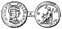
Julia, the second wife of Severus, and the mother of Caracalla and Geta. Severus, who was a believer in astrology, on the death of his first wife, looked out for another whose nativity was favourable to the ambitious views which he at that time entertained. He heard of a woman in Syria whose destiny it was to marry a king, and accordingly solicited and obtained in marriage Julia Domna.
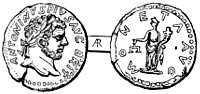
Bassianus, commonly called Caracalla. He was created Cæsar by his father, A.D. 196, when he took the names of Marcus Aurelius Antoninus. In A.D. 198, he was invested with the dignity of Augustus. Amongst his other titles, he bore the name of Britannicus, as is shewn on the coin. The engraver of the die from which this coin was struck, has probably given a correct likeness of his subject; at least, he has represented an individual who appears capable of attempting an aged father’s life, and of imbruing his hands in the blood of a brother. Vengeance at length overtook him.
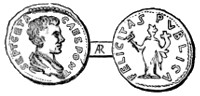
Geta, who, together with his brother Caracalla, accompanied his father to Britain. He was murdered by Caracalla A.D. 212.
The finest of the altars, standing in the garden of Walton-house, is here engraved. The thunderbolt 290of Jupiter adorns one side of it, the wheel of Nemesis the other. The inscription has been read by Mr. Thomas Hodgson, of Newcastle-upon-Tyne, in the following way, after a careful and learned examination of it, and kindred inscriptions.
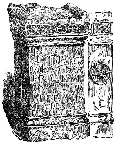
I[OVI] O[PTIMO] M[AXIMO]
COH[ORS] SECVNDA TVNGR[ORVM]
M[ILLIARIA] EQ[ITATA] C[IVIVM] L[ATINORVM] CVI
PRAEEST ALB[VS]
SEVERVS PR-
AEF[ECTVS] TVNG[RORVM] IN-
STA[NTE] VIC[TORE] SEVRO
PRINCIPI
291To Jupiter, the best and greatest,
The second cohort of the Tungrians,
A milliary regiment, having a proportionate supply of horse, and consisting of citizens of Latium,
Commanded by Albus
Severus, pre-
fect of the Tungrians, erects this;
The work being superintended by Victor Sevrus (or Severus), the princeps.[127]
PETRIANA.
The Notitia places the ‘Ala Petriana,’ under a prefect, at Petriana. Although two inscriptions belonging to this place mention the second cohort of the Tungri, none have been found here which name the Ala Petriana. It is possible that this cohort may have been a part of the Ala Petriana, but until this point be settled, or some further light thrown upon the subject, the occurrence of Cambeck-fort|CAMBECK-FORT.| next in order to Amboglanna, must be regarded as the 292best evidence of its being the Petriana of the Notitia.
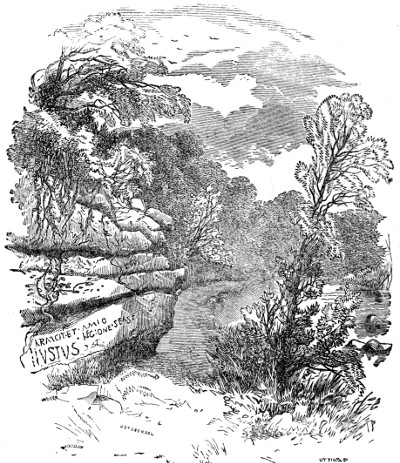
WRITTEN-ROCK OF GELT.
Before crossing the Cambeck-water it may be well to remind the reader, that the river Gelt, on whose rocky banks the Roman quarrymen have left lettered memorials of their toil, is about four miles to the south of this place. With the view of clearly displaying the inscription, which has frequently been inaccurately engraved, the lithograph opposite to page 81, has been drawn to a scale which precludes the possibility of shewing the height of the cliff. The 293adjoining wood-cut partly supplies this deficiency; it exhibits another inscription, not of a very intelligible.|PIGEON-CRAG.| character, on the Pigeon-crag, which is a little higher up the water, and shews the general character of the scenery on this beautiful stream.
The distance of these quarries on the Gelt, from the line of the Barrier, renders it very questionable whether large supplies were derived from them for the Wall. Hodgson remarks—
The quarry at Helbeck-scar (the Written-rock) might serve for the largest stones for part of the Murus, and the stations at Brampton-old-church, and Walton-castlesteads; for the general purpose of the Murus, stone, however, could be got in places much nearer than Helbeck-scar.
At the quarries of High and Low Breaks, about a mile and a half north of the Wall, there are marks of extensive ancient workings; the quarries are still in use and yield stone of good quality.
The Written-rock will not be easily found by a stranger, but directions and assistance may generally be obtained from the workmen employed upon a modern quarry, which is not far from the spot.
HEADSWOOD.
We now rejoin the Barrier. The passage of the Cambeck-water seems to have been guarded with some care. On the eastern margin of the stream, to the north of the Wall, is an earth-work raised a little above the general level of the surface, which here is somewhat depressed. Stones, which do not appear in the contiguous parts, lie scattered about the place. These circumstances seem to favour the idea of there having been some additional fortification 294in this part. The western bank of the stream consists of a bold breastwork of red-sandstone, rising about fifty feet above the level of the water. The fosse of the Wall has been deeply cut into this rock; it still remains in a state of great perfection. The old drove-road between Newcastle and Carlisle, which, for some distance west of this, runs upon the site of the Wall, or close by it, here avails itself of the fosse as a means of climbing the bank. The ditch of the Vallum is also discernible. The farm-house of Beck is partially constructed of Roman stones, and on the east side of the rivulet of Beck a few stones of the Wall are in their original situation. Headswood, as its name implies, occupies a commanding position. The ditch of the Vallum is at this place peculiarly bold, and is about thirty-five yards distant from the Wall. The fosse of the Wall bends round an object which has the appearance of being an additional fortification outside the Wall. At the west end of Newtown-of-Irthington are the remains of a large mile-castle; the stones still lie in confusion upon the site. The stone represented in the margin was found at this place. We next come to White-flat, where the rubble of the foundation of the Wall is very discernible and the ditch very deep. Hurtleton (the town of strife) is next reached; both lines of fosse are distinct and in close contiguity.
In the corner of a field, called Chapel-field, there are 295evident signs of a mile-castle; the plough, however, has been drawn over the site. The two works, which between White-flat and this point have approached each other very closely, now quickly diverge, the Wall bending to the north.
IRTHINGTON.
The village of Irthington is a little to the south of the Barrier. Here formerly stood one of the strongholds of the powerful Norman family of De Vallibus; the building is now entirely removed, its site being occupied by the Nook, the residence of Robert Bell, esq. The foundations of some of its walls have recently been exposed. The keep probably occupied a lofty earthen mound which is now crowned with thriving trees. The parish church has recently been renewed with much skill and taste. The old fabric was entirely built of Roman wall-stones. In the course of its restoration, a striking proof of the disturbed state of the border district in the middle ages was disclosed; a number of skeletons, confusedly thrown together, being found buried within its area. The church, originally a Transition-Norman building, had evidently at some period after its erection, been contracted in its dimensions by the rejection of the side aisles. The outer walls consisted of the original columns of the aisles, filled up very roughly with common rubble. The columns bore decided marks of fire. The neighbouring parish church of Kirklinton, which has also been recently rebuilt, exhibited similar appearances. On taking down the old tower, which was a fortified stronghold, the bony remnants of upwards of sixty bodies were found in a space of not more than five 296yards square; others were found in confused masses in other parts. |BORDER STRIFE.| The probable explanation of these circumstances is this:—After the battle of Bannockburn, the Scottish forces, flushed with success, entered England, and the inhabitants, unable to withstand them, fled to the churches for protection. But neither the strength of the buildings nor their supposed sanctity could yield them effectual succour; the miserable people were slain, and their bodies left among the smouldering ruins. Those of their countrymen who escaped, buried them in a hasty manner upon the spot. When the desolated district had recovered energy enough to repair the churches, its utmost efforts were barely sufficient to enclose those parts which had, by their solidity, withstood the fire; and the reduced population required nothing more.
The coins of Edw.I. and II. are comparatively abundant in this district, the armies of that monarch and his immediate successors, frequently taking the western route, in their marches to and from Scotland.
Rejoining the Wall, we meet, when within a quarter of a mile of Old-wall, with the site of a mile-castle. The ruins of the building slightly raise it above the general level, and prevent the plough biting into it. The road formerly deviated from its track to go round it. An altar, an urn, and several coins of Edward I., have been found in it. In the buildings at Old-wall, many Roman stones will be noticed, and the earth-works of both lines of the Barrier may be traced. The Wall is entirely uprooted; 297upwards of six hundred cart-loads of stones, within the recollection of the inhabitants, have been taken from it in this immediate vicinity.
Between this point and Stanwix, the works may be traced with tolerable satisfaction, an ancient drove-road running upon the site of the Wall for the greater part of the way.
BLEATARN.
At Bleatarn (blue tarn or lake), on the south side of the Wall, is a mound of earth resembling an elongated barrow; between this earth-work and the Wall, is a marshy hollow, which is said to have formerly been the bed of a lake or tarn. The Vallum takes a sweep to avoid this morass, and at its greatest distance is removed from the Wall about two hundred and twenty yards.
About half-a-mile south from Bleatarn, is the site of a Roman camp, which Horsley conceived to be one of the stations per lineam Valli; it is now called Watch-cross. If it be a station of this class, and if the order in which the stations are arranged in the Notitia exactly corresponds with their consecutive positions in reality, the name of it was Aballaba, which was garrisoned by a numerus or troop of Moors, under a prefect. There is, however, reason to doubt whether this was a stationary camp at all, as will presently appear.
As already remarked, no inscribed stones have been found to identify any of the stations west of Amboglanna with the list given in the Notitia. Even though this difficulty respecting Watch-cross had not occurred, to go on appropriating the names of 298the Notitia, station after station, guided solely by the slender thread of the order of their succession, would be a hazardous undertaking, and is rendered still more so by the uncertainty existing as to those which are, and which are not, stationes per lineam Valli. In our journey from this point westward, the stations will, therefore, be designated by their modern names; when the Latin names are added, it is to be understood that they are conjectural.
WATCH-CROSS.
WATCH-CROSS.—Horsley gives the following account of this station:—
A little detached from the wall, to the south, is a Roman fort, of about four chains and an half square, called Watch-cross; and as I was assured by the country people, and have had it since further confirmed, a military way has gone near it, or between it and the military way belonging to the Wall; for they often plough up paving stones here, and think part of the highway to Brampton to be upon it. This is the least station on the line of the Wall, and is as usual, plundered of its stones, as that at Burgh and Drumburgh. However, the ramparts and ditches are very fair and visible.
The common on which it stood having been enclosed about seventy years ago, and brought into cultivation, all traces of the camp have been obliterated. On a careful examination of its site, I failed to discover any fragments of Roman pottery, or other marks of Roman occupation. In those parts of Cumberland where the soil is not naturally stony, the site of a mile-castle or station, which has been brought into cultivation, may often be distinguished by the occurrence in that particular spot of numerous fragments of freestone. No such appearance here 299presents itself. The person who farms the ground says it is of better quality than the surrounding land; still, it does not seem to possess the peculiar fertility of a spot that has at any period for a length of time been the resort of a crowded population. Hutchinson describes ‘the whole ground-plot’ as being covered, in his day, ‘with a low growth of heath;’ the sites of all the other cities of the Wall are too replete with animal remains to yield, even unaided by cultivation, so coarse a product. I am therefore strongly disposed to think, with Hodgson, that it was a mere summer encampment. The spot has been well chosen; for, though not greatly elevated, it has an extensive prospect. Horsley himself had some doubts of the propriety of admitting it into the rank of a stationary camp, ‘by reason of its being so small, and having no remains of stone walls.’ The distance, however, between Cambeck-fort and Stanwix, which is rather greater than that between any other two stations, induced him to give it this position.
From Bleatarn the antiquary will, with some care, be able to trace the Barrier by Wall-head, Walby, and Wall-foot, to Tarraby. From this village to Stanwix, a rural road runs upon the foundations of the Wall; the ditch on its north side, which within living memory was very boldly marked, although partially filled up is yet distinctly traceable.
STANWIX.
STANWIX.—The church and church-yard of Stanwix occupy the site of the station which guarded the northern bank of the Eden. Recent explorations have displayed distinct remains of ancient 300edifices. In pulling down the old church, to make way for the present structure, a very fine figure of Victory, somewhat mutilated, was disclosed, which is now in the museum at Newcastle-upon-Tyne. The name of the place indicates, that whilst the dwellings in the vicinity were made of clay, as many of them are yet, by reason of the plunder of the Roman station, it could boast of being a town of stones. The situation is one of great beauty. To the east, at a considerable distance, the Nine-nicks of Thirlwall rear their rugged peaks; and to the south and south-west, appear the beautiful grounds of Rickerby-house, the river Eden permeating a rich and well-cultivated country, the ancient city of Carlisle crowned with its venerable cathedral, and the long vista of country terminating in the Cumbrian mountains.
Between the station and the north bank of the river Eden, the fosse of the Wall is distinctly marked, and a hollowed line, formed by the excavation of the foundation of the Wall itself, shews its track to the water’s edge, near to the Hyssop-holme-well. We are told by Camden—
That the Wall passed the river over against the castle—where in the very channel, the remains of it, namely, the great stones, appear to this day.
That the Wall, on the other side of the river, clambered up that part of the castle-bank which projects most boldly forward, is rendered probable by the appearance of masonry, resembling its foundations, beneath the grassy surface. At this point, however, we lose all trace of the great structure until we 301get beyond the boundaries of the famous Border city of the West.
CARLISLE.
All antiquaries agree that Carlisle is the Luguvallium of the Romans. It is not improbable that it was one of Agricola’s forts. It is not named in the list of the stations per lineam Valli given in the Notitia. The Notitia mentions only the forts having separate garrisons, and it is probable that after the erection of the camp at Stanwix, Luguvallium became subordinate to that camp, and had no distinct garrison, which will account for its omission.
Whitaker says Luguvallium signifies, in the ancient Celtic, the fort upon the Waters.
Extensive remains of the ancient city lie beneath the modern Carlisle; seldom is the ground penetrated to any considerable depth without disclosing ancient masonry, Samian ware, and Roman coins.
Carlisle contains two interesting structures of the mediæval period—the castle and the cathedral. The keep of the castle is a good specimen of the Norman donjon, though some parts of it have been modernized. On the walls and door of one of its chambers, used as a prison in the ‘Fifteen’ and the ‘Forty-five,’ are to be seen the coats of arms, the devices, and marks of the ‘sorrowful sighings,’ of the unhappy rebels, who beguiled their wretched hours in carving them. The cathedral exhibits some interesting specimens of the Norman as well as later styles. Its east window, which is of the decorated period, is the finest in the kingdom, with the exception, perhaps, of the west window at York.
302About a quarter of a mile beyond the canal basin, and nearly midway between the canal and the river, the track of the Wall may again be discerned. Owing to the difficulty of entirely uprooting it, its foundations have been suffered to remain; they form a cart-road which is used for farm purposes. A little farther on, the plough has won the day, and a uniform green sward or luxuriant harvest baffles our research.
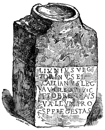
KIRK-ANDREWS.
A turf-covered mound on the east side of the church of Kirk-andrews, is occasioned by a portion of the ruins of the Wall. In the village is preserved the altar of which the wood-cut gives a representation. It was found at Kirk-steads, about a mile south of the Wall, and bears marks of having been 303cut down to suit the purpose of some comparatively modern builder. The focus of the altar is unusually large; the boldness of the lettering indicates an early date. It may be read—
L[VCIVS] IVNIVS VIC-
TORINVS ET (?)
C[AIVS] AELIANVS LEG[ATI]
AUG[VSTALES] LEG[IONIS] VI VIC[TRICIS]
P[IÆ] F[IDELIS] OB RES TRANS
VALLVM PRO-
SPERE GESTAS.
Lucius Junius Vic-
torinus, and
Caius Ælianus, Augustal legates
Of the sixth legion, victorious,
Pious, and faithful, on account of achievements beyond
The Wall pros-
perously performed.
This is a vivid memorial of deeds of common occurrence during the period of Roman occupation. The original possessors of the isthmus, driven from their homes, and forced to seek an asylum in the hills to the north of the Wall, would be accounted the lawful prey of the aggressor.
The gates of mercy shall be all shut up;
And the fleshed soldier,—rough and hard of heart,—
In liberty of bloody hand, shall range
With conscience wide as hell; mowing like grass
Your fresh fair virgins and your flowering infants.
Whilst the Roman warrior gloated over his success, and feasted, and thanked his gods, and recorded his exploits on the votive stone, the routed remnants 304of the Caledonian bands would mourn over their slaughtered comrades and desolated home-steads.
The great scarcity of stone in the western part of Cumberland has rendered the Wall a valuable quarry to the inhabitants from time immemorial. In our future progress we shall see little of it, except in the buildings contiguous to its site. The heart of the antiquary will, however, occasionally be gladdened by the recognition of the lines of the earth-works—their slightly elevated mounds appearing to his eager gaze scarcely less beautiful than the moulded forms produced by the genius of the sculptor, in districts more rich than this, in the remains of antiquity.
The Vallum appears to have gone nearly due west, along the valley, from Kirk-andrews to Burgh; the Wall proceeds, after its usual manner, from eminence to eminence.
BURGH-UPON-SANDS.
BURGH-UPON-SANDS is the next station. In Horsley’s day the remains of its ramparts were to be seen at a place called the Old-castle, a little to the east of the church. He says—
On the west side these remains are most distinct, being about six chains in length. And Severus’s Wall seems to have formed the north rampart of the station. I was assured by the person to whom the field belonged, that stones were often ploughed up in it, and lime with the stones. Urns have also frequently been found here. I saw, besides an imperfect inscription, two Roman altars lying at a door in the town, but neither sculptures nor inscriptions are now visible upon them. ...... If besides all this, we consider the distance from the last station at Stanwix, I think it can admit of no doubt 305but there must have been a station here, though most of its ramparts are now levelled, the field having been in tillage many years. I shall only further add, that it was very proper to have a station at each end of the marsh, which, if the water flowed as high as some believe, would make a kind of bay.
At present, little meets the eye of the inquirer, to inform him of the spot where the station stood, but when the surface of the ground is broken, the traces of a Roman city are still sufficiently distinct. The church-yard is filled with fragments of red sandstone blocks. At the depth of two feet, it contains several distinct lines of foundations. Entire ‘lachrymatory’ vessels and fragments of unglazed jars and urns have repeatedly been dug up. A small bronze figure was recently found. When the canal was cut, blocks of stone, blackened by smoke, were dug out of the soil to the south-east of the church.
A few inscribed stones have been found since Horsley’s day, but none of them name the cohort which was stationed in the camp. Hence we have no means of knowing whether Watch-cross has been rightly thrown out of the list of ‘stations along the line,’ and whether Burgh is, as Horsley states it to be, the Axelodunum of the Notitia, or Congavata, according to the opinion of Hodgson.
In the absence of more decided remains of the camp or Wall, an examination of the church of this long straggling town will reward the attention of the antiquary. It is a good specimen of the fortified Border churches. It has served the threefold purpose of a church, a fortress, and a prison.
306In case of an inroad from the Scottish coast, the cattle appear to have been shut up in the body of the church, and the inhabitants to have had recourse to the large embattled tower at its western end. The only entrance to this tower is from the inside of the church, and it is secured by a ponderous iron door, fastening with two large bolts. The walls of the tower are seven feet thick. Its lowest apartment is a vaulted chamber, lighted by three arrow-slits. At the south angle is a spiral stone staircase, leading to two upper chambers.