Volume 1 — CHAPTER II. GEOGRAPHICAL DESCRIPTION OF THE EASTERN PROVINCES. (continued 2)
Reading edition
Lin-tsing chau, on the Yu ho, at its junction with the Canal, lies in the midst of a beautiful country, full of gardens and cultivated grounds, interspersed with buildings. This place is the dépôt for produce brought on the Canal, and a rendezvous for large fleets of boats and barges. Near it is a pagoda in good repair, about 150 feet high, the basement of which is built of granite, and the other stories of glazed bricks.
The towns and villages of Shantung have been much visited during the past few years, and their inhabitants have become better acquainted with foreigners, with whom increased intercourse has developed its good and bad results. The productions of this fertile province comprise every kind of grain and vegetable found in Northern China, and its trade by sea and along the Canal opens many outlets for enterprising capital. Among its mineral productions are gold, copper, asbestos, galena, antimony, silver, sulphur, fine agates, and saltpetre; the first occurs in the beds of streams. All these yield in real importance, however, to the coal and iron, which are abundant, and have been worked for ages. Its manufactures supply the common clothing and utensils of its people; silk fabrics, straw braid woven from a kind of wheat, glass, cheap earthenware, and rugs of every pattern.
Mr. Stevens, an American missionary who visited Wei-hai wei and Chifu in 1837, gives a description of the people, which is still applicable to most parts of the province: “These poor people know nothing, from youth to old age, but the same monotonous round of toil for a subsistence, and never see, never hear anything of the world around them. Improvements in the useful arts and sciences, and an increase of the conveniences of life, are never known among them. In the place where their fathers lived and died, do they live, and toil, and die, to be succeeded by another generation in the same manner. Few of the comforts of life can be found among them; their houses consisted in general of granite and thatched roofs, but neither table, chair, nor floor, nor any article of furniture could be seen in the houses of the poorest. Every man had his pipe, and tea was in most dwellings. They were industriously engaged, some in ploughing, others in reaping, some carrying out manure, and others bringing home produce; numbers were collected on the thrashing-floors, winnowing, sifting and packing wheat, rice, millet, peas, and in drying maize, all with the greatest diligence. Here, too, were their teams for ploughing, yoked together in all possible ludicrous combinations; sometimes a cow and an ass; or a cow, an ox and an ass; or a cow and two asses; or four asses; and all yoked abreast. All the women had small feet, and wore a pale and sallow aspect, and their miserable, squalid appearance excited an indelible feeling of compassion for their helpless lot. They were not always shy, but were generally ill-clad and ugly, apparently laboring in the fields like the men. But on several occasions, young ladies clothed in gay silks and satins, riding astride upon bags on donkeys, were seen. No prospect of melioration for either men or women appears but in the liberalizing and happy influences of Christianity.”[44]
NATURAL FEATURES OF SHANSÍ.
The province of Shansí (i.e., West of the Hills) lies between Chihlí and Shensí, and north of Honan; the Yellow River bounds it on the west and partly on the south, and the Great Wall forms most of the northern frontier. It measures 55,268 square miles, nearly the same as England and Wales, or the State of Illinois. This province is the original seat of the Chinese people; and many of the places mentioned and the scenes recorded in their ancient annals occurred within its borders. Its rugged surface presents a striking contrast to the level tracts in Chihlí and Shantung. The southern portion of Shansí, including the region down to the Yellow River, in all an area of 30,000 square miles, presents a geological formation of great simplicity from Hwai king as far north as Ping ting. The plain around the first-named city is bounded on the north by a steep, castellated range of hills which varies from 1,000 to 1,500 feet in height; it has few roads or streams crossing it. On reaching the top, an undulating table-land stretches northward, varying from 2,500 to 3,000 feet above the Plain, consisting of coal formation, above the limestone of the lower steep hills. About forty miles from those hills, there is a second rise like the first, up which the road takes one to another plateau, nearly 6,000 feet above the sea. This plateau is built up of later rocks, sandstones, shales, and conglomerates of green, red, yellow, lilac, and brown colors, and is deeply eroded by branches of the Tsin River, which finally flow into the Yellow River. This plateau has its north-west border in the Wu ling pass, beyond which begins the descent to the basin of the Făn River. That basin is traversed near its eastern side by the Hoh shan nearly to Taiyuen; its peaks rise to 8,000 feet in some places; the rocks are granite and divide the coal measures, anthracite lying on its eastern side and bituminous on the west, as far as the Yellow River, and north as far as Ta-tung. On top of both plateaus is spread the loess deposit, varying in depth from ten to five hundred feet, and deeply gullied by water-courses in every direction, which expose coal and iron mines.
On the eastern side of Shansí the rocks are made up of ancient formations or deposits of the Silurian age, presenting a series of peaks, passes and ranges that render travel very difficult down to the Plain. By these outlying ranges the province is isolated from Chihlí, as no useful water communication exists. This coal and iron formation is probably the largest in the world, and when railroads open it up to easy access it can be readily worked along the water-courses. The northern part of the province is drained through the rivers ending at Tientsin. This elevated region cannot be artificially irrigated, and when the rainfall is too small or too late, the people suffer from famine. The northern and southern prefectures exhibit great diversity in their animal, mineral, and vegetable productions. Some of the favorite imperial hunting-grounds are in the north; from the coal, iron, cinnabar, copper, marble, lapis-lazuli, jasper, salt, and other minerals which it affords, the inhabitants gain much of their wealth. The principal grains are wheat and millet, a large variety of vegetables and fruits, such as persimmons, pears, dates and grapes. The rivers are not large, and almost every one of them is a tributary of the Yellow River. The Făn ho, about 300 miles long, is the most important, and empties into it near the south-western corner of the province, after draining the central section. East of this stream, as far as the headwaters of those rivers flowing into Chihlí, extends an undulating table-land, having a general altitude of 3,000 feet above the Plain. South of it runs the river Kiang, also an affluent of the Yellow River, and near this, in Kiai chau, is a remarkable deposit of salt in a shallow lake (18 miles long and 3 broad), which is surrounded by a high wall. The salt is evaporated in the sun under government direction, the product bringing in a large revenue; the adjacent town of Lung-tsüen, containing 80,000 inhabitants, is devoted to the business. Salt has been obtained from this region for two thousand years; the water in some of the springs is only brackish, and used in culinary operations. There are two smaller lakes nearer the Yellow River.
The iron obtained in the lower plateau, in the south-east near Tsih chau, is from clay iron-ore and spathic ore with hematite, which occurs in limestone strata at the bottom of the coal formations. It is extracted in a rude manner, but the produce is equal to any iron in the world, while its price is only about two cents a pound. The working and transportation of coal and iron employ myriads of people, though they are miserably paid. The province barely supplies its own cotton, but woollen garments and sheepskins are produced to make up the demand for clothing.
Taiyuen fu, the capital, lies on the northern border of a fertile plain, 3,000 feet above the sea level; this plain extends about 2,000 square miles, and owes its existence to the gradual filling up of a lake there, the waters having cut their way out, and left the river Făn to drain the surplus. Across the Ho shan range lies another basin of equal fertility and mineral wealth, in Ping-ting chau, where coal, iron, clay and stone exist in unlimited quantities. In the northern part of this province the Buddhist temples at Wu-tai shan in Tai chau draw vast crowds of votaries to their shrines. The hills in which they are built rise prominently above the range, and each celebrated locality is memorialized by its own particular divinity, and the buildings where he is worshipped. The presence of a living Buddha, or Gegen, here attracts thousands of Mongols from the north to adore him; their toilsome journey adding to the worth of the visit. Most of the lamas are from the north and west. The region north of this seems to be gradually losing its fertility, owing to the sand which is drifted by north winds from the Ortous steppes; and as all the hills are bare of trees, the whole of Shansí seems destined to increasing poverty and barrenness. Its inhabitants are shrewd, enterprising traders as well as frugal agriculturists; many of the bankers in the Empire are from its cities.
MOUNTAIN PASSES IN SHANSÍ.
The great roads from Peking to the south-west and west pass through all the chief towns of this province, and when new probably equalled in engineering and construction anything of the kind ever built by the Romans. The stones with which they are paved average 15 inches in thickness. Few regions can exceed in natural difficulties some of the passes over the loess-covered tracts of this province, where the road must wind through miles of narrow cuts in the light and tenacious soil, to emerge before a landscape such as that seen in the illustration.[45]
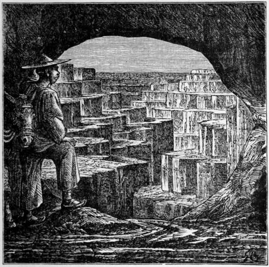
View over the Loess-clefts from the Han-sing ling Pass, Shansí. From Richthofen.
THE PROVINCE OF HONAN.
The province of Honan (i.e., South of the River) comprises some of the most fertile parts of the Plain, and, on account of its abundance and central position, early received the name of Chung Hwa Tí, or the ‘Middle Flowery Land,’ afterwards enlarged into Chung Kwoh, or ‘Middle Kingdom.’ Its form is an irregular triangle, and its size nearly the same as Shantung; it has Shansí and Chihlí on the north, Nganhwui on the south-east, Hupeh on the south and south-west, and Shensí on the west, bordering also on Shantung and Kiangsu. This area is divided into three basins, that of the Yellow River in the north, of the Hwai River on the south, and the Han River on the south-west; the last two are separated by a marked range of mountains, the Fuh-niu shan, which is regarded as the eastern terminus of the Kwănlun Mountains; it is about 300 miles long, and its eastern end is near Jü-ning fu. This range maintains an elevation of 4,000 to 6,000 feet, and is crossed at Nanchau, where a remarkable natural pass about 30 miles long, rising to 1,200 or 1,500 feet, affords the needed facilities for trade and travel between the central and northern provinces. The Peh and Tan rivers drain its southern slopes into the Han, and the eastern sides are abundantly watered by the numerous branches of the Hwai River as they flow into Hungtsih Lake. The northern portion of Honan along the Yellow River is level, fertile and populous, forming one of the richest portions of the province.
For its climate, productions, literary reputation, historical associations, and variety of scenery, this province takes a prominent rank. The earliest records of the Black-haired race refer to this region, and the struggles for dominion among feudal and imperial armies occurred in its plains. Its present difficulty of access from the coast will ere long be overcome by railroads, when its capabilities may be further developed, and the cotton, hemp, iron, tutenag, silk and coal be increased for exportation. The people at present consume their own food and manufactures, and only require a good demand to increase the quality and amounts and exchange them for other things. The three prefectures north of the Yellow River are low-lying; through these the waters of that river have recently found their way into the River Wei and thence to the Gulf of Pechele, at Măng-tsin or east of it; the gradual rise of the bed renders their levels nearly the same, while it makes the main stream so broad and shallow that it is of little use for navigation. These plains are traversed by wheelbarrows and carts, whose drivers and trundlers form a vast body of stalwart men constantly going about in their employment from one city to another.
Kaifung fu, or Pien-liang, the capital, is situated about a league from the southern bank of the Yellow River, whose bed is here elevated above the adjacent country. It was the metropolis from A.D. 960 to 1129, and has often suffered from attacks of armies as well as from inundations. The dikes are mostly on the northern shore, and exhibit the industry and unavailing efforts of the people for scores of leagues. During the period of the Manchu conquest Kaifung was defended by a loyal general, who, seeing no other resource against the invaders, broke down the embankments to drown them, by which manœuvre upwards of 300,000 of the inhabitants perished. The city was rebuilt, but it has not attained to its ancient splendor, if credit can be given to the Statistics of Kaifung, in which work it is described as having been six leagues in circuit in the twelfth century, approached by five roads, and containing numerous palaces, gardens, and government houses. The valley of the River Loh lies between the Yellow River and the Fuh-niu Mountains, a fertile, populous region wherein many of the remarkable events of Chinese history were enacted. Loh-yang, near Honan, was the metropolis at three different intervals, and probably further researches here will bring to light many ancient relics; rock-cut temples and old inscriptions, with graceful bas-reliefs, near the natural gate of Lung-măn, where the road crosses Sung shan, have already been seen. Owing to the direction of the roads leading through this region from the south and east, and the passes for travel towards the north-west, it will form a very important centre of trade in the future of Central Asia and western China.
The province of Kiangsu is named from the first syllable of the capital, Kiangning, joined to Su, part of the name of the richest city, Suchau. It lies along the sea-coast, in a north-westerly direction, having Shantung on the north, Nganhwui on the west, and Chehkiang on the south. The area is about 45,000 square miles, equalling Pennsylvania or a little less than England by itself. It consists, with little interruption, of level tracts interspersed with lakes and marshes, through which flow their two noble rivers, which as they are the source of the extraordinary fertility of this region, so also render it obnoxious to freshes, or cover the low portions with irreclaimable morasses. The region of Kiangnan is where the beauty and riches of China are most amply displayed; “and whether we consider,” remarks Gutzlaff, speaking of this and the adjoining province, “their agricultural resources, their great manufactures, their various productions, their excellent situation on the banks of these two large streams, their many canals and tributary rivers, these two provinces doubtless constitute the best territory of China.” The staple productions are grain, cotton, tea, silk, and rice, and most kinds of manufactures are here carried to the greatest perfection. The people have an exceptional reputation for intelligence and wit, and although the province has long ceased to possess a court, its cities still present a gayer aspect, and are adorned with better structures than any others in the empire. This province was the scene of the dreadful ravages of the Tai-ping rebellion, and large districts are still desolate, while their cities lie waste.
Probably no other country of equal extent is better watered than Kiangsu. The Great River, the Grand Canal, many smaller streams and canals, and a succession of lakes along the line of the canal, afford easy communication through every part. The sea-coast has not been surveyed north of the Yangtsz’, where it is unapproachable in large vessels; dykes have been constructed in some portions to prevent the in-flow of the ocean. The largest lake is the Hungtsih, about two hundred miles in circumference. South of it lies Kauyu Lake, and on the eastern side of the canal opposite is Pauying Lake, both of them broad sheets of water. Numerous small lakes lie around them. Tai hu, or ‘Great Lake,’ lies partly in Kiangsu and partly in Chehkiang, and is the largest in the province. Its borders are skirted by romantic scenery, while its bosom is broken by numerous islets, affording convenient resort to the fishermen who get their subsistence from its waters.
CITY OF NANKING.
Kiangning fu (better known abroad as Nanking), the capital of the province, is situated on the south shore of the Yangtsz’, 194 miles from Shanghai. It was the metropolis from A.D. 317 to 582, and again for 35 years during the Ming dynasty (1368-1403). This city is the natural location of an imperial court, accessible by land and water from all quarters, and susceptible of sure defence. When the Tai-pings were expelled in 1865, the city was nearly destroyed, and has since that date only slowly revived. When Hungwu made it his capital, he strengthened the wall around it, inclosing a great area, 35 miles in circuit, which was never fully covered with buildings, and at present has a most ruinous appearance. Davis remarks the striking resemblance between Rome and Nanking, the area within the walls of both being partially inhabited, and ruins of buildings lying here and there among the cultivated fields, the melancholy remains of departed glory. Both of them, however, have now brighter prospects for the future.
The part occupied by the Manchus is separated by a cross wall from the Chinese town. The great extent of the wall renders the defence of the city difficult, besides which it is overlooked from the hills on the east, from one of which, the Chung shan, a wide view of the surrounding country can be obtained. On this eastern face are three gates; the land near the two toward the river is marshy, and the gates are approached on stone causeys. A deep canal runs up from the river directly under the walls on the west, serving to strengthen the approaches on that side. Nanking is laid out in four rather wide and parallel avenues intersected by others of less width; and though not so broad as those of Peking, are on the whole clean, well-paved, and bordered with handsomely furnished shops.
The only remarkable monuments of royalty which remain are several guardian statues situated not far from the walls. These statues form an avenue leading up to the sepulchre where the Emperor Hungwu was buried about 1398. They consist of gigantic figures like warriors cased in armor, standing on either side of the road, across which at intervals large stone tablets are extended, supported by great blocks of stone instead of pillars. Situated at some distance are a number of rude colossal figures of horses, elephants, and other animals, all intended to represent the guardians of the mighty dead.[46]
PORCELAIN TOWER OF NANKING.
Nothing made Nanking more celebrated abroad than the Porcelain Tower, called Pao-ngăn tah, or the ‘Recompensing Favor Monastery,’ which stood pre-eminent above all other similar buildings in China for its completeness and elegance, the material of which it was built, and the quantity of gilding with which its interior was embellished. It was erected by Yungloh to recompense the great favor of her majesty the Empress, and occupied 19 years (1411-1430) in its construction. It was maintained in good condition by the government, and three stories which had been thrown down by lightning in 1801 were rebuilt. The Tai-pings blew it up and carried off the bricks in 1856, fearing lest its geomantic influences should work against the success of their cause. As to its dimensions: Its form was octagonal, divided into nine equal stories, the circumference of the lower story being 120 feet, decreasing gradually to the top. Its base rested upon a solid foundation of brick-work ten feet high, up which a flight of twelve steps led into the tower, whence a spiral staircase of 190 steps carried the visitor to the summit, 261 feet from the ground. The outer face was covered with slabs of glazed porcelain of various colors, principally green, red, yellow, and white, the body of the edifice being brick. At every story was a projecting roof, covered with green tiles; from each corner and from the top of these roofs were suspended bells, numbering 150 in all.
This beautiful structure was visited in 1852 by Dr. Charles Taylor, an American missionary, who has left a full account of his observations.[47] It was to have been raised to an altitude of 329 feet and of thirteen stories, but only nine were built; careful measurement gave 261 feet as its height, 8½ feet its thickness at top, and 12 feet at the base, where it was 96 feet 10 inches in diameter. The facing was of bricks made of fine porcelain clay; the prevailing color was green, owing to the predominance of the tiles on the numerous stories. The woodwork supporting these successive roofs was strong, curiously carved and richly painted. The many-colored tiles and bricks were highly glazed, giving the building a gay and beautiful appearance, that was greatly heightened when seen in the reflected sunlight. When new it had 140 lamps, most of them hanging outside; and a native writer says “that when lighted they illumine the 33 heavens, and detect the good and evil among men, as well as forever ward off human miseries.” The destruction of a building like this, from mere fanciful ideas, goes far to explain the absence of all old or great edifices in China.
Nanking has extensive manufactories of fine satin and crape, Nankeen cotton cloth, paper and ink of fine quality, and beautiful artificial flowers of pith paper. In distant parts of the empire, any article which is superior to the common run of workmanship, is said to be from Nanking, though the speaker means only that it was made in that region. It is renowned, too, for its scholars and literary character, and in this particular stands among the first places of learning in the country. It is the residence of the governor-general of three provinces, and consequently the centre of a large concourse of officials, educated men, and students seeking for promotion; these, with its large libraries and bookstores, all indicating and assisting literary pursuits, combine to give it this distinguished position. In the monastery on Golden Island, near Chinkiang, a library was found by the English officers, but there was no haste in examining its contents, as they intended to have carried off the whole collection, had not peace prevented.
THE CITIES OF SUCHAU AND CHINKIANG.
The city of Suchau now exceeds Nanking in size and riches. It is situated on islands lying in the Ta hu, and from this sheet of water many streams and canals connect the city with most parts of the department. The walls are about ten miles in circumference; outside of them are four suburbs, one of which is said to extend ten miles, besides which there is an immense floating population. The whole space includes many canals and pools connected with the Grand Canal and the lake, and presented in 1859 a scene of activity, industry, and riches which could not be surpassed elsewhere in China. The population probably then exceeded a million, including the suburbs. It lies north-west of Shanghai, the way passing through a continual range of villages and cities; the environs are highly cultivated, producing cotton, silk, rice, wheat, fruits, and vegetables. It was captured in 1860 by the rebels, and when retaken in 1865 was nearly reduced to a heap of ruins. It is, however, rapidly reviving, as the loss of life was comparatively small.
The Chinese regard this as one of their richest and most beautiful cities, and have a saying, “that to be happy on earth, one must be born in Suchau, live in Canton, and die in Liauchau, for in the first are the handsomest people, in the second the most costly luxuries, and in the third the best coffins.” It has a high reputation for its buildings, the elegance of its tombs, the picturesque scenery of its waters and gardens, the politeness and intelligence of its inhabitants, and the beauty of its women. Its manufactures of silk, linen, cotton, and works in iron, ivory, wood, horn, glass, lackered-ware, paper, and other articles, are the chief sources of its wealth and prosperity; the kinds of silk goods produced here surpass in variety and richness those woven in any other place. Vessels can proceed up to the city by several channels from the Yangtsz’ kiang, but junks of large burden anchor at Shanghai, or Sungkiang; the whole country is so intersected by natural and artificial water-courses, that the people have hardly any need for roads and carts, but get about in barrows and sedans. Small steamers find their way to every large village at high tide.
Chinkiang, situated at the junction of the Grand Canal with the Yangtsz’ kiang, was captured by the British in July, 1842, at a great loss of life to its defenders; the Manchu general Hai-ling, finding the city taken, seated himself in his office, and set fire to the house, making it his funeral pyre. Its position renders it the key of the country, in respect to the transport of produce, taxes and provisions for Peking, inasmuch as when the river and canal are both blockaded, the supplies for the north and south are to a great extent intercepted. In times of peace the scenes at the junction afford a good exhibition of the industry and trade of the people. Barrow describes, in 1794, “the multitude of ships of war, of burden and of pleasure, some gliding down the stream, others sailing against it; some moving by oars, and others lying at anchor; the banks on either side covered with towns and houses as far as the eye could reach; as presenting a prospect more varied and cheerful than any that had hitherto occurred. Nor was the canal, on the opposite side, less lively. For two whole days we were continually passing among fleets of vessels of different construction and dimensions.”[48]
The country in the vicinity is well cultivated, moderately hilly, and presents a characteristic view of Chinese life and action. “On the south-east, the hills broke into an undulating country clothed with verdure, and firs bordering upon small lakes. Beyond, stretched the vast river we had just ascended. In the other direction, the land in the foreground continued a low and swampy flat, leaving it difficult at a little distance to determine which of the serpentine channels was the main branch; there were innumerable sheets of water, separated by narrow mounds, so that the whole resembled a vast lake, intersected by causeways. Willows grew along their sides, and dwellings were erected on small patches somewhat higher than the common surface.”[49] This whole country was the scene of dreadful fighting for many years. Between the Imperialists and Tai-pings the city was totally destroyed, so that in 1861 hardly a house was left. It is now regaining its natural trade and prosperity.
Near the mouth of the Grand Canal is Kin shan, or Golden Island,[50] a beautiful spot, covered with temples and monastic establishments. A pagoda crowns the summit, and there are many pavilions and halls, of various sizes and degrees of elegance, on its sides and at the base, many of them showing their imperial ownership by the yellow or green tiling. Since the river has been open to traffic, and the devastations of the Tai-pings have ceased, the priests have returned in small numbers to their abodes, but the whole settlement is a poor mockery of its early splendor. A similar one, rather larger, is found at Siung shan, or Silver Island, below Chinkiang; it is, however, on a less extensive scale, though in a beautiful situation. Priests are the only occupants; temples and palaces the principal buildings, surrounded by gardens and bowers. Massive granite terraces, decorated with huge stone monsters, are reached from the water by broad flights of steps; fine temples, placed to be seen, and yet shaded by trees, open pavilions, and secluded summer-houses, give it a delightful air of retreat and comfort, which a nearer inspection sadly disappoints.
The banks of the Yangtsz’ during the 250 miles of its course through this province, are uniformly low, and no towns of importance occur close to them, as they would be exposed to the floods. The vast body of water, with its freight of millions of tons of silt goes on its way in a quiet equable current into the Yellow Sea. The dense population of the prefectures on the south bank, contrasted with the sparseness of the region between the Canal and seashore on the north side, indicate the comparative barrenness of the latter, and the difficulty of cultivating marshy lands so nearly level with the sea.
SHANGHAI.
The largest seaport in Kiangsu is Shanghai (i.e., Approaching the Sea), now become one of the leading emporia in Asia. It lies on the north shore of the Wusung River, about fourteen miles from its mouth, in lat. 31° 10′ N., and long. 121° 30′ E., at the junction of the Hwang-pu with it, and by means of both streams communicates with Suchau, Sungkiang, and other large cities on the Grand Canal; while by the Yangtsz’ it receives produce from Yunnan and Sz’chuen. In these respects its position resembles that of New Orleans.
The town of Wusung is at the mouth of that river, here about a mile wide; and two miles beyond lies the district town of Paushan. The wall of Shanghai is three miles in circuit, through which six gates open into extensive suburbs; around the ramparts flows a ditch twenty feet wide. The city stands in a wide plain of extraordinary fertility, intersected by numerous streamlets, and affording ample means of navigation and communication; its population is estimated to be at present over 500,000, but the data for this figure are rather imperfect. Since it was opened to foreign commerce in 1843, the growth of the town has been rapid in every element of prosperity, though subject to great vicissitudes by reason of the rebellion which devastated the adjoining country. Its capture by the insurgents in 1851, and their expulsion in February, 1853, with the destruction of the eastern and southern suburbs in 1860, have been its chief disasters since that date. The native trade has gradually passed from the unwieldy and unsafe junks which used to throng the Hwang-pu east of the city, into steamers and foreign craft, and is now confined, so far as the vessels are concerned, to the inland and coast traffic in coarse, cheap articles.
Shanghai city itself is a dirty place, and poorly built. The houses are mostly made of bluish square brick, imperfectly burned; and the walls are constructed in a cellular manner by placing bricks on their edges, and covering them with stucco. The streets are about eight feet wide, paved with stone slabs, and in the daytime crowded with people. Silk and embroidery, cotton, and cotton goods, porcelain, ready-made clothes, beautiful skins and furs, bamboo pipes of every size, bamboo ornaments, pictures, bronzes, specimens of old porcelain, and other curiosities, to which the Chinese attach great value, attract the stranger’s notice. Articles of food form the most extensive trade of all; and it is sometimes a difficult matter to get through the streets, owing to the immense quantities of fish, pork, fruit, and vegetables, which crowd the stands in front of the shops. Dining-rooms, tea-houses, and bakers’ shops, are met with at every step, from the poor man who carries around his kitchen or bakehouse, altogether hardly worth a dollar, to the most extensive tavern or tea-house, crowded with customers. For a few cash, a Chinese can dine upon rice, fish, vegetables, and tea; nor does it matter much to him, whether his table is set in the streets or on the ground, in a house or on a deck, he makes himself merry with his chopsticks, and eats what is before him.[51] The buildings composing the Ching-hwang miao, and the grounds attached to this establishment, present a good instance of Chinese style and taste in architecture. Large warehouses for storing goods, granaries, and temples, are common; but neither these, nor the public buildings, present any distinguishing features peculiar to this city alone.
The contrast between the narrow, noisome and reeking parts of the native city, and the clean, spacious, well-shaded and well-paved streets and large houses of the foreign municipalities, is like that seen in many cities in India. The Chinese are ready enough to enjoy and support the higher style of living, but they are not yet prepared to adopt and maintain similar improvements among themselves. The difficulty of being sure of the co-operation of the rulers in municipal improvements deters intelligent natives from initiating even the commonest sanitary enterprise of their foreign neighbors.
The remaining cities and districts of Kiangsu present nothing worthy of special remark. The Grand Canal runs from north to south, and affords a safe and ample thoroughfare for multitudes of boats in its entire length. Tsing-kiang-pu and Hwai-ngan, near the old Yellow River, receive the traffic from the north and Hungtsih Lake, while Yangchau near the Yangtsz’ River, takes that going north. In this part of the channel, constant dyking has resulted in raising the banks; the city of Hwai-ngan, for example, lies below the canal which brings trade to its doors, and may one day be drowned by its benefactor. Salt is manufactured in the districts south of the Yellow River, where the people cultivate but rare patches of arable land.
The island of Tsungming, at the mouth of the Yangtsz’, is about sixty miles long, and sixteen wide, containing over nine hundred square miles, and is gradually enlarging by the constant deposits from the river; it is flat, but contains fresh water. It is highly cultivated and populous, though some places on the northern side are so impregnated with salt, and others so marshy, as to be useless for raising food. This island produces a variety of kaoliang or sorghum (Holcus), which is sweet enough to furnish syrup, and is grown for that purpose in the United States.
POSITION AND TOWNS OF NGANHWUI PROVINCE.
The province of Nganhwui was so named by combining the first words in its two large cities, Nganking and Hwuichau, and forms the south-western half of Kiangnan; it is both larger and more uneven than Kiangsu, ranges of hills stretching along the southern portions, and between the River Hwai and the Yangtsz’. It lies in the central and southern parts of the Plain, north of Kiangsí, west of Kiangsu and Chehkiang, and between them and Honan and Hupeh. Its productions and manufactures, the surface, cultivation of the country, and character of the people, are very similar to those of Kiangsu, but the cities are less celebrated. The terrible destruction of life in this province during the Tai-ping rule has only been partially remedied by immigration from other provinces; it will require years of peace and industry to restore the prosperous days of Taokwang’s reign.
The surface of the country is naturally divided into that portion which lies in the hilly regions around Hwuichau and Ningkwoh connected with the Tsientang River, the central plain of the Yangtsz’ with its short affluents, and the northern portion which the River Hwai drains. The southern districts are superior for climate, fertility, and value of their products to most parts of the Empire; and the numerous rivulets which irrigate and open their beautiful valleys to traffic with other districts, render them attractive to settlers. No expense has been spared in erecting and preserving the embankments along the streams, whose waters are thereby placed at the service of the farmers.
The Great River passes through the south from south-west to north-east; several small tributaries flow into it on both banks, one of which connects with Chau hu, or Nest Lake, in Luchau fu, the principal sheet of water in the province. The largest section is drained by the River Hwai and its branches, which flow into Hungtsih Lake; most of these are navigable quite across to Honan. The productions comprise every kind of grain, vegetables, and fruit known in the Plain; most of the green tea districts lie in the south-eastern parts, particularly in the Sunglo range of hills in Hwuichau prefecture. Silk, cotton, and hemp are also extensively raised; but excepting iron, few metals are brought to market.
The provincial capital, Nganking or Anking, lies close to the northern shore of the Kiang. Davis describes the streets as very narrow, and the shops as unattractive; the courts and gateways of many good dwelling-houses presented themselves as he passed along the streets. “The palace of the governor we first took for a temple, but were soon undeceived by the inscriptions on the huge lanterns at the gateway. These official residences seldom display any magnificence. The pride of a Chinese officer of rank consists in his power and station, and as the display of mere wealth attracts little respect, it is neglected more than in any country of the world. The best shops that we saw were for the sale of horn lanterns and porcelain. They possess the art of softening horn by the application of a very high degree of moist heat, and extending it into thin laminæ of any shape. These lamps are about as transparent as ground-glass, and, when ornamented with silken hangings, have an elegant appearance.” During the fifty years since his visit, this large city has been the sport of prosperous and adverse fortunes, and is now slowly recovering from its demolition during the Tai-ping rebellion. It is situated on rising ground near the base of a range of hills far in the north, the watershed of two basins.
The banks of the river, between Nanking and Nganking, a distance of 300 miles, are well cultivated, and contain towns and villages at short intervals. The climate, the scenery, the bustle on the river near the towns, and the general aspect of peaceful thrift along this reach, makes it on ordinary occasions one of the bright scenes in China. Wuhu hien, about sixty miles above Nanking, lies near the mouth of the Hwangchi, a stream connecting it with the back country, and making it the mart for much of that trade. It was next in importance to Chinkiang, but its sufferings between the rebels and imperialists nearly destroyed it. The revival in population and trade has been encouraging, and its former importance is sure to revive.
Hwuichau (or in Cantonese, Fychow) is celebrated, among other things, for its excellent ink and lackered-ware. Fungyang (i.e., the Rising Phœnix), a town lying north-west of Nanking, on the River Hwai, was intended, by Hungwu, the founder of the Ming dynasty, to have been the capital of the Empire instead of Nanking, and was thus named in anticipation of its future splendor.
KIANGSÍ PROVINCE.
The province of Kiangsí (i.e., West of the River) lies south of Nganhwui and Hupeh, between Chehkiang and Fuhkien on the east, and Hunan on the west, reaching from the Yangtsz’ to the Mei ling on the south. Its form is oblong, and its entire area is made up of the beautiful basin of the Kan kiang, including all the affluents and their minor valleys. The hilly portions form part of the remarkable series of mountainous ridges, which cover all south-eastern and southern China, an area of about 300,000 square miles, extending from Ningpo south-westerly to Annam. It is made up of ranges of short and moderate hills, cut up by a complicated net of water-courses, many of which present a succession of narrow defiles and gentle valleys with bottom lands from five to twelve miles wide. That part of this region in Kiangsí has an irregular watershed on the east, separating it from the Min basin, and a more definite divide on the west from Hunan and its higher mountains. The province entire is a little larger than all New England, or twice the size of Portugal, but, in population, vastly exceeds those countries. The surface of the land is rugged, and the character of the inhabitants partakes in some respects of the roughness of their native hills. It is well watered and drained by the River Kan and its tributaries, most of which rise within the province; the main trunk empties into Poyang Lake by numerous mouths, whose silt has gradually made the country around it swampy. For many miles on its eastern and southern banks extends an almost uninhabitable marsh, presenting a dreary appearance. The soil, generally, is productive, and large quantities of rice, wheat, silk, cotton, indigo, tea, and sugar, are grown and exported. It shares, in some degree, the manufactures of the neighboring provinces, especially in Nankeen cloth, vast quantities of which are woven here, but excels them all in the quality and amount of its porcelain. The mountains produce camphor, varnish, oak, banian, fir, pine, and other trees; those on the west are well wooded, but much of the timber has been carried away during the late rebellion, and left the hillsides bare and profitless.
TOWNS AND PRODUCTIONS OF KIANGSÍ.
Nanchang, the provincial capital, lies near the southern shore of the Poyang Lake; the city walls are six miles in circuit, and accessible by water from all sides. The character of its population is not favorable among their countrymen, and owing to the difficulty of reaching it from the Yangtsz’, it escaped the ruin and rapine which befel Kiukiang. Small steamers can come up to its jetties, but as the tea and porcelain are shipped on the south-east side of the lake, Nanchang is not likely to become a large mart; few of the cities above it can ever be reached by steamers. Barrow estimated that there were, independent of innumerable small craft, 100,000 tons of shipping lying before the place. The banks of the Kan kiang, near the lake, are flat, and not highly cultivated, but the scenery becomes more varied and agreeable the further one ascends the stream; towns and villages constantly come in sight, and the cultivation, though not universal, is more extended. Among other sights on this river are the bamboo water-wheels, which are so built on the steep banksides, that the buckets lift their freight 20 or 25 feet, and pour it out in a ceaseless stream over the fields. The flumes thrown out into the stream to turn a stronger current on the wheel, often seriously interfere with navigation. Many pagodas are seen on either bank of this water-course, some of them undoubtedly extremely old. As the voyager ascends the river, several large cities are passed, as Linkiang, Kih-ngan, Kanchau, and Nan-ngan (all capitals of departments), besides numerous towns and villages; so that if the extent of this river and the area of the valley it drains be considered, it will probably bear comparison with that of any valley in the world for populousness, amount and variety of productions, and diligence of cultivation.
Beyond Kihngan are the Shihpah tan, or ‘Eighteen Rapids,’ which are torrents formed by ledges of rocks running across the river, but not of such height or roughness as to seriously obstruct the navigation except at low water. The shores in their vicinage are exceedingly beautiful. The transparency of the stream, the bold rocks fringed with wood, and the varied forms of the mountains, call to mind those delightful streams that are discharged from the lakes and north counties of England. The hilly banks are in many places covered with the Camellia oleifera, whose white blossoms give them the appearance of snow, when the plant is in flower. Kanchau is the town where large boats are obliged to stop; but Nan-ngan is at the head of navigation, about three hundred miles from the lake, where all goods for the south are debarked to be carried across the Mei ling, or ‘Plum Pass.’
Within the department of Jauchau in Fauliang hien, east of Poyang Lake, are the celebrated porcelain manufactories of Kingteh chin, named after an Emperor of the Sung dynasty, in whose reign, A.D. 1004, they were established. This mart still supplies all the fine porcelain used in the country, but was almost wholly destroyed during the rebellion, the kilns broken up, and the workmen dispersed to join the rebels or die from want. The million of workmen said to have been employed there thirty years ago are now only gradually resuming their operations, and slowly regaining their prosperity. The approach to the spot is announced by the smoke, and at night it appears like a town on fire, or a vast furnace emitting flames from numerous vents, there being, it is said, five hundred kilns constantly burning. Kingteh chin stands on the river Chang in a plain flanked by high mountains, about forty miles north-east from Jauchau, through which its ware is distributed over the empire.
Genius in China, as elsewhere, renders a place illustrious, and few spots are more celebrated than the vale of the White Deer in the Lü hills, near Nankang, on the west side of Lake Poyang, where Chu Hí, the great commentator of Confucius, lived and taught, in the twelfth century. It is a secluded valley about seven miles from the city, situated in a nook by the side of a rivulet. The unpretending buildings are comprised in a number of different courts, evidently intended for use rather than show. In one of the halls, the White Deer is represented, and near by a tree is pointed out, said to have been planted by the philosopher’s own hand. This spot is a place of pilgrimage to Chinese literati at the present day, for his writings are prized by them next to their classics. The beauty and sublimity of this region are lauded by Davis, and its praises are frequent themes for poetical celebration among native scholars.[52]
The maritime province of Chehkiang, the smallest of the eighteen, lies eastward of Kiangsí and Nganhwui, and between Kiangsu and Fuhkein north and south, and derives its name from the river Cheh or ‘Crooked,’ which runs across its southern part. Its area is 39,000 square miles, or nearly the same as Ohio; it lies south-east of the plain at the end of the Nan shan, and for fertility, numerous water-courses, rich and populous cities, variety of productions, and excellence of manufactures, is not at all inferior to the larger provinces. Baron Richthofen’s letter to the Shanghai Chamber of Commerce, July 25, 1871, contains a good account of its topography. The whole province produces cotton, silk, tea, rice, ground nuts, wheat, indigo, vegetable tallow (stillingia), and pulse, in abundance. It possesses within its limits every requisite for the food and clothing of its inhabitants, while the excellence of its manufactures insures it in exchange a supply of the luxuries of other regions.
NATURAL FEATURES OF CHEHKIANG.
The rivers in Chehkiang rise in the province; and, as might be inferred from the position of the hills, their course is generally short and the currents rapid. Fourteen principal streams are enumerated, of which the Tsientang is the most important. The main branch of this river rises in the southern districts in two head-waters, which join at Küchau fu and run thence into Hangchau Bay. The bore which comes up into this river fifteen miles, as far as Hangchau, is the only one along the coast. As its wall of water approaches the city, the junks and boats prepare by turning their bows to meet it, and usually rise over its crest, 6 or 10 feet at times, without mishap. The basin of the Tsientang River measures nearly half of the province; by means of rafts and boats the people transport themselves and their produce for about 300 miles to its headwaters. The valley of Lanki is the largest of the bottom lands, 140 miles long and 5 to 15 wide, and passes north through a gorge 70 miles in length into the lower valley, where it receives the Sin-ngan River from the west in Nganhwui, and thus communicates with Hwuichau at times of high water. It is just fitted for the rafting navigation of the region, and by means of its tortuous channels each one of the 29 districts in its entire basin can be reached by water.
The forest and fruit trees of Chehkiang comprise almost every valuable species known in the eastern provinces. The larch, elcococcus, camphor, tallow, fir, mulberry, varnish, and others, are common, and prove sources of wealth in their timber and products. The climate is most salubrious; the grains, vegetables, animals, and fishes, furnish food; while its beautiful manufactures of silk are unrivalled in the world, and have found their way to all lands. Hemp, lackered- and bamboo-wares, tea, crockery, paper, ink, and other articles, are also exported.
The inhabitants emulate those in the neighboring regions for wealth, learning, and refinements, with the exception of the hilly districts in the south bordering on Kiangsí and Fuhkien. The dwellers of these upland valleys are shut out by position and inclination, so that they form a singularly clannish race. Their dialects are peculiar and very limited in range, and each group of villagers suspects and shuns the others. They are sometimes rather turbulent, and in some parts the cultivation of the mountain lands is interdicted, and a line of military posts extends around them in the three provinces, in order to prevent the people from settling in their limits; though the interdiction does not forbid cutting the timber growing there.[53]
HANGCHAU AND ITS ENVIRONS.
Hangchau, the capital of the province, lies in the northern part, less than a mile from the Tsientang. The velocity of this stream indicates a rapid descent of the country towards the ocean, but it discharges very little silt; the tide rises six or seven feet opposite the city, and nearly thirty at the mouth.
Only a moiety of the inhabitants reside within the walls of the city, the suburbs and the waters around them supporting a large population. A portion of the space in the north-western part is walled off for the accommodation of the Manchu garrison, which consists of 7,000 troops. The governor-general of Chehkiang and Fuhkien has an official house here, as well, also, as the governor of the province, but since the increased importance of Fuhchau, he seldom resides in this city; these, with their courts and troops, in addition to the great trade passing through, render it one of the richest and most important cities in the empire. The position is the most picturesque of any of the numerous localities selected by the Chinese for their capital. It lies in full view of the ocean, and from the hill-top in the centre a wide view of the plains south and east is obtained. The charming lake, Si Hu, and the numerous houses on its shores, with the varied scenery of the hills, copses, glades, and river banks, all highly cultivated, within a radius of ten miles, fully bear out the praises of the Chinese as to its singular beauty. Marco Polo lavishes all his admiration upon its size, riches, manufactures, and government, from which it is to be inferred that it suffered little in the Mongolian conquest. He visited the place when governor of Yangchau in 1286, and enthusiastically describes it as “beyond dispute the finest and the noblest in the world.”[54] The Chinese have a proverb—Shang yu tien tang: Hia yu Su Hang—the purport of which is that Hangchau and Suchau are fully equal to paradise; but the comparison of the Venetian traveller gives one a poorer idea of the European cities of his day, than it does of the magnificence of the Chinese, to those who have seen them. The streets are well-paved, ornamented with numerous honorary tablets erected to the memory of distinguished individuals, and agreeably interrupting the passage through them. The long main street extending along the Grand Canal into and through the city, thence out by the Tsientang, was, before its ruthless demolition by the Tai-pings in 1863, probably one of the finest streets in the whole Empire. The shops and warehouses, in point of size and stock of goods contained in them, might vie with the best in London. In population, luxury, wealth, and influence this city rivals Suchau, and for excellence of manufactures probably exceeds the latter place. Were Hangchau easily reached by sea, and had it ample harbors, it would engross the trade of the eastern coast; but furious tides (running sometimes 11½ knots an hour); the bore jeoparding passage-boats and other small crafts; sand banks and quicksands;—these present insuperable difficulties to the commerce by the ocean.
This city was the metropolis of the country during the nine latter princes of the Sung dynasty (1129 to 1280), when the northern parts were under dominion of the tribe of Kin Tartars. One cause of celebrity is found in the beauty of its environs, especially those near the Si Hu, or West Lake, an irregular sheet of water about 12 miles in circuit. Barrow observes that “the natural and artificial beauties of this lake far exceeded anything we had hitherto had an opportunity of seeing in China. The mountains surrounding it were lofty, and broken into a variety of forms that were highly picturesque; and the valleys were richly clothed with trees of different kinds, among which three species were remarkably striking, not only by their intrinsic beauty, but also by the contrast they formed with themselves and the rest of the trees of the forest. These were the camphor and tallow trees, and the arbor vitæ. The bright, shining green foliage of the first, mingled with the purple leaves of the second, and over-topped by the stately tree of life, of the deepest green, produced a pleasing effect to the eye; and the landscape was rendered still more interesting to the mind by the very singular and diversified appearance of several thousand repositories of the dead upon the sloping sides of the inferior hills. Here, as well as elsewhere, the sombre and upright cypress was destined to be the melancholy companion of the tombs.
“Higher still, among the woods, avenues had been opened to admit of rows of small blue houses, exposed on white colonnades, which, on examination, were also found to be mansions of the dead. Naked coffins, of extraordinary thickness, were everywhere lying on the surface of the ground. The margins of the lake were studded with light aerial buildings, among which one of more solidity and greater extent than the rest was said to belong to the emperor. The grounds were inclosed with brick walls, and mostly planted with vegetables and fruit trees; but in some there appeared to be collections of such shrubs and flowers as are most esteemed in the country.”[55]
Staunton speaks of the lake as a beautiful sheet of water, perfectly pellucid, full of fish, in most places shallow, and ornamented with a great number of light and fanciful stone bridges, thrown across the arms of the lake as it runs up into the hills. A stone tower on the summit of a projecting headland attracted attention, from its presenting a different architecture from that usually seen in Chinese buildings. This tower, called the Lui Fung tah, lit. ‘Tower of the Thunder Peak’ (not Thundering Wind, as Staunton renders it), from the hill being at first owned by Mr. Lui, was built about A.D. 950, and is to-day a solid structure, though much ruined. It has now four stories, and is about 120 feet high; something like a regular order is still discernible in the moldering cornices. The legend of the White Snake is associated with this structure, and people constantly carry away pieces of its bricks as charms.
An interesting corroboration of this account is given by Polo, who says, “Inside the city there is a lake which has a compass of some 30 miles; and all around it are erected beautiful palaces and mansions, of the richest and most exquisite structure that you can imagine, belonging to the nobles of the city. There are also on its shores many abbeys and churches of the idolaters. In the middle of the lake are two islands, on each of which stands a rich, beautiful and spacious edifice, furnished in such a style as to seem fit for the palace of an emperor. And when any one of the citizens desired to hold a marriage feast, or to give any other entertainment, it used to be done at one of these palaces.”[56]
The splendor and size of the numerous Buddhist temples in and around Hangchau attracted travellers to the city more even than did its position; these shrines have, however, all been destroyed, and their thousands of priests driven away; the Tai-pings left no building untouched. The Yoh Miao stands near the north-west corner of the Si Hu, and contains the tombs of the patriot general Yoh Fi of the Sung dynasty (A.D. 1125), and his son, who were unjustly executed as traitors. Two conical mounds mark their resting places, and separated by a wall, but inside the inclosure are four iron statues cast in a kneeling posture and loaded with chains,—on his right Tsin Kwei and his wife, on the left a judge and general, who subserved Tsin Kwei’s hatred of Yoh Fi by their flagitious conduct. All four are here doing homage and penance to this just man whom they killed, and by the obloquy they receive serve as a warning to other traitors. In a temple, called Ting-tsz’ sz’, not far from the city, the party of the Dutch embassy were well lodged, and attended by three hundred priests. The establishment was in good repair, and besides two guardian monsters more than thirty feet high, near the entrance, contained five hundred images of the Buddhist Arhans, with miniature pagodas of bronze, of beautiful workmanship.
DESCRIPTION OF HANGCHAU.
Hangchau is better known abroad for manufactures of silk than for any other fabrics, but its position at the termination of the Canal may perhaps give its name to many articles which are not actually made there, for Huchau is now a greater dépôt for raw and woven silks. In the northern suburbs lies an irregular basin, forming the southern extremity of the Canal; but between the river and the basin there is no communication, so that all goods brought hither must be landed. The city contains, among other public buildings, a mosque, bearing an inscription in Arabic, stating that it is a “temple for Mussulmen, when travelling, who wish to consult the Koran.”[57] It is higher than the adjacent buildings, and adorned with a cupola, pierced with holes at short intervals. It was spared in 1863, as not being an idolatrous temple. There are also several others in the city, it being a stronghold of Islamism in China. Water communication exists between Hangchau and Yüyau, south-east through Shauhing, and thence to Ningpo, by means of which goods find their way to and from the capital. A good road also runs between the two former cities; indeed, elsewhere in the province the thoroughfares are very creditable; they are laid with broad slabs of granite and limestone, and lead over plains and hills in numberless directions.
NINGPO.
Ningpo fu (‘Peaceful Wave city’) is the next important city in Chehkiang, in consequence of its foreign relations. It is admirably situated for trade and influence, at the junction of three streams, in lat. 29° 55′ N., and long. 121° 22′ E.; the united river flows on to the ocean, eleven and a half miles distant, under the name of the Tatsieh. Opposite the city itself, there are but two streams, but the southern branch again subdivides a few miles south-west of Ningpo. Its population has been variously estimated from one-fourth to one-third of a million, and even more, including the suburban and floating inhabitants. This place was called King-yuen by the Sung, and received its present name from the Mongols. It was captured in 1862 by the insurgents, who were deterred from destroying it by the presence of foreign men-of-war; the prosperity of the mart has since increased. When foreigners first resorted to China for trade, Ningpo soon became a centre of silk and other kinds of commodities; the Portuguese settled there, calling it Liampo, which is the same name. It is, moreover, an ancient city, and its Annals afford full information upon every point interesting to a Chinese antiquarian, though a foreigner soon tires of the many insignificant details mixed up with a few valuable statements.[58]
“The plain in which Ningpo lies is a magnificent amphitheatre, stretching away from twelve to eighteen miles on one side to the base of the distant hills, and on the other to the verge of the ocean. As the eye travels along, it catches many a pleasing object. Turn landward, it will see canals and water-courses, fields and snug farm-houses, smiling cottages, family residences, hamlets and villages, family tombs, monasteries and temples. Turn in the opposite direction, and you perceive a plain country descending toward the ocean; but the river alive with all kinds of boats, and the banks studded with ice-houses, most of all attract the attention. From without the city, and while still upon the ramparts, look within its walls, you will be no less gratified. Here there is nothing European, little to remind you of what you have seen in the west. The single-storied and the double-storied houses, the heavy prison-like family mansions, the family vaults and graveyards, the glittering roofs of the temples, the dilapidated official residences, the deserted literary and examination halls, and the prominent sombre Tower of Ningpo, are entirely Chinese. The attention is also arrested for a moment or two by ditches, canals, and reservoirs of water, with their wooden bridges and stone arches.”[59] Two serious drawbacks to a residence here are the stifling heat of summer and the bad quality of the water.
The circumference of the walls is nearly five miles; they are about twenty-five feet high, fifteen feet wide at the top, and twenty-two at the base, built solidly, though somewhat dilapidated, and overgrown with grass. A deep moat partly surrounds them; commencing at the North gate, it runs on the west, south, and south-east side as far as Bridge gate, a distance of nearly three miles, and is in some places forty yards wide. Its constant use as a thoroughfare for boats insures its repair and proper depth; the other faces of the city are defended by the river. There are six gates, and two sally-ports near the south and west approaches intended for the passage of the boats that ply on the city canals.
On the east is Bridge gate, within which, and near the walls, the English factory was once situated. This opening leads out to the floating bridge; the latter structure is two hundred yards long and five broad, made of planks firmly lashed, and laid upon sixteen lighters closely linked and chained together, but which can be opened. A busy market is held on the bridge, and the visitor following the lively crowd finds his way to an extensive suburb on the opposite side. Ferry boats ply across both streams in vast numbers, adding greatly to the vivacity of the scene. The custom-house is situated beyond the bridge, and this eastern suburb contains several buildings of a religious and public character, lumber-yards, dock-yards, and rows of ice-houses, inviting the notice of the traveller. The environs beyond the north gate are not so thickly settled as those across the rivers; the well cultivated fields, divided and irrigated by numerous water-courses, with scattered hamlets, beguile the visitor in his rambles, and lead him onward.
There are numerous temples and monasteries, and a large variety of assembly-halls, governmental offices, and educational establishments, but none of these edifices are remarkable in an architectural point of view. The assembly-halls or club-houses are numerous, and in their internal arrangements form a curious feature of native society. It is the practice among residents or merchants from other provinces, to subscribe and erect on the spot where they are engaged in business, a temple, dedicated to the patron deity of their native province, in which a few priests are supported, and plays acted in its honor. Sometimes the building is put in charge of a layman, called a “master of ceremonies,” and the current expenses defrayed by subscription. The club-houses are places of resort for travellers from the several provinces or districts, and answer, moreover, to European coffee-houses, in being points where news from abroad is heard and exchanged.
The streets are well paved, and interrupted here and there by honorary portals of considerable size and solidity, which also give variety to an otherwise dull succession of shops and sign-boards, or dead walls. Two small lagoons afford space for some aquatic amusements to the citizens. One called Sun Lake is only a thousand yards in circuit; the other, called Moon Lake, is near the West gate, and has three times its perimeter. Both are supplied by sluices passing through the city gates, while many canals are filled from them, which aid in irrigating the suburbs. Some of the pleasantest residences of the city are built on their banks.
NINGPO, CHINHAI, AND THE ARCHIPELAGO.
Among interesting edifices is the Tien-fung tah (i.e., Heaven-conferred pagoda), a hexagonal seven-storied tower upward of 160 feet high, which, according to the Annals of Ningpo, was first erected 1100 years ago, though during that period it has been destroyed and rebuilt several times. Upon the authority of this work, the tower was constructed before the city itself, and its preservation is considered as connected with the good luck of the place. The visitor mounts to the summit by a flight of narrow stone steps, ascending spirally within the walls.
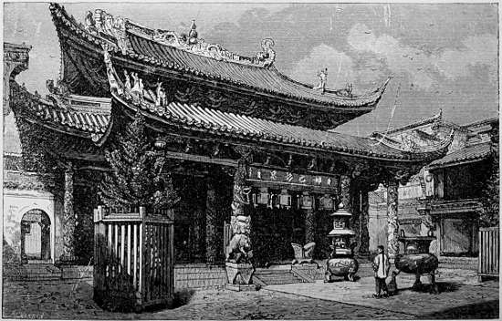
TEMPLE OF THE GODDESS MA TSU-PU, NINGPO.
The most elegant and solid building of the city lies on the water’s edge outside the walls, between the East and Bridge gates; it is a temple dedicated to the marine goddess Ma Tsupu, and was founded by Fuhkien men in the 12th century, but the present structure was erected in 1680, and largely endowed. Its ornaments are elaborate and rich, and its appearance on festival days, gay and animated in an unusual degree. The lanterns and scrolls hanging from the ceiling attract attention by the curious devices and beautiful characters written and drawn on them in bright colors, while the walls are concealed by innumerable drawings.
Chinhai, at the mouth of the river, is so situated by nature and fortified by art, that it commands the passage. Its environs were the scene of a severe engagement between the Chinese and English in October, 1841, on which occasion great slaughter was committed upon the imperial troops. The town lies at the foot of a hill on a tongue of land on the northern bank of the river, and is partly sheltered from the sea on the north by a dyke about three miles long, composed of large blocks of hewn granite, and proving an admirable defence in severe weather. The walls are twenty feet high and three miles in circumference, but the suburbs extend along the water, attracted by, and for the convenience of, the shipping. Merchant ships report here when proceeding up the river, along whose banks the scenery is diversified, while the water, as usual in China, presents a lively scene. Numerous ice-houses are seen constructed of thick stone walls twelve feet high, each having a door on one side and an incline on the other for the removal and introduction of the ice, and protected by straw and a heavily thatched roof.
The Chusan archipelago forms a single district of which Tinghai is the capital; it is divided into thirty-four chwang or townships, whose officers are responsible to the district magistrate. The southern limit of the group is Quesan or the Kiu shan islands, in lat. 29° 21′ N., and long. 121° 10′ E., consisting of eleven islets, the northernmost of which is False Saddle Island; their total number is over a hundred. Tinghai city lies on the southern side of Chan shan or Boat Island, which gives its name on foreign maps to the whole group. It is twenty miles long, from six to ten wide, and fifty one and a half in circumference. The archipelago seems to be the highest portion of a vast submarine plain, geologically connected with the Nan shan range on the Continent and the mountains in Kiusiu and Nippon; it is a pivot for the changes in weather and temperature observed north and south of this point along the coast.
The general aspect of these islands and the mainland, is the same beautiful alternation of hills and narrow valleys, everywhere fertile and easily irrigated, with peaks, cascades, and woodlands interspersed. In Chusan itself the fertile and well-watered valleys usually reach to the sea, and are furnished with dykes along the beach, which convert them into plains of greater or less extent, through which run canals, used both for irrigation and navigation. Rice and barley, beans, yams, sweet potatoes, etc., are grown; every spot of arable soil being cultivated, and terraces constructed on most of the slopes. The view from the tops of the ridges, looking athwart them, or adown their valleys, or to seaward, is highly picturesque. The prevailing rocks belong to the ancient volcanic class, comprising many varieties, but principally clay-stone, trachyte, and compact and porphyritic felspar. The brief occupation of this island by the British forces in 1841 led to no permanent improvement in the condition of the people, and it has neither trade nor minerals sufficient to attract capital thither. Owing in part, perhaps, to this poverty, Tinghai escaped the ravages of the Tai-pings, and has now recovered from the damage sustained by its first capture.
PUTO ISLAND AND ITS TEMPLES.
Puto and a few smaller islands are independent of civil jurisdiction, being ruled by the abbot of the head monastery. This establishment, and that on Golden Island in the Yangtsz’ are among the richest and best patronized of all the Buddhist monasteries in China; both of them have been largely favored by emperors at different periods.
Puto is a narrow islet, 3½ miles long, and lies 1½ miles from the eastern point of Chusan. Its surface is covered with sixty monasteries, pavilions, temples, and other religious buildings, besides grottos and sundry monuments of superstition, in which at least 2,000 idle priests chant the praises of their gods. One visitor describes his landing and ascending “a broad and well-beaten pathway which led to the top of one of the hills, at every crag and turn of which we encountered a temple or a grotto, an inscription or an image, with here and there a garden tastefully laid out, and walks lined with aromatic shrubs, which diffused a grateful fragrance through the air. The prospect from these heights was extremely delightful; numerous islands, far and near, bestudded the main, rocks and precipices above and below, here and there a mountain monastery rearing its head, and in the valley the great temple, with its yellow tiles indicative of imperial distinction, basked like a basilisk in the noonday-sun. All the aid that could be collected from nature and from Chinese art, was here concentrated to render the scene enchanting. But to the eye of the Christian philanthropist it presented a melancholy picture of moral and spiritual death. The only thing we heard out of the mouths of the priests was Ometo Fuh; to every observation that was made, re-echoed Ometo Fuh; and the reply to every inquiry was Ometo Fuh. Each priest was furnished with a rosary which he was constantly counting, and as he counted repeated the same senseless, monotonous exclamation. These characters met the eye at every turn of the road, at every corner of the temples, and on every scrap of paper; on the bells, on the gateways, and on the walls, the same words presented themselves; indeed the whole island seemed to be under the spell of this talismanic phrase, and devoted to recording and re-echoing Ometo Fuh.”[60] The pristine glory of these temples has become sadly dimmed, many of the buildings present marks of decay, and some of the priesthood are obliged to resort to honest labor in order to gain a living. Deaths in their number are supplied by purchasing youths, who are taught nothing but religious literature, a fit training to stunt their minds to pursue the dull mummery of singing Ometo Fuh. The two imperial temples present good specimens of Chinese architecture; but they as well as all other things to be seen at Puto are dilapidated and effete.
Temples were erected on this island as early as A.D. 550, and since it became a resort for priests it seems to have enjoyed the patronage of the government. The goddess of Mercy is said to have visited this spot, and her image is the principal object of worship. No females are allowed to live on the island, nor any persons other than the priests, unless in their employ. The revenues are derived from rent of the lands belonging to the temples, from the collection of those priests who go on begging excursions over the Empire, and from the alms of pilgrims who resort to this agreeable locality. It appears like one of the most beautiful spots on the earth when the traveller lands, just such a place as his imagination had pictured as exclusively belonging to the sunny East, and so far as nature and art can combine, it is really so: but here the illusion ends. Idleness and ignorance, celibacy and idolatry, vice, dirt, and dilapidation, in the inmates or in their habitations, form a poor back-ground for the well-dressed community, and gay, variegated prospect seen when stepping ashore.
CHAPU and CANFU.
A town of considerable importance in this province is Chapu, about fifty miles north-west from Chinhai, across Hangchau Bay, and connected with that city through a luxuriant plain by a well-paved causeway about thirty miles long. Chapu was the port of Hangchau, and when it possessed the entire trade with Japan, boasted of being the largest mart on the seacoast of Chehkiang. The town lies at the bottom of a bay on the western face of some hills forming its eastern point; and at low tide the mud extends a long way from the lowland. The suburbs are situated near a small headland; the walled town stands about half a mile behind. When attacked by the British in May, 1842, the walls were found in poor condition, but the Manchu garrison stationed here upheld their ancient reputation for bravery. This body of troops occupies a separate division of the city, and their cantonment is planned on the model of a camp. The outer defences are numerous, but most of the old fortifications are considerably decayed. The country in the vicinity is highly cultivated, and possesses an unusual number of finely constructed, substantial houses.
South-west from Chapu lies the old town of Canfu (called Kanpu by the Chinese), which was once the port of Hangchau, but now deserted, since the stream on which it is situated has become choked with sand. This place is mentioned in the voyages of two Arabian travellers in the ninth century, as the chief port of China, where all shipping centred. The narrow entrance between Buffalo Island and Kitto Point is probably the Gates of China mentioned by them; and Marco Polo, in 1290, says, “The Ocean Sea comes within 25 miles of the city at a place called Ganfu, where there is a town and an excellent haven, with a vast amount of shipping which is engaged in the traffic to and from India and other foreign parts.... And a great river flows from the city of Kinsay to that sea-haven, by which vessels can come up to the city itself.”[61] Marsden erroneously supposes Kanpu to be Ningpo. If this was in fact the only port allowed to be opened for foreign trade, it shows that, even in the Tang dynasty, the same system of exclusion was maintained that has so recently been broken up; though at that date the Emperors in Shansí had very little authority along the southern coasts. The changes in the Bay of Hangchau have been more potent causes for the loss of trade, and Yule reasonably concludes that the upper part of it is believed to cover now the old site in Polo’s time.
The province of Fuhkien (i.e. Happily Established) is bounded on the north by Chehkiang, north-west and west by Kiangsí, south-west by Kwangtung, and east by the channel of Formosa. Its western borders are determined, for the most part, by the watershed of the basins of the rivers Min and Kan; a rugged and fertile region of the Nan shan. The line of sea-coast is bold, and bordered with a great number of islands, whose lofty granitic or trappean peaks extend in precipitous, barren headlands from Namoh as far as the Chusan archipelago. In the general features of its surface, the islands on its coasts, and its position with reference to the ocean, it resembles the region lying east of New Hampshire in the United States; including Formosa, it about equals Missouri in size.
WATER-COURSES OF FUHKIEN PROVINCE.
The River Min is formed by the union of three large streams at Yenping fu; it drains all the country lying east of the Wu-í (Bohea) hills, or about three-fourths of the province. It is more than three hundred miles long, and owing to its regular depth, is one of the most useful streams in China; twenty-seven walled towns stand on its banks. The tide rises eighteen or twenty feet at the entrance, and this, with the many islands and reefs, renders the approach difficult. At Min-ngan hien, about fourteen miles from the mouth, the stream is contracted to less than half a mile for about three miles, the water being from twelve to twenty-five fathoms deep; the hills on each side rise from fifteen hundred to two thousand feet. One traveller speaks of the walls of its forts and batteries, in this part, as affording a sort of stairs for the more convenient ascent of the hills on which they are situated. From the top, “the view embraces a beautiful scene; nothing can be more picturesque than the little plats of wheat and barley intermixing their yellow crops on the acclivities with bristling pines and arid rocks, and crowned with garden spots, or surrounded with rice fields and orchards of oranges. The valley of the Min, viewed from the summit of the fortress, is truly a beautiful sight.”[62] The scenery on this river, though of a different character, will bear comparison with that of the Hudson for sublimity and beauty; the hills are, however, much higher, and the country less fruitful, on the Min.
Beyond Pagoda Anchorage the passage is too shallow for large vessels, and this obstacle tends to prevent Fuhchau from becoming a place of commerce in keeping with its size and geographical advantages. From the city upwards the river is partially obstructed with rocks and banks, rendering the navigation troublesome as far as Mintsing hien, about thirty miles above it, beyond which the strong rapids render the passage to Yenping extremely tedious,—in high water impossible even with trackers. The banks are steep, and the tow-rope is sometimes taken 50 to 70 feet above the water.
Mr. Stevens says of this river, that “bold, high, and romantic hills give a uniform yet ever varying aspect to the country; but it partakes so much of the mountainous character, that it may be truly said that beyond the capital we saw not one plain even of small extent. Every hill was covered with verdure from the base to the summit. The less rugged were laid out in terraces, rising above each other sometimes to the number of thirty or forty. On these the yellow barley and wheat were waving over our heads. Here and there a laborer, with a bundle of grain which he had reaped, was bringing it down on his shoulder to thrash out. Orange, lemon, and mulberry, or other trees, sometimes shaded a narrow strip along the banks, half concealing the cottages of the inhabitants.”[63]
Next in size is the Lung kiang, which flows by Changchau, and disembogues near Amoy after a course of two hundred miles. A large number of small islands lie on the coast of Fuhkien, the first of which, on the west, is Namoh or Nan-au, about thirteen miles long. Amoy and Quemoy are the largest islands of a group lying off the estuary of the Lung kiang. Chimmo Bay is north-east of Amoy, and is the entrance of the passage up to Chinchew, or Tsiuenchau fu, the Zayton[64] of Marco Polo, and still celebrated for the commercial enterprise of its inhabitants. Before the introduction of steamers into the coasting trade, the harbors and creeks along the provinces of Fuhkien and Kwangtung were infested with numerous fleets of pirates, which used to “sneak about like rats,” and prey upon the peaceful traders.
The grain raised in Fuhkien is hardly enough to support its population, especially on the sea-board, and large quantities of rice are brought from Siam, Formosa, and elsewhere. Black tea, camphor and other woods, sugar, chinaware, and grass-cloth, are the principal exports.
APPEARANCE OF FUHCHAU.
The city of Fuhchau (i.e., Happy City), or Hokchiu, as it is called by the inhabitants, lies in lat. 26° 5′ north, and long. 119° 20′ east, on the northern side of the Min, thirty-four miles from its mouth, and nine from Pagoda Island. The city lies in a plain, surrounded by hills, forming a natural and most magnificent amphitheatre of vast dimensions, whose fertility emulates and adds to its beauty. Suburbs extend from the walls three miles to the banks, and stretch along on both sides the stream. They are connected with each other, and a small islet in the river, by a stone bridge built in the eleventh century. The scenery is bold, and such parts of the surrounding hills as are not cultivated or used for graves, are covered with pines; some of the hills north of the city are three thousand feet high. Opposite Fuhchau the land is lower, and the suburb is built upon an island formed by the division of the main channel, seven miles above the city; the branches reunite at Pagoda Island. This island, and the plain on each side, forms a large basin, about twenty miles long by fifteen wide. The river is crowded with floating habitations, ferry-boats, and trading craft, rendering its surface an animated and noisy scene. The flowers grown in pots on the boats, and those usually worn by the boatwomen in their hair, all assist in imparting a pleasing aspect to the lively sight.
The city walls are about thirty feet high and twelve wide at the top. The gates, seven in number, are overlooked by high towers; smaller guard-houses stand upon the walls at short intervals, in which a few soldiers lodge, and where two or three cannon indicate their object. The city is divided into wards and neighborhoods, each of which is under its own police and headmen, who are responsible for the peace of their respective districts.
BUILDINGS AND TYPES OF INHABITANTS.
From the Wu-shih shan, an eminence on the south of the city, the view is extensive, and presents a great diversity of charming objects. The square battlements of the wall are seen extending in a devious and irregular circuit for more than eight miles, and inclosing most of the buildings, except on the south. On the south-east, a hill rises abruptly more than two hundred feet, its sides built up with interspersed dwellings; and another on the extreme north of the city, surmounted by a watch-tower, closes the prospect in that direction. Two pagodas within, and fantastic looking watch-towers upon the walls, large, regular-built granaries, and a vast number of flag-staffs in pairs indicating temples and offices, contribute to relieve the otherwise dull monotony, which is still further diversified by many large trees. Several lookout houses are placed over the streets, or upon the roofs of buildings, for the accommodation of watchmen, one of which immediately attracts the attention of the visitor, from its height, and its clock-dial with Roman letters. Few vacant spaces occur within the walls of the city, which is everywhere equally well built.
Serpentine canals divide the country round about into plats of greater or less extent, of every form and hue; while they help drain the city and provide channels for boats coming from the river. These parts of the landscape are dotted with hamlets and cottages, or, where the ground is higher, with graves and tombstones. To one seated on this eminence, the confused hum of mingling cries ascending from the town below,—the beating of gongs, crackling of fireworks, reports of guns, vociferous cries of hucksters and coolies, combining with the barking of dogs and other domestic sounds, as well as those from the crows, fish-hawks, and magpies nearer by,—inform him in the liveliest manner that the beautiful panorama he is looking down upon is filled with teeming multitudes in all the tide of life. On the western side of the city is a sheet of water, called Si Hu, or West Lake, with a series of unpretending buildings and temples lying along its margin, a bridge crossing its expanse, and fishing-nets and boats floating upon its bosom. The watch-tower, on the hill in the northern part of the city, is upon the wall, which here runs near a precipice two hundred feet high; it is a most conspicuous object when approaching the place.
The Manchus occupy the eastern side of the city, and number altogether about 8,000 persons; the natives generally are not allowed to enter their precincts. They live under their own officers, in much the same style as the Chinese, and, not having any regular occupation, give no little trouble to the provincial authorities. Though vastly larger than Ningpo, the number of temples and substantial private residences in Fuhchau is much less, and as a whole it is not so well built. The streets are full of abominations, for which the people seem to care very little. Before foreign trade attained importance, paper money used to be issued by native mercantile firms in the city, varying in denomination from forty cents to a thousand dollars, and supplying all the advantages with few of the dangers of bank notes. The blue, red, and black colors, which are blended on these promissory bills, present a gay appearance of signatures and endorsings. The name of the issuing house, and a number of characters traced around the page, in bright blue ink, form the original impression. The date of issue, and some ingeniously wrought cyphers, for the reception of signatures and prevention of forgeries, are of a deep red; while the entry of the sum, and names of the partners and receiver, stand forth in large black characters. On the back are the endorsements of various individuals, through whose hands the bill has passed, in order to facilitate the detection of forgeries, but not rendering the writer at all liable. These bills have now nearly disappeared, and bank bills from Hongkong are gradually coming into use. The streets usually are thronged with craftsmen and hucksters, in the fashion of Chinese towns, where the shopmen, in their desire to attract buyers, seem to imagine, that the more they get in their customers’ way, the more likely they are to sell them something. The shops are thrown open so widely, and display such a variety of articles, or expose the workmen so plainly, that the whole street seems to be rather the stalls of a market, or the aisle in a manufactory, than the town-thoroughfare.
The chief civil and military dignitaries of the province reside here, besides the prefect and the magistrates of Min and Haukwan districts. The Ching-hwang miao is one of the largest religious edifices in the place, and the temples of the goddess of Mercy, and god of War, the most frequented. The Kiu Sien shan, or ‘Hill of the Nine Genii,’ on the southern side of the town, is a pretty object. The city wall runs over it, and on its sides little houses are built upon rocky steps; numerous inscriptions are carved in the face of the rocks. Near the eastern gate, called Tang măn, or ‘Bath gate,’ is a small suburb, where Chinese and Manchus live together, and take care of many hot wells filled from springs near by; the populace resort hither in large crowds to wash and amuse themselves.
The citizens of Fuhchau bear the character of a reserved, proud, rather turbulent people, unlike the polite, affable natives further north. They are better educated, however, and plume themselves on never having been conquered by foreigners. Their dialect is harsh, contrasting strongly with the nasal tones of the patois of Amoy, and the mellifluous sounds heard at Ningpo. There are few manufactures of importance in the city, its commerce and resources depending almost wholly on the trade with the interior by the River Min. Many culprits wearing the cangue are to be seen in the streets, and in passing none of the hilarious merriment which is heard elsewhere greets the ear. There is also a general lack of courtesy between acquaintances meeting in the highway, a circumstance quite unusual in China. Beggars crowd the thoroughfares, showing both the poverty and the callousness of the inhabitants. One half the male population is supposed to be addicted to the opium pipe, and annually expend millions of dollars for this noxious gratification. The population of the city and suburbs is reckoned at rather over than under a million souls, including the boat people; it is, no doubt, one of the chief cities in the Empire in size, trade, and influence.
The island in the river is settled by a trading population, a great part of whom consist of sailors and boatmen. The country women, who bring vegetables and poultry to market, are a robust race, and contrast strikingly with the sickly-looking, little-footed ladies of the city. Fishing-boats are numerous in the river, many of which are furnished with cormorants.[65]
AMOY AND ITS ENVIRONS.
Amoy is the best known port in the province, and 150 years ago was the seat of a large foreign commerce. It lies in the district of Tung-ngan, within the prefecture of Tsiuenchau, in lat. 24° 40′ N., and long. 118° 20′ E., upon the south-western corner of the island of Amoy, at the mouth of the Lung Kiang. The island itself is about forty miles in circumference, and contains scores of large villages besides the city. The scenery within the bay is picturesque, caused partly by the numerous islands which define it, some of them surmounted by pagodas or temples, and partly by the high hills behind the city, and crowds of vessels in the harbor in the foreground.[66] There is an outer and inner city, as one approaches it seaward—or more properly a citadel and a city—divided by a ridge of rocky hills having a fortified wall along the top. A paved road connects the two, which is concealed from the view of the beholder as he comes in from sea, until he has entered the Inner harbor. The entire circuit of the city and suburbs is about eight miles, containing a population of 185,000, while that of the island is estimated at 100,000 more.
The harbor of Amoy is one of the best on the coast; the tide rises and falls from fourteen to sixteen feet. The western side of the harbor is formed by the island of Kulang su, the batteries upon it completely commanding the city. It is about a mile long and two and three-quarters around, and maintains a large rural population, scattered among four or five hamlets. The foreign residences scattered over its hills add measurably to the charm of its aspect when viewed from the harbor. Eastward of Amoy is the island of Quemoy (i.e., Golden harbor), whose low, rice grounds on the south-west shore produce a very different effect as opposed to the high land on Amoy; its population is, moreover, much less.
The country in this part of Fuhkien is thickly settled and highly cultivated. Mr. Abeel, describing a trip toward Tung-ngan, says, “For a few miles up, the hills wore the same rugged, barren aspect which is so common on the southern coast of China, but fertility and cultivation grew upon us as we advanced; the mountains on the east became hills, and these were adorned with fields. The villages were numerous at intervals; many of them were indicated in the distance by large groves of trees, but generally the landscape looked naked. Well-sweeps were scattered over the cultivated hills, affording evidence of the need and the means of irrigation.”[67]
In the other direction, toward Changchau, the traveller, beyond Pagoda Island, enters an oval bay ten or twelve miles long, bounded by numerous plains rising in the distance into steep barren mountains, and upon which numerous villages are found; twenty-three were counted at once by Mr. Abeel, and the boatmen said that all could not be seen. Several large towns, and “villages uncounted” are visible in every direction, as one proceeds up the river toward Changchau, thirty-five miles from Amoy. This city is well built, the streets paved with granite, some of them twelve feet wide, and intolerably offensive. A bridge, about eight hundred feet long, spans the river, consisting of beams stretching from one abutment to another, covered with cross pieces. From the hill-top behind a temple at the north-western corner of the city, the prospect is charming.
“Imagine an amphitheatre,” says Mr. Lowrie, “thirty miles in length and twenty in breadth, hemmed in on all sides by bare pointed hills, a river running through it, an immense city at our feet, with fields of rice and sugar-cane, noble trees and numerous villages stretching away in every direction. It was grand and beautiful beyond every conception we had ever formed of Chinese scenery. Beneath us lay the city, its shape nearly square, curving a little on the river’s banks, closely built, and having an amazing number of very large trees within and around. The guide said that in the last dynasty it had numbered 700,000 inhabitants, and now he thought it contained a million—probably a large allowance. The villages around also attracted our attention. I tried to enumerate them, but after counting thirty-nine of large size distinctly visible in less than half the field before us, I gave over the attempt. It is certainly within the mark to say that within the circuit of this immense plain there are at least one hundred villages, some of them small, but many numbering hundreds and even thousands of inhabitants.”[68]