Chapter V
Reading edition
THE WADIS DRAINING EASTWARDS TO THE SEA.
The eastward drainage differs strikingly from the westward in being much steeper and more complex, due to the greater proximity of the mountains to the sea than to the Nile. While all the westward drainages form parts of but three great basins, there are on the seaward side no less than forty-seven distinct drainage basins, each having a separate outlet to sea (see Plate II). Only two of the eastern basins, Hodein and Di-it, are comparable in size with the great basins of the west, the remainder being relatively small.
The following list gives the names in order, from north to south, of the main wadis draining to the sea, with their tributaries so far as they fall within the area treated of in this volume, the principal feeders of the tributaries being indicated in parentheses. It may be remarked that the minor feeders and tributaries are frequently of greater importance to the Arabs than the main channels, owing to their containing vegetation in greater abundance.
Wadi Dabur.
Wadi Igli.
Wadi Um Khariga.
Wadi Sukari.
Wadi Um Tundeba.
Wadi Amba-ut.
Wadi Ghuel.
Wadi Fegas.
Wadi Ma-ud.
Wadi Ghadir Wadi Sabahia.
Wadi Zabara (Wadi Atabi, Wadi Um Abid, Wadi Um Dafiri).
Wadi Allawi (Wadi Lewewi).
Wadi Um Gamil.
Wadi Huluz (Wadi Abiad lil Huluz, Wadi Mahali, Wadi Tarfawi, Wadi Hilgit lil Huluz, Wadi Um Semiuki, Wadi Um Hegiligi lil Huluz, Wadi Marasan, Wadi Um Suerab lil Huluz, Wadi Abu Gerifat, Wadi Um Iteili, Wadi Ga-etri, Wadi Abu Etl).
Wadi Um Suerab lil Gemal.
Wadi Durunkat.
Wadi Gemal Wadi Hafafit (Wadi Abu Had, Wadi Hefeifit).
Wadi Nugrus (Wadai el Nom, Wadi Abu Rusheid, Wadi Abu Sada, Wadi Sikait).
Wadi Mukhatatat.
Wadi Um Sueh.
Wadi Um Heran.
Wadi Nasbia.
Wadi Abiad (Wadi Um Seyal).
Wadi Um Kabu.
Wadi Um el Abbas Wadai el Anz.
Wadi Abu Ghusun Wadi Romit (Wadi Shoab, Wadi Abu Hegilig, Wadi Hefeiri).
Wadi el Ranga.
Wadi Hamata.
Wadi Haratreit.
Wadi Khashir.
Wadi Mikbi.
Wadi Um Karaba.
Wadi Eidab.
Wadi Um Gunud.
Wadi Um Rishan.
Wadi Lahami Wadi Um Homar.
Wadi Sefent.
Wadi Um Khuzama.
Wadi Um Ghobasha.
Wadi Gumudlum.
Wadi Abu Marwa lil Lahami.
Wadi Mukhit Wadi Naait (Wadi Um Sumur, Wadi Abu Marwa lil Naait, Wadi Abu Ghalqa).
Wadi Abu Daba (Wadi Murra).
Wadi Abu Dibban.
Wadi Mindeit Wadi Um Sellim lil Mindeit.
Wadi Um Maiat.
Wadi Kalalat Wadi Dibag lil Batoga.
Wadi Um Sellim.
Wadi Um Goran.
Wadi Kunserob Wadi Dibag lil Kunserob.
Wadi Abu Beriga.
Wadi Abu Debebi lil Khoda.
Wadi Salib el Abiad.
Wadi Salib el Azraq (Wadi Um Karaba).
Wadi Allawi.
Wadi Um Tawil lil Khoda.
Wadi Hindia.
Wadi Um Akra.
Wadi Khoda Wadi Shut (Wadi Abu Hugban, Wadi Tawil lil Shut).
Wadi Um Gubur.
Wadi Shib.
Wadi Um Seyal lil Khoda.
Wadi Gumudlum.
Wadi Bulluk.
Wadi Um Lassaf.
Wadi Shenshef.
Wadi Um Etli.
Wadi Sorubiab Wadi Bint el Kurdum.
Wadi Titai.
Wadi Abu Nikheil.
Wadi Abu Reye.
Wadi Um Buerat.
Wadi Rahaba Wadi Abiad (Rod Elbel, Wadi Abu Ribian).
Wadi Megah.
Wadi Hutit.
Wadi Dagalai lil Rahaba.
Wadi Abu Had.
Wadi Marafai.
Wadi Arned (Wadi Muegil, Wadi Um Arta).
Wadi Saalek.
Wadi Um Reit (Wadi Dreb, Wadi Malhat).
Talet Um Danaqa.
Talet Um Sideiri.
Wadi Gihab (Wadi Gihab Abu Derb).
Wadi Maghal.
Wadi Naam (Wadi Fil, Wadi Abu Seyal, Wadi Um Bisilla, Wadi Erf Um Araka, Wadi Arais, Wadi Silsila, Wadi Abraq, Wadi Betan).
Wadi Dif (Wadi Feqoh, Talet Um Karaba, Wadi Enqireidia, Wadi Gelabat Shabai).
Wadi Hodein Wadi Orga el Atshani.
Wadi Orga el Rayani.
Wadi Anfeib (Wadi Anfeib el Tawayib, Wadi Atalab, Wadi Mitatib).
Wadi Khasiya.
Wadi Madi (Wadi Difotib, Wadi Eirahimib, Wadi Faditiai, Wadi Shellal el Gharbi, Wadi Sinatib, Wadi Tugudbaia, Wadi Berendiyeb, Wadi Atluk, Rod Mukrayib, Wadi Kolaiqo, Wadi Edunqul).
Wadi Um Tenedba.
Wadi Khashab (Wadi Dehaiartib).
Wadi Um Seleim.
Wadi Kreiga (Wadi Korbiai, Wadi Meneiga, Wadi Abiad, Wadi Eberer, Wadi Shigig).
Wadi Kolaiqo.
Wadi Radad.
Wadi Shellal el Sharqi.
Wadi Muqur (Wadi Ti Ilak, Wadi Tikosha).
Wadi Qadiloi (Talet Tihu Shana).
Wadi Shab Wadi Baaneit.
Wadi Kilanai.
Wadi Diqdib.
Wadi Um Saha.
Wadi Sherefa el Sharqi.
Kwat Hewah.
Wadi Mantil Hasium.
Wadi Hilwit Hasium.
Wadi Shinai.
Wadi Delawet.
Wadi Abu Hodeid.
Rod Anut Berer.
Wadi Tikraneib.
Wadi Ibib (Hasium) Wadi Abu Hireiq.
Wadi Odruk.
Wadi Nilateib.
Wadi Medarai (Wadi Merdiyeb, Wadi Um Rasein).
Wadi Soaorib (Wadi Haiyo, Wadi Hankuk, Wadi Dishlo, Wadi Eimya, Wadi Qidmib).
Wadi Um Bishtit (Wadi Delawet, Wadi Orgem).
Wadi Habliai.
Wadi Sarobaiya.
Wadi Awitla.
Wadi Lasewid.
Wadi Meisah Sarob Kwan.
Akla Da-aiyob.
Hanqun Ra-ub.
Wadi Eqaiyib.
Wadi Shendib.
Wadi Hareitra.
Wadi Qurat (Wadi Dibir, Wadi Hashimaiyib, Wadi Oshqeq, Wadi Mashushenai).
O Harbub.
Wadi Kiraf (Di-ib) Wadi Salalob.
Wadi Warabeit (Sarob Kwan, Wadi Wi-eqwer, Wadi Kwileimidaiyeib).
Wadi Qumad Lim.
Wad el Qireira (Wadi Didaut, Wadi Baueiwai).
Wadi Halal Hendiyeb.
Wadi Di-it.
Wadi Eikwan.
Wadi O Sir Hadal.
Wadi Yoider Wadi Qeirat.
Wadi Siamtit.
Wadi Akwamtra.
Wadi Aideib Wadi Yahameib (Wadi Akau, Wadi Kansisrob).
Wadi Todhi.
Wadi Delowa.
Wadi Serimtai Wadi Um Seyal.
Wadi O Sir Eirab.
Wadi Shellal.
Wadi Aqilhoq.
Wadi Aqwei.
Wadi Kreit-reit-or.
Wadi Qabatit.
Wadi Dabur falls only partly within the district to be described in the present volume. It drains the hill country between Gebels Atut and Igli, by numerous feeders, and courses north-east to enter the sea about latitude 25° 16′, beyond the limits shown on the map.
Wadi Igli is a short wadi draining from Gebel Igli and coursing a little north of east to the sea somewhat south of latitude 25° 10′.
Wadi Um Khariga has its principal head in a cul-de-sac west of Gebel Ghuel and north of Gebel Hangalia, at an altitude of approximately 800 metres above sea-level. Near its head there is an easy pass entering from the west, forming a line of communication with Hangalia mine; the highest point of the pass is 773 metres above sea-level. After coursing for about twelve kilometres a little west of north between the high hills called Gebel Um Khariga, with a rapid fall, the wadi turns north-east, receiving just below the bend a large tributary which heads in an easy pass to Wadi Ghadir. Near this place a road crosses the wadi northwards through the low hills, and passes west of Gebel Igli el Iswid; it is said to go on to Qena. Further on in its course towards the sea, Wadi Um Khariga receives another tributary draining the south flanks of Gebel Igli el Iswid. The lower portion of Wadi Um Khariga has not been surveyed in detail; but it passes through a tract of lower hills and enters the sea in about latitude 25° 5′. The total length of the main channel of Wadi Um Khariga is about fifty kilometres, and the area of its basin is about 300 square kilometres.
Wadi Sukari, the next wadi to the south, heads at a pass from Wadi Ghadir; for about nine kilometres it courses east of north between the eastern range of Gebel Um Khariga and the craggy Gebel Sukari, then turns more to the east and enters the sea a little south of Wadi Um Khariga. Near the south end of Gebel Sukari there are numerous ruins and some ancient gold mines.
Wadi Um Tundeba heads near the mountain of the same name, and courses about north-east to the sea. In one of the heads of this wadi, about three kilometres west of the summit of Gebel Um Tundeba, is an important water source, called Galt Um Tundeba. This is a rock basin situated about one kilometre up a little wadi; it contained a good supply of water in December 1905, but as it depends for its supply on rainfall in the surrounding hills, it cannot be relied on as a permanent water source.
Wadi Amba-ut is a small wadi originating near the granite hills called Gebel Amba-ut, and following a course about parallel with the Wadi Um Tundeba seawards.
Wadi Ghadir, which drains by numerous tributaries the eastern face of Gebels Hangalia and Zabara, as well as the hilly country round Gebels Ghadir, Allawi, and Lewewi, has a basin of over 500 square kilometres and a length along its main channel, not counting its feeders, of about forty-five kilometres; it enters the sea in latitude 24° 50′.
The principal head of Wadi Ghadir is at an easy pass between Gebels Ghuel and Um Khariga, in latitude 24° 55′, at an altitude of about 500 metres above sea-level. Coursing south-east, it receives important feeders from gorges in the west face of Gebel Ghuel; the principal of these feeders, Wadi Ghuel, contains water holes, which gave an excellent supply of rain water in 1905-06. A little further along its course, Wadi Ghadir passes the low hill district called Kurdeman, where there are some old gold mines, and then receives as tributaries Wadi Fegas and Wadi Ma-ud, draining the mountains of Ghuel and Hangalia. Taking now a more easterly direction towards Gebel Ghadir, it receives from the north-west Wadi Sabahia, draining the craggy felsite hill of the same name; there are some old gold mines about a kilometre north-east of this hill, in a branch of Wadi Sabahia.
The Wadi Zabara, an important tributary draining the north flanks of Gebel Zabara and the south-east part of Gebel Hangalia, enters Ghadir from the south-west, nearly opposite Wadi Sabahia. Wadi Zabara has itself three main heads, called by the separate names of Wadi Atabi, Wadi Um Abid, and Wadi Um Dafiri. There are ruins and ancient mines close to where the Wadi Atabi joins Wadi Zabara, while in the upper part of Wadi Um Dafiri are more extensive ruins and numerous ancient emerald mines, as well as a series of rock basins which were yielding good water in 1905-1906.
After receiving the Wadi Zabara, Wadi Ghadir continues its course south-east past Gebel Ghadir, from the slopes of which numerous small feeders enter the main channel. Almost due south of Gebel Ghadir, in the southern one of two branches into which the wadi splits as it passes round a low island-like mass of hills, is Bir Ghadir, a well sunk in the alluvium of the wadi floor. When I visited it early in 1906 this well was filled by downwash, and the Arabs of the district deferred digging it out until the rock basins were empty; it is an important water source and is said to yield good supplies. The mines of Hangalia were supplied by water from Bir Ghadir in 1905, when nearer sources were dry.
About six kilometres below the well, Wadi Ghadir passes close north of Gebel Allawi, where there are some old gold mines. The Wadi Allawi, which with its tributary Wadi Lewewi drains the hilly country between Gebels Zabara and Sikait, enters Ghadir a little to the east of Gebel Allawi; both Allawi and Lewewi are very tortuous wadis, their names in fact meaning “crooked” in the Ababda tongue (Lewewi is a diminutive of Allawi).
Wadi Um Gamil, the next wadi entering the sea to the south, drains the hilly country south-east of Sikait. Very little is known about its course, the only part surveyed being the heads east of Gebel Sikait.
Wadi Gemal is the terminal portion, about sixty kilometres in length, of the main drainage channel from a basin nearly 200 square kilometres in area. With its numerous large feeders, the principal of which is Wadi Huluz, about eighty kilometres in length, the Wadi Gemal drains the Hafafit and Nugrus ranges of mountains on the north, and a great mass of high mountains, including Gebel Hamata, on the south. It will be convenient here to describe only the Wadi Gemal proper, leaving the great wadis which join to form it, and its major tributaries, for separate treatment.
The name Wadi Gemal is first given to the drainage at the point where Wadi Huluz turns sharply eastward in longitude 34° 39′.[89] At this point the country becomes more open than in the gorge-like Wadi Huluz. To the north is a mass of low granite hills, some of which have remarkable shapes, with a great deal of drift sand, while to the south are the higher dark hills flanking Gebel Um Suerab. Among these surroundings the wadi pursues a winding course, with a general north-easterly direction, receiving the Wadi Um Suerab lil Gemal and the Wadi Durunkat as tributaries from the south.
About six kilometres below the point of influx of Wadi Durunkat, on the right (south) side of Wadi Gemal, is a locality called Geli, where there are extensive ruins. A very remarkable rock in the middle of the main wadi marks the place whence a track leads south-east past the ruins and across the heads of Wadis Um Ghazal and Mukhatatat into the upper part of Wadi el Abiad.
Passing a remarkable bell-shaped hill (Gebel Um Regeba, rising to 571 metres above sea, the “mosque rock” of Floyer’s map) about four kilometres on the left, Wadi Gemal receives two small feeders coming from among the hills to the south, and then the important tributary called Wadi Hafafit enters from the north-west.
Below the point of influx of Hafafit, the Wadi Gemal becomes more narrow, and shut in by high hills. Near the meridian of 34° 49′ there are some ruins on the north side of the wadi, and a little further on the Wadi Nugrus, one of the largest tributaries of Wadi Gemal, enters from the north-west at a rather sharp bend. Further down, Wadi Gemal receives Wadi el Mukhatatat and Wadi Um Sueh from the south, and Wadi Um Heran and Wadi el Nasbia from the north. The Wadi Abiad, which next joins Wadi Gemal from the south, is an important feeder. Two kilometres below the mouth of Wadi el Abiad, the Wadi Um Kabu enters Wadi Gemal from the north-west, while nearly opposite to it is a small wadi, called Um Sellimi, in which there are water pools after rain. The wadi now curves more northward round the base of the double-topped hill mass called Madaret Um Gamil. Just beyond the northward turn a road[90] leads up a narrow tortuous gully in a north-westerly direction, passing close south of the hill summit and forming the most ready means of ascent of Madaret Um Gamil; the climb from the road at the top of the gully is only about 200 metres. The course of the Wadi Gemal to the sea has not been surveyed beyond four kilometres east of Madaret Um Gamil; it goes through low hilly country and enters the sea in about latitude 24°.
The fall of the Wadi Gemal averages about six metres per kilometre, being as low as four metres per kilometre in some places, and probably exceeding ten metres per kilometre where it emerges from the hills on to the coast-plain. It is interesting to note that the observations of level indicate a local increase of gradient above the place of influx of Hafafit and Nugrus. The Wadi Gemal is well supplied with trees, as are also almost all its tributaries with the exception of the sandy Wadi Hafafit.
Wadi Huluz is a long winding wadi, mostly shut in by high rock walls, draining the high mountains round Gebel Hamata and coursing north-east for a distance of over seventy-five kilometres to the point, near Gebel Um Suerab, where, turning sharply eastward, it enters more open country and takes the name of Wadi Gemal. The slope of Wadi Huluz averages fifty metres per kilometre for the first ten kilometres from its heads in the mountains. In the next ten kilometres the slope is much flatter, being twenty metres per kilometre. From twenty to forty kilometres from its head the average fall is only ten metres per kilometre, while still further down the rate of fall lessens till in the last reaches, just before entering the Wadi Gemal, it is only six and a half metres per kilometre.
The principal heads of Wadi Huluz are close to the south-east of Gebel Hamata, in a cul-de-sac formed by the high mountains of Gebel Hamata (1,978 metres above sea) and Gebel Ras el Kharit (1,661 metres). Here a number of steep gorges unite to form the main channel, which due south of Hamata has an altitude of 1,053 metres above sea-level. Following a winding course among the mountains as a rapidly falling valley with a sandy floor averaging 100 metres or more in width, it passes west of the great mass of Hamata, receiving the drainages from the north-east flanks of that mountain and from the north face of Gebel Um Hasidok. At its crossing the meridian of 35° it receives as a feeder the Wadi el Abiad lil Huluz, which drains the north face of Hamata and the south flanks of Gebel Abu Ghusun; draining mostly from granite country, this feeder has a floor of coarse granitic sand, from the whitish colour of which it takes its name.
The next feeder of Wadi Huluz, called Wadi Mahali, enters from the south, its head being on the main watershed between Gebels Um Usher and Um Hasidok. Passing between Gebels Um Usher and Um Laham, the Wadi Huluz receives Wadi Tarfawi, draining the mountain of the same name from the east. Further down, feeders come in from Gebel el Mehali on the south and from the high hills south of Gebel Um Heshenib on the north. Near the meridian of 34° 50′ two important tributaries enter Huluz near together from the south. The upper one, Wadi Hilgit lil Huluz, heads in a very steep and difficult pass, leading into Wadi Hilgit lil Kharit. The lower one, called Wadi Um Semiuki, drains the north-east flanks of Gebel Abu Hamamid. Nearly opposite the mouth of Wadi Um Semiuki is another feeder of Wadi Huluz, which I believe forms the main drainage channel for the south face of Gebel Um Heshenib; but it is said to be very steep and stony, and my Arabs preferred to reach Gebel Um Heshenib by a small wadi, containing several tombs, some four kilometres higher up Wadi Huluz, whence there is a stony pass leading into the above-mentioned main drainage channel at a point above the obstructions in it.
About eight kilometres further on, on the north-east side of the wadi, there is a low gap over which by a very easy pass one can descend into the head of Wadi Durunkat, leading to Wadi Gemal. Some three kilometres lower down, Huluz receives two tributaries together; one, from the south-east, is called Wadi Um Hegiligi lil Huluz, while the other, from the south-west, is called Wadi Marasan and heads in an easy pass on the main watershed, over which a track leads south-east and south to the well and tomb of Sheikh Shadli.
Two sheikhs’ tombs and some smaller graves exist at a bend in the Wadi Huluz, three kilometres below the point of influx of Wadi Marasan. Below these enter as feeders Wadi Um Suerab lil Huluz from the north, and Wadi Abu Gerifat from the south. The wadi now becomes very tortuous. Near the meridian of 34° 40′, on the south side of the wadi, at a bend where trees are very abundant, is a small gully containing the important water holes called Um Gerifat. These are rock basins fed by rain water draining down steep gorges from the hills round the twin-peaked Gebel Um Sedri; they are easily accessible in a few minutes from the main wadi, and contained good supplies of water in the winter of 1905-1906. About four kilometres lower down, the Wadi Um Iteili enters from the east, and about five kilometres beyond this Huluz opens out into a somewhat triangular space, when the Wadi Gaetri enters from the west and Wadi el Khisei from the east. The Wadi Gaetri leads by an important pass into the more open country to the west (wells of Wadi Khashab and Wadi Natash).
At the open space above-mentioned, Wadi Huluz turns northward, winding somewhat, for some eight kilometres, and then, after receiving the Wadi Abu Etl as a feeder from the west, turns sharply eastward and becomes the Wadi Gemal.
Wadi Durunkat, a tributary of Wadi Gemal, forms an important road from Wadi Gemal into the higher parts of Huluz. By following it up to its head about twenty kilometres from its junction with Wadi Gemal, one can enter Wadi Huluz by a very easy pass in longitude 34° 46′, thus cutting off the long winding course of Wadi Huluz itself; and from this pass one can cross the main watershed by the Wadi Marasan to reach Bir Shadli.
Wadi Hafafit, another tributary of Wadi Gemal, has its head situated close to the east side of Gebel Migif, in latitude 24° 50′, on the main watershed, where there is an easy pass into the head of Wadi Shait. Following a very straight course for nearly forty kilometres south-east, with the remarkable range of high gneiss mountains called Gebel Hafafit on the left, and the sugar loaf granite hills of Abu Had on the right, Wadi Hafafit forms a broad barren valley in which there are heavy accumulations of blown sand. Wadi Abu Had, a small western feeder of Hafafit, is well known by reason of the well of bitter water, Bir Abu Had, at its head. An eastern feeder of Wadi Hafafit, which joins it shortly before the junction with Wadi Gemal, is called by the diminutive name of Wadi Hefeifit.
Wadi el Abiad, likewise a tributary of Wadi Gemal, derives its name from the coarse white granitic sand which forms its floor. Its heads are situated near latitude 24° 20′, among the granite mountains called Gebel el Abiad and on the northerly slopes of Gebel Um Heshenib. There is a very steep pass from its head, east of Gebel Um Heshenib, into Wadi Huluz. Pursuing an almost northerly course and falling rather rapidly, Wadi el Abiad is at first very wide, with high granite hills on each side. It narrows further down, at a point opposite Gebel Shoab, where a small eastern feeder leads by an easy sandy pass into the Wadi Shoab. A little lower down, passing into diorite country, it turns more to the east, and after receiving the Wadis Um Seyal el Foqani and el Tahtani from the south-east, enters the Wadi Gemal near Madaret Um Gamil. The wadis called Um Seyal receive their name from the abundance of acacia trees in them; at the head of Wadi Um Seyal el Foqani there is a pass leading by the Wadai el Anz into Wadi Um el Abbas.
Wadi Nugrus, an important tributary of Wadi Gemal, commences its course on the main watershed west of Gebel Nugrus, in latitude 24° 48′, at the pass into Wadi Gerf, 690 metres above sea-level, and courses south-east in almost a straight line for nearly forty kilometres to join the Wadi Gemal in latitude 24° 34′ and longitude 34° 50′. The fall to this point is some 450 metres, or an average of over ten metres per kilometre, but the fall is most rapid near the head, where the floor of the wadi is rocky and steep; the slope for the first few kilometres is over double the average.
The approach to the head of Wadi Nugrus from the north, by one of the heads of Wadi Gerf, is almost a plain. But as soon as Wadi Nugrus is entered one becomes very sensible of the greater steepness of the eastern drainage by the stony nature of the track and the rapid fall. The wadi here is in fact only a narrow gorge with the huge mountains of Hafafit and Nugrus on the west and east sides respectively. Some three kilometres below the pass, close to the west side of the wadi, in a narrow gorge, is the spring called Megal el Harami, situated in gneiss rocks, and giving supplies of good water; the water infiltrates slowly, however, so that the yield is not sufficiently rapid to supply large quantities at once. Lower down, the wadi broadens out considerably, with a sandy floor in the middle of which low dark hills rise like islands. About thirteen kilometres below the head, an important feeder, the Wadai el Nom, comes in from the north-east. This wadi drains the south-east flanks of Gebel Nugrus and the west flanks of Gebel Hangalia; it contains rock basins holding water for some time after rain, and leads to a steep winding pass which enables one to make a circuit round the great granite mountain of Gebel Nugrus. The pass is, however, impracticable for baggage camels, and one has to dismount from a riding camel in order to get over.
Beyond the junction of Wadai el Nom, the Wadi Nugrus continues its straight course south-east, between the long range of Gebel Hafafit on the west and Gebel Zabara on the east. Some thirty kilometres below its head, Wadi Nugrus receives the Wadi Abu Rusheid from the north, and a little further on one encounters on the east the ruins of an old village called Medina Nugrus. Just opposite the ruins is a small feeder called Wadi Abu Sada, a short distance up which are rock basins yielding water after rain, but these were dry in 1905. Not far below this, there are some old workings in a small feeder on the east side of the Wadi Nugrus, six kilometres above its junction with Wadi Gemal.
Wadi Sikait, a tributary of Wadi Nugrus, heads in some high red granite hills north-west of Gebel Sikait. A pass leads over the western head, while in the eastern one is a small spring, which, though a mere trickle, is said to be constant and to yield excellent water. These two heads join at a well recently sunk by miners. Lower down, on the flanks of Gebel Sikait, are numerous emerald mines, with an ancient tower and many other ruins, and in the wadi near these is another recently sunk well, which has only yielded water of inferior quality. From near the mines there lead two tracks on either side of the wadi. That to the west is a rough path over gneiss hills into Wadi Abu Rusheid. That to the east winds past the ancient tower, ascending gradually to a pass into one of the heads of Wadi Um Gamil. Lower down the Wadi Sikait are many ancient mines, and the ruins of three rock temples and an ancient village. Just before the Wadi Sikait enters Wadi Nugrus, a track leaves on the east for Wadi Um Heran, in which I am told water is sometimes to be found. The length of the Wadi Sikait is about fourteen kilometres, and its fall is from 535 metres above sea at the pass at its head to about 250 metres where it enters Wadi Nugrus, or an average slope of twenty metres per kilometre. It is a narrow gorge shut in by high hills, with a fair abundance of trees.
Wadi Um el Abbas originates by the union of several heads in the neighbourhood of the high granite hills of Um el Abbas and Abu Hegilig. One of its heads leads to an easy pass called Kab el Haram, four and a half kilometres east of Gebel Abu Hegilig. Another, close east of Gebel Abu Hegilig, leads to another easy pass into the head of a tributary of Wadi Romit. A third head, called the Wadai el Anz, leads to yet another pass into Wadi Um Seyal el Foqani, a tributary of Wadi el Abiad. The course of the Wadi Um el Abbas has only been surveyed for a short distance below the place where its heads unite; it pursues a north-easterly course among low hilly country and enters the sea in about latitude 24° 36′.
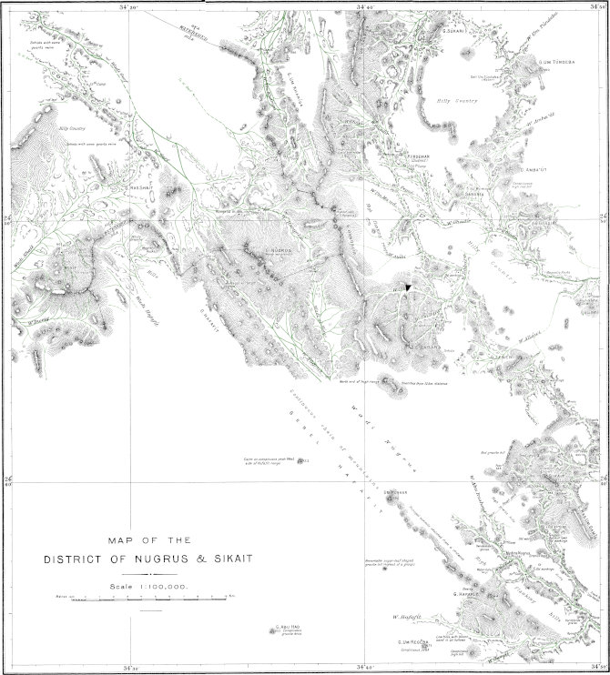
MAP OF THE DISTRICT OF NUGRUS & SIKAIT Ball. Geography & Geology of South-Eastern Egypt. PLATE VI. Photo-Metal-Process. Survey Dept. Cairo 1910. (60-190)
Wadi Abu Ghusun commences its course among the high mountains of Gebel Abu Ghusun, north of Gebel Hamata. Pursuing a northerly course for about ten kilometres, it passes close east of the sharp granite peak of Gebel Hefeiri, then turns more to the east, receiving Wadi Romit as an important tributary from the west near the bend, and reaches the sea in about latitude 24° 29′.
Wadi Romit, a tributary of Abu Ghusun, originates in the granite mountains called Gebel el Abiad, near the parallel of 24° 20′ and follows a winding course in a general easterly direction for about sixteen kilometres to its junction with Wadi Abu Ghusun. It receives several important tributaries. The chief of these, Wadi Shoab, originates close to the south-west of Gebel Shoab, where there is an easy pass into the Wadi el Abiad. Another tributary of Romit, the Wadi Abu Hegilig, drains the south part of Gebel Um el Abbas, while a third is the Wadi Hefeiri, draining the hills round the granite peak of the same name. All these tributaries, like Wadi Romit and Wadi Abu Ghusun itself, contain abundance of trees, and have a rather rapid fall.
Wadi Hamata drains the eastern flanks of the high hills north of Gebel Hamata, its principal heads being about latitude 24° 15′. Only the heads of this wadi have been surveyed; it follows a winding course among the lower hill country and reaches the sea in about latitude 24° 24′.
Of the three wadis draining seawards south of Hamata, called Wadi Haratreit, Wadi Khashir, and Wadi Mikbi, very little is known, not even their heads having been visible from the stations which I occupied. The summits of the mountains drained by them have, however, been mapped, and their courses are approximately known from the accounts of Floyer; these are indicated on the map probably in nearly their true positions. Draining mostly steep and precipitous mountain faces, the upper parts of these wadis must have an extremely rapid fall, and consequently a rough stony floor.
Wadi Lahami, which enters the sea north of the peninsula of Ras Benas, is well known by reason of the easy pass over the main watershed at its head forming an important means of access to Berenice from the west. At this point, four kilometres north-east of the white quartz cone called Marwot Elemikan, the watershed is sandy, level, and low, being only 590 metres above the sea. The drop on crossing the watershed is fairly rapid, the wadi winding about among the hills in a general north-easterly direction. About six kilometres below its head, Lahami receives the Wadi Um Karaba, which drains the south face of Gebel Abu Gurdi. A little further on, Wadi Eidab enters from the south-east; this feeder is said to head in a rough steep pass over the hills into the Wadi Abu Daba. After passing between the high hills of Gebels Um Goradi and Um Gunud, Wadi Lahami receives the short Wadi Um Gunud, in which there are two well known galts, or rock basins forming reservoirs of rain water; these contained good supplies in 1906-7. Lower down, Wadi Lahami crosses a stony sloping plain, where it receives the drainage from the north and east flanks of Gebel Abu Gurdi and from the mountains to the north of it, by a series of feeders, the principal of which are Wadi Um Rishan, Wadi Um Homar, and Wadi Sefent. East of the plain there is a sort of shunt or loop-line of Wadi Lahami, called the Wadi Abreik, which is preferred to the main channel for a road. Just receiving Wadi Sefent, Wadi Lahami turns sharply eastward, and then north-eastward, receiving as feeders Wadis Um Khuzama, Um Ghobasha, and Gumudlum, draining Gebels Um Sellim and Gumudlum to the north; these feeders are said to contain natural reservoirs full of water after rain. From the south, Lahami is fed by the Wadis Um Eshub and Abu Marwa lil Lahami, draining the lower hill country. The lower course of Wadi Lahami has not been traced in detail. It passes north-west of the well marked granite peak called Gebel Um Huk, as remarked above, and reaches the sea north of the peninsula of Ras Benas. To get to Berenice, one leaves Wadi Lahami about twenty-four kilometres below the pass at its head, and turns off south-east up the tributary Wadi Abu Marwa, which leads to Wadi Naait by an easy road.
Wadi Lahami is well supplied with trees; it presented a very green appearance early in 1906, but the absence of rain for a year made it much more desolate looking in 1907, all the foliage being then blackened and withered. Its length is approximately fifty kilometres, its average slope twelve metres per kilometre, and the area of its basin is about 650 square kilometres.
The drainage from the low hills on the Peninsula of Ras Benas, except for a small portion which joins Wadi Mukhit, reaches the sea by a multitude of small wadis, none of which bear special names. The hills being nearer to the south side of the peninsula than to the north, the wadis draining southwards are on the whole much shorter and steeper than those draining northwards, and the latter cross a sloping plain two or three kilometres wide to reach the sea. Passage across the hills from south to north is only possible to camels at a few places. The southern wadis are mostly barren, but the northern ones contain abundance of a dark coloured grass of which camels are fond. There is no permanent water source on the peninsula, the nearest reliable source of supply being a galt in Wadi Mindeit, on the main land, about twelve kilometres west of Berenice. The tip of the low sandy projection of Ras Benas is marked by a sheikh’s tomb, one of the largest on the coast. It is chiefly built of wreckage cast up on the beach. From the hills it looks like a rectangular rock, and I determined its position by triangulation as latitude 23° 53′ 50″ N., longitude 35° 47′ 13″ E. The sheikh’s memory appears to be greatly venerated by sailors, and several of my camel men made pilgrimages to the tomb to pray.
The Island of Mukawar, about six kilometres south of the sandy tip of the ras, is nearly two kilometres in length from north to south. I did not visit it, but it has the appearance of being made of coral; its highest point, near the south end, is thirty-four metres above the sea-level.
Wadi Abu Daba drains the eastern flanks of Gebel Eidab and Gebel Um Maiat, and courses eastward through the lower hill country to the coast plain, where it joins the drainage from Naait in Wadi Mukhit. The principal feeder of Abu Daba is Wadi Murra which enters it from the south-west a few kilometres before its emergence on to the plain. At the head of Wadi Abu Daba there is said to be a rough steep pass over the mountains into Wadi Eidab. The place where Abu Daba debouches on to the coast plain is marked by a group of low bouldery looking granite hills called Khasheib Abu Daba.
Wadi Abu Dibban is a short wadi draining eastwards from the hills across the coast plain to the sea a little north of Berenice. In its course across the plain it passes a little north of a conspicuous granite hill called Sikeit, a well known landmark five kilometres north-west of Berenice.
Wadi Mindeit drains the hills between Gebel Um Maiat and Gebel Kalalat, entering the sea at Berenice.[91] Wadi Um Sellim lil Mindeit, a shorter wadi coursing across the plain a little further south, is interesting as furnishing the nearest fresh water source to Berenice; it leads to a rock basin or galt among the hills, where rain water collects. This source is some ten or twelve kilometres from Berenice.
Wadi Naait[92] is a narrow tortuous gorge, with a sandy floor shut in by high hills, coursing eastward to the coast plain a little south of the 24th parallel. Though only a small wadi some sixteen kilometres in length, it is well known because it forms the usual road from Wadi Lahami to Berenice. Its actual head has not been surveyed, but lies probably between the mountains of Um Gunud and Um Hegilig. Its principal feeders are Wadis Um Sumer and Abu Marwa lil Naait, which enter it from the north-west, and Wadi Abu Ghalqa, entering from the north and draining the granite hills called Gebel Abu Ghalqa. All three of these feeders enter Naait near together, some ten kilometres before it emerges on the plain; the lower part of the wadi is free from lateral branches. The fall is ten metres per kilometre among the hills. On emerging from the hills on to the sandy coast plain, it joins an ill-defined drainage line called Wadi el Mukhit, which enters the sea at Port Berenice, some fifteen kilometres further east. The name Wadi el Mukhit is also given to other ill-marked drainage lines entering Port Berenice from the sandy tract between the hills of the main land and the hills of the peninsula of Ras Benas. Some three kilometres north-east of the mouth of Wadi Naait, on the coast plain, is a conspicuous isolated low hill, forming a well-known landmark and called Grain el Rih. The plain drained by Wadi el Mukhit is a dreary sandy waste, and the crossing of it in a high wind is very trying by reason of the immense clouds of sand raised and carried in the air.
Wadi Kalalat heads in the north-west portion of Gebel Kalalat, and courses nearly eastward to reach the sea in latitude 23° 52′. For the first two-thirds of its course of about thirty kilometres, Wadi Kalalat is shut in by high hills, and falls rather rapidly. At its head a rough steep pass is said to exist into the head of Wadi Shut. After passing round the north flank of Gebel Kalalat, the wadi receives two small tributaries called Wadi Um Maiat and Wadi el Dibag lil Batoga, the former draining the north-east face of Gebel Kalalat and the latter the north-west face of Gebel Batoga. After receiving Wadi Dibag, the Wadi Kalalat makes a bend northward for about two kilometres, then turns south-eastward to the opening of the hills on the coast-plain. About two kilometres above the point where it leaves the hills, on the south side of the main wadi, is a rocky gully containing the Galt Batoga a rock basin which contained good water in 1907 and which is very easy of access in a few minutes from the main wadi. About one and a half kilometres further down, the small Wadi Um Sellim, draining the north-east parts of Gebel Batoga, joins the Wadi Kalalat just before it opens on to the coast-plain. The course of Wadi Kalalat from here to the sea, about eleven kilometres, is ill-marked, over a sandy plain. A ruined enclosure of considerable size, called Garia Kalalat, lies close south of the wadi about seven kilometres from the sea.
Wadi Um Goran is a small wadi draining by many heads from the east face of Gebel Batoga and its foot hills to the sea in latitude 23° 50′.
Wadi Kunserob, draining the south parts of Gebels Kalalat and Batoga, courses at first nearly southwards, then curves round south of Gebel Dibag, and after receiving Wadi Dibag lil Kunserob from the north-west, proceeds eastward through the hills and across six kilometres of sandy coast-plain to the sea in latitude 23° 47′.
Wadi Abu Berigâ is a short drainage line from among the hills to the sea, a little south of Wadi Kunserob.
Wadi Khoda is an important main drainage channel some forty-five kilometres in length, coursing a little north of eastward to reach the sea in latitude 23° 43′. For the greater part of its length it is shut in by high hills, only the last six kilometres being across the sandy coast-plain. With a basin approximately 780 square kilometres in area, it drains the mountains of Abu Dahr, Dahanib, Shut, Reyan, Shenshef, Hindia, and Um Akra, some of which rise to over 1,000 metres above the sea; it thus receives a fair amount of water in rainy years, and is well supplied with trees and bushes. Its average fall is about nine metres per kilometre.
The head of Wadi Khoda is formed by the union of three wadis, coming approximately from the north, west, and south, in the form of a cross. The central one of these, Wadi Abu Debebi lil Khoda, heads in a very easy pass leading to Bir Betan and the old mines of Um Eleiga. The one to the north, Wadi Salib el Abiad, is said to lead into Wadi Khiua, and to possess some old mines, but has not been explored. The remaining one of the three, Wadi Salib el Azrak, drains the east face of Gebel Abu Dahr and the high hills east of it; the feeder of it from Abu Dahr, called Wadi Um Karaba, leads by an easy pass, just north of the mountain, to Bir Betan and the Um Eleiga mines, while some eight kilometres from its junction with Khoda a track leads up a gully south-westward over another easy pass to Bir Rahaba. The names Salib el Abiad and Salib el Azrak refer to the form of the wadis and the nature of their floor, salib meaning “cross,” while abiad and azrak refer to the prevailing white and dark colours of the sand in the respective arms of the cross; these colours are due to the wadis draining light-coloured granites and dark-coloured serpentines and schists respectively.
A little below the union of the three arms above-mentioned, Wadi Khoda expands into a small rather stony plain, where the sinuous Wadi Allawi[93] enters from the north. This important feeder, which drains the eastern face of Gebel Dahanib, is mostly shut in by high hills, and is relatively well wooded; if it be followed up for about ten kilometres, one comes to the tomb of Sheikh Farhan, near which meet many small feeders, one of them containing a small rock basin near its head.
About eight kilometres below the point of entry of Wadi Allawi, Wadi Khoda receives two feeders from opposite sides; that from the north, Wadi Um Tawil lil Khoda, drains from Gebel Dahanib, while that from the south, Wadi Hindia, is a sandy rapidly-falling wadi draining Gebel Hindia.
Some five kilometres further down, Wadi Um Akra, draining the mountains of the same name, enters Khoda from the south, while another two kilometres brings us to the place of influx of Wadi Shut, an important feeder from the north. The head of Wadi Shut is on the west side of Gebel Kalalat, whence its course is westward for about ten kilometres; it is then joined by the Wadi Abu Hugban, coming from the south-west, and from this point it runs south-south-east for some twenty-three kilometres to its junction with Wadi Khoda. Wadi Shut is a rather wide wadi with a sandy floor, fed by many tributaries from the mountains of Dahanib, Um Hegilig, Reyan, and Shut. Its principal feeder in the lower part of its course is Wadi Um Tawil lil Shut, which drains the south part of Gebel Dahanib and enters Shut from the west about five kilometres above its junction with Khoda. The Wadi Shut has a fair growth of trees, and is said to possess also a large water source, the exact locality of which has not, however, been ascertained.[94]
Just below the place where Wadi Shut joins it, Wadi Khoda receives a small feeder called Wadi Um Gubur, entering from the north and marked by several graves near its mouth. On the other side, two kilometres further on, Wadi Shib enters from the south, and five kilometres further the Wadi Um Seyal lil Khoda enters Khoda from the north.
The Wadi Gumudlum, the next great feeder of Khoda, enters from the north four kilometres below Wadi Um Seyal. It is a wadi some eighteen kilometres in length, coursing south-south-east, and having its head on the west side of Gebel Kalalat. A little below wadi Gumudlum, near a boss of white quartz, several small feeders, of which the two principal are called Wadi Buluk and Wadi Um Lassaf, enter Wadi Khoda from the south; these drain the north side of the high hills called Gebel Um Etli.
The last feeder of Wadi Khoda, the Wadi Shenshef, enters the main wadi some three kilometres above the place where it debouches on to the coast-plain, or eight kilometres from the coast. It is a narrow and very tortuous gorge winding among high hills. If it be followed up for about ten kilometres, one comes to several small wells called Bir Shenshef, which contained water in 1907, and a little above the wells, where the wadi becomes more open, there are ruins, called Hitan Shenshef, which attest the former existence of a town or large village. The ruins are on both sides of the wadi, and many of them are extremely well built of slabs of quartz schist; besides the houses in the wadi itself, there are small towers on the hills. As there are apparently no mines in the hills here, the origin of the ruins is not clear; from the strong situation and the watch towers, and its proximity to fresh water and the sea, it may possibly represent an old slave dealer’s stronghold.
For some eighteen kilometres south of the Wadi Khoda, the seaward drainages have not been explored, but they are believed to be only short wadis, as the high mountains of Faraid are here only about ten kilometres from the coast. From guides’ statements, the Wadi Um Etli, coursing eastward and draining the south faces of Gebel Um Etli, enters the sea in about latitude 23° 38′, and there is probably at least one other short wadi draining to the sea about in latitude 23° 35′ from the north part of Gebel Faraid. The sandy coast-plain in this region is about five kilometres wide.
The Wadi el Sorubiab, draining from the north part of Gebel Faraid, and the Wadi Bint el Kurdum, draining the mountains around the remarkable “Bodkin” peak, enter the sea together by way of a small lagoon in latitude 23° 30′. Another wadi, for which I could not obtain any name from my guides, drains the extreme south parts of Gebel Faraid and the north slopes of the smaller Gebel Fereyid, entering the sea in about latitude 23° 19′.
Wadi Rahaba, with a basin of about 900 square kilometres in area, drains the country between Gebels Faraid and Abu Dahr. From its head, situated about six kilometres south-east of Gebel Abu Dahr, there is an easy pass into Wadi Salib el Azrak, a tributary of Wadi Khoda. About three kilometres below its head, a feeder called Wadi Titai enters Rahaba from the hill country to the east; and a kilometre lower down, another feeder called Wadi Abu Nikheil, comes in from the west. At this point there is an important well, Bir Rahaba, sunk in the alluvium of the wadi floor; this is said to yield good summer supplies, but was filled up by downwash when I visited it early in 1907. Some three kilometres below Bir Rahaba, a tributary called Wadi Abu Reye enters Wadi Rahaba from the north-west; and there is said to be a well, called Bir Abu Reye, about one and a half kilometres up this wadi. Another feeder, the Wadi Um Buerat, joins Rahaba from the south-west a little further on, and then the wadi, which has thus far taken a southerly course, turns south-east, winding considerably for some eight kilometres till it is joined by its most important feeder, the Wadi el Abiad.
This Wadi el Abiad drains the western side of the northern peaks of Gebel Faraid, and derives its name from the white granitic sand which forms its floor. It has a length of some twenty kilometres and is fed by the Rod Elbel, which heads in a sandy plain at the foot of the highest peak of Faraid, and by the Wadi Abu Ribian, which collects the drainage from the lower hill country west of the Bodkin peak.
About three kilometres lower down than the point of influx of Wadi el Abiad, Wadi Rahaba receives the Wadi Megah as a tributary from the north-west; a well, called Bir el Gahlia is said to exist at the head of this wadi, about twelve kilometres up from its opening into Wadi Rahaba. Some six kilometres further down, Wadi Rahaba opens out; its course down to this point has been shut in by high hills, but now becomes an ill-marked drainage line over a sandy plain. The plain is broken by small hills, and is limited east and west by other hills which increase in height further away, forming in fact the foot-hills of Gebels Orga and Um Tenebda on the west and of Gebel Faraid on the east. In this part of its course Rahaba receives several tributaries, the principal being Wadi Hutit from the north-west, Wadi Dagalai lil Rahaba and Wadi Abu Had from the east, and Wadi el Marafai, which runs for some ten kilometres nearly parallel to Wadi Rahaba, among low hills two or three kilometres east of the main Wadi, joining the latter about due west of Gebel Fereyid.
Wadi Rahaba curves round to the south of Gebel Fereyid in a quadrant of about seven kilometres radius, and then proceeds nearly due east to reach the sea in about latitude 23° 12′.
The upper parts of Wadi Rahaba, where it is shut in by high hills, contain many trees and bushes; but the lower parts are more barren and sandy, the actual drainage line being in places difficult to define on account of the paucity of vegetation and the openness of the plain. The total length is about seventy-five kilometres, and the total fall 450 metres; the slope averages eight metres per kilometre in the upper twenty-five kilometres, where the wadi is narrow and shut in, but only five metres per kilometre in the broad and sandy course which forms the remaining fifty kilometres.
Wadi Hodein, one of the largest and most important of the seawards draining wadis of the Eastern Desert, has a basin of nearly 12,000 square kilometres, or over a square degree of the earth’s surface. Its main channel, formed by the union of the Wadis Arned, el Sania, Um Sumur, Saalek, Um Reit, and el Nom, in latitude 23° 18′, longitude 34° 43′, and reaching the sea at Bir Shalatein[95] in latitude 23° 8′, longitude 35° 37′, has a length of 108 kilometres and an average slope of three metres per kilometre. For the first fifteen kilometres of its course it is shut in by the high sandstone scarps of Gebel Abraq and Gebel Hodein; but shortly after passing the Abu Saafa Springs its channel becomes wide and sandy, passing through lower metamorphic hill country; and in the last twenty-five or thirty kilometres of its course it is merely an ill-defined drainage line over the sandy coast-plain. Its lower reaches are dreary and inhospitable, but its upper-portion is pleasantly wooded, and contains the perennial springs of Abu Saafa. Wadi Hodein is remarkable for the large number and length of its tributary wadis, some of which exceed the main channel itself in length, while many of them contain wells and form important lines of communication by leading to easy passes over the main watershed. In the description which follows, I shall first consider the wadis which by their union form the head of the main channel, afterwards tracing the course of the main wadi in detail to the sea, noting the influx of the various tributaries on either hand, and finally describing the larger tributaries themselves.
The most important of the wadis which join to form the head of Wadi Hodein are Wadis Arned, Saalek, and Um Reit. These join in a small plain with the Wadis el Sania, Um Sumur and El Nom, which are smaller and will not need further mention.
Wadi el Arned originates on the main watershed about five kilometres south-east of Galt el Aguz. The watershed here is only 427 metres above sea-level, and is so flat and sandy that it is almost impossible to say within a kilometre where the divide actually is; the wadi in fact heads in a sandy plain about two kilometres wide with low sandstone hills on either hand, from which feeders join the main drainage line. About six kilometres below its head, Wadi Arned is joined from the south by its most important feeder, the Wadi Muegil. This wadi, which has a length of some twenty kilometres, originates in the hill country about nine kilometres north of Gebel Um Reit, where an easy pass connects it with Wadi Saalek; it flows in a northerly direction, entirely among sandstone hills, and is fairly provided with vegetation. Some two kilometres lower down, Arned receives a smaller feeder from the north, called Wadi Um Arta; by following this up for about five kilometres, one can reach a rather steep and sandy eastward pass into the head of Wadi Silsila, and this forms the shortest route from the Galt el Aguz to the springs of Abraq. About four kilometres below the junction of Wadi Abu Arta, near an isolated hill on the east side of the Wadi Arned, there appears to be another opening into one of the heads of Wadi Silsila; this opening is very sandy and looks like a practicable alternative route to Abraq Springs, though it has not been explored. Lower down its course, Wadi Arned is at first very sandy and bare, with high sand-drifts swathing the feet of the hills on the east; but it gradually narrows into a gorge and becomes less sandy, then opens out again, and near its junction with Wadi Hodein it contains abundant vegetation. The Wadi Arned forms the easiest and most direct road from Abu Saafa to Daraw, via Galt el Aguz, Bir Abu Hashim, and Bir Qoleib.
Wadi Saalek is a short wadi with many feeders, draining the hills round Gebel Saalek; one of its northern feeders leads to a pass into the head of Wadi Muegil, while one of its south branches heads in a pass leading round the west side of Gebel Um Reit to Wadi and Bir Um Reit.
Wadi Um Reit heads in the granite mountain called Gebel Um Reit and flows north-eastward, to the south of the mountain, for about twenty-two kilometres, to its junction with Arned and Saalek to form Wadi Hodein. The head of Wadi Um Reit leads to a pass north-west of the mountain into Wadi Saalek, while the western head of Um Reit, which bears the name Wadi el Dub, leads on to a sandy plain forming the main watershed, whence there are easy tracks to the various feeders of Wadi Timsah. The well called Bir Um Reit is a deep excavation, in the wadi floor at the foot of the mountain, near a large tree. Dr. Hume, who visited it in 1906, found it to yield water of only mediocre character. It is about one hundred kilometres by road from Bir Abu Hashim, the nearest well to the west, but only about thirty kilometres from Abu Saafa Springs, the nearest water eastward; to get to Abu Saafa from Bir Um Reit, one has only to follow down the wadi, and the supply at Abu Saafa can always be relied on for quantity and quality. Near the well, Wadi Um Reit receives feeders draining the high granite hills of Etresia; the principal of these is called Wadi Malhat. The lower part of the course of Um Reit is almost entirely in sandstone hills; it has not been mapped in detail except near its junction with Hodein.
We turn now to the main channel of Wadi Hodein, which originates, as above-mentioned, by the union of the Wadis Um Reit, Saalek, Arned, and other smaller wadis in a small plain, and shall follow its course onwards to the sea. Three small feeders, Talet Um Danaqa and Talet Kurit on the south, and Talet Um Sideri on the north, join the channel a few kilometres below its head, while about nine kilometres from the head there enters a larger wadi coming from the south, called the Wadi el Gihab. The main Wadi Gihab has not been followed, but its eastern branch, called Wadi Gihab Abu Derb, contains a large and very easily accessible galt about four kilometres from Hodein, and leads about ten kilometres further on, to a very steep and difficult pass into Wadi Dif; this pass is practicable only on foot, being risky even for unladen camels.
The Springs of Abu Saafa are situated in the Wadi Hodein, about two kilometres below the point of influx of Wadi Gihab, at an altitude of 310 metres above sea-level. The Wadi Hodein is here narrow, and shut in by very high steep sandstone scarps. There are four springs, all issuing from the northern scarp at intervals of about sixty metres along the wadi, and all about three metres above the wadi floor, trickling into pools about a metre in diameter close by. The most westerly of the four springs is a mere trickle; the next yields a rather greater flow, from a carved niche in the rock, with a Greek cornice; the third is the one most used, having the greatest flow of the four, while the easternmost is almost stagnant and has yellow incrustations near it. The rate of flow, even from the largest spring, is very slow, probably not more than ten litres per minute, and the overflow from the pools is only a tiny stream a few centimetres wide which soon loses itself in the sand of the wadi floor; but the pools are large enough for a dozen or more camels to drink from, and soon fill up again when emptied. The water is of excellent quality, very clear, and the supply never fails. Near the springs there are five or six small date palms, and the wadi hereabouts has many other trees. After rain, this part of Wadi Hodein at times becomes a stream; this was the case in October 1907, for I found numerous pools in the wadi floor, and scum and froth showing that an impetuous stream about half a metre deep had flowed down the wadi only a few days prior to my visit. Just below Abu Saafa Springs, Wadi Hodein receives the short Wadi Maghal from the north-west; this wadi, which is walled in by high sandstone plateaux, contains water holes about three kilometres from Wadi Hodein; but these are less important than the springs of Abu Saafa, and are, moreover, off the main road.
Wadi Hodein now opens out, the high sandstone scarps of Gebels Abraq and Hodein running north and south-east, and enters a sandy plain with very low hills, from among which some small feeders join the main wadi. About fifteen kilometres below the opening of scarps, Wadi Hodein receives, from the north-west, the Wadi Naam,[96] a great tributary draining the mountains of Zergat Naam, Um Bisilla, and Abu Dahr. The next influx is from Wadi Dif, which enters Wadi Hodein from the south-west about six kilometres further on; Wadi Dif itself is only a short wadi, but it collects the drainage of an immense area to the south by long feeders, and contains a good well. Nearly opposite to Wadi Dif, the Wadi Orga el Atshani joins Wadi Hodein from the north-west; the Wadi Hodein has here two large island-like masses of low hills in it, between which the main drainage line passes. Lower down, Wadi Orga el Rayani enters by two mouths from the north. Both the Wadis Orga are said to originate near Gebel Orga, some thirty kilometres to the north, but their courses have not been mapped; the one called El Rayani is said to lead to a good well, Bir Orga, about twelve or fourteen kilometres above its junction with Hodein. On the opposite (south) side, Wadi Hodein receives the Wadi Anfeib, draining the high sandstone plateau of Gebel Anfeib. A little further on the small Wadi el Khasiya comes in from the north, by two channels, one on either side of a small group of isolated hills; and nearly opposite is the mouth of Wadi Madi, which drains the west side of the great mountain mass of Gerf, some sixty kilometres to the south, and possesses a good well about fifty kilometres up its course from Wadi Hodein. Several feeders come in from the north a little further down the wadi, of which the chief is the Wadi Um Tenedba, draining the mountain of the same name, while others drain the hill country round Gebel Harhagit. On the other (south) side is the mouth of Wadi Khashab, draining the west side of Gebel Khashab and the hills west of it. A few kilometres further on, Wadi Hodein widens considerably, and from here onward it is very sandy and arid. A long spur running north-west from Gebel el Anbat nearly cuts across the wadi, the main channel of which passes north and east of the spur, while to the west of it is a rather broad sandy plain with ill-marked drainage lines from the hills, of which the chief bears the name of Wadi Um Seleim. Near Gebel el Anbat are numerous small feeders of Wadi Hodein from that hill and the other hills to the north-east. About eight kilometres below Gebel el Anbat, Wadi Hodein quits the hills and, turning a little north of east, merges into the coast-plain, over which its remaining course of about twenty-seven kilometres is very ill-defined. Just where it leaves the hills, Wadi Hodein is joined from the south-west by Wadi Beida, draining the mountain of the same name and containing two wells; and a little further on it receives Wadi el Kreiga, which drains the hill country round Bir Meneiga. The junctions of Wadi Beida and Wadi Kreiga with Wadi Hodein are very difficult to trace on the ground, being almost lost in the general sandy plain.
Bir Shalatein, a very salt well in the Wadi Hodein, about two kilometres from its mouth and only about seven metres above the sea, is chiefly of importance by reason of its marking the administrative limit of the Egyptian and Sudan spheres of government. It is merely a few shallow pits sunk in the wadi bed, yielding water drinkable only by camels. An iron beacon two metres high has been erected on a low bank close to the well, and will enable the well, which is itself inconspicuous, to be easily found.
Wadi Naam, a great tributary of Wadi Hodein coming from the north-north-west, originates about ten kilometres south-east of Gebel Zergat Naam by the union of the Wadis Abu Seyal, El Fil, and Um Bisilla, and courses south-south-east for about forty-nine kilometres to its junction with Wadi Hodein. It is a very barren wadi, being for most of its length a broad, shallow, and very sandy drainage line among low hills, and in its lower parts, where it crosses the plain of Abraq, its course is very ill-marked. Its slope decreases from five metres per kilometre near its head to about three metres per kilometre in its lower reaches. Besides the three wadis which, as above-mentioned, unite to form its head, Wadi Naam has several large tributaries, of which the chief are the Wadis Silsila and Abraq on the west, and Wadis Erf Um Araka, Arais, and Betan on the east.
The Wadi el Fil, which may be regarded as the main head of Wadi Naam, though it is not the longest, drains the north-east portion of Gebel Zergat Naam (sometimes called Hagar el Fil). The rocky gullies forming its heads contain rock basins which yield water for a short time after rain.
Wadi Abu Seyal drains the south part of the same range; its head is very steep, and is said to contain a very large galt, which holds supplies of water for five months after rain.
Wadi Um Bisilla drains Gebel Um Bisilla, which it half encircles, its main head being north-east of the mountain, where there is an easy pass into Wadi Abu Nilih, and thence an easy road to the head of Wadi Lahami. About eleven kilometres west of the mountain, Wadi Um Bisilla receives, from the north-east, the Wadi el Khiua, which, with its tributaries, Wadis Abu Fagir and Abu Nilih, drains the low hill country north of Gebel Um Bisilla. The lower parts of Wadis Um Bisilla and Khiua have not been surveyed in detail; their courses as shown on the map are only approximate, but being based on guides’ statements near the spot they are probably substantially correct.
Wadi Erf Um Araka heads as a series of small wadis among the low hills south of Um Bisilla, and curves round westward between the high hills of Abu Shigelat and Erf el Gimal on the north, and Erf Um Araka or Gebel Belamhandeit on the south, to join Wadi Naam about five kilometres lower down than Wadi Um Bisilla. The hill country round the heads of Wadi Erf Um Araka is fairly open, so that one can proceed freely from the head of Wadi Arais, across those of Wadi Erf Um Araka, and on into the heads of Wadi Um Bisilla.
Wadi Arais originates by the union of many small feeders in the low hill country between Gebels Um Guruf and Hendusi, and courses for the first fourteen kilometres in a south-south-west direction. About nine kilometres below its head the Wadi Um Guruf, draining the hills round the conspicuous granite boss called Gebel Um Guruf, enters from the north-west. Some five kilometres further on, just beyond the place where Arais makes a sharp westward bend, Wadi Belamhandeit, draining the east face of the long gneiss range called Erf Um Araka or Gebel Belamhandeit, enters from the north. Wadi Arais now narrows into a winding gorge, cutting westward for about ten kilometres through the complex of high gneiss hills called Gebel Arais to join Wadi Naam. Its junction with Wadi Naam takes place in a small plain, with the sandstone plateaux of Gebel Um Sididad on the west and the gneiss hills of Gebel Arais on the east. The fall of Wadi Arais is from 464 metres above sea at the pass into Wadi Erf Um Araka, to 345 metres where it joins Wadi Naam after a course of twenty-five kilometres; so that its slope averages four and a half metres per kilometre.
Wadi Silsila[97] heads in high sandstone hills on the meridian of 34° 40′, north of Gebel Abraq, where at least one pass, steep and sandy, leads to the Wadi Arned. Its course is almost due east, over a plain with low sandstone banks, with a great deal of blown sand. Feeders enter it from the sandstone hills which bound the plain, the principal being the Wadi Um Sididad, draining the high sandstone hills, called Gebel Um Sididad, on the north. About seven kilometres before it joins Naam, Wadi Silsila cuts through the range of low sandstone hills which stretches southward from Gebel Um Sididad to near Abraq springs; in proceeding to Abraq from the pass at the head of Wadi Silsila, one bears off to the south before reaching this range, entering the drainage of Wadi Abraq over an open sandy plain.
Wadi Abraq is a rather ill-defined drainage line which originates on the north side of Gebel Abraq, and after skirting the high sandstone scarp, from which it receives small feeders, for about thirteen kilometres, turns eastward to join Wadi Naam, about nine kilometres above its junction with Hodein. Wadi Abraq is sandy and barren, and would be scarcely worthy of mention but for the fact that it contains some of the most important water sources of the entire Eastern Desert, the Abraq Springs. There are no less than five springs within a length of as many kilometres of the wadi, yielding perennial supplies of excellent water.
The first spring from the north, called Bir el Sunta, is a pool about two metres in diameter at the entrance to a little gully in the face of the high sandstone scarp; it is very easily accessible to camels, being practically on the plain, and fills as rapidly as it is emptied. The second and third springs, called together Bir Abu Dibesat, are about 1,500 metres south-east of Bir el Sunta, near the tomb of Sheikh Hamid; they form smaller pools at the foot of the scarp. The fourth spring, Bir Abraq, is situated a short distance up a stony gully which emerges from the scarp a little further south; the water lies in large pools under dipping sandstone beds on the south side of the gully. The fifth spring, Bir Gumbit, is said to be some three kilometres further south-east, and, like the others, at the foot of the sandstone scarp; it has not, however, been visited by the survey party.
Fig. 2.—Map of Abraq Springs. Scale: 5 centimetres to a kilometre.
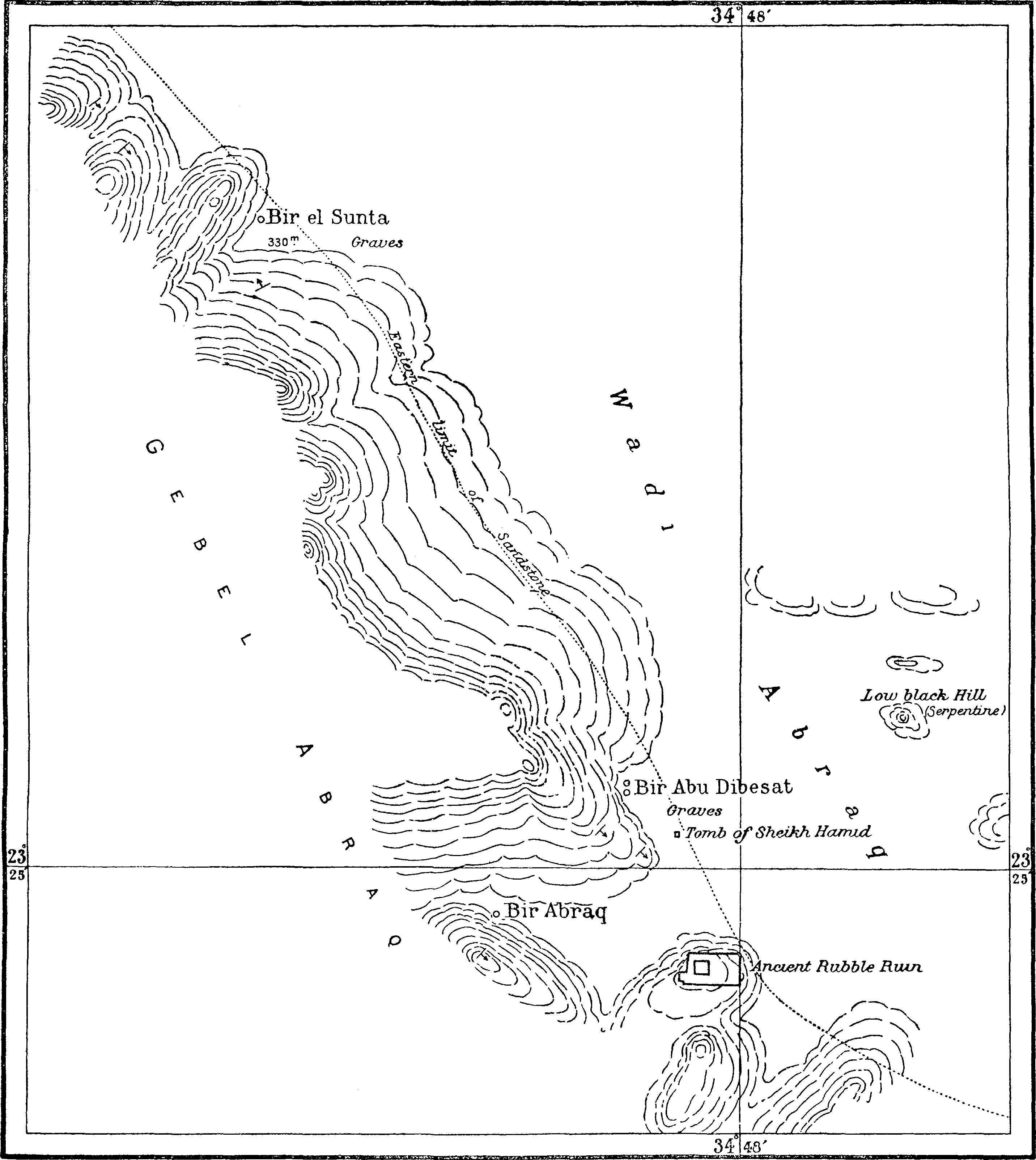
The water at all the Abraq Springs is of excellent quality; it contains masses of green algæ, but these are easily avoided in baling out, and the water can be obtained quite clear. Of the four springs visited, the one called Bir Abraq is the chief; but Bir el Sunta is rather easier of access for camels. The springs are practically all at the same level, viz., 330 metres above sea, and all derive their water from the same sandstone beds. No camel food grows near the wells, and there are very few trees in the vicinity; consequently, the Arabs of the neighbourhood do not camp near the springs, but in Wadi Hodein and its tributaries, drawing water from Abraq or Abu Saafa at intervals. There are, however, ruins of a large ancient fort on a low hill east of Bir Abraq, and some Arab graves a little further north; among these latter is a large tomb said to be that of Sheikh Hamid.
Wadi Betan originates on the north side of Gebel Abu Dahr, where an easy pass, 610 metres above sea-level, connects its head with Wadi Um Karaba, and courses at first westward to near Gebel Hendusi; it then turns southward to join Wadi Naam a few kilometres only above its junction with Wadi Hodein. Its total length is over fifty kilometres, and its average slope is about seven metres per kilometre. Only the head of Wadi Betan has been surveyed in detail; but this is the most important part, as containing water sources and old mine workings; and the lower part of its course as shown on the map is probably substantially correct, being based on statements made near the spot by guides familiar with the district.
About five kilometres below its head, Wadi Betan contains the two wells called Bir Betan. These are excavations in the alluvium of the wadi. The lower one is at the mouth of the small Wadi Um Eleiga, while the other is about 600 metres further up Wadi Betan, close to a small tree. Both these wells were filled up by downwash when I visited them in February 1907, and their places were only recognisable by the clay “hôds” near them; at this time there was no necessity for the Arabs to open them, as a galt at the head of the wadi, just south of the pass into Wadi Um Karaba, was yielding a good supply of water.
Just above the wells, Betan receives from the south the feeder called Wadi Mistura, draining the west side of Gebel Abu Dahr. The little Wadi Um Eleiga, which drains into Betan close to the south well, is of importance as leading to some extensive ruins and old workings about two kilometres up from its mouth. The ruins are mostly rubble hovels, while the workings, which were evidently for gold, vary from mere scratchings to pits ten metres deep in the rock. A diorite mill-stone is to be seen near the ruins.
The Wadi Abu Debebi lil Betan, which joins Betan on the north about three kilometres below the wells, leads by an easy pass into Wadi Abu Debebi lil Khoda, one of the heads of Wadi Khoda, and forms the nearest way to the coast from Bir Betan. Wadi Abu Sieiyil is a small feeder entering Betan from the south, three kilometres further down. The principal remaining tributaries of Betan are the Wadis Hefeiri, Abu Beid, and Egat. Wadi Hefeiri runs westward from near the Abu Debebi pass, and turning south near Gebel Hendusi, receives the Rod el Hendusi just before entering Betan. Wadi Abu Beid el Azrak originates near Gebel Abu Sieiyil west of Abu Dahr, and flows southwards to join Wadi Abu Beid el Abiad, which in turn flows into Wadi Betan. A well, Bir Abu Beid, is situated near the junction of Wadi Abu Beid el Abiad and Wadi Abu Beid el Azrak, where there are numerous seyal trees; it was yielding a fair quantity of good water in 1906. Of the Wadi Egat, nothing has been seen; it is, however, stated by the Arabs to originate in the rugged hilly tract south of Gebel Abu Dahr, and to join Wadi Betan lower down its course than Abu Beid.
Wadi Dif originates in the sandstone hills round Bir Dif, and pursues a very sinuous north-easterly course, cutting through the high sandstone plateau which is named Gebel Hodein to the north, and Gebel Dif to the south of it. For the major part of its length of twenty-nine kilometres it is very narrow, with very high steep sandstone scarps on either side, but it is a little more open near its origin, where Wadi Feqoh joins it, and in its lower part it winds as a broad sandy valley through the low hills which separate the Wadi Hodein from the high sandstone plateaux; it joins Wadi Hodein close to the meridian of 35°. Except the Wadi Feqoh, which is of immense length, and drains a very large area, Wadi Dif has only a few insignificant feeders. Of these, Talet Um Karaba and Wadi Enqireidia enter from the south plateau near the place where Wadi Dif leaves the high sandstone hills; and Wadi Gelabat Shabai, coursing north-east through the low hill country flanking the plateau, joins Wadi Dif just above its junction with Hodein.
Bir Dif is situated in a small gully forming the head of Wadi Dif, in latitude 23° 12′ 42″. To a traveller coming up Wadi Dif, Wadi Feqoh forms the main continuation of Wadi Dif, and the gully containing Bir Dif appears to be a lateral tributary coming in from the west; but the Arabs restrict the name Dif to the drainage line below the spring, and apply the name Feqoh to all the upper main channel. Bir Dif is a spring forming two pools of good water, situated about a kilometre up the gully, at the junction of sandstone and schists. The approach to the pools is very stony, but camels can easily reach the water; the spring is 290 metres above sea-level.
Wadi Feqoh, a tributary of Wadi Dif, is many times longer than Wadi Dif itself, and even longer than the Wadi Hodein of which Wadi Dif is a tributary, having a length along its main channel of 150 kilometres, with feeders totalling several times that length. Though only portions of Wadi Feqoh have been surveyed in detail, the position of its entire course is known with tolerable accuracy from the statements of guides at various stations from which portions of it could be pointed out. It is for the most part a very barren wadi, forming an ill-defined drainage line through a dreary waterless sandy waste. Its very name, which means “devoid of nourishment,” indicates its character. It originates near the west side of Gebel Soaorib, only some twenty kilometres north of the 22nd parallel of latitude, where the main watershed separates it from the feeders of the Wadi Alaqi. From here it follows a north-westerly course, passing between the mountains of Eir Arib and Hadal Derqa. Curving slightly to the north, it crosses the great sandy plain west of Gebel Korabkansi, and passes close west of the isolated mountain called Gebel Shabih. Further on, it enters a country of low hills with sandy interspaces, passing close west of the low range called Gebel Um el Kalala, and then sweeps round in a great curve towards the east to join the Wadi Dif close to Bir Dif. The fall of its bed from near Gebel Shabih to its junction with Wadi Dif, that is, in a length of seventy-two kilometres, is from 470 metres to 280 metres above sea, giving an average slope of only about 2·6 metres per kilometre; Wadi Feqoh has in fact the most gentle gradient of all the great seawards-draining wadis.
Wadi Feqoh has many tributaries. Those near its head, and others coming in from the western mountains through the low hill country north of Gebel Mishbih, have not been traced; but those draining Gebel Korabkansi and Gebel Niqrub, which are probably the most important, have been mapped in detail. Most of the drainage from these localities eventually finds its way into the great trunk feeder of Wadi Feqoh, called the Wadi Gimal,[98] which joins Wadi Feqoh about sixteen kilometres before its junction with Wadi Dif. The tributaries of Wadi Feqoh are of much more interest than Wadi Feqoh itself, as they contain in many places a fair or even relatively rich assemblage of trees and bushes, and at least one good well, Bir Sararat Seyet.
The most southern tributaries of Wadi Feqoh which have been mapped are Wadi Kamoyib, draining eastward from Gebel Wadhait, and Wadi Tawayib, draining the east face of Gebel Korabkansi. These are for the most part barren wadis each coursing for about sixteen kilometres across a sandy plain to join Feqoh.
The main head of Wadi Gimal is called Wadi Seyet. It originates between Gebel Wadhait and Gebel Dreb about latitude 22° 35′, and by means of many feeders drains the east face of Gebels Dreb and Gerf. The principal feeder of Wadi Seyet from the south-west is Wadi Wadhait, collecting the south drainage of Gebel Korabkansi, while on the east the Wadi Sherefa el Gharbi, which leads to the important Sherefa pass, contributes the drainage from the northern parts of Gebel Dreb and the south-west parts of Gebel Gerf. These both join Wadi Seyet a little south of latitude 22° 40′, while a little further down there enter from the east two small feeders called Wadi Delawet and Wadi Buyet. The name Seyet is given to this wadi only down to where it passes through a narrow gap between high hills in latitude 22° 42′; below that point it is called Wadi Gemal. Wadi Seyet is remarkably well wooded, containing an immense number of fine large acacia trees, and presented an almost park-like appearance at the end of 1907. It also contains a deep well, Bir Sararat Seyet, excavated in the wadi floor just above the gap between the hills above referred to. This well was full of downwash in the winter of 1907. It is said to be twenty metres deep and to yield plenty of good water, but at that time there was plenty of water in galts in the mountains, and the Arabs said they preferred to derive their supplies from these so long as they lasted, only digging out the well when further supplies were necessary.[99] An unnamed feeder from the west, joining Wadi Seyet just below the well, leads by an easy pass into the head of Wadi Hushenab, which drains through Wadi Sortdau into the Wadi Gemal lower down its course.
The country between Gebel Korabkansi and Gebel Niqrub Foqani, through which the course of Wadi Gemal lies, is a gently sloping plain with mere low banks, among which the drainage lines branch out forming numerous loops. The main channel runs fairly straight in a north-westerly direction, receiving Wadis Sortdau and Remalib, draining the hills north-west of Gebel Korabkansi as tributaries on its west side; but a sort of loop line runs off eastward and reaches the main channel again by the Wadi Haletiai, which also collects the drainage from the south parts of Gebel Niqrub Foqani. After passing west of this last-named mountain, Wadi Gemal takes a more northerly course; it receives an immense number of feeders from the west and north of Gebel Niqrub Foqani, of which the principal is called Wadi Umeiatib. Other feeders enter from among the low hills on the west, the principal being Wadi Hadelshisheib, coming from the neighbourhood of the dark cone called Gebel Mismih. From Bir Sararat Seyet to its junction with Wadi Feqoh the length of the main channel of Wadi Gemal is fifty-seven kilometres, and its fall is from 560 metres above sea to about 310 metres, or on the average about four and a half metres per kilometre; its slope is thus much more rapid than that of Wadi Feqoh, though in its lower parts, where it passes over what is almost a plain, its gradient is less than half this average amount. The upper parts of the Wadi Gemal and its tributaries contain as a rule a fair abundance of trees and bushes.
Wadi Abu Hashim, which joins Wadi Feqoh about three kilometres above Bir Dif, commences its course near Gebel Butitelib, where an easy pass, broad and sandy, 405 metres above sea-level, divides it from the heads of Rod Mukrayib, a tributary of Wadi Madi. Wadi Abu Hashim follows a north-westerly course, nearly in a straight line, collecting principally the drainage from the western slopes of the range of high schist hills which flank the sandstone plateau of Gebel Anfeib. It has a length of seventeen kilometres, and an average slope of about six metres per kilometre. It is a fairly open wadi, without much vegetation; on its west side are only very low hills.
Wadi Anfeib, which enters Wadi Hodein from the south-west eight kilometres below the point of influx of Wadi Dif, is formed by the union of three main heads, called Wadi Anfeib el Tawayib, Wadi Atalab, and Wadi Mitatib, draining respectively the northern, central, and southern parts of the great sandstone plateau of Gebel Anfeib. Mitatib is joined half-way down its course by Wadi Unfagalan, which likewise heads in the plateau. Below the junction of its three main heads, Wadi Anfeib has a course of only about seven kilometres to run, through low hill country, before it joins Wadi Hodein.
Wadi Madi, the next great tributary of Wadi Hodein from the south, heads in the western side of the complex group of mountains called Gebel Gerf, and courses in a northerly direction for over seventy kilometres before joining Wadi Hodein in longitude 35° 7′, five kilometres lower down Wadi Hodein than the mouth of Wadi Anfeib. The heads of Wadi Madi are extremely complex, consisting of a multitude of branching drainage lines, and some of them divide their drainage with the Wadi Gemal, which enters Wadi Hodein by way of Wadis Feqoh and Dif. The most southerly head is the Wadi Difoteb, draining from the west side of Gebel Gerf in latitude 22° 39′; but only a part of the drainage from this gets into Wadi Madi, the rest going into Wadi Sherefa el Gharbi. A similar fate is shared by Wadi Eirahimib, which heads in a slightly difficult pass, leading into Wadi Um Reddam, about three kilometres west of the highest point of Gebel Gerf in latitude 22° 42′; this wadi courses in a direction a little south of west, falling very rapidly, past the hill mass of Gebel Tueiwi, where it divides, part of its drainage going northwards as Wadi Madi, and part crossing the plain as Wadi Buyet and joining the Wadi Seyet. The next head of Wadi Madi to the north is formed by Wadi Faditiai, which drains the high hills east of Gebel Tueiwi, and captures a part of the drainage brought down by the above-mentioned Wadi Eirahimib. Exactly where the name Madi commences to be applied to the drainage is uncertain, as Arabs differ on the point, but it is probably most correct to consider Madi as commencing just south of Gebel Tueiwi, where the drainage of Wadi Eirahimib, with part of that from Wadi Difoteb, divides into two parts, the lesser going down Wadi Buyet to join Wadi Seyet, while the greater forms Wadi Madi itself. On this basis, Wadi Faditiai is a tributary of Wadi Madi, joining it by several openings between latitudes 22° 44′ and 22° 46′. There are numerous feeders from the low hill country both to Wadi Faditiai and to Wadi Madi proper. After receiving Wadi Faditiai, Madi flows in a well-defined trench, with many trees, north-west for a few kilometres to latitude 22° 47′, where it turns sharply, almost at a right angle, to the north-east. A kilometre and a half beyond the bend where there is a high granite hill on the west side of the wadi, is Bir Madi. This is a well sunk in the alluvium of the wadi floor, having its mouth lined with stone slabs; in December 1907, when I visited it, the water was four and a half metres deep, with its surface three and a half metres below the wadi floor, and the water was good. The wadi floor here is 476 metres above sea-level. A beacon on the granite hill overlooking the well has the position latitude 22° 47′ 46″ N., longitude 35° 1′ 38″ E., altitude 556 metres above sea. Below the well, Wadi Madi follows a rather winding course among moderately high hills to a little north of latitude 22° 50′, where it gets into more open country and continues as a broad sandy valley, curving gently in a northerly direction, to latitude 23° 5′. Beyond this point, where it receives the Rod Mukrayib and the Wadi Kolaiqo from the west and east respectively, Wadi Madi becomes narrower, and winds about, though still keeping a general northerly direction, among low hill country to its junction with Wadi Hodein. Wadi Madi has many tributaries, the chief being the Wadis Shellal el Gharbi, Tugudbaia, Sinatib, Atluk and Kolaiqo, and the Rod Mukrayib, which will be treated separately further on. The upper parts of Wadi Madi and many of its tributaries are well stocked with trees, but its central parts, where it is wide and sandy, are more barren. Its principal head, the Wadi Eirahimib, falls at an average rate of sixteen metres per kilometre; from near Gebel Tueiwi to Bir Madi the average slope is nine metres per kilometre; while in the final fifty-four kilometres of its course from Bir Madi to Wadi Hodein, the average gradient is rather less than six metres per kilometre.
Wadi Shellal el Gharbi, a tributary of Wadi Madi, originates in the mountains about six kilometres north of the highest peak of Gebel Gerf, where a pass connects it with Wadi Shellal el Sharqi, a tributary of the eastward draining Wadi Radad. Flowing at first nearly due west, Wadi Shellal el Gharbi receives the Wadi Um Reddam, which collects the drainage from the north faces of the highest peaks of Gebel Gerf. Two of the heads of Um Reddam lead to passes; one eastward to Wadi Shellal el Sharqi, and one westward into the head of Wadi Eirahimib. Entering a lower hill country from which it receives numerous feeders, Wadi Shellal el Gharbi turns north-west to join Wadi Madi about eight kilometres below Bir Madi. It has a rather rapid fall, and contains a fair quantity of trees and bushes. Its total length along its main channel is twenty-one kilometres.
Wadi Sinatib, which enters Wadi Madi about six kilometres below Shellal el Gharbi, is a small wadi coursing north-west through the low hill country north of Wadi Shellal.
Wadi Tugudbaia conveys to Wadi Madi the drainage from the dyke country south-east of Gebel Niqrub el Foqani. It is only a short wadi, and enters Wadi Madi nearly opposite Sinatib.
Wadi Berendiyeb, which joins Wadi Madi from the west about latitude 22° 54′, drains the western flanks of Gebel Niqrub el Foqani. It is a many headed wadi, coursing at first among the low foot-hills of the mountain, and then crossing almost a sandy plain to join Wadi Madi. Its length along its main channel is about twelve kilometres. North of Berendiyeb, there are two other feeders of Wadi Madi coming from the low hills north-east of Gebel Niqrub el Foqani; they have no special names, being broad and sandy and without much vegetation in consequence of their draining only low country.
Wadi Atluk, which flows into Wadi Madi from the south-east almost opposite Gebel Niqrub el Tahtani, has a rather curious origin. It arises from a splitting of the course of Wadi Korbiai, part of the drainage of which passes eastward down Wadi Kreiga, while the other part retains its northerly direction as Wadi Atluk. The total length of Wadi Atluk is about twenty-one kilometres. It has not been surveyed in detail, but for most of its course it lies in low hill country.
Rod Mukrayib is a many-branched wadi which drains the hilly country between Gebel Niqrub el Tahtani and Gebel Anfeib. One of its heads leads by an easy pass near Gebel Butitelib into the head of Wadi Abu Hashim; another head drains the north face of Gebel Niqrub el Tahtani; while a third drains the south end of Gebel Anfeib, coursing between the sandstone plateau and the schist hills west of it. From the pass into Wadi Abu Hashim to its junction with Wadi Madi the length of its channel is fifteen kilometres, with a fall of from 405 metres to 250 metres above sea, giving an average slope of ten metres per kilometre. It joins Wadi Madi on the north side of an isolated group of hills, just where Wadi Madi begins to narrow in, about nineteen kilometres above its junction with Wadi Hodein. From the point where Rod Mukrayib joins Wadi Madi there is a good open road across the heads of Wadi Edunqul into those of Wadi Anfeib.
Wadi Kolaiqo, which joins Madi almost opposite Rod Mukrayib, originates in the hills between Gebel Niqrub el Tahtani and Gebel Khashab, where a pass at its head leads into the heads of Wadi Khashab. It is a fairly wide wadi, shut in by rather high hills, coursing west-north-west with a length of nine kilometres and a fairly rapid fall.
Wadi Edunqul, a small tributary entering Wadi Madi, about ten kilometres above its junction with Wadi Hodein, drains by numerous gullies the south end of Gebel Anfeib, coursing a little north of east with a length of about eleven kilometres.
Wadi Khashab, a tributary of Wadi Hodein, drains by many branches the hilly country east of Gebel Beida. One of its heads leads to a pass six kilometres due west of the summit of Gebel Beida, whence there is a road to Bir Beida; just before reaching the pass, there is a large quartz vein with some ruins near it. Another feeder of Wadi Khashab, the Wadi Dehaiartib, heads in a pass leading to the head of Wadi Kolaiqo. Wadi Khashab has not been explored south of 23° 0′. From this parallel to Wadi Hodein its length is about twenty-six kilometres, but its head may be five kilometres or more further south. The country on the west side of Wadi Khashab consists of low hills, but on the east it drains very high hills, and its feeders course in trenches across the stony slopes at the feet of the hills to join the main channel. Wadi Khashab contains large numbers of trees, whence its name (Khashab = wood). Its average slope is about eight metres per kilometre.
Wadi Beida originates at a pass 395 metres above sea-level, six kilometres west of the summit of Gebel Beida, where a road leads over into Wadi Khashab. From the pass Beida courses south-east for seven kilometres, receiving feeders from the high hills on either side. It then turns abruptly at an acute angle, following a northerly direction for one and a half kilometres; then turning east for one kilometre, it receives a great feeder draining the south slopes of Wadi Beida, afterwards turning south for one and a half kilometres to a point marked by the ruin of a small well built stone structure, in which mortar and stucco has been used. From this point the wadi follows a winding course, at first south-east but gradually working round into a north-easterly direction, as a narrow gorge through the high hills of Gebel Beida. Just where the wadi begins to turn northward, about one and a half kilometres below the ruin above-mentioned, are the two wells called Bir Beida. The upper well is at the opening of a defile leading south-eastward to a pass, forming the point of departure in the nearest road from Bir Beida to Bir Meneiga; this well was dry in November 1907. The lower well is about 500 metres further down the wadi, at a sharp bend in its course; it is an excavation in the alluvium of the wadi floor, and was yielding good water in 1907 from a depth of about six metres. The Arabs say that the supply at this well only fails after three or four years without rainfall, but the water only infiltrates slowly, so that after it has been emptied by a caravan it requires a day or so to refill. The top of the well is 205 metres above sea-level.
About four kilometres below the well, Wadi Beida emerges from the high hills, and crosses a tract of much lower hill country seven kilometres wide, receiving in this part of its course many feeders from the eastern face of Gebel Beida; it then divides, still preserving its general north-easterly direction, into a number of shallow channels coursing across the sandy plain to join the Wadi Hodein.
From Bir Beida the nearest wells are Bir Meneiga and Bir Shalatein; the water of the latter is, however, very salt and only drinkable by camels. To Bir Meneiga, a distance of thirty-seven kilometres, the track leads over the pass already mentioned south-east of the upper (dry) well, thence into Wadi Kreiga, and up that wadi into Wadi Meneiga; the road is rather stony near Meneiga, and rises rapidly, so plenty of time should be allowed. To reach Bir Shalatein, forty kilometres distant, one descends Wadi Beida into Wadi Hodein and follows Wadi Hodein towards the sea; the road is easy, being mostly across a falling sandy plain.
Wadi Kreiga, the last great tributary of Wadi Hodein, originates by the union of the Wadis Korbiai and Meneiga, both draining that north extension of the mountain mass of Gebel Gerf which is sometimes called Gebel Korbiai or Gebel Meneiga.
Wadi Korbiai and Wadi Meneiga have their heads only separated by a narrow mountain ridge, but there is no possible track over this ridge from one to the other. In each case the wadi contains two water sources near its head, and the limit of “navigability” of the wadi is formed practically by these sources, above which there are steep stony gorges.
Bir Korbiai consists of two wells, both situated at the foot of a sudden drop in the rocky bed of Wadi Korbiai, about 150 metres apart, sunk in the bouldery alluvium; there is some rude timbering at the mouth of the wells over which a large stone is placed to prevent infilling by downwash. In December 1907 both wells contained abundance of excellent water, only a metre below ground level. Both wells are easily accessible, though the road to them is stony. The wells are stated to yield good supplies for three or four years after rain has fallen, but after longer drought they only yield a little.