Chapter XIII
Reading edition
NOTES ON THE ROAD FROM HALAIB TO PORT SUDAN.
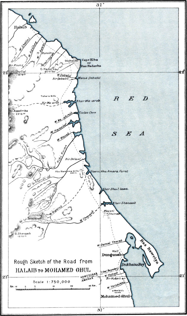
On the completion of the survey work at Halaib in May 1908, I returned to Cairo by marching in to Port Sudan and thence taking steamer to Suez. The journey from Halaib to Port Sudan with baggage camels occupied eleven days, travelling on an average thirty kilometres a day. This rate of travel did not permit of any surveying being done en route, but I took brief notes of the road and the wells on it, and as this road does not appear to be included in those described in the Sudan Handbook, I give here the notes I made. The distances are estimated from the times occupied in marching.
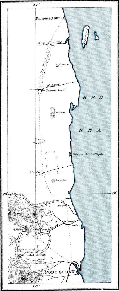
I would mention that from Mohamed Ghul onwards to Port Sudan there are two roads; a lower one near the sea, usually followed by the Police patrols, and an upper one which goes a little distance inland. The upper road was the one I followed, as my guides informed me that while it was only some eight kilometres longer than the lower one, there was much better water to be found on it.
In the sketch maps on Plates XXVII and XXVIII, I have shown the road and the wells on it as correctly as is possible from my notes, using the Admiralty Chart No. 2,336 as a basis for the coast-line and the maps 36 I and 46 A, issued by the Sudan Survey Department, for the position of Port Sudan and some topographical details. As the direction of march was roughly north-to-south and the total estimated distances between Halaib and Mohamed Ghul, and between Mohamed Ghul and Port Sudan, agree pretty well with those scaled from the maps after laying down the terminal positions correctly, it may be taken that the latitudes of the wells are fairly correct, while the longitudes are liable to greater error as being only rough estimations.
Ball—Geography & Geology of South-Eastern Egypt. PLATE XXVII. Photo-Metal-Process. Survey Dept. Cairo 1911. (190) Rough Sketch of the Road from HALAIB TO MOHAMED GHUL
Ball—Geography & Geology of South-Eastern Egypt. PLATE XXVIII. Photo-Metal-Process. Survey Dept. Cairo 1911. (190) Rough Sketch of the Upper Road from MOHAMED GHUL TO PORT SUDAN Scale 1:750,000.
Halaib to Mohamed Ghul.
Place. Kilometres. Description.
Intermediate. Total.
Halaib — — Village of Hamedorab Arabs (reed huts). Small fort of two storeys; tanks below and native police quarters above. No accommodation for Europeans. Several wells, with plentiful water, in and near the village. Water hard and aperient, but drinkable. Fish of good quality plentiful and cheap, from native fishermen. Small quantities of sugar, dates, fat, etc., can be got in the bazaar. No post nor telegraph nor regular communication. Rocks around village are limestones and gypsum, with some calcareous conglomerates.
Wadi Shellal 4 4 Road goes over sandy and gravelly undulating ground near sea. Wadi Shellal is a broad shallow wadi (scrub) coming from high mountains to the west.
Wadi Aqilhoq 3 7 Broad shallow wadi (scrub). About 19 km. up the wadi, west of the road, Bir Frukit, where there is a constant supply of better water than can be got at Halaib.
Wadi Aqwai 4 11 ⎱ ⎰ Shallow wadis with scrub.
Kreit-reit-or 9 20
Ti Kureitra 2 22 Four wells, about 12 metres deep, lined with gypsum-slabs; about 4 km. from coast. Water bad (strongly purgative) only suitable for animals. Gypsum beds, partly covered by gravel, extend over a broad stretch round the wells. Further on, banks of calcareous grit, covered mostly with gravel.
Bir Qabatit 18 40 About 6 km. from Ti Kureitra, mass of high felsite hills called Gebel Hadarba, passed on right of road; road continues over sandy and gravelly undulating ground across shallow wadis draining from the hills. Bir Qabatit is a well in a small wadi south of the main Wadi Qabatit, about 1½ km. from the sea. Water about 5 metres down, very salt, but was being drunk by the Arab patrols, who said it did not purge them.
Bir Ma-arob 14 54 Good road over coast-plain. At Bir Ma-arob, one well of bad water, strongly aperient. Well is in wadi, forming a pool about 2 metres diameter, overhung by tamarisk-bush. Water about 4 metres down from surface. NW. of the well, group of white hills, about 50 metres high, called Tishara, of calcareous grit.
Wadi Na-akreib 8½ 62½ Road over sandy and gravelly plain, here crosses a broad shallow wadi.
Wadi Hamsiat 5 67½ Wadi draining into lagoons.
Wadi Waseb 5 72½ Wadi draining into a great inlet of the sea, looks like a good harbour.
Hibi Kwan 3 75½ Wadi draining into a large inlet. Coast about here much broken, with coral reefs and islets.
Bir Delaut 12½ 88 Good road on to Bir Delaut. Three wells in alluvium of wadi, about 500 metres from sea. Water about 4 metres down. The southernmost well is the best. Water good.
3 91 Road passes head of long inlet, then it passes east of a mass of limestone hills called Abu Hamama, about 200 metres high. A little further on, another big inlet called Halaqa, close south of which are limestone-hills about 150 metres high.
13 104 Road passes west of limestone hills. Further on it crosses the wide and bushy Wadi Shenaab.
14 118 Road turns sharply eastward through low hills (sandstones and grits underlying gypseous limestones, all dipping gently eastwards).
Megwel Shumab 1 119 Road passes close to Megwel Shumab, a shallow pit excavated in limestone with a little tunnel running eastwards. Water very bad, used only by animals.
5 124 Road hitherto over undulating ground, here becomes nearly level.
Wadi Qumat Yawab 10 134 Road crosses broad shallow wadi.
Dungunab 7 141 Small village of huts and tents on coast. Good water at well about 3 km. inland. Mr. Crossland is carrying on work here in connexion with pearl-oyster industry. Meteorological station.
Tribal boundary 9 150 From Dungunab, road detours westward to round an inlet of the sea, then goes over a sandy and gravelly undulating plain with bushes and grasses. Boundary between Hamedorab and Amarar country marked by two wooden posts.
Wadi Hukeib 3 153 Road crosses wadi. High white hills, 10 km. to west of road; as seen through field-glass, these appear to be of white granite seamed by basic dykes. There is a good well, Bir Hukeit-ar, in Wadi Hukeib about 4 km. west of road and 5 km. from sea.
Wadi Yameinai 8 161 Broad wadi, wherein an acre or two has recently been planted with durra. About 6 or 7 km. inland from this point, is a sheikh’s tomb, white and conspicuous in the morning light.
Mohamed Ghul 8 169 Small village on coast. Police fort with two decent rooms above, used by mamûr as office and quarters. No supplies worth mention.
Mohamed Ghul to Port Sudan.
Place. Kilometres. Description.
Intermediate. Total.
Mohamed Ghul — — Small village on coast; see above.
16 16 Road hitherto over gently rising plain of sand with grasses and bushes, here enters hills.
Bir Di-it 1 17 A number of very salt wells, used only by sheep and goats, sunk about 6 metres deep in the wadi bed and lined with masonry.
Bir Salalat Aseir 27 44 Good road from Bir Di-it among granite hills with intervening wadis and small plains, very grassy in places, to Bir Salalat Aseir, a masonry-lined well of good water, about 4 metres deep, sunk in the alluvium of Wadi Aseir. Small settlement of Amarar Arabs here.
2 46 Road after winding among hills, here enters on level plains of granitic sand, with grasses and bushes.
19 65 Rocks change from granite to sandstones and limestones; road now winds among low banks.
8 73 Road goes through east part of a mass of low hills.
Bir Eit 19 92 After passing the above-mentioned hills, the road continues over gently undulating ground with broad sandy wadis with grasses and bushes alternating with strips of igneous gravel. There are low flat-topped hills of limestone (beds dipping gently seawards) between the road and the sea. Bir Eit is on the road; it is a masonry-lined well about 5 metres deep sunk in the wadi-alluvium close to some scarps of white gritty limestone. Water very good. (N.B.—There is another Bir Eit in the same wadi lower down near the sea, of slightly bitter water). Small settlement of Amarar Arabs. Hills round Bir Eit rise at least 100 metres above the wadi, coral overlying marly and gypseous beds.
Low gravel hills 8 100 Road over undulating sandy and gravelly ground to two low gravel hills.
Tower 12 112 Road over sandy plain with dried-up scrub and occasional small patches of igneous gravel, passes 1 km. west of a small tower on a low gravel bank.
Wadi Ga-awit-reb 4 116 Ground broken by drainage-lines. Small trees and a few Arab huts. Megwel Ga-awit-reb, a water source in the wadi a little below where road crosses it.
Bir Ta-amai 11 127 Road over gently rising very sandy ground to Wadi Arba-at, a sandy wadi with numerous trees. Bir Ta-amai is a well in Wadi Arba-at, a little to the west of the road, where the latter passes between two masses of low igneous hills. Water good, about 7 metres down. Rude hut near well.
10 137 Chimneys of Port Sudan here become visible in distance on clear day. Road lies over sandy plain.
Port Sudan 20 157 Rail connexion with Atbara and Suakin. Post and telegraph. Regular steamers to Suez. Permit from British Consul necessary before fire-arms can be taken on board steamers.