Chapter VII
Reading edition
WATER SUPPLIES.[113]
The sources of water in South-Eastern Egypt, as in the Egyptian deserts generally, may be divided into three main classes:—
(1) Springs;
(2) Wells;
(3) Rock basins.
Springs.
As springs are classified those water sources where water issues naturally from the rocks, either above or near ground level, without the aid of artificial excavation. As will be seen on looking through the list of water sources on pp. 244 to 250, springs are less common than wells and rock basins, but some of the best known water sources, such as those of Abraq, Abu Saafa, Abu Hodeid, and Meneiga, belong to this class. The Arabic word for spring is Ain, but the Bedouin seldom use this word, calling springs and wells alike Bir, which properly signifies a well. Small springs are called Megal by the Ababda, and Megwel by the Bisharin tribes.
Springs may occur in any kind of rock, but the rock must be either of a porous nature or must contain fissures. Thus the springs of Abu Saafa and Abraq occur in sandstone, which is itself porous and permits the passage of water through the body of the rock, while the springs of Meneiga occur in a crushed serpentine, which, though not itself a porous rock, is full of fissures and crush-planes, and thus is capable of holding and giving passage to underground waters. It is in consequence of the non-porosity and the comparative fewness of fissures in granitic rocks that springs are seldom seen to issue from rocks of this class.
The collecting areas of the Eastern Desert springs are mostly in the immediate neighbourhood of the springs themselves. Thus, for instance, the springs of Abu Saafa and Abraq are fed by the rainfall on the great sandstone plateaux which surround them, while those of Meneiga are supplied by the rainfall on the mountain mass of Gebel Gerf. In consequence of the fact that the waters do not travel very far underground before they issue from the springs, the water is generally cool. The yield of the springs is usually small, rarely exceeding ten litres a minute from any individual spring, but it is wonderfully constant; the rocks of the collecting area form a huge reservoir which only parts slowly with its water contents, and thus springs may go on yielding supplies when, after a succession of three or four nearly rainless years, many of the wells and rock basins are quite dry.
As a rule, spring waters are very clear and potable. The purest are those which pass through siliceous rocks such as sandstone; where the rocks are rich in lime and magnesia, as serpentines and gabbros, the salt-content of the spring may be fairly considerable, but there is no known spring in this part of Egypt of which the water is so salt as to be disagreable to the taste.[114] It is their constancy combined with the purity of their water that makes the springs the most highly prized of desert water sources.
Springs are mostly on or near the main camel roads, for the roads are naturally selected so as to utilise these constant water supplies. Frequently, however, the spring is situated up a lateral valley some little distance from the main track, and is more or less difficult of access. The springs of Abu Saafa are on a main road, where the Wadi Hodein cuts cleanly through the sandstone plateau; but those of Meneiga, being at the head of a cul-de-sac, are only approachable by a branch track. At large springs the Arabs generally dig out a series of basins into which the water flows, so that these are always full of water ready for the camels of a caravan to drink. At megals there is usually no pool, or only a very small one, in sand or detritus; this sand is scooped out and the water is baled from the hole with a tin can. The absence of a pool is probably due to a desire to check evaporation. The flow at a megal is frequently so small that only a few litres per hour can be obtained; the small trickling spring of Sikait, for instance, was yielding only twenty gallons of water per diem in 1906, but even this small supply was highly prized by the miners working there, on account of its purity as a drinking water.
Megals are more likely to run dry than the larger springs, owing to their smaller collecting area. Any attempt to increase the flow of springs by blasting or excavation would probably only give an increase in yield at the expense of constancy; the throttling of the efflux is doubtless in many cases the chief reason for the perennial character of the yield of a spring, the rainfall being insufficient to maintain greater supplies than the springs yield at present.
Wells.
The wells of South-Eastern Egypt are mostly shallow excavations in the alluvia of the wadi floors, tapping the drainage waters which slowly percolate underground Nilewards and seawards from the mountain ranges. They are naturally more frequent in the districts near to the mountain ranges than in the lower reaches of the wadis, and the best wells are usually in well-defined trunk wadis which collect the drainage from myriads of smaller valleys. The wells sunk in the wadis at points remote from the mountain ranges are of immense importance to travellers crossing from the Nile, forming as they do the only supplies in an otherwise waterless journey of several days.
On an average, water is reached at a depth of eight to ten metres; occasionally, where the wadi is crossed underground by a rocky bar, the natural damming enables water to be reached at very shallow depths. The shafts dug by the Arabs are generally wide and very crooked, in order to permit of a man descending to fill a water-skin. Usually a “well” consists of three or four such shafts sunk in proximity. Occasionally, especially in the Bisharin country, the shafts are lined with rubble masonry, and rough timbers may be stretched across the mouth to facilitate hoisting by ropes. There is never any hoisting gear except at mines; rope is too much prized by the Arabs for it to be possible to leave ropes unguarded at a well, so each caravan uses its own rope and skins. Occasionally, the shaft is so cranked that the water cannot be seen from above. The reason for this is chiefly laziness in excavation; it is easier to deepen a well by driving out laterally a short distance and then sinking a narrow pit, throwing out the excavated material into the larger main shaft, than to hoist all to the surface. Near the wells one usually finds hods, or mud basins, into which the Arabs pour the hoisted water for their animals to drink. Frequently there are high hods for camels and low ones for sheep and goats.
After every considerable rainfall the wells become filled up with stony downwash, and have to be dug out afresh. There is no protective wall to prevent infilling; and, contrary to what might at first be thought, it is not laziness which conditions this circumstance. To the Arab, wells are a last resource. After rain, all the galts (rock basins) are full of good water. The Arab knows that the supplies in these galts will evaporate, while those in the wells, covered in by alluvium, are safe from loss by this cause. He therefore draws his supplies from galts as long as he can, and only when these are empty does he open the wells. The main wells never fail except after unusually prolonged drought, and then the condition of the Arab is sore indeed. The Bisharin do not drink much water, preferring to nourish themselves on the milk of their flocks and herds; but in times of drought the milk supply falls off because there is not sufficient moist vegetation for the animals to feed on.
The quality of water from the wells varies enormously with their situation and at different times. When water is abundant, it is generally good; but as the supply falls off and the wells have to be deepened, the slow infiltration carries abundance of sodium, calcium, and magnesium salts from the rocks, and the water is then often very unpleasant. The following analyses by Mr. Lucas of water-samples from some of the wells in 1906 will give a good general idea of the salts present; the figures give milligrammes per litre (parts per million):—
Sikait Well. Bir Masur. Bir Metawit. Bir Abu Hamamid. Bir Shadli[115] Bir Helie.
I. II.
Total solid matter in solution 7,360 880 4,020 1,720 2,380 2,980 4,040
Cl 1,263 57 1,027 225 555 749 323
SO3 2,530 263 1,042 318 540 776 1,447
Equivalent of Cl as NaCl 2,075 94 1,687 370 912 1,231 530
Equivalent of SO3 as Na2SO4 1,850 1,377 466 550 960 1,377 2,569
Alkalinity to methyl orange calculated as NaHCO3 500 222 550 848 298 260 651
All the above waters were quite drinkable, though that of the Sikait well was rather disagreably salty.
An analysis of the water of one of the Halaib wells in 1895 is given by Dr. Natterer,[117] who found (in parts per million):—
Cl 336
SO4 449
CO3 48
Dr. Natterer records that the sample, which was clear, tasted slightly alkaline, and contained very distinct traces of nitrites and nitrates, free carbon dioxide, free ammonia, and organic matter. During my stay of four days at Halaib in May 1908, I drank regularly of the local well-water; I found it very hard, and though the Arabs seemed to like it, its action on myself was so strongly aperient that I sent into the mountains to Bir Frukit for purer supplies for use on the long march to Port Sudan.
As a rule, it is the magnesium salts which are the most harmful constituents, the sulphate giving a strong purgative character to the water. Such salts are naturally present in greatest quantity where the rocks are gypseous, as for instance along the coast to the south of Halaib, where the wells of Ti Kureitra, sunk in gypsum and lined with blocks of selenite, yield water of so purgative a character that all my Arabs who drank of it became violently ill. In districts where the rocks are of very basic igneous types, such as gabbros and serpentines, the salt-content may also be fairly high. Water from diorite country is somewhat better, that from granite better still, and that from sandstone best of all. There are practically no wells in clayey strata within the region here treated of, but Bir Qoleib, which is on the road from Daraw at about two days’ journey east of the Nile, is sunk at the foot of a clayey scarp, and the water, when I partook of it in 1907, was clouded with clayey matter so finely divided as to be unfilterable through a Berkefeld filter even under strong pressure, while the physiological action of the water was to produce very marked constipation. Wells near the sea coast are liable to be very salty from infiltration of sea water. As a rule, the very salt wells, such as Bir Murra, Bir Muelih, Bir Shalatein, and Ti Kureitra, are used only by camels and sheep. When the Arabs have to drink purgative water for lack of other supplies, they often mix milk with it, and I have found it wise to imitate them in this respect, with liberal addition of brandy in some cases.
Wells are generally named after the wadi in which they occur, e.g., Bir Abu Hashim is the well in Wadi Abu Hashim. A bitter well is often called Bir Murra.[118] A deep well is called Sararat by the Bisharin, e.g., Bir Sararat Seyet is the deep well in Wadi Seyet.
Questions are often asked as to whether it is not possible to increase the available water supplies by sinking fresh wells. Where it is a question of sinking a new well in the middle of a long waterless stretch, or where the object is to sink a fresh well near an existing salty one in order to obtain a drinkable quality of water (and these are the two most usual cases), success cannot be predicted with any certainty, even in the most likely looking spots. We must remember that though the present Arabs may be lazy, the older tenants of the desert were more active. We have only to look at the old mining centres to see this. The probability is that the old miners were just as much worried by the scarcity of water as we are to-day, and with the cheap convict labour then available we may rest assured that every attempt was made to increase the supply. And it is not probable that the Arabs will have allowed to fall into disuse any existing well on an otherwise waterless road, so that it is likely that most of the wells in the wadis remote from the mountains are at spots specially favourable which have been discovered by a laborious process of trial and error. Confirmation of this view is supplied by the failure of new wells sunk at considerable cost in likely-looking places, as for instance at Abu Rahal, where a well carried down to over sixty metres’ depth failed to find water. Where modern wells have obtained water, they have usually been sunk near to or on the site of existing wells, as for instance near the temple of Seti I and at the different mining centres; in these cases it has sometimes been found possible to increase the supply by going deeper. And with regard to obtaining sweet water by sinking new wells near to old salty ones, no success can be hoped for if the saltiness is due to a general salt-content in the surrounding rocks; the Mines Department well in Wadi Mellaha[119] yielded no better water than the Arab well in the same wadi, because the alluvium everywhere in the wadi contains abundance of salt. In some cases, it may be, the promotion of a more rapid flow would lead to a slight lessening in the salinity; but if a well becomes salt merely by evaporation resulting from stagnation, that very fact shows that it is not much used by the ordinary traveller; and moreover the rate of flow of the underground water is not as a rule sufficiently rapid to yield large supplies, even from wide excavations.
In the south parts of the country, where the rainfall is greater, it is possible, nay, even likely, that many new wells could be sunk with success; but in these localities existing wells are more abundant and the necessity for new wells does not arise.
Rock Basins (Galts).
The typical rock basin, called a galt[120] by the Arabs, is a smooth-sided cavity in the rocky floor of a steep gorge draining a large mass of high hills. Galts are generally difficult of access, being situated in the higher parts of very stony wadis, so that one has to tramp often over miles of steeply rising stony ground to reach them. Galts abound in all high mountain-masses in South-Eastern Egypt, and furnish the greater portion of the water supply of the population. The capacity of galts varies very much; some hold millions of litres. Often there is a chain of successive galts at intervals along the length of a gorge, and after rain the whole series is filled, while much overflows and runs to waste. The origin of the rocky basins is generally due to pot-holing action on a large scale. Galts may occur in rocks of any hard type, but are most commonly met with in eruptive rocks. Sandstone galts never remain long full, owing to the permeable nature of the rocks. The large Galt el Aguz near Gebel Um Harba, which from the inscriptions near it was evidently known and used in Ptolemaic times, is in sandstone, receiving in fact the superficial run-off from the same high mass of sandstone hills as furnish the collecting area for feeding by percolation and underground flow the adjacent springs of Bir Abraq and Abu Saafa; but the galt is seldom full for more than a month or two, while the springs are constant.
The water supply of galts depends firstly on the rainfall of the district; secondly, on the existing drainage system; thirdly, on the presence and size of eroded basins along the lines of drainage; fourthly, on the nature of the rocks forming the basin, and, lastly, on the degree of exposure to evaporation. The rainfall in the Eastern Desert is often very local. A series of galts full one year may be dry the next, while those of another area may show a reverse state of things. The drainage system most favourable to galts is one formed by the union of long narrow steep-sided gullies into a single gorge. The presence of basins is conditioned by the steepness of the drainage and the hardness of the rocky floor; if the rocks are soft or much crushed, galts are very unlikely to occur. Again, if the basin is formed of permeable though hard rock, there will be rapid loss by infiltration. Evaporation is generally far less rapid at galts than in open country, because being in narrow gorges galts only receive the sun’s rays for a few hours of the day, and are, moreover, sheltered from winds.
The quality of galt water varies very much with the interval since rainfall and with the nature of the rocks. Sandstone galts are very pure, because of their short life and the siliceous nature of the rock. Serpentine and diorite galts contain magnesium and other salts, and as the loss by evaporation continues the water may become somewhat bitter and purgative by concentration of these saline constituents, though galts never suffer to the extent that some wells do in this respect.
A galt is frequently accompanied by a small spring (megal or megwel); the galt represents the run-off, while the spring receives the percolating water. Thus for months after a galt is empty it may in some cases be possible to obtain water in small quantity by scooping out sand-filled rock cavities close to the basin.
Galts are generally named after the mountain in which they occur, though when large and well known they may have special names given to them, as in the case of the Galt el Aguz mentioned above.
Remarks on Water Transport.
As will be gathered from the map on Plate III, water supplies are seldom more than two days’ march apart in this part of Egypt. For the ordinary traveller it will therefore be usually an ample provision to carry four days’ supply; in special cases, where it is desired to camp for any purpose remote from water sources, special provision will of course have to be made. There is seldom any trouble with the Arabs about their own water, as when their supplies run short one or two camels can always be detached from a caravan to fill their skins from the nearest well, and they are always content to travel day and night for this purpose. With regard to the quantity of water to be carried, I found ten gallons per European per day to be ample, including water for cooking and for one’s personal servants. Water is best carried in rectangular galvanized iron tanks, each holding ten gallons, fitted with a good brass or wooden plug; two of these carried horizontally make a light camel load, and on the march one can add a little in the shape of tents or bedding to the load. I have tried the barrel-shaped galvanised steel tanks used by the mining companies, which hold sixteen gallons each and are easily carried vertically, a pair forming a camel load; but I have found them much more liable to damage than the smaller rectangular tanks, and do not recommend them for regular desert travel.
List of Water Sources.
In the following list I have summarized all the water sources known to me in order of latitude from north to south. I believe the list contains all sources that are of importance, but it is doubtless far from being complete as regards the rock basins of the mountain areas for two reasons. Firstly, the Arabs are often reluctant to point out the sources, more especially in the more arid parts of the Ababda country; and secondly, as already remarked, since the rock basins depend for their supplies entirely on comparatively recent rainfall around them, they vary very much in yield in different years, so that basins which are of great use in one year may be totally dry the next, and vice-versa, and guides seldom take the trouble to point out a dry basin, even if in some other year it may have held a useful store of water.
With regard to the accuracy of the positions given in the list, it may be remarked that in the case of wells actually visited the position is given to seconds, and the localisation may be relied on within at most a few hundred metres; while for wells not actually seen but whose positions were pointed out by guides from some distance, the coordinates are usually only given to minutes, and these positions are uncertain by larger amounts, up to two or three kilometres in extreme cases.
It must not be assumed that water supplies can always be obtained at all the localities named. As already remarked, rock basins will usually only be full if rain has fallen in the district comparatively recently, large rock basins may furnish supplies for a year after rainfall, but the smaller ones last only a few months, weeks, or even days. The reserves are the wells, most of which never run dry except after a succession of rainless years. But when rock basins are full, many of the wells are filled with downwash, and digging must be resorted to in order to re-open them. A traveller arriving at a “well” sometimes finds no evidence whatever of its existence beyond the guides pointing to a spot on the ground with the statement “el bir hena” (the well is here). The explanation is that the well has been filled with alluvial matter washed down the valley by recent rain; but that same rainfall will have filled the rock basins in the hills, and the Arabs leave the digging out of the well until the basins are empty again. In other cases a well may be found to be dry through the water-level having sunk below the depth to which the well was last opened, and by deepening it a foot or so one may obtain a supply.
The notes in the column headed “Remarks,” on the quality of the water of the various sources, are mostly based on the observations of a single year, and must therefore only be taken as general guides. Usually, the shorter the interval since rain has fallen, the better are the supplies, both in quantity and quality.
List of Water Sources.[121]
Name. Latitude N. Longitude E. Remarks.
° ′ ″ ° ′ ″
Galt Um Tundeba 24 55 25 34 45 53 Rock basin in ravine, 1 kilometre from Wadi Um Tundeba. Gave good supply of pure water in 1906.
Galt in Gebel Ghuel 24 54 0 34 39 0 Large rock basins, yielding a good supply in 1905-1906.
Bir Muelih 24 51 35 33 59 52 In Wadi Muelih. Very salt, only drinkable by animals.
Hangalia well 24 50 27 34 35 40 Modern well in Wadi Hangalia, sunk by miners. Supply small and of poor quality.
Galt Um Karaba (Migif) 24 48 48 34 27 55 Large rock basins, yielding a good supply in 1905-1906. Rather difficult of access for camels.
Bir Ghadir 24 48 25 34 47 0 Well in Wadi Ghadir. Filled by downwash in 1906.
Megal el Harami 24 47 34 34 34 15 Small spring in ravine on west side of Wadi Nugrus. Yields for some months after rainfall. Water very good.
Bir Sibrit 24 43 0 33 58 0 Well in Wadi Sibrit; water about 8 metres down, of good quality. Supply stated to be constant.
Bir Murra 24 41 0 34 11 0 Well in Wadi Shait. Water salt, only drinkable by camels.
Hamish mine 24 41 0 34 6 0 Water in mine shafts, that in the westernmost of three shafts good in 1906. Well in Wadi Hamish, close to mines, 15 metres deep, dry in 1906.
Sikait, spring 24 40 50 34 47 10 Tiny trickling spring of good water. Yields only about 50 litres per day, but supply of very good quality and said to be constant.
Sikait, north well 24 40 12 34 46 0 Modern well, sunk by miners. Was yielding fair quantity in 1906, but of mediocre quality.
Sikait, south well 24 39 38 34 47 45 Similar to last; both wells are in the floor of Wadi Sikait.
Bir Um Gubur 24 37 0 34 5 0 Well in Wadi Shait. Water about 8 metres down, good and plentiful in 1906.
Bir Abu Had 24 34 0 34 36 0 Well in Wadi Abu Had, near its head, at junction of two roads to Sikait. Water salty.
Bir Masur 24 31 0 34 13 0 Several wells in floor of small wadi. Water good, about 10 metres down in 1906, but supplies cannot be relied on.
Bir el Ranga 24 26 0 35 13 0 Very salt well, close to sea.
Galt Um Gerifat 24 22 55 34 40 20 Rock basin in gorge off Wadi Huluz. Was yielding good supply in 1906.
Bir Metawit 24 17 0 34 31 0 Well in Wadi Metawit, on road between Bir Shadli and Bir Masur. Said to yield constant supply. Water about 8 metres down, good and clear in 1906.
Bir Khashab 24 16 0 34 23 0 Well in Wadi Khashab. Not to be depended on. Dry in spring of 1906, but yielding a small supply of mediocre character in the autumn of the same year.
Bir Shadli 24 12 3 34 37 55 Spring or well near tomb of Sheikh. Perennial supply of variable quality and quantity. Favourite meeting place of Ababda Arabs.
Bir Abu Hamamid 24 12 0 34 29 0 Well sunk about 7 metres in floor of Wadi Abu Hamamid. Yielding large supplies of rather salty and muddy water in 1906.
Amar Spring 24 10 0 35 9 0 Spring of good water in diorite hills south-east of Gebel Hamata.
Well in Wadi Abu Hamamid 24 7 0 34 26 0 Wells sunk in wadi floor. Dry in 1906.
Bir Helie 24 5 0 34 32 0 Well in Wadi Helie. Excellent water in spring of 1906, but rather salty later on in the year. Quality evidently varies considerably with interval since rainfall.
Megal Um Gunud 23 58 50 35 10 50 A smaller rock basin in Gebel Um Gunud, off Wadi Lahami, near to Galt Um Gunud.
Galt Um Gunud 23 58 10 35 11 20 Rock basin, in Gebel Um Gunud. Yielded supplies in 1906. Accessible from Wadi Lahami.
Megal el Selaia 23 56 55 34 52 50 Small spring in sand at foot of rocks near Gebel Selaia. Yield small and not to be depended on for long after rain.
Galt Batoga 23 51 20 35 21 30 Rock basin at foot of Gebel Batoga off Wadi Kalalat. Water good, plentiful, and fairly easy of access in 1907.
Galt Um Maiyat 23 50 2 35 18 15 —
Galt in Gebel Dahanib 23 44 45 35 9 50 Rock basin in ravine, containing water after rain; about a cubic metre in 1907.
Bir Shenshef 23 44 0 35 23 0 Several small wells in Wadi Shenshef near ruins. Water good.
Bir Abu Hashim 23 41 56 34 4 26 Several wells in alluvial floor of wadi. Water good and plentiful, about 8 metres down in 1907.
Bir Betan, west well 23 38 0 35 3 15 Well in floor of Wadi Betan, about 600 metres lower down than foregoing, close to where Wadi Um Eleiga enters Wadi Betan. Filled by downwash in 1907.
Bir Betan, east well 23 37 55 35 3 35 Well in floor of Wadi Betan, near small seyal tree. Filled by alluvium in 1900.
Galt near Gebel Abu Dahr 23 37 0 35 5 20 Rock basin in north-west flank of Gebel Abu Dahr. Was yielding a good supply in 1907.
Bir Rahaba 23 33 30 35 9 54 Well in alluvium of Wadi Rahaba. Filled by downwash in 1907.
Bir Abu Reye 23 33 0 35 9 0 —
Galt el Aguz 23 32 30 34 35 0 Large rock basin in sandstone, near easy pass over watershed at head of Wadi Arned. Yields excellent water for short time only after rain.
Bir el Gahlia 23 31 0 35 8 0 —
Bir Abu Beid 23 31 0 34 58 0 Well in Wadi Abu Beid. Was yielding a fair quantity of good water in 1906.
Bir el Sunta 23 25 50 34 47 40 Spring forming pool at foot of sandstone scarp of Gebel Abraq. Good water.
Bir Abu Dibesat 23 25 6 34 47 10 Spring forming small pool at foot of sandstone scarp of Gebel Abraq. Water good.
Bir Abraq 23 24 56 34 47 20 Spring forming pool in gully of Gebel Abraq. Supply constant, good, and plentiful.
Bir Gumbit 23 24 0 34 49 0 At edge of sandstone hills; probably a spring similar to those of Abraq.
Bir Orga 23 21 0 35 3 0 Well stated to exist in Wadi Orga el Rayani.
Megal near Abu Saafa 23 19 30 34 48 40 Spring? in small wadi off Wadi Hodein. Unimportant, being close to Abu Saafa Springs.
Abu Saafa Springs 23 18 9 34 47 45 Four springs yielding constant supply of very pure water, at foot of sandstone scarp in Wadi Hodein. Pools easy of access to camels.
Galt in Wadi Gihab 23 17 5 34 48 10 Large rock basin in Wadi Gihab Yakub Abu Derb. Pool of good rain water 6 metres diameter in 1907. Easily accessible to camels.
Bir Um Reit 23 13 36 34 35 3 Well sunk in floor of Wadi Um Reit. Water of mediocre quality.
Bir Dif 23 12 42 34 49 55 Spring forming two pools in the stony bed of Wadi Dif. Water good.
Bir Shalatein 23 8 5 35 36 28 Very salt well near sea at mouth of Wadi Hodein. Drinkable only by camels. Point on administrative boundary between Egypt and the Sudan.
Bir Beida, north well 22 58 6 35 18 10 In Wadi Beida, about 500 metres further down than south well, at a bend in the wadi. Good water, yields three years after rainfall, but supply infiltrates slowly.
Bir Beida, south well 22 57 53 35 18 10 In Wadi Beida, close to where track to Bir Meneiga leaves it. Dry in 1907.
Bir Madi 22 47 46 35 1 48 Well sunk in alluvium of Wadi Madi, at a bend in a narrow gorge at foot of a high granite hill. Plenty of good water in 1907-1908.
Bir Meneiga, north spring 22 47 8 35 12 20 Similar to Bir Meneiga, south spring, to which it is very close. Point on administrative boundary between Egypt and the Sudan.
Bir Meneiga, south spring 22 46 55 35 12 15 Tiny pool in rocky floor of Wadi Meneiga, which refills as fast as emptied. Easily accessible to camels. Water excellent.
Bir Korbiai 22 46 55 35 10 35 Two wells of excellent water in the rocky gorge of Wadi Korbiai. Said to yield for three or four years after rain.
Bir Muqur 22 42 26 35 18 5 Trickling spring with pools in serpentine, in Wadi Muqur. Was yielding about five litres per minute in 1908.
Bir Sararat Seyet 22 41 10 35 1 59 Deep well in Wadi Seyet; filled by downwash in 1907-1908.
Bir Diqdib 22 41 0 35 13 0 Spring? high up in Wadi Diqdib, south part of Gebel Gerf.
Bir Adal Deib 22 40 30 36 4 30 Salt well, close to sea.
Ti Dabei Hamra Dom 22 39 55 35 38 40 Shallow excavations in alluvium and sand in the hills of Hamra Dom, only yielding supplies for a short time after rainfall.
Bir Baaneit 22 39 30 35 18 40 Spring? situated a short distance up Wadi Baaneit. Said to yield constant but limited supplies.
Bir Bint el Dreb 22 34 0 35 9 0 —
Bir Um Rasein 22 29 10 35 20 20 Near Gebel Um Rasein.
Bir Nabit 22 26 50 36 21 50 Close to sea. Probably salty.
Bir Um Bishtit 22 26 33 35 33 45 In narrow winding gorge off Wadi Um Bishtit. Said to yield good water supplies for a year after rainfall and small supplies longer. Full of downwash in 1908.
Galt Osnei 22 25 35 35 50 40 Rock basin in small granite hill; full only after rain.
Meis-heit-ar, north galt 22 22 4 35 35 12 Galt in rocky gorge off Wadi Meisah. Yielding good supply in 1908; preferred to Bir Meisah for quality.
Bir Abu Hodeid 22 22 0 35 17 0 Large and important spring in Wadi Abu Hodeid.
Bir Odis Maaleq 22 22 0 35 16 0 Large and important spring in Wadi Odis, reached by a mountain track from Wadi Delawet.
Bir Meisah 22 21 8 35 35 50 Well-known well in Wadi Meisah. Filled by downwash in 1908. Water said to be of only moderate quality.
Bir Qidmib 22 21 0 35 29 0 —
Bir Abu Ramad 22 20 40 36 26 50 Close to sea. Probably salty.
Bir Shinai 22 20 0 35 15 0 —
Meis-heit-ar, south galt 22 21 15 35 35 20 Galt in rocky gorge off Wadi Meisah. Yielding good water in 1908.
Megwel Adar Aqdeib 22 17 50 35 38 40 —
Megwel Um Edwa 22 16 50 35 32 45 Chain of rock basins and small spring in stony gorge on east side of Hadal Aweib Meisah. Rather difficult for camels. Water good.
Megwel Didaut 22 16 25 35 37 10 —
Megwel Akau 22 14 50 36 21 10 Small spring? on north side of Gebel Elba.
Bir Kansisrob 22 14 35 36 22 0 Large well; water good and plentiful. Bisharin camping ground.
Megwel Hamida 22 14 25 35 47 0 A tiny trickling spring of saline water in a narrow gorge. Rock basin above it, dry in 1908.
Halaib wells 22 13 25 36 38 40 Several wells in village. Water plentiful, strongly purgative to Europeans, though it has no effect on the natives of the place.
Bir Akwamtra 22 13 1 36 17 58 An excellent well at the foot of Gebel Elba; important Bisharin camping ground.
Bir Hilwit Hasium 22 13 0 35 14 0 —
Bir Nubitra 22 12 50 35 46 20 Said to yield only small supply.
Megwel Um Ein 22 12 30 35 39 40 —
Bir Meheriqa 22 12 10 35 56 35 Spring on east side of Wadi Di-ib. Water rather salty, but drinkable and clear.
Bir Kagog 22 11 0 35 16 0 Small well in Wadi Hasium, near its head.
Galt in Wadi Kirir 22 10 0 35 19 0 —
Bir Sararat Serimtai 22 8 50 36 24 15 —
Bir Mashushenai 22 8 30 35 49 30 —
Megwel Aqwem 22 8 0 35 41 0 —
Bir Guqub 22 8 0 34 27 0 Galt and spring? Water good but variable in quantity. Was yielding in 1906.
Bir Salalat O Sir 22 7 23 36 19 0 —
Ti Kureitra 22 5 50 36 46 40 Four wells sunk in gypseous strata near sea; water strongly purgative.
Bir Egat 22 5 0 34 54 0 —
Bir Frukit 22 2 0 36 36 0 Well in Wadi Aqilhoq; water good and plentiful.
Bir Himeitra 22 0 0 35 15 0 —
Bir Qabatit 21 57 55 36 51 17 Well in Wadi Qabatit, 1½ kilometres from sea; water salty, but said not to be purgative.
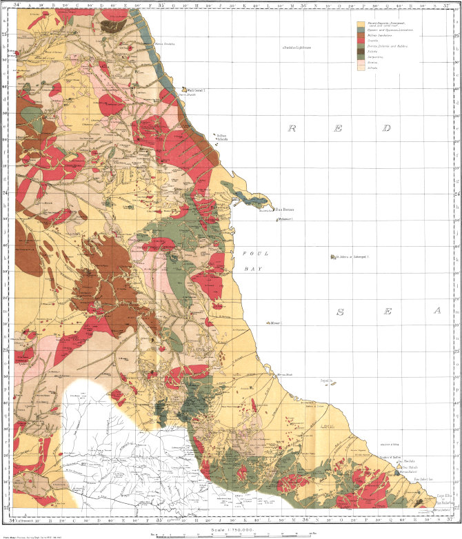
GEOLOGICAL MAP OF SOUTH-EASTERN EGYPT. Ball. Geography & Geology of South-Eastern Egypt. PLATE XX. Photo-Metal-Process. Survey Dept. Cairo 1910. (60-190) (Largest-size: upper, lower, scale)