Chapter XI · (Addenda.) 1526-1614.
Reading edition
After the death of Verrazzano, the French, for a time, made no attempt to search along the coast of the new continent for a short and direct way to Cathay. The losses sustained by the projectors of the expedition of 1526, Ribaut says, gave “small courage to sende thither agayne, and was the cause that this laudable enterprise was left of, vntill the yeere 1534, at which time his Maiestie [Francis I.] (desiring alwayes to enlarge his kingdome, countreys, and dominions, and the aduauncing the ease of his subiectes), sent thither a Pilote of S. Mallowes, a Briton, named James Cartier, well seene in the art and knowledge of Nauigation, and especially of the North parts, commonly called the new land, led by some hope to find passage that waies to the south seas.”[430]
The two ships commanded by Cartier sailed from the port of St. Malo, on the twentieth of April, 1534. Reaching Newfoundland on the tenth of May, Cartier began to search for a navigable channel to India. Three months were passed in exploring the coast of Labrador and the Strait of Belle Isle and a part of the Gulf of St. Lawrence. On the fifteenth of August, Cartier set sail for France, and arrived in the port of St. Malo, on the fifth of September. In the following year, Cartier sailed again to New France and explored the St. Lawrence River to the island of Hochelaga, the site of the city of Montreal. It is said that he was told by the natives that from there it was only “a month’s sailing to go to a land where cinnamon and cloves are gathered.”[431] Returning from this voyage, Cartier reached St. Malo on the sixth of July, 1536.[432]
The first explorers of the new continent called its inhabitants by different names. Columbus and his Spanish companions, imagining the field of their discoveries to be in Eastern Asia, named the aborigines Indians (Indios), believing them to be natives of India. Seven of the people of Canada, carried to France, in 1509, were described by a contemporaneous Latin writer as wood or wild men (homines sylvestres).[433] The French, it appears, called the natives of New France manants or manans, and paysans, peasants, the former name being used in the middle ages as a designation for unintelligent people or those of low condition. The name manants was likewise a designation for persons of this class living in villages and on farms. Manants properly speaking were the natives of a place, and the habitans were those who came to it to reside.[434] The French appellation manants or manans not only fitly expressed the low condition of the natives of New France, but it also gave prominence to the fact that they dwelt in villages and were indigenous people. The French, as late as the year 1677, called the old Indians, or rather the descendants of the Senecas, paisans, peasants.[435] The Italians also called the natives of North America peasants, paesani.[436]
The Manants living on the island on which the city of New York is built, were very friendly to the French who came to the Grande River, in the sixteenth century, to traffic for furs. The Hollanders, however, found them to be quite hostile in the following century. De Laet, the Dutch historian, describing the natives of the Groote River in 1625, remarks: “On the east side, upon the main-land, dwell the Manhattans, a bad race of savages, who have always been very obstinate and unfriendly toward our countrymen.”[437] He also says that Hudson, in 1609, called the Great River “Manhattes from the name of the people who dwelt at its mouth.”[438]
The wrong spelling of the French term manant began with a misconception of its proper pronunciation. The Dutch thinking that the t was sounded, pronounced the name man-ant, whence “man-hat,” “man-ath,” “man-ad,” and other strange forms of the name. Wassenaer, the Dutch historian, in 1624, speaking of the Indian tribes of New Netherland, says: “The Manhates are situated at the mouth” of the Mauritius River.[439] De Laet writes the name Manhattes, Manatthans, Manatthanes, and Manhattans.[440] De Vries, the Dutch navigator, who could speak French, spells the appellation Menates and Minates.[441] In the deposition of Catelyn Trico, a French woman, who emigrated from Holland, in 1624, to New Netherland, the term is written Mannantans.[442] Besides these peculiar changes the name has many other anomalous forms.[443]
When the first French explorers sailed along that massive bulwark of trap-rock, now called The Palisades, rising on the west side of the Grande River to varying altitudes from two to five hundred feet above the level of the stream, and ranging northward and southward a distance of more than ten miles, they were peculiarly impressed with its grandeur, and figuratively called it L’Anormée Berge, (The Grand Scarp.)
The adjective anormée and the noun berge definitely describe the steep and extensive wall of stone which borders the noble river, now bearing the name of a later explorer. Anormé, an obsolete form of the adjective énorme, signifies that which is grand, vast, majestic.[444] The noun berge, besides meaning an elevated border of a river, a scarp of a fortification, a steep side of a moat or of a road, is a designation for certain rocks elevated perpendicularly above the water.[445] In an old French lexicon it is said: “They likewise call in marine phraseology bèrges or barges those great rocks, rugged and perpendicularly elevated, that is to say, uprightly and plumb, as the bèrges or barges of Olone: such rocks as are Scylla and Charybdis, toward Messina.”[446]
A more appropriate name could not have been selected to designate geographically this part of New France than that of The Land of the Grand Scarp (La Terre d’Anormée Berge), or, in more familiar phraseology, The Land of the Palisades. The words, scarp and palisade, are terms of fortification. The first designates the steep slope below the parapet of a fortification, next to the ditch; the second an upright row of strong stakes set firmly in the ground in front of the counter-scarp, on the opposite side of the moat from the scarp.
The mispronunciation of the peculiar geographical name was evidently the cause of its orthography being obscured so soon after it was used as the designation for the elevated border of the Grande River. The more frequent use thereafter of énorme for anormé made the term more unfamiliar. It would seem also that when the name should have been written La Terre d’Énorme Berge, that it was inscribed, La Terre de Normeberge. The change of the qualifying term to a word of two syllables, as norom, norum, nurum, and norim, rendered the name more ambiguous. In like manner the noun berge was corrupted, being spelled bergue, bega, berg, and bagra. In this way the territorial designation became La Terre de Norumbega, La Terre de Norembegue, La Terre de Noromberge, and La Terre de Norembergue, and its meaning and derivation incomprehensible to the descendants of its originators.
Gerard Mercator, on a terrestrial globe, (globus terrae), made in 1541, represents the Grande River as if its channel were filled with anormée bèrges, which he designates with the misspelled name “Anorumbega.”[447] On a map of the world, made about the year 1548, for King Henry II. of France, the appellation “Anorobagra” designates the river of the Grand Scarp.[448]
In the sixteenth century proper names less peculiar in construction than the appellation L’Anormée Berge, were written very irregularly. It is said by Disraeli that Leicester subscribed his name eight different ways, and that Villers is spelled fourteen times differently in the deeds of the family. Lower mentions that the name of Mainwaring, has the remarkable number of one hundred and thirty-one variations in different documents. Even in this age of dictionaries the spelling of uncommon geographical names does not always conform to their orthography. A record has been kept for a number of years of the different ways in which the name of the city of Cohoes, in the state of New York, has been spelled on letters addressed to that post-office, and the extraordinary number of one hundred and ninety-seven changes in the form of the appellation has been registered.
There seems to be but a single statement that might be used to support an assertion that the natives of the country of New France originated the name “Norumbega.” It is in Ramusio’s Italian translation of the French sea-captain’s description of Francesca, in which it is said: “This region is called by the peasants Norumbega.” René Goulaine de Laudonnière, a well-informed French naval officer, who had command of a French fort in Florida, in 1564, contradicts the assertion that the name was transferred from an early map of the eastern coast of Asia, saying: “It is called by the moderns Terre de Norumberge.” André Thevet, the French geographer, who sailed along its coast in 1556, declares that his countrymen called the Grande River “Norombègue,” and the Indians, “Aggoncy.”
One of the earliest accounts of the Land of the Grand Scarp extant is in the discourse of the unnamed sea-captain of Dieppe, written in 1539. Describing the country of Francesca, he says: “Beyond Cape Breton there is a region contiguous to this cape, the coast of which extends west and a quarter southwest as far as the region of Florida, and it stretches full five hundred leagues, which coast was discovered fifteen years ago, by Monsieur Giovanni da Verrazzano, in the name of King Francis and of Madame, the regent, and this region is called by many the land of the French (la Francese), and likewise by the Portuguese, and its termination toward Florida is in 78° west longitude and 30° north latitude.[449]
“The inhabitants of this domain are a tractable people, amiable and agreeable. The country abounds with all kinds of fruit. Oranges and almonds grow in wild forests, with many different varieties of odoriferous trees. This region is called by the peasants (paesani) Norumbega, and between it and Brazil there is a large gulf, extending west as far as the ninety-second meridian.”[450]
In 1540 Jacques Cartier again sailed to New France and ascended the St. Lawrence River. Jean François de la Roque, Sieur de Roberval, was placed in command of this expedition, and, by letters-patent, dated January 15, 1540, was commissioned viceroy and lieutenant-general of the new lands belonging to France in the western hemisphere. Jean Alphonse, an experienced navigator, a native of Saintonge, near the town of Cognac, France, accompanied Sieur de Roberval as chief pilot.[451]
In the manuscript of the cosmography of Raulin Secalart, written about the year 1545, preserved in the National library, in Paris, is a short description of the coast and people of La Terre d’Anormée Berge.[452] The writer, evidently Jean Alphonse, very faithfully describes Long Island Sound, the eastern entrance to the Grande River, when he says: “This river is wider than forty leagues of latitude at its mouth, and within, the width is as much as thirty or forty leagues, and it is full of islands, which extend ten or twelve leagues in the sea, and it is very dangerous on account of rocks and swashings.” These observations are remarkably consonant with those of a later writer: “Long Island Sound, a Mediterranean Sea, separating the island from the main-land of Connecticut, is connected with the ocean at each end of the island and affords a sheltered line of navigation of about one hundred and twenty miles in extent.... Opposite Harlem River is the noted pass or strait called Hell-Gate, which is crooked, and from the numerous rocks, islands, eddies, and currents, is somewhat difficult and dangerous.”[453]
The identity of the river called by the French writer “Norombègue,” now the Hudson, is satisfactorily established by the statement that the water of the river is salty to the height of forty leagues or eighty-eight miles. This fact is incontrovertible. The Hudson is salty or brackish beyond the city of Poughkeepsie, which is about ninety-three miles north of Sand Hook.[454] The assertion could not be verified were it assumed that the description applies to the Penobscot, or the Kennebec, or the Merrimack, or the Connecticut River. It would seem that the writer speaks of the Palisades bordering the west side of the river, opposite the Indian village of “Norombègue,” when he says: “On the side toward the west of the said town there are many rocks which extend to the sea, about fifteen miles.”
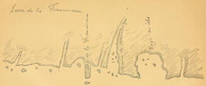
Copy of the map of “Terre de la Franciscane” in the MS. of the “Cosmographie de Jehan Allefonsce et Raulin Secalart,” 1545.
“I say that the Cape of St. John, called Cape Breton, and the Cape of the Franciscan, are northeast and southwest, and range a point from an east and west course, and there are one hundred and forty leagues on the course, and which makes one cape, called the Cape of Norombègue. The said cape is in forty-one degrees of the height of the arctic pole. The said coast [i. e. of Connecticut] is all sandy, ...[455] flat, without any mountain. And along this coast there are many isles of sand and the coast very dangerous on account of banks and rocks.
“The people of this coast and of Cape Breton are an ill-disposed race, powerful, great arrow-makers, and live on fish and on flesh, and are not talkative, and speak almost the same language as those of Canada, and are a great people. And those of Cape Breton go to make war upon those of the New Land when they are fishing, and not for any thing do they spare the life of any one when they take him, unless it is a young boy or a young girl; and they are so cruel that if they take a man having a beard, they cut off his legs and arms and carry them to their wives and children, in order to be avenged in that way. And there are among them many peltries of all animals.
“Beyond the Cape of Norombègue, the river of the said Norombègue descends about twenty-five leagues from the cape. The said river is wider than forty leagues of latitude at its mouth [entrance of Long Island Sound], and within, this width is as much as thirty or forty leagues, and it is full of isles which stretch out ten or twelve leagues in the sea [or Sound], and it is very dangerous on account of rocks and swashings. The said river is in forty-two degrees of the height of the arctic pole.
“Up the said river, fifteen leagues, there is a town which is called Norombègue, and there is in it a good people, and they have many peltries of all kinds of animals. The inhabitants of the town are dressed in skins, wearing mantles of martens. I think that the said river runs into the river Hochelaga [the St. Lawrence], for it is salt for more than forty leagues up, according to the statement of the people of the town. The people use many words which resemble the Latin, and they worship the sun, and are a handsome people, and large framed. The land of Norombègue is high and good.
“Before and on this side of the said river, one hundred and fifty leagues, there is an island called Vermonde [Bermuda?] which is in about thirty-three degrees of the height of the arctic pole.[456] And on the west side of the said town there are many rocks which extend to the sea, about fifteen leagues, and north of it there is a bay, in which there is a small island, which is often subject to tempests and cannot be inhabited.”
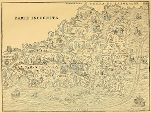
A copy of the map of a part of North America, in the third volume of Ramusio’s “Raccolta di Navigationi e Viaggi,” printed in 1556; made by Giacomo de Gastaldi. (The original is about one-third larger.)
While Jean Alphonse was exploring the coast of La Terre d’Anormée Berge (which at this time geographically included all the country between the Grande River and the Gulf of St. Lawrence), he ascended the Grande River to the height of its navigation, from which point he inferred that the stream extended to the St. Lawrence, as it is represented on the map made by Giacomo de Gastaldi, a Piedmontese cartographer, about the year 1553.[457] “I have been at a bay as far as forty-two degrees, between Norumbega and Florida, and I have not searched the end thereof, and I know not whether it [the river] pass through.... I doubt not but [the river] Norumbega entereth into the river of Canada, and unto the sea of Saguenay.”[458]
This opinion, that the Hudson was an outlet of the St. Lawrence, was held by the Dutch as late as the year 1625, for De Laet observes: “Judging from appearances this river extends to the great river of St. Lawrence, or Canada, since our skippers assure us that the natives come to the fort [on the site of Albany] from that river.”[459]
René Goulaine de Laudonnière, a French officer, commanding Fort Caroline, on the river May, in 1564, gives, in his notable history of Florida, a short account of Verrazanno’s discoveries in 1524.[460] He says that the French planted in the New Land “the ensigns and arms of the king of France, so that the Spaniards themselves, who were there afterward, have called this country French land (nõmé ce païs terre Francesque).... The east part of it is named by the moderns Terre de Norumberge, which ends at the Gulf of Gamas, which separates it from the island of Canada.”[461]
Not long after the discovery of Francesca by Verrazzano, French barques were making voyages to its coast, some to obtain cod-fish and others furs. As related by Jean Alphonse, the people of the village of L’Anormée Berge had “many peltries of all kinds of animals.” The large quantities of beaver, otter, and other skins obtained from the Manants, dwelling at the mouth of the Grande River, induced the speculative Frenchmen engaged in the traffic to erect at this point a small fort, where their factors might reside and more advantageously enlarge their purchases of furs. The Indian village, on the island on which the city of New York is built, was picturesquely situated on the border of the deep, limpid lake, then covering the sites of the plots of ground included between the lines of Elm, Baxter, Worth, and Franklin streets. Near the south end of the lake (which extended as far as the intersection of Centre and Duane streets and emptied into the Hudson at Canal Street) was a small island. Eligible, and opposite the tongue of land on which the Manants dwelt, the French fur factors selected it as the site of the fortified trading house which they erected and called Le Fort d’Anormée Berge (The Fort of the Grand Scarp).[462]
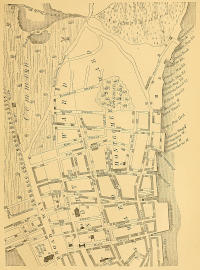
Copy of a part of a map of the city of New York made by James Lyne in 1728.
The French geographer, André Thevet, who sailed along the coast of La Terre d’Anormée Berge, in 1556, besides corroborating some of the preceding statements respecting the discovery of New France, and mentioning the fact that the Grande River was called by his countrymen the river of “Norombègue,” and by the Indians “Aggoncy,” says[463]: “Having left Florida on the left hand with a great number of islands, islets, gulfs, and capes, a river presents itself, one of the beautiful rivers that are in the world, which we named Norombègue, and the Indians Aggoncy, and which is marked on some marine charts Grande river.[464] Several other beautiful rivers enter this one, on which formerly the French had built a small fort about ten or twelve leagues up it, which fort was surrounded by fresh water that empties into the river, and this place was called the fort of Norombègue.”[465]
The site of the fort of L’Anormée Berge is indicated by Gerard Mercator on his celebrated map of the world, made at Duisburg, Germany, in 1569. The famous cartographer not only designates the situation of the French fort on the east side of the Grande River with a conventional sign used by map-makers, but also inscribes the name “Norombega” immediately over it. As is seen, he outlines the Grande River to the height of its navigation, at the confluence of the Mohawk, as far as the French had explored it.[466]
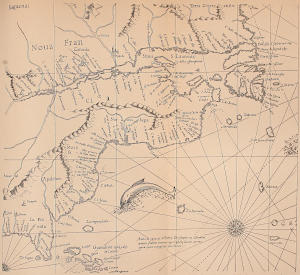
A part of Gerard Mercator’s map of the world, made in Duisburg in 1569; copied from “Les monuments de la géographie recueil d’anciennes cartes européennes et orientales, publiés en fac-similé.” par M. Jomard, Paris.
It seems that the French fur merchants undertook to build, about the year 1540, a château or castle, at the height of the navigation of the Grande River. As it appears, they selected a site for the building on the long, low island lying in the bay, on the west side of the river, near the present southern limits of the city of Albany. The walls of the castle and its protecting earthworks were almost completed when a great freshet inundated the island and damaged the structure so much that the French abandoned the occupation of the island. Jean Alphonse evidently refers to the abortive undertaking, when describing the situation of the Indian village at the mouth of the Grande River, he says: “North of it there is a bay, in which is a small island that is often subject to storms, [those causing freshets,] and cannot be inhabited.” The island bore the name of Castle Island for more than a century thereafter, but it is now known as Van Rensselaer’s Island.
The fact that the French had ascended the Grande River to the height of its navigation to trade with the Indians long before Henry Hudson explored it, is corroborated by still stronger testimony than that already presented. One of the earliest maps representing the territory of Nieu Nederlandt (New Netherland), or that part of New France which the French had called La Terre d’Anormée Berge, is the figurative chart presented to their high mightinesses, the Lords States General of the United Netherlands, on the eleventh of October, 1614, by a number of Dutch merchants, praying for a special license to navigate and traffic within the limits of this part of North America.[467] Upon this map, made in 1614, are inscribed “curious notes and memoranda concerning the natives of the country,” which the well-informed discoverer of the chart intimates were written by one of the Dutch companions of Henry Hudson, who accompanied the English navigator, on the voyage of 1609.[468] One of these explanatory notes contains the undeniable testimony that the French were the discoverers of the Grande River, and that they had been trading with the Mohawks long before the Half Moon sailed up the river. The plain language of the inscription makes all explanation of its meaning unnecessary: “But as far as one can understand by what the Maquaas [Mohawks] say and show, the French come with sloops as high up as their country to trade with them.”[469]
Among the things which were shown to the Dutch explorers by the friendly Mohawks to confirm what they had said concerning the French, were the conspicuous ruins of the unfinished castle. The sagacious Hollanders, not unlikely thinking that the dilapidated building might be repaired with little expense, and made useful to them as a trading house, should they be licensed by the government of the Netherlands to return there to trade for furs with the Indians, took measurements of its walls and outworks. These memoranda they also inscribed on the map of New Netherland. The castle, as described on the chart, was fifty-eight feet wide between the walls, and built in the form of a square, surrounded by a moat eighteen feet wide. The interior building was thirty-six feet long and twenty-six wide.[470]
Although the Dutch explorers never left any definite information that they were personally the builders of the fortification on Castle Island, yet by naming it Fort Nassau, in honor of the stadtholder, Maurice, prince of Orange and of Nassau, they permitted historians to infer that they had constructed it, even before they had been privileged by the government of the Netherlands to occupy the country.
As late as the year 1680, the Dutch residents of Albany were unenlightened respecting the nationality of the builders of the fort, some supposing that the Spaniards had erected it. This assumption was not generally credited, as there were no facts known that would verify the presence of the Spaniards in this part of the country. The two Labadist missionaries, Jasper Dankers and Peter Sluyter, who visited Albany in 1680, thus speak of the fort on Castle Island, and of the conjecture concerning the people who had built it: “In the afternoon [Sunday, April 28th] we took a walk to an island upon the end of which there is a fort built, they say, by the Spaniards. That a fort had been there is evident enough from the earth thrown up, but it is not to be supposed that the Spaniards came so far inland to build forts when there are no monuments of them to be seen on the sea-coasts, where, however, they have been according to the tradition of the Indians.”[471]