Chapter IV · THE PLANT FORMATION Methods of Investigation and Record
Reading edition
198. The need of exact methods. The use of instruments in the study of the habitat has made it evident that the loose methods of descriptive ecology were altogether inadequate to the accurate investigation of the formation. This feeling has been heightened by the recognition of the fact that vegetation exhibits both development and structure, and is, in consequence, open to exact methods of inquiry. In the search for feasible methods, it was quickly seen that the quadrat, first[20] used for determining the abundance of species, furnished the key to the problem. Accordingly, the principle underlying it, viz., that of intimate detailed study and record, was developed and extended in such a way as to give rise to a number of methods of precision. These have been applied in the field for several years with signal success, and they are here described in the conviction that they constitute a satisfactory system, if not, indeed, the only one for the exact study of formations.
There has been a growing appreciation of the fact that the superficial methods of descriptive ecology made it impossible to build upon such a foundation, and they, indeed, were making actual progress in the field of ecology more and more difficult. Ecologists have now begun to see clearly that precise methods are as indispensable in the habitat as they are to the study of the structure and modification of the plant. For some reason, however, they have been slow to perceive that accuracy in the investigation of the cause, the habitat, is a fruitless task unless it be followed by corresponding exactness in the study of the effect, the formation. After having urged the fundamental necessity of instrumental methods, for six or seven years, both in season and out of season, the writer does not feel called upon to further plead the cause of the quadrat. The final acceptance of the instrument was inevitable if progress were to be made in the habitat, and it is just as obvious that the quadrat must be accepted if the study of the habitat is to bear fruit in the interpretation of the formation. The use of the quadrat does not mean that the general methods of descriptive ecology are all to be discarded, whether they have value or not. The statement that quadrat methods are indispensable signifies merely that they must be used for research work in the development and structure of vegetation. They are 162not necessary in reconnaissance, nor do they displace general methods of real value. The use of the latter in even a supplementary way will gradually be discontinued, however, as fields become smaller by reason of increase in the number of workers, and as the need for precise methods becomes more universally felt.
The quadrat constitutes the initial concept from which all the methods have grown. In itself, it has given rise to a variety of quadrats applicable to the most fundamental problems of vegetation. From it have come, on the one hand, the migration circle, and on the other, the transect. The latter in turn has yielded the ecotone chart, and the layer chart. All of these are based upon direct and detailed contact with vegetation itself, and permit accurate recording of all the results obtained.
QUADRATS
199. Uses. In its simplest form, the quadrat, as the name implies, is merely a square area of varying size marked off in a formation for the purpose of obtaining accurate information as to the number and grouping of the plants present. As indicated above, it was first used for determining the abundance of the various species of a formation. This made it possible to ascertain the relative rank of the species of layers and formations, and enabled one for the first time to gain some idea of the minute structure of a bit of vegetation. The results were at once applied to the task of establishing a numerical basis for abundance, and of working out a new system of abundance to correspond. The quadrat method was also used to determine the character of seasonal aspects, and to yield a knowledge of the exact differences in diverse areas of the same formation. Incidentally, the determinations of abundance were made the basis of an actual census of certain alpine formations. This, while it was extremely interesting to find that a square mile of alpine meadow contained approximately 1,500,000,000 plants, was confessedly destitute of ecological value. The most important applications of the quadrat idea were made by Clements[21] in the chart, the permanent and the denuded quadrats. The development of these was due to the fact that zones or formations permit of comparison upon floristic as well as physical grounds, and that a detailed record of their structure is necessary for this purpose. Similar comparisons are necessary for the consocies, zones, and patches of the same formation, and the quadrat becomes an indispensable means for studying alternation and zonation. For the investigation 163of invasion year by year, and especially for succession, the method of permanent quadrats is imperative, and the denuded quadrat an invaluable aid. Changes, which would otherwise be incompletely observed and imperfectly recorded, are followed in the minutest detail and recorded with perfect accuracy.
200. Possible objections. The use of the quadrat has led to the criticism that it is needlessly detailed and thorough, and that, after all, the space covered is but a minute part of the entire formation. The first objection is one that has also been urged against the use of instruments of precision in the habitat. It is always brought forward by those who have not used instruments, and as witnesses they are of necessity incompetent. No one who is familiar with the instrument or the quadrat by actual practice has felt that the methods based upon them were too thorough. In no case has the writer ever listed or mapped a quadrat without discovering some new fact or relation, or clearing up an old question. It can not be denied that quadrat methods require both time and patience, but this is true of any kind of research work that is at all worth while. Every ecologist, moreover, that has the interests of his field at heart and deprecates the present slipshod work, will appreciate the necessity of methods which seem like drudgery to the mere dabbler.
The second objection, that the quadrat is at best but a small bit of the area under investigation, seems at first to be a valid one. It can not be gainsaid that the actual space studied is insignificant as compared with the whole formation; still, it must be obvious that even a single quadrat can add at least some facts of value, which can never be obtained by the best of general methods. Furthermore, if the formation be an actual and not an imaginary one, a single quadrat will be in some measure representative. In the more homogeneous ones, it will have much the same value that a type specimen bears to the species established upon it. In formations which are less uniform, its value is correspondingly reduced, so that in formations which show marked zones, consocies, or patches, it becomes necessary to locate a quadrat in each. In the matter of representation alone, the graphic method of the quadrat map with its close-focus detail photograph, is far superior to anything that can be obtained by the ordinary description and photograph. Finally, the scientific study and recording of succession, and particularly of competition, is an impossibility without the aid of the permanent and denuded quadrat. The stoutest champion of the practice of walking through a formation, and jotting down impressions, can not avoid their use if he would attack these problems, and, once familiar with the quadrat, his objections to the drudgery of thoroughness will soon vanish.
164
Kinds of Quadrats and Their Use
201. Size and kinds. The unit size of quadrat is the meter, and when the term is used without qualification, it refers to the meter quadrat. To make them strictly comparable, and exactly divisible, unit quadrats are always grouped in squares; thus a major quadrat is a square of four units, and a perquadrat one of sixteen units, or four meters square. Quadrats of greater size are necessary in woodland and forest, where the rule, however, is that the woody plants alone are recorded for the whole quadrat, the herbaceous growth being listed or mapped for but one or two representative units. For special purposes, quadrats of 3, 5, 6, etc., meters may be used, but they are much less convenient. Quadrats are further distinguished with respect to their use. A list quadrat is one in which the plants are merely listed and the number of individuals of each species indicated. Chart quadrats are those in which the area concerned is accurately mapped on plotting paper. Both list and chart quadrats are rendered permanent by careful labeling, so that their changes can be followed from year to year. The greater value of the chart causes practically all permanent quadrats to be of this type, and for the same reason only permanent chart quadrats are converted into denuded ones.
202. Tapes and stakes. The lines for marking out quadrats are made of strong white tape, ⅝ inches wide. This is doubled and sewed firmly at both edges. Under moderate stretching, the tape is carefully marked off into decimeters, and eyelets 5 mm. in diameter are set in at each end and at the marks. This can readily be done by any shoemaker at slight expense. The usual lengths are one and two meters, as these are most frequently used, and they can also be easily combined to make larger quadrats. The tapes are slightly longer than one meter in order that the distance between the end eyelets may be exact. The tapes of the larger forest quadrats should be divided into lengths of one meter, as these permit ready plotting and also make it possible to interpolate a meter quadrat for the study of the undergrowth at any point. The intervals of the tape are numbered from left to right, as conspicuously and clearly as possible. For this a waterproof ink or paint is very desirable. For holding the tapes in position, hatpins, nails, and meat-skewers have been used with more or less satisfaction. The ideal stake, however, is one which holds the tape close to the ground, and can be readily moved. It is merely a stout wire, 3 mm. in diameter and 8 inches long, looped at the top, sharpened at the tip, and with a small ring of solder 3 inches from the tip.
165203. Locating quadrats. In staking a quadrat, the end tapes are invariably placed so that the numbers read from left to right, and the side tapes so that they read down. In mapping, a fifth tape is stretched parallel to the top, and as each decimeter strip is marked, the outer tape is shifted to delimit the new strip. Indeed, the side tapes can be placed alone, and the plotting tapes moved down one at a time as the mapping proceeds, but it is usually more satisfactory to locate the quadrat exactly and to square it first, a task most easily done by enclosing the whole quadrat, and then using a fifth tape. In the case of list quadrats in open vegetation, the measuring strip is unnecessary, but as a rule it facilitates counting, as well as mapping.
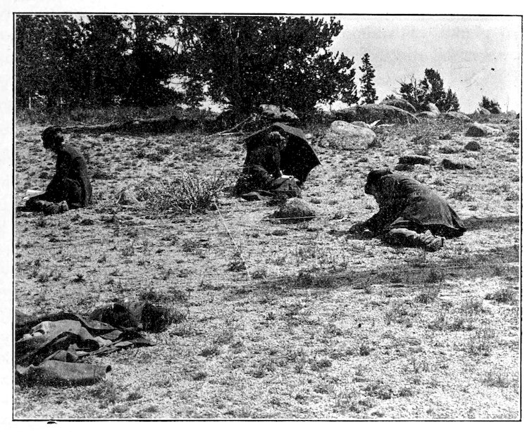
Fig. 50. Mapping a major quadrat on Mount Garfield at 3,600 m.
The List Quadrat
204. Description. This, as the simplest form of quadrat, is employed primarily to ascertain the abundance of species in a formation or during a particular aspect of it. Since this can be obtained readily from the chart, the list quadrat has fallen more and more into disuse, except where it is desired to determine abundance alone, or to aid in deciding whether a chart is really representative. The size depends almost wholly upon the nature of the vegetation. When the number of trees is to be determined, a quadrat of 10 or 50 meters is necessary. In ordinary herbaceous formations, the usual size is 2 meters, while the meter quadrat is used when the 166plants are especially small and crowded, as in alpine meadows. The location of the quadrat is based upon the general rule, but since its especial task is the determination of the greatest variable in vegetation, viz., number, it is necessary to use more quadrats, and to place them in areas which show the greatest differences in the mixture of species. For example, it was found that a half dozen list quadrats, when carefully located in the prairie formation, gave results almost identical with those obtainable from a larger number. With a little experience, the various degrees of mixture can be picked out superficially, and the corresponding number of quadrats established. If a single list quadrat is to be made for a formation or station, such a time should be selected as will make it possible to cover the greatest number of plants. Fortunately, this usually falls near the middle of the summer, when the remains of spring plants are still in evidence, and the autumn ones are sufficiently developed to be recognizable. In taking the census of different aspects, the quadrat should be made as near the middle of the period as is possible.
205. Manner of use. In listing a quadrat, i. e., counting the individuals of each species, the plan followed is to list the smaller, less conspicuous plants first, since they are apt to be tramped down. As a rule, the outside tapes and the taller species afford sufficient landmarks. When this is not the case, the measure tape is used, and the individuals of all species are checked as they are found, while in the first method one species, rarely two, is taken at a time. In cases of peculiar difficulty, it may be permissible to pull or break plants as they are counted, but ordinarily this can and should be avoided. Clusters, and bunches of stems from the same root are counted as single plants, and the number of stems indicated by an exponent. In the case of bunch grasses, each bunch counts as one plant.
206. Table of abundance. The species are arranged in the final list in the order of their numerical importance, and are divided into groups which correspond to the different degrees of abundance. The latter are arranged in two series, based upon the fact that association is by groups or by individuals. The table of abundance, based upon a 2–meter quadrat rather than upon the 5–meter one, by means of which the earlier results were obtained, is as follows:
Social exclusive, no other species of vascular plants present
social inclusive, above 100
gr1 gregarious1 100–50 copious1 cop1
gr2 gregarious2 50–25 copious2 cop2
gr3 gregarious3 25–10 copious3 cop3
sg subgregarious 10–5 subcopious sc
vg vixgregarious 5–1 sparse sp
167It is obvious that the above outline is faulty inasmuch as it takes no account of the height and width of the individuals. This is a serious defect, and it constitutes one of the many reasons why the list quadrat should be replaced by the chart quadrat. The prairie formation affords an unusually striking illustration of this. A single quadrat may be filled by ten plants of Psoralea floribunda, and at the same time contain 22,000 plants of Festuca octoflora. Yet the former is conspicuous and controlling, the latter plays an altogether insignificant role. This difference is readily shown by comparing a plant of each. The one is 3 × 3 feet, the other 3 × ¼ inch. Such figures furnish a valuable check upon mere number, but make the brief, graphic designation of abundance difficult. An attempt has been made to solve this problem by roughly determining the space occupied by the plant, by means of the formula, height (πR2) × abundance. This would give Psoralea a value of 210, and Festuca one of 1.6, which much more nearly represents their real importance in the formation. Abundance or numerical value is a floristic concept entirely, and has little place in ecology unless checked in the way indicated. The whole problem, ecologically, depends upon an intimate knowledge of competition, and its solution in consequence is at present impossible.
The Chart Quadrat
207. Description and use. The detailed labor required in mapping makes it advisable to use the meter quadrat. An additional reason of much importance is furnished by the desirability of securing a detail photograph of the quadrat. This is impossible with field cameras, which should not exceed 6½ x 8½ inches, and are indeed most serviceable in the 4 × 5 size, if the area be larger. In open formations, the major quadrat of 2 meters can be used if necessary, but this is very rarely the case. Forest quadrats of ten meters square are easily charted, but detail photographs can not be made of them. Larger quadrats are impracticable; they can be counted but not mapped to advantage. The location of the chart quadrat must be decided by the structure to be studied. Its greatest service is in connection with zones and societies of the same formation, which can be easily compared in the chart form. In fact, the chart quadrat may well be regarded as the fundamental method for inquiry into zonation and alternation. It is an important aid in delimiting areas from the contiguous formations, and in determining the relationships of mixed formations. It is also used to record the character of the different aspects, but this is done more satisfactorily by the permanent quadrat.
168208. The chart used is a decimeter square, and the scale is consequently 10 : 1. It is outlined on centimeter plotting paper, and the centimeter squares are numbered at the edges to correspond to the intervals of the quadrat, i. e., the top and bottom lines are numbered from left to right, and the side lines from top to bottom. These outlines are ruled in quantity and used as needed, or the forms can be furnished by the printer. In practice, a special quadrat book the size of the chart has been used. The need of a second book may be avoided by outlining two charts on the plotting sheet, and filing the latter in the field record book. In the few cases where 2–meter quadrats are desirable, four charts are used, care being taken to label them so that they can be combined whenever necessary. Ten-meter quadrats are recorded on the decimeter chart also, each meter interval corresponding to a centimeter, i. e., the scale is 100 : 1.
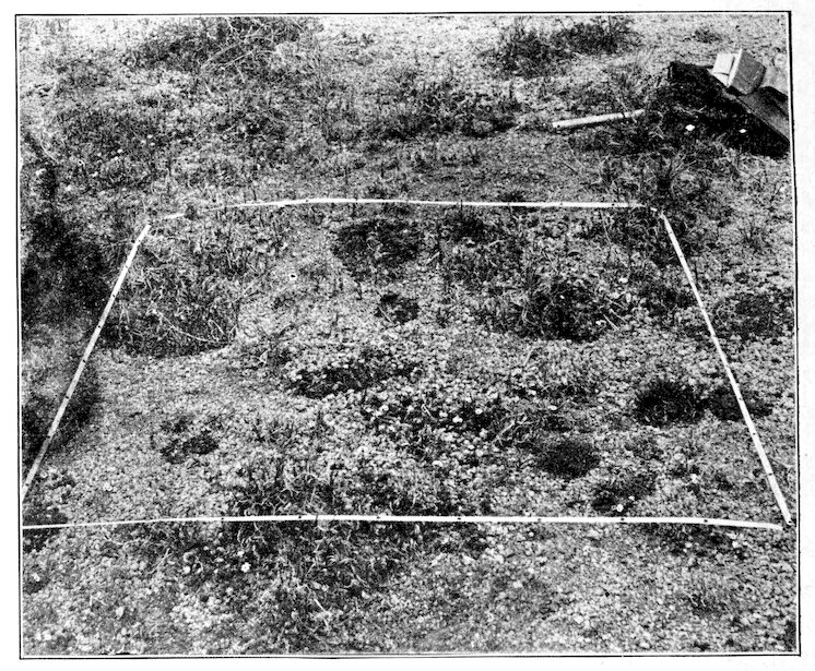
Fig. 51. Permanent chart quadrat, Andosacile, Carex-Campanulacoryphium.
169
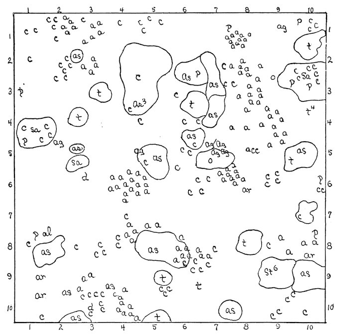
Fig. 52. Chart of the quadrat shown in figure 51. Legend: a, Androsace chamaejasme; c, Carex rupestris; t, Tetraneuris lanata; p, Potentilla rubricaulis; as, Arenaria sajanensis; ar, Artemisia scopulorum; ag, Agropyrum scribneri; sa, Silene acaulis; st, Sieversia turbinata; d, Dasyphora fruticosa; al, Allium reticulatum; o, Oreoxis alpina.
209. Mapping is invariably begun at the upper left-hand corner of the chart, and is carried across the strip marked off by the plotting tape, decimeter by decimeter. As soon as this strip is completed, a second one is formed by moving the top tape to a position one decimeter below the plotting tape, which then becomes the upper one. This is repeated until the last strip is reached. Little difficulty is experienced in locating each plant exactly, as the decimeter interval is small, and the centimeter square which corresponds is divided into twenty-five tiny squares. Each plant is put in whenever possible, but mats, turfs, and mosses are merely outlined in mass if the individuals are not distinguishable. This holds true of all large rosettes and mats, even when they are single plants. Symbols were formerly used for indicating the various species. They have the advantage of requiring little space on the chart, and the disadvantage of necessitating constant reference to the legend. They are at present replaced by initials. By this plan, the decapitalized first letter of the generic name is used if no other genus found in the quadrat begins with the same letter. If, however, two or more genera begin with a, for example Agropyrum, Anemone, and Allium, the most abundant 170one is indicated by a, and the others by the first two letters, as an, al. In case two species of the same genus are present, the species initial is used in connection with that for the genus, as ac and ar for Agropyrum caninum and Agropyrum richardsonii respectively. It is rarely necessary to exceed two letters for any species. Plants which regularly have several stems from the same root are indicated by the initial and an exponent as a3. Seedlings are represented by a line drawn through the letter. Usually the chart sheet affords sufficient space below the chart for the legend. When the list of species is long, the back of the sheet is used.
210. Factors and photographs. Each chart is numbered, and the formation, station, and date indicated. The constant factors, altitude, slope, and exposure are ascertained and recorded on the sheet. The variable factors are read in each quadrat whenever possible, and in addition to being preserved in the record book, are noted on the chart sheet along with the base reading in the formation for the same time. This facilitates the interpretation of the differences found when two or more charts are compared. Chart quadrats are regularly photographed. For this purpose a long focus 4 × 5 camera with a telephoto lens is used. At the proper distance this will make a view of the same size as the chart, thus making possible an exact comparison of the two. The chart and photograph serve as mutual checks, as well as complements, since the former shows number, position, and arrangement, and the latter, height, form, position, and arrangement. The view is usually made by placing the camera directly in front of the middle of the lower tape, at such a distance that the side tapes fall just within the limits of the ground glass. The swing is always used in order that the focus may be uniformly sharp. Surface views of the quadrat can be taken by means of a device which permits the camera to hang downward from the tripod, or by means of a tripod with a swinging platform. Such views are especially valuable for the study of competition, since they give a clear idea of the spread and density of the various plants. They are difficult to make unless the vegetation is low and nearly uniform in height. The usual photograph is much more serviceable in regular quadrat work.
The Permanent Quadrat
211. Description and uses. As stated heretofore, either list or chart quadrats may be rendered permanent in order that they may be followed from season to season or from year to year. As a matter of fact, however, an area which is to be studied repeatedly really demands charting, and in practice chart quadrats alone are made permanent. This is done simply by driving 171a labeled stake at one corner of the quadrat, and locating the latter definitely in relation to a conspicuous landmark. When one is in residence for several years, practically all chart quadrats are converted into permanent ones, since the work already done in the chart quadrat is so much accomplished towards the permanent one. This is not necessary when one wishes merely to compare different areas of stable formations. As a rule, however, some change is constantly being wrought by invasion or competition, and the amount and direction of this can only be revealed by the permanent quadrat. The latter has a fundamental value for all kinds of invasion, but it is absolutely indispensable in studying complete invasion or succession, and in discovering and recording the gradual effects of competition. It is in the detailed investigation of these dynamic phenomena that the paramount importance of the quadrat is most evident. If the experience of several years be taken as conclusive, no other method is capable of revealing the minute changes as they are occurring.
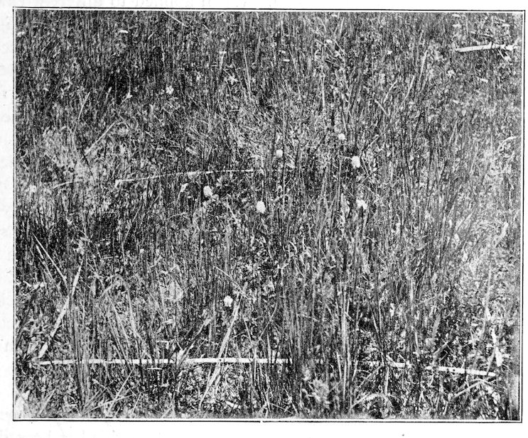
Fig. 53. Permanent quadrat, Polygonile (Polygonum bistortoides) Ruxton Park; mapped and photographed July 22, denuded September 8, 1903.
The permanent quadrat is regularly 1 meter square, a size determined both by the exigencies of charting and photographing. When ecograph batteries are used, the quadrat is located as close to the latter as is possible. Otherwise, 172the quadrat itself should constitute a station for making factor observations. This connection is absolutely essential, since the quadrat is used expressly to determine the structural changes, which are produced by physical factors, and the reaction of vegetation upon them. Permanent quadrats are established in different formations or stages of a succession to trace the invasion of new species and the dropping out of old ones in response to competition. They serve to distinguish the proper formation, which represents a particular stage of development, from the mixed formations which precede and follow, and also to determine the exact course as well as the rapidity of the change that follows each reaction. When applied to different examples of the same stage, and to all the different stages of a succession, the whole development of the latter may be minutely traced and definitely recorded. The importance of following the changes from aspect to aspect is much less, since these are periodical rather than dynamic. They are an essential feature of structure, however, and it has been the practice to make at least one series of aspect charts from each permanent quadrat.
For tracing the invasion and competition of lichens and mosses, which play a primary role in initial formations, a subquadrat is used. The size varies, but it is usually smaller than the quadrat, although the latter is entirely available in the case of the large foliose lichens. For the crustose and smaller foliose forms, a subquadrat 2 decimeters square is used, and for the larger forms and tufted mosses, one of 5 decimeters. In the case of ground forms, tapes are employed, and the quadrat is permanently staked. On rocks and cliffs, where moss and lichen stages are most common, tapes are impracticable, and the quadrat is permanently outlined with paint. Charts of lichen quadrats are made to the usual scale of 10 : 1.
212. Manner of use. Permanent quadrats are mapped and photographed in exactly the same way as chart quadrats. As soon as this has been done, a labeled stake is driven at the upper left-hand corner, so that its edge indicates the exact position of the quadrat stake, and a smaller one is placed at the opposite corner to facilitate the task of setting the tapes accurately in later readings. The label stake bears merely the number of the quadrat and the date when it was first established. It is firmly fixed and allowed to project just enough to enable it to be located readily. Its position requires careful landmarking when the quadrat is to be visited year by year. In forest formations, this is readily done by blazing, but in grassland it is necessary to have recourse to compass and pacing, or to erect an artificial landmark. After several charts have been made, a permanent quadrat attains a high value, and every precaution must be taken to prevent losing its exact location. At the second reading of a quadrat, whether in the succeeding aspect 173or year, the tapes are placed with reference to the stakes, and a chart and photograph are made in the usual manner. These are labeled and dated like the original ones, but they are numbered to indicate both the quadrat and the series, e. g., 152 indicates the second chart, and photograph made of quadrat 15. The date indicates whether the readings are by the aspect or the year, though this may be shown also in the name of the series itself. It is clearly an advantage to have the two successive charts of a quadrat upon the same sheet, and to file all the charts and photographs of the same permanent quadrat together, and in the proper order.
Since much of the value of a permanent quadrat depends upon its use as a station for observing physical factors, it is unprofitable to establish a large number. The results of invasion and competition can be ascertained by the quadrat alone, but these should be merely preliminary to seeking for their causes. Clearly, a quadrat should be established for each battery of instruments, while additional ones should be located only in so far as they can be visited often enough to give an insight into the factors that control them. In view of the fact that the most important factors, water-content and light, are less variable than humidity, temperature, and wind, it will suffice if visits are made once a week. This is especially true when it is possible to refer the more variable factors to the continuous records of a base station. While all the results determined for permanent quadrats are preserved in the field record, a record of them is also kept on the reverse of the chart sheet for convenience in interpreting the different charts.
The Denuded Quadrat
213. Description. This is primarily a permanent quadrat from which the plant covering has been removed, after it has been charted and photographed. What is practically the same thing is obtained by establishing a permanent quadrat in a new soil, or in one recently laid bare and not yet reclothed with plants. These, however, are merely permanent quadrats, in which the first chart and photograph furnish a record of the habitat alone. They are of great importance in succession, and will be more fully discussed under experimental vegetation. The denuded quadrat is of the usual size, 1 meter, though the smaller lichen quadrats are also denuded. The location is subject to the conditions already indicated, especially with reference to physical factors. The denuded quadrat, however, is particularly adapted to the study of invasion and the resulting competition. Consequently, when migration is markedly from one direction, a series of denuded quadrats throws a flood of light upon the actual steps in invasion. Denuding is a valuable aid in succession, but it must be clearly recognized that, while permanent quadrats 174register the exact course of the succession, denuded ones can merely furnish facts as to the probable courses of stages not now in evidence.
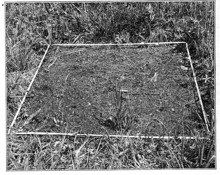
Fig. 54. Denuded quadrat; this is the quadrat shown in figure 53; photographed September 7, 1904.
214. Methods of denuding and recording. Permanent quadrats may be denuded at any time during the time they are under observation. The best results, however, are to be obtained by establishing the two side by side, or at least close together. In this way, they are mutually supplementary, and furnish the most evidence possible with regard to the procedure of invasion and competition. Another advantage is found in that the same observations of climatic factors will do for both, though water-content and soil temperatures are necessarily different. A quadrat which is to be denuded is first mapped, photographed, and labeled exactly like a permanent quadrat. The vegetation is then destroyed. This is usually done by removal, though it may also be burnt, destroyed by flooding, or in some other manner. The method will depend upon the use which the quadrat is to serve. If it is to throw light upon the vegetation of an area in which denudation has affected the surface alone, the aerial parts only are removed by paring the surface with a spade. When the disturbance is to be more profound, the upper seed-bearing layer is removed, and the underground parts dug up. In the interpretation of a 175secondary succession, the denuding cause is made use of in a fashion as nearly natural as possible. Ordinarily, the plants are removed just below the top of the ground by a spade, leaving the underground parts undisturbed. This method has yielded very interesting results.
Quadrats have been denuded in the fall after the majority of the plants have completed their growth. This is largely owing to the fact that other field work is less pressing at this time. Denudation can be done as well in the spring, though the invasion will be slower in this case, since the seeds which have accumulated will be partly or entirely removed. During the first season the denuded quadrat should be mapped every month, and, if the invasion be rapid, photographed also. In open formations, especially those of a xerophytic nature, a single chart and photograph made at the end of the season are sufficient. In a few cases of this sort, indeed, no invaders have appeared until the second year. Beginning with the second season, a single record taken near the close of the growing period will suffice. Denuded quadrats are labeled, dated, and filed exactly as other permanent quadrats, but it should be noted that the first member of the chart and photograph series is that which records the original vegetation of the area denuded.
215. Physical factors. When denuded quadrats are single, their physical factors must be observed in the usual way. If they are associated with permanent ones, the ordinary readings are made for the latter, and those factors which are affected by exposing the soil are alone taken for the denuded area. These are the water-content, soil and surface temperatures, and in some stations at least the humidity near the surface. As everywhere, water-content is the most important, but the temperature at or near the surface has a marked effect upon germination. Because of its bearing upon the latter, the surface water-content is usually determined also. This has been done by taking a surface sample 2 inches square and 1 inch deep. Denuded quadrats naturally show considerable differences from year to year as the action of the invaders becomes more pronounced. To this fact is due much of their value as aids in interpreting succession.
Aquatic Quadrats
216. Scope. The preceding discussion of quadrat methods is based wholly upon their use in terrestrial formations. Wet meadow and dry bog are the wettest places in which quadrats have been used. It is clear, however, that with certain necessary modifications, quadrats can be used as successfully, though not as conveniently, in many water formations as in land ones. The tapes need to be raised above the surface of the water by longer stakes, and 176photographs often taken from a boat, but otherwise the usual methods apply, at any rate for bogs and shallow bodies of water. In lakes or streams the tapes might be attached to buoys or floats. The determination of factors is made as usual. Permanent quadrats are feasible in many cases at least, and denuded quadrats are not altogether impossible.
TRANSECTS
217. The transect is essentially a cross section through the vegetation of a station, a formation, or a series of formations. It is designed primarily to show the order of arrangement of species in zones and societies, but it also serves as a record of the heterogeneity of any area. In the form of the layer transect, it furnishes a graphic method of representing the spatial relations of the species in layered formations, e. g., forests, ponds, and lakes. It is merely a logical extension of the idea underlying the quadrat, and the transect is, indeed, little more than an elongated quadrat. An important difference, however, lies in the fact that the former normally traverses areas more or less unlike, while the latter is always located in a homogeneous one. Furthermore, the transect is plotted with especial reference to the topography. With respect to dimension, transects are classified as line, layer, and belt transects, and the latter may also be permanent or denuded.
The Line Transect
218. Description and method. A simple transect is sometimes made by establishing the points between which it is to be run, and then recording the plants pace by pace along this line. This is satisfactory where the striking changes in structure are desired. A more accurate method is ordinarily used, since it gives detailed results, and at the same time brings out the more general features. For this, use is made of a tape of proper length which is divided into decimeters. Tapes of 10, 50, and 100 meters are used, and if they are furnished with eyelets, transects of intermediate lengths may be run with them. When longer transects are desired, as in the case of forest formations, tapes of 500 or 1,000 meters should be used with eyelets a meter apart. The transect is located in the area to be studied by running the tape from one landmark to another, fastening it here and there by means of quadrat stakes. Previous to this, the shortest distance between landmarks is ascertained when the transect runs through a depression or upon a level surface. In the case of an elevation, the height is ascertained by a barometer, the length and angle of the two slopes obtained, and the length of the base line determined from these data. The field record of the arrangement of the 177plants is made entirely without reference to the surface line. The vertical lines on the centimeter sheet are taken to correspond with the tape, and the individual which touches the latter on either side is recorded to the right or left respectively and within the proper square. The species are indicated as for quadrats. A single row on either side may be taken alone, but the double series serves as a desirable check. After the record is made, the topography of the transect is drawn carefully to scale. This drawing is made upon the scale of 100 : 1 for transects of 10 meters or less, and of 1000 : 1 for those that are longer. The combination of this drawing with the line series of plants can not be made advantageously in the field. For the shorter transects, meter sizes of centimeter plotting paper can often be used to advantage. In this event, the topographic line is drawn to the scale of 10 : 1 and the series of plants transferred directly to it. In the case of transects between 10 and 100 meters, the scale of the drawing is increased from 1000 : 1 to 100 : 1, so that each decimeter of the original series is compressed into a centimeter. For the longest transects, corresponding reductions must be made, but in these it will be remembered that the series is plotted by meter instead of decimeter.
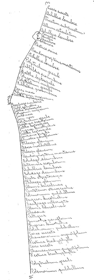
Fig. 55. Line transect running east and west in the Picea-Pinus-hylium, showing the relation of the herbaceous layer to the Carex-Catha-helium, invading along the brook; ecotones at e.
219. The location and size of line transects are determined by the purpose for which they are designed. Short transects are valuable for detail, but they can be used to advantage only where 178changes in arrangement are taking place rapidly. They are especially adapted to the study of minute alternations and to the zonation of small ponds, streams, ditches, roads, blowouts, etc. Longer transects can not furnish the same detail, on account of the amount of time necessary, but they are invaluable for the zonation and alternation of larger areas, such as the consocies, formation, and formation series. They are of particular importance for the record of zonation, since they afford a clue to the topographic symmetry of the area. The location of a transect depends upon the area to be studied, though it should always run through a portion as typical as possible. The general direction is ascertained by means of the compass, and when there is a measurable difference in elevation it is taken by the barometer or otherwise.
The points at which ecotones cross the transect are carefully indicated upon the chart. They serve as stations for simultaneous readings of physical factors, though in the majority of cases water-content readings alone will determine the reason for the ecotone. Photographs of line transects should be made while the tape is in position, in order that the superficies of the series may be as evident as possible.
The Belt Transect
220. Details. This differs from the line transect in that it is wider, and consequently affords a more accurate record of the arrangement of plants. While both give the actual facts of distribution, the line transect necessarily ignores the minor lateral deviations in position. These are brought out in a strip of some width, and the belt transect thus gives a more correct view of the variations which result from competition in an area physically homogeneous. The width of such transects depends upon the length, and the character of the vegetation. The standard width is one decimeter in herbaceous formations, and one meter in the long transects which are used in woodlands. In open vegetation, especially in the initial stages of successions, the width may often be increased to advantage, but ordinarily the amount of work necessary to run a belt transect of some length limits the width to one decimeter.
The location of a belt transect, the choice of landmarks, the determination of direction and elevation are made exactly as for the line transect. The topographic map is made in precisely the same way also, the scale used depending upon the length. Two tapes, however, are employed, and these are placed so that they mark off a strip just one decimeter wide. Every few meters, or oftener if need be, they are checked by a decimeter rule, and fixed firmly in place by quadrat stakes. The arrangement of the plants is recorded 179as for the line transect, except that the record covers a decimeter strip just as in quadrat work. Accordingly, an interval of a centimeter is left on the sheet between the successive portions of the strip, in order that the latter may be put together without confusion when the topographic map and the plant series are combined. The record should invariably start in the upper left-hand corner and read down. The map and the centimeter strip recording the plants of the transect are combined on a common scale as already indicated for the line transect.
The ecotones of zones are shown on belt transects by single cross lines, and those of consocies by parallel cross lines. In taking photographs of the transect, it is desirable to use guidons to mark these points clearly. The same device may also be used to indicate the course of the transect, when the tapes are completely hidden by the plants. Physical factor readings should always be taken, and, as before, they are best made at the intersections of the ecotones.
The Permanent Transect
221. Advantages. Both line and belt transects, after they have been recorded, should be rendered permanent, in order that they may serve to indicate the changes of a heterogeneous area from year to year in the same detailed fashion that the permanent quadrat does for homogeneous ones. For historical as well as for physical reasons, the ecotones of zones and of consocies are subject to change from year to year, and the amount and direction of this change can only be ascertained from annual records made in exactly the same spot. By means of the permanent transect alone the very origin of such areas can be followed from one stage to another of the succession. Moreover, the transect is equally valuable with the quadrat in making it possible to follow every step of the minute changes wrought by competition.
222. Details. The transect is made permanent by blazing the landmarks at either end, if these already exist, or by erecting them when it is necessary. A label stake is driven at each end, on which is painted the number and date of the transect and its length. Each stake should also indicate the exact direction in which the other lies. The position of the ecotone is indicated by smaller stakes bearing the number of the transect and the date when the ecotone was found at that point. These are left in place, and in a few years show very graphically the change in position of the zones. For the first season, permanent transects afford results of great value when recorded for each aspect, but after this an annual visit will suffice. The details of mapping, plotting, etc., are identical with those indicated above, with the addition 180that all charts and photographs must bear the number of the reading as well as that of the transect. Physical factor observations are taken as often as the charts are made, and the results noted on the back of the chart sheet for purposes of ready comparison.
The Denuded Transect
223. The denuded transect bears exactly the same relation to a permanent one as that which exists between the denuded and the permanent quadrat. While the permanent transect records the actual mutations due to changing physical factors or to competition, the denuded transect throws needed light upon the mobility and ecesis of the various species, and upon the nature of the competition between them. Denuded transects may be established wherever it seems desirable, after the strip has been properly charted and photographed. The most valuable results, however, are secured by locating each one alongside of a permanent one. The best plan is to locate and chart two permanent transects a meter apart. A single view is then made of the two. One of them is denuded together with a strip 2 decimeters on either side, resulting in a denuded transect 5 decimeters wide. In charting this during succeeding years, the entire width may well be plotted as long as the vegetation is open, but after it has again become well established, it is necessary to save time by confining one’s attention to the central decimeter strip. Photographs can be made either of the permanent and denuded transects singly, or of the two together. The latter method has certain obvious advantages. Climatic factor readings can be made for both transects in common, but all those factors which are affected by the exposure of the soil surface must be observed in each.
The Layer Transect
224. This is a modification of the line transect, by means of which the vertical relations of plants are also shown, especially the tendency to form layers which is so regular a feature of forest formations. Owing to the difficulty of charting in three planes, belt transects do not lend themselves to this purpose. Because of the greater complexity, layer transects can rarely exceed ten meters in length except in those formations where layering is little or not at all developed. The simplest method is to establish a line transect in the ordinary way, and then to record the height of each plant as its position is noted. This is done by means of a measuring stick ruled in decimeters, which can be moved from interval to interval along the tape, or better, by two such sticks connected by tapes a meter long at every five decimeters 181of the sticks. These should be two meters high for woodland, and one meter for grassland. Layer transects often run on even surfaces, but if this is not the case, the usual data for a topographic map should be taken. The final chart is constructed on the scale of 10:1, the height of each plant being indicated by a vertical line equal to .1 of the observed height. A photograph of a representative meter of the transect is taken when the measuring sticks and rods indicated above are in position. Physical factor readings, principally of light, but often also of humidity, temperature, and wind are made at the height of the various layers when these are present.
ECOTONE CHARTS
225. The contour lines of zones and consocies are of the utmost importance in recording the structure of vegetation. They do not permit such accuracy as do quadrats and transects, but this is hardly to be considered a disadvantage in view of the fact that ecotones are rarely sharply defined. In establishing the ecotones of zonation, the width and the length of the base, i. e., the area of excess or deficiency, or as much of it as is to be considered, are determined. This base may be road, ditch, pool, lake, or stream, or the peak or crest of a hill, ridge, or mountain. When the zonation is bilateral, meter tapes are run at right angles to the base, at proper intervals, and the points and the distances where the ecotones cross are noted. In the case of radial zones, the tapes are run in the four cardinal directions, and if the base be large, in the four intermediate ones also, the intersections being likewise noted. From the data thus obtained, the zones may be outlined with a fair degree of accuracy. If the series be an extensive one, it is charted to the scale of 100:1; in cases of small areas, however, the scale of 10:1 will give better results. Whenever the zones show clearly enough to warrant, a photograph is also taken. Water-content readings are of paramount importance in the interpretation of zones. Samples should be taken at all intersections, and the resulting values indicated at the corresponding points upon the chart. When the zones are broken up into alternating patches in consequence of asymmetry in the topography, the ecotones of the latter are traced in a similar fashion from the center of each as a base, the absolute position of which is ultimately determined with reference to the ecotone lines already established.
182
THE MIGRATION CIRCLE
226. Purpose. The migration circle is designed to record the invasion of species, since it operates outward from an individual or a group of plants as a center. As migration takes place to a certain degree in all directions, a circle is better adapted to the purpose than the quadrat. From the very nature of invasion, migration circles should always he permanent in order that the yearly advance may be accurately noted. Circles of this character are important aids in the study of any vegetation, except, perhaps, one that has practically become stabilized. Their great value, however, is found in succession, where it is necessary to trace the movement of new individuals away from the original invaders as centers of colonization.
227. Location and method. The size of the migration circle is largely controlled by the density of the vegetation, and in some degree by the height of the species also, since this determines the trajectory of the disseminule. In close formations, a circle of 1–, rarely of 5–meter radius can best be used, but in the more open initial stages of succession a radius of 5, 10, or, in exceptional cases such as open woodland, even 25 meters, affords the best results. The location should always be made with a plant or group of plants of the species to be studied as a center. This migration circle differs from the quadrat in that it is used to show the movement of one, rarely two or three species, and not the position of all the plants within it. The center is permanently fixed by driving a labeled stake with the number of the circle and the data. Two tapes the length of the radius are used for recording. These are provided with the usual eyelets, 5 decimeters apart, and are fastened on a peg in the top of the central stake so that they move readily. At the outer ends they are staked 5 decimeters apart by a tape of this length when the radius is 1 meter, and 1 meter when the radius is 5 or 10 meters. The record forms must be especially prepared on blank sheets about 9 inches square. The scale is 10:1 for circles of 1 meter, and 100:1 for those of 5– and 10–meter radius. In the former, concentric circles are drawn about the center at intervals of 5 decimeters, and radii are drawn to the circumference at the same interval. In the larger circles, the intervals are 1 meter. Each segment of the circle is read by means of the two tapes, and the position indicated with reference to the concentric lines and radii. When but one species is read, a tiny circle is used to denote the position of each plant. If more than one is used, the symbols are those already indicated for the quadrat. One tape is left in place and the other with the segment tape is shifted to a new position, and the resulting segment is read as before. The exact position of the base radius is fixed by a label stake, 183in order that the segments of successive years may exactly correspond. The record sheet is labeled, dated, and filed. By folding at one edge, it may be filed in the regular field book.
228. The denuded circle is established in the same way as a permanent one. The original position of the individuals of the species under consideration may be recorded or not, depending upon the use to be made of the results. The safest plan is first to read the circle in the usual way, and then to denude it. The latter should be done in such a way as to remove all the disseminules from the surface in so far as possible. It is essential also that this be done before the seeds are mature and begin to be scattered. The central plant or cluster is of course not removed. In special cases, all the plants of the species are allowed to remain to serve as centers of colonization. The successive yearly readings of the denuded area are made exactly as for a permanent circle. Permanent and denuded circles, like quadrats, should always be established near each other so that they permit of ready comparison under similar conditions.
229. Photographs of migration circles furnish the most detail when the camera is placed just behind the central group in such a way as to show its relation to the other individuals or clusters of the circle. In the denuded circle, or when the plants stand out conspicuously from the bulk of the vegetation, it is not necessary to use guidons, but in other cases the latter greatly increase the value of the picture. Factor readings are less important for migration circles than for quadrats and transects. The factors of principal importance are those that deal with migration and ecesis, i. e., wind, water-content, and soil temperatures. The former may be determined for both circles in common, but the conditions that affect ecesis must be observed separately for each.
CARTOGRAPHY
230. Value of cartographic methods. Chart, map, and photograph are records indispensable to the systematic study of vegetation. They serve not merely to preserve the facts ascertained, and to permit their ready comparison, but they also put a premium upon accurate methods, and consequently bring to light many points otherwise overlooked. For ecology, they have the value which drawings possess in taxonomy, in that they make clear at a glance what pages of description fail to indicate. They are the fundamental material of comparative phytogeography, and in all careful vegetational study their use is no longer optional but obligatory. 184Hence it is obvious that cartographic methods should be clear and simple, and that they should be uniform, so that charts and maps of widely separated formations may be directly compared without difficulty. It is not to be expected that uniform methods will come into general use immediately, but a proper appreciation of the obligation that rests upon every ecologist to make his results both easily comprehensible and usable will serve to produce this very necessary result. In the treatment that follows, as elsewhere, no attempt is made to describe the general cartographic methods used by other ecologists, notably Flahault. The methods employed by the author form a complete system, which has proved valuable, and for various reasons it alone is discussed here.
231. Standard scale. The question of the scale to which charts and maps are to be made is of primary importance. The general principle is that the ratio between area and drawing should be as small as possible. Moreover, charts and maps of the same character should always be drawn to the same scale, unless a good reason to the contrary exists. The ideal scale is 1:1, which is manifestly an impossibility. This is approached most nearly in the quadrat chart where the scale is 10:1. Charts of definite areas are made on a scale as large as possible, while maps of formations, regions, etc., are necessarily drawn upon a very small scale. General maps designed to show the distribution of species and formations, or the vegetation of continents, are usually not drawn with reference to a scale at all. While it is manifestly impossible to use the same scale for charts and maps, it is feasible and desirable that they be constructed upon scales readily convertible into each other. This is most satisfactorily accomplished by means of the decimal system, and the various type scales are 10:1, 100:1, 1000:1, etc. The first two or three scales are used for charts of quadrats, transects, and circles; the remaining ones are employed in making maps of large areas. No attempt has been made to draw an absolute line between charts and maps, but an endeavor is made to restrict the term chart to the record of the number and position of plants, while maps deal with the arrangement and location of formational areas. It is hardly necessary to point out the reasons why all charts and maps should be based upon the decimal system of scales. Experience will furnish the very best of arguments.
232. Color scheme. The first requisite for the graphic representation of formations, regions, etc., is that each class of formations be invariably indicated by the same color. It is also necessary that the colors and shades be easily distinguishable, and it is at least desirable that they be referred to the different classes in some consistent sequence. Uniformity in all these 185points is greatly to be desired at the hands of all ecologists. Here, as in the case of the standard scale, uniformity will be found the more desirable the more impossible it is made by ignoring it. In the use of color to represent regions and provinces, on maps too small to indicate formations, the color of each division is represented by the color of its dominant formation; thus the prairie province is colored ochroleucus on account of the color used to represent prairie formations, the boreal-subalpine zone atrovirens on account of the typical coniferous forests, etc. No endeavor has been made to take account of the various types of formations, e. g., the different coniferous forests, as this is a problem to be worked out for more local maps in various shades of dark green, etc. The following color scheme which has been based upon the points made above is proposed as a satisfactory solution of the problem. The color standard used is that of Saccardo’s Chromotaxia.
I.
Hydrophytic Formations: blue 1. Marine: cyaneus 2. Brackish: ardesiacus 3. Freshwater: caeruleus 4. Swamps and marshes: caesius
II.
Mesophytic Formations A. Forest formations: green 1. Coniferous forests: atrovirens 2. Broadleaved evergreen forests: viridis 3. Deciduous forests: flavovirens B. Grassland formations: yellow 1. Meadows: melleus 2. Prairies: ochroleucus C. Culture and waste formations: red 1. Fields: ruber 2. Groves and orchards: atropurpureus 3. Wastes: purpureus
III.
Xerophytic Formations: brown 1. Deserts: isabellinus 2. Plains and steppes: avellaneus 3. Saline formations: umbrinus 4. Arctic-alpine formations: testaceus
233. Formation and vegetation maps are detailed maps of a single formation or a series of them, showing the formational limits, and when the scale is not too small, the ecotones of zones and consocies. In the cases 186where the topography is level, as sometimes happens in mapping single formations, the chain and pedometer must be used to ascertain the size of the different areas. Indeed in all mapping of vegetation, the methods of surveying are directly applicable. Over large areas, however, it is not necessary that limits be drawn with mathematical accuracy, and for the purposes of the ecologist, the plane table and camera are satisfactory substitutes for the surveyor’s transit, at least in the present aspect of the subject. When the formation or group of formations is commanded by an elevation of some height, the latter is used as a base. A plane table is established upon it and the topographical and vegetational features are recorded in the usual way. This map is usually supplemented by a series of views from the same base. Indeed it has come to be recognized that a complete series of photographs of this kind give a more valuable record than the plane table, and that the construction of an accurate map from them is an easy matter. Since the camera saves much time and energy also, it is used almost exclusively to furnish the data for map making. In hilly, and especially in mountainous regions, the photographic method is indispensable. Its application is extremely simple. A central hill or mountain is selected, and from it a series of views is taken so that the edge of one exactly meets the edge of the other. This is an extremely important matter, and demands much nicety of judgment. The camera is kept in the same spot, and after each exposure it is turned as the operator looks through it until a landmark at one edge just passes from view at the other. As soon as the new position is determined, the tripod screw is turned to hold the box firmly in position. In case of a slight jar, the exact position should again be obtained. If the series is accurately made, the resulting prints will give a complete panoramic view of the region, without overlap or omission. For this purpose, a 6½ × 8½ camera is desirable, since the topographic and vegetational features are larger and stand out more distinctly. A large camera requires fewer changes of position, and hence saves time and reduces the chance of error. A 4 × 5 camera serves the purpose sufficiently well, though it requires a little more care in operation on account of the greater number of exposures necessary. This may be avoided in some degree by the use of a wide-angle lens if the depth of the area is not too great. Whatever camera may be used, a telephoto lens is a very desirable adjunct, since it enables one to choose between three different sizes of the view without changing the position of the camera. To avoid possible confusion, the exposures are always made from right to left, and the plates are used in the numerical order of their holders. For the same reason the landmarks are described and numbered in their proper order. The prints obtained are mounted on a card in sequence. The view map may be preserved in this form, or it may be reduced or 187enlarged by making a copy to the size desired. Outline maps of topography may be traced from the resulting negative, and the formations filled in by means of the proper colors. The most satisfactory method, however, is to have the original views or the copy printed “light” and to color the formations just as they appear there, with all the wealth of topographic and vegetational detail. If a detailed topographic map alone is desired, this is traced directly from the large copy.
234. Continental maps. A method of determining the general outlines of regions, provinces, and vegetational zones as a preliminary to their detailed study has been used successfully for several years.[22] This is based upon provincial and continental maps on which are traced the geographical areas of the species of genera typical of the various formations. Detail topographic maps of the prairie province and the North American continent have been used for this purpose. A number of the facies of extensive and representative formations of the different portions of the continent are selected and grouped according to genera. One map is devoted to each genus, unless the number of species is large. In this case a number of maps are used, since the limits are apt to become confused. The range of each species is determined from all the reliable sources, and a corresponding line is drawn upon the map to delimit its geographical area. The limits of the area of each species are drawn in a different color, and the name of the species printed in the same color in the legend. Although this work has as yet been done only for the trees of North America, and for the grasses and principal species of the prairie province, it promises to constitute a final method for the limitation of vegetational divisions. It is clear that if the original data concerning ranges are accurate, the increasing study of formations will do little more than rectify the detailed course of the limiting line, since in most cases facies and formations coincide in distribution. The limiting line or ecotone of a zone or province is a composite obtained from the limits of certain representative facies and principal species, and checked by the limits of species typical of the contiguous vegetations. Thus, the boreal-subalpine zone is clearly outlined by combining the limits of Populus tremuloides, Larix americana, Pinus banksiana, Abies balsamea, Picea mariana, Picea canadensis, and Betula papyracea, and checking the results by the areal limits of the hardwoods and grasses to the southward.
188
PHOTOGRAPHY
235. The camera is an indispensable instrument for the ecologist. Although it has too often been employed to give an air of thoroughness to work of no ecological value, it is as important for recording the structure of vegetation as the automatic instrument is for the study of the habitat. No ecologist is equipped for systematic field investigation until he is provided with a good camera and has become skilful in its use. For this reason, it is felt that a few hints concerning photographic methods and their application in ecology may not be out of place. No written advice can take the place of experience, but certain elementary suggestions and cautions will greatly shorten the apprenticeship of one who does not have the good fortune to be taught by a professional photographer. To the student of ecology, the camera is not a toy. It must be understood and operated with as much thoroughness as any other instrument, and when this is done, the results will be equally certain and desirable.
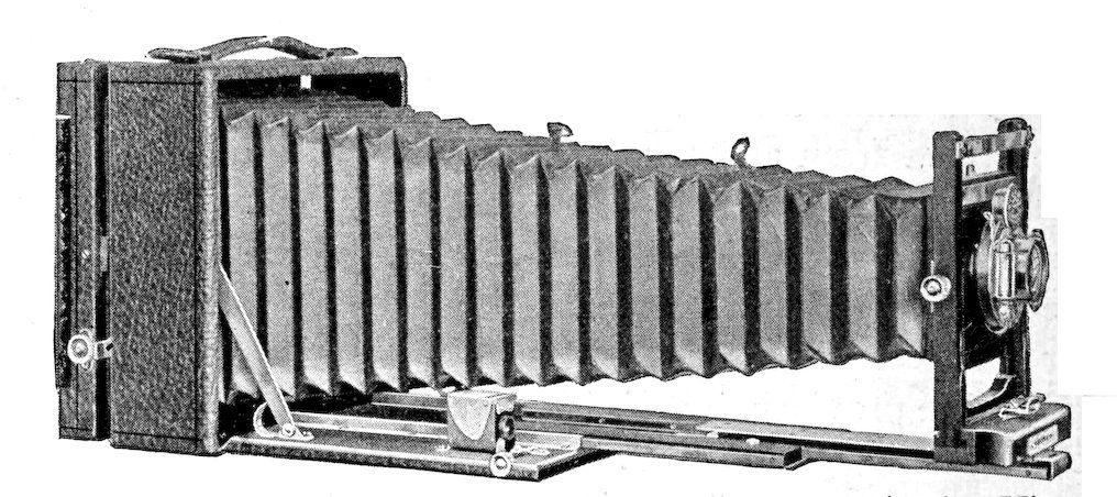
Fig. 56. 4 × 5 long focus “Korona” camera (series V).
189
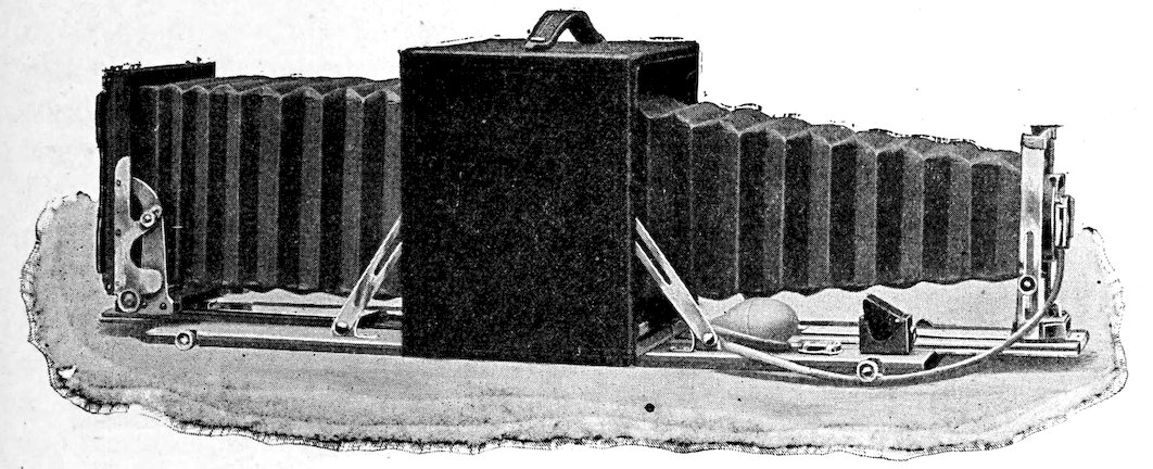
Fig. 57. 5 × 7 long focus “Premo” camera.
236. The camera and its accessories. Although two cameras are desirable whenever it is possible to obtain them, a single one will meet all the requirements of field work. This should be 4 × 5 inches in size, since it is much more convenient and will do all the work that a larger camera can. In the comparatively few cases in which larger views are needed, the 4 × 5 negatives can be readily enlarged. The smaller instrument is less expensive in operation because of the cheapness of the plates, and it gives a negative of the proper size for lantern slides and for reproduction. A 6½ × 8½ camera is valuable in special cases, such as making a series of photographs for maps. In the writer’s own experience, the 6½ × 8½ camera, although used exclusively at first, has been almost completely supplanted by the 4 × 5. The best field camera is of the folding type with a good stout box. It must be what is known technically as a long focus instrument, which enables small objects to be taken natural size and permits the use of a telephoto lens. It should be provided with a swing and also a reversible back by which the position of the plates can be changed instantly. The lens must be of the telephoto pattern, which makes it possible to use the front or back lens either alone or in combination. The chief advantage of this is that the image, when distant, may be made of three different sizes without changing the position of the camera. Generally speaking, the high-priced rapid lenses are the best, since it is exceptional to get the desired length of exposure in vegetation, on account of the ease with which the plants move in the wind. Before buying such a lens it is desirable to test its rapidity and depth of focus, since it is not necessarily better than some of the lenses furnished with good cameras. The lens should be provided with an iris diaphragm capable of being stopped down to 128 or 256. The shutters furnished with the ordinary lenses are satisfactory, since “snap-shots,” i. e., instantaneous exposures, are practically never possible for plants. The automatic shutter of the “Premo” camera is an especially convenient form. All shutters should be carefully tested before using to determine the exact time value of the exposures indicated. It is not uncommon for the exposure at 1 second, or at other points, to have a value quite different from the one indicated. When this is the case, it is evident that it can not be known too soon. The camera should have at least a half-dozen double plate-holders. These are numbered consecutively so that the figure uppermost when the holder is in the camera will indicate the number of the plate exposed. A carrying case is desirable on a long trip when all the plate-holders must be taken, but ordinarily it is a disadvantage, since the camera box will carry two or three holders. The camera cloth should be as small and light as possible, and at the same time opaque. The most satisfactory one for the 190field is the rubber cloth. The tripod should be a happy combination of lightness and stability, a condition more nearly reached by the aluminum tripod than by any other. It should have not less than three joints in order to facilitate the use of the long focus upon objects near the ground.
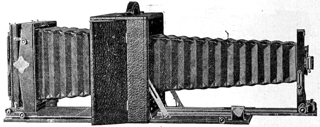
Fig. 58. 5 × 7 “Korona” Royal camera.
237. Choice of a camera. There is not a great deal of choice between the moderate-priced cameras of the various makers. A field camera is restricted to certain special uses, and hence is more serviceable when attachments useful only in portraiture or instantaneous work are absent. Even the ray filter, which has some value in the indoor photography of flowers, is useless in the field on account of the long exposure required. From considerable experience, “Premo” and “Korona” cameras have been found to be very satisfactory instruments. Doubtless the same statement would be found true of all the standard makes, but they have not been used by the writer. “Premo” cameras are made by the Rochester Optical Co., Rochester, N. Y., and “Korona” cameras by the Gundlach-Manhattan Optical Co., Rochester, N. Y. When two or more cameras are used, the best results can be obtained if they are of the same make, since the details of operation are then the same. The reduced liability of making a blunder is often offset by the fact that a different pattern will permit of a wider range of use. Any standard brand of plates will produce good negatives when skilfully used; at least, this has been proved in the case of the Cramer, Hammer, Seed, and Stanley brands. Every professional photographer has his favorite brand of plate, but the ecologist will do well to give the various kinds a thorough trial, and then to invariably use the one which gives him the best results. Thus, while it seems to be less popular with the profession than the others mentioned, the writer has obtained at least as satisfactory results 191with the Stanley plate as with the others, and consequently now uses it exclusively, since it is cheaper. The one important point is to make a final choice only after personal experience, and then to always use plates of the same brand, and preferably of the same rate of speed.
238. The use of the camera. To the ecologist, objects to be photographed fall into two categories, viz., those that move, and those that do not move. For practical purposes, areas sufficiently distant to render the movement imperceptible belong to the latter, as well as those, such as rock lichens, many fungi, etc., which can not be stirred by ordinary winds. The treatment accorded the two is essentially different. A fundamental rule of ecological photography is that detail must receive the first emphasis. The ecological view should be a picture as well as a map, however, but when one must be sacrificed, artistic effect must yield to clearness, and accuracy, i. e., technically speaking, contrast must give way to detail. Leaving apart the necessity of securing a sharp focus, which holds for all work, detail or definition depends directly upon the aperture of the diaphragm. Detail is increased by decreasing the size of the aperture. This in turn increases the length of time necessary for a proper exposure, and consequently the danger that the plant will be moved in the midst of the exposure. When the movement is negligible, the invariable rule should be to reduce the aperture to its smallest size, and to expose for a corresponding time. In all cases where the plants are close enough to show even a slight blurring on account of the action of the wind, the time of exposure must be reduced, in the hope that a short period of quiet will suffice for it. This reduction in time must be compensated by increasing the aperture of the diaphragm, and hence the amount of light which strikes the plate. The proper balance between the two is a matter of considerable nicety. It depends much upon the vagaries of the wind, and can readily be determined only after considerable experience. Although regions naturally differ somewhat in the nature of their winds, much experience in prairie and mountain regions warrants the primary rule that views of vegetation and plants subject to movement are not to be attempted on windy or cloudy days when it can possibly be avoided. Even on reconnaissance, a poor picture is no better than none at all, while in resident work a time will come sooner or later which will permit the making of a view satisfactory in all respects. There may be occasional instances when one is rewarded for keeping the camera trained on a particular spot for hours, and for wasting several plates in the hope that still moments will prove to be of the requisite duration. As a regular procedure, however, this has nothing to commend it.
Various methods have been tried to reduce or eliminate the trouble caused by the wind. Canvas screens have been used for this purpose with some 192benefit. When the picture is worth the trouble, a tent may be erected to afford a very efficient protection. This is too prodigal of time and energy, however, to be practicable under the usual conditions. Flashlight exposures on still nights are sometimes feasible, but the disadvantages connected with them are too great to bring them into general use. The best procedure is to bide one’s time, and to take quadrats, transects, and other detail areas, as well as many plant groups, at a time that promises to be most favorable. Single plants can often be moved in the field so that they are protected from the wind, or so that they are more strongly lighted. Slender, or feathery plants are usually very difficult to handle out of doors. The best plan is to photograph them in a room that is well and evenly lighted, or, best of all, in a stable, roomy tent.
239. The sequence of details. No photographer ever escapes blunders entirely. At the outset of his work, the ecologist must fully realize this, and accordingly plan a method of operating the camera which will reduce the chance of mistake to a minimum. The usual blunders which every one makes sooner or later, such as making two exposures on one plate, drawing the slide before closing the shutter, allowing the light to strike the plate through the slit in the holder, etc., can be all but absolutely avoided by a fixed order of doing things. This order will naturally not be the same for different persons; it is necessary merely that each have his own invariable sequence. The following one will serve as an illustration. As a preliminary, the plate-holders are filled, after having been carefully dusted, and the slides are uniformly replaced with the black edge inward. It is a wise precaution to again see that all the slides are in this position before leaving the dark room. This will ensure that a black edge outward always means that the plate has been exposed. The tripod is first set up and placed in what seems about the proper position. The camera is next attached to it, and the front and back opened. The bellows is pulled out, a short distance for views, and a longer one for detail pictures, and fastened. It is necessary to move the diaphragm index to the largest aperture and to open the shutter at “time.” The next steps are to orient the view or object, and to bring it into sharp focus upon the ground glass. The first is accomplished by moving the entire instrument, changing the position of the tripod legs, swinging the camera upon the tripod, or by raising or lowering the lens front. It is often desirable also to change the position of the object on the plate by use of the reversible back. In views with much distance, the foreground is brought into sharp focus. In close views, especially of quadrats, the swing is used to increase the distance for the foreground, and the focus is made upon the center. After focusing, the shutter is closed, the indicator set at the time 193desired, and the diaphragm “stopped down” as far as possible. Plate-holder 1 is slipped into place, care being taken not to move the camera by a sudden jar. The camera cloth is dropped above the holder and allowed to hang down over the slide end. The slide is drawn and put on top of the instrument, the black edge always up. The exposure is made and the slide replaced with the black edge outward. This point should receive the most critical attention, as a blunder here will often cause the loss of two negatives. The plate-holder is returned to the receptacle, or merely placed in the back of the camera, which is then closed. The number of the plate, the name of the view or object, the condition of the light, the length of exposure, and the aperture of the diaphragm, as well as the date, are recorded in a notebook for this purpose. The shutter is then opened at “time,” the diaphragm thrown wide open, and the front of the camera closed. When distances are short, the camera is often carried upon the tripod. As a rule, however, it is usually removed, and the tripod folded. In making subsequent pictures, the plates should always be used in their numerical order.
240. The time of exposure is obviously the most critical task in the manipulation of a camera. The time necessary for a proper exposure varies with the season, the hour, the condition of the sky, the light intensity of the formation, the color and size of the area to be photographed, and, finally, of course, with the aperture of the diaphragm. Fortunately for the ecologist, the variation in light intensity during the season, and even during the greater part of the day, is not great, and can ordinarily be ignored. The beginner will make the most progress by determining the exposure demanded by his instrument for taking a general view in full sunlight and with the smallest stop of the diaphragm. In standard cameras with lenses of ordinary rapidity, this is usually about one second. This will serve as a basis from which all other exposures may be reckoned until one has worked through a wide range of conditions and can recall just what time each view requires. On completely cloudy days the time required is five to ten times that necessary on a clear day; filmy clouds and haze necessitate an exposure of two or three seconds. The more open forest formations demand an exposure of about five to ten seconds on a sunny day, while the deeper ones require two or three times as long. A close view requires more time than a distant one, since the light-reflecting surface is much smaller. Quadrats require two or three seconds, and individual groups frequently take a longer time. The color of the vegetation plays an important part also: a dark green spruce forest requires twice as long an exposure as the aspen forest, and a grassland quadrat takes more time than one located in a gravel slide. In this connection, it is hardly necessary to point out that the lighted side of 194objects should always be taken, never the shaded one. The exposures indicated above are based upon the smallest stop. The reasons for using this whenever possible have already been given. When a larger stop is necessary, the exposure is decreased to correspond; for example, a quadrat that takes three to four seconds at 256 can be taken at 64 in one second. As a rule, the sun should not be in front of the camera, but, when necessary, views can be made in this position if the sun is prevented from shining directly into the lens.
241. Developing is as important as exposing. Indeed, it may well be considered more important, since a properly exposed plate may be spoiled in developing, while an under-exposure or over-exposure may be saved. Owing to the ease with which plants move in the wind, the ecologist is obliged to reconcile himself to many under-exposures, which can be converted into good negatives only by skilful developing. Every base station should have a good dark room, equipped with running water when possible, a good ruby lantern, and the proper trays and chemicals. Prepared developing solutions are alluring because of their convenience, but after an extended trial of several kinds, the writer has reached the conviction that pyrogallic acid, or “pyro,” is by far the most satisfactory in working with vegetation. Of almost innumerable formulae, the following gives excellent satisfaction and is convenient to use.
I. II.
500 cc. water 500 cc. water
30 grams sodium sulphite 5 grams pyrogallic acid
30 grams sodium carbonate
For developing, equal parts of I and II are mixed, and a few drops of a 10 per cent solution of potassium bromide added, unless there is reason to suspect that the plate has been seriously underexposed. The fixing bath is a concentrated solution of sodium hyposulphite, “hypo,” to which a few drops of acetic acid are added. It should be replaced every week or two, depending upon how much it is used. A tray of water is kept at hand for bringing out the detail in underexposed negatives, and a second tray is used for washing. The “pyro” and the bromide solution should always be within reach, the former for accelerating, and the latter for retarding the development of unsatisfactory plates.
The image will begin to show on a properly exposed plate within one to three minutes after it has been put in the developer. If the image appears almost instantly, and then recedes quickly, the plate is badly overexposed, 195and should be thrown away. In case it “comes up” less quickly, indicating that it is not greatly overexposed, it can be saved by the addition of more bromide. When the image does not show till the end of five to ten minutes, the plate has been underexposed. It is then necessary to add more “pyro,” taking care not to pour it on the plate, and, after the image appears with its striking contrast, to leave the plate in water until as much detail as possible is brought out in the shadows. In the case of a normal exposure, when greater detail is desired, the negative is left for some time in water, and when contrast is sought more “pyro” is used. Negatives with unusual detail lack “snap”; they are “flat,” and fail to make artistic pictures. Contrast, on the other hand, often obscures detail, and the best results can only be obtained by a happy combination of the two. The most important maxim in developing is that the process shall be continued until the image has become indistinct. The universal tendency of the beginner is to remove the negative the moment the outlines grow dimmer, and the result is a thin, lifeless negative. It is almost impossible to develop too far, if the image is not allowed to disappear. Negatives of this sort are “thick,” and though they print more slowly, produce brilliant pictures. A large quantity of the developing solution is used with single plates in small trays, and is allowed to act without rocking the tray. Much time is saved, however, by developing several plates together, and to avoid using a large quantity of the solution, the tray is gently rocked from time to time. This movement is particularly necessary at the beginning, in order that the plates may be covered evenly, and at once. Fifty cubic centimeters of the solution will develop three or four 6½ × 8½ plates, and twice as many 4 × 5’s. After the developer has once been used, it is kept for several days to restrain overexposed plates. As soon as the plate is developed, it is rinsed in water, and placed in the fixing fluid, until the white opaqueness is entirely removed. The “hypo” is then washed out by immersing the negatives for one to two hours in running water. If the latter can not be secured, the water in which they are placed should be changed frequently. The negatives are then air-dried within doors, in a place free from dust. Finally, they are filed away in negative envelopes, each bearing the name and number of the negative, and preferably also, the time and other exposure data.
242. Finishing. On account of the time demanded by other field tasks, it has not been found desirable to make and finish prints in the field. This, with the making of lantern slides, enlargements, etc., may well be turned over to a professional photographer. It is the custom to make a proof of each negative to meet the casual needs that arise in the field. For this 196purpose, solio “seconds” are used, since they are both cheap and satisfactory. When an urgent demand for a finished print does arise, it is met by using “velox” paper, which can be exposed in the dark room, and then developed and fixed exactly like a plate. Two standard papers for views are “solio” and “platina.” The former gives brown tones, and is used for contrast and brilliancy, hence it is especially good for printing from negatives that have too much detail and too little contrast. “Platina,” on the contrary, yields soft gray tones, and softens contrasts.
FORMATION AND SUCCESSION HERBARIA
243. Concept and purpose. A formation herbarium is a collection of exsiccati, in which the species are arranged with respect to their position in the formation, instead of being grouped in genera and families. Its primary purpose is to furnish a record of the constitution and the structure of a formation or a series of formations. At the same time, it affords the basal material for developing the subject of comparative phytogeography. It is impossible for one ecologist to visit many remote regions, to say nothing of spending a period sufficient for obtaining even a fair knowledge of the vegetation. He can at the best acquire an acquaintance with but few regions at first hand. In consequence, a method that brings a vegetation to him, with its structure carefully wrought out by years of study, is of the highest value. Time, as well as distance, sets a narrow limit to the number of formations which one man can investigate critically in a lifetime. It is no longer possible for a botanist to explore vast regions, and to bring back results which have anything more than a very general value. This fact, far from restricting the comparative study of vegetation, will serve to make it more accurate and systematic. The exact results of numerous resident investigators, expressed in formation herbaria, with the proper series of quadrat maps and photographs, will be worked over by men who are themselves specially acquainted with a particular vegetation. Comparisons will be founded upon a definite basis, and the relationship of various vegetations can then be expressed in precise rather than general terms. It is hardly too sweeping to assert that accurate work in the field of comparative phytogeography can be done only in this fashion. The value of formation herbaria in class work is evident. On account of the limitations of time and distance, classes can touch but few formations, and these at every time except the growing period. For these reasons, an accurate and complete formational record that can be consulted or studied at any time is almost indispensable to class study in the development and structure of formations.
197244. Details of collecting. Formational collections, unlike the ordinary sets of exsiccati, can not be made upon the first visit to a region, or by a single journey through it. The determination of formation limits, and of developmental stages, of aspects, layers, abundance, etc., must necessarily precede, a work which alone takes several years. Moreover, collecting itself requires more than one year in a region containing numerous formations. This is exemplified by the Herbaria Formationum Coloradensium.[23] The preliminary study for this was made from 1896–1899, the collecting was done chiefly in 1900 and 1901, while additional numbers were added in 1902–3. For the purposes of the formation herbarium, specimens should be collected and pressed in such fashion as to show all the ecological features possible. Plants must be collected both in flower and in fruit, with the underground parts as perfect as may be. Seedlings and rosettes should be included whenever present. In pressing, one or two leaves should be arranged with the lower side uppermost to admit of the ready comparison of both surfaces. Opened flowers are valuable for flower biology, while seeds and fruits are desirable for showing migration contrivances. The ferns, mosses, and lichens of the formation should be fully represented, together with the more important fungi and algae. The number of photographs taken for each herbarium should be limited only by considerations of time and expense. The ideal series consists of a general view of each formation, showing its physiographic setting, nearer views of each of its aspects, detail views of its consocies, societies, and layers, and flower portraits of all the constituent species. Such a series can only be obtained by residence through a long term of years, and in most cases general and aspect views, with portraits of the facies and a few of the striking principal species, must suffice. Quadrat and transect charts, together with formational maps, are extremely desirable, and, indeed, all but indispensable.
245. Arrangement. The arrangement of species within each formation herbarium is based upon the structure of the vegetation. The primary groupings are made with reference to time of appearance and abundance; when definite zones, associations, or layers are present, they must likewise be taken into account. In the Colorado collection, the first division is into three aspects based upon the period of flowering (aspectus vernalis, aestivalis, autumnalis). Within each aspect, the species are arranged with respect to abundance in the groups, facies, principal species, and secondary species. Each group is placed in an ordinary manila cover, which bears a printed label indicating the aspect and the group. The species labels give, 198in addition to the name, date, and place of collection, the phyad or vegetation form, the geographical area, the rank of the species, the aspect, and the formation. To these may well be added data concerning migration contrivances, seed production, pollination, period of flowering, etc. The photographs are mounted on the usual herbarium sheets, and placed in the proper order in the various groups, and a similar disposition is made of quadrat and transect charts, and such physical factor summaries as seem desirable.
246. Succession herbaria. The arrangement of formation herbaria may follow the classification of formations with respect to character, region, or development. The first is the most convenient for purposes of instruction, and has distinct advantages in permitting a close comparison of the vegetation of different habitats. The second basis, which is the one used in the Herbaria Formationum Coloradensium, is peculiarly adapted to mountain vegetation in which the zones are usually very distinct. The arrangement of herbaria in a developmental series, however, is the most logical and the most illuminating, since the structure of the ultimate formations is not only made plain, but the stages in their development are also laid bare. Such succession herbaria are the natural outgrowth of formational ones. Indeed, the latter should be made merely the starting point for these in all regions where the causes which bring about successions are active. Where weathering is still an important factor, as in mountains, the initial and intermediate formations which lead to the final grassland or forest are often in evidence. After a formation herbarium of each stage has been made in the way indicated, a succession herbarium is obtained merely by arranging the various herbaria in the sequence of the developmental stages. Thus, in the Colorado collection, the subalpine formations are arranged according to altitude in the following series: (1) the pine formation, (2) the gravel slide formation, (3) the half gravel slide formation, (4) the aspen formation, (5) the balsam-spruce formation, (6) the spruce-pine formation, (7) the meadow thicket formation, (8) the brook bank formation. Of these, five belong to the same succession, and it is possible to indicate the development of the spruce-pine forest by arranging these five formations in their proper order in a succession herbarium, as follows: (1) the gravel slide formation, (2) the half gravel slide formation, (3) the pine formation, (4) the balsam-spruce formation, (5) the spruce-pine formation.
199
Development and Structure
247. Vegetation an organism. The plant formation is an organic unit. It exhibits activities or changes which result in development, structure, and reproduction. These changes are progressive, or periodic, and, in some degree, rhythmic, and there can be no objection to regarding them as functions of vegetation. According to this point of view, the formation is a complex organism, which possesses functions and structure, and passes through a cycle of development similar to that of the plant. This concept may seem strange at first, owing to the fact that the common understanding of function and structure is based upon the individual plant alone. Since the formation, like the plant, is subject to changes caused by the habitat, and since these changes are recorded in its structure, it is evident that the terms, function and structure, are as applicable to the one as to the other. It is merely necessary to bear in mind that the functions of plants and of formations are absolutely different activities, which have no more in common than do the two structures, leaf and zone.
248. Vegetation essentially dynamic. As an organism, the formation is undergoing constant change. Constructive or destructive forces are necessarily at work; the former, as in the plant, predominate until maturity, when the latter prevail. Consequently, it no longer seems fruitful to classify the phenomena of vegetation as dynamic or static. The emphasis which has been placed upon dynamic aspects of vegetation has served a useful purpose by calling attention to the development of the latter. Although it is a quarter of a century since Hult, and more than a half century since Steenstrup, by far the greater number of ecological studies still ignore the problem of development. This condition, however, can be remedied more easily by insisting upon an exact understanding of the nature of the formation than in any other way. It is entirely superfluous to speak of dynamic and static effects in the plant, and the use of these terms with reference to the formation becomes equally unnecessary as soon as the latter is looked upon as an organism. The proper investigation of a formation can no more overlook development than structure, so closely are the two interwoven. Future research must rest squarely upon this fact.