WILLIAM GILBERT (continued 5)
Silvanus P. (Silvanus Phillips) Thompson translation
CHAP. VII.
Why the variation from that lateral cause is not greater than has hitherto been observed, having been rarely seen to reach two points of the mariners' compass, except near the pole.
he earth, by reason of lateral eminences of the stronger globe, diverts iron and loadstone by some degrees from the true pole, or true meridian. As, for example, with us English at London it varies eleven degrees and ⅓: in some other places the variation is a little greater, but in no other region is the end of the iron ever moved aside very much more from the meridian. For as the iron is always directed by the true verticity of the earth, so the polar nature of the continent land (just as of the whole terrene globe) acts toward the poles: and even if that mass divert magnetick bodies from the meridian, yet the verticity of those lands (as also of the whole earth) controls and disposes them so that they do not turn toward the East by any greater arc. But it is not easy to determine by any general method how great the arc of variation is in all places, and how many degrees and minutes it subtends on the horizon, since it becomes greater or less from diverse causes. For both the strength of true verticity of the place and of the elevated regions, as well as their distances from the given place and from the poles of the world, must be considered and compared; which indeed cannot be done exactly: nevertheless by our method the variation becomes so known that no grave error will perturb the course at sea. If the positions of the lands were uniform and straight along meridians, and not defective and rugged, the variations near lands would be simple; such as appear in the following figure.
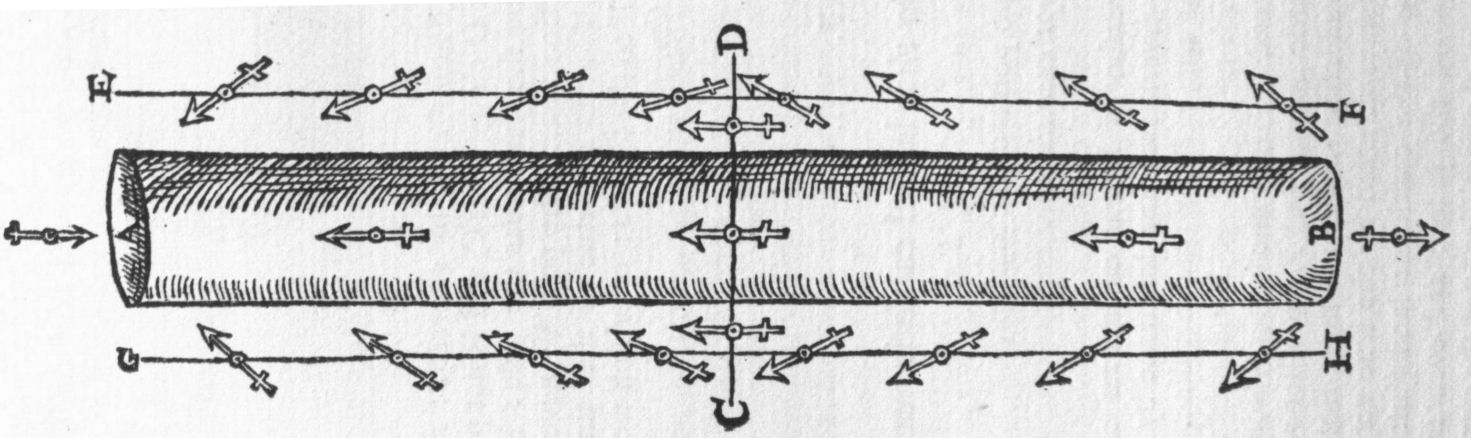
This is demonstrated by a long loadstone the poles of which are in the ends A B; let C D be the middle line and the æquinoctial, and let G H and E F (the lines) be for meridians on which versoria are disposed, the variations of which are greater at a greater distance from the æquator. But the inequalities of the maritime parts of the habitable earth, the enormous promontories, the very wide gulfs, the mountainous and more elevated regions, render the variations more unequal, or sudden, or more obscure; and, moreover, less certain and more inconstant in the higher latitude.
CHAP. VIII.
On the construction of the common mariners' compass[225], and on the diversity of the compasses of different nations.
n a round[226] hollow wooden bowl, all the upper part of which is closed with glass, a versorium is placed upon a rather long pin which is fixed in the middle. The covering prevents the wind, and the motion of air from any external cause. Through the glass everything within can be discerned. The versorium is circular, consisting of some light material (as card), to the under part of which the magnetick pieces of iron are attached. On the upper part 32 spaces (which are commonly called points) are assigned to the same number of mathematical intervals in the horizon or winds which are distinguished by certain marks and by a lily indicating the north. The bowl is suspended in the plane of the horizon in æquilibrium in a brass ring which also is itself suspended transversely in another ring within a box sufficiently wide with a leaden weight attached; hence it conforms to the plane of the horizon even though the ship be tossed to and fro by the waves. The iron works are either a pair with their ends united, or else a single one of a nearly oval shape with projecting ends, which does its work more certainly and more quickly. This is to be fitted to the cardboard circle so that the centre of the circle may be in the middle of the magnetick iron. But inasmuch as variation arises horizontally from the point of the meridian which cuts the horizon at right angles, therefore on account of the variation the makers in different regions and cities mark out the mariners' compass in different ways, and also attach in different ways the magnetick needles to the cardboard circle on which are placed the 32 divisions or points. Hence there are commonly in Europe 4 different constructions and forms. First that of the States on the Mediterranean Sea, Sicily, Genoa, and the Republick of Venice. In all these the needles are attached under the rose or lily on the cardboard versorium, so that (where there is no variation) they are directed to the true north and south points. Wherefore the north part marked with the lily always shows exactly the point of variation when the apex itself of the lily on the movable circle, together with the ends of the magnetick wires attached below, rests at the point of variation. Yet another is that of Dantzig, and throughout the Baltic Sea, and the Belgian provinces; in which the iron works fixed below the circle diverge from the lily ¼ of a rumbe to the east. For navigation to Russia the divergency is ⅔. But the compasses which are made at Seville, Lisbon, Rochelle, Bordeaux, Rouen, and throughout all England have an interval of ½ a rumbe. From those differences most serious errors have arisen in navigation, and in the marine science. For as soon as the bearings of maritime places (such as promontories, havens, islands) have been first found by the aid of the mariners' compass, and the times of sea-tide or high water determined from the position of the moon over this or that point (as they say) of the compass, it must be further inquired in what region or according to the custom of what region that compass was made by which the bearings of those places and the times of the sea-tides were first observed and discovered. For one who should use the British compass and should follow the directions of the marine charts of the Mediterranean Sea would necessarily wander very much out of the straight course. So also he that should use the Italian compass in the British, German, or Baltic Sea, together with marine charts that are made use of in those parts, will often stray from the right way. These different constructions have been made on account of the dissimilar variations, so that they might avoid somewhat serious errors in those parts of the world. But Pedro Nuñez seeks the meridian by the mariners' compass, or versorium (which the Spanish call the needle), without taking account of the variation: and he adduces many geometrical demonstrations which (because of his slight use and experience in matters magnetical) rest on utterly vicious foundations. In the same manner Pedro de Medina, since he did not admit variation, has disfigured his Arte de Navegar with many errors.
CHAP. IX.
Whether the terrestrial longitude can be found from the variation.
rateful would be this work to seamen, and would bring the greatest advance to Geography. But B. Porta in chap. 38 of book 7 is mocked by a vain hope and fruitless opinion. For when he supposes that the magnetick needle would follow order and proportion in moving along meridians, so that "the neerer it is to the east, the more it will decline from the Meridian line, toward the east; and the neerer it comes to the west, the point of the needle will decline the more to the west" (which is totally untrue), he thinks that he has discovered a true index of longitude. But he is mistaken. Nevertheless, admitting and assuming these things (as though they were perfectly true), he makes a large compass indicating degrees and minutes, by which these proportional changes of the versorium might be observed. But those very principles are false, and ill conceived, and very ill considered; for the versorium does not turn more to the east because a journey is made toward the east: and although the variation in the more westerly parts of Europe and the adjoining ocean is to the east and beyond the Azores is changed a little to the west, yet the variation is, in various ways, always uncertain, both on account of longitude and of latitude, and because of the approach toward extensive tracts of land, and also because of the form of the dominant terrestrial eminences; nor does it, as we have before demonstrated, follow the rule of any particular meridian. It is with the same vanity also that Livio Sanuto so greatly torments himself and his readers. As for the fact that the crowd of philosophizers and sailors suppose that the meridian passing through the Azores marks the limits of variation, so that on the other and opposite side of that meridian a magnetick body necessarily respects the poles exactly, which is also the opinion of Joannes Baptista Benedictus and of many other writers on navigation, it is by no means true. Stevinus (on the authority of Hugo Grotius) in his Havenfinding Art distinguishes the variation according to the meridians: "It may be seene in the Table of variations, that in Coruo the Magneticall needle pointeth due North: but after that, the more a man shal goe towards the East, so much the more also shall he see the needle varie towards the East [ἀνατολίζειν], till he come one mile to the Eastward from Plimouth, where the variation comming to the greatest is 13 degr. 24 min. From hence the Northeasting [Anatolismus] beginneth to decrease, til you come to Helmshude (which place is Westward from the North Cape of Finmark) where againe the needle pointeth due North. Now the longitude from Coruo to Helmshude is 60 degr. Which things being well weighed, it appeareth that the greatest variation [Chalyboclysis] 13 degr. 24 minutes at Plimmouth (the longitude whereof is 30 degr.) is in the midst betweene the places where the needle pointeth due North." But although this is in some part true in these places, yet it is by no means true that along the whole of the meridian of the island of Corvo the versorium looks truly to the north; nor on the meridian of Plymouth is the variation in other places 13 deg. 24 min.—nor again in other parts of the meridian of Helmshuda does it point to the true pole. For on the meridian passing through Plymouth in Latitude 60 degrees the North-easterly variation is greater: in Latitude 40 deg. much less; in Latitude 20 deg. very small indeed. On the meridian of Corvo, although there is no variation near the island, yet in Latitude 55 degrees the variation is about ½ a rumbe to the North-west; in Latitude 20 deg. the versorium inclines ¼ of a rumbe toward the East. Consequently the limits of variation are not conveniently determined by means of great circles and meridians, and much less are the ratios of the increment or decrement toward any part of the heavens properly investigated by them. Wherefore the rules of the abatement or augmentation of Northeasting or Northwesting, or of increasing or decreasing the magnetick deviation, can by no means be discovered by such an artifice. The rules which follow later for variation in southern parts of the earth investigated by the same method are altogether vain and absurd. They were put forth by certain Portuguese mariners, but they do not agree with the observations, and the observations themselves are admitted to be bad. But the method of haven-finding in long and distant voyages by carefully observed variation (such as was invented by Stevinus, and mentioned by Grotius) is of great moment, if only proper instruments are in readiness, by which the magnetick deviation can be ascertained with certainty at sea.
CHAP. X.
Why in various places near the pole the variations are much more ample than in a lower latitude.
ariations are often slight, and generally null, when the versorium is at or near the earth's æquator. In a higher Latitude of 60, 70 or 80 deg. there are not seldom very wide variations. The cause of this is to be sought partly from the nature of the earth and partly from the disposition of the versorium. The earth turns magnetick bodies and at the æquator directs them strongly toward the pole: [227]at the poles there is no direction, but only a strong coition through the congruent poles. Direction is therefore weaker near the poles, because by reason of its own natural tendency to turn, the versorium dips very much, and is not strongly directed. But since the force of those elevated lands is more vigorous, for the virtue flows from the whole globe, and since also the causes of variation are nearer, therefore the versorium deflects the more from its true direction toward those eminences. It must also be known that the direction of the versorium on its pin along the plane of the Horizon is much stronger at the æquator than anywhere else by reason of the disposition of the versorium; and this direction falls off with an increase of latitude. For on the æquator the versorium is, following its natural property, directed along the plane of the horizon; but in other places it is, contrary to its natural property, compelled into æquilibrium, and remains there, compelled by some external force: because it would, according to its natural property, dip below the horizon in proportion to the latitude, as we shall demonstrate in the book On Declination. Hence the direction falls off and at the pole is itself nothing: and for that reason a feebler direction is easily vanquished by the stronger causes of variation, and near the pole the versorium deflects the more from the meridian. It is demonstrated by means of a terrella: if an iron wire of two digits length be placed on its æquator, it will be strongly and rapidly directed toward the poles along the meridian, but more weakly so in the mid-intervals; while near the poles one may discern a precipitate variation.