Front matter (continued 7)
Reading edition
But the visit of Lyell and Hall in 1841 led to the beginning of more accurate calculations. Professor Hall soon after had a trigonometrical survey of the falls made, from which a map was published in the State geological report. From this and from the monuments erected, we have had since that time a basis of comparison in which we could place absolute confidence.
In recent years three surveys have been made: the first by the New York State Geologists, in 1875; and the third by Mr. R. S. Woodward, the mathematician of the United States Geological Survey, in 1886. The accompanying map shows the outlines of the falls at the time of these three measurements, from 1842 to 1886. According to Mr. Woodward, “the length of the front of the Horseshoe Fall is twenty-three hundred feet. Between 1842 and 1875 four and a quarter acres of rock were worn away by the recession of the falls. Between 1875 and 1886 a little over one acre and a third disappeared in a similar manner, making in all, from 1842 to 1886, about five and a half acres removed, and giving an annual rate of recession of about two feet and a half per year for the last forty-five years. But in the central parts of the curve, where the water is deepest, the Horseshoe Fall retreated between two hundred and two hundred and seventy-five feet in the eleven years between 1875 and 1886.”
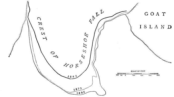
Fig. 106.—Map showing the recession of the Horseshoe Falls since 1842, as by survey mentioned in the text (Pohlman). (by courtesy of the American Institute of Mining Engineers.)
It will be perceived that the recession in the centre of the Horseshoe is very much more rapid than that nearer the margin; yet this rate at the centre is more nearly the standard of calculation than is that near the margin, for the gorge constantly tends to enlarge itself below the falls, and so gradually to bring itself into line with the full-formed channel. Taking all things into account, Mr. Woodward and the other members of the Geological Survey thought it not improbable that the average rate of actual recession in the Horseshoe Fall was as great as five feet per annum; and that, if we can rely upon the uniformity of the conditions in the past, seven thousand years is as long a period as can be assigned to its commencement.
The only condition in the problem about which there can be much chance of question relates to the constancy of the volume of water flowing in the Niagara channel. Mr. Gilbert had suggested that, as a consequence of the subsidence connected with the closing portions of the Glacial period, the water of the Great Lakes may have been largely diverted from its present outlet in Niagara River and turned northeastward, through Georgian Bay, French River, and Lake Nipissing, into a tributary of the Ottawa River, and so carried into the St. Lawrence below Lake Ontario. Of this theory there is also much direct evidence. A well-defined shore line of rounded pebbles extends, at an elevation of about fifty feet, across the col from Lake Nipissing to the head-waters of the Mattawa, a tributary of the Ottawa; while at the junction with the Ottawa there is an enormous delta terrace of boulders, forming a bar across the main stream just such as would result from Mr. Gilbert’s supposed outlet. But this outlet was doubtless limited to a comparatively few centuries, and Dr. Robert Bell thinks the evidence still inconclusive.[EB]
A second noteworthy glacial chronometer is found in the gorge of the Mississippi River, extending from the Falls of St. Anthony, at Minneapolis, to its junction with the preglacial trough of the old Mississippi, at Fort Snelling, a distance likewise of about seven miles.
Above Fort Snelling the preglacial gorge is occupied by the Minnesota River, and, as we have before stated, extends to the very sources of this river, and is continuous with the southern portion of the valley of the trough of the Red River of the North. Before the Glacial period the drainage of the present basin of the upper Mississippi joined this main preglacial valley, not at Fort Snelling, but some little distance above, as shown upon our map.[EC] This part of the preglacial gorge became partially filled up with glacial deposits, but it can be still traced by the lakelets occupying portions of the old depression, and by the records of wells which have been sunk along the line. When the ice-front had receded beyond the site of Minneapolis, the only line of drainage left open for the water was along the course of the present gorge from Minneapolis to Fort Snelling.
Here, as at Niagara, the problem is comparatively simple. The upper strata of rock consist of hard limestone, which is underlaid by a soft sandstone, which, like the underlying shale at Niagara, is eroded faster than the upper strata, and so a perpendicular fall is maintained. The strata are so uniform in texture and thickness that, with the present amount of water in the river, the rate of recession of the falls must have been, from the beginning, very constant. If, therefore, the rate can be determined, the problem can be solved with a good degree of confidence.
Fortunately, the first discoverer of the cataract—the Catholic missionary Hennepin—was an accurate observer, and was given to recording his observations for the instruction of the outside world and of future generations. From his description, printed in Amsterdam in 1704, Professor N. H. Winchell is able to determine the precise locality of the cataract when discovered in 1680.
Again, in 1766 the Catholic missionary Carver visited the falls, and not only wrote a description, but made a sketch (found in an account of his travels, published in London in 1788) which confirms the inferences drawn from Hennepin’s narrative. The actual period of recession, however (which Professor Winchell duly takes into account), extends only to the year 1856, at which time such artificial changes were introduced as to modify the rate of recession and disturb further calculations. But between 1680 and 1766 the falls had evidently receded about 412 feet. Between 1766 and 1856 the recession had been 600 feet. The average rate is estimated by Professor Winchell to be about five feet per year, and the total length of time required for the formation of the gorge above Fort Snelling is a little less than eight thousand years, or about the same as that calculated by Messrs. Woodward and Gilbert for the Niagara gorge.
To these calculations of Professor Winchell it does not seem possible to urge any valid objection. It does not seem credible that the amount of water in the Mississippi should ever have been less than now, while during the continuance of the ice in the upper portion of the Mississippi basin the flow of water was certainly far greater than now.
If any one is inclined to challenge Professor Winchell’s interpretation of the facts, even a hasty visit to the locality will suffice to produce conviction. The comparative youth of the gorge from Fort Snelling up to Minneapolis is evident: 1. From its relative narrowness, when compared with the main valley below. This is represented by the shading upon the map. The gorge from Fort Snelling up is not old enough to have permitted much enlargement by the gradual undermining of the superficial strata on either side, which slowly but constantly goes on. 2. From the abruptness with which it merges into the preglacial valley of the Minnesota-Mississippi. The opening at Fort Snelling is not Y-shaped, as in gorges where there has been indefinite time for the operation of erosive agencies. 3. Furthermore, the precipices lining the post-glacial gorge above Fort Snelling are far more abrupt than those in the preglacial valley below, and they give far less evidence of weathering. 4. Still, again, the tributary streams, like the Minnehaha River, which empty into the Mississippi between Fort Snelling and Minneapolis, flow upon the surface, and have eroded gorges of very limited extent; whereas, below Fort Snelling, the small streams have usually either found underground access to the river or occupy gorges of indefinite extent.
The above estimates, setting such narrow limits to post-glacial time in America, will seem surprising only to those who have not carefully considered the glacial phenomena of various kinds to be observed all over the glaciated area. As already said, the glaciated portion of North America is a region of waterfalls, caused by the filling up of old channels with glacial débris, and the consequent diversion of the water-courses. By this means the streams in countless places have been forced to fall over precipices, and to begin anew their work of erosion. Waterfalls abound in the glaciated region because post-glacial time is so short. Give these streams time enough, and they will wear their way back to their sources, as the preglacial streams had done over the same area, and as similar streams have done outside the glaciated region. Upon close observation, it will be found that the waterfalls in America are nearly all post-glacial, and that their work of erosion has been confined to a very limited time. A fair example is to be seen at Elyria, Ohio, in the falls of Black River, one of the small streams which empty into Lake Erie from the south. Its post-glacial gorge, worn in sandstone which overlies soft shale, is only about two thousand feet in length, and it has as yet made no approach toward a V-shaped outlet.
The same impression of recent age is made by examining the outlets of almost any of the lakes which dot the glaciated area. The very reason of the continued existence of these lakes is that they have not had time enough to lower their outlets sufficiently to drain the water off, as has been done in all the unglaciated region. In many cases it is easy to see that the time during which this process of lowering the outlets has been going on cannot have been many thousand years.
The same impression is made upon studying the evidences of post-glacial valley erosion. Ordinary streams constantly enlarge their troughs by impinging against the banks now upon one side and now upon the other, and transporting the material towards the sea. It is estimated by Wallace that nine-tenths of the sedimentary material borne along by rivers is gathered from the immediate vicinity of its current, and goes to enlarge the trough of the stream. Upon measuring the cubical contents of many eroded troughs of streams in the glaciated region, and applying the tables giving the average amount of annual transportation of sediment by streams, we arrive at nearly the same results as by the study of the recession of post-glacial waterfalls.
Professor L. E. Hicks, of Granville, Ohio, has published the results of careful calculations made by him, concerning the valley of Raccoon Creek in Licking County, Ohio.[ED] These show that fifteen thousand years would be more than abundant time for the erosion of the immediate valley adjoining that small stream. I have made and published similar calculations concerning Plum Creek, at Oberlin, in Lorain County, Ohio.[EE] Like Raccoon Creek, this has its entire bed in glacial deposits, and has had nothing else to do since its birth but to enlarge its borders. The drainage basin of the creek covers an area of about twenty-five square miles. Its main trough averages about twenty feet in depth by five hundred in width, along a distance of about ten miles. From the rate at which the stream is transporting sediment, it is incredible that it could have been at work at this process more than ten thousand years without producing greater results.
Calculations based upon the amount of sediment deposited since the retreat of the ice-sheet point to a like moderate conclusion. When one looks upon the turbid water of a raging stream in time of flood, and considers that all the sediment borne along will soon settle down upon the bottom of the lake into which the stream empties, he can but feel surprised that the “wash” of the hills has not already filled up the depression of the lake. It certainly would have done so had the present condition of things existed for an indefinite period of time.
Naturally, while prosecuting the survey of the superficial geology of Minnesota, Mr. Upham was greatly impressed by the continued existence of the innumerable lakelets that give such a charm to the scenery of that State. Every day’s investigations added to the evidence that the lapse of time since the Ice age must have been comparatively brief, since, otherwise, the rains and streams would have filled these basins with sediment, and cut outlets low enough to drain them dry, for in many instances he could see such changes slowly going forward.[EF]

Fig. 107.—Section of kettle-hole near Pomp’s Pond, Andover, Massachusetts (see text). (For general view of the situation, see Fig. 30, p. 78.)
Some years ago I myself made a careful estimate of the amount of deposition and vegetable accumulation which had taken place in a kettle-hole near Pomp’s Pond, in Andover, Mass. The diameter of the depression at the rim was 276 feet. The inclination of the sides was such that the extreme depression of the apex of the inverted cone could not have been more than seventy feet; yet the accumulation of peat and sediment only amounted to a depth of seventeen feet. The total amount of material which had accumulated would be represented by a cone ninety-six feet in diameter at the base and seventeen feet at the apex, which would equal only a deposit of about five feet over the present surface of the bottom. It is easy to see that ten thousand years is a liberal allowance of time for the accumulation of five feet of sediment in the bottom of an enclosure like a kettle-hole, for upon examination it is clear that whatever insoluble material gets into a kettle-hole must remain there, since there is no possible way by which it can get out. Now five feet is sixty inches, and if this amount has been six thousand years in accumulating, that would represent a rate of an inch in one hundred years, while, if it has been twelve thousand years in accumulation, the rate will be only one two-hundredth of an inch per year, a film so small as to be almost inappreciable. If we may judge from appearance, the result would not be much different in the case of the tens of thousands of kettle-holes and lakelets which dot the surface of the glaciated region.
In the year 1869 Dr. E. Andrews, of Chicago, made an important series of calculations concerning the rate at which the waters of Lake Michigan are eating into the shores and washing the sediment into deeper water or towards the southern end of the lake. With reference to the erosion of the shores, it appears from the work of the United States Coast Survey that a shoulder, covered with sixty feet of water, representing the depth at which wave-action is efficient in erosion, extends outward from the west shore a distance of about three miles, where the sounding line reveals the shore of the deeper original lake as it appeared upon the first withdrawal of the ice.
From a variety of observations the average rate at which the erosion of the bluffs is proceeding is found to be such that the post-glacial time cannot be more than ten thousand years, and probably not more than seven thousand.
An independent mode of calculating this period is afforded by the accumulations of sand at the south end of the lake, to which it is constantly drifting by the currents of water propelled against the shores by the wind; for the body of water in the lake is moving southward along the shores towards the closed end in that direction, there being a returning current along the middle of the lake. All the railroads approaching Chicago from the east pass through these sand deposits, and few of the observant travellers passing over the routes can have failed to notice the dunes into which the sand has been drifted by the wind. Now, all the material of these dunes and sand-beaches has been washed out of the bluffs to the northward by the process already mentioned, and has been slowly transferred by wave-action to its present position. It is estimated that south of Chicago and Grand Haven, this wave-transported sand amounts to 3,407,451,000 cubic yards. This occupies a belt curving around the south end about ten miles wide and one hundred miles long.
The rate at which the sand is moving southward along the shore is found by observing the amount annually arrested by the piers at Chicago, Grand Haven, and Michigan City. This equals 129,000 cubic yards for a year, which can scarcely be more than one quarter or one fifth of the total amount in motion. At this rate, the sand accumulations at the southern end of the lake would have been produced in a little less than seven thousand years.
“If,” says Dr. Andrews, “we estimate the total annual sand-drift at only twice the amount actually stopped by the very imperfect piers built—which, in the opinion of the engineers, is setting it far too low—and compare it with the capacity of the clay-basin of Lake Michigan, we shall find that, had this process continued one hundred thousand years the whole south end of Lake Michigan, up to the line connecting Chicago and Michigan City, would have been full and converted into dry land twenty-five thousand years ago, and the coast-line would now be found many miles north of Chicago.”[EG]
It is proper to add a word in answer co an objection which may arise in the reader’s mind, for it will doubtless occur to some to ask why this sand which is washed out by the waves from the bluffs is not carried inward towards the deeper portion of the trough of the lake, thus producing a waste which would partly counteract the forces of accumulation at the south end. The answer is found in the fact that the south end of Lake Michigan is closed, and that the currents set in motion by the wind are such that there is no off-shore motion sufficient to move sand, and, as a matter of fact, dredgings show that the sand is limited to the vicinity of the shore.
By comparing the eroded cliffs upon Michigan and the other Great Lakes with what occurs in similar situations about the glacial Lake Agassiz, we obtain an interesting means of estimating the comparative length of time occupied by the ice-front in receding from the Canadian border to Hudson Bay.
As we have seen, Lake Agassiz occupied a position quite similar in most respects to Lake Michigan. Its longest diameter was north and south, and the same forces which have eroded the cliffs of Lake Michigan and piled up sand-dunes at its southern end would have produced similar effects upon the shores of Lake Agassiz, had its continuance been anywhere near as long as that of the present Lake Michigan has been. But, according to Mr. Upham, who has most carefully surveyed the whole region, there are nowhere on the shores of the old Lake Agassiz any evidence of eroded cliffs at all to be compared with those found upon the present Great Lakes, while there is almost an entire lack of sand deposits about the south end such as characterise the shore of Lake Michigan. “The great tracts of dunes about the south end of Lake Michigan belong,” as Upham well observes, “wholly to beach accumulations, being sand derived from erosion of the western and eastern shores of the lake.... But none of the beaches of our glacial lakes are large enough to make dunes like those on Lake Michigan, though the size and depth of Lake Agassiz, its great extent from north to south, and the character of its shores, seem equally favorable for their accumulation. It is thus again indicated that the time occupied by the recession of the ice-sheet was comparatively brief.”[EH]
From Mr. Upham’s conclusions it would seem that if ten thousand years be allowed for the post-glacial existence of Lake Michigan, one tenth of that period would be more than sufficient to account for the cliffs, deltas, beaches, and other analogous phenomena about Lake Agassiz. In other words, the duration of Lake Agassiz could not have been more than a thousand years, which gives us a measure of the rate at which the recession of the ice-front went on after it had withdrawn to the international boundary. The distance from there to the mouth of Nelson River is about 600 miles. The recession of the ice-front over that area proceeded, therefore, at the average rate of about half a mile per year.
There are many evidences that the main period of glaciation west of the Rocky Mountains was considerably later than that in the eastern part of the continent. A portion of the facts pointing to this conclusion have been well stated by Mr. George F. Becker, of the United States Geological Survey.
“No one,” he says, “who has examined the glaciated regions of the Sierra can doubt that the great mass of the ice disappeared at a very recent period. The immense areas of polished surfaces fully exposed to the severe climate of say from 7,000 to 12,000 feet altitude, the insensible erosion of streams running over glaciated rocks, and the freshness of erratic boulders are sufficient evidence of this. There is also evidence that the glaciation began at no very distant geologic date. As Professor Whitney pointed out, glaciation is the last important geological phenomenon and succeeded the great lava flows. There is also much evidence that erosion has been trifling since the commencement of glaciation, excepting under peculiar circumstances. East of the range, for example, at Virginia City, andesites which there is every reason to suppose preglacial have scarcely suffered at all from erosion, so that depressions down which water runs at every shower are not yet marked with water-courses, while older rocks, even of Tertiary age and close by, are deeply carved. The rainfall at Virginia City is, to be sure, only about ten inches, so that rock would erode only say one third as fast as on the California coast; but even when full allowance is made for this difference, it is clear that these andesites must be much younger than the commencement of glaciation in the northeastern portion of the continent as usually estimated. So, too, the andesites near Clear Lake, in California, though beyond a doubt preglacial, have suffered little erosion, and one of the masses, Mount Konocti (or Uncle Sam), has nearly as characteristic a volcanic form as Mount Vesuvius.”[EI]
This view of Mr. Becker is amply sustained by many other obvious facts, some of which may be easily observed by tourists who visit the Yosemite Park. The freedom of the abutting walls of this cañon from talus, as well as the freshness of the glacial scratches upon both the walls and the floor of the tributary cañons, all indicate a lapse of centuries only, rather than of thousands of years, since their occupation by glacial ice.
The freshness of the high-level terraces surrounding the valleys of Great Salt Lake, in Utah, and of Pyramid and North Carson Lakes, in Nevada, and the small amount of erosion which has taken place since the formation of these terraces, point in the same direction—namely, to a very recent date for the glaciation of the Pacific coast.
We have already detailed the facts concerning the formation of these terraces and the evidence of their probable connection with the Glacial period. It is sufficient, therefore, here to add that, according to Mr. Russell and Mr. Gilbert (two of the most eminent members of the United States Geological Survey, who have each published monographs minutely embodying the results of their extensive observations in this region), the erosion of present streams in the beds which were deposited during the enlargement of the lakes is very slight, and the modification of the shores since the formation of the high terraces has been insignificant.
According to Mr. Gilbert: "The Bonneville shores are almost unmodified. Intersecting streams, it is true, have scored them and interrupted their continuity for brief spaces; but the beating of the rain has hardly left a trace. The sea-cliffs still stand as they first stood, except that frost has wrought upon their faces so as to crumble away a portion and make a low talus at the base. The embankments and beaches and bars are almost as perfect as though the lake had left them yesterday, and many of them rival in the symmetry and perfection of their contours the most elaborate work of the engineer. There are places where boulders of quartzite or other enduring rock still retain the smooth, glistening surfaces which the waves scoured upon them by clashing against them the sands of the beach.
“When this preservation is compared with that of the lowest Tertiary rocks of the region—the Pliocene beds to which King has given the name Humboldt—the difference is most impressive. The Pliocene shore-lines have disappeared.
“The deposits are so indurated as to serve for building-stone. They have been upturned in many places by the uplifting of mountains. Elsewhere they have been divided by faults, and the fragments, dissevered from their continuation in the valley, have been carried high up on the mountain-flanks, where erosion has carved them in typical mountain forms.... The date of the Bonneville flood is the geologic yesterday, and, calling it yesterday, we may without exaggeration refer the Pliocene of Utah to the last decade; the Eocene of the Colorado basin to the last century, and relegate the laying of the Potsdam sandstone to prehistoric times.”[EJ]
Mr. Russell adds to this class of evidence that of the small extent to which the glacial striæ have been effaced since the withdrawal of the ice from the borders of these old lakes: “The smooth surfaces are still scored with fine, hair-like lines, and the eye fails to detect more than a trace of disintegration that has taken place since the surfaces received their polish and striation.... It seems reasonable to conclude that in a severe climate like that of the high Sierra it” (the polish) “could not remain unimpaired for more than a few centuries at the most.”[EK]
Europe does not seem to furnish so favourable opportunities as America for estimating the date of the Glacial period; still it is not altogether wanting in data bearing upon the subject.
Some of the caves in which palæolithic implements were found associated with the bones of extinct animals in southern England contain floors of stalagmite which have been thought by some to furnish a measure of the time separating the deposits underneath from those above. This is specially true in the case of Kent’s Cavern, near Torquay, which contains two floors of stalagmite, the upper one almost continuous and varying in thickness from sixteen inches to five feet, the lower one being in places twelve feet thick, underneath which human implements were found.
But it is difficult to determine the rate at which stalagmite accumulates. As is well known, this deposit is a form of carbonate of lime, and accumulates when water holding the substance in solution drops down upon the surface, where it is partially evaporated. It then leaves a thin film of the substance upon the floor. The rate of the accumulation will depend upon both the degree to which the water is saturated with the carbonate and upon the quantity of the water which percolates through the roof of the cavern. These factors are so variable, and so dependent upon unknown conditions in the past, that it is very difficult to estimate the result for any long period of time. Occasionally a quarter of an inch of stalagmite accretion has been known to take place in a cavern in a single year, while in Kent’s Cavern, over a visitor’s name inscribed in the year 1688, a film of stalagmite only a twentieth of an inch in thickness has accumulated. If, therefore, we could reckon upon a uniformity of conditions stretching indefinitely back into the past, we could determine the age of these oldest remains of man in Kent’s Hole by a simple sum in arithmetic, and should infer that the upper layer of stalagmite required 240,000 years, and the lower 576,000 years, for their growth, which would carry us back more than 700,000 years, and some have not hesitated to affix as early a date as this to these lowest implement-bearing gravels.
But other portions of the cave show an actual rate of accretion very much larger. Six inches of stalagmite is there found overlying some remains of Romano-Saxon times which cannot be more than 2,000 years old. Assuming this as the uniform rate, the total time required for the deposit of the stalagmitic floors would still be about 70,000 years. But, as we have seen, the present rates of deposition are probably considerably less than those which took place during the moister climate of the Glacial epoch. Still, even by supposing the rate to be increased fourfold, the age of this lower stratum would be reduced to only 12,000 years. So that, as Mr. James Geikie well maintains, “Even on the most extravagant assumption as to the former rate of stalagmitic accretion, we shall yet be compelled to admit a period of many thousands of years for the formation of the stalagmitic pavements in Kent’s Cavern.”[EL] We should add, however, that there is much well-founded doubt whether the implements found in the lowest stratum were really in place, since, according to Dr. Evans, “Owing to previous excavations and to the presence of burrowing animals, the remains from above and below the stalagmite have become intermingled.”[EM]
An attempt was made by M. Morlot in Switzerland to obtain the chronology of the Glacial period by studying the deltas of the streams descending the glaciated valleys. He paid special attention to that of the Tinière, a stream which flows into Lake Geneva near Villeneuve. The modern delta of this stream consists of gravel and sand deposited in the shape of a flattened cone, and investigations upon it were facilitated by a long railroad cutting through it. “Three layers of vegetable soil, each of which must at one time have formed the surface of the cone, have been cut through at different depths.”[EN] In the upper stratum Roman tiles and a coin were found; in the second stratum, unvarnished pottery and implements of bronze; while in the lower stratum, at a depth of nineteen feet from the surface, a human skull was found, to which Morlot assigned an age of from 5,000 to 7,000 years.
But Dr. Andrews, after carefully revising the data, felt confident that the time required for the whole deposit of this lower delta was not more than 5,000 years, and that the oldest human remains in it, which were about half way from between the base and the surface of the cone, were probably not more than 3,000 years old.
Still, the significance of this estimate principally arises from the relation of the modern delta to older deltas connected with the Glacial period. Above this modern delta, formed by the river in its present proportions, there is another, more ancient, about ten times as large, whose accumulation doubtless took place upon the final retreat of the ice from Lake Geneva. No remains of man have been found in this, but it doubtless corresponds in age with the high-level gravels in the valley of the Somme, in which the remains of man and the mammoth, together with other extinct animals, have been found.
We do not see, however, that any very definite calculation can be made concerning the time required for its deposition. Lyell was inclined to consider it ten times as old as the modern delta, simply upon the ground of its being ten times as large. On Morlot’s estimate of the age of the modern delta, therefore, the retreat of the ice whose melting torrents deposited the upper delta would be fixed at 100,000 years ago, and upon Dr. Andrews’s calculation, at about 20,000.
But it is evident that the problem is not one of simple multiplication. The floods of water which accompanied the melting back of the ice from the upper portions of this valley must have been immensely larger than those of the present streams, and their transporting power immensely greater still. Hence we do not see that any conclusions can be drawn from the deltas of the Tinière to give countenance to extreme views concerning the date of the close of the Glacial period.[EO]
In the valley of the Somme the chronological data relating to the Glacial period, and indicating a great antiquity for man, have been thought to be more distinct than anywhere else in Europe. As already stated, it is the prevalent opinion that since man first entered the valley, in connection with the mammoth and the other extinct animals characteristic of the Glacial period, the trough of the Somme, about a mile in width and a hundred feet in depth, has been eroded by the drainage of its present valley. An extensive accumulation of peat also has taken place along the bottom of the trough of the river since it was originally eroded to its present level. This substance occurs all along the bottom of the valley from far above Amiens to the sea, and is in some places more than thirty feet in depth. The animal and vegetable remains in it all belong to species now inhabiting Europe.
The depth of the peat indicates that when it was formed the land stood at a slightly higher elevation than now, for the base of the stratum is now below the sea-level, while the peat is of fresh-water origin, and, according to Dr. Andrews,[EP] is formed from the vegetable accumulations connected with forest growths. When, therefore, the country was covered with forests, as it was in prehistoric times, the accumulation must have proceeded with considerable rapidity. This inference is confirmed by the occurrence in the peat of prostrate trunks of oak, four feet in diameter, so sound that they were manufactured into furniture. The stumps of trees, especially of the birch and alder, were also found in considerable number, standing erect where they grew, sometimes to a height of three feet. Now, as Dr. Andrews well remarks, it is evident that, in order to prevent these stumps and prostrate trunks from complete decay, the accumulation of peat must have been rapid. From certain Roman remains found six feet and more beneath the surface, he estimates that the accumulation since the Roman occupation has been as much as six inches a century, at which rate the whole would take place in somewhat over 5,000 years.
Still, if we accept this estimate, we have obtained but a starting-point from which to estimate the age of the high-level gravels in which palæolithic implements were found; for, if we accept the ordinary theory, we must add to this the time required for the river to lower its bed from eighty to a hundred feet, and to carry out to the sea the contents of its wide trough. But, as already shown, the Glacial period was, even in the north of France, a time of great precipitation and of a considerable degree of cold, when ice formed to a much greater extent than now upon the surface of the Somme. The direct evidence of this consists in the boulders mingled with the high-level gravel which are of such size as to require floating ice for their transportation.
In addition to the natural increase in the eroding power of the Somme brought about by the increase in its volume, on account of the greater precipitation in the Glacial age, there would also be, as Prestwich has well shown, a great increase in rate through the action of ground-ice, which plays a very important part in the river erosion of arctic countries, and in all probability did so during the Glacial period in the valley of the Somme.
“When the water is reduced to and below 32° Fahr., although the rapid motion may prevent freezing on the surface for a time, any pointed surfaces at the bottom of the river, such as stones and boulders, will determine (as is the case with a saturated saline solution) a sort of crystallisation, needles of ice being formed, which gradually extend from stone to stone and envelop the bodies with which they are in contact. By this means the whole surface of a gravelly river-bed may become coated with ice, which, on a change of temperature, or of atmospheric pressure, or on acquiring certain dimensions and buoyancy, rises to the surface, bringing with it the loose materials to which it adhered. Colonel Jackson remarks, in speaking of this bottom-ice, that ‘it frequently happens that these pieces, in rising from the bottom, bring up with them sand and stones, which are thus transported by the current.... When the thaw sets in the ice, becoming rotten, lets fall the gravel and stones in places far distant from those whence they came.’
“Again, Baron Wrangell remarks that, ‘in all the more rapid and rocky streams of this district [northern Siberia] the formation of ice takes place in two different manners; a thin crust spreads itself along the banks and over the smaller bays where the current is least rapid; but the greater part is formed in the bed of the river, in the hollows among the stones, where the weeds give it the appearance of a greenish mud. As soon as a piece of ice of this kind attains a certain size, it is detached from the ground and raised to the surface by the greater specific gravity of the water; these masses, containing a quantity of gravel and weeds, unite and consolidate, and in a few hours the river becomes passable in sledges instead of in boats.’ Similar observations have been made in America; but instances need not be multiplied, as it is a common phenomenon in all arctic countries, and is not uncommon on a small scale even in our latitudes.
“The two causes combined—torrential river-floods and rafts of ground-ice, together with the rapid wear of the river cliffs by frost—constituted elements of destruction and erosion of which our present rivers can give a very inadequate conception; and the excavations of the valleys must have proceeded with a rapidity with which the present rate of erosion cannot be compared; and estimates of time founded on this, like those before mentioned on surface denudation, are therefore not to be relied upon.”[EQ]
Speaking a little later of taking the present rates of river erosion as a standard to estimate the chronology of the Glacial period, the same high authority remarks: "It no more affords a true and sufficient guide than it would be to take the tottering paces and weakened force of an old man as the measure of what that individual was, and what he could do, in his robust and active youth. It may be right to take the effects at present produced by a given power as the known quantity, a, but it is equally indispensable, in all calculations relative to the degree of those forces in past times, to take notice of the unknown quantity, x, although this, in the absence of actual experience, which cannot be had, can only be estimated by the results and by a knowledge of the contemporaneous physical conditions. It may be a complicated equation, but it is not to be avoided.[ER]
“In this country and in the north of France broad valleys have been excavated to the depth of from about eighty to a hundred and fifty feet in glacial and post-glacial times. Difficult as it is by our present experience to conceive this to have been effected in a comparatively short geological term, it is equally, and to my mind more, difficult to suppose that man could have existed eighty thousand years or more, and that existing forms of our fauna and flora should have survived during two hundred and forty thousand years without modification or change.”[ES]
The discussion of the age of the high-level river gravels of the Somme and other streams in northwestern Europe is not complete, however, without considering another possibility as to the mode of their deposition. The conclusion to which Mr. Alfred Tylor arrived, after a prolonged and careful study of the subject, was that the main valleys of the Somme and other streams in northern France and southern England were preglacial in their origin, and that the accumulations of gravel at high levels along their margin were due to enormous floods which characterised the closing portion of the great ice age, which he denominated the pluvial period.[ET] The credibility of floods large enough to accomplish the results manifest in the valley of the Somme is supported by reference to a flood which occurred on the Mulleer River, in India, in 1856, when a stream, which is usually insignificant, was so swollen by a rainfall of a single day that it rose high enough to sweep away an iron bridge the bottoms of whose girders were sixty-five feet above high-water mark. One iron girder weighing eighty tons was carried two miles down the river, and nearly buried in sand. The significance of these facts is enhanced by observing also that for fifteen miles above the bridge the fall of the river only averaged ten feet per mile. Floods to this extent are not uncommon in India. During the Glacial period spring freshets, must have been greatly increased by the melting of a large amount of snow and ice which had accumulated during the winter, and also by the formation of ice-gorges near the mouths of many of the streams. It is probable, also, that the accumulation of ice across the northern part of the German Ocean may have permanently flooded the streams entering that body of water; for it is by no means improbable that there was a land connection between England and France across the Straits of Dover until after the climax of the Glacial period. In support of his theory, Mr. Tylor points to the fact “that the gravel in the valley of the Somme at Amiens is partly derived from débris brought down by the river Somme and by the two rivers the Celle and the Arve, and partly consists of material from the adjoining higher grounds washed in by land floods,” and that the “Quaternary gravels of the Somme are not separated into two divisions by an escarpment of chalk parallel to the river,” but “thin out gradually as they slope from the high land down to the Somme.”
Mr. Tylor’s reasoning seems especially cogent to one who stands on the ground where he can observe the size of the valley and the diminutive proportions of the present stream. Even if we do not grant all that is claimed by Mr. Tylor, it is difficult to resist the main force of his argument, and to avoid the conclusion that the valley of the Somme is largely the work of preglacial erosion, and has been, at any rate, only in slight degree deepened and enlarged during post-Tertiary time.
Summary.
In briefly summarising our conclusions concerning the question of man’s antiquity as affected by his known relations to the Glacial period, it is important, first, to remark upon the changes of opinion which have taken place with respect to geological time within the past generation. Under the sway of Sir Charles Lyell’s uniformitarian ideas, geologists felt themselves at liberty to regard geological time as practically unlimited, and did not hesitate to refer the origin of life upon the globe back to a period of 500,000,000 years. In the first edition of his Origin of Species Charles Darwin estimated that the time required for the erosion of the Wealden deposits in England was 306,662,400 years, which he spoke of as “a mere trifle” of that at command for establishing his theory of the origin of species through natural selection. In his second edition, however, he confesses that his original statement concerning the length of geological time was rash; while in later editions he quietly omitted it.
Meanwhile astronomers and physicists have been gradually setting limits to geological time until they have now reached conclusions strikingly in contrast with those held by the mass of English geologists forty years ago. Mr. George H. Darwin, Professor of Mathematics at Cambridge University, has from a series of intricate calculations shown that between fifty and one hundred million years ago the earth was revolving from six to eight times faster than now, and that the moon then almost touched the earth, and revolved about it once every three or four hours. From this proximity of the moon to the earth, it would result that if the oceans had been then in existence the tides would have been two hundred times as great as now, creating a wave six hundred feet in height, which would sweep around the world every four hours. Such a condition of things would evidently be incompatible with geological life, and geology must limit itself to a period which is inside of 100,000,000 years. Sir William Thomson and Professor Tait, of Great Britain, and Professor Newcomb, of the United States Naval Observatory, approaching the question from another point of view, seem to demonstrate that the radiation of heat from the sun is diminishing at a rate such that ten or twelve million years ago it must have been so hot upon the earth’s surface as to vaporise all the water, and thus render impossible the beginning of geological life until later than that period. Indeed, they seem to prove by rigorous mathematical calculations that the total amount of heat originally possessed by the nebula out of which the sun has been condensed would only be sufficient to keep up the present amount of radiation for 18,000,000 years.
The late Dr. Croll, feeling the force of these astronomical conclusions, thought it possible to add sufficiently to the sun’s heat to extend its rule backwards approximately 100,000,000 years by the supposition of a collision with it of another moving body of near its own size. Professor Young and others have thought that possibly the heat of the sun might have been kept up by the aid of the impact of asteroids and meteorites for a period of 30,000,000 years. Mr. Wallace obtains similar figures by estimating the time required for the deposition of the stratified rocks open to examination upon the land surface of the globe. As a result of his estimates, it would appear that 28,000,000 years is all the time required for the formation of the geological strata. From all this it is evident that geologists are much more restricted in their speculations involving time than they thought themselves to be a half-century ago. Taking as our standard the medium results attained by Wallace, we shall find it profitable to see how this time can be portioned out to the geological periods, that we may ascertain how much approximately can be left for the Glacial epoch.
On all hands it is agreed that the geological periods decrease in length as they approach the present time. According to Dana’s estimates,[EU] the “ratio for the Palæozoic, Mesozoic, and Cenozoic periods would be 12:3:1”—that is, Cenozoic time is but one sixteenth of the whole. This embraces the whole of the Tertiary period, during which placental mammals have been in existence, together with the post-Tertiary or Glacial period, extending down to the present time; that is, the time since the beginning of the Tertiary period and the existence of the higher animals is considerably less than two million years, even upon Mr. Wallace’s basis of calculation. But if we should be compelled to accept the calculations of Sir William Thomson, Professor Tait, and Professor Newcomb, the Cenozoic period would be reduced to considerably less than one million years. It is difficult to tell how much of Cenozoic time is to be assigned to the Glacial period, since there is, in fact, no sharply drawn line between the two periods. The climax of the Glacial period represented a condition of things slowly attained by the changes of level which took place during the latter part of the Tertiary epoch.
In order to estimate the degree of credibility with which we may at the outset regard the theory of Mr. Prestwich and others, that all the phenomena of the Glacial period can be brought within the limits of thirty or forty thousand years, it is important to fix our minds upon the significance of the large numbers with which we are accustomed to multiply and divide geological quantities.[EV]
Few people realise either the rapidity with which geological changes are now proceeding or the small amount of change which might produce a Glacial period, and fewer still have an adequate conception of how long a period a million years is, and how much present geological agencies would accomplish in that time. At the present rate at which erosive agencies are now acting upon the Alps, their dimensions would be reduced one half in a million years. At the present rate of the recession of the Falls of St. Anthony, the whole gorge from St. Louis to Minneapolis would have been produced in a million years. A river lowering its bed a foot in a thousand years would produce a cañon a thousand feet deep in a million years.
If we suppose the Glacial period to have been brought about by an elevation of land in northern America and northern Europe, proceeding at the rate of three feet a century, which is that now taking place in some portions of Scandinavia, this would amount to three thousand feet in one hundred thousand years, and that is probably all, and even more than all, which is needed. One hundred thousand years, therefore, or even less, might easily include both the slow coming on of the Glacial period and its rapid close. Prestwich estimates that the ice now floating away from Greenland as icebergs is sufficient if accumulating on a land-surface to extend the borders of a continental glacier about four hundred and fifty feet a year, or one mile in twelve years, one hundred miles in twelve hundred years, and seven hundred miles (about the limit of glacial transportation in America) in less than ten thousand years.
After making all reasonable allowances, therefore, Prestwich’s conclusion that twenty-five thousand years is ample time to allow to the reign of the ice of the Glacial period cannot be regarded as by any means incredible or, on a priori grounds, improbable.
APPENDIX.
THE TERTIARY MAN.
By Professor Henry W. Haynes.
“It must not be imagined that it is in any way proved that the Palæolithic man was the first human being that existed. We must be prepared to wait, however, for further and better authenticated discoveries before carrying his existence back in time further than the Pleistocene or post-Tertiary period.”[EW] This was the position assumed more than twelve years ago by the eminent English geologist and archæologist, Dr. John Evans, and it was still maintained in his address before the Anthropological Section of the British Association on September 18, 1890. I believe that the study of all the evidence in favor of the existence of the Tertiary man that has been brought forward down to the present time will leave the question in precisely the same state of uncertainty.
“In order to establish the existence of man at such a remote period the proofs must be convincing. It must be shown, first, that the objects found are of human workmanship; secondly, that they are really found as stated; and, thirdly, the age of the beds in which they are found must be clearly ascertained and determined.”[EX] These tests I propose to apply to the evidence for the Tertiary man recently brought forward in Europe, and then to consider the significance of certain discoveries on the Pacific coast of our own continent.
Tertiary deposits in Europe are alleged to have supplied three sorts of evidence of this fact: First, the bones of man himself; second, bones of animals showing incisions or fractures supposed to have been produced by human agency; third, chipped flints believed to exhibit marks of design in their production.
A very complete survey of the question of the antiquity of man was published in 1883 by M. Gabriel de Mortillet, one of its most eminent investigators, under the title of Le Préhistorique. In that work he subjected to a most rigid examination all the evidence for Tertiary man, coming under either of these three heads, that had been brought forward up to that date.
The instances of the discovery of human bones in Europe were two—at Colle del Vento, in Savona, and Castenedolo, near Brescia, both in Italy. At the former site, in a Pliocene marine deposit abounding in fossil oysters and containing some scattered bones of fossil mammals, a human skeleton was found with the bones lying in their natural connection. Mortillet, however, and many others regard this as an instance of a subsequent interment rather than as proof that the man lived in Pliocene times.[EY] At Castenedolo, in a similar marine Pliocene formation, on three different occasions human skeletons have been discovered, but in different strata. One investigator has accounted for these as the result of a shipwreck in the Pliocene period. This bold hypothesis not only requires that man should have been sufficiently advanced at that very remote period to have navigated the sea, but it calls for two shipwrecks, at different times, at the same point. It has, however, since been abandoned by its author in favor of the presumption of subsequent interments, as in the previous instance.[EZ]
Animal bones showing cuts or breaks supposed to be the work of man have been found in seventeen different localities in Europe. They can all, however, be accounted for as the result of natural movements or pressure of the soil acting in connection with sharp substances, like fractured flints, or else as having been made by the teeth of sharks, whose fossil remains are found in great abundance in the same formation.
All the discoveries of flints supposed to show traces of intentional chipping are pronounced to be unsatisfactory, with the exception of those found in three localities—Thenay (near Tours) and Puy-Courny (near Aurillac), in France, and Otta, in the valley of the Tagus, in Portugal. As European archæologists at the present time are substantially in accord with Mortillet in restricting the discussion to these three places, I will follow their example. But although Mortillet believes that flints found at all these localities exhibit marks of intelligent action, he will not admit that they are the work of man. He attributes them to an intelligent ancestor of man, whom he calls by the name of anthropopithecus, or the precursor of man. Of this creature he distinguishes three different species, named respectively after the discoverers of the flints in the three localities just mentioned. The precursor, however, has found up to this time only a very limited acceptance among men of science, although a few believe in him on purely theoretical grounds. The discussion generally turns upon the question whether these flints were chipped intentionally or are the result of natural causes; and also upon the determination of the geological age of the formations in which they are found.
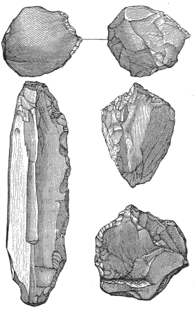
Fig. 108.—Flint flakes collected by Abbé Bourgeois from Miocene strata at Thenay (after Gaudry). Natural size.
I visited Thenay, the most celebrated of these three localities, in 1877, and had the advantage of studying the question there under the guidance of the late Abbé Bourgeois, the discoverer of the flints, and one of the most prominent advocates of the Tertiary man. This was the year before he died, and he showed me at the time his complete collection, and gave me several of the objects he had discovered. Geologists are agreed in assigning the deposits in which they occur to the lower Miocene or middle Tertiary period, which restricts the discussion to the character of the flints themselves. The accompanying woodcut[FA] gives some indication of their appearance, although it is misleading, because the long figure resembling a flint knife is intended to represent a solid nucleus. None of these objects, however, ought to be called “flints flakes,” as very few, if any, flakes showing the “bulb of percussion,” always seen upon them, have been discovered in the Tertiary deposits at Thenay,[FB] although I have found them there myself upon the surface. The three other figures would be classed by archæologists as “piercers,” as Bourgeois has himself designated them, and are also solid objects. Many of the Thenay flints exhibit a “crackled” appearance, due to the action of heat. On this account Mortillet maintains that they were splintered by fire, and not formed by percussion, the usual method by which flint implements were fabricated in the stone age. The Thenay objects are all of very small dimensions, and are so absolutely unlike the large, rudely-chipped axes of the Chellean type, found in so many different parts of the world, and generally accepted as the implement used by Palæolithic man, that the question naturally suggests itself, What could have been the purpose for which these little implements were employed? No better answer has been suggested than the ludicrous one that they were used by the hairy anthropopithecus to rid himself of the vermin with which he was infested.
But, leaving aside the question of their purpose, let us consider the evidence presented by the flints themselves. Do they exhibit the unmistakable traces of intentional chipping produced by a series of slight blows or thrusts, delivered in regular succession and in the same direction, with the result of forming a distinctly marked edge? And does the appearance of the action of fire upon their surface imply the intervention of intelligence? To both questions M. Adrien Arcelin, the well-known geologist of Mâcon, has given very sufficient replies in the negative. He has discovered numerous objects of precisely similar appearance in Eocene deposits in the neighborhood of Mâcon.[FC] But, instead of pushing man back on this account so much further into the past, he accounts for the marks of chipping to be seen on many of these objects as the result of the accidental shocks of one stone against another in the countless overturnings and movements to which the strata have been subjected during the long ages of geological time. He gives photographs of some of these objects, which are to me entirely convincing, and describes how he has surprised Nature in the very act of fabricating them in an abandoned quarry worked in an Eocene deposit. He thinks the “crackled” surfaces can be readily explained as the result of atmospheric action, or of hot springs charged with silex. Numerous examples of similar changes in the surface of flint, that have been noticed by himself and others in different localities, are instanced. Even if some have been caused by fire, this does not necessarily imply the intervention of man to have produced it. Similar discoveries have also been made by M. d’Ault de Mesnil, at Thenay, in Eocene deposits,[FD] and by M. Paul Cabanne, in the Gironde.[FE] My own opinion, based upon the experience of many years spent in the study of flints broken naturally as well as artificially, and upon a careful examination of Bourgeois’s collections, is that the so-called Thenay flints are the result of natural causes.
The second locality where flints alleged to display marks of human action have been found is the vicinity of Aurillac, in the Auvergne, especially on the flanks of a hill called Puy-Courny. They occur in a conglomerate of the upper Miocene period, and are consequently much later than the Thenay flints. In this conglomerate, in 1869, M. Tardy discovered a worked flint flake which has every appearance of being artificial.[FF] Mortillet, however, says that it was found in the upper surface of the deposit, where there may easily have been a mingling with the Quaternary formation; and it certainly resembles worked flakes, which are not uncommon in the Quaternary. The geological determination of the find may consequently be regarded as uncertain.
The flints discovered at Puy-Courny by M. Barnes are of small dimensions, and have all been produced by percussion. Many of them are said to bear some resemblance to pointed flakes of artificial origin, and one has been figured, probably selected for its excellence.[FG] It is by no means convincing to me, and I am not at all surprised that so many archæologists question the artificial character of these objects, which exhibit a great variety of forms. Upon this point Rames does not profess to be qualified to pronounce judgment, limiting himself solely to the geological questions. He argues, however, that the fact that all the objects supposed to be artificial are made of the best qualities of flint, of which implements are ordinarily made, although fragments of inferior quality are abundant in the same formation, implies the intervention of man’s judgment in making the selection. But M. Boule shows that this is merely the result of the erosion of an ancient river, which operated only upon the upper beds, in which alone the better qualities of flint are to be found; and Rames has accepted this explanation.[FH] The flints of Puy-Courny seem to fall within the same category as those of Thenay. They are the product of denudation, have travelled long distances, and have been subjected to the action of powerful agents. These causes are sufficient to account for the shocks of which they show the traces, and to explain the production of splinters arising therefrom.
The last locality in which flints claimed to have been manufactured by the Tertiary man are supposed to have been discovered is the so-called desert of Otta, in the valley of the Tagus, not far from Lisbon.
The formation there is a lacustrine deposit of great thickness, belonging to the upper Miocene, and abounding in flint. Here, during the course of twenty years, M. Ribeiro discovered, but mostly upon the surface, a large number of flakes of flint and quartzite. After much debate in regard to them, ninety-five of them were finally sent by him to Paris, in 1878, and placed in the archæological department of the great exposition. There they were to be submitted to the judgment of the assembled prehistoric archæologists of all nationalities, many of whom, including the writer, availed themselves of the opportunity of carefully studying them. The judgment of Mortillet is that twenty-two specimens exhibited unmistakable traces of intentional chipping, in which opinion I entirely concur. Only nine, however, were represented as coming from the Miocene, some of which showed on their surface an incrustation of grit, which was claimed as proof of their origin. But the opinion was freely expressed that, even if they really came from the Miocene deposits, they might have penetrated into them from the surface, through cracks, and thus have become so incrusted. It was accordingly resolved to hold the next international congress of prehistoric archæologists at Lisbon, in 1880, mainly for the purpose of settling this question, if possible, by an investigation conducted upon the spot. In the course of a visit made at that time to Otta, several artificial specimens were found on the surface by different searchers, but Professor Bellucci, of Perugia, was fortunate enough to discover a flint flake in situ, still so closely imbedded in the deposit that it required to be detached by a hammer. There is no question that this object was actually found in a Miocene deposit, but unfortunately it belongs to the doubtful category of external flakes, which, although they exhibit the “bulb of percussion,” have no other sure indication that they are the work of man.[FI] As such bulbs can be produced by natural causes, some stronger proof than this of the existence of Tertiary man is demanded.
These are all the localities in Europe claimed by Mortillet to have furnished such evidence, but he thinks a strong confirmation of it is afforded by certain discoveries made in the auriferous gravels of California. I will not occupy space here in repeating arguments I have brought forward elsewhere to show the utter insufficiency of this evidence to prove the existence of man on the Pacific coast of our continent during the Pliocene period,[FJ] They may all be summed up in the words of Le Conte: “The doubts in regard to this extreme antiquity of man are of three kinds, viz.: 1. Doubts as to the Pliocene age of the gravels—they may be early Quaternary. 2. Doubts as to the authenticity of the finds—no scientist having seen any of them in situ. 3. Doubts as to the undisturbed conditions of the gravels, for auriferous gravels are especially liable to disturbance. The character of the implements said to have been found gives peculiar emphasis to this last doubt, for they are not Paleolithic, but Neolithic.”[FK] The question has been raised whether this archæological objection is applicable to the stone mortars, numerous examples of which have been found in the gravels, some of them quite recently.[FL] If the evidence brought forward by Professor Whitney and others were limited to these mortars, it might very well be claimed that they are neither Palæolithic nor Neolithic; that the smoothness of their surface is owing to their having been hollowed out of pebbles that have been polished and worn by natural forces. But Professor Whitney has cited numberless instances of “spear-heads,” "arrow-heads," “discoidal stones,” "stone beads," and “a hatchet” that have been found under precisely similar conditions as the mortars. So Mr. Becker has recently produced an affidavit of a certain Mr. Neale that in a tunnel run into the gravel in 1877 “between two hundred and three hundred feet beyond the edge of the solid lava, he saw several spear-heads nearly one foot in length.”[FM] Now it cannot be questioned that such objects as these clearly belong to the Neolithic period, which does not imply that all the objects used at that time were polished, but that together with chipped implements “polished stone implements were also used.”[FN] No archæologist will believe that, while Palæolithic man has not yet been discovered in the Tertiary deposits of western Europe, the works of Neolithic man have been found in similar deposits in western America. Peculiar difficulties seem to surround the evidence brought forward in support of such an assumption. We are told by Professor Whitney that a stone mortar was “found standing upright, and the pestle was in it, in its proper place, just as it had been left by the owner.” He fails, however, to explain how this was brought about in a gravel deposit supposed to have been laid down by great floods of water. So, when Mr. Neale swears that he saw fifteen years ago in the same gravels spear-heads a great deal larger than those known to archæologists, may we not ask whether reliance can be placed on the memory of witnesses who testify to impossibilities to justify conclusions that rest upon such testimony? I think we shall have to wait for further and better evidence than this before we are called upon to admit that the existence of the Tertiary man upon our Pacific coast has been established.
INDEX.
Aar Glacier 11, 43, 132. Abbeville, France, 251, 263. Abbott, C. C, cited, 242, 245. Adams, Charles Francis, cited, 297. Adhémar, cited, 307, 310. Africa, ancient glaciers of, 191. Agassiz, Louis, cited, 9, 11, 43, 128, 241. Ailsa Crag, 167, 168. Akron. Ohio, 220, 221. Alaska, 1, 22, 23 et seq., 47, 212, 283; climate of, 291, 302. Aletsch Glacier, 9, 211, 241. Alleghany Valley, 206, 214; terraces in, 229. Alpine glaciers, existing, 9-11, 43 et seq.; size and number of, 9; depth of, 11; velocity of, 43 et seq.; ancient, 58-60, 131-136; advance and retreat of, 116. Alps, 1, 9-11, 43 et seq., 58 et seq., 91, 131 et seq., 211; age of, 328. Altaville, Cal, 296. Amazon Valley, temperature of, 316. Amherst, Ohio, glacial marks near, 52. Amiens, France, implements from, 252, 263 et seq.; terraces at, 360. Andes, 17, 330; age of, 328. Andover, Mass., 77 et seq., 345. Andrews, cited, 345, 347, 354, 356. Animals, extinct, associated with man in eastern America, 262; in France, 263; in England, 264 et seq.; in Wales, 272; in Belgium, 277 et seq.; summary concerning, 281-293. Animals, relics of, in loess, 188. Antarctic Continent, existing glaciers of, 1, 18 et seq. Arcy, Belgium, grotto at, 279. Arenig Mawr, Wales, 150, 151, 172. Argillite implement, face and side view of, 247, 259. Arnhem, Holland, moraine at, 181. Asia, existing glaciers in, 14 et seq.; ancient glaciers of, 190. Assiniboine River, 228. Astronomical theories of the Glacial period, 303 et seq. Atlantic Ocean, 314. Aurillac, supposed flint-chips near, 367, 370. Australia, ancient glaciers of, 126, 192. Austria, existing glaciers of, 9. Auvergne, 136. Babbitt, Miss F. E., cited, 253, 254, 255. Bakewell on age of Niagara gorge, 337. Baldwin, C. C, 251. Baldwin, P., 25. Ball, cited, 310, 317. Baltic Sea, 129. Barnsley, England, 155. Bates, cited, 204. Bear, 270, 287, 290. Bear, grizzly, 270, 288. Beaver, 289. Beaver Creek, Pa., 205, 230, 232. Becker, cited, 296, 300, 349. Bedford, England, 265. Beech Flats, Ohio, terrace at, 217. Belgium, human relics in glacial terraces in, 264; caverns of, 274. Bell, cited, 109, 117; on unity of the Glacial period, 110. Bellevue, Pa., glacial terrace on the Ohio at, 217. Bellucci, cited, 372. Ben Nevis, 240. Bernese Oberland, 9, 59, 131, 132. Big Stone Lake, 208, 226. Birmingham. England, 150. Bishop, cited, 306. Bison, 262, 270, 271, 278, 289. Black Forest, the, 136. Black River, Ohio, 343. Black Sea, 238. Blanc, Mont, 1, 9-11, 132, 211. Blandford, cited, 312. Boone County, Ky., glacial deposits in, 212. Boston, scratched stone from till of, 54; drumlins in the vicinity of, 75. Boston Society of Natural History, 296. Boulder-clay. (See Till.) Boulders, disintegrated, 57, 71. Boulders, distribution of, in New-England, 57, 60, 61, 69 et seq.; in Switzerland, 58 et seq., 133. Boulders, transportation of, in Pennsylvania, 57, 61, 85; in New Hampshire, 60, 71; in Kentucky, 63, 97; in Ohio, 64, 72; in Rhode Island, 67; in Massachusetts, 69 et seq.; in Connecticut, 71, 72; in New Jersey, 83; in Illinois, 97. Bourgeois, Abbé, cited, 367. Bridgenorth, England, 150. Bridlington, England, 156, 158. Bristol Channel, 138, 178. British Columbia, 1, 23, 121 et seq., 194, 198. British Isles, ancient glaciers of, 136-181; preglacial level of land in, 139-141; preglacial climate in 141, 142; great glacial centres— Wales, 143; Ireland, 143; Galloway, 144; Lake District, 144; Pennine Chain, 144; confluent glaciers— Irish Sea Glacier, 145-153; Solway Glacier, 153-158; East Anglian Glacier, 158; Isle of Man, 164-167; the so-called Great Submergence, 167-180; dispersion of erratics of Shap granite, 180, 181; drainage of, 238; caverns of, 267; climate of, 314. Brixham Cave, 267 et seq. Bromsgrove, England, 150. Brooklyn, N. Y., 66, 67. Brown, on glaciers of Greenland, 40, 41. Brown’s Valley, 226. Bruce, skull of, 276. Buried forests in America, 107 et seq. Buried outlets and channels, 199-210; of Lake Erie, 201, 333; of Lake Huron, 202; of Lake Ontario, 202; of Lake Superior, 203; of Lake Michigan, 203; in southwestern Ohio, 203; near Cincinnati, 203; near Louisville, Ky., 205; in the Tuscarawas Valley, 205; in the valley of the Beaver, 205; of oil Creek, 205; in the valley of the Alleghany, 206; of Chautauqua Lake, 207; near Minneapolis, 208. Burton, England, 164. Busk, cited, 267. Buttermere, England, 153, 168. Cache Valley, Utah, 233. Cae Gwyn Cave, 148, 271 et seq., 280. Caithness, Scotland, 180. Calaveras skull, 295, 300. California, 21, 124, 281, 287, 294, 358, 372. Cambridgeshire, England, 158. Canada, 94, 95. Canstadt, man of, 279. Canton, Ohio, 232. Cape St. Roque, 31 3. Caribbean Sea, 318. Caribou, 262. Carll, cited, 205, 207. Carpathian Mountains, 136, 328. Carpenter, F. R., cited, 321, 322. Cascade Range, 21. Caspian Sea, 238. Cattaraugus Creek, N. Y., 220. Caucasus Mountains, 15; age of, 328. Cave-bear, 269-271, 278, 280; hyena, 269, 270, 278; lion, 269-271, 278. Caverns, British, 267-274; on the Continent, 274-281. Cefn Cave, 148, 271. Cenis, Mont, 135. Centres of glacial dispersion, 304 et seq., 323 et seq., 328; in America, 113, 121; in Europe, 129 et seq.; in the British Isles, 142 et seq. Cevennes, 136. Chamberlin, T. C, terminal moraine of second Glacial epoch, 93, 98 et seq.; on driftless area, 102, 103; cited, 110, 218, 229, 307; on Cincinnati ice-dam, 218. Chamois, 289, 290. Chamouni, 132. Charpentier, 9, 59. Chasseron, 58, 132. Chautauqua Lake, buried outlet of, 207. Chenango River, 220. Cheshire, England, 149,153,178,180. Cheyenne River, 228. Chicago, Ill., 346. Chimpanzee, skull of, 276. Chur, 133. Cincinnati, buried channels near, 203 et seq.; glacial dam at, 212 et seq.; terraces at, 231. Clarksburg, W. Va., 216. Claymont, Del., 258 et seq.; view of implement found near, 259. Claypole, cited, 200, 219, 221. Climate of Glacial period, 291. Clwyd, vale of, 147 et seq.. 271 et seq. Clyde, the, 144. Collett, cited, 107. Colorado, 123, 124. Columbia deposit, 245, 254 et seq. Columbiana County, Ohio, 232. Comstock, cited, 307. Conewango Creek, 232; ancient depth of, 206. Connecticut, 71, 72, 74, 91. Conyers, cited, 265. Cook on subsidence in New Jersey, 196. Cope, cited, 288. Cordilleran Glacier, 121 et seq. Corswall, England, 312. Cows, 268. Cresson, cited, 251, 258 et seq. Crevasses. (See Fissures.) Croll, cited, 304, 307 et seq., 332, 362. Cro-Magnon, rock shelter of, 281. Cromer, England, 160. Crosby, on composition of till, 81 et seq. Cross Fell escarpment, 153, 180. Culoz, 132. Cumberland, England, 146, 153, 168, 173. Gumming, quoted, 166. Gushing, H., 26 Cuyahoga River, 220, 221; buried channel of, 200. Dana, Professor J. D., on depth of ice, 91; on driftless area, 102; cited, 320, 363. Danube, ancient glaciers of the, 129, 134, 188. Darent, valley of, 265. Darrtown, Ohio, 107. Darwin, Charles, cited, 17, 126, 170, 241, 361. Darwin, George G., cited, 361. Darwin, Mrs. M. J., mortar owned by, 297. Date of Glacial period, chapter on, 332-364. Davidson Glacier, 23. Davis on drumlins, 75. Dawkins, cited, 238, 267, 269, 291. Dawson, G. M., cited, 121; on ice-movements, 97; on oscillation of land-level, 125, 126. Dawson, Sir William, on the fiord of the Saguenay, 197; cited, 285. Dee, the river, 149. Deeley, quoted, 164. Delaware River, 232, 242 et seq., 254, 258; section across the, 245. Delta terrace at Trenton, N. J., 242 et seq.; at Beaver, Pa., 230. De Ranee, cited, 272. Derbyshire, England, 270. Desor on age of Niagara gorge, 337. Diore, glaciers of the, 135. Disintegration, amount of, near glacial margin, 117, 118. Diss, England, 266. Dnieper, the, 185, 188. Don, the, 185, 188. Dora Baltea, 134. Dover, N. H., section of kame near, 77. Dover, Straits of, 238. Drave, glaciers in the, 134. Drainage systems in the Glacial period, 335, 339, 340, 343, 344; chapter on, 193-241. Drayson, cited, 317. Driftless area in the Mississippi Valley, 101, 102. Drumlins, description of, 73 et seq.; view of, 73; occurrence of, in Massachusetts, 73; in New Hampshire, 74; in Connecticut, 74; in New York, 74, 94; in the British Isles, 74, 137, 167. Dunbar, Scotland, 312. Dupont, cited, 279. Du Quoin, Ill., 98, 119. D’Urville, 20. Düsseldorf, 275. Eagle, Wis., view of kettle-moraine near, 99. East Anglian Glacier, 158-164. Eccentricity of the earth’s orbit, 308. Eden Valley, 180. Eggischorn, 211, 241. Eguisheim, skull found at, 279. Elephant, 265, 280, 282, 283, 292. Elevation, preglacial, 112, 194, 198; the cause of the Glacial period, 113, 320-331; about the Great Lakes, 224; in the latitude of New York, 261. Elyria, Ohio, 342. Engis skull, view of, 274. England. (See British Isles.) Enville, England, 150. Erosion, preglacial, 193 et seq. Erosion in river valleys, 198, 329, 332. Erzgebirge, 136, 181. Europe, existing glaciers in, 9, et seq., 43 et seq.; ancient glaciers of, 129-190; former elevation of, 238; ice-dams in, 360. Evans, cited, 263, 267, 354, 365. Falconer, cited, 263. Falls of St Anthony, 200. Faudel, cited, 279. Fiesch, Switzerland, 131, 211. Filey Brigs;, Eng., 155. Finchley, Eng., 158, 159. Finger Lakes, 94. Finsteraarhorn, 9. Fiords, 194 et seq.; of Greenland, 212. Fissures in glacial ice, 3, 48, 49. Flamborough, 140, 156, 157, 176. Florida, 314. Flower, cited, 263. Forbes, 9, 38, 43, 44, 48. Forel, M., cited, 116. Fort Snelling, Mississippi gorge at, 208, 340 et seq. Fort Wayne, Incl., 220, 224. Foshay, cited, 119. Fox, 270, 289, 290. Fraipont, cited, 275 et seq. France, existing glaciers of, 19; ancient glaciers of, 136; glacial gravels of, 262 et seq. Frankley Hill, England, 150. Franklin, Pa., 230, 232. Franz-Josef Land, 14. Frederickshaab Glacier, 91, 212. Frere, cited, 266. Frickthal, 133. Frondeg, Wales, 149, 178. Gabb, cited, 318. Galloway, ancient glaciers of, 144, 145, 154, 157, 167, 168, 173. Garda, Lake, moraine in front of, 135. Garonne, the, 136, 188. Gaudry, cited, 263. Geikie, Archibald, cited, 272, 312. Geikie, James, on kames, 76; on loess, 187, 188; cited, 291 et seq., 307, 353. Genesee River, 220. Geological time, 361 et seq. Georgian Bay, 339. German Ocean, 129. Germantown, Ohio, 107, 108. Germany, North, moraine in, 181, 183; glacial lakes in, 238; Quaternary animals in, 279. Gietroz Glacier, 211. Gilbert, cited, 233 et seq., 350 et seq.; on age of Niagara gorge, 339. Glacial dispersion. (See Centres of Glacial Dispersion.) Glacial boundary in New England, 67; in New Jersey, 83; in Pennsylvania, 84 et seq.; in New York, 84; in Ohio, 95, 100, 106; in Kentucky, 96; in Indiana, 96; in Illinois, 96, 100; in Kansas, Nebraska, Missouri, Montana, South Dakota, 96; in Minnesota, 101; in British Isles, 137, 148, 150, 151, 155, 167; in Holland, 181; in Germany, 181, 183; in Russia, 181, 189. Glacial erosion, 118, 119, 182. Glacial ice, depth of, in Pennsylvania, 90 et seq.; in Connecticut, 91; in New York, 91; in Greenland, 91; in the Alps, 91, 131, 133, 182; in Germany, 182; in Norway, 182; amount of, 330. Glacial lakes in Germany, 283. Glacial motion, limit of, 2; chapter on, 43-50; plastic theory of, 48. Glacial outlets of the Great Lakes, 220-222. Glacial periods, cause of, 113; chapter on, 302-331; date of, chapter on, 332-364. Glacial periods, supposed succession of, 106 et seq., 311, 324-326, 332; criticisms of the theory, 116 et seq. Glacial striæ. (See Rock-Scoring.) Glacial terraces, 229-238; in Pennsylvania, 87 et seq., 215, 217, 229, 230; in New York, 88; at Beech Flats, Ohio, 217; at Granville, Ohio, 227; on the Minnesota River, 228; around Great Salt Lake, 233 et seq.; on Delaware River, 243 et seq.; in Europe, 238-241; in Ohio, 249 et seq.; human relics in, 241-267; on Delaware River, 245; of the Mississippi River, 254; in France, 263 et seq., 360; in England, 264 et seq.; in Belgium, 264; in Spain, 264; in Portugal, 264; in Italy, 264; in Greece, 264. Glacial theory, crucial tests of, 62, 65, 257, 302 et seq. Glaciation, signs of past, chapter on, 51 et seq. Glacier Bay, 24; map of, 25. Glacier, denned, 2; formation of, 3; characterised by veins and fissures, 3; advance and retreat of, 116; velocity of, in the Alps, 43 et seq.; in Greenland, 36, 46-48; in Alaska, 47. Glaciers, ancient, in North America, 66-128; in Central and Northern Europe, 58-60, 131-136; in the British Isles, 136-181; in Northern Europe, 181-190; in Australia, 126, 192; in Asia, 190, 191; in Africa. 191, 192. Glaciers, existing, in the Alps, 9 et seq., 43 et seq.; in Scandinavia, 12; in Spitzbergen, Nova Zembla, and Franz-Josef Land, 12; in Iceland, 14; in Asia, 14 et seq.; in Oceanica, 16; in South America, 17; in Antarctic Continent, 18 et seq.; in North America, 20 et seq.; in Greenland, 32 et seq., 46, 48, 364. Glen Roy, parallel roads of, 239. Glutton, 293. Goat, 268. Goffstown, N. H., 73. Grafton, W. Va., 214. Grand Haven, Mich., 346. Granville, Ohio, terrace at, 227, 343. Grape Creek, Col., view of moraines of, 123. Great Bend, Pa., depth of river-channel at, 206. Great Lakes, depth of, 115; formation of, 199 et seq.; glacial outlets of, 220-222; elevation about, 224. Great Salt Lake, Utah, 233 et seq., 350. Greece, human relics in glacial terraces of, 264. Greenland, existing glaciers of, 1, 32 et seq., 46, 48,364; map of, 33; climate of, 302. Gross Glockner, 9, 134. Ground ice, 357. Gulf of Mexico, 313, 318. Gulf Stream, 13, 311, 313, 317 et seq. Guyot, 9, 58, 133. Haas, 16. Hall, on the age of Niagara, 336. Hare, 289. Harrison, quoted, 167. Harte, Bret, cited, 296. Hartz Mountains, 136, 181. Hayes, 36. Haynes on Tertiary Man, 365-374. Heald Moor, England, 147. Hebrides, the, 136. Heim, 9. Helland, 14, 46-48. Hennepin, cited, 340. Heme Bay, England, 265. Herschel, cited, 310. Hertfordshire, England, 158. Hicks, Dr. II., cited, 272. Hicks, L. E., cited, 343. Himalayas, 1,45, 292, 330; age of, 328. Hingham, Mass., section of kame near, 79. Hippopotamus, 263, 265, 271, 280, 284, 285, 290, 292. Hitchcock, C. II., discovery of boulders on Mount Washington, 60; on drumlins, 73; cited, 309, 313. Hitchcock, E., on kames, 77. Holland, terminal moraine in, 181. Holderness, 157. Hooker, cited, 191. Horse, 188, 263, 268-270, 272, 278, 280, 288, 289. Horseheads, N. Y., 220. Horseshoe Fall, 337 et seq. Hottentot skull, 276. Hoxney, England, 266. Hudson River, preglacial channel of, 194 et seq. Hugi, 9, 43. Hungary, Quaternary animals in, 279. Huxley, cited, 276, 278. Hyena, 271, 272, 282, 291, 292. Ibex, 289. Icebergs, 18, 20; formation of, 28. Ice, characteristics of, 2, 48 et seq., 302 et seq.; transporting power of moving, 5. Ice-dams, 211-228; in the Alps, 211; in the Himalayas, 211; in Greenland, 212; in Alaska, 212; at Cincinnati, 213 et seq.; across the Mohawk, 92, 220, 334, 335; in the Red River of the North, 225; in Europe, 360. Iceland, existing glaciers of, 1, 14. Ice-pillars, 6, 27. Ice-sheet, retreat of, 333 et seq. Idaho, 122; lava-beds of, 297. Illicilliwaet Glacier, 23. Illinois, 96-98, 100, 119, 121, 345 et seq. Indiana, 96, 98, 107, 119, 121. Indian Ridge, 80. Iowa, 98, 101. Ireland, ancient glaciers of, 143. Irish elk, 270, 278, 288. Irish Sea Glacier, 137, 145-153, 164, 271. Irthing, valley of the, 153. Isère, glaciers of the, 132. Isle of Man, 164-167. Isle of Wight, 266. Italy, existing glaciers of, 9; ancient glaciers of, 185; human relics in glacial terraces of, 264; supposed Tertiary man in, 366. Ivrea, 134. Jackson, cited, 357. Jackson’s Lake, 123. Jakobshavn Glacier, velocity of, 46, 47; depth of, 91; ice-dams of, 212. James, cited, 204. James River, Dak., 228. James River, Va., 257. Jamieson, cited, 330. Jensen, 91. Judge’s Cave, 72. Jura Mountains, ancient glaciers of, 58-60, 132. Kames, formation of, 7, 76, 77; of Muir Glacier, 29, 30; in Massachusetts, 77 et seq.; in New Hampshire, 80; map of, in Maine, 81; in Pennsylvania, 87. Kanawha River, 216. Kane, 36-38. Kansas, 96. Kelly’s Island, view of grooves on, 103, 105. Kendall, chapter by, 137-181; cited, 273. Kent, England, 265. Kent’s Hole, 267 et seq., 352 et seq. Kentucky, 63, 96, 97, 212; view of boulder in, 63. Kentucky River, 214. Kettle-holes, formation of, 7, 68; of Muir Glacier, 29, 30; in New England, 66 et seq., 344, 345; in Pennsylvania, 86; sedimentation of, 333, 344 et seq. Kettle-moraine in Wisconsin, 100. King, 21, 351; implement discovered by, 297. Knox County, Ohio, 232. Kurtz, Nam pa image discovered by, 297. Lake Agassiz, 126, 223, 225; continuance of, 347 et seq. Lake Bonneville, 233 et seq., 299, 350 et seq. Lake Constance, 60, 133. Lake Erie, origin of, 200 et seq.; ridges around, 222; preglacial outlet of, 200, 333. Lake Geneva during the Glacial period, 131, 132. Lake Huron, preglacial outlet of, 202; ridges around, 224. Lake Itasca, 254. Lake Lahontan, 233, 234. Lake Michigan, age of, 345 et seq. Lake Nipissing, 339. Lake Ontario, origin of, 201 et seq. Lake Traverse, 208, 226. Lake District, England, the, 144. Lake dwellings in Switzerland, 281. Lake ridges, 222 et seq. Lakes, sedimentation of, 333, 344 et seq. Lamplugh, glacial observations of, 140, 196. Lancashire, 153, 178, 180. Lancaster, Ohio, 232. Lang, cited, 116. Lark, England, valley of the, 266. Lateral moraines, 5. Laurentide Glacier, 113 et seq., 121, 321. Lava on the Pacific coast of North America, 294, 298, 300, 306, 321. Lawrence, Mass., 80. Lawrenceburg, Ind., 231, 232. Le Conte, cited, 286, 322 et seq., 330, 372. Leicestershire, England, 158. Lehigh River, 243. Lemming, 289. Lenticular hills, 73. Leopard, 282. Lesley, cited, 215. Lesse, Belgium, valley of the, 279. Leverett, cited, 101, 218. Lewis, on transported boulders, 57, 61; work of, in Pennsylvania, 84, 119; in Great Britain, 137; cited, 254 et seq., 273. Lickey Hills, 151. Licking River, 214. Liége, Belgium, 274. Lincolnshire, England, 158. Lindenkohl on old channel of the Hudson, 195 et seq. Lion, 282, 293. Little Beaver Creek, 231, 232. Little Falls, Minn., 225, 232, 252, 254. Little Falls, N. Y., buried channel near, 202. Livingston, Mont., 122. Llangollen, vale of, 151. Loess in the Mississippi Valley, 98, 119, 120; in Europe, 186 et seq. Lohest, cited, 275 et seq. Lombardy, 134. London, 158, 159, 178; glacial terrace in, 264. Long Island, 66, 67. Louisville, Ky., buried channel near, 205. Loveland, Ohio, 232, 250. Lubbock, cited, 267. Lucerne, 133. Lyell, on Richmond train of boulders, 70; cited, 239, 263, 267, 274, 276, 285, 355, 361; on the age of Niagara, 336. Lyons, 132. Maack, cited, 318. Macclesfield, England, 273. MacEnery, cited, 267. Machairodus, 270, 282. Mackintosh, quoted, 149, 150, 173. Mâcon, France, 369. McTarnahan, mortar discovered by, 297. Madison boulder, 71. Madisonville, Ohio, 232, 250, 254. Magdalena Bay, 13. Mahoning River, 220. Maine, 80; re-elevation of, 331. Malaspina Glacier, map of, 31. Mammoth, 188, 190, 263, 265, 269-272, 278, 280, 283-285, 287, 292, 293. Man, relics of, in the Glacial period, chapter on, 242-301; in glacial terraces of the United States, 242-262; of Europe, 262-267; in cave deposits of British Isles, 148, 267-274; of the Continent, 274-281; under lava-beds of the Pacific coast of North America, 294-301; extinct animals associated with, 281-293. Manitoba, 97. Mankato, Minn., 229. Marcilly, skull at, 279. Marietta, Ohio, 231. Marmot, 289, 293. Marsh Creek Valley, Utah, 233. Martigny, ancient glaciers near, 59, 60, 131, 211. Massachusetts, 67 et seq., 73, 77 et seq., 81, 344, 345. Mastodon, 262, 278, 285, 286. Mattmark See, 211. Maumee River, 220. McGee, cited, 245, 254 et seq. Medial moraines, formation of, 6; of Muir Glacier, 27; in Ohio, 100. Medlicott, cited, 312. Medora, Ind., 232, 251, 254. Menai Straits, 145. Mentone, skeleton of, 281. Mer de Glace, 11, 44. Merjelen See, 211, 241. Mersey, the, 140. Meteorites, 305. Metz, cited, 250. Meuse, valley of, 274 et seq. Miami, the Great, 204, 220. Miami, the Little, 231, 250. Millersburg, Ohio, 232. Mills, cited, 251. Minneapolis, 232; buried outlet near, 208; recession of falls at, 210, 340 et seq., 364. Minnehaha, Falls of, 342. Minnesota, 101, 107, 252 et seq.; lakes of, 344. Minnesota River, a glacial outlet, 208, 225, 228, 342. Miocene epoch, animals of the, 285. Mississippi River, gorge of, at Fort Snelling, 208, 364; terraces on, 229; erosion by, 329; glacial drainage of, 335, 340. Missouri Coteau, 101, 126, 228. Missouri, 96, 98, 119. Moel Tryfaen, 145, 167 et seq., 178, 273. Mohawk River, glacial drainage of, 92, 202, 335; ice-dam across, 220, 334, 335. Mohegan Bock, 71; view of, 72. Monongahela River, 214 et seq. Montaigle, valley of the, 279. Montana, 96. Montreal, re-elevation of, 331. Moose, 262. Moraines, formation of, 6; in Wisconsin, 98-100; in Italy, 134, 135; between Speeton and Flamborough, 156; in Germany, 183. Morecambe Bay, 146, 180. Morgantown, W. Va., 215. Morlot, cited, 354. Mortillet, cited, 366, 369, 372. Morvan, the, 136. Moulins, formation of, 7. Mount Shasta, 21. Mount Washington, 61. Mueller Glacier, 17. Muir Glacier, 24 et seq.. 47, 68, 212; view of front of, 26. Muir, John, 24. Muskingum River, 220, 231. Musk ox, 262, 280. Musk sheep, 289, 290, 293. Nampa image, 297 et seq. Nansen, 39, 41. Naulette, jaw found at, 278, 279. Neale, implements discovered by, 296, 373. Neanderthal skull, 275 et seq. Nebraska, 96. Nelson River, 349. Neufchâtel, 133. Nevada, 124; lakes of, 233. Névé-field defined, 3. Newark, Ohio, 232. Newberry on the preglacial drainage of the Hudson, 195 et seq.; on the formation of the Great Lakes, 202 et seq.; cited, 320. Newburg, N. Y., 286. New Comerstown, implement from, 232, 250, 251 et seq., 254. New England, 57, 60, 61, 91; ancient glaciers in, 66-83. New Hampshire, 69, 71, 74, 80. New Harmony, Ind., 232. New Jersey, 83. New Lisbon, Ohio, 232. New York, 74, 84, 88, 91, 92 et seq. New York Bay, 184, 197, 249. New Zealand, 1, 126, 192, 330. Niagara gorge, age of, 333 et seq.; section of strata along the, 336. Nile River, 285. Nordenskiöld, 32, 34. Norfolk, England, 161. North America, existing glaciers in, 20 et seq. North Sea, 238. Norway, climate of, 314. Nottingham, England, 164. Nova Zembla, 14. Oberlin, Ohio, 64, 344. Oceanica, existing glaciers of, 16, 17. Ohio River, glacial terrace, 217, 229. Ohio, 64,72, 95, 98, 100, 103, 106,107-117, 119, 217, 249 et seq., 343, 344. Oil Creek, 205, 232. Olmo, skull at, 279. Oregon, 21, 124. Orme’s Head, Little, 147. Orton, cited, 72, 107. Oscillations of land-level in America, 124 et seq. Oswestry. England, 173. Ottawa River, 339. Otter, 290. Ouse, valley of the, 265. Ox, 269, 270. Pacific coast of America, 349. Pacific Ocean, 318, 320. Panama, Isthmus of, 113, 313, 314, 318. Parsimony, law of, 117. Pasterzen Glacier, 134. Patagonia, 1. Patton, 25. Payer, 14, 39. Peat-beds, 68, 125; in Ohio, 107; in Minnesota, 108; in valley of the Somme, 355 et seq. Pembina River, 228. Pengelly, cited, 267, 270. Pennine Chain, glaciation of, 137, 144, 146, 147, 154, 177. Pennsylvania, 57, 61, 84 et seq., 119, 217. Perry County, Ohio, 232. Perthes, Boucher de, 262 et seq. Philadelphia Academy of Sciences, 296. Philadelphia, red gravel of, 254 et seq. Phillips, cited, 267. Picardy, glacial gravels of, 262. Pittsburg, Pa., submergence of, 214, 217, 230. Plum Creek, Ohio, 344. Po, valley of the, 135; erosion by, 328. Pocatello, Idaho, 236, 299. Pocono Mountain, 61. Poland, 181. Polynesian skull, 276. Pomp’s Pond, section of kettle-hole near, 345. Portageville, N. Y., 220. Port Neuf River, Idaho, 236. Portsmouth, Ohio, 231. Portugal, human relics in glacial terraces of, 264; supposed Tertiary man in, 367, 371 et seq. Post-glacial erosion, 332 et seq.; in Ohio, 343, 344; in Illinois, 345 et seq. Potomac River, 256 et seq. Pot-holes in Lucerne, 133. Pouchet, cited, 263. Precession of equinoxes, 308. Preglacial climate in England, 141, 142. Preglacial levels in England, 139-142. Prestwich, cited, 186, 189, 263 et seq., 284; on date of Glacial period, 354, 357, 363, 364. Provo shore-line, 237. Putnam, cited, 250. Puy-Courny, France, supposed Tertiary man at, 367, 370, 371. Pyramid Lake, 350. Pyrenees, glaciers of the, 11, 136; Quaternary animals of, 280, 282; age of, 328. Quaternary animals of California, 281, 287; in Germany, 279; in Hungary, 279. Quatrefages, cited, 276. Queenston, Canada, 333 et seq. Rabbit, 289. Raccoon Creek, 343; view of glacial terrace near, 227. Rames, cited, 370, 371. Ramsay, cited, 311. Rappahannock River, 257. Rawhide Gulch, Cal., 296. Recession, rate of, of Falls of Niagara, 333 et seq.; of Falls of St. Anthony, 340 et seq., 364; of Black River, 342, 343. Red deer, 263. Red River of the North, 209, 228, 340; ice-dam in, 225. Regillout, 263. Reid, Clement, quoted, 162. Reid, H. F., 26, 47. Reindeer, 188, 262, 263, 269, 270, 278, 280, 287, 290, 293. Rhine, ancient glaciers of the, 129, 133. Rhinoceros, 188, 263, 265, 271, 277, 278, 280, 284, 286, 287, 292; woolly, 269, 270, 272, 280, 287. Rhode Island, 67. Rhône, ancient glaciers of, 58-60, 131,132, 185, 188; map of, 58. Richmond, Mass., train of boulders in, 70, 71. Rink, Dr., 35. Roanoke River, 257. Rocky Mountains, 320, 322; age of the, 328. Rock-scorings, cause of, 51 et seq.; in New England, 69; on islands of Lake Erie, 103, 104; in Pennsylvania, 119; in Ohio, 103, 119; in Indiana, 119; in Illinois, 119; in Missouri, 119. Roman remains, 356. Rome, N. Y., 335. Rosa, Mount, 9, 134, 211. Ross, Sir J. C, 18, 19, 311. Royston, England, 155. Runaway Pond, 207. Russell, I. C, exploration of Mount St. Elias by, 30, 212; cited, 233, 350 et seq. Russia, glacial boundary in, 181, 189; glacial drainage of, 238. Saguenay, fiord of the, 197. Salamanca, N. Y., buried channels near, 206. Salisbury, cited, 183, 184. Salt Lake City, 123. Sandusky, Ohio, section of the lake ridges near, 223. Sandusky River, 220. Sanford, cited, 267. Saskatchewan River, 228. Saxony, 181. Scandinavia, existing glaciers of, 2, 12; ancient glaciers of, 129, 136, 157, 181-190; re-elevation of, 331. Scioto River, 231. Scotland. (See British Isles.) Seattle, section of till in, 55. Second Glacial period, 106 et seq. Section, ideal, across river bed in drift region, 229. Sedimentation of lakes, 333. Seine, terraces of the, 186, 188, 264. Seracs, 4, 5. Settle, England, 270. Severn, the, 149-151, 285. Shaler, 67, 242. Shap granite, 154, 157, 180. Ship Rock, 71. Shone, cited, 180. Shoshone Falls, 299. Shrewsbury, England, 150. Shropshire, England, 149, 173. Siberia, 190; Quaternary animals in, 280, 282, 283, 290; climate of, 302, 316. Sierra Nevada Mountains, 21, 294, 301, 320, 322, 349, 352. Skertchly, quoted, 159. Skipton, 144, 146. Skull, comparative study of, 276. Slickenside, 53. Smock on depth of glacial ice, 90. Snake River Valley, 236 et seq., 298. Snowdon, 145, 171. Snowy vole, 289. Soleure, 133. Solferino, 135. Solway Glacier, 153, 155, 180. Somme, terraces of the, 186, 262 et seq., 285, 286, 355, 359 et seq. Sonora, Cal., 294 et seq. South America, existing glaciers of, 17; ancient glaciers in, 126. Southampton, England, 266. South Dakota, 96, 98. Spain, ancient glaciers of, 136; human relics in glacial terraces of, 264; Quaternary animals of, 280. Speeton, 140, 155, 156. Spencer, cited, 224. Spencer, N. Y., 220. Spitsbergen, 12. Spy, man of, 275, 277. St. Acheul, 263. Stag, 289. Stainmoor, England, 154, 157, 180. Stalagmite, rate of accumulation of, 352 et seq. Stanislaus River, Cal., 294. St. Anthony, Falls of, 340 et seq., 364. Steamburg, N. Y., buried channel at, 206. St. Elias, 30 et seq., 212. St. Lawrence River, glacial drainage of, 335, 339. St. Louis, Mo., 119, 364. St. Paul, Minn., 228. Stone on kames in Maine, 80. Straits of Dover, 360. Straits of Gibraltar, 292. Striæ, direction of, in New Hampshire, 69; in Lake Erie, 104; presence of, in Pennsylvania, 85, 119; in Ohio, Indiana, Illinois, and Missouri, 119; in Stuttgart, 279. Subglacial streams, 23, 29, 120. Submerged channels on the coasts of America, 194-198. Submergence theory, 60-63, 70. Subsidence of the Isthmus of Panama, 113, 318; in Mississippi Valley, 93, 113, 120, 121; on east coast of North America, 255 et seq.; about the Great Lakes, 224, 339; in Great Britain, 167-181. Susquehanna River, glacial drainage of, 93, 232, 257. Svartisen Glacier, 13. Svenonius, Dr., 12. Sweden, 81. Switzerland, existing glaciers of, 9-11; ancient glaciers of, 131-136; lake-dwellings in, 281. Table Mountain, Cal., 294 et seq., 300. Table of changes during the Glacial epochs, 324, 325. Tagus, valley of the, 367, 371 et seq. Tait, cited, 362. Tardy, cited, 370. Tasman Glacier, 16. Teesdale, England, 155, 157. Terminal moraines, formation of, 6; in Pennsylvania, 61, 62, 85 et seq.; on the southern coast of New England, 66 et seq.; in Ohio, 106; in Puget Sound, 122; in Tyghee Pass, 122; in Italy, 135. Terminal moraines of the second Glacial epoch, 93, 100, 101, 106. Terraces. (See Glacial Terraces.) Tertiary animals, 286. Tertiary man, 365-374. Tertiary period, climate of, 113, 117, 182, 305, 307. Teton Mountains, 123. Texas, Pleistocene animals of, 288. Thames, England, 138, 264, 285. Thenay, France, supposed Tertiary man in, 367, 371; view of flint-flakes collected at, 368. Thompson, 50. Thomson, cited, 362. Till, description of, 53; composition of, in Massachusetts, 81 et seq.; section of, in Ohio, 108; depth of, in Germany, Scandinavia, and Russia, 182. Tinière River, 354. Titusville, Pa., 232. Todd, on forest beds and old soils,110 et seq.; cited, 228. Torquay, England, 267. Trade-winds of the Atlantic, 314, 318. Tremeirchon, Wales, 271. Trenton, N. J., 87, 232, 242 et seq., 254, 257; view of implement found at, 247. Trenton gravel, section of the, 246. Trent, valley of the, 163, 164. Trimmer, quoted, 148. Trimingham, England, 162. Trogen, Switzerland, 60. Trons, Switzerland, 60. Tuolumne County, Cal., 294, 299. Turin, 135. Tuscarawas Valley, 220, 221, 232, 251; buried channel in, 205. Tylor, cited, 359 et seq. Tyndall, 44-46, 49. Tynemouth, England, 155, 157. Tyrol, 134, 135, 211. Tyrrell, cited, 109. Ulm, 134. Upham, on drumlins, 73; on two ice-movements, 97; cited, 222, 253 et seq., 301, 318, 320 et seq., 330, 348; on the Columbia gravel, 261; on date of the Glacial period, 344. Ural Mountains, 15, 280. Utah, 123; lakes of, 233. Utica, N. Y., 220. Utrecht, moraine near, 181. Valais, the, 133. Vegetable remains in glacial deposits, 117, 125; in Ohio, 107, 117; in Indiana, 107; in Minnesota, 107, 109; in Iowa, 108; in British America, 109. Veins in glacial ice, 3. Vermont, Runaway Pond in, 207. Vernagt Glacier, 211. Vessel Rock, view of, 56. Vezère, valley of, 281. Victoria Cave, England, 270, 280. Virginia City, 349 Vivian, cited, 267. Volga, the, 185. Vosges Mountains, 136. Wabash River, 220, 231, 232. Wahsatch Mountains, 237. Wales, ancient glaciers of, 143, 150 et seq.; caverns of, 271. Wallace, cited, 331, 343, 362. Walrus, 262, 285. Warren, Pa., buried channel near, 206. Warren River, 226. Washington, 1, 21, 122. Washington, D. C., gravel deposit of, 254. Water, transporting power of running, 5, 51-53. Waveney, England, valley of the, 266. Wealden formation, 361. Weasel, 290. Wells, England, 270. Western Reserve Historical Society, 104. Weston, W. Va., 216. West Virginia, 214 et seq.; glacial terrace in, 216. Wey, valley of the, 265. Whitby, England, 155. White, cited, 215 et seq. White River, Ind., 232, 251. White Sea, 181. Whitney, 14, 21, 295, 349, 373. Whittlesey, 100. Wild-boar, 290. Wild-cat, 290. Winchell, Alexander, cited, 321, 330. Winchell, N. H., cited, 107, 210, 252; on the Falls of St. Anthony, 341 et seq. Wisconsin, 98, 99, 100, 101. Woeikoff, cited, 316. Wolf, 270, 290. Wolverine, 289. Wood, cited, 179. Woodward, quoted, 160; on age of Niagara, 337 et seq. Wookey Hole, England, 270. Wrangell, cited, 357. Wright, 373. Yankton, 120. Yellowstone Park, 122. Yorkshire, 140, 154, 155, 157, 176, 270, 283, 286. Yosemite Park, 21, 350. Young, Rev. Mr., 24. Young, Professor, cited, 362. Younglove, 104. Zermatt Glacier, view of, 2. Zuyder Zee, 181.