Front matter (continued 2)
Reading edition
The principal part of our information concerning the glaciers of Greenland north of Melville Bay was obtained by Drs. Kane and Hayes, in 1853 and 1854, while conducting an expedition in search of Sir John Franklin and his unfortunate crew. Dr. Hayes conducted another expedition to the same desolate region in 1860, while other explorers have to some extent supplemented their observations. The largest glacier which they saw enters the sea between latitude 79° and 80°, where it presents a precipitous discharging front more than sixty miles in width and hundreds of feet in perpendicular height.
Dr. Kane gives his first impressions of this grand glacier in the following vivid description:
“I will not attempt to do better by florid description. Men only rhapsodize about Niagara and the ocean. My notes speak simply of the ‘long, ever-shining line of cliff diminished to a well-pointed wedge in the perspective’; and, again, of ‘the face of glistening ice, sweeping in a long curve from the low interior, the facets in front intensely illuminated by the sun.’ But this line of cliff rose in a solid, glassy wall three hundred feet above the water-level, with an unknown, unfathomable depth below it; and its curved face, sixty miles in length from Cape Agassiz to Cape Forbes, vanished into unknown space at not more than a single day’s railroad-travel from the pole. The interior, with which it communicated and from which it issued, was an unsurveyed mer de glace—an ice-ocean to the eye, of boundless dimensions.
“It was in full sight—the mighty crystal bridge which connects the two continents of America and Greenland. I say continents, for Greenland, however insulated it may ultimately prove to be, is in mass strictly continental. Its least possible axis, measured from Cape Farewell to the line of this glacier, in the neighbourhood of the eightieth parallel, gives a length of more than 1,200 miles, not materially less than that of Australia from its northern to its southern cape.
“Imagine, now, the centre of such a continent, occupied through nearly its whole extent by a deep, unbroken sea of ice that gathers perennial increase from the water-shed of vast snow-covered mountains and all the precipitations of its atmosphere upon its own surface. Imagine this, moving onwards like a great glacial river, seeking outlets at every fiord and valley, rolling icy cataracts into the Atlantic and Greenland seas; and, having at last reached the northern limit of the land that has borne it up, pouring out a mighty frozen torrent into unknown arctic space!
“It is thus, and only thus, that we must form a just conception of a phenomenon like this great glacier. I had looked in my own mind for such an appearance, should I ever be fortunate enough to reach the northern coast of Greenland; but, now that it was before me, I could hardly realize it. I had recognized, in my quiet library at home, the beautiful analogies which Forbes and Studer have developed between the glacier and the river. But I could not comprehend at first this complete substitution of ice for water.
“It was slowly that the conviction dawned on me that I was looking upon the counterpart of the great river-system of Arctic Asia and America. Yet here were no water-feeders from the south. Every particle of moisture had its origin within the polar circle and had been converted into ice. There were no vast alluvions, no forest or animal traces borne down by liquid torrents. Here was a plastic, moving, semi-solid mass, obliterating life, swallowing rocks and islands, and ploughing its way with irresistible march through the crust of an investing sea.”[AL]
Much less is known concerning the eastern coast of Greenland than about the western coast. For a long time it was supposed that there might be a considerable population in the lower latitudes along the eastern side. But that is now proved to be a mistake. The whole coast is very inhospitable and difficult of approach. From latitude 65° to latitude 69° little or nothing is known of it. In 1822-’23 Scoresby, Cleavering, and Sabine hastily explored the coast from latitude 69° to 76°, and reported numerous glaciers descending to the sea-level through extensive fiords, from which immense icebergs float out and render navigation dangerous. In 1869 and 1870 the second North-German Expedition partly explored the coast between latitude 73° and 77°. Mr. Payer, an experienced Alpine explorer, who accompanied the expedition, reports the country as much broken, and the glaciers as “subordinated in position to the higher peaks, and having their moraines, both lateral and terminal, like those of the Alpine ranges, and on a still grander scale.” Petermann Peak, in latitude 73°, is reported as 13,000 feet high. Captain Koldewey, chief of the expedition, found extensive plateaus on the mainland, in latitude 75°, to be “entirely clear of snow, although only sparsely covered with vegetation.” The mountains in this vicinity, also, rising to a height of more than 2,000 feet, were free from snow in the summer. Some of the fiords in this vicinity penetrate the continent through several degrees of longitude.
An interesting episode of this expedition was the experience of the crew of the ship Hansa, which was caught in the ice and destroyed. The crew, however, escaped by encamping on the ice-floe which had crushed the ship. From this, as it slowly floated towards the south through several degrees of latitude, they had opportunity to make many important observations upon the continent itself. As viewed from this unique position the coast had the appearance everywhere of being precipitous, with mountains of considerable height rising in the background, from which numerous small glaciers descended to the sea-level.
In 1888 Dr. F. Nansen, with Lieutenant Sverdrup and four others, was left by a whaler on the ice-pack bordering the east of Greenland about latitude 65°, and in sight of the coast. For twelve days the party was on the ice-pack floating south, and so actually reached the coast only about latitude 64°. From this point they attempted to cross the inland ice in a northwesterly direction towards Christianshaab. They soon reached a height of 7,000 feet, and were compelled by severe northerly storms to diverge from their course, taking a direction more to the west. The greatest height attained was 9,500 feet, and the party arrived on the western coast at Ameralik Fiord, a little south of Godhaab, about the same latitude at which they entered.
It thus appears that subsequent investigations have confirmed in a remarkable manner the sagacious conclusions made by the eminent Scotch geologist and glacialist Robert Brown in 1875, soon after his own expedition to the country. “I look upon Greenland and its interior ice-field,” he writes, "in the light of a broad-lipped, shallow vessel, but with chinks in the lips here and there, and the glacier like viscous matter in it. As more is poured in, the viscous matter will run over the edges, naturally taking the line of the chinks as its line of outflow. The broad lips of the vessel are the outlying islands or ‘outskirts’; the viscous matter in the vessel the inland ice, the additional matter continually being poured in in the form of the enormous snow covering, which, winter after winter, for seven or eight months in the year, falls almost continuously on it; the chinks are the fiords or valleys down which the glaciers, representing the outflowing viscous matter, empty the surplus of the vessel—in other words, the ice floats out in glaciers, overflows the land in fact, down the valleys and fiords of Greenland by force of the superincumbent weight of snow, just as does the grain on the floor of a barn (as admirably described by Mr. Jamieson) when another sackful is emptied on the top of the mound already on the floor. ‘The floor is flat, and therefore does not conduct the grain in any direction; the outward motion is due to the pressure of the particles of grain on one another; and, given a floor of infinite extension and a pile of sufficient amount, the mass would move outward to any distance, and with a very slight pitch or slope it would slide forward along the incline.’ To this let me add that if the floor on the margin of the heap of grain was undulating the stream of grain would take the course of such undulations. The want, therefore, of much slope in a country and the absence of any great mountain-range are of very little moment to the movement of land-ice, provided we have snow enough" On another page Dr. Brown had well said that “the country seems only a circlet of islands separated from one another by deep fiords or straits, and bound together on the landward side by the great ice covering which overlies the whole interior.... No doubt under this ice there lies land, just as it lies under the sea; but nowadays none can be seen, and as an insulating medium it might as well be water.”
In his recently published volumes descriptive of the journey across the Greenland ice-sheet, alluded to on page 39, Dr. Nansen sums up his inferences in very much the same way: “The ice-sheet rises comparatively abruptly from the sea on both sides, but more especially on the east coast, while its central portion is tolerably flat. On the whole, the gradient decreases the farther one gets into the interior, and the mass thus presents the form of a shield with a surface corrugated by gentle, almost imperceptible, undulations lying more or less north and south, and with its highest point not placed symmetrically, but very decidedly nearer the east coast than the west.”
From this rapid glance at the existing glaciers of the world we see that a great ice age is not altogether a strange thing in the world. The lands about the south pole and Greenland are each continental in dimensions, and present at the present time accumulations of land-ice so extensive, so deep, and so alive with motion as to prepare our minds for almost anything that may be suggested concerning the glaciated condition of other portions of the earth’s surface. The vera causa is sufficient to accomplish anything of which glacialists have ever dreamed. It only remains to enquire what the facts really are and over how great an extent of territory the actual results of glacial action may be found. But we will first direct more particular attention to some of the facts and theories concerning glacial motion.
CHAPTER III.
GLACIAL MOTION.
That glacial ice actually moves after the analogy of a semi-fluid has been abundantly demonstrated by observation. In the year 1827 Professor Hugi, of Soleure, built a hut far up upon the Aar Glacier in Switzerland, in order to determine the rate of its motion. After three years he found that it had moved 330 feet; after nine years, 2,354 feet; and after fourteen years Louis Agassiz found that its motion had been 4,712 feet. In 1841 Agassiz began a more accurate series of observation upon the same glacier. Boring holes in the ice, he set across it a row of stakes which, on visiting in 1842, he found to be no longer in a straight line. All had moved downwards with varying velocity, those near the centre having moved farther than the others. The displacements of the stakes were in order, from side to side, as follows: 160 feet, 225 feet, 269 feet, 245 feet, 210 feet, and 125 feet. Agassiz followed up his observations for six years, and in 1847 published the results in his celebrated work System Glacière.
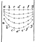
Fig. 16.
But in August, 1841, the distinguished Swiss investigator had invited Professor J. D. Forbes, of Edinburgh, to interest himself in solving the problem of glacial motion. In response to this request, Professor Forbes spent three weeks with Agassiz upon the Aar Glacier. Stimulated by the interest of this visit, Forbes returned to Switzerland in 1842 and began a series of independent investigations upon the Mer de Glace. After a week’s observations with accurate instruments, Forbes wrote to Professor Jameson, editor of the Edinburgh New Philosophical Journal, that he had already made it certain that “the central part of the glacier moves faster than the edges in a very considerable proportion, quite contrary to the opinion generally maintained.” This letter was dated July 4, 1842, but was not published until the October following, Agassiz’s results, so far as then determined, were, however, published in Comptes Rendus of the 29th of August, 1842, two months before the publication of Forbes’s letter. But Agassiz’s letter was dated twenty-seven days later than that of Forbes. It becomes certain, therefore, that both Agassiz and Forbes, independently and about the same time, discovered the fact that the central portion of a glacier moves more rapidly than the sides.
In 1857 Professor Tyndall began his systematic and fruitful observations upon the Mer de Glace and other Alpine glaciers. Professor Forbes had already demonstrated that, with an accurate instrument of observation, the motion of a line of stakes might be observed after the lapse of a single clay, or even of a few hours. As a result of Tyndall’s observations, it was found that the most rapid daily motion in the Mer de Glace in 1857 was about thirty-seven inches. This amount of motion was near the lower end of the glacier On ascending the glacier, the rate was found in general to be diminished; but the diminution was not uniform throughout the whole distance, being affected both by the size and by the contour of the valley. The motion in the tributary glaciers was also much less than that of the main glacier.
This diminution of movement in the tributary glaciers was somewhat proportionate to their increase in width. For example, the combined width of the three tributaries uniting to form the Mer de Glace is 2,597 yards; but a short distance below the junction of these tributaries the total width of the Mer de Glace itself is only 893 yards, or one-third that of the tributaries combined. Yet, though the depth of the ice is probably here much greater than in the tributaries, the rapidity of movement is between two and three times as great as that of any one of the branches.[AM]
From Tyndall’s observations it appears also that the line of most rapid motion is not exactly in the middle of the channel, but is pushed by its own momentum from one side to the other of the middle, so as always to be nearer the concave side; in this respect conforming, as far as its nature will permit, to the motion of water in a tortuous channel.
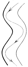
Fig. 17.
It is easy to account for this differential motion upon the surface of a glacier, since it is clear that the friction of the sides of the channel must retard the motion of ice as it does that of water. It is clear also that the friction of the bottom must retard the motion of ice even more than it is known to do in the case of water. In the formation of breakers, when the waves roll in upon a shallowing beach, every one is familiar with the effect of the bottom upon the moving mass. Here friction retards the lower strata of water, and the upper strata slide over the lower, and, where the water is of sufficient depth and the motion is sufficiently great, the crest breaks down in foam before the ever-advancing tide. A similar phenomenon occurs when dams give way and reservoirs suddenly pour their contents into the restricted channels below. At such times the advancing water rolls onwards like the surf with a perpendicular front, varying in height according to the extent of the flood.
Seasoning from these phenomena connected with moving water, it was naturally suggested to Professor Tyndall that an analogous movement must take place in a glacier. Choosing, therefore, a favourable place for observation on the Mer de Glace where the ice emerged from a gorge, he found a perpendicular side about one hundred and fifty feet in height from bottom to top. In this face he drove stakes in a perpendicular line from top to bottom. Upon subsequently observing them, Tyndall found, as he expected, that there was a differential motion among them as in the stakes upon the surface. The retarding effect of friction upon the bottom was evident. The stake near the top moved forwards about three times as fast as the one which was only four feet from the bottom.
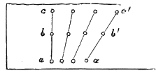
Fig. 18.
The most rapid motion (thirty-seven inches per day) observed by Professor Tyndall upon the Alpine glaciers occurred in midsummer. In winter the rate was only about one-half as great; but in the year 1875 the Norwegian geologist, Helland, reported a movement of twenty metres (about sixty-five feet) per day in the Jakobshavn Glacier which enters Disco Bay, Greenland, about latitude 70°. For some time there was a disposition on the part of many scientific men to doubt the correctness of Holland’s calculations. Subsequent observations have shown, however, that from the comparatively insignificant glaciers of the Alps they were not justified in drawing inferences with respect to the motion of the vastly larger masses which come down to the sea through the fiords of Greenland. The Jakobshavn Glacier was about two and a half miles in width and its depth very likely more than a thousand feet, making a cross-section of more than 1,400,000 square yards, whereas the cross-section of the Mer de Glace at Montanvert is estimated to be but 190,000 square yards or only about one-seventh the above estimate for the Greenland glacier. As the friction of the sides would be no greater upon a large stream than upon a small one, while upon the bottom it would be only in proportion to the area, it is evident that we cannot tell beforehand how rapidly an increase in the volume of the ice might augment the velocity of the glacier.
At any rate, all reasonable grounds for distrusting the accuracy of Helland’s estimates seem to have been removed by later investigations. According to my own observations in the summer of 1886 upon the Muir Glacier, Alaska, the central portions, a mile back from the front of that vast ice-current, were moving from sixty-five to seventy feet per day. These observations were taken with a sextant upon pinnacles of ice recognizable from a baseline established upon the shore. It is fair to add, however, that during the summer of 1890 Professor H. F. Reid attempted to measure the motion of the same glacier by methods promising greater accuracy than could be obtained by mine. He endeavoured to plant, after the method of Tyndall, a line of stakes across the ice-current. But with his utmost efforts, working inwards from both sides, he was unable to accomplish his purpose, and so left unmeasured a quarter of a mile or more of the most rapidly-moving portion of the glacier. His results, therefore, of ten feet per day in the most rapidly-moving portion observed cannot discredit my own observations on a portion of the stream inaccessible by his method. A quarter of a mile in width near the centre of so vast a glacier gives ample opportunity for a much greater rate of motion than that observed by Professor Reid. Especially may this be true in view of Tyndall’s suggestion that the contour of the bottom over which the ice flows may greatly affect the rate in certain places. A sudden deepening of the channel may affect the motion of ice in a glacier as much as it does that of water in a river.
Other observations also amply sustain the conclusions of Helland. As already stated, the Danish surveying party under Steenstrup, after several years’ work upon the southwestern coast of Greenland, have ascertained that the numerous glaciers coming down to the sea in that region and furnishing the icebergs incessantly floating down Baffin’s Bay, move at a rate of from thirty to fifty feet per day, while Lieutenants Ryder and Bloch, of the Danish Navy, who spent the year 1887 in exploring the coast in the vicinity of Upernavik, about latitude 73°, found that the great glacier entering the fiord east of the village had a velocity of ninety-nine feet per day during the month of August.[AN]
It is easier to establish the fact of glacial motion than to explain how the motion takes place, for ice seems to be as brittle as glass. This, however, is true of it only when compelled suddenly to change its form. When subjected to slow and long-continued pressure it gradually yet readily yields, and takes on new forms. From this capacity of ice, it has come to be regarded by some as a really viscous substance, like tar or cooling lava, and upon that theory Professor Forbes endeavours to explain all glacial movement.
The theory, however, seems to be contradicted by familiar facts; for the iceman, after sawing a shallow groove across a piece of ice, can then split it as easily as he would a piece of sandstone or wood. On the glaciers themselves, likewise, the existence of innumerable crevasses would seem to contradict the plastic theory of glacier motion; for, wherever the slope of the glacier’s bed increases, crevasses are formed by the increased strain to which the ice is subjected. Crevasses are also formed in rapidly-moving glaciers by the slight strain occasioned by the more rapid motion of the middle portion. Still, in the words of Tyndall, “it is undoubted that the glacier moves like a viscous body. The centre flows past the sides, the top flows over the bottom, and the motion through a curved valley corresponds to fluid motion.”[AO]
To explain this combination of the seemingly contradictory qualities of brittleness and viscosity in ice, physicists have directed attention to the remarkable transformations which take place in water at the freezing-point. Faraday discovered in 1850 that "when two pieces of thawing ice are placed together they freeze together at the point of contact.[AP]
“Place a number of fragments of ice in a basin of water and cause them to touch each other; they freeze together where they touch. You can form a chain of such fragments; and then, by taking hold of one end of the chain, you can draw the whole series after it. Chains of icebergs are sometimes formed in this way in the arctic seas.”[AQ]
This is really what takes place when a hard snow-ball is made by pressure in the hand. So, by subjecting fragments of ice to pressure it is first crumbled to powder, and then, as the particles are pressed together in close contact, it resumes the nature of ice again, though in a different form, taking now the shape of the mould in which it has been pressed.
Thus it is supposed that, when the temperature of ice is near the melting-point, the pressure of the superincumbent mass may produce at certain points insensible disintegration, while, upon the removal of the pressure by change of position, regulation instantly takes place, and thus the phenomena which simulate plasticity are produced. As the freezing-point of water is, within a narrow range, determined by the amount of pressure to which it is subjected, it is not difficult to see how these changes may occur. Pressure slightly lowers the freezing-point, and so would liquefy the portions of ice subjected to greatest pressure, wherever that might be in the mass of the glacier, and thus permit a momentary movement of the particles, until they should recongeal in adjusting themselves to spaces of less pressure.[AR] This is the theory by which Professor James Thompson would account for the apparent plasticity of glacial ice.
CHAPTER IV.
SIGNS OF PAST GLACIATION.
The facts from which we draw the inference that vast areas of the earth’s surface which are now free from glaciers were, at a comparatively recent time, covered with them, are fourfold, and are everywhere open to inspection. These facts are: 1. Scratches upon the rocks. 2. Extensive unstratified deposits of clay and sand intermingled with scratched stones and loose fragments of rock. 3. Transported boulders left in such positions and of such size as to preclude the sufficiency of water-carriage to account for them. 4. Extensive gravel terraces bordering the valleys which emerge from the glaciated areas. We will consider these in their order:
1. The scratches upon the rocks.
Almost anywhere in the region designated as having been covered with ice during the Glacial period, the surface of the rocks when freshly uncovered will be found to be peculiarly marked by grooves and scratches more or less fine, and such as could not be produced by the action of water. But, when we consider the nature of a glacier, these marks seem to be just what would be produced by the pushing or dragging along of boulders, pebbles, gravel, and particles of sand underneath a moving mass of ice.
Running water does indeed move gravel, pebbles, and boulders along with the current, but these objects are not held by it in a firm grasp, such as is required to make a groove or scratch in the rock. If, also, there are inequalities in the compactness or hardness of the rock, the natural action of running water is to hollow out the soft parts, and leave the harder parts projecting. But, in the phenomena which we are attributing to glacial action, there has been a movement which has steadily planed down the surface of the underlying rock; polishing it, indeed, but also grooving it and scratching it in a manner which could be accomplished only by firmly held graving-tools.
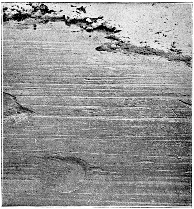
Fig. 19.—Bed-rock scored with glacial marks, near Amherst, Ohio. (From a photograph by Chamberlin.)
This polishing and scratching can indeed be produced by various agencies; as, for example, by the forces which fracture the earth’s crust, and shove one portion past another, producing what is called a slicken-side. Or, again, avalanches or land-slides might be competent to produce the results over limited and peculiarly situated areas. Icebergs, also, and shore ice which is moved backwards and forwards by the waves, would produce a certain amount of such grooving and scratching. But the phenomena to which we refer are so extensive, and occur in such a variety of situations, that the movement of glacial ice is alone sufficient to afford a satisfactory explanation. Moreover, in Alaska, Greenland, Norway, and Switzerland, and wherever else there are living glaciers, it is possible to follow up these grooved and striated surfaces till they disappear underneath the existing glaciers which are now producing the phenomena. Thus by its tracks we can, as it were, follow this monster to its lair with as great certainty as we could any animal with whose footprints we had become familiar.
2. The till, or boulder-clay.
A second sign of the former existence of glaciers over any area consists of an unstratified deposit of earthy material, of greater or less depth, in which scratched pebbles and fragments of rock occur without any definite arrangement.
Moving water is a most perfect sieve. During floods, a river shoves along over its bed gravel and pebbles of considerable size, whereas in time of low-water the current may be so gentle as to transport nothing but fine sand, and the clay will be carried still farther onwards, to settle in the still water and form a delta about the river’s mouth. The transporting capacity of running water is in direct ratio to the sixth power of its velocity. Other things being equal, if the velocity be doubled, the size of the grains of sand or gravel which it transports is increased sixty-four fold.[AS] So frequent are the changes in the velocity of running water, that the stratification of its deposits is almost necessary and universal. If large fragments of rocks or boulders are found embedded in stratified clay, it is pretty surely a sign that they have been carried to their position by floating ice. A small mountain stream with great velocity may move a good-sized boulder, while the Amazon, with its mighty but slow-moving current, would pass by it forever without stirring it from its position. But the vast area which is marked in our map as having been covered with ice during the Glacial period is characterised by deep and extensive deposits of loose material devoid of stratification, and composed of soil and rock gathered in considerable part from other localities, and mixed in an indiscriminate mass with material which has originated in the disintegration of the underlying local strata.
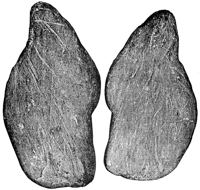
Fig. 20.—Scratched stone from the till of Boston. Natural size about one foot and a half long by ten inches wide. (From photograph.)
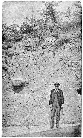
Fig. 21.—Typical section of till in Seattle. Washington State, about two hundred feet above Puget Sound. This is on the height between the sound and Lake Washington.

Fig. 22.—Ideal section, showing how the till overlies the stratified rocks.
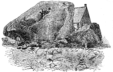
Fig. 23.—Vessel Rock, a glacial boulder in Gilsum. N. H. (C. H. Hitchcock.)
3. Transported boulders.
Where there is a current of water deep enough to float large masses of ice, there is scarcely any limit to the size of boulders which may be transported upon them, or to the distance to which the boulders may be carried and dropped upon the bottom. The icebergs which break off from the glaciers of Greenland may bear their burdens of rock far down into the Atlantic, depositing them finally amidst the calcareous ooze and the fine sediment from the Gulf Stream which is slowly covering the area between Northern America and Europe. Northern streams like the St. Lawrence, which are deeply frozen over with ice in the winter, and are heavily flooded as the ice breaks up in the spring, afford opportunity for much transportation of boulders in the direction of their current. In attributing the transportation of a boulder to glacial ice, it is necessary, therefore, to examine the contour of the country, so as to eliminate from the problem the possibility of the effects having been produced by floating ice.
Another source of error against which one has to be on his guard arises from the close resemblance of boulders resulting from disintegration to those which have been transported by ice from distant places. Owing to the fact that large masses of rocks, especially those which are crystalline, are seldom homogeneous in their structure, it results that, under the slow action of disintegrating and erosive agencies, the softer parts often are completely removed before the harder nodules are sensibly affected, and these may remain as a collection of boulders dotting the surface. Such boulders are frequent in the granitic regions of North Carolina and vicinity, where there has been no glacial transportation. Several localities in Pennsylvania, also, south of the line of glacial action as delineated by Professor Lewis and myself, had previously been supposed to contain transported boulders of large size, but on examination they proved in all cases to be resting upon undisturbed strata of the parent rock, and were evidently the harder portions of the rock left in loco by the processes of erosion spoken of. In New England, also, it is possible that some boulders heretofore attributed to ice-action may be simply the results of these processes of disintegration and erosion. Whether they are or not can usually be determined by their likeness or unlikeness to the rocks on which they rest; but oftentimes, where a particular variety of rock is exposed over a broad area, it is difficult to tell whether a boulder has suffered any extensive transportation or not.
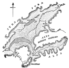
Fig. 24.—Map showing the outline and course of flow of the great Rhône Glacier (after Lyell). Click on image to view larger sized.
One of the most interesting and satisfactory demonstrations of the distribution of boulders by glacial ice was furnished by Guyot in Switzerland in 1845. His observations and argument will be most readily understood by reference to the accompanying map, taken from Lyell’s clear description.[AT] The Jura Mountains are separated from the Alps by a valley, about eighty miles in width, which constitutes the main habitable portion of Switzerland, and they rise upwards of two thousand feet above it. But large Alpine boulders are found as high as two thousand feet above the Lake Neufchâtel upon the flanks of the Jura Mountains beyond Chasseron (at the point marked G on the map), and the whole valley is dotted with Alpine boulders. Upon comparing these with the native rocks in the Alps, Guyot in many cases was able to determine the exact centres from which they were distributed, and the distribution is such as to demonstrate that glacial ice was the medium of distribution.
For example, the dotted lines upon the map indicate the motion of the transporting medium. On ascending the valley of the Rhône to A, the diminutive representative of the ancient glacier is still found in existence, and is at work transporting boulders and moraines according to the law of ice-movement. Following down the valley from A, boulders from the head of the Rhône Valley are found distributed as far as B at Martigny, where the valley turns at right angles towards the north. It is evident that floating ice in a stream of water would by its momentum be carried to the left bank, so that if icebergs were the medium of transportation we should expect to find the boulders from the right-hand side of the Rhône Valley distributed towards the left end of the great valley of Switzerland—that is, in the direction of Geneva. But, instead, the boulders derived from C, D, and E, on the Bernese Oberland side, instead of crossing the valley at B, continue to keep on the right-hand side and are distributed over the main valley in the direction of the river Aar.
As is to be expected also, the direct northward motion of the ice from B is stronger than the lateral movement to the right and left after it emerges from the mouth of the Rhône Valley, at F, and consequently it has pushed forwards in a straight line, so as to raise the Alpine boulders to a greater height upon the Jura Mountains at G than anywhere else, the upper limit of boulders at G being 1,500 feet higher than the limits at I or K on the left and right, points distant about one hundred miles from each other. All the boulders to the right of the line from B to G have been derived from the right side of the Rhône, while all the boulders to the left of that line have been derived from its left side.
A boulder of talcose granite containing 61,000 French cubic feet, measuring about forty feet in one direction, came, according to Charpentier, from the point n, near the head of the Rhône Valley, and must have travelled one hundred and fifty miles to reach its present position.
It scarcely needs to be added that the grooves and scratches upon the rocks over the floor of this great valley of Switzerland indicate a direction of the ice-movement corresponding to that implied in the distribution of boulders. Thus, at K upon the map referred to, Lyell reports that the abundant grooves and striæ upon the polished marble all trend down the valley of the Aar.[AU]
Similar facts concerning the transportation of boulders have been observed at Trogen, in Appenzel, where boulders derived from Trons, one hundred miles distant, are found to keep upon the left bank of the Rhine, however much the valley may wind about; and in some places, as at Mayenfeld, it turns almost at right angles, as did the Rhône at Martigny. Upon reaching the lower country at Lake Constance, these granite blocks from the left side of the valley deploy out upon the same side and do not cross over, as they would inevitably have done had they been borne along by currents of water.
In America Ave do not have quite so easy a field as is presented in Switzerland for the discovery of crucial instances showing that boulders have been transported by glacial ice rather than by floating ice, for in Switzerland the glaciated area is comparatively small and the diminutive remnants of former glaciers are still in existence, furnishing a comprehensive object-lesson of great interest and convincing power. Still, it is not difficult to find decisive instances of glacial transportation even in the broad fields of America which now retain no living remnants of the great continental ice-sheet.
As every one who resides in or who visits New England knows, boulders are scattered freely over all parts of that region, but for a long time the theory suggested to account for their distribution was that of floating ice during a period of submergence. One of the most convincing evidences that the boulders were distributed by glacial ice rather than by icebergs is found in Professor C. H. Hitchcock’s discovery of boulders on the summit of Mount Washington (over 6,000 feet above the sea), which he was able to identify as derived from the ledges of light grey Bethlehem gneiss, whose nearest outcrop is in Jefferson, several miles to the northwest, and 3,000 or 4,000 feet lower than Mount Washington. However difficult it may be to explain the movement of these boulders by glacial ice, it is not impossible to do so, but the attempt to account for their transportation by floating ice is utterly preposterous. No iceberg could pick up boulders so far beneath the surface of the water, and even if it could advance thus far in its work it could not by any possibility land them afterwards upon the summit of Mount Washington.
Among the most impressive instances of boulders evidently transported by glacial ice, rather than by icebergs, were some which came to my notice when, in company with the late Professor H. Carvill Lewis, I was tracing the glacial boundary across the State of Pennsylvania. We had reached the elevated plateau (two thousand feet above the sea) which extends westwards and southwards from the peak of Pocono Mountain, in Monroe County. This plateau consists of level strata of sandstone, the southern part of which is characterised by a thin sandy soil, such as is naturally formed by the disintegration of the underlying rock, and there is no foreign material to be found in it. But, on going northwards to the boundary of Tobyhanna township, we at once struck a large line of accumulations, stretching from east to west, and rising to a height of seventy or eighty feet. This was chiefly an accumulation of transported boulders, resembling in its structure the terminal moraines which are found at the front of glaciers in the Alps and in Alaska, and indeed wherever active glaciers still remain. But here we were upon the summit of the mountain, where there are no higher levels to the north of us, down which the ice could flow. Besides, among these boulders we readily recognised many of granite, which must have come either from the Adirondack Mountains, two hundred miles to the north, or from the Canadian highlands, still farther away.
Limiting our observations simply to the boulders, we should indeed have been at liberty to suppose that they had been transported across the valley of the Mohawk or of the Great Lakes by floating ice during a period of submergence. But we were forbidden to resort to this hypothesis by the abrupt marginal line, running east and west, upon Pocono plateau, along which these northern boulders ceased. South of this evident terminal moraine there was no barrier, and there were no northern boulders. On the theory of submergence, there was no reason for the boundary-line so clearly manifested. Ice which had floated so far would have floated farther.
Still further, on going a few miles east of the Pocono plateau, one descends into a parallel valley, lying between Pocono Mountain and Blue Mountain, and one thousand feet below their level. But our marginal southern boundary of transported granite rocks did not extend much farther south in the valley than it did on the plateau, except where we could trace the action of a running stream, evidently corresponding to the subglacial rivers which pour forth from the front of every extensive glacier. In these facts, therefore, we had a crucial test of the glacial hypothesis, and, in view of them, could maintain, against all objectors, the theory of the distant glacial transportation of boulders, even over vast areas of the North American continent.
Since that experience, I have traced this limit of southern boulders for thousands of miles across the continent, according to the delineation which may be seen in the map in a later chapter. If necessary, I could indicate hundreds of places where the proof of glacial transportation is almost as clear as that on the Pocono plateau in Pennsylvania. One of the most interesting of these is on the hills in Kentucky, about twelve miles south of the Ohio River, at Cincinnati, where I discovered boulders of a conglomerate containing many pebbles of red jasper, which can be identified as from a limited formation cropping out in Canada, to the north of Lake Huron, six hundred or seven hundred miles distant. That this was transported by glacial ice, and not by floating ice, is evident from the fact that here, too, there was no barrier to the south, requiring deposits to cease at that point, and from the further fact that boulders of this material are found in increasing frequency all the way from Kentucky to the parent ledges in Canada. With reference to these boulders, as with reference to those found on the summit of Mount Washington, we can reason, also, that any northerly subsidence permitting a body of water to occupy the space between Kentucky and Lake Superior, and deep enough to facilitate the movement across it of floating ice, would render it impossible for the ice to have loaded itself with them.
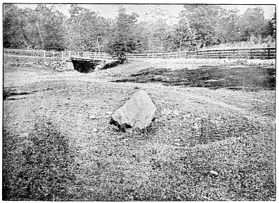
Fig. 25.—Conglomerate boulder found in Boone County, Kentucky. (See text.)
The same line of reasoning is conclusive respecting the innumerable boulders which cover the northern portion of Ohio, where I have my residence. The whole State of Ohio, and indeed almost the entire Mississippi basin between the Appalachian and the Rocky Mountains, is completely covered, and to a great depth, with stratified rocks which have been but slightly disturbed in the elevation of the continent; yet, down to an irregular border-line running east and west, granitic boulders everywhere occur in great numbers. In the locality spoken of in northern Ohio the elevation of the country is from two hundred to five hundred feet above the level of Lake Erie. The nearest outcrops of granitic rock occur about four hundred miles to the north, in Canada. After the meeting of the American Association for the Advancement of Science in Toronto in the summer of 1889, I had the privilege of joining a company of geologists in an excursion, conducted by members of the Canadian Survey, to visit the region beyond Lake Nipissing, north of Lake Huron, where the ancient Laurentian and Huronian rocks are most typically developed. I took advantage of the trip to collect specimens of a great variety of the granites and gneisses and metamorphic schists and trap-rock of the region. On bringing them home I turned them over to the professor of geology, who at once set his class at work to see if they could match my fragments from Canada with corresponding fragments from the boulders of the vicinity. To the great gratification, both of the pupils and myself, they were able to do so in almost every case; and so they might have done in any county or township to the south until reaching the limit of glacier action which I had previously mapped. Here, at Oberlin, on the north side of the water-shed, it is possible to imagine that we are on the southern border of an ancient lake upon whose bosom floating ice had brought these objects from their distant home in Canada. But this theory would not apply to the portion of the State which is south of the water-shed and which slopes rapidly towards the Gulf of Mexico. Yet the distribution of boulders is practically uniform over the glaciated area on both sides of the water-shed, constituting thus an indisputable proof of the glacial theory.
4th. As the significance of the gravel terraces which mark the lines of outward drainage from the glaciated area cannot well be indicated in a single paragraph, the reader is referred for further information upon this point to the general statements respecting them throughout the next chapter.
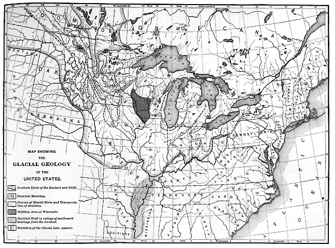
Click on map to view larger sized.
CHAPTER V.
ANCIENT GLACIERS IN THE WESTERN HEMISPHERE.
New England.
In North America all the indubitable signs of glacial action are found over the entire area of New England, the southern coast being bordered by a double line of terminal moraines. The outermost of these appears in Nantucket, Martha’s Vineyard, No Man’s Land, Block Island, and through the entire length of Long Island—from Montauk Point, through the centre of the island, to Brooklyn, N. Y., and thence across Staten Island to Perth Amboy in New Jersey. The interior line is nearly parallel with the outer, and, beginning at the east end of Cape Cod, runs in a westerly direction to Falmouth, and thence southwesterly through Wood’s Holl, and the Elizabeth Islands—these being, indeed, but the unsubmerged portions of the moraine. On the mainland this interior line reappears near Point Judith, on the south shore of Rhode Island, and, running slightly south of west, serves to give character to the scenery at Watch Hill, and thence crops out in the Sound as Fisher and Plum Islands, and farther west forms the northern shore of Long Island to Port Jefferson.
In these accumulations bordering the southern shore of New England, the characteristic marks of glacial action can readily be detected even by the casual observer, and prolonged examination will amply confirm the first impression. The material of which they are composed is, for the most part, foreign to the localities, and can be traced to outcrops of rock at the north. The boulders scattered over the surface of Long Island, for example, consist largely of granite, gneiss, hornblende, mica slate, and red sandstone, which are easily recognised as fragments from well-known quarries in Connecticut, Rhode Island, and Massachusetts; yet they have been transported bodily across Long Island Sound, and deposited in a heterogeneous mass through the entire length of the island. Not only do they lie upon the surface, but, in digging into the lines of hills which constitute the backbone of Long Island, these transported boulders are found often to make up a large part of the accumulation. Almost any of the railroad excavations in the city of Brooklyn present an interesting object-lesson respecting the composition of a terminal moraine.
All these things are true also of the lines of moraine farther east, as just described. Professor Shaler has traced to its source a belt of boulders occurring extensively over southern Rhode Island, and found that they have spread out pretty evenly over a triangular area to the southward, in accordance with the natural course to be pursued by an ice-movement. Nearly all of Plymouth County, in southeastern Massachusetts, is composed of foreign material, much of which can be traced to the hills and mountains to the north. Even Plymouth Rock is a boulder from the direction of Boston, and the “rock-bound” shores upon which the Pilgrims are poetically conceived to have landed are known, in scientific prose, as piles of glacial rubbish dumped into the edge of the sea by the great continental ice-sheet.
The whole area of southeastern Massachusetts is dotted with conical knolls of sand, gravel, and boulders, separated by circular masses of peat or ponds of water, whose origin and arrangement can be accounted for only by the peculiar agency of a decaying ice-front. Indeed, this whole line of moraines, from the end of Cape Cod to Brooklyn, N. Y., consists of a reticulated network of ridges and knolls, so deposited by the ice as to form innumerable kettle-holes which are filled with water where other conditions are favourable. Those which are dry are so because of their elevation above the general level, and of the looseness of the surrounding soil; while many have been filled with a growth of peat, so that their original character as lakelets is disguised.
As already described, these depressions, so characteristic of the glaciated region, are, in the majority of cases, supposed to have originated by the deposition of a great quantity of earthy material around and upon the masses of ice belonging to the receding front of the glacier, so that, when at length the ice melted away, a permanent depression in the soil was left, without any outlet.
To some extent, however, the kettle-holes may have been formed by the irregular deposition of streams of water whose courses have crossed each other, or where eddies of considerable force have been produced in any way. The ordinary formation of kettle-holes can be observed in progress on the foot of almost any glacier, or, indeed, on a small scale, during the melting away of almost any winter’s snow. Where, from any cause, a stratum of dirt has accumulated upon a mass of compact snow or ice, it will be found to settle down in an irregular manner; furrows will be formed in various directions by currents of water, so that the melting will proceed irregularly, and produce upon a miniature scale exactly what I have seen on a large scale over whole square miles of the decaying foot of the great Muir Glacier in Alaska. The effects of similar causes and conditions we can see on a most enormous scale in the ten thousand lakes and ponds and peat-bogs of the whole glaciated area both in North America and in Europe.
In addition to these two lines of evidence of glacial action in New England, we should mention also the innumerable glacial grooves and scratches upon the rocks which can be found on almost any freshly uncovered surface. In New England the direction of these grooves is ordinarily a little east of south. Upon the east coast of Massachusetts and New Hampshire the scratches trend much more to the east than they do over most of the interior. This is as it should be on the glacial theory, since the ice would naturally move outwards in the line of least resistance, which would, of course, be towards the open sea wherever that is near. In the interior of New England the scratches upon the rocks indicate a more southerly movement in the Connecticut Valley than upon the mountains in the western part of Massachusetts. This also is as it should be upon the glacial theory. The scratches upon the mountains were made when the ice was at its greatest depth and when it moved over the country in comparative disregard of minor irregularities of surface, while in the valleys, at least in the later portion of the Ice age, the movement would be obstructed except in one direction. In the interpretation of the glacial grooves and scratches it should be borne in mind that they often represent the work done during the closing stages of the period. Just as the last shove of the carpenter’s plane removes the marks of the previous work, so the last rasping of a glacial movement wears away the surfaces which have been previously polished and striated.
In various places of New England it is interesting as well as instructive to trace the direction of the ice-movement by the distribution of boulders. My own attention was early attracted to numerous fragments of gneiss in eastern Massachusetts containing beautiful crystals of feldspar, which proved to be peculiar to the region of Lake Winnepesaukee, a hundred miles to the north, and to a narrow belt stretching thence to the southwestward. In ascending almost any of the lower summits of the White Mountains one’s attention can scarcely fail of being directed to the difference between the material of which the mountains are composed and that of the numerous boulders which lie scattered over the surface. The local geologist readily recognises these boulders as pilgrims that have wandered far from their homes to the northward.
Trains of boulders, such as those already described in Rhode Island, can frequently be traced to some prominent outcrop of the rock in a hill or mountain-peak from which they have been derived. One of the earliest of these to attract attention occurs in the towns of Richmond, Lenox, and Stockbridge, in the western part of Massachusetts. Here a belt of peculiar boulders about four hundred feet wide is found to originate in the town of Lebanon, N. Y., and to run continuously to the southeast for a distance of nine miles. West of Fry’s Hill, where the outcrop occurs, no boulders of this variety of rock are to be found, while to the southeast the boulders gradually diminish in size as their distance from the outcrop increases. Near the outcrop boulders of thirty feet in diameter occur, while nine miles away two feet is the largest diameter observed.
Sir Charles Lyell endeavoured to explain this train of boulders by the action of icebergs during a period of submergence—supposing that, as icebergs floated past or away from this hill in Lebanon, N. Y., they were the means of the regular distribution described. It is needless to repeat the difficulties arising in connection with such a theory, since now both by observation and experiment we have become more familiar with the movement of glacial ice. What we have already said about the transportation of boulders over Switzerland by the Alpine glaciers, and what is open to observation at the present time upon the large glaciers of Alaska, closely agree with the facts concerning this Richmond train of boulders, and we have no occasion to look further for a cause.
Indeed, trains of boulders ought to appear almost everywhere over the glaciated area; and so they do where all the circumstances are favourable. But, readily to identify the train, requires that to furnish the boulders there should be in the line of the ice-movement a projecting mass of rock hard enough to offer considerable resistance to the abrading agency of the ice and characteristic enough in its composition to be readily recognised. Ship Rock, in Peabody, Mass., weighing about eleven hundred tons, and Mohegan Rock, in Montville, Conn., weighing about ten thousand tons, have ordinarily been pointed to as boulders illustrating the power of ice-action. Their glacial character, however, has been challenged from the fact that the variety of granite to which they belong occurs in the neighbourhood, and indeed constitutes the bed-rock upon which they rest.[AV] Some would therefore consider them, like some of which we have already spoken, to be boulders which have originated through the disintegration of great masses of rock, of which these were harder nuclei that have longer resisted the ravages of the tooth of time. It must be admitted that possibly this explanation is correct; but it is scarcely probable that, in a region where there are so many other evidences of glacial action, these boulders could have remained immovable in presence of the onward progress of the ice-current that certainly passed over them.
However, as already seen, we are not left to doubt as to the movement of some boulders of great size. That which now claims the reputation of being the largest in New England is in Madison, N. H., and measures thirty by forty by seventy-five feet. This can be traced to ledges of Conway granite, about two miles away.[AW] Many boulders in the vicinity of New Haven, Conn., can be identified, as from well-known trap-dykes, sixteen miles or more to the north. The so-called Judge’s Cave, on West Rock, 365 feet above the adjoining valley and weighing a thousand tons, is one of these. Professor Edward Orton[AX] describes a mass of Clinton limestone near Freeport, Warren County, Ohio, as covering an area of three-fourths of an acre, and as sixteen feet in thickness. It overlies glacial clays and gravels, and must have been transported bodily from the elevations containing this rock several miles to the northwest.
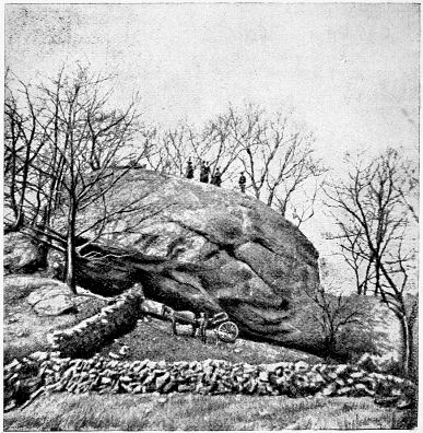
Fig. 26.—Mohegan Rock.
Portions of New England present the best illustrations anywhere afforded in America of what are called “drumlins.” These are “lenticular-shaped” hills, composed of till, and containing, interspersed through their mass, numerous scratched stones of all sizes. They vary in length from a few hundred feet to a mile, and are usually from half to two-thirds as wide as they are long. In height they vary from twenty-five to two hundred feet.
But, according to the description of Mr. Upham, whatever may be their size and height, they are singularly alike in outline and form, usually having steep sides, with gently sloping, rounded tops, and presenting a very smooth and regular contour. From this resemblance in shape to an elliptical convex lens, Professor Hitchcock has called them lenticular hills to distinguish these deposits of till from the broadly flattened or undulating sheets which are common throughout New England.
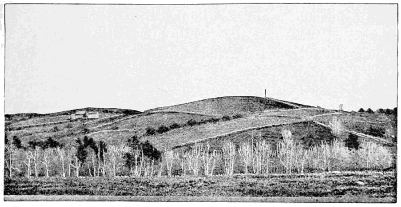
Fig. 27.—Drumlins in Goffstown, N. H. (Hitchcock).
The trend, or direction of the longer axis, of these lenticular hills is nearly the same for all of them comprised within any limited area, and is approximately like the course of the striæ or glacial furrows marked upon the neighbouring ledges. In eastern Massachusetts and New Hampshire, within twenty-five miles of the coast, it is quite uniformly to the southeast, or east-southeast. Farther inland, in both of these States, it is generally from north to south, or a few degrees east of south; while in the valley of the Connecticut River it is frequently a little to the west of south. In New Hampshire, besides its accumulation in these hills, the till is frequently amassed in slopes of similar lenticular form. These have their position almost invariably upon either the south or north side of the ledgy hills against which they rest, showing a considerable deflection towards the southeast and northwest in the east part of the State. It cannot be doubted that the trend of the lenticular hills, and the direction taken by these slopes, have been determined by the glacial current, which produced the striæ with which they are parallel.[AY]
Drumlins are abundant in the vicinity of Boston, and constitute nearly all the islands in Boston Harbour. On the mainland, Beacon Hill, Bunker Hill, Green Hill, Powderhorn Hill, Tufts College Hill, Winter Hill, Mount Ida, Corey Hill, Parker Hill, Wollaston Heights, Prospect Hill, and Telegraph Hill are specimens.
The northeastern corner of Massachusetts and the southeastern corner of New Hampshire are largely covered with these peculiar-shaped glacial deposits, while they are numerous as far west as Fitchburg, in Massachusetts, and Ware, N. H., and in the northeastern part of Connecticut. A little later, also, we shall refer to an interesting line of them in central New York. Elsewhere in America, except in a portion of Wisconsin, they rarely occur in such fine development as in New England. In Europe they are best developed in portions of Ireland.
One’s first impression in examining an exposed section of a drumlin would lead him to think that the mass was entirely unstratified; but closer examination shows that there is a coarse stratification, but evidently not produced by water-action. The accumulation has probably taken place gradually by successive deposits underneath the glacier itself. Professor William M. Davis has suggested a plausible explanation which we will briefly state.
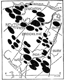
Fig. 28.—Drumlins in the vicinity of Boston (Davis).
The frequency with which drumlins are found to rest upon a mass of projecting rock, the general co-ordination of the direction of their axes with the direction of the scratches upon the underlying rock, and the abundance of scratched stones in them, all support the theory that drumlins are formed underneath the ice-sheet, somewhat in the way that islands and bars of silt are formed in the delta of a great river. The movement of ice seems to have been concentrated in pretty definite lines, often determined by the contour of the bottom, leaving a slacker movement in intervening areas, which were evidently protected in some cases by projecting masses of rock. In these areas of slower movement there was naturally an accumulation at the same time that there was vigorous erosion in the lines of more rapid movement.
There was doubtless a continual transfer of material from the end of the drumlin which abutted against the moving mass of ice to the lower end, as there is in the formation of an island in a river. If time enough had elapsed, the whole accumulation would have been levelled by the glacier and spread over the broader area where the more rapid lines of movement became confluent, and where the differential motion was less marked. Drumlins are thus characteristic of areas in the glaciated region whose floor was originally only moderately irregular, and where there was an excessive amount of ground-moraine to be transported, and where the movement did not continue indefinitely. It has been suggested, also, that some of the long belts of territory in New England and central New York covered by drumlins may represent old terminal moraines which were subsequently surmounted by a readvance of the ice, and partially wrought over into their present shape.
It is in New England, also, that kames are to be found in better development than anywhere else in America. These interesting remnants of the Glacial age are clearly described by Mr. James Geikie. His account will serve as well for New England as for Scotland.
The sands and gravels have a tendency to shape themselves into mounds and winding ridges, which give a hummocky and rapidly undulating outline to the ground. Indeed, so characteristic is this appearance, that by it alone we are often able to mark out the boundaries of the deposits with as much precision as we could were all the vegetation and soil stripped away and the various subsoils laid bare. Occasionally, ridges may be tracked continuously for several miles, running like great artificial ramparts across the country. These vary in breadth and height, some of the more conspicuous ones being upward of four or five hundred feet broad at the base, and sloping upward at an angle of twenty-five or even thirty-five degrees, to a height of sixty feet and more above the general surface of the ground. It is most common, however, to find mounds and ridges confusedly intermingled, crossing and recrossing each other at all angles, so as to enclose deep hollows and pits between. Seen from some dominant point, such an assemblage of kames, as they are called, looks like a tumbled sea—the ground now swelling into long undulations, now rising suddenly into beautiful peaks and cones, and anon curving up in sharp ridges that often wheel suddenly round so as to enclose a lakelet of bright clear water.[AZ]
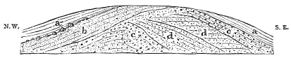
Fig. 29.—Section of kame near Dover, New Hampshire. Length, three hundred feet; height, forty feet; base, about forty feet above the Cocheco River, or seventy-five feet above the sea. a, a, gray clay; b, fine sand; c, c, coarse gravel containing pebbles from six inches to one foot and a half in diameter; d, d, fine gravel (Upham).
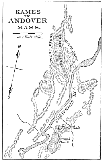
Fig. 30.—Kames in Andover Mass.
In New England attention was first directed to kames in 1842, by President Edward Hitchcock, in a paper before the American Association of Geologists and Naturalists, describing the gravel ridges in Andover, Mass. In the accompanying plate is shown a portion of this kame system, which has a double interest to me from the fact that it was while living upon the banks of the Shawshin River, near where the kames and the river intersect, that I began, in 1874, my special study of glacial deposits. The Andover ridges are composed of imperfectly stratified water-worn material, and are very sharply defined, from the town of Chelsea, back from the coast into New Hampshire, for a distance of twenty-five miles. The base of the ridges does not maintain a uniform level, but the system descends into shallow valleys, and rises over elevations of one hundred to two hundred feet, without interruption. This indifference to slight changes of level is specially noticeable where the system crosses the Merrimac River, just above the city of Lawrence. It is also represented in the accompanying plate, where the base of the ridges in the immediate valley of the Shawshin is fifty feet lower than the base of those a short distance to the north, at the points marked a, b, and c. The ridges here terminate at the surface in a sharp angle, and are above their base forty-one feet at a, forty-nine feet at b, and ninety-one feet at c. Between c and b there is an extensive peat-swamp, filling the depression up to the level of an outlet through which the surplus water has found a passage.
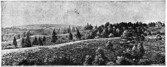
Fig. 31.—Longitudinal kames near Hingham, Massachusetts. The parallel ridges of gravel in the foreground run nearly east and west, and coalesce at each end, near the edges of the picture, to form an elongated kettle-hole. The ridges from fifty to sixty feet in height. The kame-stream was here evidently emptying into the ocean a few miles to the east (Bouvé).
Several systems of kames approximately parallel to this have been traced out in Massachusetts and New Hampshire, while the remnants of a very extensive system are found in the Connecticut Valley above the Massachusetts line. But they abound in greatest profusion in the State of Maine, where Professor George H. Stone has plotted them with much care. The accompanying map gives only an imperfect representation of the ramifying systems which he has traced out, and of the extent to which they are independent of the present river-channels. One of the longest of these extends more than one hundred miles, crossing the Penobscot River nearly opposite Grand Lake, and terminating in an extensive delta of gravel and sand in Cherryfield, nearly north of Mount Desert. This is represented on our map by the shaded portion west of the Machias River. Locally these ridges are variously designated as “horsebacks,” “hogbacks,” or “whalebacks,” but that in Andover, Mass., was for some reason called “Indian Ridge.” Nowhere else in the world are these ridges better developed than in New England, except it be in southern Sweden, where they have long been known and carefully mapped.
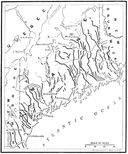
Fig. 32.—The kames of Maine and southeastern New Hampshire. (Stone.)
The investigations of Mr. W. 0. Crosby upon the composition of till in eastern Massachusetts is sufficiently important in its bearings upon the question of glacial erosion to merit notice at this point.[BA] The object of his investigations was to determine how much of the so-called ground moraine, or till, consisted of material disintegrated by mechanical action, and how much by chemical action. The “residuary clay,” which has arisen from chemical decomposition, would properly be attributed to the disintegrating agencies of preglacial times, while the clay, which is strictly mechanical in its origin, remains to represent the true “grist” or “rock flour” of the Glacial period.
The results of Mr. Crosby’s investigations show that “not more than one-third of the detritus composing the till of the Boston Basin was in existence before the Ice age, and that the remaining two-thirds must be attributed to the mechanical action of the ice-sheet and its accompanying torrents of water. In other words, if we assume the average thickness of the drift as thirty feet, the amount of glacial erosion can scarcely fall below twenty feet. After scraping away the residuary clays and half-decomposed material, the ice-sheet has cut more than an equal depth into the solid rocks.”
Mr. Crosby’s investigations also convinced him that the movement of the till, or ground moraine, underneath the ice was not en masse, but that “it must have experienced differential horizontal movements or flowing, in which, normally, every particle or fragment slipped or was squeezed forward with reference to those immediately below it, the velocity diminishing downward through the friction of the underlying ledges.... The glaciation was not limited to masses which were firmly caught between the ice and the solid ledges, and it was in every case essentially a slipping and not a rolling movement.... These differential horizontal movements mean that the till acted as a lubricant for the ice-sheet; and the clayey element, especially, co-operating in many cases with the pent-up subglacial waters, must have greatly facilitated the onward progress of the ice.” He concludes, therefore, that the onward movement of the vast ice-sheet greatly exceeded that of the main part of the ground moraine, the ice-sheet slipping over the till, the whole being in some degree analogous to that of a great land-slip. “In both cases the progress of a somewhat yielding and mobile mass is facilitated by an underlying clayey layer saturated with water.”
New York, New Jersey, and Pennsylvania.
West of New England the glacial phenomena over the northern part of the United States are equally marked all the way to the Missouri River, and the boundary-line of the glaciated region can be traced with little difficulty. It emerges from New York Bay on Staten Island and enters New Jersey at Perth Amboy. A well-formed moraine covers the northern part of Staten Island, and upon the mainland marks the boundary from Perth Amboy, around through Raritan, Plainfield, Chatham, Morris, and Hanover, to Rockaway, and thence in a southwesterly direction to Belvidere, on the Delaware River. That portion of New Jersey lying north of this serpentine line of moraine hills is characterised by the presence of transported boulders, by numerous lakes of evident glacial origin, and by every other sign of glacial action, while south of it all these peculiar characteristics are absent. The observant passenger upon the railroad trains between New York and Philadelphia can easily recognise the moraine as it is passed through on the Pennsylvania Railroad at Metuchen and on the Bound Brook Railroad at Plainfield. Near Drakestown, in Morris County, there is a mass of blue limestone measuring, as exposed, thirty-six by thirty feet, and which was quarried for years before discovering that it was a boulder brought with other drift material from many miles to the northwest and lodged here a thousand feet above the sea.
Across Pennsylvania the glacial boundary passes through Northampton, Monroe, Luzerne, Columbia, Sullivan, Lycoming, Tioga, and Potter Counties, where it enters the State of New York, running still in a northwest direction through Allegany and Cattaraugus Counties to the vicinity of Salamanca. Here it turns to the south nearly at a right angle, running southwestward to Chautauqua County and re-entering Pennsylvania in Warren County, and thence passing onward in the same general direction through Crawford, Venango, Mercer, Butler, and Lawrence Counties to the Ohio line in Columbiana County, about ten miles north of the Ohio River.
The occurrence of a well-defined terminal moraine to mark the glacial boundary eastward from Pennsylvania led Professor Lewis and myself, who made the survey of that State in 1880, to be rather too sanguine in our expectations of finding an equally well-marked moraine everywhere along the southern margin of the glaciated area; still, the results are even more interesting than would have been the exact fulfilment of our expectations, since they more fully revealed to us the great complexity of effect which is capable of being brought about by ice-action. Before proceeding farther with the details, therefore, it will be profitable at this point to pause in the narrative and briefly record a few generalisations that have forced themselves into prominence during the years in which field-work has been in progress.
Previous to our explorations in Pennsylvania it had been thought that the indications of ice-action would extend much farther south in the valleys than on the mountains, and this indeed would have been the case if the glaciers in northern Pennsylvania had been of local origin; but our experience very soon demonstrated that the great gathering-place of the snows which produced the glacial movement in northern Pennsylvania could not have been local, but that over the northern part of that State there was distinct evidence of a continental movement of ice whose centre was far beyond the Alleghanies.
For example, we found that the evidences of direct glacial action extended farther south upon the hills and plateaus than they did in the narrow valleys, while everywhere on the very southern border of glacial indications we found boulders that had been brought from the granitic region of northern New York or central Canada. In eastern Pennsylvania we found indeed a terminal moraine more or less distinctly marking the southern border over the highlands. This was more specially true in Northampton and Monroe Counties.
In Northampton County it was very interesting to see long lines of hills, a hundred or more feet in height and lying several hundred feet above the Delaware River, composed entirely of glacial débris, much of which had been brought bodily over the sharp summit of the Blue Ridge, or Kittatinny Mountain, which rises as a continuous wall to the northwest and is everywhere several hundred feet higher than the moraine in Northampton County. The summit of Blue Ridge, also, as far south as the glacial movement extended, shows evident signs of glacial abrasion, some hundreds of feet evidently having been removed by that means, leaving a well-defined shoulder, marking the limits of its southwestern border. Resting upon the summit of the glaciated portion of the Blue Ridge, there are also numerous boulders of Helderberg limestone, which must have been brought from ledges at least five hundred feet lower than the places upon which they now lie.
In Monroe County the terminal moraine marking there the extreme limit of the ice-movement is upon an extensive plateau of Pocono sandstone, about eighteen hundred feet above sea-level, and five or six hundred feet lower than the crest of the Alleghany Mountains, a short distance to the north. The moraine hills are here well marked by the occurrence of circular lakelets and kettle-holes (such as have been described as characteristic of the shores and islands bordering the south of New England); by the occurrence of granitic boulders, which must have been brought from the Adirondacks or Canada; and by the various other indications referred to on a previous page.
As already intimated, the instructive point in our observations is the fact that, between Kittatinny Mountain, in Northampton County, and Pocono plateau, in Monroe County, there is a longitudinal depression, running northeast by southwest, parallel with the ranges of the mountain system, which is here about a thousand feet below the respective ridges on either side. This, therefore, is one of the places where we should have expected a considerable southern extension of the ice, if it had been largely due to local causes. Now, while there is indeed a gradual southern trend down the flanks of the mountain, yet, upon reaching the axis of the valley, there appears at once a very marked change in the character of the deposit, and the influence of powerful streams of water becomes manifest, and it is evident, upon a slight inspection, that we have come upon a line of drainage which sustained a peculiar relation to the continental ice-sheet.
From Stroudsburg, near the Delaware Water-Gap, to Weissport, on the Lehigh River, a distance of about thirty miles, the valley between the mountains is continuous, and the elevation at each end very nearly the same. But about half-way between the two places, near Saylorsburg, there is a river-parting from which the water now runs on the one hand north to Stroudsburg, and thence to the Delaware River, and on the other hand south, through Big and Aquonchichola Creeks, to the Lehigh River. The river-parting is formed by a great accumulation of gravel, whose summit is about two hundred feet above the level of the valleys into which the creeks empty at either end; and there are numerous kettle-holes and lakelets in the vicinity, such as characterize the glacial region in general.
In short, we are, without doubt, here on a well-marked terminal moraine much modified by strong water-action in a valley of glacial drainage. The gravel and boulders are all well water-worn, and the material is of various kinds, including granite boulders from the far north, such as characterise the terminal moraine on the highlands; but the pebbles are not scratched, and the gravel is more or less stratified. It is evident that we are here where a violent stream of water poured forth from that portion of the ice-front which filled this valley, and which found its only outlet in the direction of the Lehigh River. The gravel can be traced in diminishing quantities to the southward, in accordance with this theory, while to the northward there extends a series of gravel ridges, or kames, such as we have shown naturally to owe their origin to the accumulations taking place in ice-channels formed near the front of a glacier as it slowly melts away.
From similar occurrences of vast gravel accumulations in other valleys stretching southward from the glacial margin, we came to expect that, wherever there was an open, line of drainage from the glaciated region southward, the point of intersection between the glacial margin and the drainage valley would be marked by an excessive accumulation of water-worn gravel, diminishing in coarseness and abundance down the valleys in proportion to the distance from the glacial margin.
For example, the Delaware River emerges from the glaciated region at Belvidere, and there are there vast accumulations of gravel rising a hundred or more feet above the present level of the river, while gravel terraces, diminishing in height, mark the river below to tide-water at Trenton. The Lehigh River leaves the glaciated region at Hickory Run, a few miles above Mauch Chunk, but the gorge is so steep that there was little opportunity either for the accumulation of gravel there or for its preservation. Still, the transported gravel and boulders characteristic of the melting floods pouring forth from a glacier, are found lining the banks of the Lehigh all along the lower portion of its course. In the Susquehanna River we have a better example at Beach Haven, in Luzerne County, where there are very extensive accumulations of gravel resting on the true glacial deposits of the valley, and extending down the river in terraces of regularly diminishing height for many miles, and merging into terraces of moderate elevation which line the Susquehanna Valley throughout the rest of its course. Above Beach Haven the gravel deposits in the trough of the river valley are more irregular, and betray the modifying influence of the slowly decaying masses of ice which belonged to the enveloping continental glacier.
Westward from the north fork of the Susquehanna, similar extensive accumulations of gravel occur at the intersection of Fishing Creek in Columbia County, Muncy, Loyalsock, Lycoming, and Pine Creeks in Lycoming County, all tributary to the Susquehanna River, and all evidently being channels through which the melting floods of the ice-sheet brought vast quantities of gravel down to the main stream. Williamsport, on the West Branch of the Susquehanna, is built upon an extensive terrace containing much granitic material, brought down from the glaciated region by Lycoming Creek, when it was flooded with the waters melted from the continental ice-sheet which had here surmounted the Alleghanies and invaded the valley of the Susquehanna.
Analogous deposits of unusual amounts of gravel, occurring in streams flowing southward from the glaciated region, occur at Great Valley, Little Valley, and Steamburg in Cattaraugus County, New York, and at Russelburg and Garland in Warren County, Pennsylvania, also at Titusville and Franklin in Venango County, and at Wampum in Lawrence County, of the same State.
As a rule, Professor Lewis and myself found it more difficult to determine with accuracy the exact point to which the ice extended in the axis of these south-flowing valleys than we did upon the highlands upon either side; and, in looking for the positive indications of direct ice-action in these lines of drainage, we were almost always led up the valley to a considerable distance inside of the line. This arose from our inexperience in interpreting the phenomena, or rather from our inattention to the well-known determining facts in the problem. On further reflection it readily appeared that this was as it should be. The ice-front, instead of extending farther down in a narrow valley than on the adjoining highlands (where they are of only moderate elevation) ought not to extend so far, for the subglacial streams would not only wear away the ice of themselves, but would admit the air into the tunnels formed by them so as to melt the masses both from below and from above, and thus cause a recession of the front. If we had understood this principle at the beginning of our survey, it would have saved us much perplexity and trouble.
A single further illustration of this point will help to an understanding of many references which will hereafter be made to the water deposits which accumulated in the lines of drainage running southward from the glaciated area. At Warren, Pa., Conewango Creek, which is the outlet from Chautauqua Lake, enters the Alleghany River after flowing for a number of miles in a deep valley with moderate slopes. In ascending the creek from Warren, the gravel terraces, which rise twenty-five or thirty feet above high-water mark, rapidly increase in breadth and height, and the pebbles become more and more coarse. After a certain distance the regular terraces begin to give place to irregular accumulations of gravel in ridges and knobs. In the lower portion of the valley no pebbles could be found which were scratched. Up the valley a few miles pebbles were occasionally discovered which showed some slight indications of having been scratched, but which had been subjected to such an amount of abrasion by water-action as almost to erase the scratches. On reaching Ackley’s Station, the stream is found to be cutting through a regular terminal moraine, extending across the valley and full of clearly marked glaciated stones. Above this terminal moraine the terraces and gravel ridges which had characterised the valley below disappear, giving place to long stretches of level and swampy land, which had been subject to overflow.
Something similar to this so often appears, that there can be no question as to its meaning, which is, that during the farthest extent of the ice the front rested for a considerable period of time along the line marked by the terminal moraine. During this period there occurred both the accumulation of the moraine and of the gravel terraces in the valley below, due to the vast flow of water emerging from the ice-front, especially during the period when it was most rapidly melting away. Upon the retreat of the ice, the moraine constituted a dam which has not yet been wholly worn away. For a while the water was so effectually ponded back by this as to form a lake, which has since become filled up with sediment and accumulations of peat. From this it is evident, also, that when the ice began to retreat, the retreat was so continuous and rapid that no parallel terminal moraines were formed for many miles.
Before leaving this section we will summarise the leading facts concerning the glacial phenomena north of Pennsylvania and New Jersey. From the observations of Professor Smock, it appears that, from the southern margin the ascent to the summit of the ice-sheet was pretty rapid; the depth one mile back from the margin being not much less than a thousand feet. “Northward the angle of the slope diminished, and the glacier surface approximated to a great level plain. The distance between the high southwestern peaks of the Catskills and Pocono Knob in Pennsylvania is sixty miles. The difference in the elevation of the glacier could not have exceeded a thousand feet,” [BB] that is, the slope of the surface was about seventeen feet to the mile.
Professor Dana estimates the thickness of the ice in southern Connecticut to have been between fifteen hundred and two thousand feet. Attempts to calculate the thickness of the ice farther north, except from actual discovery of glacial action on the summits of the mountains, are based upon uncertain data with reference to the slope necessary to secure glacial movement. In the Alps the lowest mean slopes down which glaciers move are about two hundred and fifty feet to a mile; but in Greenland, Jensen found the slope of the Frederickshaab Glacier to be only seventy-five feet to the mile, while Helland found that of the Jakobshavn Glacier to be only forty-five feet.
It is doubtful if even that amount is necessary to secure a continental movement of ice, since, as already remarked, it is unsafe to draw inferences concerning the movements of large masses of ice from those of smaller masses in more constricted areas. We have seen, from the glacial deposits on the top of Mount Washington, that over the northern part of New England the ice was more than a mile in depth. We have no direct evidence of the depth of the stream which surrounded the Adirondack Mountains. Nor, on the other hand, are we certain that the Catskills were not completely enveloped in ice, though most observers, reasoning from negative evidence, have supposed that to be the case. But from the facts stated concerning the boulders along the glacial boundary in Pennsylvania, it is certain that the ice was deep enough to surmount the ridge of the Alleghanies where they are two thousand and more feet in height. At the least calculation the ice must have been five hundred feet thick, in order to secure the movement of which there is evidence across the Appalachian range. Supposing this to be the height of the ice above the sea on the crest of the Alleghanies, and that the slope of the surface of the ice-sheet was as moderate as Professor Smock has estimated it (namely seventeen feet to the mile), the ice would be upwards of six thousand feet in thickness in the latitude of the Adirondacks, which corresponds closely with the positive evidence Ave have from the mountains in New England.
A study of the map of New York will make it easy to understand the distribution of some interesting glacial marks over the State. The distance along the Hudson from the glacial boundary in the vicinity of New York to the valley of the Mohawk is about one hundred and sixty miles. Prom the glacial boundary at Salamanca, N. Y., to the same valley, is not over eighty miles. It is easy to see, therefore, that when, in advancing, the ice moved southward past the Adirondacks, the east end of the valley of the Mohawk was reached and closed by the ice, while at the west end of Lake Ontario the ice-front was still in Canada. Thus the drainage, which naturally followed the course of the St. Lawrence, would first be turned through the Mohawk. Afterwards, when the Mohawk had been closed by ice, the vast amount of ponded water was compelled to seek a temporary outlet over the lower passages leading into the Susquehanna or into the Alleghany.
A number of such passages exist. One can be traced along the line of the old canal from Utica to Binghamton, whose highest level is not far from eleven hundred feet. Another lies in a valley leading south of Cayuga Lake, whose highest point, at Wilseyville, is nine hundred and forty feet above tide. Another leads south to the Chemung River from Seneca Lake, whose highest point, at Horseheads, is less than nine hundred feet above tide. The cols farther west are somewhat more elevated; the one at Portage, leading from the Genesee River into the Canisteo, being upwards of thirteen hundred feet, and that of Dayton, leading from Cattaraugus Creek into the Conewango, being about the same. Of other southern outlets farther west we will speak later on.
Fixing our minds now upon the region under consideration, in the southern part of the State of New York, we can readily see that a glacial lake must have existed in front of the ice while it was advancing, until it had reached the river-partings between the Mohawk and the St. Lawrence Rivers on the north and the Susquehanna and Alleghany Rivers on the south. After the ice had attained its maximum extension, and was in process of retreat, there would be a repetition of the phenomena, only they would occur in the reverse order. The glacial markings which we see are, of course, mainly those produced during the general retreat of the ice.
The Susquehanna River stretching out its arms—the Chenango and Chemung Rivers—to the east and the west, evidently serves as a line of drainage for the vast glacial floods. These floods have left, along their courses, extensive elevated gravel terraces, with much material in them which is not local, but which has been washed out of the direct glacial deposits from the far north. The east-and-west line of the water-parting throughout the State is characterised by excessive accumulations of glaciated material, forming something like a terminal moraine, and is designated by President Chamberlin as “the terminal moraine of the second Glacial epoch,” corresponding, as he thinks, to the interior line already described as characterising the south shore of New England.
In the central part of New York the remarkable series of “Finger Lakes,” tributary to Lake Ontario and emptying into it through the Oswego and Genesee Rivers, all have a glacial origin. Probably, however, they are not due in any great degree to glacial erosion, but they seem to occupy north-and-south valleys which had been largely formed by streams running towards the St. Lawrence when there was, by some means (probably through the Mohawk River), a much deeper outlet than now exists, but which has been filled up and obliterated by glacial débris. The ice-movement naturally centred itself more or less in these north-and-south valleys, and hence somewhat enlarged them, but probably did not deepen them. The ice, however, did prevent them from becoming filled with sediment, and on its final retreat gave place to water.
Between these lakes and Lake Ontario, also, and extending east and west nearly all the way from Syracuse to Rochester, there is a remarkable series of hills, from one hundred to two or three hundred feet in height, composed of glacial débris. But while the range extends east and west, the axis of the individual hills lies nearly north and south. These are probably remnants of a morainic accumulation which were made during a pause in the first advance of the ice, and were finally sculptured into their present shape by the onward movement of the ice. These are really “drumlins,” similar to those already described in northeastern Massachusetts and southeastern New Hampshire. In the valley of central New York these have determined the lines of drainage of the “Finger Lakes,” and formed dams across the natural outlets of nearly all of them.
North of the State of New York the innumerable lakes in Canada are all of glacial origin, being mostly due to depressions of the nature of kettle-holes, or to the damming up of old outlets by glacial deposits. A pretty well-marked line of moraine hills, formed probably as terminal deposits in the later stages of the Ice age, runs from near the eastern end of Lake Ontario to the Georgian Bay, passing south of Lake Simcoe.
The Mississippi Basin.
The physical geography of the glaciated region north of the Ohio River is so much simpler than that of New England and the Middle States, that its characteristics can be briefly stated. Ohio, Indiana, and Illinois are covered with nearly parallel strata of rock mostly of the Carboniferous age. In general, the surface slopes gently to the west; the average elevation of Ohio being about a thousand feet above tide, while that of the Great Lakes to the north and of the middle portion of the Mississippi Valley is less than six hundred feet. The glacial deposits are spread in a pretty even sheet over the area which was reached by the ice in these States, and the lines of moraine, of which a dozen or more have been partially traced in receding order, are much less clearly marked than they are in New England, or in Michigan, and the States farther to the northwest.
The line marking the southern limit attained by the ice of the Glacial period in these three States is as follows: Entering Ohio in Columbiana County, about ten miles north of the Ohio River, the glacial boundary runs westward through New Lisbon to Canton in Stark County, and thence to Millersburg in Holmes County. A few miles west of this place it turns abruptly south, passing through Danville in Knox County, Newark in Licking County, Lancaster in Fairfield County, to Adelphi in Ross County. Thence bearing more westward it passes through Chillicothe to southeastern Highland County and northwestern Adams, reaching the Ohio River near Ripley, in Clermont County. Thence, following the north bank of the Ohio River to Cincinnati, it crosses the river, and after extending through the northern part of Boone County, Kentucky, and recrossing the river to Indiana, not far from Rising Sun, it again follows approximately the north bank of the river to within about ten miles of Louisville, Ky., where it bends northward running through Clarke, Scott, Jackson, Bartholomew, and Brown Counties to Martinsville, in Morgan County, where it turns again west and south and follows approximately the West Branch of the White River through Owen, Greene, and Knox Counties, where it crosses the main stream of White River, and, continuing through Gibson and Posey Counties, crosses the Wabash River near New Harmony.
In Illinois the line still continues southwesterly through White, Gallatin, Saline, and Williamson Counties, where it reaches its southern limit near Carbondale, in latitude 37° 40’, and from this point trends northwestward, approximately following the northeastern bluff of the Mississippi River, to the vicinity of Carondelet, Mo., a short distance south of St. Louis.
Beyond the Mississippi the line follows approximately the course of the Missouri River across Missouri, and continues westward to the vicinity of Manhattan, in Kansas, where it turns northward, keeping about a hundred miles west of the Missouri River, through eastern Kansas and Nebraska, and striking the river near the mouth of the Niobrara, in South Dakota. From there the line follows approximately the course of the Missouri River to the vicinity of Fort Benton, in northwestern Montana, where the line again bears more northward, running into British America.
It is still in dispute whether the ice extended from the eastern centre far enough west to join the ice-movement from the Rocky Mountain plateau. Dr. George M. Dawson[BC] is of the opinion that it did not, but that there was a belt of a hundred miles or more, east of the Rocky Mountains, which was never covered by true glacial ice. Mr. Upham[BD] is equally confident that the two ice-movements became confluent, and united upon the western plateau of Manitoba. The opportunity for such a difference of opinion arises in the difficulty sometimes encountered of distinguishing between a direct glacial deposit and a deposit taking place in water containing boulder-laden icebergs. Where Mr. Upham supposes the ice-fields of the east and of the west to have been confluent in western Manitoba, Dr. Dawson supposes there was an extensive subsidence of the land sufficient to admit the waters of the ocean. Leaving this question for the present undetermined, we will now rapidly summarise the glacial phenomena west of the third meridian from Washington (which corresponds nearly with the western boundary of Pennsylvania), and east of the Rocky Mountains.