Front matter (continued 5)
Reading edition
In Greenland such temporary obstructions are frequent, forming lakes of considerable size. Instances occur, in connection with the Jakobshavn and the Frederickshaab Glaciers, and in the North Isortok and Alangordlia Fiords.
Frequently, also, bodies of water of considerable size are found in depressions of the ice itself, even at high levels. I have myself seen them covering more than an acre, and as much as a thousand feet above the sea-level, upon the surface of the Muir Glacier, Alaska. They are reported by Mr. I. C. Russell[CG] of larger size and at still higher elevations upon the glaciers radiating from Mount St. Elias; while the explorers of Greenland mention them of impressive size upon the surface of its continental ice-sheet.
With these facts in mind we can the more readily enter into the description which will now be given of some temporary lakes of vast size which were formed by direct ice-obstructions during portions of the period.
One of the most interesting of these is illustrated upon the accompanying map, which will need little description.
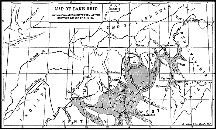
Fig. 54.—Map showing the effect of the glacial dam at Cincinnati (Claypole). (From Transactions of the Edinburgh Geological Society.)
While tracing the boundary-line of the glaciated area in the Mississippi Valley during the summer of 1882, I discovered the existence of unmistakable glacial deposits in Boone County, Kentucky, across the Ohio River, from Cincinnati.[CH]; These deposits were upon the height of land 550 feet above the Ohio River, or nearly 1,000 feet above the sea, which is about the height of the water-shed between the Licking and Kentucky Rivers. As the Ohio River occupies a trough of erosion some hundreds of feet in depth, and extending all the way from this point to the mountains of western Pennsylvania, it would follow that the ice which conveyed boulders across the Ohio River at Cincinnati, and deposited them upon the highlands between the Licking and Kentucky Rivers, would so obstruct the channel of the Ohio as to pond the water back, and hold it up to the level of the lowest pass into the Ohio River farther down. Direct evidences of obstruction by glacial ice appear also for a distance of fifty or sixty miles, extending both ways, from Cincinnati.
The consequences connected with this state of things are of the most interesting character.
The bottom of the Ohio River at Cincinnati is 432 feet above the sea-level. A dam of 550 feet would raise the water in its rear to a height of 982 feet above tide. This would produce a long, narrow lake, of the width of the eroded trough of the Ohio, submerging the site of Pittsburg to a depth of 281 feet, and creating slack water up the Monongahela nearly to Grafton, West Virginia, and up the Alleghany as far as Oil City. All the tributaries of the Ohio would likewise be filled to this level. The length of this slack-water lake in the main valley, to its termination up either the Alleghany or the Monongahela, was not far from one thousand miles. The conditions were also peculiar in this, that all the northern tributaries rose within the southern margin of the ice-front, which lay at varying distances to the north. Down these there must have poured during the summer months immense torrents of water to strand boulder-laden icebergs on the summits of such high hills as were lower than the level of the dam.
Naturally enough, this hypothesis of a glacial dam at Cincinnati aroused considerable discussion, and led to some differences of opinion. Professors I. C. White and J. P. Lesley, whose field work has made them perfectly familiar with the upper Ohio and its tributaries, at once supported the theory, with a great number of facts concerning certain high-level terraces along the Alleghany and Monongahela Rivers; while additional facts of the same character have been brought to light by myself and others. In general, it may be said that in numerous places terraces occur at a height so closely corresponding to that of the supposed dam at Cincinnati, that they certainly strongly suggest direct dependence upon it. The upward limit of these terraces in the Monongahela River is 1,065 feet, and they are found in various places in situations which indicate that they were formed in still water of such long standing as would require an obstruction below of considerable permanence.
One of the most decisive cases adduced by Professor White occurs near Morgantown, in West Virginia, of which he gives the following description:
“Owing to the considerable elevation—275 feet—of the fifth terrace above the present river-bed in the vicinity of Morgantown, its deposits are frequently found far inland from the Monongahela, on tributary streams. A very extensive deposit of this kind occurs on a tributary one mile and a half northeast of Morgantown; and the region, which includes three or four square miles, is significantly known as the ‘Flats.’ The elevation of the ‘Flats’ is 275 feet above the river, or 1,065 feet above tide. The deposits on this area consist almost entirely of clays and fine, sandy material, there being very few boulders intermingled. The depth of the deposit is unknown, since a well sunk on the land of Mr. Baker passed through alternate beds of clay, fine sand, and muddy trash, to a depth of sixty-five feet without reaching bed-rock. In some portions of the clays which make up this deposit, the leaves of our common forest-trees are found most beautifully preserved.
“At Clarksburg, where the river unites with Elk Creek, there is a wide stretch of terrace deposits, and the upper limit is there about 1,050 feet above tide, or only 130 feet above low-water (920 feet); while at Weston, forty miles above (by the river), these deposits cease at seventy feet above low water, which is there 985 feet above tide. It will thus be observed that the upper limit of the deposits retains a practical horizontality from Morgantown to Weston, a distance of one hundred miles, since the upper limit has the same elevation above tide (1,045 to 1,065 feet) at every locality.
“These deposits consist of rounded boulders of sandstone, with a large amount of clay, quicksand, and other detrital matter. The country rock in this region consists of the soft shales and limestones of the upper coal-measures, and hence there are many ‘low gaps’ from the head of one little stream to that of another, especially along the immediate region of the river; and in every case the summits of these divides, where they do not exceed an elevation of 1,050 feet above tide, are covered with transported or terrace material; but where the summits go more than a few feet above that level we find no transported material upon them, but simply the decomposed country rock.”
Other noteworthy terraces naturally attributable to the Cincinnati ice-dam are to be found in the valley of the Kanawha, in West Virginia, and one of special significance on the pass between the valleys of the Ohio and Monongahela, west of Clarksburg, West Virginia. According to Professor White, there is at this latter place “a broad, level summit, having an elevation of 1,100 feet, in a gap about 300 feet below the enclosing hills. This gap, or valley, is covered by a deposit of fine clay. The cut through it is about thirty feet, and one can observe the succession of clays of all kinds and of different colours, from yellow on the surface down to the finest white potter’s clay at the level of the railway, where the cut reaches bed-rock, thus proving that the region has been submerged.”[CI]
Another crucial case I have myself described at Bellevue, in the angle of the Ohio and Alleghany Rivers, about five miles below Pittsburg, where the gravel terrace is nearly 300 feet above the river, making it about 1,000 feet above the sea. A significant circumstance connected with this terrace is that not only does its height correspond with that of the supposed obstruction at Cincinnati, but it contains many pebbles of Canadian origin, which could not have got into the valley of the Alleghany before the Glacial period, and could only have reached their present position by being brought down the Alleghany River upon floating ice, or by the ordinary movement of gravel along the margin of a river. Thus this terrace, while corresponding closely with the elevation of those on the Monongahela River, is directly connected with the Glacial period, and furnishes a twofold argument for our theory.
A still stronger case occurs at Beech Flats, at the head of Ohio Brush Creek, in the northwest corner of Pike County, Ohio, where, at an elevation of about 950 feet above the sea, there is an extensive flat-topped terrace just in front of the terminal moraine. This terrace consists of fine loam, such as is derived from the glacial streams, but which must have been deposited in still water. The occurrence of still water at that elevation just in front of the continental ice-sheet is best accounted for by the supposed dam at Cincinnati. Indeed, it is extremely difficult to account for it in any other way.
There are, however, two other methods of attempting to account for the class of facts above cited in support of the ice-dam theory, of which the most plausible is, that in connection with the Glacial period there was a subsidence of the whole region to an extent of 1,100 feet.
The principal objection heretofore alleged against this supposition is that there are not corresponding signs of still-water action at the same level on the other side of the Alleghany Mountains. This will certainly be fatal to the subsidence theory, if it proves true. But it is possible that sufficient search for such marks has not yet been made on the eastern side of the mountains.
The other theory to account for the facts is, that the terraces adduced in proof of the Cincinnati ice-dam were left by the streams in the slow process of lowering their beds from their former high levels. This is the view advocated by President T. C. Chamberlin. But the freshness of the leaves and fragments of wood, such as were noted by Professor White at Morgantown, and the great extent of fine silt occasionally resting upon the summits of the water-sheds, as described above, near Clarksburg, bear strongly against it. Furthermore, to account for the terrace described at Bellevue, which contains Canadian pebbles, President Chamberlin is compelled to connect the deposit with his hypothetical first Glacial epoch, and to assume that all the erosion of the Alleghany and Monongahela Rivers, and indeed of the whole trough of the Ohio River, took place in the interval between the “first” and the “second” Glacial periods (for he would connect the glacial deposits upon the south side of the river at Cincinnati with the first Glacial epoch)—all of which, it would seem, is an unnecessary demand upon the forces of Nature, when the facts are so easily accounted for by the simple supposition of the dam at Cincinnati.[CJ]
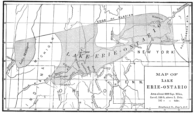
Fig. 55.—Map showing the condition of things when the ice-front had withdrawn about on hundred and twenty miles, and while it still filled the valley of the Mohawk. The outlet was then through the Wabash. Niagara was not yet born (Claypole). (Transactions of the Edinburgh Geological Society.)
We have already described[CK] the various temporary lakes and lines of drainage caused by the direct obstruction of the northward outlets to the basin of the Great Lakes. In connection with the map, it will be unnecessary to do anything more here than add a list of such temporary southern outlets from the Erie-Ontario basin.[CL] The first is at Fort Wayne, Indiana, through a valley connecting the Maumee River basin with that of the Wabash. The channel here is well defined, and the high-level gravel terraces down the Wabash River are a marked characteristic of the valley. The elevation of this col above the sea is 740 feet. Similar temporary lines of drainage existed from the St. Mary’s River to the Great Miami, at an elevation of 942 feet; from the Sandusky River to the Scioto, through the Tymochtee Gap, at an elevation of 912 feet; from Black River to the Killbuck (a tributary of the Muskingum) through the Harrisville Gap, at 911 feet; from the Cuyahoga into the Tuscarawas Valley, through the Akron Gap, at 971 feet; from Grand River into the Mahoning, through the Orwell Gap, 938 feet; from Cattaraugus Creek, N. Y., into the Alleghany Valley through the Dayton Gap, about 1,300 feet; between Conneaut Creek and Shenango River, at Summit Station, 1,141 feet; from the Genesee River, N. Y., into the head-waters of the Canisteo, a branch of the Susquehanna, at Portageville, 1,314 feet; from Seneca Lake to Chemung River, at Horseheads, 879 feet; from Cayuga Lake to the valley of Cayuga Creek, at Spencer, N. Y., 1,000 feet; from Utica, N. Y., into the Chenango Valley at Hamilton, about 900 feet.
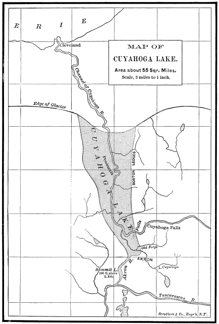
Fig. 56.—Map illustrating a stage in the recession of the ice in Ohio. For a section of the deposit in the bed of this lakelet, see page 200. The gravel deposits formed at this stage along the outlet into the Tuscarawas River are very clearly marked (Claypole). (Transactions of the Edinburgh Geological Society.)
Perhaps it would have been best to give this list in the reverse order, which would be more nearly chronological, since it is clear that the highest outlets are the oldest. We should then have to mention, after the Fort Wayne outlet, two others at lower levels which are pretty certainly marked by distinct beach ridges upon the south side of Lake Erie. The first was opened when the ice had melted back from the south peninsula of Michigan to the water-shed across from the Shiawassee and Grand Rivers, uncovering a pass which is now 729 feet above the sea. This continued to be the outlet of Lake Erie-Ontario until the ice had further retreated beyond the Strait of Mackinac, when the water would fall to the level of the old outlet from Lake Michigan into the Illinois River, which is a little less than 600 feet, where it would remain until the final opening of the Mohawk River in New York attracted the water in that direction, and lowered the level to that of the pass from Lake Ontario to the Mohawk at Rome.[CM]
A study of these lines of temporary drainage during the Glacial period sheds much light upon the long lines of gravel ridges running parallel with the shores of Lake Erie and Lake Ontario. South of Lake Erie a series of four ridges of different elevations can be traced. In Lorain County, Ohio, the highest of these is 220 feet above the lake; the next 160 feet; the next 118 feet; and the lower one 100 feet, which would make them respectively 795, 755, 715, and 700 feet above tide.
These gravel ridges are evidently old beach lines, and indicate the different levels up to which the water was held by ice-obstructions across the various outlets of the drainage valley. The material in the ridges is water-worn and well assorted, and in coarseness ranges from fine sand up to pebbles several inches in diameter. The predominant material in them is of local origin. Where the rocks over which they run are sandstone, the material is chiefly sand, and where the outcropping rock is shale, the ridges consist chiefly of the harder nodules of that formation which have successfully resisted the attrition of the waves. Ordinarily these ridges are steepest upon the side facing the lake. According to Mr. Upham, who has driven over them with me, the Lake Erie ridges correspond, both in general appearance and in all other important respects, to those which he has so carefully surveyed around the shores of the ancient Lake Agassiz in Minnesota and Manitoba, an account of which will be given a little farther on in this chapter.
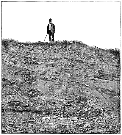
Fig. 57.—Section of the lake ridges near Sandusky, Ohio.
We are not permitted, however, to assume that there have been no changes of level since the deposition of these beaches surrounding the ancient glacial Lake Erie-Ontario. On the contrary, there appears to have been a considerable elevation towards the east and northeast in post-glacial times. The highest ridge south of Lake Erie, which at Fort Wayne is about 780 feet high, is now about 795 feet in Lorain County. The second of the ridges above-mentioned, which is about 740 feet above tide at Cleveland, Ohio, rises to 870 feet where the last traces of it have been discovered at Hamburg, N. Y. The third ridge, which is 673 feet at Cleveland, has risen to the height of 860 feet at Crittenden, about one hundred miles to the east of Buffalo, N. Y.
A similar eastern increase of elevation is discoverable in the main ridge surrounding Lake Ontario. What Professor Spencer calls the Iroquois beach, which is 363 feet above tide at Hamilton, Ontario, has risen to a height of 484 feet near Syracuse, N. Y.; while farther to the northeast, in the vicinity of Watertown, it is upwards of 800 feet above tide.
There is also a similar northward increase of elevation in the beaches surrounding the higher lands of Ontario eastward of Lake Huron and Georgian Bay.
All this indicates that at the close of the Glacial period there was a subsidence of several hundred feet in the area of greatest ice-accumulation lying to the east and north of the Great Lake region. The formation of these ridges occurred during that period of subsidence. The re-elevation which followed the disappearance of the ice of course carried with it these ridges, and brought them to their present position.[CN]
In returning to consider more particularly the remarkable gorge joining the Minnesota with the Red River of the North, we are brought to the largest of the glacial lakes of this class, and to the typical place in America in which to study the temporary changes of drainage produced by the ice itself daring the periods both of its advance and of its retreat.
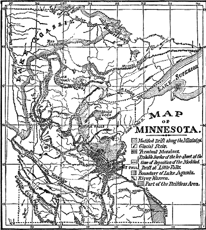
Fig. 58.—Map showing the stages of recession of the ice in Minnesota as described in the text (Upham). Click on image to view larger sized.
By turning to our general map of the glaciated region of the United States,[CO] one can readily see the relation of the valley between Lake Traverse and Big Stone Lake to an area marked as the bed of what is called Lake Agassiz. During the Glacial period Brown’s Valley, the depression joining these two lakes, was the outlet of an immense body of water to the north, whose natural drainage was towards Hudson Bay or the Arctic Ocean, but which was cut off, by the advancing ice, from access to the ocean-level in that direction, and was compelled to seek an exit to the south.
Thus for a long period the present Minnesota River Valley was occupied by a stream of enormous dimensions, and this accounts for the great size of the trough—the present Minnesota being but an insignificant stream winding about in this deserted channel of the old “Father of Waters,” and having as much room as a child of tender age would have in his parent’s cast-off garments. This glacial stream has been fittingly named River Warren, after General Warren, who first suggested and proved its existence, and so we have designated it on the accompanying map of Minnesota.
Lake Traverse is fifteen miles long, and the water is nowhere more than twenty feet deep. Big Stone Lake is twenty-six miles long, and of about the same depth. Brown’s Valley, which connects the two, is five miles long, and the lakes are so nearly on a level that during floods the water from Lake Traverse sometimes overflows and runs to the south as well as to the north.
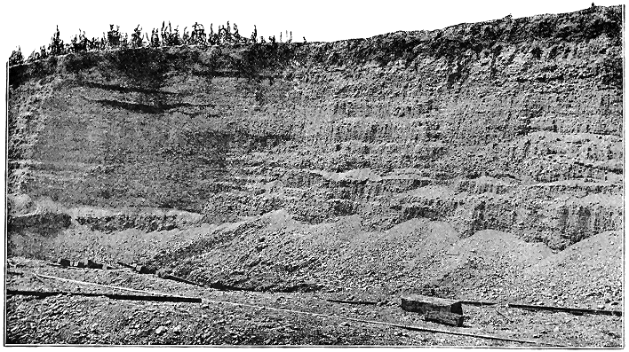
Fig. 59.—Glacial terrace near the boundary of the glaciated area, on Raccoon Creek, a tributary of the Licking River, in Granville, Licking County, Ohio. Height about fifty feet.
The trough occupied by these lakes and valley is from one mile to one mile and a half in width and about 120 feet in depth. If we had been permitted to stand upon the bluffs overlooking it during the latter part of the Glacial period, we should have seen the whole drainage of the north passing by our feet on its way to the Gulf of Mexico. As lie follows down the valley of the Minnesota River, the observant traveller, even now, cannot fail to see in the numerous well-preserved gravel terraces the high-water marks of that stream when flooded with the joint product of the annual precipitation over the vast area to the north, and of the still more enormous quantities set free by the melting of the western part of the great Laurentide Glacier.
Numerous other deserted water-ways in the northwestern part of the valley of the Mississippi have been brought to light in the more recent geological surveys, both in the United States and in Canada. During a considerable portion of the Glacial period the Saskatchewan, the Assiniboine, the Pembina, and the Cheyenne Rivers, whose present drainage is into the Red River of the North, were all turned to the south, and their temporary channels can be distinctly traced by deserted water-courses marked by lines of gravel deposits.[CP]
In Dakota, Professor J. E. Todd has discovered large deserted channels on the southwestern border of the glaciated region near the Missouri River, where evidently streams must have flowed for a long distance in ice-channels when the ice still continued to occupy the valley of the James River. From these channels of ice in which the water was held up to the level of the Missouri Coteau the water debouched directly into channels with sides and bottom of earthy material, which still show every mark of their former occupation by great streams.[CQ]
In Minnesota, also, there is abundant evidence that while the northeastern part of the valley from Mankato to St. Paul was occupied by ice, the drainage was temporarily turned directly southward across the country through Union Slough and Blue Earth River into the head-waters of the Des Moines River in Iowa.
Ancient River Terraces.
The interest of the whole inquiry respecting the relation of man to the Glacial period in America concentrates upon these temporary lines of southern drainage. Wherever they existed, the swollen floods of the Glacial period have left their permanent marks in the deposition of extensive gravel terraces. The material thus distributed is derived largely from the glacial deposits through which they run and out of which they emerge. While the height of the terraces depended upon various conditions which must be studied in detail, in general it may be said that it corresponds pretty closely with the extent of the area whose drainage was turned through the channel during the prevalence of the ice. The height of the terraces and the coarseness of the material seem also to have been somewhat dependent upon the proximity of their valleys to the areas of most vigorous ice-action, and this, in turn, seems to lie in the rear of the moraines which President Chamberlin has attributed to the second Glacial epoch. Southward from this belt of moraines the terraces uniformly and gradually diminish both in height and in the coarseness of their gravel, until they finally disappear in the present flood-plain of the Mississippi River.
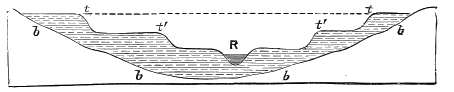
Fig. 60.—Ideal section across a river-bed in drift region: b b b, old river-bed; R, the present river; t t, upper or older terraces; t′ t′, lower terraces.
An interesting illustration of this principle is to be observed in the continuous valley of the Alleghany and Ohio Rivers. The trough of this valley was reached by the continental glacier at only a few points, the ice barely touching it at Salamanca, N. Y., Franklin, Pa., and Cincinnati, Ohio. But throughout its whole length the ice-front was approximately parallel to the valley, and occupied the head-waters of nearly all its tributaries. Now, wherever tributaries which could be fed by glacial floods, enter the trough of the main stream, they brought down an excessive amount of gravel, and greatly increased the size of the terrace in the trough itself, and from the mouth of each such tributary to that of the next one below there is a gradual decrease in the height of the terrace and in the coarseness of the material.
This law is illustrated with special clearness in Pennsylvania between Franklin and Beaver. Franklin is upon the Alleghany River, at the last point where it was reached directly by the ice. Below this point no tributary reaches it from the glaciated region, and none such reaches the Ohio after its junction with the Alleghany until we come to the mouth of Beaver Creek, about twenty-five miles below Pittsburg.
But at this point the Ohio is joined by a line of drainage which emerges from the glaciated area only ten or twelve miles to the north, and whose branches occupy an exceptionally large glaciated area. Accordingly, there is at Beaver a remarkable increase in the size of the glacial terrace on the Ohio. In the angle down-stream between the Beaver and the Ohio there is an enormous accumulation of granitic pebbles, many of them almost large enough to be called boulders, forming the delta terrace, upon which the city is built and rising to a height of 135 feet above the low-water mark in the Ohio. In striking confirmation of our theory, also, the terrace in the Ohio Valley upon the upper side of Beaver Creek is composed of fine material, largely derived from local rocks and containing but few granitic pebbles.
From the mouth of Beaver Creek, down the Ohio, the terrace is constant (sometimes upon one side of the river and sometimes upon the other), but, according to rule, the material of which it is composed gradually grows finer, and the elevation of the terrace decreases. According to rule, also, there is a notable increase in the height of the terrace below each affluent which enters the river from the glaciated region. This is specially noticeable below Marietta, at the mouth of the Muskingum, whose head-waters drain an extensive portion of the glaciated area. From the mouth of the Little Beaver to this point the tributaries of the Ohio are all small, and none of them rise within the glacial limit. Hence they could contribute nothing of the granitic material which enters so largely into the formation of the river terrace; but below the mouth of the Muskingum the terrace suddenly ascends to a height of nearly one hundred feet above low-water mark.
Again, at the mouth of the Scioto at Portsmouth, there is a marked increase in the size of the terrace, which is readily accounted for by the floods which came down the Scioto Valley from the glaciated region. The next marked increase is at Cincinnati, just below the mouth of the Little Miami, whose whole course lay in the glaciated region, and whose margin is lined by very pronounced terraces. At Cincinnati the upper terrace upon which the city is built is 120 feet above the flood-plain.
Twenty-five miles farther down the river, near Lawrenceburg, these glacial terraces are even more extensive, the valley being there between three and four miles wide, and being nearly filled with gravel deposits to a height of 112 feet above the flood-plain. Below this point the terraces gradually diminish in height, and the material becomes finer and more water-worn, until it merges at last in the flood-plain of the Mississippi. The course of the Wabash River is too long to permit it to add materially to the size of the terraces which characterise the broader valley of the Ohio below the Illinois line.
It is in terraces such as these just described that we find the imbedded relics of man which definitely connect him with the great Ice age. These have now been found in the glacial terraces of the Delaware River at Trenton, N. J.; in similar terraces in the valley of the Tuscarawas River at New Comerstown, and in the valley of the Little Miami at Loveland and Madisonville, in Ohio; on the East Fork of White River, at Medora, Ind.; and still, again, at Little Falls, in the trough of the Mississippi, some distance above Minneapolis, Minn.
I append a list of the points at which various streams from the Atlantic Ocean to the Mississippi River emerge from the glacial boundary, and below which the terraces are specially prominent. Of course, with the retreat of the ice, the formation of the terraces continued northward in the glaciated area to a greater or less distance, according to the extent of the valley or to the length of time during which the drainage was temporarily turned into it. These points of emergence are: In the Delaware Valley, at Belvidere, N. J.; in the Susquehanna, at Beach Haven, Pa.; in the Conewango, at Ackley, Warren County; in Oil Creek, above Titusville: in French Creek, a little above Franklin; in Beaver Creek, at Chewtown, Lawrence County; on the Middle Fork of Little Beaver, near New Lisbon, Ohio; on the east branch of Sandy Creek, at East Rochester, Columbiana County; on the Nimishillin, at Canton, Stark County; on the Tuscarawas, at Bolivar; on Sugar Creek, at Beech City; on the Killbuck, at Millersburg, Holmes County; on the Mohican, near the northeast corner of Knox County; on the Licking River, at Newark; on Jonathan Creek, Perry County; on the Hocking, at Lancaster; on the Scioto, at Hopetown, just above Chillicothe; on Paint Creek, and its various tributaries, between Chillicothe and Bainbridge; and on the Wabash, above New Harmony, Ind.; to which may be added the Ohio River itself, at its junction with the Miami, near Lawrenceburg.
Another class of terraces having most interesting connection with the Glacial period is found in the arid basins west of the Rocky Mountains. Over wide areas in Utah and Nevada the evaporation now just balances the precipitation, and all the streams disappear in shallow bodies of salt water of moderate dimensions, of which Great Salt Lake in Utah, and Mono, Pyramid, and North Carson Lakes in Nevada, are the most familiar examples. These occupy the lowest sinks of enclosed basins of great depth.
But there is abundant evidence that in consequence of the increased precipitation and diminished evaporation of the Glacial period one of these basins was filled to the brim and the other to a depth of several hundred feet. These former enlargements have been named after the first explorers of the region, Captains Lahontan and Bonneville, and are shown on the accompanying sketch map by the shading surrounding the existing lakes.
Lake Lahontan has been carefully studied by Mr. I. C. Russell, and has been found to extend from the boundary of Oregon to latitude 38° 30’ south, a distance of two hundred and sixty miles. The Central Pacific Railroad runs through its dried-up bed from Golconda to Wadsworth, a distance of one hundred and sixty-five miles. The terraces of the former lake are distinctly traceable at a height of 700 feet above the present level of Lake Mono.
Lake Bonneville, whose present representative is Great Salt Lake, is the subject of a recent monograph by Mr. G. K. Gilbert, from which it appears that this ancient body of water occupied 19,750 square miles—an area about ten times that of the present lake. At the time of its maximum extension its depth was 1,000 feet, while Great Salt Lake ranges only from fifteen to fifty feet in depth.
The pass through which the discharge finally took place is at Red Rock, on the Utah and Northern Railroad, at the head of Cache Valley on the south and the lower part of Marsh Creek Valley on the north. During the long period preceding and accompanying the gradual rise of water in the Utah basin to the level of the highest terrace, Marsh Creek (the upper portion of which comes from the mountains on the east and turns at right angles) had been at work depositing a delta of loose material in the col which separates the two valleys. This deposit rested upon a stratum of limestone at the bottom of the pass, and covered it with sand, clay, and gravel to a depth of 375 feet. Thus, when the water was approaching its upper level, the only barrier to prevent its escape was this unstable accumulation of loose material upon top of the rock. It would have required, therefore, no prophet’s eye to predict that the way was preparing for a tremendous débâcle.
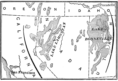
Fig. 61.—Map of the Quaternary Lakes. Bonneville and Lahontan (after Gilbert and Russell).
The critical point at length was reached. After remaining nearly at the elevation of the pass for a considerable period, during which the 1,000-foot shore-line was formed, the crisis came when the water began to flow northward towards Snake River. Once begun in such loose material, the channel rapidly enlarged until soon a stream equal to Niagara, and at times probably much larger, was pouring northward through the valley heretofore occupied by the insignificant rivulets of Marsh Creek and the Port Neuf. It is impossible to tell how rapidly the loose barrier wore away, but there is abundant evidence in the valley below that not only the present channel of the lower part of Marsh Creek, but the whole bottom of the valley for a mile or more in width, was for a considerable time covered by a rapid stream from ten to twenty feet in depth, and descending at the rate of thirteen feet to the mile.
The continuance of this flood was dependent upon the amount of water to be discharged, which, as we have seen, was that contained in an area of 20,000 square miles, with a depth of 375 feet. A stream of the size of Niagara would occupy about twenty-five years in the discharge of such a mass, and this may fairly be taken as a measure of the time through which it lasted. When the loose material lying above the strata of limestone in Red Rock Pass had been washed away, the lake then continued at that level for an indefinite period, with an overflow regulated by the annual precipitation of the drainage basin. This stage of the lake, during which it occupied 13,000 square miles and was 625 feet above its present level, is also marked by an extensive and persistent shore-line all around the basin. But, finally, the balance again turned when the evaporation exceeded the precipitation, and the vast body of water has since dwindled to its present insignificant dimensions.
My own interest in this discovery of Mr. Gilbert is enhanced by the explanation it gives of a phenomenon in the Snake River Valley which I was unable to solve when on the ground in 1890. The present railroad town of Pocatello is situated just where this flood emerged from the narrower valley of Marsh Creek and the Port Neuf, and spread itself out upon the broad plain of the Snake River basin. The southern edge of the plain upon which the city is built is a vast boulder-bed covered with a thin stratum of sand and gravel. Everywhere, in sinking wells and digging ditches on the vacant lots and in the streets of the city, water-worn boulders of a great variety of material and sometimes three or four feet in diameter are encountered. I was debarred from regarding this as a terminal moraine, both by the water-worn character of the boulders and by the absence of any sign of ice-action in the surrounding mountains, and I was equally debarred from attributing it to any ordinary stream of water, both by the size of the boulders and the fact that for a mile or more up the Port Neuf Valley there is an intervale, forty or fifty feet below the surface at Pocatello, and occupying the whole width of the valley, in which there is only gravel and fine sand, through which the present Port Neuf pursues a meandering course. The upper end of this short intervale is bounded by the terminus of a basaltic stream which had flowed down the valley and filled it to a considerable depth, but had subsequently been much eroded by violent water-action.
In the light of Mr. Gilbert’s discoveries, however, everything is clear. The tremendous débâcle which he has brought within the range of scientific vision would naturally produce just the condition of things which is so puzzling at Pocatello. Coming down through the restricted channel with sufficient force to roll along boulders of great size and to clear them all out from the upper portion of the valley, the torrent would naturally deposit them where the current was first checked, a mile below the lava cliffs. The plunge of the water over these cliffs would keep a short space below clear from boulders, and the more moderate stream of subsequent times would fill in the depression with the sand and gravel now occupying it.
What other effects of this remarkable outburst may be traced farther down in the Snake River Valley I cannot say, but it will be surprising if they do not come to light and help to solve some of the many geological problems yet awaiting us in this interesting region.
It should have been said that during the formation of the 625-foot, or so-called Provo shore-line, glaciers descended from the cañons on the west flank of the Wahsatch Mountains, and left terminal moraines to mark the coincidence of the Glacial period with that stage of the enlargement of the lake. Evidences of a similar coincidence are to be found on the high-level terraces surrounding Lake Mono, to which glaciers formerly descended from the western flanks of the Sierra Nevada.
The ancient shore-lines surrounding Lakes Bonneville and Lahontan bear evidence also of various other episodes in the Glacial period. Evidently there were two periods of marked increase in the size of the lakes, with an arid period intervening. During the first rise the level of Bonneville attained to within ninety feet of the second, and numerous beaches were formed, and a large amount of yellow clay deposited. Then it seems to have been wholly evaporated, while its soluble mineral matter was precipitated, and so mingled with silt that it did not readily redissolve during the second great rise of water. Partly on this account, and partly through the influence of the outlet into the Snake River, the lake was nearly fresh during its second enlargement.
European Facts.
In Chapter VI it came in place to mention many of the facts connected with the influence of the Glacial period upon the drainage systems of Europe. We there discussed briefly the probable influence of the ice-obstructions that extended across the mouths of the Dwina, the Vistula, the Oder, the Elbe, the Weser, and the Rhine. The drainage of the obstructed rivers in Russia was perhaps turned southward into the Caspian and Black Seas, and then assisted in forming the fertile soil of the plains in the southern part of that empire.
The obstructed drainage of the German rivers was probably turned westward in front of the ice through the Straits of Dover or across the southern part of England. This was during the climax of the Glacial period; but later, according to Dawkins, during a period in which the land of the British Isles stood about 600 feet above its present level, the streams of the eastern coast—namely, "the Thames, Medway, Humber, Tyne, and others, joined the Rhine, the Weser, and the Elbe, to form a river flowing through the valley of the ocean. In like manner, the rivers of the south of England and of the north of France formed a great river flowing past the Channel Islands due west into the Atlantic, and the Severn united with the rivers of the south of Ireland; while those to the east of Ireland joined the Dee, Mersey Ribble, and Lune, as well as those of western Scotland, ultimately reaching the Atlantic to the west of the Hebrides. The water-shed between the valleys of the British Channel and the North Sea is represented by a ridge passing due south from Folkestone to Dieppe, and that between the drainage area and the Severn and its tributaries on the one hand, and of the Irish Channel on the other, by a ridge from Holyhead westward to Dublin.
“This tract of low, undulating land which surrounded Britain and Ireland on every side consisted not merely of rich hill, valley, and plain, but also of marsh-land studded with lakes, like the meres of Norfolk, now indicated by the deeper soundings. These lakes were very numerous to the south of the Isle of Wight and off the coast of Norfolk and Suffolk.”[CR]
The evidence first regarded by scientific men to be demonstrative of the formation of extensive lakes during the Glacial period by the direct influence of ice-dams exists in the Parallel Roads of Glen Roy in Scotland.
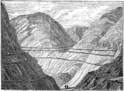
Fig. 62.—Parallel roads of Glen Roy.
According to the description of Sir Charles Lyell, "Glen Roy is situated in the western Highlands, about ten miles north of Fort William, near the western end of the great glen of Scotland, or Caledonian Canal, and near the foot of the highest of the Grampians, Ben Nevis. Throughout nearly its whole length, a distance of more than ten miles, three parallel roads or shelves are traced along the steep sides of the mountains, each maintaining a perfect horizontality, and continuing at exactly the same level on the opposite sides of the glen. Seen at a distance they appear like ledges, or roads, cut artificially out of the sides of the hills; but when we are upon them, we can scarcely recognize their existence, so uneven is their surface and so covered with boulders. They are from ten to sixty feet broad, and merely differ from the side of the mountain by being somewhat less steep.
“On closer inspection, we find that these terraces are stratified in the ordinary manner of alluvial or littoral deposits, as may be seen at those points where ravines have been excavated by torrents. The parallel shelves, therefore, have not been caused by denudation, but by the deposition of detritus, precisely similar to that which is dispersed in smaller quantities over the declivities of the hills above. These hills consist of clay-slate, mica-schist, and granite, which rocks have been worn away and laid bare at a few points immediately above the parallel roads. The lowest of these roads is about 850 feet above the level of the sea, and the next about 212 feet higher, and the third 82 feet above the second. There is a fourth shelf, which occurs only in a contiguous valley called Glen Gluoy, which is twelve feet above the highest of all the Glen Roy roads, and consequently about 1,156 feet above the level of the sea. One only, the lowest of the three roads of Glen Roy, is continued through Glen Spean, a large valley with which Glen Roy unites. As the shelves, having no slope towards the sea like ordinary river terraces, are always at the same absolute height, they become continually more elevated above the river in proportion as we descend each valley; and they at length terminate very abruptly, without any obvious cause, or any change either in the shape of the ground or in the composition or hardness of the rocks.” [CS]
Early in his career Charles Darwin studied these ancient beaches, and ascribed them to the action of the sea during a period of continental subsidence. In this view he was supported by the majority of geologists until the region was visited by Agassiz, who saw at once the true explanation. If these were really sea-beaches, similar deposits should be found at the same elevation on other mountains than those surrounding Glen Roy. Their absence elsewhere points, therefore, to some local cause, which was readily suggested to the trained eye of one like Agassiz, then fresh from the study of Alpine glaciers, who saw that these beaches were formed upon the margin of temporary lakes, held back during the Glacial period (as the Merjelen See now is) by a glacier which came out of one glen and projected itself directly across the course of another, and thus obstructed its drainage. The glacier of Glen Spean had pushed itself across Glen Roy, as the great Aletsch Glacier in Switzerland now pushes itself across the little valley behind the Eggishorn.
CHAPTER VIII.
RELICS OF MAN IN THE GLACIAL PERIOD.
In Glacial Terraces of the United States.
Although the first clear evidence of glacial man was discovered in Europe, the problem is so much simpler on the Western Continent that we shall find it profitable to study the American facts first. We will therefore present a summary of them at once, and then proceed to the more obscure problems of European archæology.
The first definite discovery of human relics clearly connected with, glacial deposits in America, and of the same age with them, was made by Dr. C. C. Abbott, at Trenton, N. J., in the year 1875. The city of Trenton is built upon a delta terrace about three miles wide which occurs at the head of tide-water on the Delaware River. This terrace bears every mark of having been deposited by a torrential stream which came down the valley during the closing period of the great Ice age. The material of which the terrace consists is all water-worn. According to the description of Professor N. S. Shaler:
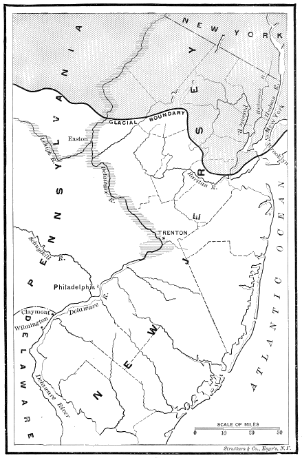
Fig. 63.—The glaciated portion is shaded. The shading on the Lehigh and Delaware Rivers indicates glacial terraces, which are absent from the Schuylkill.
“The general structure of the mass is neither that of ordinary boulder-clay nor of stratified gravels, such as are formed by the complete rearrangement by water of the elements of simple drift-deposits. It is made up of boulders, pebbles, and sand, varying in size from masses containing one hundred cubic feet or more to the finest sand of the ordinary sea-beaches. There is little trace of true clay in the deposit; there is rarely enough to give the least trace of cementation to the masses. The various elements are rather confusedly arranged; the large boulders not being grouped on any particular level, and their major axes not always distinctly coinciding with the horizon. All the pebbles and boulders, so far as observed, are smooth and water-worn, a careful search having failed to show evidence of distinct glacial scratching or polishing on their surfaces. The type of pebble is the subovate or discoidal, and though many depart from this form, yet nearly all observed by me had been worn so as to show that their shape had been determined by running water. The materials comprising the deposit are very varied, but all I observed could apparently with reason be supposed to have come from the extensive valley of the river near which they lie, except perhaps the fragments of some rather rare hypogene rocks.”
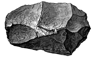
Fig. 64.—Palæolith found by Abbott in New Jersey, slightly reduced.
A conclusive proof of the relation of this Trenton delta terrace to the Glacial period is found in the fact that the gravel deposit is continuous with terraces extending up the trough of the valley of the Delaware to the glaciated area and beyond. As, however, the descent of the river-bed is rapid (about four feet to the mile) from the glacial border down to tide-water, the terrace is not remarkably high, being only about fifteen or twenty feet above the present flood-plain. But it is continuous, and similar in composition with the great enlargement in the delta at Trenton. Without doubt, therefore, the deposit represents the overwash gravel of the Glacial period.
Fortunately for science, Dr. C. C. Abbott, whose tastes for archæological investigations were early developed, had his residence upon the border of this glacial delta terrace at Trenton, and as early as 1875 began to find rough-stone implements of a peculiar type in the talus of the bank where the river was undermining the terrace. In turning his attention to the numerous fresh exposures of gravel made by railroad and other excavations during the following year, he found several of the implements in undisturbed strata, some of which were sixteen feet below the surface. Since that time he has continued to make discoveries at various intervals. In 1888 he had found four hundred implements of the palæolithic type at Trenton, sixty of which had been taken from recorded depths in the gravel, two hundred and fifty from the talus at the bluff facing the river, and the remainder from the surface, or derived from collectors who did not record the positions or circumstances under which they were found.

Fig. 65.—Section across the Delaware River at Trenton. New Jersey: a, a, Philadelphia red gravel and brick-clay (McGee’s Columbia deposit); b. b, Trenton gravel, in which the implements are found: c, present flood-plain of the Delaware River (after Lewis). (From Abbott’s Primitive Industry.)
The material from which the implements at Trenton are made is argillite—that is, a clay slate which has been so metamorphosed as to be susceptible of fracture, almost like flint. It is, however, by no means capable of being worked into such delicate forms as flint is. But as it is the only material in the vicinity capable of being chipped, prehistoric men of that vicinity were compelled to make a virtue of necessity and use the inferior material. Of all the implements found by Dr. Abbott in the gravel, only one was flint; while upon the surface innumerable arrow-heads of flint have been found. The transition, also, in the type of implements is as sudden as that in the kind of material of which they are made. Below the superficial deposit of black soil, extending down to the depth of about one foot, the modern Indian flint implements entirely disappear, and implements of palæolithic type only are found.
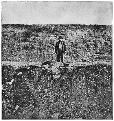
Fig. 66.—Section of the Trenton gravel in which the implements described in the text are found. The shelf on which the man stands is made in process of excavation. The gravel is the same above and below (photograph by Abbott).
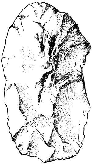
Fig. 67.—Face view of argillite implement, found by Dr. C. C. Abbott, in 1876, at Trenton, New Jersey, in gravel, three feet from face of bluff, and twenty-two feet from the surface (No. 10,985) (Putnam).
In the year 1882, after I had traced the glacial boundary westward from the Delaware River, across the States of Pennsylvania, Ohio, and Indiana, I was struck with the similarity between the terrace at Trenton and numerous terraces which I had attributed to the Glacial age in Ohio and the other States. It adds much to the interest of subsequent discoveries to note that in 1884, in my report to the Western Reserve Historical Society upon the glacial boundary of Ohio, I wrote as follows:
“The gravel in which they [Dr. Abbott’s implements] are found is glacial gravel deposited upon the banks of the Delaware when, during the last stages of the Glacial period, the river was swollen with vast floods of water from the melting ice. Man was on this continent at that period when the climate and ice of Greenland extended to the mouth of New York Harbor. The probability is, that if he was in New Jersey at that time, he was also upon the banks of the Ohio, and the extensive terrace and gravel deposits in the southern part of our State should be closely scanned by archæologists. When observers become familiar with the rude form of these palæolithic implements, they will doubtless find them in abundance. But whether we find them or not in this State [Ohio], if you admit, as I am compelled to do, the genuineness of those found by Dr. Abbott, our investigation into the glacial phenomena of Ohio must have an important archæological significance, for they bear upon the question of the chronology of the Glacial period, and so upon that of man’s appearance in New Jersey.”
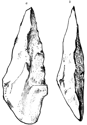
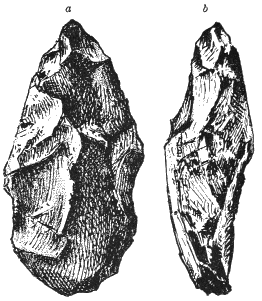
Fig. 68.—Argillite implement found by Dr. C. C Abbott, March, 1879, at A. K. Rowan’s farm, Trenton, New Jersey, in gravel sixteen feet from surface: a, face view; b, side view (No. 11,286) (Putnam). Fig. 69.—Chipped pebble of black chert, found by Dr. C. L. Metz. October, 1885, at Madisonville, Ohio, in gravel eight feet from surface under clay: a, face view; b, side view.
The expectation of finding evidence of preglacial man in Ohio was justified soon after this (in 1885), when Dr. C L. Metz, while co-co-operating with Professor F. W. Putnam, of the Peabody Museum, Cambridge, Mass., in field work, discovered a flint implement of palæolithic type in undisturbed strata of the glacial terrace of the Little Miami River, near his residence at Madisonville, Ohio. In 1887 Dr. Metz found another implement in the terrace of the same river, at Loveland, about twenty-five miles farther up the stream. The implement at Madisonville occurred eight feet below the surface, and about a mile back from the edge of the terrace; while that at Loveland was found in a coarser deposit, about a quarter of a mile back from the present stream, and thirty feet below the surface. Mastodon-bones also were discovered in close proximity to the implement at Loveland.
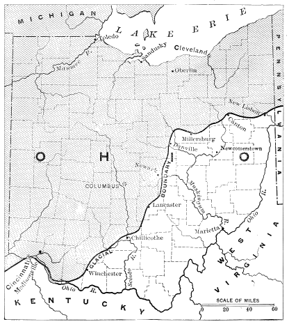
Fig. 70.
Interest in these investigations was still further increased by the report of Mr. Hilborne T. Cresson, of Philadelphia, that in 1886, with my map of the glaciated region in hand, he had found an implement of palæolithic type in undisturbed strata of the glacial terrace bordering the East Branch of White River, near the glacial boundary at Medora, Jackson County, Ind. The terrace was about fifty feet above the flood-plain of the river.
Later still, in October, 1889, Mr. W. C. Mills, of Newcomerstown, Tuscarawas County, Ohio, found in that town a finely shaped flint implement sixteen feet below the surface of the terrace of glacial gravel which lines the margin of the Tuscarawas Valley.[CT] Mr. Mills was not aware of the importance of this discovery until meeting with me some months later, when he described the situation to me, and soon after sent the implement for examination. In company with Judge C. C. Baldwin, President of the Western Reserve Historical Society, and several others, a visit was made to Mr. Mills, and we carefully examined the gravel-pit in which the implement occurred, and collected evidence which was abundant to corroborate all his statements. The implement in question is made from a peculiar flint which is found in the Lower Mercer limestone, of which there are outcrops a few miles distant, and it resembles in so many ways the typical implements found by Boucher de Perthes, at Abbeville, that, except for the difference in the material from which it is made, it would be impossible to distinguish it from them. The similarity of pattern is too minute to have originated except from imitation.
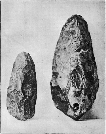
Fig. 71.—The smaller is the palæolith from Newcomerstown, the larger from Amiens (face view), reduced one half in diameter.
In 1877, a year after the discoveries by Dr. Abbott in New Jersey, some rude quartz implements were discovered by Professor N. H. Winchell in the glacial terraces of the upper Mississippi, in the vicinity of Little Falls, Morrison County, Minn. This locality was afterwards more fully explored by Miss Franc E. Babbitt, who succeeded in finding so large a number of the implements as to set at rest all question concerning their human origin. According to Mr. Warren Upham, the glacial flood-plain of the Mississippi is here about three miles wide, with an elevation of from twenty-five to thirty feet above the river. It is in a stream near the bottom of this glacial terrace that the most of Miss Babbitt’s discoveries were made, and Mr. Upham has pretty clearly shown that the gravel of the terrace overlying them was mostly deposited while the ice-front was still lingering about sixty miles farther north, in the vicinity of Itasca Lake.[CU]
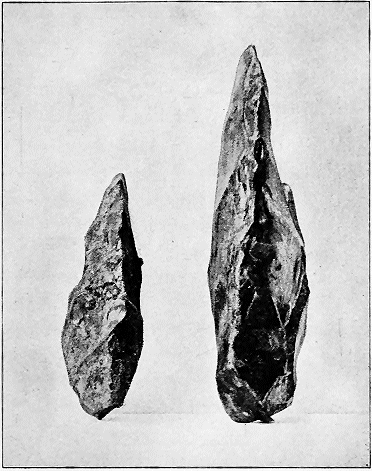
Fig. 72.—Edge view of the preceding.

Fig. 73.—Section across the Mississippi Valley at Little Falls, Minnesota, showing the stratum in which chipped quartz fragments were found by Miss F. E. Babbitt, as described in the text (Upham).
Up to this time the above are all the instances in which the relics of man are directly and indubitably connected with deposits of this particular period east of the Rocky Mountains. Probably it is incorrect to speak of these as preglacial, for the portion of the period at which the deposits incorporating human relics were made is well on towards the close of the great Ice age, since these terraces were, in some cases, and may have been in all cases, deposited after the ice-front had withdrawn nearly, if not quite, to the water-shed of the St Lawrence basin. It may be difficult to demonstrate this with reference to the gravel deposits at Trenton, Madisonville, and Medora, but it is evident at a glance in the case of Newcomerstown and Little Falls.
That the implement-bearing gravel of Trenton, N. J., belongs to the later stages of the Glacial period is evident from its relation to what Professor H. Carvill Lewis called “the Philadelphia red gravel and brick-clay,” but which, from its large development in the District of Columbia at Washington, is called by Mr. McGee the “Columbia deposit.” The city of Philadelphia is built upon this formation in the Delaware Valley, and the brick for its houses is obtained from it; the cellar of each house ordinarily furnishing clay enough for its brick walls. This clay is of course a deposit in comparatively still water, which would imply deposition during a period of land subsidence. But that it was ice-laden water which flooded the banks is shown by the frequent occurrence of large blocks of stone in the deposits, such as could have been transported only in connection with floating ice. The boulders in the Columbia formation clearly belong to the individual river valleys in which they are found, and doubtless are to be connected with the flooded condition of those valleys when, by means of a northerly subsidence, the gradient of the streams was considerably less than now.
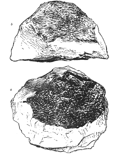
Fig. 74.—Quartz implement, found by Miss F. E. Babbitt, 1878, at Little Falls, Minnesota, in modified drift, fifteen feet below surface: a, face view; b, profile view. The black represented on the cut is the matrix of the quartz vein (No. 31,323) (Putnam).
There is some difference of opinion in respect to the extent of this subsidence, and, indeed, respecting the height attained by the Philadelphia brick-clay, or McGee’s Columbia deposit. Professor Lewis (whose residence was at Philadelphia, and who had devoted much time to field observations) insisted that the deposit could not be found higher than from 180 to 200 feet above the immediate flood-plain of the river valleys where they occur. But, without entering upon this disputed question, it is sufficient to consider the bearing of the facts that are accepted by all—namely, that towards the close of the Glacial period there was a marked subsidence of the land on the eastern coast of North America, increasing towards the north.
Fully to comprehend the situation, we need to bring before the mind some of the indirect effects of the Glacial period in this region. The most important of these was the necessary projection of subglacial conditions over a considerable belt of territory to the south of that actually reached by glacial ice; so that, while there are no clear indications of the existence of local glaciers in the Appalachian Mountains south of the central part of Pennsylvania, there are many indications of increased snow-fall upon the mountains, connected with prolonged winters and with a great increase of spring floods and ice-gorges upon the annual breaking up of winter.
These facts have been stated in detail by Mr. McGee,[CV] from whose report it appears that, on the Potomac at Washington, the surface of the Columbia deposit is 150 feet above tide, and that the deposit itself contains many boulders, some of which are as much as two or three feet in diameter. These are mingled with the gravel in such a way as to show that they must have been brought down by floating ice from the head-waters of the Potomac when the winters were much more severe than now. That this deposit is properly the work of the river is shown by the entire absence of marine shells.
According to Mr. McGee, also, there is a gradual decrease in the height of these delta terraces of the Columbia period as they recede from the glacial boundary—that at the mouth of the Susquehanna being 245 feet, that of the Potomac 140 feet, that on the Rappahannock 125, that on the James 100, and that on the Roanoke 75; while the size of the transported boulders along the streams also gradually diminishes in the same order. During the Columbia period the Susquehanna River transported boulders fifty times the size now transported, while the Potomac transported them only up to twenty times, the Rappahannock only ten times, the James only five, and the Roanoke only two or three times the size of those now transported. This progressive diminution, both in the extent of the deposit and in the coarseness of the material deposited by these rivers at about the time of the maximum portion of the Glacial period, is what would naturally be expected under the conditions supposed to exist in connection with the great Ice age, and is an important confirmation of the glacial theory.
That the period of subsidence and more intense glacial conditions during which the Columbia deposits took place, preceded, by a long interval, the deposition of the gravel terraces at Trenton, N. J., and the analogous deposits in the Mississippi Valley where palæolithic implements have been found, is evident enough. The Trenton gravel was deposited in a recess in the Columbia deposit which had been previously worn out by the stream. Indeed, in every place where opportunity offers for direct observation the Trenton gravel is seen to be distinctly subsequent to the other. It was not buried by the Philadelphia red gravel and brick-clay, but to a limited degree overlies and buries it.
The data for measuring the absolute length of time between these two stages of the Glacial period are very indefinite. Mr. McGee, however, supposes that since the Columbia period a sufficient time has elapsed for the falls of the Susquehanna to recede more than twenty miles and for those of the Potomac eighteen miles, and this through a rock which is exceedingly obdurate. But, in channels opening, as these do, freely outward, it is difficult to tell in what epochs the erosion has been principally performed, since there are no buried channels, as in the glaciated area, enabling us to determine whether or not much of the eroding work of the river may have been accomplished in preglacial times.
The lapse of time which, upon the least calculation, separates the Columbia epoch from the Trenton, gives unusual importance to any discovery of palæolithic implements which may be made in the earlier deposits. We are bound, therefore, to consider with special caution the reported discovery of an implement in these deposits at Claymont, Delaware. The discovery was made by Dr. Hilborne T. Cresson, on July 13, 1887, during the progress of an extensive excavation in constructing the Baltimore and Ohio Railroad, nineteen miles south of Philadelphia. The implement was from eight to nine feet below the surface. As there is so much chance for error of judgment respecting the undisturbed condition of the strata, and as there was so little opportunity for Dr. Cresson to verify his conclusion, we may well wait for the cumulative support of other discoveries before building a theory upon it; still, it will be profitable to consider the situation.
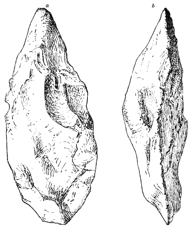
Fig. 75.—Argillite implement, found by H. T. Cresson, 1887, in Baltimore and Ohio Railroad cut, one mile from Claymont, Delaware, in Columbia gravel, eight to nine feet below the overlying clay bed: a, face view; b, side view (No. 45,726) (Putnam).
Both Mr. McGee and myself have visited the locality with Dr. Cresson, and there can be no doubt that the implement occurred underneath the Columbia gravel. The line of demarcation is here very sharp between that gravel and the decomposed strata of underlying gneiss rock, which appears in our illustration as a light band in the middle of the section exposed. Some large boulders which could have been moved only in connection with floating ice are found in the overlying deposit near by. This excavation is about one mile and a half west of the Delaware River, and about 150 feet above it, being nearly at the uppermost limit of the Columbia deposit in that vicinity.
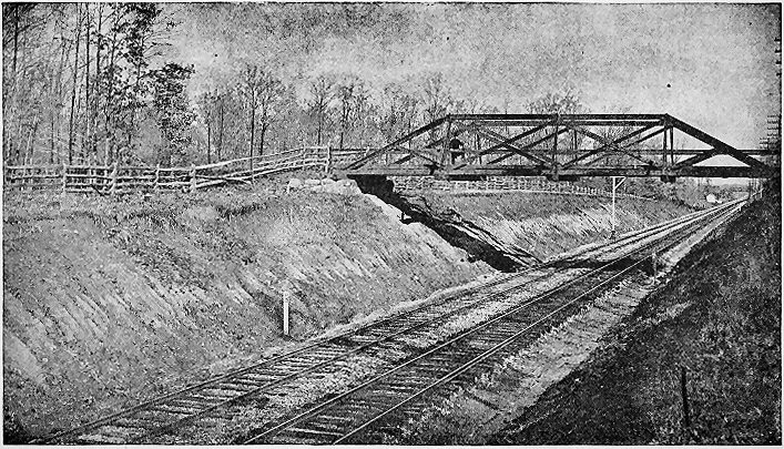
Fig. 76.—General section of Baltimore and Ohio cut, near Claymont, Delaware, where Mr. Cresson found palæolithic implements figured in the text (from photograph by Cresson).
The age of these deposits in which implements have been found at Claymont and at Trenton will be referred to again when we come to the specific discussion of the date of the Glacial period. It is sufficient here to bring before our minds clearly, first, the fact that this at Claymont is connected with the river floods accompanying the ice at its time of maximum extension, and when there was a gradually increasing or differential depression of the country to an unknown extent to the northward.
Two radically different theories are presented to account for the deposits variously known as the Columbia gravel and the Philadelphia brick-clay. Mr. McGee, in the monograph above referred to, supposes them to have been deposited during a period of a general subsidence of the coast-line; so that they took place at about tide-level. Mr. Upham, on the other hand, supposes them to have been deposited during the period of general elevation to whose influence he mainly attributes the Glacial period itself. In his view much of the shallow sea-bottom adjoining the present shore off from Delaware and Chesapeake Bays was then a land-surface, and the Hudson, the Delaware, and the Susquehanna Rivers, coming down from the still higher elevations of the north, flowed through extensive plains so related to the northern areas of elevation that deposition was occurring in their valleys, owing in part to the flooded condition of the streams, in part to the differential elevation, and in part to the superabundance of silt and other débris furnished by the melting ice-sheet in the head-waters of these streams.
The deposits of Trenton gravel occurred much later, at a time when the ice had melted far back towards the head-waters of the Delaware, and after the land had nearly resumed its present relations of level, if indeed it had not risen northward to a still greater relative height.
As would be expected from the climatic conditions accompanying the Glacial epoch, man’s companions in the animal world were very different during the period when the high-level river gravels of America were forming from those with which he is now associated. From the remains actually discovered, either in these gravels or in close proximity to them, we infer that, while the mastodon was the most frequent of the extinct quadrupeds with which man then had to contend in that region, he must have been familiar also with the walrus, the Greenland reindeer, the caribou, the bison, the moose, and the musk ox.
In the Glacial Terraces of Europe.
The existence of glacial man in Europe was first determined in connection with the high-level river gravels already described in the valley of the Somme, situated in Picardy in the northern part of France. Here in 1841 Boucher de Perthes began to discover rudely fashioned stone implements in undisturbed strata of the gravel terraces, whose connection with the Glacial period we have already made clear. But for nearly twenty years his discoveries were ignored by scientific men, although he made persistent efforts to get the facts before them, and published a full account of them with illustrations as early as 1847. Some suggested fraud on the part of the workmen; others without examination declared that the gravel must have been disturbed; while others, still, denied altogether the artificial character of the implements.

Fig. 77.—Section across valley of the Somme: 1, peat, twenty to thirty feet thick, resting on gravel, a; 2, lower-level gravels, with elephant-bones and flint implements, covered with river-loam twenty to forty feet thick; 3, upper-level gravels, with similar fossils covered with loam, in all, thirty feet thick; 4, upland-loam, five to six feet thick; 5, Eocene-Tertiary.
At length, Dr. Regillout, an eminent physician residing at Amiens, about forty miles higher up the Somme than Abbeville, visited Boucher de Perthes, and, upon seeing the similarity between the gravel terraces at Abbeville and Amiens, returned home to look for similar implements in the high-level gravel-pits at St. Acheul, a suburb of Amiens. Almost immediately he discovered flint implements there of the same pattern with those at Abbeville, and in undisturbed strata of the gravel terrace, where it rested on the original chalk formation, at a height of 90 feet above the river. In the course of four years, Dr. Regillout found several hundred of these implements, and in 1854 published an illustrated report upon the discoveries.
Still the scientific world remained incredulous until the years 1858 and 1859, when Dr. Falconer, Mr. Prestwich, Mr. John Evans, Mr. Flower, Sir Charles Lyell, of England, and MM. Pouchet and Gaudry, of France, visited Abbeville and Amiens, and succeeded in making similar discoveries for themselves. Additional discoveries at St. Acheul have continued up to the present time whenever excavations have gone on at the gravel-pits. Mr. Prestwich estimates that there is an implement to every cubic metre of gravel, and says that he himself has brought away at different times more than two hundred specimens, and that the total number found in this one locality can hardly be under four thousand. “The gravel-beds are on the brow of a hill 97 feet above the river Somme,” and besides the relics of man contain numerous fluviatile and land shells together with “teeth and bones of the mammoth, rhinoceros, horse, reindeer, and red deer, but not of the hippopotamus,”[CW] bones of the latter animal being found here only in the gravels of the lower terraces, where they are less than thirty feet above the river, and mark a considerably later stage in the erosion of the valley. While many of the implements found at Amiens seem to have been somewhat worn and rolled, “others are as sharp and fresh as when first made.... The bedding of the gravel is extremely irregular and contorted, as though it had been pushed about by a force acting from above; and this, together with the occurrence of blocks of Tertiary sandstone of considerable size, leads to the inference that both are due to the action of river-ice. In the Seine Valley blocks of still larger size, and transported from greater distances, are found in gravels of the same age.”
“Flint implements are found under similar conditions in many of the river-valleys of other parts of France, especially in the neighbourhood of Paris; of Mons in Belgium; in Spain, in the neighbourhood of Madrid, in Portugal, in Italy, and in Greece; but they have not been discovered in the drift-beds of Denmark, Sweden, or Russia, nor is there any well-authenticated instance of the occurrence of palæoliths in Germany.”[CX]
When once the fact had been established that man was in northern France at the time of the deposition of the high-level gravels of the Somme and the Seine, renewed attention was directed to terraces of similar age in southern England. One of these is that upon which the city of London is built, and which, according to Lyell’s description, “extends from above Maidenhead through the metropolis to the sea, a distance from west to east of fifty miles, having a width varying from two to nine miles. Its thickness ranges commonly from five to fifteen feet.”[CY]
For a long time geologists had been familiar with the fact that these terraces of the Thames contain the remains of numerous extinct animals, among which are included the mammoth and a species of rhinoceros. Upon directing special attention to the subject, it was found that, at various intervals, the remains of man, also, had been reported from the same deposits. As long ago as 1715 Mr. Conyers discovered a palæolithic implement, in connection with the skeleton of an elephant, at Black Mary’s, near Gray’s Inn Lane, London. This implement is preserved in the British Museum, and closely resembles typical specimens from the gravel at Amiens. Other implements of similar character have been found in the valley of the Wey near Guilford, also in the valley of the Darent, near Whitstable in Kent, and between Heme Bay and the Reculvers. While the exact position of these implements in the gravel had not been so positively noted as in the case of those found at Amiens and Abbeville, there can be little doubt that man, in company with the extinct animals mentioned, inhabited the valley of the Thames at a period when its annual floods spread over the whole terrace-plain upon which the main part of London is built.
In the valley of the Ouse, however, near Bedford, the discovery of palæolithic implements in the gravel terraces connected with the Glacial period and in intimate association with bones of the elephant, rhinoceros, hippopotamus, and other extinct animals, has been as fully established as in the valley of the Somme. The discoveries here were first made in the year 1860, by Mr. James Wyatt, in a gravel-pit at Biddenham, two miles northwest of Bedford. Two flint implements were thrown out by workmen in one day from undisturbed strata thirteen feet below the surface, and numerous other specimens have since been found in a similar situation.
The valley of the Ouse is bordered on either side by sections of a superficial blanket of glacial drift containing many transported boulders of considerable size. The valley is here about two miles wide, and ninety feet deep. The gravel deposit, however, in which the implements were found, is only about thirty feet above the present level of the river, and hence represents the middle period of the work of the river in erosion.
Another locality in England in which similar discoveries have been made, is at Hoxne, about five miles from Diss, in Suffolk County. Like that in the valley of the Thames, however, the implements were found a long time before the significance of the discovery was recognized. Mr. John Frere reported the discovery to the Society of Antiquaries in 1801, and gave some of the implements both to the society and to the British Museum, in whose collections they are still preserved. The implements are of the true palæolithic type, and existed in such abundance, and were so free from signs of wear, that the conclusion seemed probable that a manufactory of them had been uncovered. As many as five or six to the square yard are said to have been found. Indeed, their numbers were so great that the workmen “had emptied baskets of them into the ruts of the adjoining road before becoming aware of their value.”
The deposit in which they are found is situated in the valley of Gold Brook, a tributary of the Waveney. The implements occurred about twelve feet below the surface, in fresh-water deposits, filling a hollow eroded in the glacial deposit covering that part of England. This, therefore, is clearly either of post-glacial or of late glacial age.
Still another locality in which similar palæolithic implements were found in undisturbed gravel of this same age in eastern England is Icklingham, in the valley of the Lark, where the situation is quite similar to that already described at Bedford, on the Ouse.
The last place we will stop to mention in England which was visited by palæolithic man, during or soon after the Glacial epoch, is to be found in the vicinity of Southampton. At this time the Isle of Wight was joined to the mainland, and not improbably England itself to the Continent. The river, then flowing through the depression of the Solent and the Southampton Water, occupied a much higher level than now, leaving terraces along the shore at various places, in which the tools of palæolithic man have been discovered.
Though these are the best authenticated discoveries connecting man with the Glacial period in England, they are by no means the only probable cases. Almost every valley of southern England furnishes evidence of a similar but less demonstrative character.
In Cave Deposits.
The discovery of the remains of man in the high-level river-gravels deposited near the close of the Glacial period led to a revision of the evidence which had from time to time been reported connecting the remains of man with those of various extinct animals in cave deposits both in England and upon the Continent.
The British Isles.
As early as 1826, Rev. J. MacEnery, a Roman Catholic priest residing near Torquay, in Devonshire, England, had made some most remarkable discoveries in a cavern at Kent’s Hole, near his home; but, owing to his early death, and to the incredulity of that generation of scientific men, his story was neither credited nor published till 1859. About this time, a new cave having been discovered not far away, at Brixham, the best qualified members of the Royal Society (Lyell, Phillips, Lubbock, Evans, Vivian, Pengelly, Busk, Dawkins, and Sanford) were deputed to see that it was carefully explored. Mr. Pengelly, who had had twenty years’ experience in similar explorations, directed and superintended the work. Every portion of the contents was examined with minutest care. Kent’s Hole is “180 to 190 feet above the level of mean tide, and about 70 feet above the bottom of the valley immediately adjacent.”[CZ] In one chamber the excavation was about sixty feet square. The contents were arranged in the following order:
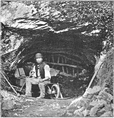
Fig. 78.—Mouth of Kent’s Hole.
1. A surface of dark earth a few inches thick, containing Roman pottery, iron and bronze spear-heads, together with polished stone weapons. There were, too, in this stratum bones of cows, goats, and horses, mingled with large quantities of charcoal.
2. Below this was a stalagmite floor from one to three feet thick, formed by the dripping of lime-water from the roof.
3. Under this crust of stalagmite was a compact deposit of red earth, from two to thirteen feet thick.[DA] Flint implements of various kinds and charcoal were also found at different depths; also an awl, or piercer; a needle with the eye large enough to admit small pack-thread; and three harpoon-heads made out of bone and deer’s horn.
4. Flint implements were also obtained in a conglomerate (breccia) still below this. The fossil bones in this cave belonged to the same species of animals as those discovered in a cave near Wells.
The Brixham cave occurs near the small village of that name, not far from Torquay. The entrance to it is about ninety-five feet above high water. Its deposits, in descending order, are: 1. Stalagmitic floor from six to twelve or fifteen inches in thickness. 2. A thin breccia of limestone fragments cemented together by carbonate of lime. This had accumulated about the mouth, so as to fill up the entrance. 3. A layer of blackish earth about one foot in thickness 4. A deposit of from two to four feet thick, consisting of clayey loam, mingled with fragments of limestone, from small bits up to rocks weighing a ton. Bounded pebbles of other material were also occasionally met with. 5. Shingle consisting of rounded pebbles largely of foreign material.
All these strata, except the third, contained fossils of some kind, but the fourth was by far the richest repository. Among the bones found are those of the mammoth, the woolly rhinoceros, the horse, the ox, the reindeer, the cave-lion, the cave-hyena, and the cave-bear. Associated with these remains a number of worked flints was found. In one place the bones of an entire leg of a cave-bear occurred in such a position as to show that they must have been bound together by the ligaments when they were buried. Immediately below these bones a flint implement was found.[DB]
The hyena’s den, at Wookey Hole, near Wells, in Somerset, was carefully explored by Professor Boyd Dawkins, who stood by and examined every shovelful of material as it was thrown out.
This cave alone yielded 35 specimens of palæolithic art, 467 jaws and teeth of the cave-hyena, 15 of the cave lion, 27 of the cave-bear, 11 of the grizzly bear, 11 of the brown bear, 7 of the wolf, 8 of the fox, 30 of the mammoth, 233 of the woolly rhinoceros, 401 of the horse, 16 of the wild ox, 30 of the bison, 35 of the Irish elk, and 30 of the reindeer (jaws and teeth only).
In Derbyshire numerous caves were explored by Professor Dawkins at Cress well Crags, which, in addition to flint implements and the remains of the animals occurring in the Brixham cave, yielded the bones of the machairodus, an extinct species of tiger or lion which lived during the Tertiary period.
The Victoria cave, near Settle, in west Yorkshire, is the only other one in England which we need to mention. In this there were no remains found which could be positively identified as human, but the animal remains in the lower strata of the cave deposit were so different from those in the upper bed as to indicate the great lapse of time which separated the two. This cave is 1,450 feet above the sea-level, and there were found in the upper strata of the floor, down to a depth of from two to ten feet, many remains of existing animals. Then, for a distance of twelve feet, there occurred a clay deposit, containing no organic remains whatever, but some well-scratched boulders. Below this was a third stratum of earth mingled with limestone fragments, at the base of which were numerous remains of the mammoth, rhinoceros, hippopotamus, bison, hyena, etc. One bone occurred which was by some supposed to be human, but by others to have belonged to a bear. This lower stratum is, without much doubt, preglacial, and the thickness of the deposit intervening between it and the upper fossiliferous bed is taken by some to indicate the great lapse of time separating the period of the mammoth and rhinoceros in England from the modern age. The scratched boulders in the middle stratum of laminated clay, would indicate certainly that the material found its way into the cave during the Glacial epoch, when ice filled the whole valley of the Ribble, which flows past the foot of the hill, and whose bed is 900 feet below the mouth of the cave.
In North Wales the Vale of Clwyd contains numerous caves which were occupied by hyenas in preglacial times and with their bones are associated those of the mammoth, the rhinoceros, the hippopotamus, the cave-lion, the cave-bear, and various other animals. Flint implements also were found in the cave at Cae Gwyn, near the village of Tremeirchon, on the eastern side of the valley, opposite Cefn, and about four miles distant. We have already given an illustration of the Cefn cave (see page 148). It will be observed that this valley of the Clwyd opens to the north, and has a pretty rapid descent to the sea from the Welsh mountains, and was in position to be obstructed by the Irish Sea glacier, so as to have been occupied at times by one of the characteristic marginal lakes of the Glacial period. It is evident also that the northern ice prevailed over the Welsh ice for a considerable portion of the lower part of the valley; for northern drift is the superficial deposit upon the hills on the sides of the valley up to a height of over 500 feet. From the investigations of Mr. C. E. De Rance, F. G. S.,[DC] it is equally clear also that the northern drift, which until lately sealed up the entrance of the cave, was subsequent to its occupation by man, and this was the opinion formed by Sir Archibald Geikie, Director General of the Geological Survey of the United Kingdom, as the result of special investigations which he made of the matter.[DD]
From the caves in the Vale of Clwyd as many as 400 teeth of rhinoceros, 500 of horse, 180 of hyena, and 15 of mammoth have been taken. A section of the cave deposits in the cave at Cae Gwyn is as follows:
“Below the soil for about eight feet a tolerably stiff boulder-clay, containing many ice-scratched boulders and narrow bands and pockets of sand. Below this about seven feet of gravel and sand, with here and there bands of red clay, having also many ice-scratched boulders. The next deposit was a laminated brown clay, and under this was found the bone-earth, a brown, sandy clay with small pebbles and with angular fragments of limestone, stalagmites, and stalactites. During the excavations it became clear that the bones had been greatly disturbed by water action; that the stalagmite floor, in parts more than a foot in thickness, and massive stalactites, had also been broken and thrown about in all positions; and that these had been covered afterwards by clays and sand containing foreign pebbles. This seemed to prove that the caverns, now 400 feet above ordnance datum, must have been submerged subsequently to their occupation by the animals and by man. In Dr. Hicks’s opinion, the contents of the cavern must have been disturbed by marine action during the great submergence in mid-glacial times, and afterwards covered by marine sands and by an upper boulder-clay, identical in character with that found at many points in the Vale of Clwyd. The paleontological evidence suggests that the deposits in question are not preglacial, but may be equivalent to the Pleistocene deposits of our river-valleys.”[DE]
If the views of Professor Lewis and Mr. Kendall are correct concerning the unity of the Glacial period in England, the shelly and sandy deposits connected with these Clwydian caves at an elevation of 400 feet or more would be explained in connection with the marginal lakes which must have occupied the valley during both the advance and the retreat of the ice-front; the shells having been carried up from the sea-bottom by the ice-movement, after the manner supposed in the case of those at Macclesfield and Moel Tryfaen. If, therefore, the statements concerning the discovery of flint implements in this Cae Gwyn cave can be relied upon, this is the most direct evidence yet obtained in Europe of man’s occupation of the island during the continuance of the Glacial period.
In all these caves it is to be noted that there is a sharp line of demarcation between the strata containing palæolithic implements and those containing only the remains of modern animals. Palæolithic implements are confined to the lower strata, which in some of the caves are separated from the upper by a continuous bed of stalagmite, to which reference will be made when discussing the chronology of the Glacial period. The remains of extinct animals also are confined to the lower beds.
The caves which we have been considering in England are all in limestone strata, and have been formed by streams of water which have enlarged some natural fissures both by mechanical action in wearing away the rocks, and by chemical action in dissolving them. Through the lowering of the main line of drainage, caverns with a dry floor are at length left, offering shelter and protection both to man and beast. Oftentimes, but not always, some idea of the age of these caverns may be obtained by observing the depth to which the main channel of drainage to which they were tributary has been lowered since their formation. But to this subject also we will return when we come specifically to discuss the chronological question.
The Continent.
Systematic explorations in the caves of Belgium were begun in 1833 by Dr. Schmerling, in the valley of the Meuse, near his residence in Liége. The Meuse is here bordered by limestone precipices 200 or more feet in height. Opening out from these rocky walls are the entrances to the numerous caverns which have rendered the region so famous. To get access to the most important of these, Dr. Schmerling had to let himself down over a precipice by a rope tied to a tree, and then to creep along on all-fours through intricate channels to reach the larger chambers which it was his object to explore. In the cave at Engis, on the left bank of the Meuse, about eight miles above Liége, he found a human skull deeply buried in breccia in company with many bones of the extinct animals previously stated to have been associated with man during the Glacial period. This so-called “Engis skull” was by no means apelike in its character, but closely resembled that of the average Caucasian man. But this established the association upon the Continent of man with some of the extinct animals of the Glacial period.
Fig. 79.—Engis skull, reduced (after Lyell.)
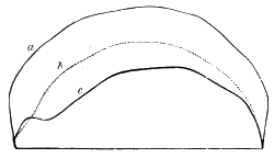
Fig. 80.—Comparison of forms of skulls: a, European; b, the Neanderthal man; c, a chimpanzee (after Lyell).
The vicinity of Liége has also furnished us another cavern whose contents are of the highest importance, ranking indeed as perhaps the most significant single discovery yet made. The cave referred to is on the property of the Count of Beauffort, in the commune of Spy, in the province of Namur in Belgium. For the facts relating to it we are indebted to Messrs: Lohest and Fraipont, the former Professor of Geology and the latter of Anatomy in the University of Liége. The exploration of the cave was made in 1886, and the full report with illustrations published in the following year in Archives de Biologie.[DF] The significance of this discovery is enhanced by the light it sheds upon and the confirmation it brings to the famous Neanderthal skull and others of similar character, which for a long time had been subjects of vigorous discussion. Before describing it, therefore, we will give a brief account of the previous discoveries.
The famous Neanderthal skull was brought to light in 1857 by workmen in a limestone-quarry, near Düsseldorf, in the valley of the Neander, a small tributary to the Rhine. By these workmen a cavern was opened upon the southern side of the winding ravine, about sixty feet above the stream and one hundred feet below the top of the cliff. The skull attracted much attention from its supposed possession of many apelike characteristics; indeed, it was represented by some to be a real intermediate link between man and the anthropoid apes. The accompanying cut enables one to compare the outline of the Neanderthal skull with that of a chimpanzee on the one hand and of the highly developed European on the other. The apelike peculiarities of this skull appear in its vertical depression, in the enormous thickness of the bony ridges just above the eyes, and in the gradual slope of the back part of the head, together with some other characteristics which can only be described in technical language; so that it was pronounced by the highest authorities the most apelike of human crania which had yet been discovered. Unfortunately, the jaw was not found. The capacity of the skull, however, was seventy-five cubic inches, which is far above that of the highest of the apes, being indeed equal to the average capacity of Polynesian and Hottentot skulls.[DG] Huxley well remarks that “so large a mass of brain as this would alone suggest that the pithecoid tendencies indicated by this skull did not extend deep into the organization.”
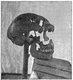
Fig. 81.—Skull of the Man of Spy. (From photograph.)
Upon extending inquiries, it was found that the Neanderthal type of skull is one which still has representatives in all nations; so that it is unsafe to infer that the individual was a representative of all the individuals living in his time. The skull of Bruce, the celebrated Scotch hero, was a close reproduction of the Neanderthal type; while, according to Quatrefages,[DH] the skull of the Bishop of Toul in the fourth century “even exaggerates some of the most striking features of the Neanderthal cranium. The forehead is still more receding, the vault more depressed, and the head so long that the cephalic index is 69-41.” The discovery of Messrs. Fraipont and Lohest adds much to our definite knowledge of the Neanderthal type of man, since the Belgic specimens are far more complete than any others heretofore found, there being in their collection two skulls, together with the jawbones and most of the other parts of the frame. In this case also there is no suspicion that the deposits had been disturbed, so as to admit any intrusion of human relics into the company of relics of an earlier age. According to M, Lohest, there were three distinct ossiferous beds, separated by layers of stalagmite. All the ossiferous beds contained the remains of the mammoth, but in the upper stratum they were few, and probably intrusive. The implements found in this were also of a more modern type. In the second stratum from the top numerous hearths were found with burnt wood and ashes, together with the bones of the rhinoceros, the horse, the mammoth, the cave-bear, and the cave-hyena, all of which were abundant, while there were also specimens of the Irish elk, the reindeer, the bison, the cave-lion, and several other species. In this layer also there were numerous implements of ivory, together with ornaments and some faint indications of carving upon the rib of a mammoth, besides a few fragments of pottery.
It was in the third, or lowest, of these beds that the skeletons were found. Here they were associated with abundant remains of the rhinoceros, the horse, the bison, the mastodon, the cave-hyena, and a few other extinct species. Flint implements also, of the “Mousterien” pattern (which, according to the opinion of the French archæologists, is characteristic of middle palæolithic times), were abundant Neither of the skeletons was complete, but they were sufficiently so to give an adequate idea of the type to which they belong, and one of the skulls is nearly perfect. According to M. Fraipont, “one of these skulls is apparently that of an old woman, the other that of a middle-aged man. They are both very thick; the former is clearly dolichocephalic (long-headed, index 70), the other less so. Both have very prominent eyebrows and large orbits, with low, retreating foreheads, excessively so in the woman. The lower jaws are heavy. The older has almost no projecting chin. The teeth are large, and the last molar is as large as the others. These points are characteristic of an inferior and the oldest-known race. The bones indicate, like those of the Neanderthal and Naulette specimens, small, square-shouldered individuals.” They were “powerfully built, with strong, curiously curved thigh-bones, the lower ends of which are so fashioned that they must have walked with a bend at the knees.” [DI]
Other crania from various Quaternary deposits in Europe seem to warrant the inference that this type of man was the prevalent one during the early part of the Palæolithic age. As long ago as 1700 a skull of this type was exhumed in Canstadt, a village in the neighbourhood of Stuttgart, in Würtemberg. This was found in coexistence with the extinct animals whose bones we have described as so often appearing in the high-level river-gravel of the Glacial age. But the importance of the discovery at Canstadt was not appreciated until about the middle of the present century. From the priority of the discovery, and of the discussion among German anthropologists concerning it, it has been thought proper, however, by some to give the name of this village to the race and call it the “Canstadt race.” But, whatever name prevails, it is important in our reading to keep in mind that the man of Canstadt, the man of Neanderthal, and the man of Spy are identical in type, and probably in age. Similar discoveries have been made in various other places. Among these are a lower jaw of the same type discovered in 1865 by M. Dupont, at Naulette, in the valley of the Lesse, in Belgium, and associated with the remains of extinct animals; a jawbone found in a grotto at Arcy; a fragment of a skull found in 1865 by Faudel, in the loess of Eguisheim, near Colmar; a skull at Olmo, discovered in 1863, in a compact clayey deposit forty-five feet below the surface; and a skull discovered in 1884 at Marcilly.