Front matter (continued 6)
Reading edition
M. Dupont has brought to light much additional testimony to glacial man from other caves in different parts of Belgium. In all he has explored as many as sixty. Three of these, in the valley of the Montaigle, situated about one hundred feet above the river, contained both remains of man and many bones of the mammoth and other associated animals, which had evidently been brought in for food.
In the hilly parts of Germany, also, and in Hungary, and even in the Ural Mountains in Russia, and in one of the provinces of Siberia, the remains of the rhinoceros, and most of the other animals associated with man in glacial times, have been found in the cave deposits which have been examined. Though it can not be directly proved that these animals were associated with man in any of these places, still it is interesting to see how wide-spread the animals were in northern Europe and Asia during the Glacial period.
Some northern animals, also, spread at this time into southern Europe—remains of the reindeer having been discovered on the south slope of the Pyrenees, but the remains of the mammoth, the woolly rhinoceros, and the musk ox, have not been found so far south.
African species of the elephant, however, seem at one time to have had free range throughout Spain, and the hippopotamus roamed in vast herds over the valleys of Sicily, while several species of pygmy elephants seem to be peculiar to the island of Malta.
In the case of all the cave deposits referred to (with possibly the exception of those of Victoria, England, and Cae Gwyn, Wales), the evidence of man’s existence during the Glacial period is inferential, and consists largely in the fact that he was associated with various extinct animals which did not long survive that period, or with animals that have since retired from Europe to their natural habitat in mountain-heights or high latitudes. The men whose remains are found in the high-level river-drift, and in the caverns described, were evidently not in possession of domestic animals, as their bones are conspicuous for their absence in all these places. The horse, which would seem to be an exception, was doubtless used for food, and not for service.
If we were writing upon the general subject of the antiquity and development of the human race, we should speak here in detail of several other caves and rock shelters in France and southern Europe, where remains of man belonging to an earlier period have been found. We should mention the rock shelter of Cro-Magnon in the valley of Vezère, as well as that of Mentone, where entire human skeletons were found. But it is doubtful if these and other remains from caves which might be mentioned belong in any proper sense to the Glacial period. The same remarks should be made also with reference to the lake-dwellings in Switzerland, of which so much has been written in late years. All these belong to a much later age than the river-drift man of whom we are speaking, and of whom we have such abundant evidence both in Europe and in America.
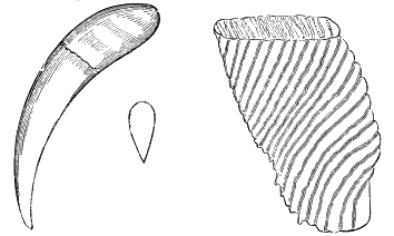
Fig. 82.—Tooth of Machairodus neogæus, × 16 (drawn from a cast). Fig. 83.—Perfect tooth of an Elephas, found in Stanislaus County, California, 18 natural size.
Extinct Animals associated with Man during the Glacial Period.
This is the proper place in which to speak more fully of the extinct animals which accompanied man in his earliest occupation of Europe and America, and whose remains are so abundant in the river-drift gravel and in the caves of England, in connection with the relics of man. Among these animals are
The Lion, which is now confined, to Africa and the warmer portions of Asia. But in glacial times a large species of this genus ranged over Europe from Sicily to central England.
The saber-toothed Tiger, with tusks ten inches long: (Machairodus latidens), is now extinct. This species was in existence during the latter part of the Tertiary period, but continued on until after man’s appearance in the Glacial period. The presence of this animal would seem to indicate a warm climate.
The Leopard (Felis pardus) is now confined to Africa and southern Asia, and the larger islands adjoining; but during man’s occupation of Europe in the Glacial epoch he was evidently haunted at every step by this animal; for his bones are found as far north in England as palæolithic man is known to have ranged.
The Hyena. Two species of this animal are found in the bone-caves of Europe. During the Glacial epoch they ranged as far up as northern England, but they are now limited to Africa and southwestern Asia.
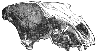
Fig. 84.—Skull of Hyena spelæa, × 14.
The Elephant is represented in the Preglacial and Glacial epochs by several species, some of which ranged as far north as Siberia. The African elephant is not now found north of the Pyrenees and the Alps. But a species of dwarf elephant, but four or five feet in height, has already been referred to as having occupied Malta and Sicily; and still another species has been found in Malta, whose average height was less than three feet. An extinct species (Elephas antiquus), whose remains are found in the river-drift and in the lower strata of sediment in many caverns as far north as Yorkshire, England, was of unusual size, and during the Glacial period was found on both sides of the Mediterranean. But the species most frequently met with in palæolithic times was the mammoth (Elephas primigenius). This animal, now extinct, accompanied man in nearly every portion both of Europe and North America, and lingered far down into post-glacial times before becoming extinct. This animal was nearly twice the weight of the modern elephant, and one third taller. Occasionally his tusks were more than twelve feet long, and curved upward in a circle. It is the carcasses of this animal which have been found in the frozen soil of Siberia and Alaska. It had a thick covering of long, black hair, with a dense matting of reddish wool at the roots. During the Glacial period these animals must have roamed in vast herds over the plains of northern France and southern England, and the northern half of North America.
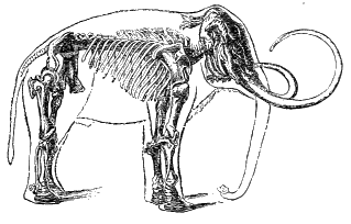
Fig. 85.—Celebrated skeleton of mammoth, in St. Petersburg museum.
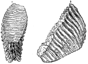
Fig. 86.—Molar tooth of mammoth (Elephas primigenius): a, grinding surface; b, side view.
The Hippopotamus is at present a familiar animal in the larger rivers of Africa, but is not now found in Europe. During the Glacial period, however, he ranged as far north as Yorkshire, England, and his remains were found in close association with those of man, both in Europe and on the Pacific coast in America. Twenty tons of their bones have been taken from a single cave in Sicily.[DJ]
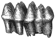
Fig. 87.—Tooth of Mastodon Americanus.
The mammoth and the rhinoceros we know to have been adapted to cold climates by the possession of long hair and thick fur, but the hippopotamus by its love for water would seem to be precluded from the possession of this protective covering. It is suggested, however, by Sir William Dawson, that he may have been adapted to arctic climates by a fatty covering, as the walrus is at the present time. A difficulty in accounting for many of the remains of the hippopotamus in some of the English caverns is that they are so far away from present or possible water-courses. But it would seem that due credit has not been ordinarily given to the migratory instincts of the animal. In southern Africa they are known to “travel speedily for miles over land from one pool of a dried-up river to another; but it is by water that their powers of locomotion are surpassingly great, not only in rivers, but in the sea.... The geologist, therefore, may freely speculate on the time when herds of hippopotami issued from North African rivers, such as the Nile, and swam northward in summer along the coasts of the Mediterranean, or even occasionally visited islands near the shore. Here and there they may have landed to graze or browse, tarrying awhile, and afterwards continuing their course northward. Others may have swum in a few summer days from rivers in the south of Spain or France to the Somme, Thames, or Severn, making timely retreat to the south before the snow and ice set in.” [DK]
The Mastodon (Mastodon Americanus), (Fig. 88), “is probably the largest land mammal known, unless we except the Dinotherium. It was twelve to thirteen feet high, and, including the tusks, twenty-four to twenty-five feet long. It differed from the elephant chiefly in the character of its teeth. The difference is seen in Figs. 86 and 87. The elephant’s tooth given above (Fig. 86) is sixteen inches long, and the grinding surface eight inches by four.”
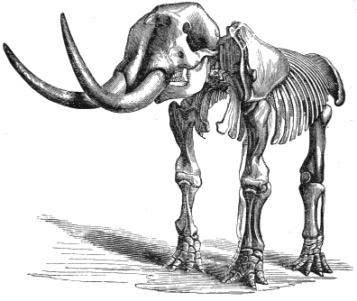
Fig. 88.—Mastodon Americanus (after Owen).
The mastodon, together with the mammoth, made their appearance about the middle of the Miocene epoch. At the close of the Tertiary period the mastodon became extinct on the Eastern Continent, but continued in North America to be a companion of man well on toward the close of the Glacial period. Many perfect skeletons have been found in the deposits of this period in North America. “One magnificent specimen was found in a marsh near Newburg, New York, with its legs bent under the body, and the head thrown up, evidently in the very position in which it mired. The teeth were still filled with the half-chewed remnants of its food, which consisted of twigs of spruce, fir, and other trees; and within the ribs, in the place where the stomach had been, a large quantity of similar material was found.”[DL]
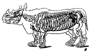
Fig. 89.—Skeleton of Rhinoceros tichorhinus.
The Rhinoceros is now confined to Africa and southern Asia; but the remains of four species have been found in America, Europe, and northern Asia, in deposits of the Glacial period. In company with that of the mammoth, already spoken of, a carcass of the woolly rhinoceros was found in 1771 in the frozen soil of northern Siberia. The bones of other species have been found as far north as Yorkshire, England. In the valley of the Somme there was found “the whole hind limb of a rhinoceros, the bones of which were still in their true relative position. They must have been joined together by ligaments and even surrounded by muscles at the time of their interment.” An entire skeleton was found near by. The gravel terrace in which these occurred is about forty feet above the floor of the valley, and must have been formed subsequent to some of the strata which contained the remains of human art. In America the bones are found in the gold-bearing gravels of California, in connection with human remains.
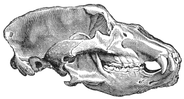
Fig. 90.—Skull of cave-bear (Ursus spelæus),
The Bear was represented in Europe in palæolithic times by three species, of which only one exists there at the present time. But during the Glacial period the grizzly bear, now confined to the western part of America, and the extinct cave-bear were companions, or enemies as the case may be, of man throughout Europe. The cave-bear was of large size, and his bones occur almost everywhere in the lower strata of sediment in the caves of England.
The Great Irish Elk, or deer, is now extinct, though it is supposed by some to have lingered until historic times. Its remains are found widely distributed over middle Europe in deposits of palæolithic age.
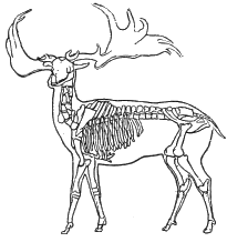
Fig. 91.—Skeleton of the Irish elk (Cervus megaceros).
The Horse was also, as we have seen, a very constant associate of man in middle Europe during the Palæolithic age, but probably not as a domesticated animal. The evidence is pretty conclusive that he was prized chiefly for food. About some of the caves in France such immense quantities of their bones are found that they can be accounted for best as refuse-heaps into which the useless bones had been thrown after their feasts, after the manner of the disposal of shells of shell-fish. In America the horses associated with man were probably of a species now extinct. The skull of one (Equus excelsus) recently found in Texas, in Pleistocene deposits, associated with human implements, is, according to Cope, intermediate in character between the horse and quagga.[DM] The frontal bone was crushed in in a manner to suggest that it had been knocked in the head with a stone hammer, such as was found in the same bed. Possibly, therefore, man’s love of horse-flesh may have been an important element in securing the extinction of the species in America.
Besides these animals there were associated with man at this time the Musk Sheep and the Reindeer, both now confined to the regions of the far north, but during the Glacial period ranging into southern France, and mingling their bones with those both of man and of the southern species already enumerated.
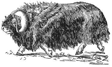
Fig. 92.—Musk-sheep (Ovibos moschatius).
The Wolverine, the Arctic Fox, the Marmot, the Lemming—all now confined to colder regions—at that time mingled on the plains of central Europe with the species mentioned as belonging now to Africa and southern Asia. The Ibex, also, and the Snowy Vole and Chamois descended to the plains from their mountain-heights, and joined in the strange companionship of animals from the north and from the south.
Besides these extremes there were associated with man during the Glacial period numerous representatives of the temperate group of existing animals, such as the bison, the horse, the stag, the beaver, the hare, the rabbit, the otter, the weasel, the wild-cat, the fox, the wolf, the wild boar, and the brown bear.
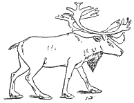
Fig. 93.—Reindeer.
To account for this strange intermingling of arctic and torrid species of animals, especially in Europe, during man’s occupancy of the region in glacial times, various theories have been resorted to, but none of them can be said to be altogether satisfactory. One hypothesis is that the bones of these diverse animals became mingled by reason of the great range of the annual migration of the species. The reindeer, for example, still performs extensive annual migrations. In summer it ventures far out upon the tundras of North America and Siberia to feed upon the abundant vegetation that springs up like magic under the influence of the long days of sunshine; while, as winter approaches, it returns to the forests of the interior. Or in other places this animal and his associates, like birds of passage, move northward in summer to escape the heat, and southward in the winter to escape the extreme cold. Many of the other animals also are more or less migratory in their habits.
Thus it is thought that during the Glacial period, when man occupied northern France and southern England, the reindeer, the musk sheep, the arctic fox, and perhaps the hippopotamus and some other animals, annually vibrated between northern England and southern France, a slight elevation of the region furnishing a land passage from England to the continent; while the chamois and other Alpine species vibrated as regularly between the valleys in winter and the mountain-heights in summer. The habits of these species are such that it is not difficult to see how in their case this migration could have taken place.
Professor Boyd Dawkins attempts to reduce the difficulty by supposing that the Glacial epoch was marked by the occurrence of minor periods of climatic variation, during which, in comparatively short periods, the isothermal lines vibrated from north to south, and vice versa. In this view the southern species gradually crowded upon the northern during the periods of climatic amelioration, until they reached their limit in central England, and then in turn, as the climate became more rigorous, slowly retreated before the pressure of their northern competitors. Meanwhile the hyena sallied forth from his various caves, over this region, at one time of the year to feed upon the reindeer, and at another time of the year upon the flesh of the hippopotamus, in both cases dragging their bones with him to his sheltered retreat in the limestone caverns[DN] which he shared at intervals with palæolithic man.
The theory of Mr. James Geikie is that the period, while one of great precipitation, was characterised by a climate of comparatively even temperature, in which there was not so great a difference as now between the winters and the summers, the winters not being so cold and the summers not so hot as at present. This is substantially the condition of things in southern Alaska at the present time, where extensive glaciers come down to the sea-level, even though the thermometer at Sitka rarely goes below zero (Fahrenheit). It is, therefore, easy to conceive that if there were extensive plains bordering the Alaskan archipelago, so as to furnish ranging grounds for more southern species, the animals of the north and the animals of the south might partially occupy the same belt of territory, and their bones become mingled in the same river deposits.
In order to clear the way for either of these hypotheses to account for the mingling of arctic and torrid species characteristic of the period under consideration in Europe, we must probably suppose such an elevation of the region to the south as to afford land connection between Europe and Africa. This would be furnished by only a moderate amount of elevation across the Strait of Gibraltar and from the south of Italy to the opposite shore in Africa; and there are many indications, in the distribution of species, of the existence in late geological times of such connection.
It should also be observed that the present capacities and habits of species are not a certain criterion of their past habits and capacities. As already remarked, both the rhinoceros and the mammoth of glacial times were probably furnished with a woolly protection, which enabled them to endure more cold than their present descendants could do, while the elephant is even now known to be able to endure the rigors of the climate at great elevations upon the Himalaya Mountains. We can easily imagine these species to have been adjusted to quite different climatic conditions from those which now seem necessary to their existence. In the case of the hippopotamus, also, it is quite possible, as already suggested, that it is more inclined to migration than is generally supposed.
Geikie’s theory of the prevalence of an equable climate during a portion of the Glacial period in Europe is thought to be further sustained by the character of the vegetation which then covered the region, as well as by the remains of the mollusks which occupied the waters. Then “temperate and southern species like the ash, the poplar, the sycamore, the fig-tree, the Judas-tree, the laurel, etc., overspread all the low ground of France, as far north at least as Paris.... It was under such conditions,” continues Geikie, "that the elephants, rhinoceroses, and hippopotamuses, and the vast herds of temperate cervine and bovine species ranged over Europe, from the shores of the Mediterranean up to the latitude of Yorkshire, and probably even farther north still; and from the borders of Asia to the Western Ocean. Despite the presence of numerous fierce carnivora—lions, hyenas, tigers, and others—Europe at that time, with its shady forests, its laurel-margined streams, its broad and deep-flowing rivers, a country in every way suited to the needs of a race of hunters and fishers—must have been no unpleasant habitation for palæolithic man.
“This, however, is only one side of the picture. There was a time when the climate of Pleistocene Europe presented the strongest contrast to those genial conditions—a time when the dwarf birch of the Scottish Highlands, and the arctic willow, with their northern congeners, grew upon the low grounds of middle Europe. Arctic animals, such as the musk sheep and the reindeer, lived then, all the year round, in the south of France; the mammoth ranged into Spain and Italy; the glutton descended to the shores of the Mediterranean; the marmot came down to the low grounds at the foot of the Apennines; and the lagomys inhabited the low-lying maritime districts of Corsica and Sardinia. The land and fresh-water shells of many Pleistocene deposits tell a similar tale; boreal, high alpine, and hyperborean forms are characteristic of these accumulations in central Europe; even in the southern regions of our continent the shells testify to a former colder and wetter climate.”[DO]
In Mr. Geikie’s view these facts indicate two Glacial periods, with an intervening epoch of mild climate. In the opinion of others they are readily explainable by the coming on and departure of a single Ice age, with its various minor episodes.
Earliest Remains of Man on the Pacific Coast of North America.
Most interesting evidence concerning the antiquity of man in America, and his relation to the Glacial period, has come from the Pacific coast. During the height of the mining activity in California, from 1850 to 1860, numerous reports were rife that human remains had been discovered in the gold-bearing gravel upon the flanks of the Sierra Nevada Mountains. These reports did not attract much scientific attention until they came to relate to the gravel deposits found deeply buried beneath a flow of lava locally known as the Sonora or Tuolumne Table Mountain. This lava issued from a vent near the summit of the mountain-range, and flowed down the valley of the Stanislaus River for a distance of fifty or sixty miles, burying everything in the valley beneath it, and compelling the river to seek another channel. The thickness of the lava averages about one hundred feet, and so long a time has elapsed since the eruption that the softer strata on either side of the valley down which it flowed have been worn away to such an extent that the lava now rises nearly everywhere above the general level, and has become a striking feature in the landscape, stretching for many miles as a flat-topped ridge about half a mile in width, and presenting upon the sides a perpendicular face of solid basalt for a considerable distance near the lower end of the flow.
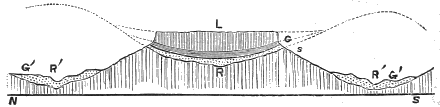
Fig. 94.—Section across Table Mountain, Tuolumne County, California: L, lava; G, gravel; S, slate; R, old river-bed; R′, present river-bed.
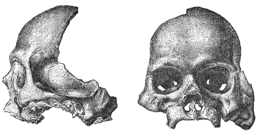
Fig. 95.—Calaveras Skull. (From Whitney.)
It was under this mountain of lava that the numerous implements and remains of man occurred which were reported to Professor J. D. Whitney when he was conducting the geological survey of California between 1860 and 1870. The implements consisted of stone mortars and pestles, suitable for use in grinding acorns and other coarse articles of food. There were, however, some rude articles of ornament. In one of the mining shafts penetrating the gravel underneath Table Mountain, near Sonora, there was reported to have been discovered, in 1857, a human jawbone, one portion of which was sent by responsible parties to the Boston Society of Natural History, and another part to the Philadelphia Academy of Sciences, in whose collections the fragments can now be seen.
Interest reached a still higher pitch when, in 1860, an entire human skull with some other human bones was reported to have been discovered under this same lava deposit, a few miles from Sonora, at Altaville, in Calaveras County, and hence known as the “Calaveras skull.” Persistent efforts were made soon after to discredit the genuineness of this discovery. Bret Harte showered upon it the shafts of his ridicule, and various other persons gave currency to the story that the whole report originated in a joke played by the miners upon unsuspecting geologists. These attacks were so successful that many conservative archæologists and men of science have refused to accept the skull as genuine.
Recent events, however, have brought such additional evidence[DP] to the support of this discovery that it would seem unreasonable any longer to refuse to credit the testimony. At the meeting of the Geological Society of America, at Washington, in January, 1891, Mr. George P. Becker, of the United States Geological Survey, who for some years has had charge of investigations relating to the gold-bearing gravels of the Pacific coast, presented the affidavit of Mr. J. H. Neale, a well-known mining engineer of unquestionable character, stating that he had taken a stone mortar and pestle, together with some spear-heads (which through Mr. Becker he presented to the Society), from undisturbed strata of gravel underneath the lava of Table Mountain, near Rawhide Gulch, a few miles from Sonora. At the same meeting Mr. Becker presented a pestle which Mr. Clarence King, the first director of the United States Geological Survey, took with his own hands out of undisturbed gravel under this same lava deposit, near Tuttletown, a mile or two from the preceding locality mentioned.
I was so fortunate, also, as to be able to report to the Society at the same meeting the discovery, in 1887, of a small stone mortar by Mr. C. McTarnahan, the assistant surveyor of Tuolumne County. This mortar was found by Mr. McTarnahan in the Empire mine, which penetrates the gravel underneath Table Mountain, about three miles from Sonora, and not far from the other localities above mentioned. The place where the mortar was found is about one hundred and seventy-five feet in from the edge of the superincumbent lava, which is here about one hundred feet in thickness. At my request, this mortar was presented by its owner, Mrs. M. J. Darwin, to the Western Reserve Historical Society of Cleveland, Ohio, in whose collection it can now be seen.
These three independent instances, each of them authenticated by the best of evidence, have such cumulative force that probably few men of science will longer stand out against it.
Associated with these discoveries, there is to be mentioned another, which was brought to my notice by Mr. Charles Francis Adams in October, 1889.[DQ] This was a miniature clay image of a female form, about one inch and a half in length, and beautifully formed, which was found, in August, 1889, by Mr. M. A. Kurtz, while boring an artesian well at Nampa, Ada County, Idaho. The strata passed through included, near the surface, fifteen feet of lava. Underneath this, alternating beds of clay and quicksand occurred to a depth of three hundred and twenty feet, where there appeared indications of a former surface soil lying just above the bed-rock, from which the clay image was brought up in the sand-pump.
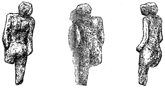
Fig. 96.—Three views of Nampa image drawn to scale. The middle one is from a photograph.
I devoted the summer of 1890 to a careful study of the lava deposits both in Idaho and in California, with a view to learning their significance with reference to these discoveries. The main facts brought to light by this investigation are that in the Snake River Valley, Idaho, there are not far from twelve thousand square miles of territory covered with a continuous stratum of basaltic lava, extending nearly across the entire diameter of the State from east to west. Nampa, where the miniature image was discovered, is within five miles of the western limit of this lava-flow, and where it had greatly thinned out. The relative age of the lava is shown by its relation to Tertiary beds of shale and sandstone, containing numerous fossils of late Pliocene species. These are overlaid in this vicinity by the lava, thus determining its post-Tertiary character. Examination with reference to the more precise determination of age reveals channels of erosion formed since the lava-flow took place, which, when studied sufficiently, will probably lead to valuable approximate results. At present I can only say that the amount of erosion since the lava eruptions of western Idaho is not excessive, and very likely may be brought within a period of from ten thousand to twenty thousand years. The enormous erosion in the cañon of the Snake River, near Shoshone Falls, in central Idaho, is doubtless of a much earlier date than that in the Boise River, near Nampa.
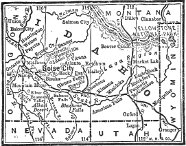
Fig. 97.—Map showing Pocatello, Nampa, and the valley of Snake River.
The disturbances created in this part of the valley by the bursting of the barriers between the glacial Lake Bonneville and the Snake River, already described (see above, page 233), have not been worked out. There can be no doubt, however, that interesting results will come to light in connection with the problem; for Pocatello, the point at which the débâcle reached the Snake River plain, is about 2,000 feet higher than Nampa, and 350 miles distant, and the water must have poured into the valley faster than the river in its upper portion could have discharged it. By just what channels the mighty current worked down to the lower levels on the western borders of the State it would be most interesting as well as instructive to know.
A study of the situation in Tuolumne and Calaveras Counties, California, reveals a state of things closely resembling, in important respects, that in western Idaho. At first sight the impression is made that an immense lapse of time must have occurred since the volcanic eruption which furnished the lava of Table Mountain. The Stanislaus River flows in a channel of erosion a thousand feet or more lower than the ancient channel filled by lava, and in two or three places cuts directly across it. An immense amount of time, also, would seem to be required to permit the smaller local streams to have worn away so much of the sides of the ancient valley as to allow the lava deposit now so continuously to rise above the general surface. Still, the question of absolute time cannot be considered separately without much further study. It is by no means certain that, when the lava-stream poured down the mountain, it always followed the lowest depressions; but at certain points it may have been dammed up in its course by its own accumulations so as to be turned off into what was then an ancient abandoned channel.
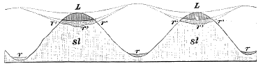
Fig. 98.—Section along the line, north and south: r′ r′, old river-beds; r r, present river-beds; L, lava; sl, slate.
The forms of animal and vegetable life with which the remains of man under Table Mountain are associated, are, indeed, to a considerable extent, species now extinct in California, and some of them no longer exist anywhere in the world. But a suggestion of Professor Prestwich, in England, made with reference to the extinct forms of life associated with human remains in the glacial deposits in Europe, is revived by Mr. Becker, of the Geological Survey, with reference to the California discoveries; his inference being, not that man is so extremely ancient in California, but that many of these plants and animals have continued to a more recent date than has ordinarily been supposed.
The connection of these lava-flows on the Pacific coast with the Glacial period is unquestionably close. For some reason which we do not fully understand, the vast accumulation of ice in North America during the Glacial period is correlated with enormous eruptions of lava west of the Rocky Mountains, and, in connection with these events, there took place on the Pacific coast an almost entire change in the plants and animals occupying the region. Mr. Warren Upham is of the opinion that on the Pacific coast they lingered much later than in the region east of the Rocky Mountains. Indeed, it is pretty certain that not many centuries have elapsed since the glacial phenomena of the Sierra Nevada Mountains were much more pronounced than they are at the present time, and it is equally certain that there have been vast eruptions of lava in California within three hundred years.
From these data, therefore, Mr. Becker has real foundation for his suggestion that perhaps in the Glacial period California was a kind of health resort for Pliocene animals, as it is at the present time for man; or, at any rate, that the later date of the accumulations permitted the animals to survive there much longer than in the region east of the Rocky Mountains.
Further discussion of the preceding facts will profitably be deferred until, in the next two chapters, the questions of the cause and date of the Glacial period have been considered.
CHAPTER IX.
THE CAUSE OF THE GLACIAL PERIOD.
In searching for the cause of the Glacial period, it is evident that we must endeavor to find conditions which will secure over the centre of the glaciated area either a great increase of snow-fall or a great decrease in the mean annual temperature, or both of these conditions combined in greater or less degree. As can be seen, both from the nature of the case and from the unglaciated condition of Siberia and northern Alaska, a low degree of temperature is not sufficient to produce permanent ice-fields. If the snow-fall is excessively meagre, even the small amount of heat in an arctic summer will be sufficient to melt it all away.
From the condition of Greenland, however, it appears that a moderate amount of precipitation where it is chiefly in the form of snow may produce enormous glaciers if at the same time the average temperature is low. In southeastern Alaska, on the other hand, the glaciers are of enormous size, though the mean annual temperature is by no means low, for there the great amount of snow-fall amply compensates for the higher temperature.
Snow stores the cold and keeps it in a definite place. If the air becomes chilled, circulation at once sets in, and the cold air is transferred to warmer regions; but if there is moisture in the air, so that snow forms, the cold becomes locked up, as it were, and falls to the earth.
The amount of cold thus locked up in snow is enormous. To melt one cubic foot of ice requires as much heat as would raise the temperature of a cubic foot of water 176° Fahrenheit. To melt a “layer of ice only one inch and a half thick would require as much heat as would raise a stratum of air eight hundred feet thick from the freezing-point to the tropical heat of 88° Fahrenheit.” It is the slowness with which ice melts which enables it to accumulate as it does, both in winter and upon high mountains and in arctic regions. Captain Scoresby relates that when near the north pole the sun would sometimes be so hot as to melt the pitch on the south side of his vessel, while water was freezing on the north side, in the shade, owing to the cooling effect of the masses of ice with which he was surrounded.
Thus it will appear that a change in the direction of the moist winds blowing from the equator towards the poles might produce a Glacial epoch. If snow falls upon the ocean it cools the water, but through the currents, everywhere visible in the sea, the temperature in the water in the different parts soon becomes equalized. If, however, the snow falls upon the land, it must be melted by the direct action of the sun and wind upon the spot where it is. If the heat furnished by these agencies is not sufficient to do it year by year, there will soon be such an accumulation that glaciers will begin to form. It is clear, therefore, that the conditions producing a Glacial period are likely to prove very complicated, and we need not be surprised if the conclusions to which we come are incapable of demonstration.
Theories respecting the cause of the Glacial period may be roughly classified as astronomical and geological. Among the astronomical theories, one which has sometimes been adduced is that the solar system in its movement through space is subjected to different degrees of heat at different times. According to this theory, the temperate climate which characterised the polar regions during the Tertiary period, and continued up to the beginning of the Glacial epoch, was produced by the influence of the warmer stretches of space through which the whole solar system was moving at that time; while the Glacial period resulted from the influence upon the earth of the colder spaces through which the system subsequently moved.
While it is impossible absolutely to disprove this hypothesis, it labors under the difficulty of having little positive evidence in its favor, and thus contravenes a fundamental law of scientific reasoning, that we must have a real cause upon which to rest our theories. In endeavouring to explain the unknown, we should have something known to start with. But in this case we are not sure that there are any such variations in the temperature of the space through which the solar system moves. This theory, therefore, cannot come in for serious consideration until all others have been absolutely disproved. As we shall also more fully see, in the subsequent discussion, the distribution of the ice during the Glacial period was not such as to indicate a gradual extension of it from the north pole, but rather the accumulation upon centres many degrees to the south.
Closely allied with the preceding theory is the supposition broached by some astronomers that the sun is a variable star, dependent to some extent for its heat upon the impact of meteorites, or to the varying rapidity with which the contraction of its volume is proceeding.
It is well known that when two solid bodies clash together, heat is produced proportionate to the momentum of the two bodies. In other words, the motion which is arrested is transformed into heat. Mr. Croll, in his last publication[DR] upon the subject, ingeniously attempted to account for the gaseous condition of the nebulæ and the heat of the sun and other fixed stars by supposing it to be simply transformed motion. According to this theory, the original form of force imparted to the universe was that exerted in setting in motion innumerable dark bodies, which from time to time have collided with each other. The effects of such collisions would be to transform a large amount of motion into heat and its accompanying forms of molecular force. The violence of the compact of two worlds would be so great as to break them up into the original atoms of which they are composed, and the heat set free would be sufficient to keep the masses in a gaseous condition and cause them to swell out into enormous proportions. From that time on, as the heat radiated into space, there would be the gradual contraction which we suppose is going on in all the central suns, accompanied, of course, with a gradual decline of the heat-energy in the system.
Now, it is well known that the earth and the solar system in their onward progress pass through trains of meteorites. The tails of some of the comets are indeed pretty clearly proved to be streams of ponderable matter, through which, from time to time, the minor members of the solar system plunge, and receive some accession to their bulk and weight. The shooting-stars, which occasionally attract our attention in the sky, mark the course of such meteorites as they pass through the earth’s atmosphere, and are heated to a glow by the friction with it. It has been suggested, therefore, that the sun itself may at times have its amount of heat sensibly affected by such showers of meteorites or asteroids. Upon this theory the warm period of the Tertiary epoch, for instance, may have been due to the heat temporarily added to the sun by impact with minor astronomical bodies. When, afterwards, it gradually cooled down, receiving through a long period no more accessions of heat from that source, the way was prepared for the colder epoch of the Glacial period, which, in turn, was dispelled by fresh showers of meteorites upon the sun, sufficient to produce the amelioration of climate which we experience at the present time.
As intimated, this theory is closely allied to the preceding, the principal difference being that it limits the effects of the supposed cause to the solar system, and looks to our sun as the varying source of heat-supply. It has the advantage over that, however, of possessing a more tangible vera causa. Meteorites, asteroids, and comets are known to be within this system, and have occasional collisions with other members of it. But the principal objection urged against the preceding theory applies here, also, with equal force. The accumulations of ice during the Glacial period were not determined by latitude. In North America the centre of accumulation was south of the Arctic Circle—a fact which points clearly enough to some other cause than that of a general lowering of the temperature exterior to the earth.
The same objections would bear against the theory ably set forth by Mr. Sereno E. Bishop, of Honolulu, which, in substance, is that there may be considerable variability in the sun’s emission of heat, owing to fluctuations in the rate of the shrinkage of its diameter, brought about by the unequal struggle between the diminishing amount of heat in the interior and the increasing force of the gravitation of its particles, and by the changes in the enveloping atmosphere of the sun, which, like an enswathing blanket, arrests a large portion of the radiant heat from the nucleus, and is itself evidently subject to violent movements, some of which seem to carry it down to the sun’s interior. Unknown electrical forces, he thinks, may also combine to add an element of variability. These supposed changes may be compared to those which take place upon the surface of the earth when, at irregular intervals, immense sheets of lava, like those upon the Pacific coast of North America, are exuded in a comparatively brief time, to be succeeded by a long period of rest. The heat thus brought to the surface of the earth would add perceptibly to that radiated from it into space in ordinary times. Something similar to this upon the sun, it is thought, might produce effects perceptible upon the earth, and account for alternate periods of heat and cold.
A fourth astronomical theory is that there has been a shifting of the earth’s axis; that at the time of the Glacial period the north pole, instead of being where it now is, was somewhere in the region of central Greenland. This attractive theory has been thought worthy of attention by President T. C. Chamberlin and by Professor G. C. Comstock,[DS] but it likewise labours under a twofold difficulty: First, the shifting of the poles observed (450 feet per year) is too slight to have produced the changes within any reasonable time, and it is not likely to have been continuous for a long period. But still more fatal to the theory is the fact that the warm climate preceding the Glacial period seems to have extended towards the present north pole upon every side; a temperate flora having been found in the fossil plants of the Tertiary beds in Greenland and northern British America, as well as upon Nova Zembla and Spitzbergen.
A fifth astronomical theory, and one which has of late years been received with great favour, is that so ably advocated by the late Dr. James Croll and by Professor James Geikie. Following the suggestions of the astronomer Adhémar, these writers have attempted to show that not only one Glacial epoch, but a succession of such epochs, has been produced in the world by the effect of the changes which are known to have taken place in the eccentricity of the earth’s orbit when combined with the precession of the equinoxes—another calculable astronomical cause.
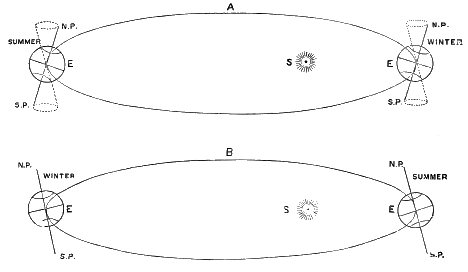
Fig. 99.—Diagram showing effect of precession: A. condition of things now; B. as it will be 10,500 years hence. The eccentricity is of course greatly exaggerated.
It is well known that the earth’s orbit is elliptical; that is, it is longer in one direction than in the other, so that the sun is one side of the centre. During the winter of the northern hemisphere the earth is now about three million miles nearer the sun than in the summer; but the summer makes up for this distance by being about seven days longer than the winter. Through the precession of the equinoxes this state of things will be reversed in ten thousand five hundred years; at which time we shall be nearer the sun during our northern summer, and farther away in winter, our winter then being also longer than our summer. Besides, through the unequal attraction of the planets the eccentricity of the earth’s orbit periodically increases and diminishes, so that there have been periods when the earth was ten million five hundred thousand miles farther from the sun in winter than in summer; at which times, also, the winter was nearly twenty-eight days longer than the summer. Such an extreme elongation of the earth’s orbit occurred about two hundred and fifty thousand years ago.
It is easy to assume that such a change in astronomical conditions would produce great effects upon the earth’s climate; and equally easy to connect with those effects the vast extension of ice during the Glacial period. Since, also, this period of extreme eccentricity terminated only eighty thousand years ago, the close of the Glacial period would, perhaps, upon Mr. Croll’s theory, be comparatively a recent event; for if the secular summer of the earth’s eccentricity lags relatively as far behind the secular movements as the annual summer does behind the vernal equinox, we should, as Professor Charles H. Hitchcock suggests, have to place the complete breaking up of the Ice period as late as forty thousand years ago.[DT]
We have no space to indicate, as it deserves, the comparative merits and demerits of this ingenious theory. It would, however, be a great calamity to have geologists accept it without scrutiny. It is, indeed, a part of the business of geologists to doubt such theories until they are verified by a thorough examination of all accessible terrestrial evidence bearing upon the subject. There is no reason to question the reality of the variations in the relative positions of the earth and the sun assumed by Mr. Croll; though there may be serious doubt whether the effects of those changes upon climate would be all that is surmised, since equal amounts of heat would fall upon the earth during summer, whether made longer or shorter by the cause referred to. During the short summers the earth is so much nearer the sun that it receives each season absolutely as much heat as it does during the longer summers, when it is so much farther away from the sun. Thus the theory rests at last upon the question what would become of the heat reaching the earth in these differing conditions. It is plausibly urged by Mr. Croll that when a hemisphere of the earth is passing through a period of long winters the radiation of heat will be so excessive that the temperature would fall much below what it would during the shorter winters; and so ice and snow would accumulate far beyond the usual amount. It is also supposed that the effect of the summer’s sun in melting the ice during the short summer would be diminished through natural increase of the amount of foggy and cloudy weather.
Adhémar’s theory is supposed by Sir Robert Ball, Royal Astronomer of Ireland, to be considerably re-enforced by a discovery which he has made concerning the distribution of heat upon the earth during the seasons culminating in the summer and winter solstices. Croll had assumed, on the authority of Herschel, that a hemisphere of the earth during the longer winter in aphelion would receive the same actual amount of heat which would fall upon it during the shorter summer in perihelion; whereas, according to Dr. Ball’s discovery, “of the total amount of heat received from the sun on a hemisphere of the earth in the course of a year, sixty-three per cent is received during the summer and thirty-seven per cent during the winter.”[DU] When, therefore, the summers occur in perihelion the heat is more intense than Croll had supposed, and, at the same time, the winters occurring in aphelion are more deficient in heat than he had assumed. This discovery of Dr. Ball will not, however, materially affect the discussion of Croll’s theory upon its inherent merits, since it is simply an intensification of the causes invoked by him. We will therefore let it stand or fall in the light of the general considerations hereafter to be adduced.
The aid of theoretical consequent changes in the volume of the Gulf Stream, and in the area of the trade-winds, has also to be invoked by Mr. Croll. The theory likewise receives supposed confirmation from facts alleged concerning the present climate of the southern hemisphere which is passing through the astronomical conditions thought to be favourable to its glaciation. The antarctic continent is completely enveloped in ice, even down to the sixty-seventh degree of latitude. A few degrees nearer the pole Sir J. C. Boss describes the ice as rising from the water in a precipitous wall one hundred and eighty feet high. In front of such a wall, and nearly twenty degrees from the south pole, this navigator sailed four hundred and fifty miles! Voyagers, in general, are said to agree that the summers of the antarctic zone are much more foggy and cold than they are in corresponding latitudes in the northern hemisphere; and this, even though the sun is 3,000,000 miles nearer the earth during the southern summer than it is during the northern.
Another direction from which evidence is invoked in confirmation of Mr. Croll’s theory is the geological indications of successive Glacial epochs in times past. If there be a recurring astronomical cause sufficient of itself to produce Glacial periods, such periods should recur as often as the cause exists; but glaciation upon the scale of that which immediately preceded the historic era could hardly have occurred in early geological time without leaving marks which geologists would have discovered. Were the “till” now covering the glaciated region to be converted into rock, its character would be unmistakable, and the deposit is so extensive that it could not escape notice.
In his inaugural address before the British Association in 1880, Professor Ramsey, Director-General of the Geological Survey of Great Britain, presented a formidable list of glacial observations in connection with rocks of a remote age.[DV] Beginning at the earliest date, he cites Professor Archibald Geikie, one of the most competent judges, as confident that the rounded knobs and knolls of Laurentian rocks exposed over a large region in northwestern Scotland, together with vast beds of coarse, angular, unstratified conglomerates, are unquestionable evidences of glacial action at that early period. Masses of similar conglomerates, resembling consolidated glacial boulder-beds, occur also in the Lower Silurian formation at Corswall, England. In Dunbar, Scotland, Professor Forbes also found, in formations of but little later age than the Coal period, “brecciated conglomerates, consisting of pebbles and large blocks of stone, generally angular, embedded in a marly paste, in which some of the pebbles are as well scratched as those found in medial moraines.” In formations of corresponding antiquity the geologists of India have found similar boulder-beds, in which some of the blocks are polished and striated.
Still, this evidence is less abundant than we should expect, if there had been the repeated Glacial epochs supposed by Mr. Croll’s astronomical theory; and it is by no means impossible that the conglomerates of scratched stones described by Professor Ramsey in Great Britain, and by Messrs. Blandford and Medlicott in India, may have resulted from local glaciers coming down from mountain-chains which have been since removed by erosion or subsidence. We are not aware that any incontestable evidence has been presented in America of any glaciation previous to that of the Glacial period.
Upon close consideration, also, it appears that Mr. Croll’s theory has not properly taken into account the anomalous distribution of heat which we actually find to take place on the surface of the earth. He has done good service in showing what an enormous transfer of heat there is from the southern to the northern Atlantic by means of the Gulf Stream, estimating that the heat conveyed by the Gulf Stream into the Atlantic Ocean is equal to one fifth of all possessed by the waters of the North Atlantic; or to the heat received from the sun upon a million and a half square miles at the equator, or two million square miles in the temperate zone. “The stoppage of the Gulf Stream would deprive the Atlantic of 77,479,650,000,000,000,000 foot-pounds of energy in the form of heat per day.”
Among the objections which bear against this ingenious theory is one which will appear with great force when we come to discuss the date of the Glacial period, when we shall show that even Professor Hitchcock’s supposition that the lingering effects of the last great eccentricity of the earth’s orbit, continued down to forty thousand years ago, is not sufficient to account for the recentness of the close of the period as shown by abundant geological evidence. It is certainly not more than ten or fifteen thousand years ago that the ice finally melted off from the Laurentian highlands; while on the Pacific coast the period of glaciation was still more recent.
From inspection of the accompanying map the main point of Mr. Croll’s reasoning may be understood. It will be seen that the direction of the currents in the central Atlantic is largely determined by the contour of the northeastern coast of South America. From some cause the southeast trade-winds are stronger than the northeast, and their force is felt in pushing the superficial currents of warm water farther north than Cape St. Roque, the eastern extremity of Brazil. As the direction of the South American coast trends rapidly westward from this point to the Isthmus of Panama, the resultant of the forces is a strong current northwestward into the cul-de-sac of the Gulf of Mexico, from which there is only the one outlet between Cuba and the peninsula of Florida. Through this the warm water is forced into the region where westerly winds prevail, and spreads its genial influence far to the northward, modifying the climate of the British Isles, and even of far-off Norway.
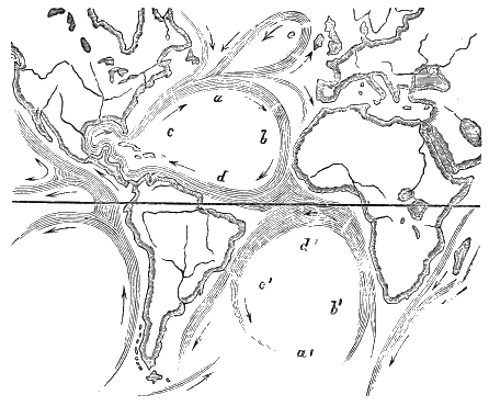
Fig. 100.—Map showing course of currents in the Atlantic Ocean: b and b′ are currents set in motion by opposite trade-winds; meeting, they produce the equatorial current, which divides into c and c′, continuing on as a and a′ and e.
But why are the southeast trade-winds of the Atlantic stronger than the northeast? The ultimate reason, of course, is to be found in the fact that the northern hemisphere is warmer than the southern. The atmosphere over the northern-central portion of the Atlantic region is more thoroughly rarefied by the sun’s heat than is that over the region south of the equator. The strong southeast trades are simply the rush of atmosphere from the South Atlantic to fill the vacuum caused by the heat of the sun north of the equator.
But, again, why is this? Because, says Mr. Croll, we are now in that stage of astronomical development favourable to the increased warmth of the northern hemisphere. In the northern hemisphere the summers are longer than the winters. Perihelion occurs in winter and aphelion in summer. This is the reason why the North Atlantic is warmer than the South Atlantic, and why the trade-winds of the south are drawn to the north of the equator. Ten thousand five hundred years ago, however, the conditions were reversed, and the greater rarefaction of the atmosphere would have taken place south of the equator, thus drawing the trade-winds in that direction.
By again inspecting the map, one will see how far-reaching the effect on the climate of northern countries this change in the prevalences of the trades would have been. Then, instead of having the northwest current leading along the northeast coast of South America into the Gulf of Mexico augmented by the warm currents circulating south of the equator, the warm currents of the north would have been pushed down so far that they would augment the current running to the southwest beyond Cape St. Roque, along the southeast shore of South America; thus the northern portion of the Atlantic, instead of robbing the southern portion of heat, would itself be robbed of its warm currents to contribute to the superfluous heat of the South Atlantic.
This theory is certainly very ingenious. There is a weak point in it, however. Mr. Croll assumes that when the winters of the northern hemisphere occur in aphelion, they must necessarily be colder than now. But, evidently, this assertion implies a fuller knowledge than we possess of the laws by which the heat received from the sun is distributed over the earth.
For it appears from observation that the equator is by no means so hot now as, theoretically, it ought to be, and that the arctic regions are not so cold as, according to theory, they should be, and this in places which could not be affected by oceanic currents. For example, at Iquitos, on the Amazon, only three hundred feet above tide, three degrees and a half south of the equator, and more than a thousand miles from the Atlantic (so that ocean-currents cannot abstract the heat from its vicinity), the mean yearly temperature is but 78° Fahr.; while at Verkhojansk, in northeast Siberia, which is 67° north of the equator, and is situated where it is out of the reach of ocean-currents, and where the conditions for the radiation of heat are most favourable, and where, indeed, the winter is the coldest on the globe (January averaging—56° Fahr.), the mean yearly temperature is two degrees and a half above zero; so that the difference between the temperature upon the equator and that at the coldest point on the sixty-seventh parallel is only about 75° Fahr.; whereas, if temperature were in proportion to heat received from the sun, the difference ought to be 172°. Again, the difference between the actual January temperature on the fiftieth parallel and that upon the sixtieth is but 20° Fahr., whereas, the quantity of solar heat received on the fiftieth parallel during the month of January is three times that received upon the sixtieth, and the difference in temperature ought to be about 170° Fahr. upon any known law in the case.
Woeikoff, a Russian meteorologist, and one of the ablest critics of Mr. Croll’s theory, and to whom we are indebted for these facts, ascribes the greater present warmth of the northern Atlantic basin, not to the astronomical cause invoked by Mr. Croll, but to the relatively small extent of sea in the middle latitudes of the northern hemisphere. The extent and depth of the oceans of the southern hemisphere would of themselves give greater steadiness and force to its trade-winds, and lead to a general lowering of the temperature; so that it is doubtful if the astronomical causes introduced by Mr. Croll, even with Dr. Ball’s re-enforcement, would produce any appreciable effect while the distribution of land and water remains substantially what it is at the present time.
Still another variation in the astronomical theory has been set forth and defended by Major-General A. W. Drayson, F. R. A. S., instructor in the Royal Military School at Woolwich, England. He contends that what has been called the precession of the equinoxes, and supposed to be “a conical movement of the earth’s axis in a circle around a point as a centre, from which it continually decreases its distance,”[DW] is really a second rotation of the earth about its centre. As a consequence of this second rotation, he endeavours to show that the inclination of the earth’s axis varies as much as 12°; so that, whereas the Arctic and Antarctic Circles and the tropics extend to only about 23° from the poles and the equator, respectively, about thirteen thousand five hundred years ago they extended more than 35°; thus bringing the frigid zones in both cases 12° nearer the equator than now. This, he contends, would have produced the Glacial period at the time now more generally assigned to it by direct geological evidence.
The difficulty with this theory, even if the mathematical calculations upon which it is based are correct, would be substantially the same as those already urged against that of Mr. Croll. It is specially difficult to see how General Drayson would account for the prolonged temperate climate in high northern latitudes during the larger part of the Tertiary epoch.
It will be best to turn again to the map to observe the possible effect upon the Gulf Stream of a geological event of which we have some definite evidence, and which is adduced by Mr. Upham and others as one of the important probable causes of the Glacial period, namely, the subsidence of the Isthmus of Panama and the adjacent narrow neck of land connecting North with South America. It will be seen at a glance that a subsidence sufficient to allow the northwest current of warm water, pushed by the trade-winds along the northeast shore of South America, to pass into the Pacific Ocean, instead of into the Gulf of Mexico, would be a cause sufficient to produce the most far-reaching results; it would rob the North Atlantic of the immense amount of heat and moisture now distributed over it by the Gulf Stream, and would add an equal amount to the northern Pacific Ocean, and modify to an unknown extent the distribution of heat and moisture over the lands of the northern hemisphere.
The supposition that a subsidence of the Isthmus of Panama was among the contributing causes of the Glacial period has been often made, but without any positive proof of such subsidence. From evidence which has recently come to light, however, it is certain that there has actually been considerable subsidence there in late Tertiary if not in post-Tertiary times. This evidence is furnished by Dr. G. A. Maack and Mr. William M. Gabb in their report to the United States Government in 1874 upon the explorations for a ship-canal across the isthmus, and consists of numerous fossils belonging to existing species which are found at an elevation of 150 feet above tide. As the dividing ridge is more than 700 feet above tide, this does not positively prove the point, but so much demonstrated subsidence makes it easy to believe, in the absence of contradictory evidence, that there was more, and that the isthmus was sufficiently submerged to permit a considerable portion of the warm equatorial current which now passes northward from the Caribbean Sea and the Gulf of Mexico to pass into the Pacific Ocean.
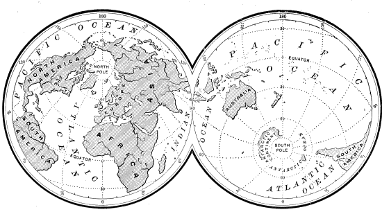
Fig. 101.—Map showing how the land clusters about the north pole.
An obvious objection to the theory of a late Tertiary or post-Tertiary subsidence of the Isthmus of Panama presents itself in the fact that there is at present a complete diversity of species between the fish inhabiting the waters upon the different sides of the isthmus. If there had been such a subsidence, it seems natural to suppose that Atlantic species would have migrated to the Pacific side and obtained a permanent lodgment there, and that Pacific species would have found a congenial home on the Atlantic side. It must be confessed that this is a serious theoretical difficulty, but perhaps not insuperable. For it is by no means certain that colonists from the heated waters of the Caribbean Sea would become so permanently established upon the Pacific side that they could maintain themselves there upon the re-establishment of former conditions. On the contrary, it seems reasonable to suppose that upon the re-elevation of the isthmus the northern currents, which would then resume their course, would bring back with them conditions unfavourable to the Atlantic species, and favourable to the competing species which had only temporarily withdrawn from the field, and which might now be better fitted than ever to renew the struggle with their Atlantic competitors. It is by no means certain, therefore, that with the re-establishment of the former conditions there would not also be a re-establishment of the former equation of life upon the two sides of the isthmus.
Mr. Upham’s theory involves also extensive elevations of land in the northern part of America; in this respect agreeing with the opinions early expressed by Professors J. D. Dana and J. S. Newberry. Of the positive indications of such northward elevations of land we have already spoken when treating in a previous chapter of the fiords and submerged channels which characterise northern Europe and both the eastern and the western coasts of North America. But in working out the problem the solution is only half reached when we have got the Gulf Stream into the Pacific Ocean, and the land in the northern part of the continents elevated to some distance above its present level. There is still the difficulty of getting the moisture-laden currents from the Pacific Ocean to carry their burdens over the crest of the Sierra Nevada and Rocky Mountains and to deposit them in snow upon the Laurentian highlands. An ingenious supplement to the theory, therefore, has been brought forward by Professor Carpenter, who suggests that the immense Tertiary and post-Tertiary lava-flows which cover so much of the area west of the Rocky Mountains were the cause of the accumulations of snow which formed the Laurentide Glacier. This statement, which at first seems so paradoxical as to be absurd, appears less so upon close examination.
The extent of the outflows of lava west of the Rocky Mountains is almost beyond comprehension. Literally, hundreds of thousands of square miles have been covered by them to a depth in many places of thousands of feet. These volcanic eruptions are mostly of late date, beginning in the middle of the Tertiary and culminating probably about the time of the maximum extent of the Laurentide Glacier. Indeed, so nearly contemporaneous was the growth of the Laurentide Glacier with these outflows that Professor Alexander Winchell had, with a good deal of plausibility, suggested that the outflows of the eruptions of lava were caused by the accumulation of ice over eastern British America. His theory was that the three million cubic miles of ice which is proved to have been abstracted from the ocean and piled up over that area was so serious a disturbance of the equilibrium of the earth’s crust that it caused great fissures to be opened along the lines of weakness west of the Rocky Mountains, and pressed the liquid lava out, as the juice is pressed out of an orange in one place by pressing upon the rind in another.
Professor Carpenter’s view is the exact reverse of Professor Winchell’s. Going back to those orographic changes which produced the lava-flows and the elevation of the northern part of British America, he thinks the problem of getting the moisture transferred from the Pacific Ocean to the Canadian highlands is solved by the lava-flows west of the Rocky Mountains. This immense exudation of molten matter was accompanied by an enormous liberation of heat, which must have produced significant changes in the meteorological conditions.
The moisture of the atmosphere is precipitated by means of the condensation connected with a lowering of its temperature. Ordinarily, therefore, when moist winds from an oceanic area pass directly over a lofty mountain-chain, the precipitation takes place immediately, and the water finds its way back by a short course to the sea. This is what now actually occurs on the Pacific coast. The Sierra Nevada condense nearly all the moisture; so that very little falls on the vast area extending from their summits eastward to the Rocky Mountains. All that region is now practically a desert land, where the evaporation exceeds the precipitation. In Professor Carpenter’s view the heat radiated from the freshly exuded lava is supposed to have prevented the precipitation near the coast-line, and to have helped the winds in carrying it farther onward to the northeast, where it would be condensed upon the elevated highlands, upon which the snows of the great Laurentide Glacier were collected.
It is not necessary for us to attempt to measure the amount of truth in this subsidiary hypothesis of Professor Carpenter, but it illustrates how complicated are the conditions which have to be considered before we rest securely upon any particular hypothesis. The unknown elements of the problem are so numerous, and so far-reaching in their possible scope, that a cautious attitude of agnosticism, with respect to the cause of the Glacial period, is most scientific and becoming. Still, we are ready to go so far as to say that Mr. Upham’s theory comes nearest to giving a satisfactory account of all the phenomena, and it is to this that Professor Joseph Le Conte gives his cautious approval.
Summarily stated, this theory is, that the passage from the Tertiary to the Quaternary or Glacial period was characterised by remarkable oscillations of land-level, and by corresponding changes of climate, and of ice-accumulation in northern regions; that the northern elevation was connected with subsidence in the equatorial regions; that these changes of land-level were both initiated and, in the main, continued by the interior geological forces of the globe; but that the very continental elevation which mainly brought on the Glacial period added at length, in the weight of the ice which accumulated over the elevated region, a new force to hasten and increase the subsidence, which would have taken place in due time in the natural progress of the orographic oscillations already begun. Professor Le Conte illustrates the subject by the following diagram, which, for simplicity’s sake, treats the Glacial epoch as one; the horizontal line, A B, represents time from the later Pliocene until now; but it also represents the present condition of things both as to land-level and as to ice-accumulation. The full line, c d e, represents the oscillations of land (and presumably of temperature) above and below the present condition. The broken line represents the rise, culmination, and decline of ice-accumulation. The dotted line represents the crust-movement as it would have been if there had been no ice-accumulation.
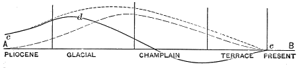
Fig. 102.
Succession of Epochs, Glacial and Fluvial Deposits, and Changes in Altitude and Climate, during the Quaternary Era.
Epochs. Eastern Provinces and New England. Middle and Southern Atlantic States.
Recent or Terrace. (Mostly within the period of traditional and written history.) Rise of the land to its present height, or somewhat higher, soon after the departure of the ice. Rivers eroding their glacial flood-plains, leaving remnants as terraces. Warmer climate than now, probably due to greater Gulf Stream, formerly permitted southern mollusks to extend to Gulf of St. Lawrence, now represented by isolated colonies. Continued subsidence of coast at New York and southward, and rise of the mountainous belt, by displacement along the fall line of the rivers. Much erosion of the Columbia formation since culmination of second Glacial epoch; sedimentation in bays, sounds, and estuaries.
Glacial Period or Ice Age. Pleistocene Period.
Champlain. (Close of the second Glacial epoch.) Land depressed under ice-weight; glacial recession; continued deposition of upper till and deep flood-plains of gravel, sand and clay (modified drift). Terminal moraines marking pauses or readvance during general retreat of ice. Marine submergence. 150 to 230 feet on coast of Maine, to 520 feet in Gulf and valley of St. Lawrence. Less subsidence in latitude of New York and southward than at north; lower Hudson Valley, and part of its present submarine continuation, above sea-level. Gravel and sand deposits from englacial drift in Delaware and Susquehanna Valleys, inclosing abundant human implements at Trenton, N.J.
Second Glacial. Second great uplift of the land, 3,000 to 4,000 feet higher than now; snow-fall again all the year; ice probably two miles thick on Laurentide highlands, and extending somewhat farther south here than in first glaciation. Lower till (ground moraine), and upper till (englacial drift). Terminal moraines, kames, osars, valley drift. Renewal of great continental elevation (3,000 feet in latitude of New York and Philadelphia), of excessive snow-fall and rains, and of wide-spread fluvial deposits, the Columbia formation, on the coastal plain, during early part of this epoch. Implements of man at Claymont, Del.
Inter-glacial. (Longest epoch of this era.) Ice-sheet melted here; probably not more ice in arctic regions than now. Fluvial and lacustrine deposits of this time, with those of the first Glacial epoch, were eroded by the second glaciation. Depression, but generally not to the present level. Deep channels cut in the bed-rocks by the Delaware, Susquehanna, Potomac, and other rivers. The Appomattox deposits much eroded. Relative length of this epoch made known by McGee from study of this region.
First Glacial. Begun by high continental uplift, cool climate and snow-fall throughout the year, producing ice-sheet. Much glacial erosion and transportation; till and stratified deposits. Ended by depression of land; return of warm climate, with rain; final melting of the ice. Isthmus of Panama probably submerged (Gulf Stream smaller), and again in second Glacial epoch. Continental elevation; erosion of Delaware and Chesapeake Bays, and of Albemarle and Pamlico Sounds. Plentiful snow-fall on the southern Appalachian Mountains; snows melted in summer, and heavy rains, producing broad river-floods, with deposition of the Appomattox formation.
Succession of Epochs (cont.)
Mississippi Basin and northward. Cordilleran Region. Europe and Asia.
Terracing of river valleys. Northward rise of area of Lake Agassiz nearly complete before the ice was melted on the country crossed by Nelson River; but rise about Hudson Bay is still going on; 7,000 to 8,000 years since ice-melting uncovered Niagara and falls of St. Anthony. Including a stage of considerable uplift, with return of humid conditions, Alpine glaciation (third Glacial epoch), and the second great rise of Lakes Bonneville and Lahontan. Very recent subsidence and change to present aridity. Erosion and terracing of stratified drift in river valleys. Land passage of European flora to Greenland; succeeded by subsidence there, admitting warm currents to Arctic Sea. Minor climatic changes, including a warmer stage than now. Upper and outer portions of Indo-Gangetic alluvial plain; extensive deposits of Hwang Ho, and destructive changes of its course.
Glacial Period or Ice Age. Pleistocene Period.
Abundant deposition of englacial drift. Stone implements in river gravels of Ohio, Ind., and Minn. Laurentian lakes held at higher levels, and Lake Agassiz formed in Red River basin, by barrier of retreating ice, with outlets over lowest points of their present southern water-shed. Marine submergence 300 to 500 feet on southwest side of Hudson Bay. Depression probably almost to the present level. Restoration of arid climate; nearly or quite complete evaporation of Lakes Bonneville and Lahontan. Formation of the “adobe” continuing through the second Glacial, Champlain, and Recent epochs. Final departure of the ice-sheets; glacial rivers forming eskers and kames. Loess deposited while the region of the Alps was depressed lower than now. Upper (englacial) till, and asar, of Sweden. Marine submergence 500 to 600 feet in Scotland, Scandinavia, and Spitzbergen.
Ice-sheet here less extensive than in the first Glacial epoch, and not generally bordered as then by lakes in valleys which now drain southward. Terminal moraines at extreme limit of the ice-advance, and at ten or more stages of halt or readvance in its retreat. Probable uplift 3,000 feet, shown by submerged valleys near Cape Mendocino. Second ice-sheet on British Columbia and Vancouver Island; local glaciation of Rocky Mountains, Cascade range, and Sierra Nevada, south to latitude 37°. First great rise of Lakes Bonneville and Lahontan. Second elevation and general glaciation of northwestern Europe; the ice-sheets of Great Britain probably more extensive than in first Glacial epoch. Oscillations of ice-front; British Lower and Upper bowlder-clays, the Chalky, Purple, and Hessle bowlder-clays. Terminal moraines in Germany.
Depression nearly to present level southward; more northward, but followed there, by differential uplift of 800 or 1,000 feet. Great erosion of loess and other modified drift, and of “Orange Sand.” Valleys of this epoch, partly filled with later till, are marked by chains of lakes in southern Minnesota. Continental depression. Arid climate. Long-continued denudation of the mountains: resulting very thick subaërial deposits of the “adobe.” Intermittent volcanic action in various parts of this region, throughout the Quaternary era to very recent times, and liable to break forth again. Recession, or probably complete departure, of the ice-sheets. Land connection between Europe and Africa, permitting southern animals to extend far northward. Erosion of the Somme Valley below its oldest implement-bearing gravels.
Pliocene elevation of continent brought to culmination at beginning of Quaternary era; this whole basin probably then uplifted 3,000 feet; excessive snow-fall and rain; deposition of the “Orange Sand.” Ice-sheet south to Cincinnati and St. Louis, at length depressing the earth’s crust beneath it; slackened river floods and shallow lakes, forming the loess. Latest rise (3,000 feet) of the Colorado Cañon district. Sierra Nevada and other Great Basin mountain-ranges formed by immense uplifts, with faulting. California river-courses changed; human bones and implements in the old river gravels, lava-covered. Ice-sheet on British Columbia; local glaciers southward. Uplift and glaciation of northwestern Europe: maximum elevation. 2,500 feet or more (depth of the Skager Rack); France and Britain united with the Färöe Islands, Iceland, and Greenland. Uplifts of the Himalayas and other mountain-ranges attendant on both Glacial epochs.
It is seen from the diagram that the ice-accumulation culminated at a time when the land, under the pressure of the ice-load, had already commenced to subside; and that the subsidence was greatest at a time when the pressure had already begun to diminish. But the fact that the land, after the removal of the ice-load, did not return again to its former height in the Pliocene, is proof positive that there were other and more fundamental causes of crust-movement at work besides weighting and lightening. The land did not again return to its former level because the cycle of elevation, whatever its cause, which commenced in the Pliocene and culminated in the early Quaternary, had exhausted itself. If it had not been for the ice-load interfering with and modifying the natural course of the crust-movement determined previously and primarily by other and probably internal causes, the latter would probably have taken the course represented by the dotted line. It would have risen higher and culminated later, and its curve would have been of simpler form.
We append a carefully prepared table by Mr. Warren Upham, showing the probable changes in altitude and climate during the Quaternary era.[DX]
On the part of many the theory here provisionally adopted will be regarded with disfavour by reason of a disinclination to supposing any great recent changes of level in the continental areas. So firmly established do the continents appear to be, that it seems like invoking an inordinate display of power to have them exalted for the sake of producing a Glacial period. Due reflection, however, will make it evident that within certain limits the continents are exceedingly unstable, and that they have displayed this instability to as great an extent in recent geological times as they have done in any previous geological periods. When one reflects, also, upon the size of the earth, a continental elevation of 3,000 or 4,000 feet upon a globe whose diameter is more than 40,000,000 feet is an insignificant trifle. On a globe one foot in diameter it would be represented by a protuberance of barely one thousandth of an inch. A corresponding wrinkle upon a large apple would require a magnifying-glass for its detection. Moreover, the activity of existing volcanoes, the immense outflows of lava which have taken place in the later geological periods, together with the uniform increase of heat as we penetrate to deeper strata in the crust of the earth—all point to a condition of the earth’s interior that would make the elevations of land which we have invoked for the production of the Glacial period easily credible. Physicists do not, indeed, now hold to the entire fluidity of the earth’s interior, but rather to a solid centre, where gravity overcomes the expansive power of heat, and maintains solidity even when the heat is intense. But between the cooling crust of the earth’s exterior and a central solid core there is now believed to be a film where the influences of heat and of the pressure of gravity are approximately balanced, and the space is occupied by a half-melted or viscous magma, capable of yielding to a slow pressure, and of moving in response to it from one portion of the enclosed space to another where the pressure is for any cause relieved.
As a result of prolonged enquiries respecting the nature of the forces at work both in the interior and upon the exterior of the earth, and of a careful study of the successive changes marking the geological period, we are led to believe that the continental elevations necessary to produce the phenomena of the Glacial period are not only entirely possible but easily credible, and in analogy with the natural progress of geological history. In the first place, it is easy to see that two causes are in operation to produce a contraction of the earth’s volume and a shortening of its diameter. Heat is constantly being abstracted from the earth by conduction and radiation, but perhaps to a greater extent through ceaseless volcanic eruptions which at times are of enormous extent. It requires but a moment’s thought to see that contraction of the volume of the earth’s interior means that the hardened exterior crust must adjust itself by wrinkles and folds. For a long period this adjustment might show itself principally in gentle swells, lifting portions of the continents to a higher level, accompanied by corresponding subsidence in other places. This gradually accumulating strain would at length be relieved along some line of special weakness in the crust by that folding process which has pushed up the great mountain systems of the world.
Careful study of the principal mountain systems shows that all the highest of them are of late geological origin. Indeed, the latter part of the Tertiary period has been the great mountain-building epoch in the earth’s history. The principal part of the elevation of the Andes and the Rocky Mountains has taken place since the middle of the Tertiary period. In Europe there is indubitable evidence that the Pyrenees have been elevated eleven thousand feet during the same period, and that the western Alps have been elevated thirteen thousand feet in the same time. The Carpathians, the western Caucasus, and the Himalayas likewise bear explicit evidence to the fact that a very considerable portion of their elevation, amounting to many thousand feet, has been effected since the middle of the Tertiary period, while a considerable portion of this elevation of the chiefest mountain systems of the world has occurred in what would be called post-Tertiary time—that is, has been coincident with a portion of the Glacial period.
The Glacial period, however, we suppose to have been brought about, not by the specific plications in the earth’s crust which have produced the mountain-chains, but by the gentler swells of larger continental areas whose strain was at last relieved by the folding and mashing together of the strata along the lines of weakness now occupied by the mountain systems. The formation of the mountains seems to have relieved the accumulating strain connected with the continental elevations, and to have brought about a subsequent subsidence.
Doubtless, also, correlated subsidences and elevations of the earth’s crust have been aided by the transfer of the sediment from continental to oceanic areas, and, as already suggested, during the Glacial period by the transfer of water evaporated from the surface of the ocean to the ice-fields of the glaciated area. For example, present erosive agencies are lowering the level of the whole Mississippi basin from the Alleghanies to the Rocky Mountains at the rate of a foot in five thousand years. All this sediment removed is being transferred to the ocean-bed. Present agencies, therefore, if not counteracted, would remove the whole continent of America (whose average elevation above the sea is only 748 feet) in less than four million years; while the great rivers which descend in all directions from the central plateau of Asia are transferring sediment to the ocean from two to four times as fast as the Mississippi is, and the Po is transferring it from the Alps to the Adriatic fully seven times as fast as the Mississippi is from its basin to the Gulf of Mexico. This rapid transfer of sediment from the continents to the ocean is producing effects in disturbing the present equilibrium of the earth’s crust, which are too complicated for us fully to calculate; but it is by no means improbable that when accumulating for a considerable length of time, the ultimate results may be very marked and perhaps sudden in their appearance.
The same may also be said of the accumulation of ice during the Glacial period. The glaciated areas of North America and Europe combined comprise about six million square miles. At a moderate estimate, the ice was three-quarters of a mile deep. Here, therefore, there would be between four and five million cubic miles of water, which had first relieved the ocean-beds of the pressure of its weight, and then concentrated its force over the elevated areas of the northern hemisphere. This disturbance of the equilibrium, by the known transfer of force from one part of the earth’s crust to another, certainly gives much plausibility to the theory of Jamieson, Winchell, Le Conte, and Upham, that the Glacial period partly contained in itself its own cure, and by the weight of its accumulated weight of ice helped to produce that depression over the glaciated area which at length rendered the accumulation of ice there impossible.
This general view of the known causes in operation during the Glacial period will go far towards answering an objection that has probably before this presented itself to the reader’s mind. It seems clear that the Glacial period in the southern hemisphere has been nearly contemporaneous with that of the northern. The Glacial period proper of the southern hemisphere is long since passed. The existing glaciers of New Zealand, of the southern portion of the Andes Mountains, and of the Himalaya Mountains are but remnants of those of former days. In the light of the considerations just presented, it would not seem improbable that the same causes should produce these similar effects in the northern and the southern hemisphere contemporaneously. At any rate, it would not seem altogether unlikely that the pressure of ice during the climax of the Glacial period upon the northern hemisphere (which, as we have seen, there is reason to believe aided in the depression of the continent to below its present level in the latter part of the Glacial period) should have contributed towards the elevation of mountains in other parts of the world, and so to the temporary enlargement of the glaciers about their summits.
Nor are we wholly without evidence that these readjustments of land-level which have been carried on so Vigorously since the middle of the Tertiary period are still going on with considerable though doubtless with diminished rapidity. There has been a re-elevation of the land in North America since the Glacial period amounting to 230 feet upon the coast of Maine, 500 feet in the vicinity of Montreal, from 1,000 to 1,600 feet in the extreme northern part of the continent, and in Scandinavia to the extent of 600 feet. In portions of Scandinavia the land is now rising at the rate of three feet in a century. Other indications of even the present instability of the earth’s surface occur in numbers too numerous to mention.[DY]
But, while we are increasingly confident that the main causes of the Glacial period have been changes in the relative relation of land-levels connected with diversion of oceanic currents, it is by no means impossible, as Wallace[DZ] and others have suggested, that these were combined with the astronomical causes urged by Drs. Croll and Geikie. By some this combination is thought to be the more probable, because of the extreme recentness of the close of the Glacial period, as shown by the evidence which will be presented in the following chapter. The continuance of glaciers in the highlands of Canada, down to within a few thousand years of the present time, coincides in a remarkable manner with the last occurrence of the conditions favourable to glaciation upon Mr. Croll’s theory, which took place about eleven thousand years ago.
CHAPTER X.
THE DATE OF THE GLACIAL PERIOD.
In approaching the subject of glacial chronology, we are compelled to recognise at the outset the approximate character of all our calculations. Still, we shall find that there are pretty well-defined limits of time beyond which it is not reasonable to place the date of the close of the Glacial period; and, where exact figures cannot be determined, it may yet be of great interest and importance to know something near the limits within which our speculations must range.
For many years past Mr. Croll’s astronomical theory as to the cause of the Glacial period has been considered in certain circles as so nearly established that it has been adopted by them as a chronological table in which to insert a series of supposed successive Glacial epochs which are thought to have characterised not merely the Quaternary epoch but all preceding geological eras. What we have already said, however, respecting the weakness of Mr. Croll’s theory is probably sufficient to discredit it as a chronological apparatus. We will therefore turn immediately to the more tangible evidences bearing upon the subject.
The data directly relating to the length of time which separates the present from the Glacial period are mainly connected with two classes of facts:
1. The amount of erosion which has been accomplished by the river systems since the Glacial period; and 2. The amount of sedimentation which has taken place in lakes and kettle-holes. We will consider first the evidence from erosion.
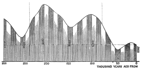
Fig. 103.—Diagram of eccentricity and precession: Abscissa represents time and ordinates, degrees of eccentricity and also of cold. The dark and light shades show the warmer and colder winters, and therefore indicate each 10,500 years, the whole representing a period of 300,000 years.
The gorge below Niagara Falls affords an important chronometer for measuring the time which has elapsed since a certain stage in the recession of the great North American ice-sheet. As already shown, the present Niagara River is purely a post-glacial line of drainage;[EA] the preglacial outlet to Lake Erie having been filled up by glacial deposits, so that, on the recession of the ice, the lowest level between Lake Erie and Lake Ontario was in the line of the trough of the present outlet. But, from what has already been said, it also appears that the Niagara River did not begin to flow until considerably after the ice-front had withdrawn from the escarpment at Queenston, where the river now emerges from its cañon to the low shelf which borders Lake Ontario. For a considerable period afterwards the ice continued to block up the easterly and northerly outlets through the valleys of the Mohawk and of the St. Lawrence, and held the water in front of the ice up to the level of the passes leading into the Mississippi Valley. Niagara River, of course, was not born until these ice-barriers on the east and northeast melted away sufficiently to allow the drainage to take its natural course.
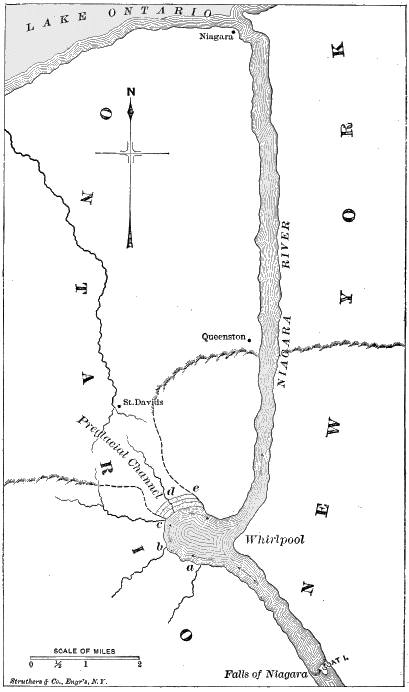
Fig. 104.—Map of the Niagara River below the falls, showing the buried channel from the whirlpool to St. Davids. Small streams, a, b, c, fall into the main gorge over a rocky escarpment. No rock appears in the channel at d, but the rocky escarpment reappears at e.
Of these barriers, that across the Mohawk Valley doubtless gave way first. This would allow the confluent waters of this great glacial lake to fall down to the level of the old outlet from the basin of Lake Ontario into the Mohawk Valley, in the vicinity of Home, N. Y. The moment, however, that the water had fallen to this level, the plunging torrents of Niagara would begin their work; and the gorge extending from Queenston up to the present falls is the work done by this great river since that point of time in the Glacial period when the ice-barrier across the Mohawk Valley broke away.
The problem is therefore a simple one. Considering the length of this gorge as the dividend, the object is to find the rate of annual recession; this will be the divisor. The quotient will be the number of years which have elapsed since the ice first melted away from the Mohawk Valley. We are favoured in our calculation by the simplicity of the geologic arrangement.
The strata at Niagara dip slightly to the south, but not enough to make any serious disturbance in the problem. That at the surface, over which the water now plunges, consists of hard limestone, seventy or eighty feet in thickness, and this is continuous from the falls to the face of the escarpment at Queenston, where the river emerges from the gorge. Immediately underneath this hard superficial stratum there is a stratum of soft rock, of about the same thickness, which disintegrates readily. As a consequence, the plunging water continually undermines the hard stratum at the surface, and prepares the way for it to fall down, from time to time, in huge blocks, which are, in turn, ground to powder by the constant commotion in which they are kept, and thus the channel is cleared of débris.
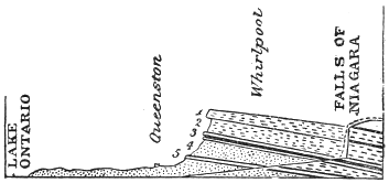
Fig. 105.—Section of strata along the Niagara gorge from the falls to the lake: 1, 3, strata of hard rock; 2, 4, of soft rock.
Below these two main strata there is considerable variation in the hardness of the rock, as shown in the accompanying diagram, where 3 and 5 are hard strata separated by a soft stratum. In view of this fact it seems probable that, for a considerable period in the early part of the recession, instead of there being simply one, there was a succession of cataracts, as the water unequally wore back through the harder strata, numbered 5, 3, and 1; but, after having receded half the distance, these would cease to be disturbing influences, and the problem is thus really the simple one of the recession through the strata numbered 1 and 2, which are continuous. So uniform in consistency are these throughout the whole distance, that the rate of recession could never have been less than it is now. We come, therefore, to the question of the rapidity with which the falls are now receding.
In 1841 Sir Charles Lyell and Professor James Hall (the State Geologist of New York) visited the falls together, and estimated that the rate of recession could not be greater than one foot a year, which would make the time required about thirty-five thousand years. But Lyell thought this rate was probably three times too large; so that he favoured extending the time to one hundred thousand years. Before this the eminent French geologist Desor had estimated that the recession could not have been more than a foot in a century, which would throw the beginning of the gorge back more than three million years. But these were mere guesses of eminent men, based on no well-ascertained facts; while Mr. Bakewell, an eminent English geologist, trusting to the data furnished him by the guides and the old residents of Niagara, had, even then, estimated that the rate of recession was as much as three feet a year, which would reduce the whole time required to about ten thousand years.