Front matter (continued 3)
Reading edition
That the glacial movement extended to the southern boundary just delineated is established by the presence down to that line of all the signs of glacial action, and their absence beyond. Glacial groovings are found upon the freshly uncovered rock surfaces at frequent intervals in close proximity to the line all along its course, while granitic boulders from the far north are scattered, with more or less regularity, over the whole intervening space between this line and the Canadian highlands. I have already referred to a boulder of jasper conglomerate found in Boone County, Kentucky, which must have come from unique outcroppings of this rock north of Lake Huron. Granitic boulders from the Lake Superior region are also found in great abundance at the extreme margin mentioned in southern Illinois. West of the Missouri River it is somewhat more difficult to delineate the boundary with accuracy, on account of an enveloping deposit of fine loam, technically called “loess.” Loess is very abundant in the whole valley of the Missouri River below Yankton, South Dakota, being for a long distance in the vicinity of the river a hundred feet or more in depth. Over northern Missouri and southern Illinois the deposit is nearly continuous, but less in depth, and everywhere in that region tends to hide from view the unstratified glacial deposit continuously underlying it.
A single instance of personal experience will illustrate the condition of things. While going south from Chicago, in search of the southern limit of glacial action, I stopped off from the train at Du Quoin, about forty miles north of where I subsequently found the boundary. Here the whole surface was covered with loess, two or three feet in depth. Below this was a gravelly soil, three or four feet in thickness, which contained many scratched pebbles of granite. A well which had recently been dug, reached the rock at a depth of twenty feet, and revealed a beautifully polished and scratched surface, betraying, beyond question, the action of glacial ice. As we shall show a little later, it is probable that, about the time the ice of the Glacial period had reached its maximum development, this area, which is covered with loess, was depressed in level, and remained under water during a considerable portion of the period when the ice-front was retreating.
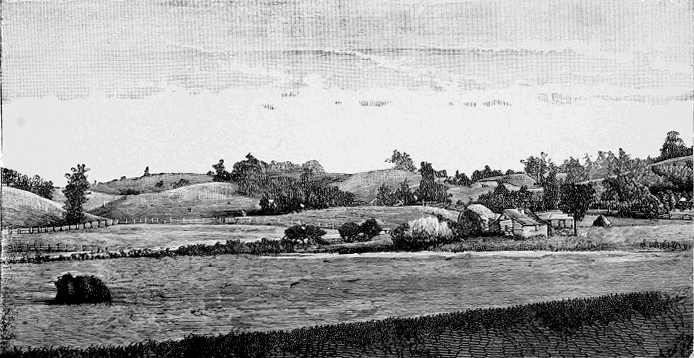
Fig. 33.—Western face of the kettle-moraine, near Eagle, Waukesha County, Wisconsin. (From a photograph by President T. C. Chamberlain, United States Geological Survey.)
To such an extent is this portion of the area included in southern Iowa, northern Missouri, southern Illinois, and the extreme southern portions of Indiana and Ohio covered with loess, that it has been difficult to determine the relation of its underlying glacial deposits to the more irregular deposits found farther north. At an early period of recent investigations, while making a geological survey of the State of Wisconsin, President T. C. Chamberlin fixed upon the line of moraine hills, which can be seen upon our map, running southward between Green Bay and Lake Michigan, and sweeping around in a curve to the right, passing south of Madison and northward along the line of Wisconsin River, and in another curve to the left, around the southern end of Lake Michigan, as the “terminal moraine of the second Glacial epoch.” In Wisconsin the character of this line of moraine hills had been discovered and described by Colonel Charles Whittlesey, in 1866. It was first named the “kettle-moraine,” because of the frequent occurrence in it of “kettle-holes.” This line of moraine hills has been traced with a great degree of confidence across the entire glaciated area, as shown upon our map, but it is not everywhere equally distinct, and, as will be observed, follows a very irregular course.
Beginning in Ohio we find it coinciding nearly with the extreme glacial boundary until it reaches the valley of the Scioto River, on the sixth meridian west from Washington, where it begins to bear northward and continues in that direction for a distance of sixty or seventy miles, and then turns southward again in the valley of the Miami, having formed between these two valleys a sort of medial moraine.[BE] A similar medial moraine had also been noted by President Chamberlin between the valleys of the Grand and Cuyahoga Rivers, in the eastern part of Ohio. Indeed, for the whole distance across Ohio and Indiana, this moraine occurs in a series of loops pointing to the south, corresponding in general to the five gentle valleys which mark the territory, namely, those of the Grand and Mahoning Rivers; the Sandusky and Scioto Rivers; the Great Miami River; the White River; and the Maumee and Wabash Rivers. Everywhere, however, over this area these morainic accumulations approximate pretty closely to the extreme boundary of the glaciated region.
In Illinois President Chamberlin’s original determination of the moraine fixed it near the southern end of Lake Michigan, as shown upon our map, but Mr. Frank Leverett has subsequently demonstrated that there is a concentric series of moraines south of this, reaching across the State, (but somewhat obscured by superficial accumulations of loess referred to) and extending nearly to the latitude of St. Louis.
West of Wisconsin President Chamberlin’s “terminal moraine of the second Glacial epoch” bends southward through eastern Minnesota, and, sweeping down through central Iowa, forms, near the middle of the northern part of that State, a loop, having its southern extremity in the vicinity of Des Moines. The western arm of this loop runs through Minnesota in a northwesterly direction nearly parallel with the upper portion of the valley of the Minnesota, until reaching the latitude of the head-waters of that river, where, in the vicinity of the Sisseton Agency, in Dakota, it turns to the south by an acute angle, and makes a loop in that State, extending to the vicinity of Yankton, and with the valley of the James River as its axis. The western arm of this loop follows pretty closely the line of the eastern edge of the trough of the Missouri River, constituting what is called the “Missouri Coteau,” which continues on as a well-marked line of hills running in a northwesterly direction far up into the Dominion of Canada.
One of the most puzzling glacial phenomena in the Mississippi Valley is the driftless area which occupies the southeastern portion of Minnesota, the southwestern part of Wisconsin, and the northwestern corner of Iowa, as delineated upon our map. This is an area which, while being surrounded on every side by all the characteristic marks of glaciation, is itself conspicuous for their entire absence. Its rocks preserve no glacial scratches and are covered by no deposits of till, while northern boulders avoided it in their journey to more southern latitudes.
The reason for all this is not evident in the topography of the region. The land is not higher than that to the north of it, nor is there any manifest protection to it by the highlands south of Lake Superior. Nor yet is there any reason to suppose that any extensive changes of level in former times seriously affected its relations to the surrounding country. Professor Dana, however, has called attention to the fact that even now it is in a region of comparatively light precipitation, suggesting that the snow-fall over it may always have been insignificant in amount. But this could scarcely account for the failure of the great ice-wave of the north to overrun it. We are indebted again to the sagacity of President Chamberlin in suggesting the true explanation.
By referring to the map it will be noticed that this area sustains a peculiar relation to the troughs of Lake Michigan and Lake Superior, while from the arrangements of the moraines in front of these lakes it will be seen that these lake basins were prominent factors in determining the direction of the movement of the surplus ice from the north. It is the more natural that they should do so because of their great depth, their bottoms being in both cases several hundred feet below the present water-level, reaching even below the level of the sea.
These broad, deep channels seem to have furnished the readiest outlet for the surplus ice of the North, and so to have carried both currents of ice beyond this driftless area before they became again confluent. The slight elevation south of Lake Superior served to protect the area on account of the feebleness of direct movement made possible by the strength of these diverging lateral ice-currents. The phenomenon is almost exactly what occurs where a slight obstruction in a river causes an eddy and preserves a low portion of land below it from submergence. A glance at the map will make it easily credible that an ice-movement south of Manitoba, becoming confluent with one from Lake Superior, pushed far down into the Missouri Valley and spread eastward to the Mississippi River, south of the unglaciated driftless area, and there became confluent with a similar movement which had been directed by the valleys of Lake Michigan and Lake Erie. There can be little doubt that President Chamberlin’s explanation is in the main correct, and we have in this another illustration of the analogy between the behaviour of moving ice and that of moving water.
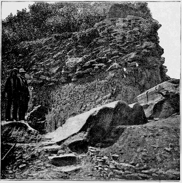
Fig. 34.—Section of the east-and-west glacial furrows, on Kelly’s Island, preserved by Mr. Younglove. Fine sediment rests immediately on the rock, with washed pebbles at the surface.
The accompanying illustrations will give a better idea than words can do of the celebrated glacial grooves on the hard limestone islands near Sandusky, in the western part of Lake Erie. Through the interest aroused in them by an excursion of the American Association for the Advancement of Science, while meeting in Cleveland, Ohio, in 1888, the Kelly Island Lime and Transport Company, of which Mr. M. C. Younglove is the president, has been induced to deed to the Western Reserve Historical Society for preservation a portion of one of the most remarkable of the grooves still remaining.
The portion of the groove preserved is thirty-three feet across, and the depth of the cut in the rock is seventeen feet below the line, extending from rim to rim. Originally there was probably here a small depression formed by preglacial water erosion, into which the ice crowded the material, which became its graving-tool, and so the rasping and polishing went on in increasing degree until this enormous furrow is the result. The groove, however, is by no means simple, but presents a series of corrugations merging into each other by beautiful curves. When exposed for a considerable length it will resemble nothing else so much as a collection of prostrate Corinthian columns lying side by side on a concave surface.
The direction of these grooves is a little south of west, corresponding to that of the axis of the lake. This is nearly at right angles to the course of the ice-scratches on the summit of the water-shed south of this, between the lake and the Ohio River. The reason for this change of direction can readily be seen by a little attention to the physical geography. The highlands to the south of the lake rise about seven hundred feet above it. When the Ice period was at its climax and overran these highlands, the ice took its natural course at right angles to the terminal moraine and flowed southeast according to the direction indicated by the scratches on the summit; but when the supply of ice was not sufficient to overrun the highlands, the obstruction in front turned the course and the resultant was a motion towards Toledo and the Maumee Valley, where in the vicinity of Fort Wayne an extensive terminal moraine was formed.
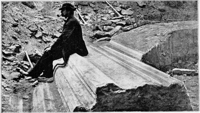
Fig. 35.—Same as the preceding. (Courtesy of M. C. Younglove.)
The much-mooted question of a succession of glacial epochs finds the most of its supporting facts in the portion of the glaciated area lying west of Pennsylvania. That there have been frequent oscillations of the glacial front over this area is certain. But it is a question whether the glacial deposits south of this distinct line of moraine hills are so different from those to the north of it as to necessitate the supposition of two entirely distinct glacial epochs. This can be considered most profitably here.
The following are among the points with reference to which the phenomena south of the moraine just delineated differ from those north of the line:
1. The glacial deposits to the south appear to be distributed more uniformly than those to the north. To the north the drift is often accumulated in hills, and is dotted over with kettle-holes, while to the south these are pretty generally absent. Any one travelling upon a line of railroad which traverses these two portions of the glaciated area as indicated upon our map can easily verify these statements.
2. The amount of glacial erosion seems to be much less south of the line of moraine hills delineated than north of them. Still, glacial striæ are found, almost everywhere, close down to the extreme margin of the glaciated area.
3. The gravel deposits connected with the drainage of the Glacial period are much less abundant south of the so-called “terminal moraine of the second Glacial period” than they are north of it. South of this moraine the water deposits attributed to the Glacial period are of such fine silt as to indicate slow-moving currents over a gentle low slope of the surface.
4. The glacial deposits to the south are more deeply coloured than those to the north, showing that they have been longer exposed to oxidising agencies. Even the granitic boulders show the marks of greater age south of this line, being disintegrated to a greater extent than those to the north.
5. And, finally, there occur, over a wide belt bordering the so-called moraine hills of the second Glacial epoch, extensive intercalated beds of vegetal deposits. Among the earliest of these to be discovered were those of Montgomery County, Ohio, where, in 1870, Professor Orton, of the Ohio Survey, found at Germantown a deposit of peat fourteen feet thick underneath ninety-five feet of till, and there seem also to be glacial deposits underneath the peat as well as over it. The upper portion of the peat contains “much undecomposed sphagnous mosses, grasses, and sedges, and both the peat and the clayey till above it” contain many fragments of coniferous wood which can be identified as red cedar (Juniperus Virginianus). In numerous other places in that portion of Ohio fresh-appearing logs, branches, and twigs of wood are found underneath the till, or mingled with it, much as boulders are. Near Darrtown, in Butler County, Ohio, red cedar logs were found under a covering of sixty-five feet of till, and so fresh that the perfume of the wood is apparently as strong as ever. Similar facts occur in several other counties in the glaciated area of southern Ohio and southern Indiana. Professor Collett reports that all over southwestern Indiana peat, muck, rotted stumps, branches, and leaves of trees are found from sixty to one hundred and twenty feet below the surface, and that these accumulations sometimes occur to a thickness of from two to twenty feet.
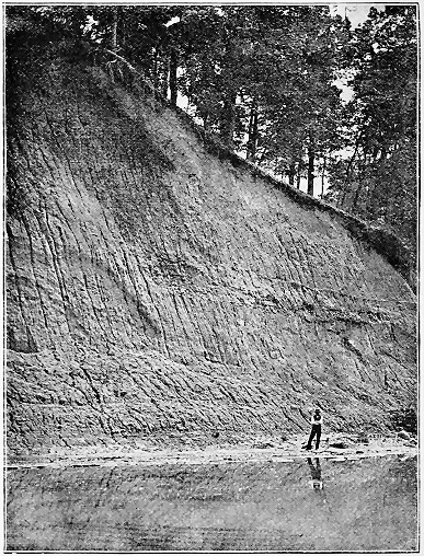
Fig. 36.—Section of till near Germantown, Ohio, overlying thick bed of peat. The man in the picture stands upon a shelf of peat from which the till has been eroded by the stream. The dark spot at the right hand of the picture, just above the water, is an exposure of the peat. The thickness of the till is ninety-five feet. The partial stratification spoken of in the text can be seen about the middle of the picture. The furrows up and down had been made by recent rains. (United States Geological Survey.) (Wright.)
Farther to the northwest similar phenomena occur. Professor N. H. Winchell has described them most particularly in Fillmore and Mower Counties, Minnesota, from which they extend through a considerable portion of Iowa. In the above counties of Minnesota a stratum of peat from eighteen inches to six or eight feet in thickness, with much wood, is pretty uniformly encountered in digging wells, the depth varying from twenty to fifty feet. This county is near the highest divide in the State of Minnesota, and from it “flow the sources of the streams to the north, south, and east.” The wood encountered in this stratum indicates the prevalence f coniferous trees, and the peat mosses indicate a cool and moist climate.
Nor are intercalated vegetable deposits absent from the vast region farther north over the area that drains into Hudson Bay. At Barnesville, in Clay County, Minnesota, which lies in the valley of the Red River of the North, and also in Wilkin County in the same valley, tamarack wood and sandy black mud containing many snail-shells have been found from eight to twelve feet below a surface of till; and Dr. Robert Bell reports the occurrence of limited deposits of lignite between layers of till, far to the northwest, in Canada, and even upon the southern part of Hudson Bay; while Mr. J. B. Tyrrell reports[BF] many indications of successive periods of glaciation near the northern end of the Duck Mountain. The most characteristic indications which he had witnessed consisted of stratified beds of silt, containing fresh-water shells, with fragments of plants and fish similar to those living in the lakes of the region at the present time.
Reviewing these facts with reference to their bearing upon the point under consideration, we grant, at the outset, that they do indicate a successive retreat and readvance of the ice over extensive areas. This is specially clear with respect to the vegetal deposits interstratified with beds of glacial origin. But the question at issue concerning the interpretation of these phenomena is, Do they necessarily indicate absolutely distinct glacial epochs separated by a period in which the ice had wholly disappeared from the glaciated area to the north? That they do, is maintained by President Chamberlin and many others who have wide acquaintance with the facts. That they do not certainly indicate a complete disappearance of the ice during an extensive interglacial epoch, is capable, however, of being maintained, without forfeiting one’s rights to the respect of his fellow-geologists. The opposite theory is thus stated by Dr. Robert Bell: “It appears as if all the phenomena might be referred to one general Glacial period, which was long continued, and consequently accompanied by varying conditions of temperature, regional oscillations of the surface, and changes in the distributions of sea and land, and in the currents in the ocean. These changes would necessarily give rise to local variations in the climate, and might permit of vegetation for a time in regions which need not have been far removed from extensive glaciers.”[BG]
At my request, Professor J. E. Todd, of Iowa, whose acquaintance with the region is extensive, has kindly written out for me his conclusions upon this subject, which I am permitted to give in his own words:
“I am not prepared to write as I would like concerning the forest-beds and old soils. I will, however, offer the following as a partial report. I have come to think that there is considerable confusion on the subject. I believe there are five or six different things classed under one head.
“1. Recent Much and Soils.—The finest example I have found in the whole Missouri Valley was twenty feet below silt and clay, in a basin inside the outer moraine, near Grand View, South Dakota. From my examination of the reported old soil near Albia, Iowa, I think the most rational way of reconciling the conflicting statements concerning it is that it also belongs to this class.
“2. Peat or Soil under Loess.—This does not signify much if the loess was formed in a lake subject to orographic oscillations, or if, as I am coming to believe, it is a fluviatile deposit of an oscillating river like the Hoang-Ho on the great Chinese plain. It at least does not mean an interglacial epoch.
“3. Wood and Dirt rearranged, not in situ.—This occurs either in subaqueous or in subglacial deposits. I have found drift-wood in the lower layers of the loess here, but not in situ. I have frequently found traces of wood in till in Dakota, but always in an isolated way. I think, from reading statements about the deposits in eastern Iowa, that most if not all of the cases are of this sort. Two things have conspired to lead to this error: one, the influence of Croll’s speculation; and the other, the easy inference of many well-diggers, and especially well-borers, that what they pass through are always in layers. In this way a log becomes a forest-bed. Scattered logs and muck fragments occurring frequently in a region, though at different levels, are readily imagined by an amateur geologist to be one continuous stratum antedating the glacier or floods (as the case may be in that particular region), when, in fact, it has been washed down from the margin of the transporting agent and is contemporaneous with it. I suspect the prevalence of wood in eastern Iowa may be traced to a depression of the driftless region during the advance of the glacier, so as to bring the western side of that area more into the grasp of glacial agencies.
“4. Peat between Subglacial Tills.—If cases of this sort are found, they are in Illinois, Indiana, and Ohio. Professor Worthen insisted that there were no interglacial soils or forest-beds in Illinois; and in the cases mentioned in the State reports he repeatedly explains the sections given by his assistants, so as to harmonize them with that statement. I think he usually makes his explanations plausible. He was very confident in referring most of them, to preglacial times. His views, I suppose, will be published in the long-delayed volume, now about to be issued.
“5. Vegetable Matter between Glacial Till and Underlying Berg Till or other Drift Deposits.—When one remembers that the front of the great ice-sheet may have been as long in reaching its southern boundary as in receding from it, and with as many advance and retrograde movements, we can easily believe that much drift material would have outrun the ice and have formed deposits so far ahead of it that vegetation would have grown before the ice arrived to bury it.
“6. Preglacial Soils, etc.—I believe that this will be found to include most in southern Ohio, if not in Illinois, as Worthen claimed.”
The phenomena of the Glacial period are too vast either to have appeared or to have disappeared suddenly. By whatever cause the great accumulation of ice was produced, the advance to the southward must have been slow and its disappearance must have been gradual, though, as we shall show a little later, the final retreat of the ice-front occupied but a short time relatively to the whole period which has elapsed since. As we shall show also, the advent of the Ice period was probably preceded and accompanied by a considerable elevation of the northern part of the continent Whether this elevation was contemporaneous upon both sides of the continent is perhaps an open question; but with reference to the area east of the Rocky Mountains, which is now under consideration, the centre of elevation was somewhere south of Hudson Bay. Putting together what we know, from the nature of the case, concerning the accumulation and movement of glacial ice, and what we know from the relics of the great glacial invasion, which have enabled us to determine its extent and the vigour of its action, the course of events seems to have been about as follows:
Throughout the Tertiary period a warm climate had prevailed over British America, Greenland, and indeed over all the lands in proximity to the north pole, so far as explorers have been able to penetrate them. The vegetation characterizing these regions during the Tertiary period indicates a temperature about like that which now prevails in North Carolina and Virginia. Whatever may be said in support of the theory that the Glacial period was produced by astronomical causes, in view of present facts those causes cannot be regarded as predominant; at most they were only co-operative. The predominant cause of the Glacial period was probably a late Tertiary or post-Tertiary elevation of the northern part of the continents, accompanied with a subsidence in the central portion. Of such a subsidence in the Isthmus of Panama indications are thought to be afforded by the occurrence of late Tertiary or, more probably, post-Tertiary sea-shells at a considerable elevation on the divide along the Isthmus of Panama, between the Atlantic and Pacific Oceans. Of this we shall speak more fully in a later chapter.
Fixing our thoughts upon what is known as the Laurentian plateau, which, though now in the neighbourhood of but two thousand feet above the sea, was then much higher, we can easily depict in imagination the beginnings of the great “Laurentide Glacier,” which eventually extended to the margin already delineated on the south and southwest in the United States, and spread northward and eastward over an undetermined area. Year after year and century after century the accumulating snows over this elevated region consolidated into glacial ice and slowly pushed outward the surplus reservoirs of cold. For a long time this process of ice-accumulation may have been accompanied by the continued elevation of the land, which, together with the natural effect of the enlarging area of ice and snow, would tend to lower the temperature around the margin and to increase still more the central area of accumulation.
The vigour of movement in any direction was determined partly by the shape of the valleys opening southward in which the ice-streams would naturally concentrate, and partly by those meteorological conditions which determine the extent of snow-fall over the local centres of glacial dispersion. For example, the general map of North America in the Ice period indicates that there were two marked subcentres of dispersion for the great Laurentide Glacier, the eastern one being in Labrador and the western one north of Lake Superior. In a general way the southern boundary of the glaciated region in the United States presents the appearance of portions of two circumferences of circles intersecting each other near the eastern end of Lake Erie. These circles, I am inclined to believe, represent the areas over which a semi-fluid (or a substance like ice, which flows like a semi-fluid) would disperse itself from the subcentres above mentioned.
A study of the contour of the country shows that that also, in a general way, probably had something to do with the lines of dispersion. The western lobe of this glaciated area corresponds in its boundary pretty closely with the Mississippi Valley, having the Ohio River approximately as its eastern arm and the Missouri as its western, with the Mississippi River nearly in its north and south axis. The eastern lobe has its farthest extension in the axis of the Champlain and Hudson River Valleys, its western boundary being thrown more and more northward as the line proceeds to the west over the Alleghany Mountains until reaching the longitude of the eastern end of Lake Erie; but this southern boundary is by no means a water-level, nor is the contour of the country such that it could ever have been a water-level. But it conforms in nearly every particular to what would be the resultant arising from a pretty general southward flow of a semi-fluid from the two subcentres mentioned, meeting with the obstructions of the Adirondacks in northern New York and of the broader Appalachian uplift in northern Pennsylvania.
How far south the area of glacial accumulation may have extended cannot be definitely ascertained, but doubtless at an early period of the great Ice age the northern portions of the Appalachian range in New York, New England, New Brunswick, and Nova Scotia became themselves centres of dispersion, while only at the height of the period did all their glaciers become confluent, so that there was one continuous ice-sheet.
In the western portion of the area covered by the Laurentide Glacier, the depression occupied by the Great Lakes, especially Lakes Michigan and Superior, evidently had a marked influence in directing the flow of ice during the stages which were midway between the culmination of the Ice period and both its beginning and its end. This would follow from the great depth of these lakes, the bottom of Lake Michigan being 286 feet below sea-level, and that of Lake Superior 375 feet, making a total depth of water of about 900 and 1,000 feet respectively. Into these oblong depressions the ice would naturally gravitate until they were filled, and they would become the natural channels of subsequent movement in the direction of their longest diameters, while the great thickness of ice in them would make them the conservative centres of glacial accumulation and action after the ice had begun to retreat.
These deductions from the known nature of ice and the known topography of the region are amply sustained by a study of the detailed map showing the glacial geology in the United States. But on this we can represent indeed only the marks left by the ice at various stages of its retreat, since, as already remarked, the marks of each stage of earlier advance would be obliterated by later forward movements. We may presume, however, that in general the marks left by the retreating ice correspond closely with those actually made and obliterated by the advancing movement.
From observations upon the glaciers of Switzerland and of Alaska, it is found that neither the advance nor the retreat of these glaciers is constant, but that, in obedience to meteorologic agencies not fully understood, they advance and retreat in alternate periods, at one time receding for a considerable distance, and at other times regaining the lost ground and advancing over the area which has been uncovered by their retreat.
“M. Forel reports, from the data which he has collected with much care, that there have been in this century five periods in the Alpine glaciers: of enlargement, from 1800 (?) to 1815; of diminution, from 1815 to 1830; of enlargement, from 1830 to 1845; of diminution, from 1845 to 1875; and of enlargement again, from 1875 onward. He remarks further that these periods correspond with those deduced by Mr. C. Lang for the variations for the precipitations and temperature of the air; and, consequently, that the enlargement of the glaciers has gone forward in the cold and rainy period, and the diminution in the warm and the dry.”[BH]
When, now, we attentively consider the combination of causes necessary to produce the climatic conditions of the great Ice age of North America, we shall be prepared to find far more extensive variations in the progress of the continental glacier, both during its advance and during its retreat, than are to be observed in any existing local glaciers.
With respect to the arguments adduced in favor of a succession of glacial epochs in America the following criticisms are pertinent:
1. So far as we can estimate, a temporary retreat of the front, lasting a few centuries, would be sufficient to account for the vegetable accumulations that are found buried beneath the glacial deposits in southern Ohio, Indiana, central Illinois, and Iowa, while a temporary readvance of the ice would be sufficient to bury the vegetable remains beneath a freshly accumulated mass of till. Thus, as Dr. Bell suggested, the interglacial vegetal deposits do not necessarily indicate anything more than a temporary oscillation of the ice-front, and do not carry with them the necessity of supposing a disappearance of the ice from the whole glaciated area. Thus the introduction of a whole Glacial period to account for such limited phenomena is a violation of the well-known law of parsimony, which requires us in our explanations of phenomena to be content with the least cause which is sufficient to produce them. In the present instance a series of comparatively slight oscillations of the ice-front during a single glacial period would seem to be sufficient to account for all the buried forests and masses of vegetal débris that occur either in the United States or in the Dominion of Canada.
2. Another argument for the existence of two absolutely distinct glacial periods in North America has been drawn from the greater oxidation of the clays and the more extensive disintegration of certain classes of the boulders found over the southern part of the glaciated area of the Mississippi Valley, than has taken place in the more northerly regions. Without questioning this statement of fact (which, however, I believe to be somewhat exaggerated), it is not difficult to see that the effects probably are just what would result from a single long glacial period brought about by such causes as we have seen to be probably in operation in America. For if one reflects upon the conditions existing when the Glacial period began, he will see that, during the long ages of warm climate which characterised the preceding period, the rocks must have been extensively disintegrated through the action of subaërial agencies. The extent to which this disintegration takes place can be appreciated now only by those who reside outside of the glaciated area, where these agencies have been in uninterrupted action. In the Appalachian range south of the glaciated region the granitic masses and strata of gneiss are sometimes found to be completely disintegrated to a depth of fifty or sixty feet; and what seem to be beds of gravel often prove in fact to be horizontal strata of gneiss from which the cementing material has been removed by the slow action of acids brought down by the percolating water.
Now, there can be no question that this process of disintegration had proceeded to a vast extent before the Glacial period, so that, when the ice began to advance, there was an enormous amount of partially oxidised and disintegrated material ready to be scraped off with the first advance of ice, and this is the material which would naturally be transported farthest to the south; and thus, on the theory of a single glacial period, we can readily account for the greater apparent age of the glacial débris near the margin. This débris was old when the Glacial period began.
3. With reference to the argument for two distinct glacial periods drawn from the smaller apparent amount of glacial erosion over the southern part of the glaciated area, we have to remark that that would occur in case of a single ice-invasion as well as in case of two distinct ice-invasions, in which the later did not extend so far as the former.
From the very necessity of the case, glacial erosion diminishes as the limit of the extent of the glaciation is approached. At the very margin of the glacier, motion has ceased altogether. Back one mile from the margin only one mile of ice-motion has been active in erosion, while ten miles back from its front there has been ten times as much moving ice actually engaged in erosion, and in the extreme north several hundred times as much ice, Thus it is evident that we do not need to resort to two glacial periods to account for the relatively small amount of erosion exhibited over the southern portion of our glaciated area.
At the same time, it should be said that the indications of active glacial erosion near the margin are by no means few or small. In Lawrence County, Pennsylvania, on the very margin of the glaciated area, Mr. Max Foshay[BI] has discovered very extensive glacial grooves, indicating much vigour of ice-action even beyond the more extensive glacial deposits which Professor Lewis and myself had fixed upon as the terminal moraine. In Highland and Butler Counties, Ohio, and in southwestern Indiana and southern Illinois, near the glacial margin, glacial grooves and striæ are as clear and distinct in many cases as can anywhere be found; while upon the surface of the limestone rocks within the limits of the city of St. Louis, where the glacial covering is thin, and where disintegrating agencies had had special opportunities to work, I found very clear evidences of a powerful ice-movement, which had planed and scratched the rock surface; and at Du Quoin, Illinois, as already related, the fragments thrown up from the surface of the rock, fifty or sixty feet below the top of the soil, were most beautifully planed and striated. It should be observed, also, that this whole area is so deeply covered with débris that the extent of glacial erosion underneath is pretty generally hid from view.
4. The uniformity of the distribution of the glacial deposits over the southern portion of the glaciated area in the Mississippi Valley is partly an illusion, due to the fact that there was a vast amount of deposition by water over that area during the earlier stages of the ice-retreat. This has been due partly to the gentler slope which would naturally characterise the borders of an area of elevation, and partly to an extensive subsidence which seems to have begun soon after the ice had reached its farthest extent of motion.
It should be borne in mind that at all times a glacier is accompanied by the issue of vast streams of water from its front, and that these of course increase in volume when the climax has been reached and the ameliorating influences begin to melt away the accumulated mass of ice and to add the volume of its water to that produced by ordinary agencies. As these subglacial streams of water poured out upon the more gentle slopes of the area in front of the ice, they would distribute a vast amount of fine material, which would settle into the hollow places and tend to obscure the irregularities of the previous direct glacial deposit.
Such an instance came clearly under my own observation in the vicinity of Yankton, in South Dakota, where, upon visiting a locality some miles from any river, and to which workmen were resorting for sand, I found that the deposit occupied a kettle-hole, filling it to its brim, and had evidently been superimposed by a temporary stream of water flowing over the region while the ice was still in partial occupation of it. Thus, no doubt, in many cases, the original irregularities of the direct glacial deposits have been obliterated, even where there has been no general subsidence.
But, in the area under consideration, the loess, or loam, is so extensive that it is perhaps necessary to suppose that the central portions of the Mississippi Valley were subjected to a subsidence amounting to about five hundred feet; so that the glacial streams from the retreating ice-front met the waters of the ocean in southern Illinois and Indiana; thus accounting for the extensive fine silt which has done so much over that region to obscure the glacial phenomena.
West of the Rocky Mountains.
The glacial phenomena in the United States west of the Rocky Mountains must be treated separately, since American geologists have ceased to speak of an all-pervading ice-cap extending from the north pole. But, as already said, the glaciation of North America has proceeded from two definite centres of ice-accumulation, one of which we have been considering in the pages immediately preceding. The great centre of glacial dispersion east of the Rocky Mountains is the region south of Hudson Bay, and the vast ice-field spreading out from that centre is appropriately named the Laurentide Glacier. The movement of ice in this glacial system was outward in all directions from the Laurentian hills, and extended west several hundred miles, well on towards the eastern foot of the Rocky Mountains.
The second great centre of glacial dispersion occupies the vast Cordilleran region of British Columbia, reaching from the Rocky Mountains on the northeast to the Coast Range of the Pacific on the southwest, a width of four hundred miles. The length is estimated by Dr. Dawson to be twelve hundred miles. The principal centre of ice-accumulation lies between the fifty-fifth and the fifty-ninth parallel. From this centre the movement was in all directions, but chiefly to the northwest and to the south. The movement of the Cordilleran glaciers extended northwest to a distance of three hundred and fifty miles, leaving their moraines far down in the Yukon Valley on the Lewes and Pelly Rivers.[BJ] Southward the Cordilleran Glacier moved to a distance of six hundred miles, extending to the Columbia River, in the eastern part of the State of Washington.
From this centre, also, the ice descended to the sea-level upon the west, and filled all the channels between Vancouver’s Island and the mainland, as well as those in the Alexander Archipelago of Alaska. South of Vancouver’s Island a glacier pushed out through the straits of Juan de Fuca to an unknown distance. All the islands in Puget Sound are composed of glacial débris, resembling in every respect the terminal moraines which have been described as constituting many of the islands south of the New England coast. The ice-movement in Puget Sound, however, was probably northward, resulting from glaciers which are now represented by their diminutive descendants on the flanks of Mount Rainier.
South of the Columbia River the country was never completely enveloped by the ice, but glaciers extended far down in the valleys from all the lofty mountain-peaks. In Idaho there are glacial signs from the summit of the Rocky Mountains down to the westward of Lake Pend d’Oreille. In the Yellowstone Park there are clear indications that the whole area was enveloped in glacial ice. An immense boulder of granite, resting upon volcanic deposits, may be found a little west of Inspiration Point, on the Yellowstone Cañon. Abundant evidences of glacial action are also visible down the Yellowstone River to the vicinity of Livingston, showing that that valley must have been filled with glacial ice to a depth of sixteen hundred feet. To the west the glaciers from the Yellowstone Park extended to the border of Idaho, where a clearly marked terminal moraine is to be found in the Tyghee Pass, leading over from the western fork of the Madison River into Lewis Fork of the Snake River. South of Yellowstone Park the Teton Mountains were an important centre for the dispersion of local glaciers, but they did not descend upon the western side much below the 6,000-foot level, and only barely came to the edge of the great Snake River lava plains. To the east the movement from the Teton Mountains joined that from various other lofty mountains, where altogether they have left a most intricate system of glacial deposits, in whose reticulations Jackson’s Lake is held in place.
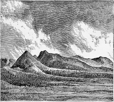
Fig. 37.—Moraines of Grape Creek, Sangre del Cristo Mountains, Colorado (after Stevenson).
In Utah extensive glaciers filled all the northern valleys of the Uintah Mountains, and extended westward in the Wahsatch range to the vicinity of Salt Lake City. The mountain region of Colorado, also, had its glaciers, occupying the head-waters of the Arkansas, the Platte, the Gunnison, and the Grand Rivers. The most southern point in the Rocky Mountains at which signs of local glaciers have been noted is near the summits of the San Juan range, in southwestern Colorado. Here a surface of about twenty-five square miles, extending from an elevation of 12,000 feet down to 8,000 feet, shows every sign of the former presence of moving ice. The greater part of the glaciation in Colorado is confined to elevations above 10,000 feet.
The whole range of the Sierra Nevada through Oregon, and as far south as the Yosemite Valley in California, formerly sustained glaciers of far greater size than any which are now found in those mountains. In general these glaciers were much longer on the western side of the Sierra Nevada than on the eastern. On the eastern side glaciers barely came down to Lake Tahoe and Lake Mono in California. The State of Nevada seems to have been entirely free from glaciers, although it contains numerous mountain-peaks more than ten thousand feet high. In the Yosemite Cañon glaciers extended down the Merced River to the mouth of the cañon; while in the Tuolumne River, a few miles to the north, the glaciers which still linger about the peaks of Mount Dana filled the valley for a distance of forty miles.
It is a question among geologists whether or not the glaciation west of the Rocky Mountains was contemporaneous with that of the eastern part of the continent. The more prevalent opinion among those who have made special study of the phenomena is that the development of the Cordilleran glaciers was independent of that of the Laurentide system. At any rate, the intense glaciation of the Pacific coast seems to have been considerably later than that of the Atlantic region. Of this we will speak more particularly in discussing the questions of the date and the cause of the Glacial period. It is sufficient for us here simply to say that, from his extensive field observations throughout the Cordilleran region, Dr. George M. Dawson infers that there have been several successive alternations of level on the Pacific coast corresponding to successive glacial and interglacial epochs, and that when there was a period of elevation west of the Rocky Mountains there was a period of subsidence to the east, and vice versa. In short, he supposes that the east and west for a long time played a game of seesaw, with the Rocky Mountains as the fulcrum. We give his scheme in tabulated form.
Scheme of Correlation of the Phenomena of the Glacial Period in the Cordilleran Region and in the Region of the Great Plains.
CORDILLERAN REGION. REGION OF THE GREAT PLAINS.
Cordilleran zone at a high elevation. Period of most severe glaciation and maximum development of the great Cordilleran Glacier. Correlative subsidence and submergence of the great plains, with possible contemporaneous increased elevation of the Laurentian axis and maximum development of ice upon it. Deposition of the lower boulder-clay of the plains.
Gradual subsidence of the Cordilleran region and decay of the great glacier, with deposition of the boulder-clay of the interior plateau and the Yukon basin, of the lower boulder-clay of the littoral and probably also, at a later stage (and with greater submergence), of the interglacial silts of the same region. Correlative elevation of the western part, at least, of the great plains, which was probably more or less irregular and led to the production of extensive lakes in which interglacial deposits, including peat, were formed.
Re-elevation of the Cordilleran region to a level probably as high as or somewhat higher than the present. Maximum of second period of glaciation. Correlative subsidence of the plains, which (at least in the western part of the region) exceeded the first subsidence and extended submergence to the base of the Rocky Mountains near the forty-ninth parallel. Formation of second boulder-clay, and (at a later stage) dispersion of large erratics.
Partial subsidence of the Cordilleran region, to a level about 2,500 feet lower than the present. Long stage of stability. Glaciers of the second period considerably reduced. Upper boulder-clay of the coast probably formed at this time, though perhaps in part during the second maximum of glaciation. Correlative elevation of the plains, or at least of their western portion, resulting in a condition of equilibrium as between the plains and the Cordillera, their relative levels becoming nearly as at present. Probable formation of the Missouri coteau along a shore-line during this period of rest.
Renewed elevation of the Cordilleran region, with one well-marked pause, during which the littoral stood about 200 feet lower than at present. Glaciers much reduced, and diminishing in consequence of general amelioration of climate towards the close of the Glacial period. Simultaneous elevation of the great plains to about their present level, with final exclusion of waters in connection with the sea. Lake Agassiz formed and eventually drained towards the close of this period. This simultaneous movement in elevation of both great areas may probably have been connected with a more general northern elevation of land at the close of the Glacial period.
In New Zealand the marks of the Glacial period are unequivocal The glaciers which now come down from the lofty mountains upon the South Island of New Zealand to within a few hundred feet of the sea then descended to the sea-level. The longest existing glacier in New Zealand is sixteen miles, but formerly one of them had a length of seventy-eight miles. One of the ancient moraines contains a boulder from thirty to forty feet in diameter, and the amount of glacial débris covering the mountain-sides is said to be enormous. Reports have also been recently brought of signs of ancient glaciers in Australia.
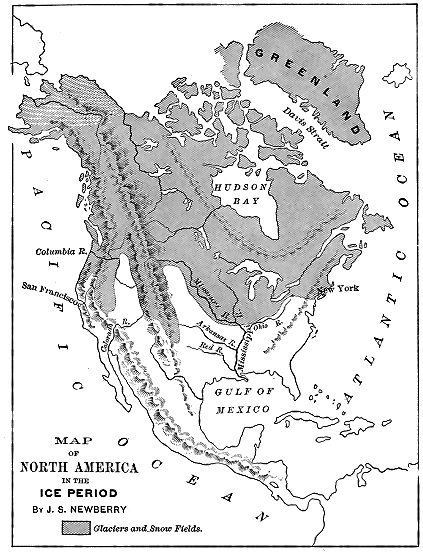
Fig. 38.—Generalised view of the whole glaciated region of North America. The area of motionless ground-ice is shown by the white lines in northern part of Alaska.
According to Darwin, there are distinct signs of glaciation upon the plains of Patagonia sixty or seventy miles east of the foot of the mountains, and in the Straits of Magellan he found great masses of unstratified glacial material containing boulders which were at least one hundred and thirty miles away from their parent rock; while upon the island of Chiloe he found embedded in “hardened mud” boulders which must have come from the mountain-chains of the continent. Agassiz also observed unquestionable glacial phenomena on various parts of the Fuegian coast, and indeed everywhere on the continent south of latitude 37°. Between Concepcion and Arauco, in latitude 37°, Agassiz observed, near the sea-level, a glacial surface well marked with furrows and scratches, and as well preserved, he says, “as any he had seen under the glaciers of the present day.”
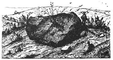
Fig. 39.—Quartzite boulder of 45 cubic metres, on Mont Lachat, 800 metres above the valley of the Belley, in Ain, France (Falsan).
CHAPTER VI.
ANCIENT GLACIERS IN THE EASTERN HEMISPHERE.
About two million square miles of northern Europe were covered with perennial ice during the Glacial period. From the scratches upon the rocks, and from the direction in which material has been transported, it is evident that the main centre of radiation is to be found in the mountains of Scandinavia, and that the glaciers still existing in Norway are the lineal descendants of those of the great Ice age.
So shallow are the Baltic Sea and the German Ocean, that their basins were easily filled with ice, upon which Scandinavian boulders could be transported westward to the east shore of England, southward into the plains of Germany, and eastward far out upon the steppes of Russia. The islands north of Scotland bear marks also of an ice-movement from the direction of Norway. If Scotland itself was not overrun with Scandinavian glaciers, the reason was that it had ice enough of its own, and from its highlands set up a counter-movement, which successfully resisted the invasion from the Scandinavian Peninsula. But, elsewhere in Europe, Scandinavian ice moved freely outward to the extent of its capacity. Then, as now also, the Alps furnished centres for ice-movement, but the glaciers were limited to the upper portions of the valleys of the Rhône, the Rhine, and the Danube upon the west and north, and to a still smaller area upon the southern side.
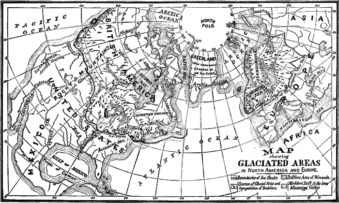
Fig. 40.
Central and Southern Europe.
The main centres of ice-movement in the Alps during the Glacial period are the same as those which furnish the lingering glaciers of the present time. From the water-shed between the Rhine, the Rhône, and the Aar, glaciers of immense size descended all the valleys now occupied by those streams. The valley of the Rhône between the Bernese and the Pennine Alps was filled with a glacier of immense depth, which was maintained by fresh supplies from tributaries upon either side as far down as Martigny. Glacial markings at the head of the Rhône Valley are found upon the Schneestock,[BK] at an elevation above the sea of about 11,500 feet (3,550 metres), or about 1,500 feet above the present surface of the Rhône Glacier. At Fiesch, about twenty miles below, where tributaries from the Bernese Oberland snow-fields were received, the thickness of the glacier was upwards of 5,000 feet (1,680 metres). Near Martigny, about fifty miles farther down the valley, where the glacier was abruptly deflected to the north, the depth of the ice was still upwards of 1,600 metres. From Martigny northward the thickness of the ice decreased rapidly for a few miles, where, at the enlargement of the valley above the head of Lake Geneva, it was less than 1,200 metres in thickness, and spread out over the intervening plain as far as Chasseron, with a nearly level surface, transporting, as we have before said, Alpine boulders to the flanks of the Juras, and landing them about 3,000 feet (1,275 metres) above the level of Lake Geneva. The width of the main valley is here about fifty miles, making the slope of the surface of the ice about twenty feet to the mile.
From its “vomitory,” at the head of Lake Geneva, the ice of the ancient Rhône Glacier spread to the right and to the left, while its northern boundary was abruptly terminated by the line of the Jura Mountains. The law of glacial motion was, however, admirably illustrated in the height to which the ice rose upon the flanks of the Jura. At Chasseron, in the direct line of its onward motion, it rose to its highest point, while both to the southwest and to the northeast, along the line of the Juras, the ice-action was limited to constantly decreasing levels.
Down the valley of the Rhône the direction of motion was determined by the depression of Lake Geneva, at the lower end of which it received its main tributary from Mont Blanc, which had come down from Chamouni through the valley of the river Arve. From this point it was deflected by a spur of the Jura Mountains more and more southward to the vicinity of Culoz, near the mouth of Lake Bourget. Here the glacier coming down from the western flanks of the Alps, through the upper valley of the Isère, past Chambéry, became predominant, and deflected the motion to the west and north, whither the ice extended to a line passing through Bourg, Lyons, and Vienne, leaving upon one of the eminences on which Lyons is built a boulder several feet in diameter, which is duly preserved and labelled in the public park in that portion of the city. Farther south, glaciers of less extent marked the Alps most of the way to the Mediterranean, but they were not at all comparable in size to those from the central region.
To the right of Lake Geneva the movement started by the Rhône Glacier spread eastward, being joined in the vicinity of Berne by the confluent ice-stream which descended from the north flank of the Bernese Oberland, through the valley of the Aar. These united streams filled the whole valley with ice as far down as Soleure.[BL]
Click on map to view larger sized.
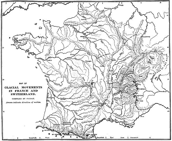
Farther eastward, other ice-streams from the Alps became predominant, one of which, moving down the Reuss, deployed out upon the country lying north of Lucerne and Zug. Still farther down, the ancient glacier which descended the Limmatt spread itself out over the hills and lowlands about Zürich, one of its moraines of retrocession nearly dividing the lake into two portions.
Guyot and others have shown that the superficial deposits of this portion of Switzerland are just such as would be distributed by glaciers coming down from the above-mentioned Alpine valleys. Uniting together north of Zürich, these glaciers pushed onward as far as the Rhine below Schaffhausen. In Frickthal the glacial ice was still 1,200 feet thick, and at Kaisterberg between 400 and 500 feet.
At Lucerne there is a remarkable exposure of pot-holes, and a glaciated surface such as could be produced only by the combined action of moving ice and running water; thus furnishing to tourists an instructive object-lesson. Among the remarkable instances of boulders transported a long distance in Switzerland, is that of a block of granite carried from the Valais to the vicinity of Soleure, a distance of one hundred and fifteen miles, which weighs about 4,100 tons. “The celebrated Pierre-à-Bot, above Neufchâtel, measures 50’ × 20’ × 40’, and contains about 40,000 cubic feet of stone; while the Pierre-des-Marmettes, near Monthey, contains no less than 60,840 cubic feet.”
The ancient glacier of the Rhine, receiving its initial impulse in the same centre as that of the Rhône, fully equalled it in all its dimensions. Descending eastward from its source near the Schneestock to Chur, a distance of fifty miles, it turned northward and continued forty-five miles farther to the head of Lake Constance, where it spread out in fan-shape, extending northwest to Thiengen, below Schaffhausen, and covering a considerable area north and northeastward of the lake, reaching in the latter direction Ulm, upon the Danube—the whole distance of the movement being more than one hundred and fifty miles. Through other valleys tributary to the Danube, glaciers descended upon the upper plains of Bavaria, from the Tyrolese Alps to the vicinity of Munich. From Gross Glockner as a centre in the Noric Alps, vast rivers of ice, of which the Pasterzen Glacier is the remnant, poured far down into the valleys of the Inn and the Enns on the north and into that of the Drave on the southeast. Farther eastward in this part of Europe the mountains seem to have been too low to have furnished centres for any general dispersion of glacial ice.
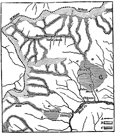
Fig. 41.—Map showing the Lines of Débris extending from the Alps into the Plains of the Po (after Lyell). A. Crest of the Alpine water-shed; B. Névé-fields of the ancient glaciers; C. Moraines of ancient glaciers. Click on image to view larger sized.
Upon the south side of the Alps the ancient glaciers spread far out upon the plains of Lombardy, where moraines of vast extent and of every description enable the student to determine the exact limits of the ancient ice-action. From the southern flanks of Mont Blanc and Monte Rosa, and from the snow-fields of the western Alps, glaciers of great volume descended into the valley of Dora Baltea (vale of Aosta), and on emerging from the mountain valley Spread Out over the plains around Ivrea, leaving moraine hills in some instances 1,500 feet in height. The total length of this glacier was as much as one hundred and twenty miles. From the snow-fields in the vicinity of Mont Cenis, also, glaciers extended down the Dora Ripera to the vicinity of Turin, and down other valleys to a less extent. The lateral moraines of the Diore, on the south side of Mont Blanc, at the head of the Dora Baltea, are 2,000 feet above the present river, and extend upon the left bank for a distance of twenty miles.
From the eastern Alps, glaciers descended through all the valleys of the Italian lakes and deposited vast terminal moraines, which still obstruct the drainage, and produce the charming lakes of that region. A special historic interest pertains to the series of concentric moraines south of Lake Garda, since it was in the reticulations of this glacial deposit that the last great battle for Italian liberty was fought on June 24, 1859. Defeated in the engagements farther up the valley of the Po, the Austrian general Benedek took his final stand to resist the united forces of France and Italy behind an outer semicircle of the moraine hills south of this lake (some of which are 500 or 600 feet above the surrounding country), with his centre at Solferino, about ten miles from Peschera. Here, behind this natural fortification, he awaited the enemy, who was compelled to perform his manœuvres on the open plain which spread out on every side. But the natural fortifications furnished by the moraine hills were too extensive to be defended by an army of moderate size. The troops of Napoleon and Victor Immanuel concentrated at Solferino and broke through the line. Thus the day was lost to the Austrians, and they retired from Lombardy, leaving to Italy both the artificial and the natural fortifications that guard the southern end of this important entrance to the Tyrolese Alps. When once his attention is called to the subject, the traveller upon the railroad cannot fail to notice this series of moraines, as he enters it through a tunnel at Lonato on the west, and emerges from it at Soma Campagna, eighteen or twenty miles distant to the east. A monument celebrating the victory stands upon a moraine hill about half-way between, at Martino della Battaglie.
In other portions of central and southern Europe the mountains were too low to furnish important centres for glacial movements. Still, to a limited extent, the signs of ancient glaciers are seen in the mountains of the Black Forest, in the Harz and Erzgebirge, and in the Carpathians on the east and among the Apennines on the south. In Spain, also, there were limited ice-fields on the higher portions of the Sierra Nevada and in the mountains of Estremadura, and perhaps in some other places. In France, small glaciers were to be found in the higher portions of the Auvergne, of the Morvan, of the Vosges, and of the Cevennes; while, from the Pyrenees, glaciers extended northward throughout nearly their whole extent. The ice-stream descending from the central mass of Maladetta through the upper valley of the Garonne, was joined by several tributaries, and attained a length of about forty-five miles.
The British Isles.
During the climax of the Glacial period the Hebrides to the north of Scotland were covered with ice to a depth of 1,600 feet. How far westward of this it moved out to the sea, it is of course impossible to tell. But in the channels between the Hebrides and Scotland it is evident that the water was completely expelled by the ice, and that, from a height of 1,600 feet above the Hebrides to the northern shores of Scotland, there was a continuous ice-field sloping southward at the rate of about twenty-five feet a mile.
Scotland itself was completely enveloped in glacial ice. Prevented by the Scandinavian Glacier from moving eastward, the Scotch movement was compelled to be westward and southward. On the southwest the ice-stream reached the shores of Ireland, and became confluent with the glaciers that enveloped that island, completely filling the Irish Sea.
There are so many controverted points respecting the glacial geology of England, and they have such an important bearing upon the main question of this volume, that a pretty full discussion of them will be necessary. I have recently been over enough of the ground myself to become satisfied of the general correctness of the views entertained by my late colleague, the lamented Professor Henry Carvill Lewis, whose death in 1888 took place before the publication of his most mature conclusions. But the lines of investigation to which he gave so powerful an impulse have since been followed out by an active body of scientific observers. To give the statement of facts greater precision and authority, I have committed the preparation of it to the Secretary of the Northwest of England Boulder Committee, Percy F. Kendall, F. G. S., Lecturer on Geology at the Yorkshire College, Leeds, and at the Stockport Technical School, England.[BM]
“All the characteristic evidences of the action of land-ice can be found in the greatest perfection in many parts of England and Wales. Drumlins, kames, roches moutonnées, far-travelled erratics, terminal moraines, and perched blocks, all occur. There are, besides, in the wide-spread deposits of boulder-clay which cover so many thousands of square miles on the low grounds lying on either side of the Pennine chain, evidences of the operation of ice-masses of a size far exceeding that of the grandest of existing European glaciers. But, while the proofs of protracted and severe glaciation are thus patent, there are, nevertheless, many apparently anomalous circumstances which arrest the attention when the whole country is surveyed. The glacial phenomena appear to be strictly limited to the country lying to the northward of a line extending from the Bristol Channel to the mouth of the Thames; and within the glaciated area there are many extensive tracts of land devoid of ‘drift’ or other indications of ice-action.
“By comparison with the phenomena displayed in the North American continent, English glacial geology must seem puny and insignificant; but, just as with the features of the ‘Solid Geology,’ we have compressed within the narrow limits of our isles an epitome of the features which across the Atlantic require a continent for their exposition. It has resulted from this concentration that English geology requires a much closer and more minute investigation. And the difficulty which has been experienced by glacial geologists of dealing with an involved series of facts has, in the absence of any clue leading to the co-ordination of a vast series of more or less disconnected observations, resulted in the adoption, to meet certain local anomalies, of explanations which were very difficult if not impossible of reconciliation with facts observed in adjacent areas. Thus, to account for shell-bearing drift extending up to the water-shed on one side of a lofty range of hills, a submergence of the land to a depth of 1,400 feet has been postulated; leaving for independent explanation the fact, that the opposite slopes of the hills and the low ground beyond were absolutely destitute of drift or of any evidence of marine action.
“In the following pages I must adopt a somewhat dogmatic tone, in order to confine myself within the limits of space which are imposed; and trust rather to the cohesion and consistency of the explanations offered and to a few pregnant facts than to the weighing and contrasting of rival theories.
“The facts point conclusively to the action in the British Isles of a series of glaciers radiating outward from the great hill chains or clusters, and, as the refrigeration progressed, becoming confluent and moving though in the same general direction, yet with less regard to the minor inequalities of the ground. During these two stages many glaciers must have debouched upon the sea-coast, with the consequent production of icebergs, which floated off with loads of boulders and dispersed them in the random fashion which is a necessary characteristic of transport by floating ice.
“With a further accentuation of the cold conditions the discharge of bergs from terminal fronts which advanced into the extremely shallow seas surrounding the British shores would be quite inadequate to relieve the great press of ice, and a further coalescence of separate elements must have resulted. In the case of enclosed seas—as, for example, the Irish Sea—the continued inthrust of glacier-ice would expel the water completely; and the conjoined ice-masses would take a direction of flow the resultant of the momentum and direction of the constituent elements. In other cases—as, for example, in the North Sea—extraneous ice approaching the shores might cause a deflection of the flow of the native glaciers, even though the foreign ice might never actually reach the shore.
“To such a system of confluent glaciers, and to the separate elements out of which they grew, and into which, after the culmination, they were resolved, I attribute the whole of the phenomena of the English and Welsh drift. And only at one or two points upon the coast, and raised but little above the sea-level, can I recognise any signs of marine action.
“The Preglacial Level of the Land.—There is very little direct evidence bearing upon this point. In Norfolk the famous forest bed, with its associated deposits, stands at almost precisely the level which it occupied in preglacial times. At Sewerby, near Flamborough Head, there is an ancient beach and ‘buried cliff’ which the sea is now denuding of its swathing of drift-deposits, and its level can be seen to be almost absolutely coincident with the present beach. Mr. Lamplugh, whose description of the ‘Drifts of Flamborough Head,’[BN] constitutes one of the gems of glacial literature, considers that there is clear evidence that the land stood at this level for a long period. The beach is covered by a rain-wash of small extent, and that in turn by an ancient deposit of blown sand, while the lowest member of the drift series of Yorkshire covers the whole. Mr. Lamplugh thinks that the blown sand may indicate a slight elevation of the land; but the beach appears to me to be the storm beach, and the reduction in the force of the waves such as would result from the approach of an ice-front a few miles to the seaward would probably produce the necessary conditions.
“Six miles to the northward of Flamborough, at Speeton, a bed of estuarine silt containing the remains of mollusca in the position of life occurs at an altitude of ninety feet above high-water mark. Mr. Lamplugh inclines to the opinion that this bed is of earlier date than the ‘buried cliff’; he also admits the possibility that its superior altitude may be due to a purely local upward bulging of the soft Lower Cretaceous clays upon which the estuarine bed rests by the weight of the adjacent lofty chalk escarpment.
“The evidence obtained from inland sections and borings in different parts of England has been taken to indicate a greater altitude in preglacial times. Thus, in Essex, deep-borings have revealed the existence of deep drift-filled valleys, having their floors below sea-level. The valley of the Mersey is a still better example. Numerous borings have been made in the neighbourhood of Widnes and at other places in the lower reaches of the river, making it clear that there is a channel filled with drift and extending to 146 feet below mean sea-level. This, with several other instances, has been taken to indicate a greater altitude for the land in preglacial times, since a river could not erode its channel to such a depth below sea-level. The argument appears inconclusive for one principal reason: no mention is made of any river gravels or other alluvium in the borings. Indeed, there is an explicit statement that the deposits are all glacial, showing that the channel must have been cleared out by ice. This, therefore, leaves open the vital question, whether the deposits removed were marine or fluviatile. It may be remarked that the great estuary of the Mersey has undoubtedly been produced by a post-glacial (and probably post-Roman) movement of depression.
“The Preglacial Climate.—In all speculations regarding the cause of the Glacial epoch, due account must be taken of the undoubted fact that it came on with extreme slowness and departed with comparative suddenness. In the east of England an almost perfect and uninterrupted sequence of deposits is preserved, extending from the early part of the Pliocene period down to the present day.
“These in descending order are:
“1. Post-glacial sands, gravels, etc.
“2. Glacial series.
“3. The ‘Forest Bed’ and associated marine deposits.
“4. Chillesford clay and sand.
“5. The many successive stages of the Red Crag. (The Norwich Crag is a local variation of the upper part of the Red Crag.)
“6. The Coralline Crag.
“The fossils preserved in these deposits, apart from the physical indications, exhibit the climatal changes which accompanied their deposition. The Coralline Crag contains a fauna consisting mainly of species which now range to the Mediterranean, many of them being restricted to the warm southern waters. Associated with these are a few boreal forms, but they are represented in general by few individuals. Here and there in the deposits of this age far-travelled stones are to be found, but they are always accounted great rarities.
“The Red Crag consists of an irregular assemblage of beaches and sand-banks of widely different ages, but their sequence can be made out with ease by a study of the fauna. In the oldest deposits, Mediterranean species are very numerous, while the boreal forms are comparatively rare; but in successive later deposits the proportions are very gradually reversed, and from the overlying Chillesford series the Mediterranean species are practically absent. The physical indications run pari passu with the paleontological, and in the newer beds of the Red Crag far-travelled stones are common.
“In the Forest Bed series there is a marine band—the Leda myalis bed—which contains an almost arctic assemblage of shells; while at about the same horizon plant remains have been found, including such high northern species as Salix polaris and Betula nana.
“The glacial deposits do not, in my opinion, contain anywhere in England or Wales a genuine intrinsic fauna, such shells as occur in the East Anglian glacial deposits having been derived in part from a contemporary sea-bed, and, for the rest, from the older formations, down perhaps to the Coralline Crag. In the post-glacial deposits we have hardly any trace of a survival of the boreal forms, and I consider that the whole marine fauna of the North Sea was entirely obliterated at the culmination of the Glacial epoch, and that the repeopling in post-glacial times proceeded mainly from the English Channel, into which the northern forms never penetrated.
"The Great Glacial Centres.
“Where such complex interactions have to be described as were produced by the conflicting glaciers of the British Isles it is difficult to deal consecutively with the phenomena of any one area, but with short digressions in explanation of special points it may be possible to accomplish a clear presentation of the facts.
“Wales.—The phenomena of South Wales are comparatively simple. Great glaciers travelled due southward from the lofty Brecknock Beacons, and left the characteristic moutonnée appearance upon the rocky bed over which they moved. The boulder-transport is in entire agreement with the other indications, and there are no shells in the drift. The facts awaiting explanation are the occurrence in the boulder-clays of Glamorganshire, at altitudes up to four hundred feet, of flints, and of igneous rocks somewhat resembling those of the Archæan series of the Wrekin. At Clun, in Shropshire, a train of erratics (see map) has been traced back to its source to the westward. On the west coast, in Cardigan Bay, the boulders are all such as might have been derived from the interior of Wales. At St. David’s Peninsula, Pembrokeshire, striæ occur coming in from the northwest, and, taken with the discovery of boulders of northern rocks, may point to a southward extension of a great glacier produced by confluent sheets that choked the Irish Sea. Information is very scanty regarding large areas in mid-Wales, but such as can be gathered seems to point to ice-shedding having taken place from a north and south parting line. In North Wales, much admirable work has been done which clearly indicates the neighbourhood of Great Arenig (Arenig Mawr) as the radiant point for a great dispersal of blocks of volcanic rock of a characteristic Welsh type.
“Ireland.—A brief reference must be made to Ireland, as the ice which took origin there played an important part in bringing about some strange effects in English glaciation, which would be inexplicable without a recognition of the causes in operation across the Irish Sea. Ireland is a great basin, surrounded by an almost continuous girdle of hills. The rainfall is excessive, and the snow-fall was probably more than proportionately great; therefore we might expect that an ice-sheet of very large dimensions would result from this combination of favouring conditions. The Irish ice-sheet appears to have moved outward from about the centre of the island, but the main flow was probably concentrated through the gaps in the encircling mountains.
“Galloway.—The great range of granite mountains in the southwestern corner of Scotland seems to have given origin to an immense mass of ice which moved in the main to the southward, and there are good grounds for the belief that the whole ice-drainage of the area, even that which gathered on the northern side of the water-shed, ultimately found its way into the Irish Sea basin and came down coastwise and across the low grounds of the Rinns of Galloway, being pushed down by the press of Highland ice which entered the Firth of Clyde. It is a noteworthy fact that marine shells occur in the drift in the course taken by the ice coming on to the extremity of Galloway from the Clyde.
“The Lake District.—A radial flow of ice took place down the valleys from about the centre of the Cumbrian hill-plexus, but movement to the eastward was at first forbidden by the great rampart of the Cross Fell escarpment, which stretches like a wall along the eastern side of the Vale of Eden.
“During the time when the Cumbrian glaciers had unobstructed access to the Solway Frith, to the Irish Sea, and to Morecambe Bay, the dispersal of boulders of characteristic local rocks would follow the ordinary drainage-lines; but, as will be shown later, a state of affairs supervened in the Irish Sea which resulted, in many cases, in a complete reversal of the ice-flow.
“The Pennine Chain was the source of glaciers of majestic dimensions upon both its flanks in the region north of Skipton, but to the southward of that breach in the chain (see map) no evidence is obtainable of any local glaciers.
"The Confluent Glaciers.
“With the growth of ice-caps upon the great centres a condition of affairs was brought about in the Irish Sea productive of results which will readily be foreseen. The enormous volumes of ice poured into the shallow sea from north, south, east, and west, resulted in such a congestion as to necessitate the initiation of some new systems of drainage.
“The Irish Sea Glacier.—The ice from Galloway, Cumbria, and Ireland became confluent, forming what the late Professor Carvill Lewis termed ‘the Irish Sea Glacier,’ and took a direction to the southward. Here it came in diametrical conflict with the northward-flowing element of the Welsh sheet, which it arrested and mastered; and the Irish Sea Glacier bifurcated, probably close upon the precipitous Welsh coast to the eastward of the Little Orme’s Head, and the two branches flowed coastwise to eastward and westward, keeping near the shore-line.
“The westerly branch swept round close to the coast in a southwesterly direction, and completely overrode Anglesea; striating the rock-surfaces from northeast to southwest (see map), and strewing the country with its bottom-moraine, containing characteristic northern rocks, such as the Galloway granites, the lavas and granites of the central and western portions of the Lake District, and fragments of shells derived from shell-banks in the Irish Sea. One episode of this phase of the ice-movement was the invasion of the first line of hills between the Menai Straits and Snowdon. The gravels and sands of Fridd-bryn-mawr, Moel Tryfaen, and Moel-y-Cilgwyn, are the coarser washings of the bottom-moraine, and consequently contain such rock-fragments and shells as characterise it. From Moel-y-Cilgwyn southward, evidence is lacking regarding the course taken by the glacier, but it probably passed over or between the Rivals Mountains (Yr Eifl), and down Cardigan Bay at some distance from the coast in confluence with the ice from mid-Wales; and, as I have suggested, may have passed over St. David’s Head.
“Returning now towards the head of the glacier we may follow with advantage its left bank downward. The ice-flow on the Cumberland coast appears to have resembled very much that in North Wales. A great press of ice from the northward (Galloway) seems to have had a powerful ‘easting’ imparted to it by the conjoint influences of the thrust of the Irish ice and the inflow of ice from the Clyde. Whatever may have been the cause, the effect is clear: about Ravenglass cleavage took place, and a flow to northward and to southward, each bending easterly. By far the larger mass took a southerly course and bent round Black Combe, over Walney, and a strip of the mainland about Barrow in Furness, and out into and across Morecambe Bay. Its limits are marked in the field by the occurrence of the same rocks which characterise it in Anglesea, viz., the granites of Galloway and of west and central Cumbria.
“The continued thrust shouldered in the glacier upon the mainland of Lancashire, but the precise point of emergence has not yet been traced, though it cannot be more than a few miles from the position indicated on the map. I should here remark, that all along the boundaries the Irish Sea Glacier was confluent with local ice, except, probably, in that part of the Pennine chain to the southward of Skipton. Down to Skipton there was a great mass of Pennine ice which was compelled to take an almost due southerly course, and thus to run directly athwart the direction of the main hills and valleys. A sharp easterly inflection of the Irish Sea Glacier carried it up the valley of the Ribble, and thence, under the shoulder of Pendle, to Burnley, where Scottish granites are found in the boulder-clay.
“On the summit of the Pennine water-shed, at Heald Moor, near Todmorden (1,419 feet), boulder-clay has been found containing erratics belonging to this dispersion; while in the gorge of the Yorkshire Calder, which flows along the eastern side of the same hill, not a vestige of such a deposit is to be found, saving a few erratic pebbles at a distance of eight or ten miles, which were probably carried down by flood-wash from the edge of the ice.
“From this point the limits of the ice may be traced along the flanks of the Pennine chain at an average altitude of about 1,100 feet.
“At one place the erratics can be traced to a position which would indicate the formation of an extra-morainic lake having its head at a col about 1,000 feet above sea-level, separating it from the valley of an eastward-flowing stream, the Wye, about twelve miles down which a few granite blocks have been found. Other extra-morainic lakes must have been formed, but very little information has been collected regarding them. The Irish Sea Glacier can be shown to have spread across the whole country to the westward of the line I have traced, and beyond the estuary of the Dee.
“I may now follow its boundaries on the Welsh coast, and pursue the line to the final melting-place of the glacier. From the Little Orme’s Head the line of confluence with the native ice is pretty clearly defined. It runs in, perhaps, half a mile from the shore, until the broad low tract of the Vale of Clwyd is reached. Here the northern ice obtained a more complete mastery, and pushed in even as far as Denbigh. This extreme limit was probably attained as a mere temporary episode. Horizontal striæ on a vertical face of limestone on the crags dominating the mouth of the vale on the eastern side attest beyond dispute the action of a mass of land-ice moving in from the north.
“I may here remark, that in this district the deposits furnish a very complete record of the events of the Glacial period. In the cliffs on the eastern side of the Little Orme’s Head, and at several other points along the coast towards the east, a sequence may be observed as follows:
“4. Boulder-clay with northern erratics and shells.
“3. Sands and gravels with northern erratics and shells.
“2. Boulder-clay with northern erratics and shells.
“1. Boulder-clay with Welsh erratics and no shells.
“A similar succession is to be seen in the Vale of Clwyd. The interpretation is clear: In the early stages of glaciation the Welsh ice spread without hindrance to, and laid down, bed No. 1; then the northern ice came down, bringing its typical erratics and the scourings of the sea-bottom, and laid down the variable series of clays, sands, and gravels which constitute Nos. 2, 3, and 4 of the section.
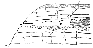
Fig. 42.—The Cefn Cave, in Vale of Clwyd. (Trimmer.) a, Entrance; b, mud with pebbles and wood covered with stalagmite; c, mud, bones, and angular fragments of limestone; d, sand and silt, with fragments of marine shells; e, fissure; f, northern drift; g, cave cleared of mud; h, river Elwy, 100 feet below; i, limestone rock.
“In the Vale of Clwyd an additional interest is imparted to the study of the drift from the circumstance that the remains of man have been found in deposits in caves sealed with drift-beds. The best example is the Cae Gwyn caves, in which flint implements and the bones and teeth of various extinct animals were found embedded in ‘cave-earth’ which was overlaid by bedded deposits of shell-bearing drift, with erratics of the northern type.
“It has been supposed that the drift-deposits were marine accumulations; but it is inconceivable that the cave could ever have been subjected to wave-action without the complete scouring out of its contents.
“To resume the delineation of the limits of the great Irish Sea Glacier: From the Vale of Clwyd the boundary runs along the range of hills parallel to the estuary of the Dee at an altitude of about nine hundred feet. As it is traced to the southeast it gradually rises, until at Frondeg, a few miles to the northward of the embouchure of the Yale of Llangollen, it is at a height of 1,450 feet above sea-level. Thence it falls to 1,150 feet at Gloppa, three miles to the westward of Oswestry, and this is the most southerly point to which it has been definitely traced on the Welsh border, though scattered boulders of northern rocks are known to occur at Church Stretton.
“Along the line from the Vale of Clwyd to Oswestry the boundary is marked by a very striking series of moraine-mounds. They occur on the extreme summits of lofty hills in a country generally almost driftless, and their appearance is so unusual that one—Moel-y-crio—at least has been mistaken for an artificial tumulus. The limitation of the dispersal of northern erratics by these mounds is very clear and sharp; and Mackintosh, in describing those at Frondeg, remarked that, while no northern rocks extended to the westward of them, so no Welsh erratics could be found to cross the line to the eastward. There are Welsh erratics in the low grounds of Cheshire and Shropshire, but their distribution is sporadic, and will be explained in a subsequent section.
“Having thus followed around the edges of this glacier, it remains to describe its termination. It is clear that the ice must have forced its way over the low water-shed between the respective basins of the Dee and the Severn. So soon as this ridge (less than 500 feet above the sea) is crossed, we find the deposits laid down by the glacier change their character, and sands and gravels attain a great predominance.[BO] Near Bridgenorth, and, at other places, hills composed of such materials attain an altitude of 200 feet. From Shrewsbury via Burton, and thence, in a semicircular sweep, through Bridgenorth and Enville, there is an immense concentration of boulders and pebbles, such as to justify the designation of a terminal moraine. To the southward, down the valley of the Severn, existing information points to the occurrence merely of such scattered pebbles as might have been carried down by floods. In the district lying outside this moraine there is a most interesting series of glacial deposits and of boulders of an entirely different character. (See map.)
“From the neighbourhood of Lichfield, through some of the suburbs of Birmingham, and over Frankley Hill and the Lickey Hills to Bromsgrove, there is a great accumulation of Welsh erratics, from the neighbourhood, probably, of Arenig Mawr.
“The late Professor Carvill Lewis suggested that these Arenig rocks might have been derived from some adjacent outcrop of Palæozoic rocks—a suggestion having its justification in the discoveries that had been made of Cumbrian rocks in the Midlands. To test the matter, an excavation was made at a point selected on Frankley Hill, and a genuine boulder-clay was found, containing erratics of the same type as those found upon the surface.
“The explanation has since been offered that this boulder-clay was a marine deposit laid down during a period of submerge nee.[BP] Apart from the difficulty that the boulder-clay displays none of the ordinary characteristics of a marine deposition, but possesses a structure, or rather absence of structure, in many respects quite inconsistent with such an origin, and contains no shells or other remains of marine creatures, it must be pointed out that no theory of marine notation will explain the distribution of the erratics, and especially their concentration in such numbers at a station sixty or seventy miles from their source.
“Upon the land-ice hypothesis this difficulty disappears. During the early stages of the Glacial period the Welsh ice had the whole of the Severn Valley at its mercy, and a great glacier was thrust down from Arenig, or some other point in central Wales, having an initial direction, broadly speaking, from west to east. This glacier extended across the valley of the Severn, sweeping past the Wrekin, whence it carried blocks of the very characteristic rocks to be lodged as boulders near Lichfield; and it probably formed its terminal moraine along the line indicated. (See lozenge-shaped marks on the map.) As the ice in the north gathered volume it produced the great Irish Sea Glacier, which pressed inland and down the Vale of Severn in the manner I have described, and brushed the relatively small Welsh stream out of its path, and laid down its own terminal moraine in the space between the Welsh border and the Lickey Hills. It seems probable that the Welsh stream came mainly down the Vale of Llangollen, and thence to the Lickey Hills. Boulders of Welsh rocks occur in the intervening tract by ones and twos, with occasional large clusters, the preservation of any more connected trail being rendered impossible by the great discharge of water from the front of the Irish Sea Glacier, and the distributing action of the glacier itself.
“Within the area in England and Wales covered by the Irish Sea Glacier all the phenomena point to the action of land-ice, with the inevitable concomitants of subglacial streams, extra-morainic lakes, etc. There is nothing to suggest marine conditions in any form except the occurrence of shells or shell fragments; and these present so many features of association, condition, and position inconsistent with, what we should be led to expect from a study of recent marine life, that conchologists are unanimous in declaring that not one single group of them is on the site whereon the shells lived. It is a most significant fact—one out of a hundred which could be cited did space permit—that in the ten thousand square miles of, as it is supposed, recently elevated sea-bottom, not a single example of a bivalve shell with its valves in apposition has ever been found! Nor has a boulder or other stone been found encrusted with those ubiquitous marine parasites, the barnacles.
“The evidences of the action of land-ice within the area are everywhere apparent in the constancy of direction of— (1.) Striæ upon rock surfaces. (2.) The terminal curvature of rocks. (3.) The ‘pull-over’ of soft rocks. (4.) The transportal of local boulders. (5.) The orientation of the long axes of large boulders. (6.) The false bedding of sands and gravels. (7.) The elongation of drift-hills. (8.) The relations of ‘crag and tail.’ There is a similar general constancy, too, in the directions of the striæ upon large boulders. Upon the under side they run longitudinally from southeast (or thereabouts) to northwest, while upon the upper surface they originate at the opposite end, showing that the scratches on the under side were produced by the stone being dragged from northwest to southeast, while those on the top were the product of the passage of stone-laden ice over it in the same direction.
“Such an agreement cannot be fortuitous, but must be attributed to the operation of some agent acting in close parallelism over the whole area. To attribute such regularity to the action of marine currents is to ignore the most elementary principles of marine hydrology. Icebergs must, in the nature of things, be the most erratic of all agents, for the direction of drift is determined—among other varying factors—by the draught of the berg. A mass of small draught will be carried by surface currents, while one of greater depth will be brought within the influence of under-currents; and hence it not infrequently happens that while floe-ice is drifting, say, to the southeast, giant bergs will go crashing through it to the northwest. There are tidal influences also to be reckoned with, and it is matter of common knowledge that flotsam and jetsam travel back and forth, as they are alternately affected by ebb and flood tide.
“Bearing these facts in mind, it is surely too much to expect that marine ice should transport boulders (how it picked up many of them also requires explanation) with such unfailing regularity that it can be said without challenge,[BQ] ‘boulders in this district [South Lancashire and Cheshire] never occur to the north or west of the parent rock.’ The same rule applies without a single authentic exception to the whole area covered by the eastern branch of the Irish Sea Glacier; and hence it comes about that not a single boulder of Welsh rock has ever been recorded from Lancashire.
“The Solway Glacier.—The pressure which forced much of the Irish Sea ice against the Cumbrian coast-line caused, as has been described, a cleavage of the flow near Ravenglass, and, having followed the southerly branch to its termination in the midlands, the remaining moiety demands attention.
“The ‘easting’ motion carried it up the Solway Frith, its right flank spreading over the low plain of northern Cumberland, which it strewed with boulders of the well-known ‘syenite’ (granophyre) of Buttermere. When this ice reached the foot of the Cross Fell escarpment, it suffered a second bifurcation, one branch pushing to the eastward up the valley of the Irthing and over into Tyneside, and the other turning nearly due southward and forcing its way up the broad Vale of Eden.
“Under the pressure of an enormous head of ice, this stream rose from sea-level, turned back or incorporated the native Cumbrian Glacier which stood in its path, and, having arrived almost at the water-shed between the northern and the southern drainage, it swept round to the eastward and crossed over the Pennine water-shed; not, however, by the lowest pass, which is only some 1,400 feet above sea-level, but by the higher pass of Stainmoor, at altitudes ranging from 1,800 to 2,000 feet. The lower part of the course of this ice-flow is sufficiently well characterised by boulders of the granite of the neighbourhood of Dalbeattie in Galloway; but on its way up the Vale of Eden it gathered several very remarkable rocks and posted them as way-stones to mark its course. One of these rocks, the Permian Brockram, occurs nowhere in situ at altitudes exceeding 700 feet, yet in the course of its short transit it was lifted about a thousand feet above its source. The Shap granite (see radiant point on map) is on the northern side of the east and west water-sheds of the Lake District, and reaches its extreme elevation, (1,656 feet) on Wasdale Pike; yet boulders of it were carried over Stainmoor, at an altitude of 1,800 feet literally by tens of thousands.