Front matter (continued 4)
Reading edition
“This Stainmoor Glacier passed directly over the Pennine chain, past the mouths of several valleys, and into Teesdale, which it descended and spread out in the low grounds beyond. Pursuing its easterly course, it abutted upon the lofty Cleveland Hills and separated into two streams, one of which went straight out to sea at Hartlepool, while the other turned to the southward and flowed down the Vale of York, being augmented on its way by tributary glaciers coming down Wensleydale. The final melting seems to have taken place somewhere a little to the southward of York; but boulders of Shap granite by which its extension is characterised have been found as far to the southward as Royston, near Barnsley.
“The other branch of the Solway Glacier—that which travelled due eastward—passed up the valley of the Irthing, and over into that of the Tyne, and out to sea at Tynemouth. It carried the Scottish granites with it, and tributary masses joined on either hand, bringing characteristic boulders with them.
“The fate of those elements of the Solway Frith Glacier which reached the sea is not left entirely to conjecture. The striated surfaces near the coast of Northumberland indicate a coastwise flow of ice from the northward—probably from the Frith of Forth—and the glaciers coming out from the Tyne and Tees were deflected to the southward.
“There is conclusive evidence that this ice rasped the cliffs of the Yorkshire coast and pressed up into some of the valleys. Where it passed the mouth of the Tees near Whitby it must have had a height of at least 800 feet, but farther down the coast it diminished in thickness. It nowhere extended inland more than a mile or two, and for the most part kept strictly to the coast-line. Along the whole coast are scattered erratics derived from Galloway and the places lying in the paths of the glaciers. In many places the cliffs exhibit signs of rough usage, the rocks being crumpled and distorted by the violent impact of the ice. At Filey Brigg a well-scratched surface has been discovered, the striation being from a few degrees east of north.
“At Speeton the evidence of ice-sheet or glacier-work is of the most striking character. On the top of the cliffs of Cretaceous strata a line of moraine-hills has been laid down, extending in wonderful perfection for a distance of six miles. They consist of a mixture of sand, gravel, and a species of clay-rubble, with occasional masses of true boulder-clay, the whole showing the arched bedding so characteristic of such accumulations. At the northerly end the moraine keeps close to the edge of the chalk cliffs, which are there 400 feet high, and the hills are frequently displayed in section; but as the elevation of the cliffs declines they fall back from the edge of the cliffs and run quite across the headland of Flamborough, and are again exposed in section in Bridlington Bay. One remarkable and significant fact is pointed out, namely, that behind this moraine, within half a mile and at a lower level, the country is almost absolutely devoid of any drift whatever.
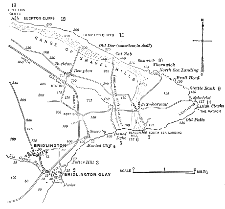
Fig. 43.—Moraine between Speeton and Flamborough (Lamplugh).
“The interpretation of these phenomena is as follows: When the valley-glaciers reached the sea they suffered the deflection which has been mentioned, partly as the result of the interference of ice from the east of Scotland, but also influenced directly by the cause which operated upon the Scottish ice and gave direction to it—that is, the impact of a great glacier from Scandinavia, which almost filled the North Sea, and turned in the eastward-flowing ice upon the British coast.
“It is easy to see how this pressure must have forced the glacier-ice against the Yorkshire coast, but vertical chalk cliffs 400 feet in height are not readily surmounted by ice of any thickness, however great, and so it coasted along and discharged its lateral moraine upon the cliff-tops. As the cliffs diminished in height we find the moraine farther inland, and, as I have pointed out, the ice completely overrode Flamborough Head. Amongst the boulders at Flamborough are many of Shap granite, a few Galloway granites, a profusion of Carboniferous rocks, brought by the Tyne branch of the Sol way Glacier as well as by that of Stainmoor, and, besides many torn from the cliffs of Yorkshire, a few examples of unquestionable Scandinavian rocks, such as the well-known Rhomben-porphyr. It is important to note that about ten to twenty miles from the Yorkshire coast there is a tract of sea-bottom called by trawlers ‘the rough ground,’ in allusion to the fact that it is strewn with large boulders, amongst which are many of Shap granite. This probably represents a moraine of the Teesdale Glacier, laid down at a time when the Scandinavian Glacier was not at its greatest development.
“On the south side of Flamborough Head the ‘buried cliff’ previously alluded to occurs. The configuration of the country shows—and the conclusion is established by numerous deep-borings—that the preglacial coast-line takes a great sweep inland from here, and that the plain of Holderness is the result of the banking-up of an immense thickness of glacial débris. In the whole country reviewed, from Tynemouth to Bridlington, wherever the ice came on to the land from the seaward, it brought in shells and fragmentary patches of the sea-bottom involved in its ground moraine. Space does not permit of a detailed description of the several members of the Yorkshire Drift, and I pass on to deal in a general way with the glacial phenomena of the eastern side of England.
“The East Anglian Glacier.—The influence of the Scandinavian ice is clearly seen in the fact that the entire ice-movement down the east coast south of Bridlington was all from the seaward. Clays, sands, and gravels, the products of a continuous mass of land-ice coming from the northeast are spread over the whole country, from the Trent to the high grounds on the north of London overlooking the Thames.
“The line of extreme extension of these drift-deposits runs from Finchley (near London), in the south across Hertfordshire, through Cambridgeshire, with outlying patches at Gogmagog and near Buckingham, and northwestward over a large portion of Leicestershire into the upper waters of the Trent, embracing the elevated region of Palæozoic rocks at Charnwood Forest, near Leicester.
“Reserving the consideration of the very involved questions connected with the drifts of the upper part of the Trent Valley, I may pass on to join the phenomena of the southeastern counties with those at Flamborough Head. From Nottinghamshire the limits of the drift of the East Anglian Glacier seem to run in a direction nearly due west to east, for the great oolitic escarpment upon which Lincoln Cathedral is built is absolutely driftless to the northward of the breach about Sleaford. However, along the western flank of the oolitic range true boulder-clay occurs, bordering and doubtless underlying the great fen-tract of mid-Lincolnshire; and the great Lincolnshire Wolds appear to have been completely whelmed beneath the ice.
“The most remarkable of the deposits in this area is the Great Chalky Boulder-Clay, which consists of clay containing much ground-up chalk, and literally packed with well-striated boulders of chalk of all sizes, from minute pebbles up to blocks a foot or more in diameter. Associated with them are boulders of various foreign rocks, and many flints in a remarkably fresh condition, and still retaining the characteristic white coat, except where partially removed by glacial attrition.
“One of the perplexing features of the glacial phenomena in the eastern counties of England is the extension of true chalky boulder-clay to the north London heights at Finchley and elsewhere; for only the faintest traces are to be found in the gravel deposits of the Thames Valley of any wash from such a deposit, or from a glacier carrying such materials.
“It has been suggested that the deposit may have been laid down in an extra-morainic lake, or in an extension of the North. Sea, but these suggestions leave the difficulty just where it was. If a lake or sea could exist without shores, a glacier-stream might equally dispense with banks. Within the area of glaciation, defined above, abundant evidence of the action of land-ice is obtainable, though striated surfaces are extremely rare—a fact attributable to the softness of the chalk and clays which occupy almost the whole area. Well-striated surfaces are found on the harder rocks, as, for example, on the oolitic limestone at Dunston, near Lincoln.
“Mr. Skertchly has remarked that the proofs of the action of land-ice are irrefragable. The Great Chalky Boulder-Clay covers an area of 3,000 square miles, and attains an altitude of 500 feet above the sea-level, thus bespeaking, if the product of icebergs, ‘an extensive gathering-ground of chalk, having an elevation of more than 500 feet. But where is it? Certainly not in Western Europe, for the chalk does not attain so great an elevation except in a few isolated spots.’[BR]
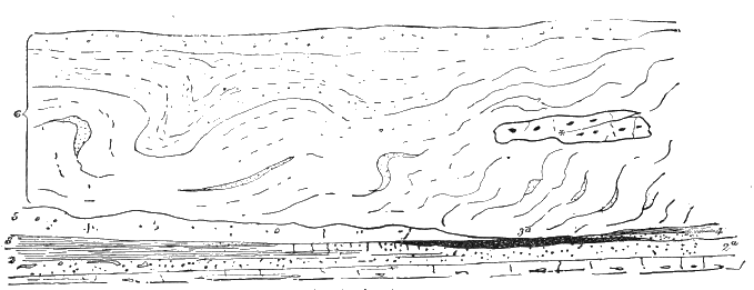
Fig. 44.—Diagram-section near Cromer (Woodward). 6. Gravel and sand (Middle Glacial) resting on contorted drift (loam, sand, and marl, with large included boulders of chalk); 5. Cromer till: 4. Laminated clay and sands (Leda myalis bed); 3. Fresh-water loams and sands: 3a. Black fresh-water bed of Runton (upper fresh-water bed); 2. Forest bed—laminated clays and sands, with roots and débris of wood, bones of mammalia, estuarine mollusca, etc., the upper part in places penetrated by rootlets (rootlet bed); 2a. Weybourn crag; 1. Chalk with flints; * Large included boulder of chalk.
“It has been further pointed out by Mr. Skertchly, that the condition of the flints in this deposit furnishes strong evidence that they could not have been carried by floating ice nor upon a glacier, for, in either of the latter events, there must have been some exposure to the weather, which, as he remarks, would have rendered them worthless to the makers of gun-flints, whereas they are now regularly collected for their use.
“The way in which the boulder-clay is related to the rocks upon which it rests is a conclusive condemnation of any theory of floating ice; for example, where it rests upon Oxford Clay, it contains the fossils characteristic of that formation, as it is largely made up of the clay itself. The exceptions to this rule are as suggestive as those cases which conform to it. Each outcrop yields material to the boulder-clay to the south westward, showing a pull-over from the northeast.
“One of the most remarkable features of the drift of this part of England is the inclusion of gigantic masses of rock transported for a short distance from their native outcrop, very often with so small a disturbance that they have been mapped as in situ. Examples of chalk-masses 800 feet in length, and of considerable breadth and thickness, have been observed in the cliffs near Cromer, in Norfolk, but they are by no means restricted to situations near the coast. One example is mentioned in which quarrying operations had been carried on for some years before any suspicion was aroused that it was merely an erratic. The huge boulders were probably dislodged from the parent rock by the thrust of a great glacier, which first crumbled the beds, then sheared off a prominent fold and carried it along. This explanation we owe to Mr. Clement Reid.[BS] The drift-deposits of this region frequently contain shells, but they rarely constitute what may be termed a consistent fauna, usually showing such an association as could only be found where some agent had been at work gathering together shells of different habitats and geological age.
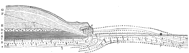
Fig. 45.—Section at right angles to the cliff through the westerly chalk bluff at Trimingham, Norfolk, showing the manner in which chalk masses are incorporated into the till (Clement Reid). Scale, 250 fret to an inch. A. Level of low-water spring-tides; B. Chalk, with sandy bed at *; C. Forest-bed series, etc., seen in the cliffs a few yards north and south of this point; D. Cromer till, stiff lead-colored boulder-clay; E. Fine, chalky sands, much false-bedded; F. Contorted drift, brown bouldery-clay with marked bedding- or fluxion-structure; G. The bed, above the white line were seen and measured by more snow and measured by Mr. Reid; * Chalk seen in situ on beach.
“If the ice-sheet, instead of flowing over the beds, happens to plough into them or abut against them, it would bend up a boss of chalk, as at Beeston. A more extensive disturbance, like that at Trimingham drives before it a long ridge of the bads, and nips up the chalk, till, like a cloth creased by the sliding of a heavy book, it is folded into an inverted anticlinal. A slight increase of pressure, and the third stage is reached—the top of the anticlinal being entirely sheared off, the chalk boulder driven up an incline, and forced into the overlying boulder-clays.” (Clement Reid.)
“Attempts have been made to correlate the deposits over the whole area, but with very indifferent success. A consideration of the consequences of the invasion of the country by an ice-stream from the northeast will prepare us for any conceivable complication of the deposits.
“The main movement was against the drainage of the country, so that the ice-front must have been frequently in water. There would be aqueous deposition and erosion; the kneading up of morainic matter into ground-moraine; irregularities of distribution and deposition due to ice floating in an extra-morainic lake; flood-washes at different points of overflow; and other confusing causes, which make it rather matter for surprise that any order whatever is traceable.
“I now turn to the valley of the Trent. We find that it occupies such a position that it would be exposed, successively or simultaneously, to the action of ice-streams of most diverse origin. I have shown that the area to the westward of Lichfield was invaded at one period by a Welsh glacier, and at a subsequent one by the Irish Sea Glacier, and both of these streams entered the valley of the Trent or some of its affluents. From the eastward, again, the great North Sea Glacier encroached in like manner, carrying the Great Chalky Boulder-Clay even into the drainage area of the westward-flowing rivers near Coventry.
“The glacial geology of the Trent Valley from Burton to Nottingham has been ably dealt with by Mr. R. M. Deeley,[BT] who recognises a succession which may be generalised as follows: (1.) A lower series containing rocks derived from the Pennine chain; (2.) A middle series containing rocks from the eastward (chalky boulder-clay, etc.); and (3.) An upper series with Pennine rocks. Mr. Deeley thinks the Pennine débris may have been brought by glaciers flowing down the valleys of the Dove, the Wye, and the Derwent; but, while recognising the importance of the testimony adduced, especially that of the boulders, I am compelled to reserve judgment upon this point until something like moraines or other evidences of local glaciers can be shown in those valleys. In their upper parts there is not a sign of glaciation. Some of the deposits described must have been laid down by land-ice; while the conformation of the country shows that during some stages of glaciation a lake must have existed into which the different elements of the converging glaciers must have projected. This condition will account for the remarkable commingling of boulders observed in some of the deposits. Welsh, Cumbrian, and Scottish rocks occur in the western portion of the Trent Valley. The overflow of the extra-morainic lake would find its way into the valleys of the Avon and Severn, and may be taken to account for the abundance of flints in some of the gravels.
“The Isle of Man.—This little island in mid-seas constituted in the early stages of the Glacial epoch an independent centre of glaciation, and from some of its valleys ice-streams undoubtedly descended to the sea; but with the growth of the great Irish Sea Glacier the native ice was merged in the invading mass, and at the climax of the period the whole island was completely buried, even to its highest peak (Snae Fell, 2,054 feet), beneath the ice. The effects of this general glaciation are clearly seen in the mantle of unstratified drift material which overspread the hills; in the moutonnée appearance of the entire island; and in the transport of boulders of local rocks. The striations upon rock surfaces show a constancy of direction in agreement with the boulder-transport which can be ascribed to no other agency than a great continuous sheet of such dimensions as to ignore minor hills and valleys.
“The disposition of the striæ is equally conclusive, for we find that on a stepped escarpment of limestone both the horizontal and the vertical faces are striated continuously and obliquely from the one on to the other, showing that the ice had a power of accommodating itself to the surface over which it passed that could not be displayed by floating ice. There is a remarkable fact concerning the distribution of boulders on this island which would strike the most superficial observers, namely, that foreign rocks are confined to the low grounds. It might be argued that the local ice always retained its individuality, and so kept the foreign ice with its characteristic boulders at bay. But, apart from the a priori improbability of so small a hill-cluster achieving what the Lake District could not accomplish, the fact that Snae Fell, an isolated conical hill, is swathed in drift from top to bottom, is quite conclusive that the foreign ice must have got in. Why, then, did it carry no stones with it? The following suggestion I make not without misgivings, though there are many facts to which I might appeal that seem strongly corroborative:
“The hilly axis of the island runs in a general northeast and southwest direction, and it rises from a great expanse of drift in the north with singular abruptness, some of the hills being almost inaccessible to a direct approach without actual climbing. I imagine that the ice which bore down upon the northern end of the island was, so far as its lower strata were concerned, unable to ascend so steep an acclivity, and was cleft, and flowed to right and left. The upper ice, being of ice-sheet origin, would be relatively clean, and this flowing straight over the top of the obstruction would glaciate the country with such material as was lying loose upon the ground or could be dislodged by mere pressure. It would appear from published descriptions that the Isle of Arran offers the same problem, and I would suggest the application of the same solution to it.
“Marine shells occur in the Manx drift, but only in such situations as were reached by the ice-laden with foreign stones. They present similar features of association of shells of different habitat, and perhaps of geological age, to those already referred to as being common characteristics of the shell-faunas of the drift of the mainland. Four extinct species of mollusca have been recognised by me in the Manx drift.
“The Manx drift is of great interest as showing, perhaps better than any locality yet studied, those features of the distribution of boulders of native rocks which attest so clearly the exclusive action of land-ice. There are in the island many highly characteristic igneous rocks, and I have found that boulders of these rocks never occur to the northward of the parent mass, and very rarely in any direction except to the southwest.
“Cumming observed in regard to one rock, the Foxdale granite, that whereas the highest point at which it occurs in situ was 657 feet above sea-level, boulders of it occurred in profusion within 200 feet of the summit of South Barrule (1,585 feet), a hill two miles only, in a southwesterly direction, from the granite outcrop.
“They also occur on the summit of Cronk-na-Irrey-Lhaa, 1,449 feet above sea-level. The vertical uplift has been 728 and 792 feet respectively.
“In the low grounds of the north of the island a finely developed terminal moraine extends in a great sweep so as to obstruct the drainage and convert thousands of acres of land into lake and morass, which is only now yielding to artificial drainage. Many fine examples of drumlin and esker mounds occur at low levels in different parts of the island; and it was remarked nearly fifty years ago by Cumming, that their long axes were parallel to the direction of ice-movement indicated by the striated surfaces and the transport of boulders.
“The foreign boulders are mainly from the granite mountains of Galloway, but there are many flints, presumably from Antrim, a very small number of Lake District rocks, and a remarkable rock containing the excessively rare variety of hornblende, Riebeckite. This has now been identified with a rock on Ailsa Crag, a tiny islet in the Frith of Clyde; and a Manx geologist, the Rev. S. N. Harrison, has discovered a single boulder of the highly characteristic pitchstone of Corriegills, in the Isle of Arran.
“The So-called Great Submergence.
“It may be convenient to adduce some additional facts which render the theory of a great submergence of the country south of the Cheviots untenable.
“The sole evidence upon which it rests is the occurrence of shells, mostly in an extremely fragmentary condition, in deposits occurring at various levels up to about 1,400 feet above sea-level: A little space may profitably be devoted to a criticism of this evidence.
“Moel Tryfaen (‘The Hill of the Three Rocks’).—This celebrated locality is on the first rise of the ground between the Menai Straits and the congeries of hills constituting ‘Snowdonia’; and when we look to the northward from the top of the hill (1,350 feet) we see the ground rising from the straits in a series of gentle undulations whose smooth contours would be found from a walk across the country to be due to the thick mask of glacial deposits which obliterates the harsher features of the solid rocks.
“The deposits on Moel Tryfaen are exposed in a slate-quarry on the northern aspect of the hill near the summit, and consist of two wedges of structureless boulder-clay, each thinning towards the top of the hill. The lower mass of clay, wherever it rests upon the rock, contains streaks and irregular patches of eccentric form, of sharp, perfectly angular fragments of slate; and the underlying rock may be seen to be crushed and broken, its cleavage-laminæ being thrust over from northwest to southeast—that is, up-hill. The famous ‘shell-bed’ is a thick series of sands and gravels interosculated with the clays on the slope of the hill, but occupying the entire section above the slate towards the top. The bedding shows unmistakable signs of the action of water, both regular stratification and false bedding being well displayed. The stones occurring in the clays are mainly if not entirely Welsh, including some from the interior of the country, and they are not infrequently of large size—two or three tons’ weight—and well scratched.
“The stones found in the sands and gravels include a great majority of local rocks, but besides these there have been recorded the following:
Rock. Source. Highest point in situ. Minimum uplift in feet.
Granite Eskdale, Cumberland 1,286 64
Granite Criffel, Galloway ..... ...
Flint Antrim (?) 1,000 350
To these I can add:
Granophyre Buttermere, Cumberland ..... ...
Eurite [BU] Ailsa Craig, Frith of Clyde 1,097 253
“The shells in the Moel Tryfaen deposit have been fully described, so far as the enumeration of species and relative frequency are concerned, but little has been said as to their absolute abundance and their condition. The shells are extremely rare, and daring a recent visit a party of five persons, in an assiduous search of about two hours, succeeded in finding five whole shells and about two ounces of fragments. The opportunities for collecting are as good as could be desired. The sections exposed have an aggregate length of about a quarter of a mile, with a height varying from ten to twenty feet of the shelly portion; and besides this there are immense spoil-banks, upon whose rain-washed slopes fossil-collecting can be carried on under the most favorable conditions.
“I would here remark, that the occurrence of small seams of shelly material of exceptional richness has impressed collectors with the idea that they were dealing with a veritable shell-bed, when the facts would bear a very different interpretation. A fictitious abundance is brought about by a process of what may be termed ‘concentration,’ by the action of a gently flowing current of water upon materials of different sizes and different specific gravities. Shells when but recently vacated consist of materials of rather high specific gravity, penetrated by pores containing animal matter, so that the density of the whole mass is far below that of rocks in general, and hence a current too feeble to move pebbles would yet carry shells. Illustrations of this process may be observed upon any shore in the concentration of fragments of coal, corks, or other light material.
“Regarding the interpretation of these facts: The commonly received idea is, that the beds were laid down in the sea during a period of submergence, and that the shells lived, not perhaps on the spot, but somewhere near, and that the terminal curvature of the slate was produced by the grounding of icebergs which also brought the boulders. But if this hypothesis were accepted, it would be necessary to invest the flotation of ice with a constancy of direction entirely at variance with observed facts, for the phenomena of terminal curvature is shown" with perfect persistence of direction wherever the boulder-clay rests upon the rock; and, further, there is the highly significant fact, that neither the sands and gravels nor the rock upon which they rest show any signs of disturbance or contortion, such as must have been produced if floating ice had been an operative agent.
“The uplift of foreign rocks is equally significant; and when we take into account the great distances from which they have been borne and the frequency with which such an operation must have been repeated, the inadequacy becomes apparent of Darwin’s ingenious suggestion, that it might have been effected by a succession of uplifts by shore-ice during a period of slow subsidence; while the character and abundance of the molluscan remains invest with a species of irony the application of the term ‘shell-bed’ to the deposit.
“I now turn to the alternative explanation (see ante, p. 145), viz., that the whole of the phenomena were produced by a mass of land-ice which was forced in upon Moel Tryfaen from the north or northwest, overpowering any Welsh ice which obstructed its course. This view is in harmony with the observations regarding the ‘terminal curvature’ of the slates, the occurrence of sharp angular chips of slate in the boulder-clay, and the coincidence of direction of these indications of movement with the carry of foreign stones. The few shells and shell-crumbs in the sands and gravels would, upon this hypothesis, be the infinitesimal relics of huge shell-banks in the Irish Sea which were destroyed by the glacier and in part incorporated in its ground-moraine or involved in the ice itself. The sands and gravels would represent the wash which would take place wherever, by the occurrence of a ‘nunatak’ or by approach to the edge of the ice, water could have a free escape.
“Two principal objections have been urged to the land-ice explanation of the Moel Tryfaen deposits. An able critic asks, ‘Can, then, ice walk up-hill?’ To this we answer, Given a sufficient ‘head’ behind it, and ice can certainly achieve that feat, as every roche moutonnée proves. If it be granted that ice on the small scale can move up-hill, there is no logical halting-place between the uplift of ten or twenty feet to surmount a roche moutonnée, and an equally gradual elevation to the height of Moel Tryfaen. Furthermore, the inland ice of Greenland is known to extrude its ground-moraine on the ‘weather-side’ of the nunataks, and the same action would account for the material uplifted on Moel Tryfaen.
“The second objection brought forward was couched in somewhat these terms: ‘If the Lake District had its ice-sheet, surely Wales had one also. Could not Snowdonia protect the heart of its own domain?’ Of course, Wales had its ice-sheet, and the question so pointedly raised by the objector needs an answer; and though it is merely a question of how much force is requisite to overcome a certain resistance (both factors being unknown), still there are features in the case which render it specially interesting and at the same time comparatively easy of explanation. It seems rather like stating a paradox, yet the fact is, that it was the proximity of Snowdon which, in my opinion, enabled the foreign ice to invade Wales at that point.
“A glance at the map will show that the ‘radiant point’ of the Welsh ice was situated on or near Arenig Mawr, and that the great mass of Snowdon stands quite on the periphery of the mountainous regions of North Wales, so that it would oppose its bulk to fend off the native ice-sheet and prevent it from extending seaward in that direction.

Fig. 46.—Section across Wales to show the relationship of native to foreign ice.
“As a consequence, the only Welsh ice in position to obstruct the onward march of the invader would be such trifling valley-glaciers as could form on the western slopes of Snowdon itself.
“The peak of Snowdon is 3,570 feet above sea-level, and Arenig Mawr, 2,817 feet high, is eighteen miles to the eastward, and a broad, deep valley with unobstructed access to Cardigan Bay intervenes; so, if any ice from the central mass made its way over the Snowdonian range, it performed a much more surprising feat than that involved in the ascent of Moel Tryfaen from the westward.
“The profile shows in diagrammatic form the probable relations of the foreign to the native ice at the time when the Moel Tryfaen deposits were laid down.
“From what has been said regarding the great glaciers, it would seem that ice advanced upon the land from the seaward in several parts of the coast of England, Wales, and the Isle of Man. Now, it is in precisely those parts of the country, and those alone, that the remains of marine animals occur in the glacial deposits. If the dispersal of the shells found in the drift had been effected by the means I have suggested, it would follow, as an inevitable consequence, that wherever shells occur there should also be boulders which have been brought from beyond the sea. This I find to be the case, and in two instances the discovery of shells was preliminary to the extension of the boundaries of the known distribution of boulders of trans-marine origin.
“The officers of the Geological Survey some years ago observed the occurrence of ‘obscure fragments of marine shells’ in a deposit at Whalley, Lancashire, in which they could find only local rocks. One case such as this would be fatal to the theory of the remanié origin of the shells, but on visiting the section with Mr. W. A. Downham, I found, amongst the very few stones which occurred in the shell-bearing sand at the spot indicated, two well-marked examples of Cumbrian volcanic rocks, and, at a little distance, large boulders of Scottish granites.
“The second case is more striking. The announcement was made that shells had been found on a hill called Gloppa near Oswestry, in Shropshire, and, as it lay about five miles to the westward of Mackintosh’s boundary of the Irish Sea Glacier, and therefore well within the area of exclusively Welsh boulders, it furnished an excellent opportunity of putting the theory to the test. An examination of the boulders associated with the shells showed that the whole suite of Galloway and Cumbrian erratics such as belong to the Irish Sea Glacier were present in great abundance. Not only this, but in the midst of the series of shell-bearing gravels I observed a thin lenticular bed of greenish clay, which upon examination was found to be crowded with well-scratched specimens of Welsh rocks; but neither a morsel of shell nor a single pebble of a foreign rock could be found, either by a careful examination in the field or by washing the clay at home, and examining with a lens the sand and stones separated out.
“The fact that predictions such as these have been verified affords a very striking corroboration of the theory put forward; and, though shells cannot be found in every deposit in which they might, ex hypothesi, be found, yet the strict limitation of them to situations which conform to those assigned upon theoretical grounds cannot be ascribed to mere coincidence. If the land had ever been submerged during any part of the Glacial epoch to a depth of 1,400 feet, it is inconceivable that clear and indisputable evidence should not be found in abundance in the sheltered valleys of the Lake District and Wales, which would have been deep, quiet fiords, in which vast colonies of marine creatures would have found harbour, as they do in the deep lochs of Scotland to-day.
“It has been urged, in explanation of this absence of marine remains in the great hill-centres, that the ‘second glaciation’ might have destroyed them; but to do this would require that the ice should make a clean and complete sweep of all the loose deposits both in the hollows of the valleys and on the hill-sides, and further that it should destroy all the shells and all the foreign stones which floated in during the submergence. At the same time we should have to suppose that the drift which lay in the paths of the great glaciers was not subjected to any interference whatever. But, assuming that these difficulties were explained, there would still remain the fact that the valleys which have never been glaciated—as, for example, those of Derbyshire—show no signs whatever of any marine deposits, nor of marine action in any form whatever.
“The sea leaves other traces also, besides shells, of its presence in districts that have really been submerged, yet there are no signs whatever to be found of them in all England, except the post-glacial raised beaches. Furthermore, in all the area occupied by glacial deposits there are no true sea-beaches, no cliffs nor sea-worn caves, no barnacle-encrusted rocks, nor rocks bored by Pholas or Saxicava. Are we to believe that these never existed; or that, having existed, they have been obliterated by subsequent denudations? To make good the former proposition, it would be necessary as a preliminary to show that the movement of subsidence and re-elevation was so rapid, and the interval between so brief, that no time was allowed for any marine erosion to take place. If this were so, it would be the most stupendous catastrophe of which we have any geological record; but we are not left in doubt regarding the duration of the submerged condition, for the occurrence of forty feet of gravel upon the summits of the hills indicates plainly that, if they were accumulated by the sea, the land must have stood at that level for a very long period, amply sufficient for the formation of a well-marked coast-line.
“The alternative proposition, that post-glacial denudation had removed the traces of subsidence, is equally at variance with the evidence. Post-glacial denudation has left kames and drumlins, and all the other forms of glacial deposits, in almost perfect integrity; the small kettle-holes are not yet filled up; and it is therefore quite out of the question that the far more enduring features, such as sea-cliffs, shore platforms, and beaches, should have been destroyed.
“The only reasonable conclusion is, that these evidences of marine action never existed, because the land in glacial times was never depressed below its present level. If the level were different at all (as I think may have been the case on the western side of England), it was higher, and not lower.
“The details of the submergence hypothesis have, so far as I am aware, never been dealt with by its advocates, otherwise I cannot but think that it would have been abandoned long since. It has been stated in general terms that the subsidence was greatest in the north and diminished to zero in the south, but no attempt was made to trace the evidence of extreme subsidence across country and along the principal hill-ranges—in fact, to see how it varied in every direction.
“If we take a traverse of England, say from Flamborough Head upon the east to Moel Tryfaen on the west, and accept as evidence of submergence any true glacial deposits (except, as in the case of the interior of Wales, the deposits are obviously the effects of purely local glaciers and contain, therefore, no shells), we shall find that the subsidence, if any, must have been not simply differential but sporadic.
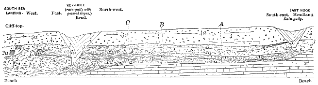
Fig. 47.—Section of the cliff on the east side of South Sea Landing, Flamborough Head. Scale, 120 feet to 1 inch; length of section 290 yards; average height, 125 feet. (See above map of moraine between Speeton and Flamborough.) Explanation.—4. Brownish boulder-clay, a band of pebbles; 4a, in places about seven feet from top. 3. Washed gravel, with thin sand-seams, well-bedded, pebbles chiefly erratics. 2. “Basement” boulder-clay, with many included patches of sand, gravel, and silt; 2a, at B, one of these 2b contain shells. 1b. Sand and silt, overlying and in places interbedded with 1. 1. Rubble of angular and subangular chalk-blocks and gravel, with occasional erratic, passes partly into chalky boulder-clay, 1a. x. White chalk, without flints, surface much shaken.
“At Flamborough Head shelly drift attains an altitude of 400 feet, but half a mile from the coast the country is practically driftless even at lower levels. The Yorkshire Wolds were not submerged. On the western flanks of the wolds drift comes in at about 100 to 150 feet, and persists, probably, under the post-glacial warp, from which it again protrudes on the western side of the valley of the Ouse, and however the drift between there and the Pennine water-shed may be interpreted, it shows not a sign of marine origin; but, even granting that it did, we find that it does not reach within a thousand feet of the water-shed. When the water-shed is crossed, however, abundant glacial deposits are met with which are not to be differentiated from others at slightly lower levels which contain shells.
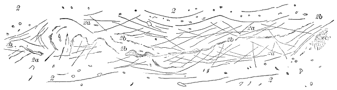
Fig. 48.—Enlarged section of the shelly sand and surrounding clay at B in preceding figure. Scale, 4 feet to 1 inch. Explanation.—2. “Basement” boulder-clay. 2a. Pure compact blue and brown clay of aqueous origin, bedding contorted and nearly obliterated, but the mass is cut up by shearing planes. 2b. Irregular seam, and scattered streaks, of greenish-yellow sand with many marine shells. 2c. Patch of pale-yellow sand, different from 2b, without trace of fossils.
“If we suppose that the line of our traverse crosses the Pennine Chain at Heald Moor, we shall find that on the eastern side no traces of drift occur above about 300 feet; while the very summit of the water-shed is occupied by boulder-clay, and thence downward the trace is practically continuous, and at about 1,000 feet and downward the drift contains marine shells. Across the great plain of Lancashire and Cheshire the ‘marine’ drift is fully developed—though it may be remarked in parentheses that it contains a shallow-water fauna, albeit ex hypothesi deposited, in part at least, in a depth of 200 fathoms of water—and to the Welsh border at Frondeg, where it again reaches a water-shed at an altitude of 1,450 feet; but at 100 yards to the westward of the summit all traces of subsidence disappear, and through the centre of Wales no sign is visible; then we emerge on the western slopes at Moel Tryfaen, and they assume their fullest dimensions, though only to finish abruptly on the hill-top, and put in no appearance in the lower grounds which extend from there to the sea.
“The conclusions pointed to by the evidence (and, as I have endeavoured to show, all the evidence which existed at the close of the Glacial period is there still) are, that a subsidence of the Yorkshire Wolds took place on the east, but not in the centre or west; that the Pennine Chain was submerged on the western side to a depth of 1,400 feet, and on the east to not more than 300 feet, even on opposite sides of the same individual hill; that all the lowlands between, say, Bacup and the Welsh border, were submerged, and that the hills near Frondeg partook of this movement, but only on their eastern sides; that the centre of Wales was exempt, but that the summit of Moel Tryfaen forms an isolated spot submerged, while the surrounding country escaped. These absurdities might be indefinitely multiplied, and they must follow unless it be admitted that the phenomena are the results of glacial ice, and that ice can move ‘up-hill.’
“The south of England certainly has partaken of no movement of subsidence. A line drawn from Bristol to London will leave all the true glacial deposits to the northward, except a bed of very questionable boulder-clay at Watchet, and a peculiar deposit of clayey rubble which has been produced on the flanks of the Cornish hills probably, as the late S. V. Wood, Jr, suggested, by the slipping of material over a permanently frozen subsoil.
“For the remainder of the southern area the evidence is plain that there has been no considerable subsidence during glacial times. The presence over large areas of chalk country of the ‘clay with flints’—a deposit produced by the gradual solution of the chalk and the accumulation in situ of its insoluble residue—is absolute demonstration that for immense periods of time the country has been exempt from any considerable aqueous action. The enormous accumulations of china clay upon the granite bosses of Cornwall and Devon tell the same tale. A few erratics have been found at low levels at various points on the southern coasts, usually not above the reach of the waves. These consist of rocks which may have been floated by shore-ice from the Channel Islands or the French coast.
“This imperfect survey of the evidence against the supposed submergence has been rendered the more difficult by the fact that it is not considered necessary to produce the evidence of marine shells in all cases. Indeed, it has been argued that post-Tertiary beds covering thousands of square miles might be absolutely destitute of shells without prejudice to the theory of their formation in the sea.
“But such a suggestion, one would think, could hardly come from anyone familiar with marine Tertiary deposits, or even with the appearance of modern sea-beaches. Admitting, however, for the purposes of argument, that the beaches along a great extent of coast might be devoid of shells, it cannot be argued that the deep waters were destitute of life; and hence the boulder-clays, if of marine origin, should contain a great abundance of shells and other remains, and, once entombed, it is beyond belief that they could all be removed from such a deposit in the short lapse of post-glacial time.
“Now, some of the boulder-clays—as, for example, those of Lancashire and Cheshire—are held to be of marine origin, and this is indeed a vital necessity to the submergence theory; for, if these are not marine deposits, neither are the other shelly deposits; but these boulder-clays are absolutely indistinguishable from those lying within the hill-centres, and, as it passes belief that such deposits could be of diverse origin and yet possess an identical structure and arrangement, then we should have a right to demand that these clays should have enclosed shells and should still contain them, but they do not.
“I may here mention that I am informed by Mr. W. Shone, F. G. S.—and he was good enough to permit me to quote the statement—that the boulder-clay of Cheshire and the shelly boulder-clay of Caithness are ‘as like as two peas.’ The importance of this comparison lies in the fact that, since Croll’s classical description, all observers have agreed that it was the product of land-ice which moved in upon the land out of the Dornoch Firth. It was pointed out then, as since has been done for England, that it was only where the direction of ice-movement was from the seaward that any shells occur in the boulder-clay.
“The Dispersion of Erratics of Shap Granite.—So great a significance attaches to the peculiar distribution of this remarkable rock, that I may add a few details here which could not be conveniently introduced elsewhere.
“This granite occupies an area which lies just to the northward of the water-shed between the basins of the Lime and the Eden, and its extreme elevation is 1,656 feet. Boulders occur in large numbers as far to the northward as Cross Fells, while, as already described, they pass over Stainmoor and are dispersed in great numbers along the route taken by the great Stainmoor branch of the Solway Glacier. But a considerable number of the boulders also found their way to the southward, and a well-marked trail can be followed down into Morecambe Bay; and at Hest Bank, to the north of Lancaster, the boulder-clay contains many examples, together with the ‘mica-trap’ of the Kendal and Sedbergh dykes and other local rocks, but no shells or erratics from other sources than the country draining into Morecambe Bay. To the southward the ice which bore these rocks was deflected by the great Irish Sea Glacier, and, so far as present information enables me to state, the Shap granite blocks mark the course of the medial moraine between these two ice-streams. It has been found near Garstang, at Longridge, and at Whalley, this being the exact line of junction of the Irish Sea Glacier with the ice from Morecambe Bay and the Pennine Chain.
“It is a very remarkable and significant fact, that not a single authentic occurrence of the rock across the boundary indicated has yet been recorded.”
Northern Europe.
On passing over the shallow German Sea from England to the Continent, the southern border of the Scandinavian ice-field is found south of the Zuyder Zee, between Utrecht and Arnhem—the moraine hills in the vicinity of Arnhem being quite marked, and a barren, sandy plain dotted with boulders and irregular moraine hills extending most of the way to the Zuyder Zee. From Arnhem the southern boundary of the great ice-field runs “eastward across the Rhine Valley, along the base of the Westphalian Hills, around the projecting promontory of the Hartz, and then southward through Saxony to the roots of the Erzgebirge. Passing next southeastward along the flanks of the Riesen and Sudeten chain, it sweeps across Poland into Russia, circling round by Kiev, and northward by Nijni-Novgorod towards the Urals.”[BV] Thence the boundary passes northward to the Arctic Ocean, a little east of the White Sea.
The depth of this northern ice-sheet is proved to have been upwards of 1,400 feet where it met the Hartz Mountains, for it has deposited northern débris upon them to that height; while, as already shown, it must have been over 2,000 feet in the main valley of Switzerland. In Norway it is estimated that the ice was between 6,000 and 7,000 feet thick.
The amount of work done by the continental glaciers of Europe in the erosion, transportation, and deposition of rock and earthy material is immense. According to Helland, the average depth of the glacial deposits over North Germany and northwestern Russia is 150 German feet, i. e., about 135 English feet. As the deposition towards the margin of a glacier must be commensurate with its erosion near the centre of movement, this vast amount implies a still greater proportionate waste in the mountains of Scandinavia, where the area diminishes with every contraction of the circle. Two hundred and fifty feet is therefore not an extravagant calculation for the amount of glacial erosion in the Scandinavian Peninsula.
It is not difficult to see how the Scandinavian mountains were able to contribute so much soil to the plains of northern Germany and northwestern Russia. Previous to the Glacial period, a warm climate extended so far north as to permit the growth of semi-tropical vegetation in Spitsbergen, Greenland, and the northern shores of British America. Such a climate, with its abundant moisture and vegetation, afforded most favourable conditions for the superficial disintegration of the rocks. When, therefore, the cold of the Glacial period came on, the moving currents of ice would have a comparatively easy task in stripping the mantle of soil from the hills of Norway and Sweden, and transporting it towards the periphery of its movement. Of course, erosion in Scandinavia meant subglacial deposition beyond the Baltic. Doubtless, therefore, the plains of northern Germany, with their great depth of soil, are true glacial deposits, whose inequalities of surface have since been much obliterated, through the general influences of the lapse of time, and by the ceaseless activity of man.
An interesting series of moraines in the north of Germany, bordering the Baltic Sea, was discovered in 1888 by Professor Salisbury, of the United States Geological Survey. Its course lies through Schleswig-Holstein, Mecklenburg, Potsdam (about forty miles north of Berlin), thence swinging more to the north, and following nearly the line between Pomerania and West Prussia, crossing the Vistula about twenty miles south of Dantzic, thence easterly to the Spirding See, near the boundary of Poland.
Among the places where this moraine can be best seen are—“1. In Province Holstein, the region about (especially north of) Eutin; 2. Province Mecklenburg, north of Crivitz, and between Bütow and Kröpelin; 3. Province Brandenburg, south of Reckatel, between Strassen and Bärenbusch, south of Fürstenberg and north of Everswalde, and between Pyritz and Solden; 4. Province Posen, east of Locknitz, and at numerous points to the south, and especially about Falkenburg, and between Lompelburg and Bärwalde. This is one of the best localities. 5. Province West Preussen, east of Bütow; 6. Province Ost Preussen, between Horn and Widikin.”
Comparing these with the moraines of America, Professor Salisbury remarks:
“In its composition from several members, in its variety of development, in its topographic relations, in its topography, in its constitution, in its associated deposits, and in its wide separation from the outermost drift limit, this morainic belt corresponds to the extensive morainic belt of America, which extends from Dakota to the Atlantic Ocean. That the one formation corresponds to the other does not admit of doubt. In all essential characteristics they are identical in character. What may be their relations in time remains to be determined.”
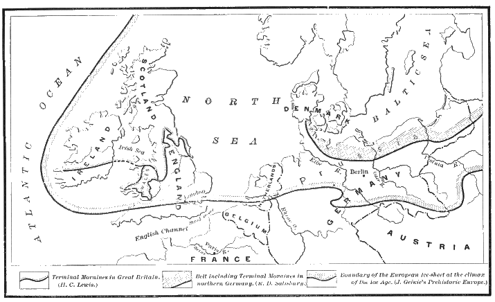
Fig. 49.—Map showing the glaciated area of Europe according to J. Geikie, and the moraines in Britain and Germany according to Lewis and Salisbury.
The physical geography of Europe is so different from that of America, that there was a marked difference in the secondary or incidental effects of the Glacial period upon the two regions. In America the continental area over which the glaciers spread is comparatively simple in its outlines. East of the Rocky Mountains, as we have seen, the drainage of the Glacial period was, for a time, nearly all concentrated in the Mississippi basin, and the streams had a free course southward.
But in Europe there was no free drainage to the south, except over a small portion of the glaciated area in central Russia, about the head-waters of the Dnieper, the Don, and the Volga; though the Danube and the Rhône afforded free course for the waters of a portion of the great Alpine glaciers. But all the great rivers of northern Europe flow to the northward, and, with the exception of the Seine, they all for a time encountered the front of the continental ice-sheet. This circumstance makes it difficult to distinguish closely between the direct glacial deposits in Europe and those which are more or less modified by water-action. At first sight it would seem also somewhat hazardous to attempt to correlate with any portion of the Glacial period the deposition of the gravelly and loamy deposits in valleys, which, like those of the Seine and Somme, lie entirely outside of the glaciated area.
Upon close examination, however, the elements of doubt more and more disappear. The Glacial period was one of great precipitation, and it is natural to suppose that the area of excessive snow-fall extended considerably beyond the limit of the ice-front. During that period therefore, the rivers of central France must have been annually flooded to an extent far beyond anything which is known at the present time. Since these rivers flowed to the northward, at a period when, during the long and severe winters, the annual accumulation of ice near their mouths was excessive, ice-gorges of immense extent, such as now form about the mouths of the Siberian rivers, would regularly occur. We are not surprised, therefore, to find, even in these streams, abundant indications of the indirect influence of the great northern ice-sheet.
The indications referred to consist of high-level gravel terraces occasionally containing boulders, of from four to five tons weight, which have been transported for a considerable distance. The elevation of the terraces above the present flood-plains of the Seine and Somme reaches from 100 to 150 feet. We are not to suppose, however, that even in glacial times the floods of the river Seine could have filled its present valley to that height. The highest flood in this river known in historic times rose only to a height of twenty-nine feet. Mr. Prestwich estimates that, without taking into consideration the more rapid discharge, a flood of sixty times this magnitude would be required to fill the present valley to the level of the ancient gravels, while at Amiens the shape of the valley of the Somme is such that five hundred times the mean average of the stream would be required to reach the high-level gravels. The conclusion, therefore, is that the troughs of these streams have been largely formed by erosion since the deposition of the high-level gravels.
Connected with these terrace gravels in northern France is a loamy deposit, corresponding to the loess in other parts of Europe, and to a similar deposit to which we have referred in describing the southwestern part of the glaciated area in North America. In northern France this fine silt overlies the high-level gravel deposits, and, as Mr. Prestwich has pretty clearly shown, was deposited contemporaneously with them during the early inundations and before the stream had eroded its channel to its present level.
The distribution of loess in Europe was doubtless connected with the peculiar glacial conditions of the continent. Its typical development is in the valley of the Rhine, where it is described by Professor James Geikie “as a yellow or pale greyish-brown, fine-grained, and more or less homogeneous, consistent, non-plastic loam, consisting of an intimate admixture of clay and carbonate of lime. It is frequently minutely perforated by long, vertical, root-like tubes which are lined with carbonate of lime—a structure which imparts to the loess a strong tendency to cleave or divide in vertical planes. Thus it usually presents upright bluffs or cliffs upon the margins of streams and rivers which intersect it. Very often it contains concretions or nodules of irregular form.... Land-shells and the remains of land animals are the most common fossils of the loess, but occasionally fresh-water shells and the bones of fresh-water fish occur.”
“From the margins of the modern alluvial flats which form the bottoms of the valleys it rises to a height of 200 or 300 feet above the streams—sweeping up the slopes of the valleys, and imparting a rich productiveness to many districts which would otherwise be comparatively unfruitful. From the Rhienthal itself it extends into all the tributary valleys—those of the Neckar, the Main, the Lahn, the Moselle, and the Meuse, being more or less abundantly charged with it. It spreads, in short, like a great winding-sheet over the country—lying thickly in the valleys and dying off upon the higher slopes and plateaux. Wide and deep accumulations appear likewise in the Rhône Valley, as also in several other river-valleys of France, as in those of the Seine, the Saône, and the Garonne, and the same is the case with many of the valleys of middle Germany, such as those of the Fulda, the Werra, the Weser, and the upper reaches of the great basin of the Elbe. It must not be supposed that the loess is restricted to valleys and depressions in the surface of the ground.
“It is true that it attains in these its greatest thickness, but extensive accumulations may often be followed far into the intermediate hilly districts and over the neighbouring plateaux. Thus the Odenwald, the Taunus, the Vogelgebirge, and other upland tracts, are cloaked with loess up to a considerable height. Crossing into the drainage system of the Danube, we find that this large river and many of its tributaries flow through vast tracts of loess. Lower Bavaria is thickly coated with it, and it attains a great development in Bohemia, Upper and Lower Austria, and Moravia—in the latter country rising to an elevation of 1,300 feet. It is equally abundant in Hungary, Galicia, Bukowina, and Transylvania. From the Danubian flat lands and the low grounds of Galicia it stretches into the valleys of the Carpathians, up to heights of 800 and 2,000 feet. In some cases it goes even higher—namely, to 3,000 feet, according to Zeuschner, and to 4,000 or 5,000 feet, according to Korzistka. These last great elevations, it will be understood, are in the upper valleys of the northern Carpathians. In Roumania loess is likewise plentiful, but it has not been observed south of the Balkans. East of the Carpathians—that is to say, in the regions watered by the Dniester, the Dnieper, and the Don—loess appears also to be wanting, and to be represented by those great steppe-deposits which are known as Tchernozen, or black earth.”[BW]
The shells found in the loess indicate both a colder and a wetter climate during its deposition than that which now exists. The relics of land animals are infrequently found in the deposit, yet they do occur, but mostly in fragmentary condition—the principal animals represented being the mammoth, the rhinoceros, the reindeer, and the horse; which is about the same variety as is found in the gravel deposits of the Glacial period, both in western Europe and in America.
A species of loess—differing, however, somewhat in color from that on the Rhine—covers the plains of northeastern France up to an elevation of 700 feet above the the sea, where, as we have already said, it overlies the high-level gravels of the Seine and the Somme. Above this height the superficial soil in France is evidently merely the decomposed upper surface of the native rock.
The probable explanation of all these deposits, included under the term “loess,” is the same as that already given by Prestwich of the loamy deposits of northern France. But in case of rivers, which, like the Rhine, encountered the ice-front in their northward flow, a flooded condition favouring the accumulation of loess was doubtless promoted by the continental ice-barrier. In the case of the Danube and the Rhône, however, where there was a free outlet away from the glaciated region, the loess in the upper part of the valleys must have accumulated in connection with glacial floods quite similar to those which we have described as spreading over the imperfectly formed water-courses of the Mississippi basin during the close of the Ice age. That the typical loess is of glacial origin is pretty certainly shown, both by its distribution in front of glaciers and by its evident mechanical origin when studied under the microscope. It is, in short, the fine sediment which gives the milky whiteness to glacial rivers.
In central Russia there is a considerable area in which the glacial conditions were, in one respect, similar to those in the northern part of the Mississippi Valley in the United States. In both regions the continental ice-sheet surmounted the river partings, and spread over the upper portion of an extensive plain whose drainage was to the south. The Dnieper, the Don, and the western branch of the Volga, like the Ohio and the Mississippi, have their head-waters in the glaciated region. In some other respects, also, there is a resemblance between the plains bordering the glaciated region in central Russia and those which in America border it in the Mississippi Valley. Mr. James Geikie is of the opinion that the extensive belt of black earth adjoining the glaciated area in Russia, and constituting the most productive agricultural portion of the country, derives its fertility, as does much of the Mississippi Valley, from the blanket of glacial silt spread pretty evenly over it. Thus it would appear that in Europe, as in America, the ice of the Glacial period was a most beneficent agent, preparing the face of the earth for the permanent occupation of man. On both continents the seat of empire is in the area once occupied by the advance of the great ice-movements of that desolate epoch.
Asia.
East of the Urals, in northern Asia, there is no evidence of moving ice upon the land during the Glacial period; but at Yakutsk, in latitude 62° north, the soil is frozen at the present time to an unknown depth, and many of the Siberian rivers, as they approach and empty into the Arctic Sea, flow between cliffs of perpetual ice or frozen ground. The changes that came over this region during the Glacial period are impressively indicated by the animal remains which have been preserved in these motionless icy cliffs. In the early part of the period herds of mammoth and woolly rhinoceros roamed over the plains of Siberia, and waged an unequal warfare with the slowly converging and destructive forces. The heads and tusks of these animals were so abundant in Siberia that they long supplied all Russia with ivory, besides contributing no small amount for export to other countries. “In 1872 and 1873 as many as 2,770 mammoth-tusks, weighing from 140 to 160 pounds each, were entered at the London clocks.”[BX] So perfectly have the carcasses of these extinct animals been preserved in the frozen soil of northern Siberia that when, after the lapse of thousands of years, floods have washed them out from the frozen cliffs, dogs and wolves and bears have fed upon their flesh with avidity. In some instances even “portions of the food of these animals were found in the cavities of the teeth. Microscopic examination showed that they fed upon the leaves and shoots of the coniferous trees which then clothed the plains of Siberia.” A skeleton and parts of the skin, and some of the softer portions of the body of a mammoth, discovered in 1799 in the frozen cliff near the mouth of the Lena, was carried to St. Petersburg in 1806, from which it was ascertained that this huge animal was “covered with alight-coloured, curly, very thick-set hair one to two inches in length, interspersed with darker-colored hair and bristles from four to eighteen inches long.”[BY]
In the valleys of Sikkim and eastern Nepaul, in northern India, glaciers formerly extended 6,000 feet lower than now, or to about the 5,000-foot level, and in the western Himalayas to a still lower level. The higher ranges of mountains in other portions of Asia also show many signs of former glaciation. This is specially true of the Caucasus, where the ancient glaciers were of vast extent. According, also, to Sir Joseph Hooker, the cedars of Lebanon flourish upon an ancient moraine. Of the glacial phenomena in other portions of Asia little is known.
Africa.
Northern and even central Africa must likewise come in for their share of attention. The Atlas Mountains, rising to a height of 13,000 feet, though supporting none at the present time, formerly sustained glaciers of considerable size. Moraines are found in several places as low as the 4,000-foot level, and one at an altitude of 4,000 feet is from 800 to 900 feet high, and completely crosses and dams up the ravine down which the glacier formerly came.
Some have supposed that there are indubitable evidences of former glaciation in the mountain-ranges of southwestern Africa between latitude 30° and 33°, but the evidence is not as unequivocal as we could wish, and we will not pause upon it.
The mountains of Australia, also, some of which rise to a height of more than 7,000 feet, are supposed to have been once covered with glacial ice down to the level of 5,800 feet, but the evidence is at present too scanty to build upon. But in New Zealand the glaciers now clustering about the peaks in the middle of the South Island, culminating in Mount Cook, are but diminutive representatives of their predecessors. This is indicated by extensive moraines in the lower part of the valleys and by the existence of numerous lakes, attributable, like so many in Europe and North America, to the irregular deposition of morainic material by the ancient ice-sheet.[BZ]
CHAPTER VII.
DRAINAGE SYSTEMS AND THE GLACIAL PERIOD.
We will begin the consideration of this part of our subject, also, with the presentation of the salient facts in North America, since that field is simpler than any field in the Old World.
The natural drainage basins of North America east of the Rocky Mountains are readily described. The Mississippi River and its branches drain nearly all the region lying between the Appalachian chain and the Rocky Mountains and south of the Dominion of Canada and of the Great Lakes. All the southern tributaries to the Great Lakes are insignificant, the river partings on the south being reached in a very short distance. The drainage of the rather limited basin of the Great Lakes is northeastward through the St. Lawrence River, leaving nearly all of the Dominion of Canada east of the Rocky Mountains to pour its surplus waters northward into Hudson Bay and the Arctic Ocean. With the exception of the St. Lawrence River, these are essentially permanent systems of drainage. To understand the extent to which the ice of the Glacial period modified these systems, we must first get before our minds a picture of the country before the accumulation of ice began.
Preglacial Erosion.
Reference has already been made to the elevated condition of the northern and central parts of North America at the beginning of the Glacial period. The direct proof of this preglacial elevation is largely derived from the fiords and great lake basins of the continent. The word “fiord” is descriptive of the deep and narrow inlets of the sea specially characteristic of the coasts of Norway, Denmark. Iceland, and British Columbia. Usually also fiords are connected with valleys extending still farther inland, and occupied by streams.
Fiords are probably due in great part to river erosion when the shores stood at considerably higher level than now. Slowly, during the course of ages, the streams wore out for themselves immense gorges, and were assisted, perhaps, to some extent by the glaciers which naturally came into existence during the higher continental elevation. The present condition of fiords, occupied as they usually are by great depths of sea-water, would be accounted for by recent subsidence of the land. In short, fiords seem essentially to be submerged river gorges, partially silted up near their mouths, or perhaps partially closed by terminal moraines.
It is not alone in northwestern Europe and British Columbia that fiords are found, but they characterize as well the eastern coast of America north of Maine, while even farther south, both on the Atlantic and on the Pacific coast, some extensive examples exist, whose course has been revealed only to the sounding-line of the Government survey.
The most remarkable of the submerged fiords in the middle Atlantic region of the United States is the continuation of the trough of Hudson River beyond New York Bay. As long ago as 1844 the work of the United States Coast Survey showed that there was a submarine continuation of this valley, extending through the comparatively shallow waters eighty miles or more seaward from Sandy Hook.
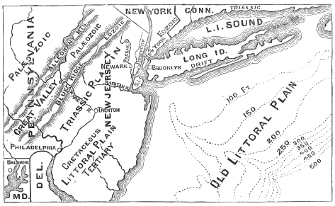
Fig. 50.—Map showing old channel and mouth of the Hudson (dewberry).
The more accurate surveys conducted from 1880 to 1884 have brought to our knowledge the facts about this submarine valley almost as clearly as those relating to the inland portion of it above New York city. According to Mr. A. Lindenkohl,[CA] this submarine valley began to be noticeable in the soundings ten miles southeast of Sandy Hook. The depth of the water where the channel begins is nineteen fathoms (114 feet). Ten miles out the channel has sunk ninety feet below the general depth of the water on the bank, and continues at this depth for twenty miles farther. This narrow channel continues with more or less variation for a distance of seventy-five miles, where it suddenly enlarges to a width of three miles and to a depth of 200 fathoms, or 1,200 feet, and extends for a distance of twenty-five miles, reaching near that point a depth of 474 fathoms, or 2,844 feet. According to Mr. Lindenkohl, this ravine maintains for half its length "a vertical depth of more than 2,000 feet, measuring from the top of its banks, and the banks have a nearly uniform slope of about 14°.” The mouth of the ravine opens out into the deep basin of the central Atlantic.
With little question there is brought to light in these remarkable investigations a channel eroded by the extension of the Hudson River, into the bordering shelf of the Atlantic basin at a time when the elevation of the continent was much greater than now. This is shown to have occurred in late Tertiary or post-Tertiary times by the fact that the strata through which it is worn are the continuation of the Tertiary deposits of New Jersey. The subsidence to its present level has probably been gradual, and, according to Professor Cook, is still continuing at the rate of two feet a century.
Similar submarine channels are found extending out from the present shore-line to the margin of the narrow shelf bordering the deep water of the central Atlantic running from the mouth of the St. Lawrence River, through St. Lawrence Bay, and through Delaware and Chesapeake Bays.[CB] All these submerged fiords on the Atlantic coast were probably formed during a continental elevation which commenced late in the Tertiary period, and reached the amount of from 2,000 to 3,000 feet in the northern part of the continent.
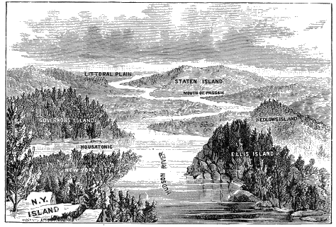
Fig. 51.—New York harbor in preglacial times looking south, from south end of New York Island (Newberry).
To this period must probably be referred also the formation of the gorge, or more properly fiord, of the Saguenay, which joins the St. Lawrence below Quebec. The great depth of this fiord is certainly surprising, since, according to Sir William Dawson, its bottom, for fifty miles above the St. Lawrence, is 840 feet below the sea-level, while the bordering cliffs are in some places 1,500 feet above the water. The average width is something over a mile.
It seems impossible to account for such a deep gorge extending so far below the sea-level, except upon the supposition of a long-continued continental elevation, which should allow the stream to form a cañon to an extent somewhat comparable with that of the cañons of the Colorado and other rivers in the far West. Then, upon the subsidence of the continent to the present level, it would remain partially or wholly submerged, as we find it at the present time. During the Glacial period it was so filled with ice as to prevent silting up. The rivers entering the Pacific Ocean, both in the United States and in British Columbia, are also lost in submerged channels extending out to the deeper waters of the Pacific basin in a manner closely similar to the Atlantic streams which have been mentioned.
During this continental elevation which preceded, accompanied, and perhaps brought on the Glacial period, erosion must have proceeded with great intensity along all the lines of drainage, and throughout the whole region which is now covered, and to a considerable extent smoothed over, by glacial deposits, and the whole country must have presented a very different appearance from what it does now.
A pretty definite idea of its preglacial condition can probably be formed by studying the appearance of the regions outside of and adjoining that which was covered by the continental glacier. The contrast between the glaciated and the unglaciated region is striking in several respects aside from the presence and absence of transported rocks and other débris, but in nothing is it greater than in the extent of river erosion which is apparent upon the surface. For example, upon the western flanks of the Alleghanies the regions south of the glacial limit is everywhere deeply channeled by streams. Indeed, so long have they evidently been permitted to work in their present channels that, wherever there have been waterfalls, they have receded to the very head-waters, and no cataracts exist in them at the present time. Nor are there in the unglaciated region any lakes of importance, such as characterize the glaciated region. If there have been lakes, the lapse of time has been sufficient for their outlets to lower their beds sufficiently to drain the basins dry.
On entering the glaciated area all this is changed. The ice-movement has everywhere done much to wear down the hills and fill the valleys, and, where there was débris enough at command, it has obliterated the narrow gorges originally occupied by the preglacial streams. Thus it has completely changed the minor lines of superficial drainage, and in many instances has produced most extensive and radical changes in the whole drainage system of the region. In the glaciated area, channels buried beneath glaciated débris are of frequent occurrence, while many of the streams which occupy their preglacial channels are flowing at a very much higher level than formerly, the lower part of the channel having been silted up by the superabundant débris accessible since the glacial movement began.
Buried Outlets and Channels.
It is easy to see how the great number of shallow lakes which frequent the glaciated region were formed by the irregular deposition of glacial débris, but it is somewhat more difficult to trace out the connection between the Glacial period and the Great Lakes of North America, several of which are of such depth that their bottoms are some hundreds of feet below the sea-level, Lake Erie furnishing the only exception. This lake is so shallow that it is easy to see how its basin may have been principally formed by river erosion, while it is evident that such must have been the mode of its formation, since it is surrounded by sedimentary strata lying nearly in a horizontal position.
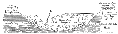
Fig. 52.—Section across the valley of the Cuyahoga River, twenty miles above its mouth (Claypole).
That Lake Erie is really nothing but a “glacial mill-pond” is proved also by much direct evidence, especially that derived from the depth of the buried channels of the streams flowing into it from the south. Of these, the Cuyahoga River, which enters the lake at Cleveland, has been most fully investigated. In searching for oil, some years ago, borings were made at many places for twenty-five miles above the mouth of the river. As a result, it appeared that for the whole distance the rocky bottom of the gorge was about two hundred feet below the present bottom of the river, while the river itself is two or three hundred feet below the general level of the country, occupying a trough about half a mile in width, with steep, rocky sides. These facts indicate that at one time the river must have found opportunity to discharge its contents at a level two hundred feet below that of the present lake, while an examination of the material filling up the bottom of the gorge to its present level shows it to be glacial débris, thus proving that the silting up was accomplished during the Glacial period.
As the water of Lake Erie is for the most part less than one hundred feet in depth, and is nowhere much more than two hundred feet deep, it is clear that the preglacial outlet which drained it down to the level of the rocky bottom of the Cuyahoga River must have destroyed the lake altogether. Hence Ave may be certain that, before the Glacial period, the area now covered by the lake was simply a broad, shallow valley through which there coursed a single river of great magnitude, with tributary branches occupying deep gorges. Professor J. W. Spencer has shown with great probability that the old line of drainage from Lake Erie passed through the lower part of the valley of Grand River, in Canada, and entered Lake Ontario at its western extremity, and that during the great Ice age this became so completely obstructed with glacial débris as to form an impenetrable dam, and to cause the pent-up water to flow through the Niagara Valley, which chanced to furnish the lowest opening.
In speaking of the present area of Lake Erie, however, as being then occupied by a river valley, we do not mean to imply that it was not afterwards greatly modified by glacial erosion; for undoubtedly this was the case, whatever views we may have as to the relative efficiency of ice and water in scooping out lake basins.
In the case of Lake Erie, we need suppose no change of level to account for the erosion of its basin, but only that, since the strata in which it is situated were deposited, time enough had elapsed for a great river to cut a gorge extending from the western end of Lake Ontario through to the present bed of Lake Erie, and that here a great enlargement of the valley was occasioned by the existence of deep beds of soft shale which could easily be worn away by a ramifying system of tributary streams. Rivers acting at present relative levels would be amply sufficient to produce the results which are here manifest.
But in the case of Lakes Ontario, Huron, Michigan, and Superior, whose depths descend considerably below the sea-level, we must suppose that they were, in the main, eroded when the continent was so much elevated that their bottoms were brought above tide-level. The depth of Lake Ontario implies the existence of an outlet more than four hundred feet lower than at present, which, of course, could exist only when the general elevation was more than four hundred feet greater than now.
The existence of an outlet at that depth seems to be proved also by the fact that at Syracuse, where numerous wells have been sunk to obtain brine for the manufacture of salt, deposits of sand, gravel, and rolled stones, four hundred and fifty feet thick, are penetrated without reaching rock. Since this lies in the basin of Lake Ontario, it follows that if the basin itself has been produced by river erosion, the land must have been of sufficient height to permit an outlet through a valley, or cañon, of the required depth, and this outlet must now be buried beneath the abundant glacial débris that covers the region.
Professor Newberry, who has studied the vicinity carefully, is of the opinion that there is ample opportunity for such a line of drainage to have extended through the Mohawk Valley to the Hudson River. But, at Little Falls, a spur of the Adirondack Mountains projects into the valley, and the Archæan rocks over which the river runs are so prominent and continuous that some have thought it impossible for the requisite channel to have ever existed there. Extensive deposits of glacial débris, however, are found in the vicinity, especially in places some distance to the north, and in Professor Newberry’s opinion the existence of a buried channel around the obstruction upon the north side is by no means improbable.
The preglacial drainage of Lake Huron has not been determined with any great degree of probability. Professor Spencer formerly supposed that it passed from the southern end of the lake through London, in the western part of Ontario, and reached the Erie basin near Port Stanley, and so augmented the volume of the ancient river which eroded the buried cañon from Lake Erie to Lake Ontario. But he now supposes, though the evidence is by no means demonstrative, that the waters of Lake Huron passed into Lake Ontario by means of a channel extending from Georgian Bay to the vicinity of Toronto.
With a fair degree of probability, the basin of Lake Superior is supposed by Professor Newberry to have been joined to that of Lake Michigan by some passage, now buried, considerably to the west of the Strait of Mackinac, and thence to have had an outlet southward from the vicinity of Chicago directly into the Mississippi River. Of this there is considerable evidence furnished by deeply buried channels which have been penetrated by borings in various places in Kankakee, Livingston, and McLean Counties, Illinois; but the whole area extending from Lake Michigan to the Mississippi is so deeply covered with glacial débris that the surface of the country gives no satisfactory indication of the exact lines of preglacial drainage.
Some of the most remarkable instances of ancient river channels buried by the glacial deposits have been brought to light in southwestern Ohio, where there has been great activity in boring for gas and oil. At St. Paris, Champaign County, for example, in a locality where the surface of the rock near by was known to be not far below the general level, a boring was begun and continued to a depth of more than five hundred feet without reaching rock, or passing out of glacial débris.
Many years ago Professor Newberry collected sufficient facts to show that pretty generally the ancient bed of the Ohio River was as much as 150 feet below that over which it now flows. During a continental elevation the erosion had proceeded to that extent, and then the channel had been silted up during the Glacial period with the abundant material carried down by the streams from the glaciated area. One of the evidences of the preglacial depth of the channel of the Ohio was brought to light at Cincinnati, where “gravel and sand have been found to extend to a depth of over one hundred feet below low-water mark, and the bottom of the trough has not been reached.” In the valley of Mill Creek, also, “in the suburbs of Cincinnati, gravel and sand were penetrated to the depth of 120 feet below the stream before reaching rock.” But from the general appearance of the channel, Professor J. F. James was led to surmise that a rock bottom extended all the way across the present channel of the Ohio, between Price Hill and Ludlow, Ky., a short distance below Cincinnati, which would preclude the possibility of a preglacial outlet at the depth disclosed in that direction. Mr. Charles J. Bates (who was inspector of the masonry for the Cincinnati Southern Railroad while building the bridge across the Ohio at this point) informs me that Mr. James’s surmise is certainly correct, and that his “in all probability” may be displaced by “certainly,” since the bedded rocks supposed by Professor James to extend across the river a few feet below its present bottom were found by the engineers to be in actual existence.
In looking for an outlet for the waters of the upper Ohio which should permit them to flow off at the low level reached in the channel at Cincinnati, Professor James was led to inspect the valley extending up Mill Creek to the north towards Hamilton, where it joins the Great Miami. The importance of Mill Creek Valley is readily seen in the fact that the canal and the railroads have been able to avoid heavy grades by following it from Cincinnati to Hamilton. As a glance at a map will show, it is also practically but a continuation of the northerly course pursued by the Ohio for twenty miles before reaching Cincinnati. This, therefore, was a natural place in which to look beneath the extensive glacial débris for the buried channel of the ancient Ohio, and here in all probability it has been found. The borings which have been made in Milk Creek Valley north of Cincinnati, show that the bedded rock lies certainly thirty-four feet below the low-water mark of the Ohio just below Cincinnati, while at Hamilton, twenty-five miles north of Cincinnati, where the valley of the Great Miami is reached, the bedded rock of the valley lies as much as ninety feet below present low-water mark in the Ohio.
Other indications of the greater depth of the preglacial gorge of the Ohio are abundant. “At the junction of the Anderson with the Ohio, in Indiana, a well was sunk ninety-four feet below the level of the Ohio before rock was found.” At Louisville, Ky., the occurrence of falls in the Ohio seemed at first to discredit the theory in question, but Professor Newberry was able to show that the falls at Louisville are produced by the water’s being now compelled to flow over a rocky point projecting from the north side into the old valley, while to the south there is ample opportunity for an old channel to have passed around this point underneath the city on the south side. The lowlands upon which the city stands are made lands, where glacial débris has filled up the old channel of the Ohio.
Above Cincinnati the tributaries of the Ohio exhibit the same phenomena. At New Philadelphia, Tuscarawas County, the borings for salt-wells show that the Tuscarawas is running 175 feet above its ancient bed. The Beaver, at the junction of the Mahoning and Shenango, is flowing 150 feet above the bottom of its old trough, as is demonstrated by a large number of oil-wells bored in the vicinity. Oil Creek is shown by the same proofs to run from 75 to 100 feet above its old channel, and that channel had sometimes vertical and even overhanging walls.[CC]
The course of preglacial drainage in the upper basin of the Alleghany River is worthy of more particular mention. Mr. Carll, of the Pennsylvania Geological Survey, has adduced plausible reasons for believing that previous to the Glacial period the drainage of the valley of the upper Alleghany north of the neighbourhood of Tidioute, in Warren County, instead of passing southward as now, was collected into one great stream flowing northward through the region of Cassadaga Lake to enter the Lake Erie basin at Dunkirk, N. Y. The evidence is that between Tidioute and Warren the present Alleghany is shallow, and flows over a rocky basin; but from Warren northward along the valley of the Conewango, the bottom of the old trough lies at a considerably lower level, and slopes to the north. Borings show that in thirteen miles the slope of the preglacial floor of Conewango Creek to the north is 136 feet. The actual height above tide of the old valley floor at Fentonville, where the Conewango crosses the New York line, is only 964 feet; while that of the ancient rocky floor of the Alleghany at Great Bend, a few miles south of Warren, was 1,170 feet. Again, going nearer the head-waters of the Alleghany, in the neighbourhood of Salamanca, it is found that the ancient floor of the Alleghany is, at Carrollton, 70 feet lower than the ancient bed of the present stream at Great Bend, about sixty miles to the south; while at Cole’s Spring, in the neighbourhood of Steamburg, Cattaraugus County, N. Y., there has been an accumulation of 315 feet of drift in a preglacial valley whose rocky floor is 155 feet below the ancient rocky floor at Great Bend. Unless there has been a great change in levels, there must, therefore, have been some other outlet than the present for the waters collecting in the drainage basin to the north of Great Bend.[CD]
While there are numerous superficial indications of buried channels running towards Lake Erie in this region, direct exploration has not been made to confirm these theoretical conclusions. In the opinion of Mr. Carll, Chautauqua Lake did not flow directly to the north, but, passing through a channel nearly coincident with that now occupied by it, joined the northerly flowing stream a few miles northeast from Jamestown.[CE] It is probable, however, that Chautauqua did not then exist as a lake, since the length of preglacial time would have permitted its outlet to wear a continuous channel of great depth corresponding to that known to have existed in the Conewango and upper Alleghany.
The foregoing are but a few of the innumerable instances where the local lines of drainage have been disturbed, and even permanently changed, by the glacial deposits. Almost every lake in the glaciated region is a witness to this disturbance of the established lines of drainage by glacial action, while in numerous places where lakes do not now exist they have been so recently drained that their shore-lines are readily discernible.
An interesting instance of the recent disappearance of one of these glacial lakes is that of Runaway Pond, in northern Vermont. In the early part of the century the Lamoille River had its source in a small lake in Craftsbury, Orleans County. The sources of the Missisquoi River were upon the same level just to the north, and the owner of a mill privilege upon this latter stream, desiring to increase his power by obtaining access to the water of the lake, began digging a ditch to turn it into the Missisquoi, but no sooner had he loosened the thin rim of compact material which formed the bottom and the sides of the inclosure, than the water began to rush out through the underlying and adjacent quicksands. This almost instantly enlarged the channel, and drained the whole body of water oft 3 in an incredibly short time. As a consequence, the torrent went rushing down through the narrow valley, sweeping everything before it; and nothing but the unsettled condition of the country prevented a disaster like that which occurred in 1889 at Johnstown, Pa. Doubtless there are many other lakes held in position by equally slender natural embankments. Artificial reservoirs are by no means the only sources of such danger.
The buried channel of the old Mississippi River in the vicinity of Minneapolis is another instructive example of the instability of many of the present lines of drainage. The gorge of the Mississippi River extending from Fort Snelling to the Falls of St. Anthony at Minneapolis is of post-glacial origin. One evidence of this is its narrowness when contrasted with the breadth of the valley below Fort Snelling. Below this point the main trough of the Mississippi has a width of from two to eight miles, and the faces of the bluffs on either side show the marks of extreme age. The tributary streams also have had time to wear gorges proportionate to that of the main stream, and the agencies which oxidise and discolor the rocks have had time to produce their full effects. But from Fort Snelling up to Minneapolis, a distance of about seven miles, the gorge is scarcely a quarter of a mile in width, and the faces of the high, steep bluffs on either side are remarkably fresh looking by comparison with those below; while the tributary gorges, of which that of the Minnehaha River is a fair specimen, are very limited in their extent.
Upon looking for the cause of this condition of things we observe that the broad trough of the Mississippi River, which had characterised it all the way below Fort Snelling, continues westward, without interruption, up the valley of the present Minnesota River, and, what seems at first most singular, it does not cease at the sources of the Minnesota, but, through Lake Traverse and Big Stone Lake, is continuous with the trough of the Red River of the North.
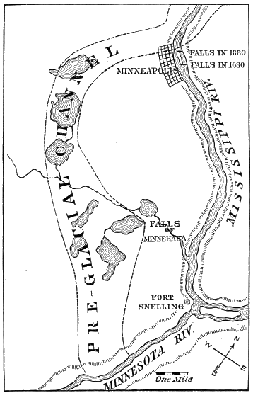
Fig. 53.—Map of Mississippi River from Fort Snelling to Minneapolis and the vicinity, showing the extent of the recession of the Falls of St. Anthony since the great Ice age. Notice the greater breadth of the valley of the Minnesota River as described in the text (Winchell).
Deferring, however, for a little the explanation of this, we will go back to finish the history of the preglacial channel around the Falls of St. Anthony. As early as the year 1876 Professor N. H. Winchell had collected sufficient evidence from wells, one of which had been sunk to a depth of one hundred and seventy-five feet, to show that the preglacial course of the stream corresponding to the present Mississippi River ran to the west of Minneapolis and of the Falls of Minnehaha, and joined the main valley some distance above Fort Snelling, as shown in the accompanying map.
This condition of things was at one time very painfully brought to the notice of the citizens of Minneapolis. A large part of the wealth of the city at that time consisted of the commercial value of the water-power furnished by the Falls of St. Anthony. To facilitate the discharge of the waste water from their wheels, some mill-owners dug a tunnel through the soft sandstone underlying the limestone strata over which the river falls; but it very soon became apparent that the erosion was proceeding with such rapidity that in a few years the recession of the falls would be carried back to the preglacial channel, when the river would soon scour out the channel and destroy their present source of wealth. The citizens rallied to protect their property, and spent altogether as much as half a million dollars in filling up the holes that had been thoughtlessly made; but so serious was the task that they were finally compelled to appeal for aid to the United States Government. Permanent protection was provided by running a tunnel, some ways back from the falls, completely across the channel, through the soft sandstone underlying the limestone, and filling this up with cement hard enough and compact enough to prevent the further percolation of the water from above.
Ice-Dams.
The foregoing changes in lines of drainage due to the Glacial period were produced by deposits of earthy material in preglacial channels. Another class of temporary but equally interesting changes were produced by the ice itself acting directly as a barrier.
Many such lakes on a small scale are still in existence in various parts of the world. The Merjelen See in Switzerland is a well-known instance. This is a small body of water held back by the great Aletsch Glacier, in a little valley leading to that of the Fiesch Glacier, behind the Eggischorn. At irregular intervals the ice-barrier gives way, and allows the water to rush out in a torrent and flood the valley below. Afterwards the ice closes up again, and the water reaccumulates in preparation for another flood.
Other instances in the Alps are found in the Mattmark See, which fills the portion of the Saas Valley between Monte Rosa and the Rhône. This body of water is held in place by the Allalin Glacier, which here crosses the main valley. The Lac du Combal is held back by the Glacier de Miage at the southern base of Mont Blanc. “A more famous case is that of the Gietroz Glacier in the valley of Bagnes, south of Martigny. In 1818 this lake had grown to be a mile long, and was 700 feet wide and 200 feet deep. An attempt was made to drain it by cutting through the ice, and about half the water was slowly drawn off in this way; but then the barrier broke, and the rest of the lake was emptied in half an hour, causing a dreadful flood in the valley below. In the Tyrol, the Vernagt Glacier has many times caused disastrous floods by its inability to hold up the lake formed behind it. In the northwestern Himalaya, the upper branches of the Indus are sometimes held back in this way. A noted flood occurred in 1835; it advanced twenty-five miles in an hour, and was felt three hundred miles down-stream, destroying all the villages on the lower plain, and strewing the fields with stones, sand, and mud.”[CF]