Front matter
Reading edition
Photo, Ridge Studio; Courtesy Ogden Chamber of Commerce
A great ledge in Ogden Canyon near Ogden, Utah. The rock, still retaining its stratification, was deposited layer upon layer horizontally mostly as sand upon the floor of a sea which covered the region fully 25,000,000 years ago. That the sea was of very early Paleozoic (i.e., Cambrian) age has been proved by fossils in associated strata. Long after their deep burial and consolidation within the earth, the strata were subjected to tremendous mountain-making pressure, notably altered to a rock called “Quartzite,” raised high above sea level, and tilted almost vertically. Then through long ages (millions of years) overlying rocks of great thickness have been cut away (eroded) by weathering and stream action, laying bare the ledge as we see it to-day.
Popular Science Library
EDITOR-IN-CHIEF GARRETT P. SERVISS
AUTHORS WILLIAM J. MILLER HIPPOLYTE GRUENER A. RUSSELL BOND D. W. HERING LOOMIS HAVEMEYER ERNEST G. MARTIN ARTHUR SELWYN-BROWN ROBERT CHENAULT GIVLER ERNEST INGERSOLL WILFRED MASON BARTON WILLIAM B. SCOTT ERNEST J. STREUBEL NORMAN TAYLOR DAVID TODD CHARLES FITZHUGH TALMAN ROBIN BEACH
ARRANGED IN SIXTEEN VOLUMES WITH A HISTORY OF SCIENCE, GLOSSARIES AND A GENERAL INDEX ILLUSTRATED

VOLUME THREE
P. F. COLLIER & SON COMPANY NEW YORK
Copyright 1922 By P. F. Collier & Son Company MANUFACTURED IN U. S. A.
GEOLOGY
The Science of the Earth’s Crust
BY
WILLIAM J. MILLER Professor of Geology, Smith College

P. F. COLLIER & SON COMPANY NEW YORK
PREFACE
I
In the preparation of this book the author has attempted to present, in popular form, the salient points of a general survey of the whole great science of geology, the science which deals with the history of the earth and its inhabitants as revealed in the rocks.
The use of technical and unusual terms has been reduced to a minimum compatible with a reasonable understanding of the subject by the layman. Each of the relatively few scientific terms is explained where first used in the text, and a glossary of common geological terms has been appended.
The matter of illustrations has received very careful attention, and only pictures, maps, and diagrams are used which actually illustrate important features of the text. A special point has been made to introduce only cuts of simple construction comparatively free from technicalities. Nearly every illustration is accompanied by a really explanatory title.
A number of the pictures are from the author’s collection of photographs, and many of the line-cuts have either been made or considerably modified by the author. Among the numerous sources of illustrations, special mention should be made of the United States Geological Survey, the New York State Museum, the American Museum of Natural History, the University of Chicago Press, and various individuals, full credit being given wherever due.
William J. Miller.
Northampton, Mass.
CONTENTS
CHAPTER PAGE
I. Introduction 9
II. Weathering and Erosion 22
III. Stream Work 30
IV. The Sea and Its Work 51
V. Glaciers and Their Work 59
VI. The Action of Wind 71
VII. Instability of the Earth’s Crust 76
VIII. Volcanoes and Igneous Rocks 99
IX. Waters Within the Earth 113
X. How Mountains Come and Go 130
XI. A Study of Lakes 142
XII. How the Earth May Have Originated 158
XIII. Very Ancient Earth History 164
XIV. Ancient Earth History 179
XV. Medieval Earth History 208
XVI. Modern Earth History 221
XVII. Evolution of Plants 249
XVIII. Geological History of Animals (Excluding Vertebrates) 259
XIX. Geological History of Vertebrate Animals (Including Man) 281
XX. Mineralogy 307
XXI. Economic Geology 342
Glossary of Common Geological Terms 377
LIST OF ILLUSTRATIONS
Ledge of Rock with Nearly Vertical Strata Frontispiece
PLATE FACING PAGE
1. Granite Weathering to Soil Leaving Residual Cores of Joint Blocks (Upper picture) 32
Looking-Glass Rock, Utah. Stratified Sandstone Sculptured by Wind Erosion (Lower picture) 32
2. Grand Canyon of the Yellowstone River. A Channel Worn by Erosion 33
3. Gorge of the Niagara River Below the Falls. A Sample of Recent Erosion 64
4. Winding Stream in the St. Lawrence Valley with Flood Plain (Upper picture) 65
Davidson Glacier, Alaska, Showing Action on the Valley’s Walls and Floor (Lower picture) 65
5. Swift Current Valley in Glacier National Park, Formed by Stream and Glacier Action 96
6. Yosemite Valley from Western Entrance. The Result of Glacial Action 97
7. An Upbend Fold or Anticline in Maryland 128
8. Ledge of Igneous Rock Showing Joints (Upper picture) 129
Fault Fracture in Limestone Formations (Lower pictures) 129
9. Molten Lava Flowing Over a Cliff in Hawaii (Upper picture) 160
Dikes of Granite Cutting Old Rock (Lower picture) 160
10. Lassen Peak, California, in Eruption (Left picture) 161
Devil’s Tower, Wyoming, Once a Mass of Molten Rock Forced Through Strata (Right picture) 161
11. Mammoth Hot Springs Terrace in Yellowstone National Park (Upper picture) 224
Crater Lake, Oregon, Formed by the Subsidence of a Volcano (Lower picture) 224
12. Archeozoic Rock, Oldest Known Rock Formation on Earth (Upper picture) 225
Twisted Mass of Stratified Limestone, Surrounded by Granite (Lower picture) 225
13. Paleozoic Rock, Covered with Oldest Known Animal Remains 256
14. “Stone-Lily” Stems in Ordovician Strata (Upper left picture) 257
Various Brachiopods in Ordovician Strata (Upper right picture) 257
Stratified Limestone of Middle Ordovician Era Containing Fossils (Lower picture) 257
15. A Landscape of the Coal Age (Upper picture) 288
Fossil Fern on a Piece of Shale (Lower picture) 288
16. Restoration of Huge Animals of the Mesozoic Era 289
17. Skeleton of Two-Legged Carnivorous Dinosaur (Large picture) 320
Earliest Known Bird Form (Insert) 320
18. Skeleton of Large Flying Reptile (Upper picture) 321
Skeleton of a Swimming Reptile of the Mesozoic Era (Lower picture) 321
19. Appalachians Along New River, Peneplain Upraised Again 352
20. Glacial Bowlder Left by Ice Sheet (Upper picture) 353
Esker, Deposited by a Stream in the Great Glacier (Lower picture) 353
CHAPTER I
INTRODUCTION
E
EARTH features are not fixed. The person of ordinary intelligence, surrounded as he is by a great variety of physical features, is, unless he has devoted some study to the subject, very likely to regard those features as practically unchangeable, and to think that they are now essentially as they were in the beginning of the earth’s history. Some of the most fundamental ideas taught in this book are that the physical features of the earth, as we behold them to-day, represent but a single phase of a very long-continued history; that significant changes are now going on all around us; and that we are able to interpret present-day earth features only by an understanding of earth changes in the past.
Geology, meaning literally “earth science,” deals with the history of the earth and its inhabitants as revealed in the rocks. The science is very broad in its scope. It treats of the processes by which the earth has been, and is now being, changed; the structure of the earth; the stages through which it has passed; and the evolution of the organisms which have lived upon it.
Geography deals with the distribution of the earth’s physical features, in their relation to one another, to the life of sea and land, and human life and culture. It is the present and outward expression of geological effects.
As a result of the work of many able students of geology during the past century and a quarter, it is now well established that our planet has a definitely recorded history of many millions of years, and that during the lapse of those eons, revolutionary changes in earth features have occurred, and also that there has been a vast succession of living things which, from very early times, have gradually passed from simple into more and more complex forms. The physical changes and the organisms of past ages have left abundant evidence of their character, and the study of the rock formations has shown that within them we have a fairly complete record of the earth’s history. Although very much yet remains to be learned about this old earth, it is a remarkable fact that man, through the exercise of his highest faculty, has come to know so much concerning it.
The following words, by the late Professor Barrell, admirably summarize the significance of geological history. "The great lesson taught by the study of the outer crust is that the earth mother, like her children, has attained her present form through ceaseless change, which marks the pulse of life and which shall cease only when her internal forces slumber and the cloudy air and surf-bound ocean no more are moving garments. The flowing landscapes of geologic time may be likened to a kinetoscopic panorama. The scenes transform from age to age, as from act to act; seas and plains and mountains of different types follow and replace each other through time, as the traveler sees them succeed each other in space. At times the drama hastens, and unusual rapidity of geologic action has, in fact, marked those epochs since man has been a spectator upon the earth. Science demonstrates that mountains are transitory forms, but the eye of man through all his lifetime sees no change, and his reason is appalled at the conception of a duration so vast that the milleniums of written history have not accomplished the shifting of even one of the fleeting views which blend into the moving picture."[A]
Or in the words of Tennyson:
There rolls the deep where grew the tree. O, earth, what changes hast thou seen! There where the long street roars, hath been The stillness of the central sea. The hills are shadows, and they flow From form to form, and nothing stands; They melt like mist, the solid lands, Like clouds they shape themselves and go.
The following statement of some of the more definite important conclusions regarding earth changes may serve to make still clearer the general scope of the science of geology. The evidences upon which these conclusions are based are discussed in various parts of this book. For untold millions of years the rocks at and near the earth’s surface have been crumbling; streams have been incessantly sawing into the lands; the sea has been eating into continental masses; the winds have been sculpturing desert lands; and, more intermittently and locally, glaciers have plowed through mountain valleys, and even great sheets of ice have spread over considerable portions of continents. Throughout geologic time, the crust of the earth has shown marked instability. Slow upward and downward movements of the lands relative to sea level have been very common, in many cases amounting to even thousands of feet. Various parts of the earth have been notably affected by sudden movements (resulting in earthquakes) along fractures in the outer crust. During millions of years molten materials have, at various times, been forced into the earth’s crust, and in many cases to its surface. Mountain ranges have been brought forth and cut down. The site of the Appalachian Mountains was, millions of years ago, the bottom of a shallow sea. Lakes have come and gone. The Great Lakes have come into existence very recently (geologically), that is to say, since the great Ice Age. A study of stratified rocks of marine origin shows that all, or nearly all, of the earth’s surface has at some time, or times, been covered by sea water. Over certain districts the sea has transgressed and retrogressed repeatedly. Organisms have inhabited the earth for many millions of years. In earlier known geologic time, the plants and animals were comparatively simple and low in the scale of organization, and through the succeeding ages higher and more complex types were gradually evolved until the highly organized forms of the present time, including the human race, were produced.
The rocks of the earth constitute the special field of study for the geologist because they contain the records of events through which the earth and its inhabitants have passed during the millions of years of time until their present conditions have been reached. All the rocks of the earth’s crust may be divided into three great classes: igneous, sedimentary, and metamorphic.
Igneous rocks comprise all those which have ever been in a molten condition, and of these we have the volcanic rocks (for example, lavas), which have cooled at or near the surface; plutonic rocks (for example, granites), which have cooled in great masses at considerable depths below the surface; and the dike rocks which, when molten, have been forced into fissures in the earth’s crust and there cooled.
Sedimentary rocks comprise all those which have been deposited under water, except some wind-blown deposits, and they are nearly always arranged in layers (stratified). Such rocks are called strata. They may be of mechanical origin such as clay or mud which hardens to shale; sand, which consolidates into sandstone; and gravel, which when cemented becomes conglomerate. They may be of organic origin such as limestone, most of which is formed by the accumulation of calcareous shells; flint and chert, which are accumulations of siliceous shells; or coal, which is formed by the accumulation of partly decayed organic matter. Or, finally, they may be formed by chemical precipitation, as beds of salt, gypsum, bog iron ore, etc.
Metamorphic rocks include both sedimentary and igneous rocks which have been notably changed from their original condition. Traces or remains of plants and animals preserved in the rocks are known as fossils. The term originally meant anything dug out of the earth, whether organic or inorganic, but for many years it has been strictly applied to organic remains. Many thousands of species of fossils are known from rocks of all ages except the oldest, and more are constantly being brought to light, but these represent only a small part of the life of past ages because relatively few organic remains were deposited under conditions favorable for preservation in fossil form. The fossils in the rocks are, however, a fair average of the groups of organisms to which they belong. It is really remarkable that such a vast number of fossils are imbedded in the rocks, and from a study of these many fundamental conclusions regarding the history of life on our planet may be drawn.
As early as the fifth century B. C., Xenophanes is said to have observed fossil shells and plants in the rocks of Paros, and to have attributed their presence to incursions of the sea over the land. Herodotus, about a century later, came to a similar conclusion regarding fossil shells in the mountains of Egypt. None of the ancients, however, seemed to have the slightest conception of the significance of fossils as time markers in the history of the earth. (See discussion below.)
In the Middle Ages, distinguished writers held curious views regarding fossils. Thus Avicenna (980-1037) believed that fossils represented unsuccessful attempts on the part of nature to change inorganic materials into organisms within the earth by a peculiar creative force (vis plastica). About two centuries later, Albertus Magnus held a somewhat similar view. Leonardo da Vinci (1452-1519), the famous artist, architect, and engineer, while engaged in canal building in northern Italy, saw fossils imbedded in the rocks, and concluded that these were the remains of organisms which actually lived in sea water which spread over the region. During the seventeenth and eighteenth centuries, many correctly held that fossils were really of organic origin, but it was commonly taught that all fossils represented remains of organisms of an earlier creation which were buried in the rocks during the great Deluge (Noah’s Flood). William Smith (1769-1839), of England, was, however, the first to recognize the fundamental significance of fossils for determining the relative ages of sedimentary rocks. This discovery laid the foundation for the determination of earth chronology which is of great importance in the study of the history of the earth. (See discussions below.)
Organic remains, dating as far back as tens of millions of years, have been preserved in the rocks of the earth in various ways. A very common kind of fossilization is the preservation of only the hard parts of organisms. Thus the soft parts have disappeared by decomposition, while the hard parts, such as bones, shells, etc., remain. In many cases practically complete skeletons of large and small animals which lived millions of years ago have been found intact in the rocks. Fossils which show none of the original material, but only the shape or form, are also very abundant. When sediment hardens around an imbedded organism, and the organism then decomposes or dissolves away, a cavity or fossil mold only is left. Casts of organisms or parts of them are formed by filling shells or molds with sediment or with mineral matter carried in solution by underground water. Only rarely have casts of wholly soft animals been found in ancient rocks. In other cases both original form and structure are preserved, but none of the original material. This is known as petrifaction which takes place when a plant or hard part of an animal has been replaced, particle by particle, by mineral matter from solution in underground water. Not uncommonly organic matter, such as wood, or inorganic matter, such as carbonate of lime shells, has been so perfectly replaced that the original structures are preserved almost as in life. The popular idea that petrified wood is wood which has been changed into stone is, of course, incorrect. It is doubtful if flesh has ever been truly petrified. In many cases mainly the carbon only of organisms has been preserved. This is also true of plants where, under conditions of slow chemical change or decomposition, the hydrogen and oxygen mostly disappear, leaving much of the carbon with original structures often remarkably preserved. Fine examples are fossil plants in the great coal-bearing strata. Much more rarely entire organisms have been preserved either by freezing or by natural embalmment. Most remarkable are the species of mammoths and rhinoceroses, extinct for thousands of years, bodies of which, with flesh, hide, and hair still intact, have been held in cold storage in the frozen soils of Siberia, or other cases. Insects have been perfectly preserved in amber, as, for example, in the Baltic region. This amber is a hardened resin in which the insects were caught while it was still soft and exuding from the trees. Finally, we should mention the preservation of tracks and trails of land and water animals. Thousands of tracks of long-extinct great reptiles occur in the sandstones and shales of the Connecticut Valley of Massachusetts. The footprints were made in soft sandy mud which hardened and then became covered with more sediment.
Few fossils occur in other than the sedimentary rocks. Most numerous, by far, are fossils in rocks of marine origin, because on relatively shallow sea bottoms, where sediments of the geologic ages have largely accumulated, the conditions for fossilization have been most favorable. Among the many conditions which have produced great diversity in numbers and distribution of marine organisms during geologic time are temperature, depth of water, clearness of water, nature of sea bottom, degree of salinity, and food supply. River and lake deposits also not uncommonly contain remains of organisms which inhabited the waters, but also others which were carried in. “Surrounding trees drop their leaves, flowers, and fruit upon the mud flats, insects fall into the quiet waters, while quadrupeds are mired in mud or quicksand and soon buried out of sight. Flooded streams bring in quantities of vegetable debris, together with carcasses of land animals drowned by the sudden rise of the flood” (W. B. Scott).
In the study of the many changes which have taken place in the history of the earth, a fundamental consideration is the determination of the relative ages of the rocks, especially the strata. How can the geologist assign a rock formation of any part of the earth to a particular age in the history of the earth? How can it be proved that certain rock formations in various parts of the earth originated practically at the same time? There are two important criteria. First, in any region where the strata have not been disturbed from their normal order, the older strata underlie the younger because the underlying sediments must have been deposited first. Now, the total thickness of the stratified series of the earth has been estimated to be no less than 200,000 feet and only a small part of this is actually present in any given locality or region. It is, therefore, evident that the order of superposition of strata is in itself not sufficient for the determination of the relative ages of all the strata in even a considerable portion of a single continent, not to mention its utter inadequacy in building up the geological column of the whole earth. When, however, the second criterion, namely, the fossil content of the strata, is used in direct connection with the order of superposition, we have the real basis for determining the relative ages of strata for all parts of the earth. The discovery of this method was very largely due to the painstaking field work in England by William Smith about the beginning of the nineteenth century.
It is a well-established fact that organisms have inhabited the earth for many millions of years and that, through the geologic ages, they have continuously changed, with gradual development of higher and higher types. Tens of thousands of species have come and gone. Accepting this fact, it is then clear that strata which were formed at notably different times must contain notably different fossils, while strata which accumulated at practically the same time contain similar fossils, allowing, of course, for reasonable differences in geographical distribution of organisms as at the present time. Each epoch of earth history or series of strata has its characteristic assemblage of organisms. In short, “a geological chronology is constructed by carefully determining, first of all, the order of superposition of the stratified rocks, and next by learning the fossils characteristic of each group of strata.... The order of succession among the fossils is determined from the order of superposition of the strata in which they occur. When that succession has been thus established, it may be employed as a general standard” (W. B. Scott). It should, however, be borne in mind that precise contemporaneity of strata in widely separated districts can rarely, if ever, be determined because of the very great length of geologic time and the general slowness of the evolution of organisms. Rocks carrying remarkably similar fossils may really be several thousand years different in age; but this is, indeed, a very small limit of error when one considers the vast antiquity of the earth. Much very accurate and satisfactory work has been done, especially in Europe and North America, in correlating strata and assigning them to their places in the geological time table (see below), but a vast amount of work yet remains to be done before the task is complete.
Certain types or species of organisms are much more useful than others in the determination of earth chronology. Best of all for world-wide correlations are species which were widely distributed and which persisted for relatively short times. Thus any species which lived in the surface waters of the ocean and was easily distributed over wide areas, while, at the same time, it existed as such only a short time, is the best type of chronologic indicator.
The known history of the earth has been more or less definitely divided into great eras and lesser periods and epochs, constituting what may be called the geologic time scale. In the accompanying table the era and period names, except those representing earlier time, are mostly world-wide in their usage. Epoch names, being more or less locally applied, are omitted from the table. Very conservative estimates of the length of time represented by the eras and the most characteristic general features of the life of the main divisions are also given.
PRINCIPAL DIVISIONS OF GEOLOGIC TIME
(Modified after U. S. Geological Survey.)
Era. Period. Characteristic life. Millions of years estimated
Cenozoic Quaternary. “Age of man.” Animals and plants of modern types. 3 to 5.
Tertiary. “Age of mammals.” Rise of highest animals except man. Rise and development of highest orders of plants.
Mesozoic Cretaceous. “Age of reptiles.” Rise and culmination of huge land reptiles (dinosaurs), of shellfish with complexly partitioned coiled shells (ammonites), and of great flying reptiles. First appearance (in Jurassic) of birds and mammals; of cycads, an order of palm-like angiospermous plants, among which are palms and hardwood trees (in Cretaceous). 5 to 10.
Jurassic.
Triassic.
Paleozoic Permian. “Age of amphibians.” Dominance of club mosses (lycopods) and plants Primitive flowering plants and earliest cone-bearing trees. Beginnings of back-boned land animals with nautiluslike coiled shells (ammonites) and sharks abundant. 17 to 25.
Pennsylvanian.
Mississippian.
Devonian. “Age of fishes.” Shellfish (mollusks) also abundant. Rise of amphibians and land plants.
Silurian. “Age of Invertebrates.” Shell-forming sea animals dominant, especially those related to the nautilus (cephalopods). Rise and culmination of the marine animals sometimes known as sea lilies (crinoids) and of giant scorpionlike crustaceans (eurypterids). Rise of fishes and of reef-building corals.

Ordovician. Shell-forming sea animals, especially cephalopods and mollusk-like brachiopods, abundant. Culmination of the buglike marine crustaceans known as trilobites.
Cambrian. Trilobites and brachiopods most characteristic animals. Seaweeds (algæ) abundant. No trace of land animals found.
Proterozoic Algonkian. First life that has left distinct record. Crustaceans, brachiopods, and seaweeds. 25 to 50+
Archeozoic Archean. Organic matter in form of graphite (black lead), but no determinable fossils found.
The length of time represented by human history is very short compared to the vast time of known geological history. The one is measured by thousands of years, while the other must be measured by tens of millions of years. Just as we may roughly divide human history into certain ages according to some notable person, nation, principle, or force as, for example, the “Age of Pericles,” the “Roman Period,” the “Age of the French Revolution,” or the “Age of Electricity,” so geologic history may be subdivided according to great predominant physical or organic phenomena, such as “the Appalachian Mountain Revolution” (toward the end of the Paleozoic era), the “Age of Fishes” (Devonian period), or the “Age of Reptiles” (Mesozoic era).
In the study of earth history, as in the study of human history, it is important to distinguish between events and records of events. Historical events are continuous, but they are by no means all recorded. Records of events are often interrupted and seemingly sharply separated from each other.
CHAPTER II
WEATHERING AND EROSION
A
All rocks at and near the surface of the earth crumble or decay. The term “weathering” includes all the processes whereby rocks are broken up, decomposed, or dissolved. A mass of very hard and seemingly indestructible granite, taken from a quarry, will, in a very short time, geologically considered, crumble (Plate 1). During the short span of the ordinary human life weathering effects are generally of very little consequence, but during the long ages of geologic time the various processes of weathering have been slowly and ceaselessly at work upon the outer crust of the earth, and such tremendous quantities of rock material have been broken up that the lands of the earth have everywhere been profoundly affected.
Most of us have noticed buildings and monuments in which the stones show marked effects of weathering. A good case in point is Westminster Abbey, London, in which many of the stones are badly weathering, some of the more ornamental parts having crumbled beyond recognition since the building was erected in the thirteenth century. In many countries, tombstones and monuments only one or two centuries old are so badly weathered that the inscriptions are scarcely if at all legible.
What are some of the processes of nature whereby rocks are weathered? In cold countries, and often in mountains of generally mild climate regions, the alternate freezing and thawing of water is a potent agency in breaking up rocks where the soils are thin or absent. On freezing, water expands about one-tenth of its volume and exerts the enormous pressure of over 2,000 pounds per square inch. Nearly all relatively hard rock formations are separated into more or less distinct blocks by natural cracks called “joints” (Plate 8). Very commonly the rocks also contain minute crevices, fissures, and pores. Repeated freezing and thawing of water which finds its way into such openings finally causes even the most resistant rocks to break up into smaller and smaller fragments. A very striking example of difference in climatic effect upon a given rock mass is the obelisk in Central Park, New York. For many centuries this famous monument stood practically without change in the dry, frostless climate of Egypt, but very soon after its removal to the moist, frosty climate of New York, it began to crumble so rapidly that it was necessary to cover it with a coating of glaze to protect it from the atmosphere.
Temperature change, especially in dry regions, is also an important agency for mechanical breaking up of rocks. On high mountains and on deserts, a daily range of temperature of from 70 degrees to 80 degrees is frequent. Due to heat absorption, rocks in desert regions, during the day, not uncommonly reach temperatures of fully 120 degrees, while during the night, due to heat radiation, their temperature falls greatly. During the heating of the outer portion of the rock, the various minerals each expand differently, thus setting up a series of stresses and strains tending to cause the minerals to pull apart. The outer portions of the rocks which are subjected to unstable and relatively rapid temperature changes, often crack or peel off in slabs or flakes, this process being called exfoliation. Stone Mountain in Georgia, and some of the mountains of the southern Sierra Nevada range in California, are excellent examples of mountains which are being rounded off by exfoliation. The principle is the same as that which causes the “spalling” of stones in buildings during fires.
Masses of débris consisting of more or less angular rock fragments of all sizes commonly occur at the bases of cliffs and mountains. They represent materials which have weathered off the ledges mainly by frost action and temperature changes.
Where electrical storms are frequent, lightning often shatters portions of rock ledges. Many such cases have come under the writer’s observation in the Adirondack Mountains of New York. The total effect of lightning as a weathering agency is, however, relatively small.
Another minor weathering effect is the mechanical action of plants. The principle is well illustrated by the breaking or tilting of sidewalks by the wedging action of the growing roots of trees. In many places the roots of plants growing in cracks in rocks, exert powerful pressure causing the rocks or blocks of rocks to wedge apart.
Let us now briefly consider some of the chemical processes of weathering. The solvent effect of perfectly pure water upon rocks is very slight and slow. But such water is not found in nature because certain atmospheric gases, especially oxygen and carbonic acid gas, are always present in it, and they notably increase the solvent power of the water. Such water has the power to slowly but completely dissolve the common rock called limestone which consists of carbonate of lime. This material is then carried away by the streams. Rocks, like certain sandstones which contain carbonate of lime cementing material, are caused to crumble due to removal of the cement in solution. Carbonic acid gas in water also has the power to chemically alter various minerals in many common rocks and thus the rocks fall apart and the carbonates which result from the action usually are carried away in solution. One of the most important changes of this kind takes place when the very common mineral feldspar is attacked by water containing carbonic acid gas and the mineral alters to a soluble carbonate, kaolin (or clay) and silica.
The oxygen, both of the air and that which is contained in water, is a very important chemical agent of decomposition of many rocks. Water at the surface and the upper part of the crust of the earth as well as moisture in the air are also important chemical agents which bring about rock decay. We are all familiar with the rusting of iron which is due to the chemical union of the iron with oxygen, thus forming an iron oxide which in turn commonly unites with water from air or earth. Now, many rocks contain iron, not as such, but held in combination with other substances in the form of various minerals, and this iron of the rocks, where subjected to the oxygen and moisture of air or water, slowly unites with the oxygen and water to form a hydrated iron oxide which is essentially iron-rust. The minerals containing considerable iron are, therefore, decomposed and the rocks crumble. There are various iron oxides, usually more or less hydrated, ranging in color from red through brown to yellow, and these constitute probably the most common and striking colors of the rocks of the earth. The gorgeously colored Grand Canyon of the Yellowstone River is a very fine example of large scale coloring due to development of much hydrated oxide of iron during the weathering of lava rock, the process having been aided by the action of heated underground waters.
Most of the soils of the earth are the direct result of weathering. Important exceptions are soils which have been transported by the action of water, ice, or wind. Although the process of weathering is very slow and relatively superficial, it is, nevertheless, true that in many places, the products of weathering form faster than they can be carried away. Such weathered materials accumulate in their place of origin to form soils. The upper few hundred feet of the earth’s crust is everywhere more or less fractured and porous and the rocks are there affected in varying degrees by most of the ordinary agents of weathering. In such cases, outside the areas which were recently covered by ice during the great Ice Age, it is common to find the loose soil grading downward into rotten rock, and this in turn into the fresh practically unaltered bedrock. Soils of this kind are generally not more than ten or twenty feet deep, though under exceptional conditions, as in parts of Brazil, they attain depths of several hundred feet.
In order to make still clearer some of the above principles of weathering and also to give the reader some understanding of the most common types of residual soils, we shall consider what happens to a few rather definite types of ordinary rocks when they are subjected to weathering. A very simple case is that of a sandstone, the mineral grains (mostly quartz) of which are held together by carbonate of lime. The lime simply dissolves and is carried away, while many of the mineral grains may remain to form a soil of nearly pure sand. Where oxide of iron forms the cementing material, the rock yields less readily to weathering, and the sandy soil will be yellowish brown or red according to the climate. Another simple case is that of limestone which when perfectly pure yields no soil because it is all soluble. Pure limestone is, however, rare, and the various mineral impurities in it, being to a considerable degree insoluble, tend to remain to form a residual soil which may vary from sandy to clayey, and usually brown or red due to the setting free of oxides of iron. According to one estimate a thickness of about 100 feet of a certain fairly impure limestone formation in Virginia must weather to yield a layer of soil one foot thick. Soils of this kind, which are usually rich, are common in many limestone valleys of the Appalachian Mountains. In the case of shale rock, which is hardened mud, the cementing materials are removed, some chemical changes in the minerals may take place, and the rock crumbles to a claylike soil. What happens to a very hard, resistant igneous rock like granite when attacked by the weather? Such a rock always consists mainly of the two very common minerals feldspar and quartz, usually with smaller amounts of other minerals such as mica, hornblende, augite, or magnetite. The feldspar, which when fresh is harder than steel, slowly yields when attacked by water containing carbonic acid gas and crumbles or decays to a mixture of kaolin (clay), carbonate of potash, and silica (quartz). Clay is an important constituent of most good soils, while the carbonate of potash is essential as a food for most plants. Due to yielding of the grains or crystals of feldspar, the granite falls apart (see Plate 1). The grains of quartz remain chemically unchanged, though they may be more or less broken by changes of temperature, and the other minerals, which are mostly iron-bearing, yield more or less to weathering, resulting in a variety of products, among which are oxides of iron. A typical granite, therefore, gives rise to a good heavy soil which is yellow, brown or red according to climate. Such granite soils are common in many parts of the Piedmont Plateau from Maryland to Georgia. Most of the dark-colored igneous rocks, like ordinary basaltic lava, contain much feldspar, various iron-bearing minerals, and little or no quartz. Such rocks yield to the weather like granite but, because of lack of quartz, the soils are more clayey. Rich soils of this kind occur in the great lava fields of the northwestern United States and in the Hawaiian Islands.
The importance of the breaking down of feldspar under the influence of the weather, as above described, not only from the standpoint of soil development, but also as regards the wearing down of the lands of the earth, is difficult to overemphasize because that mineral is by far the most abundant constituent of the earth’s crust.
The term “erosion” is one of the most important in geologic science. It comprises all the processes whereby the lands of the earth are worn down. It involves the breaking up of earth material, and its transportation through the agency of water, ice, or wind. Weathering, including the various subprocesses as above described, is a very important process of erosion. By this process much rock material is got into condition for transportation. Another process of erosion, called “corrasion,” consists in the rubbing or bumping of rocks fragments of all sizes carried by water, ice, or wind against the general country rock, thus causing the latter to be gradually worn away. A fine illustration of exceedingly rapid corrasion of very hard rock was that of the Sill tunnel in Austria, which was paved with granite blocks several feet thick. Water carrying large quantities of rock fragments over the pavement at high velocity caused the granite blocks to be worn through in only one year. Ordinarily in nature, however, the rate of wear is much slower than this. Pressure exerted upon the country rock by any agency of transportation may cause relatively loose joint blocks, into which most rock formations are separated, to be pushed away. This process, called “plucking,” is especially effective in the case of flowing ice.
CHAPTER III
STREAM WORK
M
MOST streams are incessantly at work cutting or eroding their way into the earth’s crust and carrying off the products of weathering. By this means the general level of lands is gradually being reduced to nearer and nearer sea level. Base level of erosion is reached when any stream has eroded to its greatest possible depth, and a whole region is said to be base-leveled when, by the action of streams, it has been reduced to a practically flat condition. A region of this kind is known as a “peneplain.”
To one who has not seriously considered the matter, the power of even moderately swift water to transport rock débris seems incredible. A well-established law of transportation by running water is that the transporting power of a current varies as the sixth power of its velocity. For example, a current which is just able to move a rock fragment of a given size will, when its velocity is merely doubled, be able to move along a piece of similar rock sixty-four times as large! That this must be the case may be readily proved as follows: A current of given velocity is just able to move a block of rock, say, of one cubic inch in the form of a cube. A cubic block sixty-four times as large has a face of sixteen square inches. By doubling the velocity of the current, therefore, twice as much water must strike each of the sixteen square inches of the face of the larger block with twice the force, thus exerting sixty-four times the power against the face of the larger block, or enough to move it along. This surprising law accounts for the fact that in certain floods, like the one which rushed over Johnstown, Pennsylvania, in 1889, locomotives, massive iron bridges, and great bowlders were swept along with great velocity. It is obvious, then, that ordinarily swift rivers in time of flood accomplish far more work of erosion (especially transportation) than during many days or even some months of low water.
Few people have the slightest idea as to the enormous amount of earth material which the rivers are carrying into the sea each year. The burden carried by the Mississippi River has been carefully studied for many years. Each year this river discharges about 400,000,000 tons of material in suspension; 120,000,000 tons in solution; and 40,000,000 tons rolled along the bottom. This all represents earth material eroded from the drainage basin of the river. It is sufficient to cover a square mile 325 feet deep, or if placed in ordinary freight cars it would require a train reaching around the earth several times to contain it. Since the drainage basin of the Mississippi covers about 1,250,000 square miles, it is, therefore, evident that this drainage area is being worn down at the average rate of about one foot in 3,840 years, and this is perhaps, a fair average for the rivers of the earth. The Ganges River, being unusually favorably situated for rapid erosion, wears down its drainage basin about one foot in 1,750 years. It has been estimated that nearly 800,000,000 tons of material are annually carried into the sea by the rivers of the United States. According to this the country, as a whole, is being cut down at the rate of about one foot in 9,000 years. In arriving at this figure it should, of course, be borne in mind that the average level of hundreds of thousands of square miles of the western United States, particularly the so-called Great Basin, is practically not being reduced at all because none of the streams there reach the sea.
Deposition of sediment is an important natural consequence of erosion. The destination of most streams is the sea, and where tides are relatively slight the sediments discharged mostly accumulate relatively near the mouths of the rivers in the form of flat, fan-shaped delta deposits. Some rivers, like the Ganges, which carry such unusual quantities of sediment, are able to construct deltas in spite of considerable tides. Deltas also form in lakes. In most cases, however, rivers enter the sea where there are considerable tides and their loads are more widely spread over the marginal sea bottom. But in many cases some of the sediment does not reach the mouth of the stream. It is, instead, deposited along its course either where the velocity is sufficiently checked, as is the case over many flood-plain areas of rivers, or where a heavily loaded, relatively swift stream has its general velocity notably diminished. An excellent example of the latter type of stream is the Platte River, which is swift and loaded with sediment in its descent from the Rocky Mountains, but, on reaching the relatively more nearly level Nebraska country, it has its current sufficiently checked to force it to deposit sediment and build up its channel along many miles of its course, and this in spite of the fact that it still maintains a considerable current. In a mountainous arid region a more or less intermittent stream at times of flood becomes heavily loaded with rock débris and rushes down the mountain side. On reaching the valley floor the velocity is greatly checked and most of the load is deposited at the base of the mountain, successive accumulations of such materials, called alluvial cones or fans, having not uncommonly built up to depths of hundreds, or even several thousand feet.
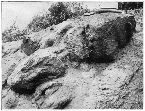
Plate 1.—(a) Granite Weathering to Soil near Northampton, Mass. Under the action of weathering all of the once hard, fresh, mass of granite has crumbled to soil except the fairly fresh rounded masses which are residual cores of “joint blocks.” (Photo by the author.)
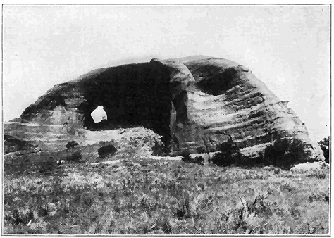
Plate 1.—(b) Looking-Glass Rock, Utah. The rock is stratified sandstone sculptured mainly by wind erosion, that is, by the wind driving particles of sand against it. (Photo by Cross, U. S. Geological Survey.)
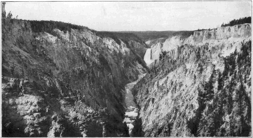
Plate 2.—Grand Canyon of the Yellowstone River in Yellowstone National Park. The great waterfall 308 feet high is shown. The large swift river has here sunk its channel (by erosion) to a maximum depth of 1,200 feet during very recent geological time, and the process is still going on. The wonderful coloring is due to iron oxides set free during weathering of the lava rock. (Photo by Hillers, U. S. Geological Survey.)
Any newly formed land surface, like a recently drained lake bed or part of the marginal sea bottom which has been raised into land, has a drainage system developed upon it. In the early or youthful stage of such a new land area lying well above sea level, under ordinary climatic conditions a few streams only form and these tend to follow the natural or initial slope of the land. These streams carve out narrow, steep-sided valleys, and all of them are actively engaged in cutting down their channels, or, in other words, none of them have reached base level, and flood plains and meandering curves are therefore lacking. During this youthful stage there are no sharp drainage divides; gorges and waterfalls are not uncommonly present; and the relief of the land in general is not rugged. A good example of youthful topography is the region around Fargo, North Dakota, which is part of the bed of a great recently drained lake. The Grand Canyon of the Yellowstone River is an excellent illustration of a youthful valley cut in a high plateau of geologically recent origin. (Plate 2.)
As time goes on, a region in youth gradually gives way to a region in maturity, during which stage the maximum number (usually a network) of streams in broader V-shaped valleys have developed; divisions of drainage are sharp; the maximum ruggedness of relief has developed; the larger streams only have cut down so near base level that winding (meandering) courses and flood plains are well developed along them; and waterfalls and gorges are rarely present. An almost perfect example of a region in maturity is that around Charleston, West Virginia.
The old-age stage develops next in the history of the region, during which only a moderate number of streams remain, most of these being at or close to base level so that sweeping curves or meanders (Plate 4) and cut-off meanders or “ox bows” and wide flood plains are characteristic and common. The relief is greatly subdued and the term “rolling country” might be applied to the moderately hilly region. Divisions of drainage are, of course, not at all sharp and the valleys are wide and shallow. Oxbow lakes are common, but gorges and waterfalls are absent. A region typical of old-age topography is that around Caldwell, Kansas.
Finally, after the remaining low hills have been cut down, the region is in the condition of a broad monotonous plain, practically devoid of relief, over which the sluggish streams pursue very winding, more or less shifting or indefinite courses. For the attainment of this final stage (called a “peneplain”) in the normal cycle of erosion a proportionately very long time is necessary, because the rate of erosion becomes slower and slower as the region is being cut down. Then, too, some change of level between the land and the sea is very likely to take place before the peneplain stage is reached. It is doubtful if any extensive region was ever brought to the condition of a perfect peneplain. Some masses of more resistant or more favorably situated rocks are almost sure to maintain at least moderate heights above the general plain level. Geologically recently upraised, fairly well developed peneplains are southern New England and the great region of eastern Canada. The remarkably even sky lines of these regions mark the peneplain level before the uplift took place, and occasionally masses, called “monadnocks” from Mount Monadnock in southern New Hampshire, rise above the general level. The valleys in such an uplifted peneplain region have been carved out by streams since the uplift began. We have positive evidence that more or less well-developed peneplains of considerable extent existed in various parts of the earth at various times during the many millions of years of known earth history.
The normal cycle of erosion which, as outlined above, tends toward the peneplain condition may be interrupted at any stage by other processes. An excellent case in point is the upper Mississippi Valley, which had reached the old-age stage, even approximating a peneplain, just before the great Ice Age. Then, during the withdrawal of the vast sheet of ice from the region toward the close of the Ice Age, extensive deposits (moraines, etc.) of glacial débris were left irregularly strewn over the country, giving rise to many low hills, lake basins, and altered drainage lines, in some cases with resultant gorge development. Some distinct features of a youthful topography are, therefore, plastered over what was otherwise a region well along in old age. The general district around the Dells of Wisconsin River well illustrates this principle.
Changes in level between land and sea which take place during the erosion of a region may also disturb the normal cycle of erosion. For example, a region in old age may be considerably upraised so that the streams have their velocities notably increased. Such a region is said to be “rejuvenated” and the streams, which are revived in activity, begin to cut youthful valleys in the bottom of the old ones and, after a time, the general surface of the region is subjected to vigorous erosion and a new cycle of erosion will be carried out unless interfered with in some way, as by relative change of level between the land and the sea. In this connection the history of the topography in the general vicinity of Harrisburg, Pennsylvania, may be of interest by way of illustration of the principle just described. The long, narrow, parallel Appalachian Mountain ridges there rise to about the same level, causing a remarkably even sky line as viewed from one of the summits. This even sky line marks approximately the surface of what was a peneplain late in the Mesozoic era. Early in the succeeding Cenozoic era, the broad peneplain was notably upraised to nearly the present altitudes of the ridge tops. The revived Susquehanna River left the old course which it had on the peneplain surface, and began to carve out its present valley, while tributaries (subsequent streams) to it developed along belts of weaker rock and thus they formed the present parallel valleys separated by belts of more resistant rocks which stand out as ridges. In this way, the mature stage of topography was reached. Very recently, geologically, the region has been rejuvenated enough to cause the larger streams to appreciably sink their channels below the general valley floors. The reader will find a general discussion of movements of the earth’s crust in a succeeding chapter.
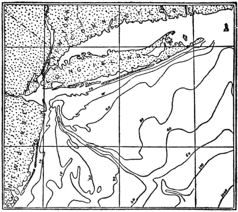
Fig. 1.—The submerged Hudson River channel is clearly shown by the contour lines on the sea floor. Figures indicate depth of water in fathoms. Geologically recent sinking of the land has caused the “drowning” of the river valley. (Coast and Geodetic Survey).
If, for example, a region along the seaboard has reached the mature stage of erosion, and the land notably subsides relative to sea level, the tidewater will enter the lower valleys to form estuaries and the valleys are said to be “drowned.” The large streams, or at least their lower courses, are thus obliterated and also the general erosion of the region is distinctly diminished. The recently sunken coast of Maine well illustrates the idea of “drowned valleys.” The drowned valley of the lower Hudson River is another fine example.
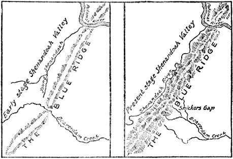
Fig. 2.—Sketch maps showing how the Shenandoah River captured the upper waters of Beaverdam Creek in Virginia. The abandoned valley of the creek across Blue Ridge is now called a “wind gap.” (After B. Willis.)
What is termed stream “piracy” is of special interest in connection with stream work. By this is meant the stealing of one stream or part of a stream by another. We shall here explain only one of the various ways by which stream capture may be effected. One of two fairly active streams, flowing roughly parallel to each other, is more favorably situated and has cut its channel deeper. Its tributaries are, therefore, more favorable to extension of headwaters and, in time, one of its tributaries eats back far enough to tap a branch of the less favorably situated stream so that the waters of this branch are diverted into the more favorably situated stream. The Shenandoah River of Virginia has been such a pirate. This river developed as a tributary of the Potomac. By headward extension toward the south, the Shenandoah finally tapped and diverted the upper waters of the smaller, less favorably situated Beaverdam Creek. The notch or so-called “wind gap” through which the upper waters of Beaverdam Creek formerly flowed across the Blue Ridge is still plainly visible. Such abandoned water gaps, known as “wind gaps,” are common in the central Appalachian Mountain region.
A remarkable type of river is one which has been able to maintain its course through a barrier, even a mountain range, which has been built across it. Thus, the Columbia River, after flowing many miles across the great lava plateau, has maintained its course right across the growing Cascade Range by cutting a deep canyon while the mountain uplift has been in progress. In a similar manner the Ogden River of Utah has kept its westward course by cutting a deep canyon into the Wasatch Range which has geologically recently, though slowly, risen across its path. In no other way can we possibly explain the fact that such a river, rising on one side of a high mountain range, cuts right across it.
A feature of minor though considerable popular interest is the development of “potholes” by stream action. Where eddies occur, in rather active streams, rock fragments of varying sizes may be whirled around in such manner as to corrode or grind the bedrock, resulting in the development of cylinder-shaped “potholes.” Such holes vary in diameter up to fifty feet or more in very exceptional cases. In the production of large “potholes” many rock fragments are worn away and new ones supplied to continue the work. Locally, some stream beds are honeycombed with “potholes.”
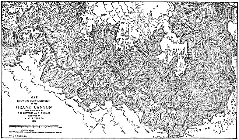
Fig. 3.—Grand Canyon, Arizona. (From Darton’s “Story of the Grand Canyon.”)
Strikingly narrow and deep valleys, called gorges and canyons, are rather exceptional features of stream action. Most wonderful of all features of this kind is the Grand Canyon of the Colorado River in Arizona. In fact, this canyon takes high rank among the most remarkable works of nature. The canyon is over 200 miles long, from 4,000 to 6,000 feet deep, and from 8 to 15 miles wide. Contrary to popular opinion, this mighty canyon is not a result of some violent process, such as volcanic action, or the sudden sinking of part of the earth’s crust. Nor is it the result of the scouring action of a great glacier. It is simply a result of the operation of the ordinary processes of erosion where the conditions have been exceptionally favorable. Some of the favorable conditions have been, and are, a large volume of very swift water (Colorado River) continually charged with an abundance of rock fragments for the work of corrasion, and a great thickness of rock which the river must cut through before reaching base-level. Aridity of climate also tends to preserve the canyon form. The whole work has been accomplished in very late geological time, and the tremendous volume of rock which has been weathered and eroded to produce the canyon has all been carried away by the Colorado River and accumulated in the great delta deposit near where the river empties into the Gulf of California. Even now the canyon is growing deeper and wider because the very active Colorado River is still from 2,000 to 3,000 feet above sea level. Standing on the southern rim near Grand Canyon station at an altitude of nearly 7,000 feet, and looking down into the canyon, one beholds a vast maze of side canyons, high, vertical rock walls which follow very sinuous courses, giving rise to a steplike topography, and countless rock pinnacles, towers, and mesas often of mountain-like proportions. The side canyons are the result of erosion by tributaries to the main river which have gradually developed and worked headward as the main river has cut down. The mountain-like sculptured forms which rise out of the canyon are erosion remnants, or, in other words, masses of rock which were more favorably situated against erosion by either the main river or any of its tributaries. All of the rocks of the broader, main portions of the canyon are strata of Paleozoic age, arranged as a vast pile of almost horizontal layers, including sandstone, limestone, and shale. Some of these layers, being distinctly more resistant than others, stand out in the canyon wall in the form of conspicuous cliffs, in some cases hundreds of feet high. The very striking color bands (mostly light gray, red, and greenish gray), which may be traced in and out along the canyon sides, represent the outcropping edges of variously colored rock layers. Far down in the canyon lies the steep-sided, V-shaped inner gorge, or canyon which is fully 1,000 feet deep. The rocks are there not ordinary strata, but rather metamorphic and igneous rocks, mostly dark gray, not in layers, and about uniformly resistant to erosion. There is reason to believe that this inner gorge has developed mainly since a distinct renewed uplift (rejuvenation) of the Colorado Plateau after the river began its canyon cutting. The narrow, steep-sided inner gorge may thus be readily accounted for and the general lack of steplike forms on its sides is due to essential uniformity of the rock material as regards resistance to erosion.
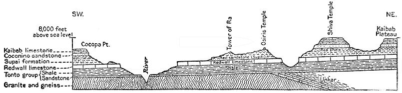
Fig. 4.—Profile and structure section across the line A-A in Fig 3. Length of section 10 miles, vertical scale not exaggerated. The main relief features, and the relations of the rocks below the surface are shown. The granite and gneiss are of Archeozoic age, and the overlying nearly horizontal strata are of Paleozoic age. (After Darton, U. S. Geological Survey.)
The wonderful King’s River Canyon of the southern Sierras in California is remarkable for its combined narrowness and depth. It is a steep V-shaped canyon whose maximum depth is 6,900 feet, carved out in mostly solid granite by the action of weathering and running water. Some idea of the vast antiquity of the earth may be gleaned from the fact that this tremendously deep canyon has been produced by erosion in one of the most resistant of all known rocks in very late geologic time! Conditions favorable for cutting this canyon have been volume and swiftness of water and a liberal supply of grinding tools.
Among the many other great canyons of the western United States brief mention may be made of the Grand Canyon of the Yellowstone River in the National Park. The plateau into which the river has cut its steep-sided, narrow, V-shaped canyon, with a maximum depth of 1,200 feet, has been geologically recently built up by outpourings of vast sheets of lava. The large volume of very swift water, aided by decomposition and weakening of the ordinarily very hard rock by the action of the hot springs, has been able to carve out this deep canyon practically within the last period of earth history. The deepening process is still vigorously in progress. The wonderful coloring of the rock, mostly in tones of yellow and brown, is due to the hydrated iron oxides developed during the decay of the iron-bearing minerals of the lava, the chemical action having been greatly aided by the action of the hot waters. (See Plate 2.)
In regard to its origin, the marvelous Yosemite Valley, or canyon, falls in a somewhat different category, and it is discussed beyond in connection with the work of ice. Suffice it to say here that running water has been a very important factor in its origin.
In New York and New England there are many gorges which have developed by the action of running water since the Great Ice Age. Famous among these are Ausable Chasm and Watkins Glen of New York, and the Flume in the White Mountains of New Hampshire.
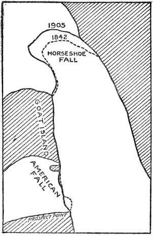
Fig. 5.—Sketch map showing the retreat of the crest of Niagara Falls from 1842 to 1905, based upon actual surveys. The retreat of the inner part of the Horseshoe Fall was more than 300 feet. (Modified by the author after Gilbert, U. S. Geological Survey.)
Before leaving our discussion of the work of running water, we should briefly consider waterfalls. True waterfalls originate in a number of ways. Most common of all is what may be termed the “Niagara type” of waterfall. Niagara Falls merit more than passing mention not only because of their scenic grandeur, but also because of the unusual number of geologic principles which their origin and history so clearly illustrate. Niagara Falls are divided into two main portions, the Canadian, or so-called “Horseshoe Fall,” and the “American Fall,” separated by a large island. The crest of the American Fall is about 1,000 feet long and nearly straight, while the crest of the Canadian Fall is notably curved inward upstream, and it is about 3,000 feet long. The height of the Falls is 167 feet. Downstream from the Falls there is a very steep-sided gorge about 200 feet deep and seven miles long. The exposed rocks of the region are nearly horizontal layers of limestone underlain with shales. Relatively more resistant limestone forms the crest of the falls, and directly underneath are the much weaker shales. Herein lies the principle of this type of waterfall because, due to weathering and the swirling action of the water, the weaker underlying rocks erode faster, thus causing the overlying rock to overhang so that from time to time blocks of it already more or less separated by cracks (joints), fall down and are mostly carried away in the swift current. Thus the waterfall maintains itself while it steadily retreats upstream. Careful estimates based upon observations made between 1827 and 1905 show that the Canadian Fall retreated at the rate of from three to five feet per year, while the American Fall retreated during the same time at the rate of only several inches per year. It has been well established that Niagara Falls came into existence soon after the ice of the great Ice Age had retreated from the district. The falls started by plunging over a limestone escarpment, situated at what is now the mouth of the gorge seven miles downstream from the present falls. If we consider the rate of recession of the falls to have been always five feet per year, the length of time required to cut the gorge would be something over 7,000 years. But the problem is not so simple, because we know that, at the time of, or shortly after, the beginning of the falls, the upper Great Lakes drained farther north and not over the falls; and that this continued for a considerable, though unknown, length of time. During this interval the volume of water in Niagara River was notably diminished, and hence the recession of the falls must have been slower. On the other hand, judging by the width of the gorge, the length of the crest of the falls has generally been considerably less than at present, which in turn means greater concentration of water over the crest and more rapid wear. Various factors considered, the best estimates for the age of the falls vary from 7,000 to 50,000 years, an average being about 25,000 years. Although this figure is not precise, it is, nevertheless, of considerable geologic interest because it shows that the age of Niagara Falls (and gorge) is to be reckoned in some tens of thousands of years, rather than hundreds of thousands or millions of years. Although waterfalls of the Niagara type are the most common of all, it is by no means necessary that the particular rocks should be limestone and shale.
Another common kind of waterfall may be termed the “Yosemite type,” so named from the high falls in the Yosemite Valley of California. At the great falls of the Yosemite, the rock is a homogeneous granite and the undermining process does not operate. Yosemite Creek first plunges vertically over a granite cliff for 1,430 feet to form the Upper Falls, which must rank among the very highest of all true water falls. The water then descends about 800 feet by cascading through a narrow gorge, after which it makes a final vertical plunge of over 300 feet. A brief history of the falls is about as follows. A great steep-sided V-shaped canyon several thousand feet deep had been carved out by the action of the Merced River which now flows through the valley. Then, during the Ice Age, a mighty glacier plowed through the canyon, filling it to overflowing. The granite of this district having been unusually highly fractured by great vertical joint cracks was relatively easy prey for ice erosion. Due to its great weight, the erosive power of the ice was most potent toward the bottom, successive joint blocks were removed, and the valley was thus widened and the sides steepened or even commonly made practically vertical. (See Plate 6.) After the melting of the ice, certain of the streams, like Yosemite Creek and Bridal Veil Creek, were forced to enter the valley by plunging over great perpendicular, granite cliffs which are in reality joint faces. This type of waterfall does not retreat, but it constantly diminishes in height by cutting into the crest. A number of other high falls of this kind occur in the Yosemite region, and also in other mountain valleys which formerly contained glaciers, as in the Canadian Rockies, the Alps, and Norway, the rocks in these regions being of various kinds.
In the case of the “Yellowstone type” of waterfall a different principle is involved, namely, a distinctly harder or more resistant mass of rock which extends vertically across the channel of the stream. At the Great Falls of the Yellowstone a mass of relatively fresh, hard lava lies athwart the course of the river, while just below it the lava has been much weakened by decomposition. The harder rock therefore acts as a barrier, while, in the course of time, the weak rock on the downstream side has been worn away until a waterfall 308 feet high has developed. This waterfall does not retreat very appreciably, but it is probably increasing in height, due both to the scouring action of the water at the base of the fall and the unusual clearness of the river water here, thus causing little wear at the crest. It should be noted, in this connection, that the channel just on the upstream side of the barrier cannot be cut down faster than the top of the barrier itself.
The famous Victoria Falls of the Zambezi River in South Africa, represents a relatively uncommon type of waterfall. Considering height of the fall, length of crest, and volume of water, this is perhaps the greatest waterfall in the world. The Zambezi River, a mile wide, plunges over 400 feet vertically into a chasm only a few hundred feet wide and at right angles to the main course of the stream. The general country rock is hard lava, but locally a narrow belt of the rock has been highly fractured vertically, due to earth movements or faulting (see explanation beyond) and therefore weakened and more subject to weathering than the general body of the lava rock. This belt of weakened rock has been easy prey for erosion by the Zambezi River and the chasm has there developed. In fact the chasm is still being increased in depth. Leaving the chasm toward one end, the river flows through a narrow zig-zag gorge whose position has been determined by big joint cracks. The mile-wide crest of the falls is interrupted by a good many ledges and even small islands. The thundering noise of this great waterfall is most impressive, but a good complete view is impossible because most of the chasm is constantly filled with dense spray.
Still another type of waterfall develops by the removal of joint blocks by the action of running water. Falls of this type are fairly common though they seldom attain really great heights. Where the rock in the bed of a stream is traversed by well-developed vertical joint cracks, slabs of rock cleaved by the joints may fall away due to weathering or they may be pushed away by pressure of the water. Such a fall retreats upstream by removal of joint blocks even in comparatively homogeneous rocks. Taughannock Falls, 215 feet high, in southern central New York, has developed by this manner in a shaly sandstone. The several falls (one 50 feet high) in the famous gorge at Trenton Falls, in central New York, have developed in this way in limestone.
CHAPTER IV
THE SEA AND ITS WORK
I
IT is well known that the waters of the sea cover nearly three-fourths of the surface of the earth. We think of the United States as being a large piece of land of over three million square miles—but the sea is about forty-five times as large, that is, it covers approximately 140,000,000 square miles. It is a remarkable fact that the average depth of the great oceans of the earth is nearly two and one-half miles. If the sea were universally present everywhere with the same depth, it would be almost two miles deep. Yet this vast body of water is an extremely thin layer when compared with the earth’s diameter of 8,000 miles. The Pacific is the deepest of the oceans with an average depth of about two and three-fourths miles. The deepest ocean water ever sounded is 32,114 feet (over six miles), not far from the Philippine Islands. This is known as the Planet Deep, and was discovered in 1912. Second deepest is 30,930 feet near the island of Guam. In the Pacific Ocean there are five places where the water is over five miles deep and eleven places were it is over four miles deep. The deepest sounding ever made in the Atlantic Ocean was 27,972 feet, not far from Porto Rico.
Many substances are known to be in solution in sea water, but in spite of this the composition is remarkably uniform. The most abundant substance by far in solution is common salt. In every 100 pounds of sea water, there are 3.5 pounds of mineral matter of various kinds dissolved. Nearly 78 per cent of the dissolved matter is common salt. The principal other constituents in solution are chloride and sulphate of magnesia, and the sulphates of lime and potash. All other dissolved mineral substances together make up less than one per cent of the total. It has been estimated that if all the dissolved mineral matter should be brought together, it would form a layer 175 feet thick over the whole sea bottom. The salts of the sea have been mostly supplied by the rivers, which in turn have derived them from the disintegration and chemical decay of the rocks.
If we make a general comparison with the surface of the land, the floor of the ocean is a vast monotonous plain. None of the sea bottom compares with the ruggedness of mountains, and even the more level portions of land surface show many sharp minor irregularities such as stream trenches. But the sea bottom is characterized by its smoothness of surface. There are under the sea, however, mountain-like ridges, plateaus, submarine volcanoes and valleys known as “deeps.” But these rarely show ruggedness of relief like similar features on land.
One of the most remarkable relief features of the ocean bottom is the so-called “continental shelf.” This is a relatively narrow platform covered by shallow water bordering nearly all the lands of the earth. Seaward, the depth of water is greatest, and it is seldom over 600 or 800 feet. The continental shelves of the world cover about 10,000,000 square miles or about one-fourteenth of the area of the sea.
Viewed in a broad way, there are two great classes of marine deposits; first, those laid down comparatively near the borders of the land, that is, on the continental shelf and continental slope, and second, the abysmal deposits laid down on the bottom of the deep ocean. Those found along and near the continental borders are largely land-derived materials, that is to say, they are mostly sediments carried from the land into the sea by rivers, and to a lesser extent rock material broken up by waves along many shores. Practically all such land-derived material is deposited within 100 to 300 miles of the shores. The continental border deposits are extremely variable. Near shore they are chiefly gravel and sands, while farther out they become gradually finer, and on the continental slope only very fine muds are deposited. These deposits usually contain more or less organic materials and shells or skeletons of organisms. In some cases the shells or skeletons of organisms predominate or even exist to the exclusion of nearly all other material, as is true of the coral deposits or reefs which form only in shallow water. Deposits like those just described as accumulating on the bottom of the shallow sea, comparatively near the lands, are of great significance to the geologist because just such marine deposits now consolidated into sandstone, conglomerate, shale, and limestone, are so widely exposed over the various continents. A knowledge of the conditions under which shallow sea deposits are now forming, is, therefore, of great value in interpreting events of earth history as they are recorded in similar rocks which have been accumulating through millions of years of time. One specific instance will make this matter clearer. Using the method outlined in Chapter I for the determination of earth chronology, and our knowledge of present conditions under which shallow sea deposits are formed, it has been well established that a shallow sea spread over fully four-fifths of the area of North America during the middle Ordovician period of the early Paleozoic era. Beyond this main conclusion, a careful study of these rocks has revealed many important facts regarding the physical geography, life, and climate of that time. The importance of this whole matter is still further emphasized by the statement that five-sixths of the exposed rocks of the earth are strata—mostly of shallow sea origin.
The deposits on the deep sea bottom are very largely either organic or the shells and skeletons of organisms which have fallen to the bottom from near the surface as already explained. Most common of these are the deep sea “oozes” which are made up of the remains and shells of tiny organisms called “foraminifers.” These “oozes” cover about 50 million square miles of the sea bottom down to depths of from two to three miles.
At depths greater than from two to three miles, a peculiar red clay is the prevailing deposit. This is most extensive of all, covering an area of 55 million square miles, or nearly the total area of lands of the earth. Some remains of organisms are mixed with this clay, but since most of the shells are of carbonate of lime and very thin, they are dissolved without reaching the bottom in the deep sea water which is under great pressure and rich in carbonic acid gas.
The deep sea deposits, both “oozes” and red clay, do, however, contain some land-derived and other materials. Thus off the west coast of Africa some dust carried by the prevailing winds from the Sahara Desert, is known to fall in the deep sea several hundred miles from shore. Volcanic dust is carried for many miles and deposited in the deep sea—particularly in the South Pacific Ocean. Bits of porous volcanic rock called “pumice” sometimes float long distances out over the deep sea, before becoming water soaked. Icebergs often drift far out from the polar regions over the deep sea, and on melting the rock débris which they carry is dropped to the sea bottom. Also, particles of iron and dust from meteorites (“shooting stars”) have been dredged from the deep sea.
One important geological significance of the deep sea deposits is the proof which they furnish that, from at least as far back as the beginning of the Paleozoic era, fully twenty-five million years ago, to the present time, the two great deep ocean basins—the Atlantic and the Pacific—have maintained essentially the same positions on the earth. This is proved by the fact that nowhere, on any continent among the rocks of all ages, as old at least as the early Paleozoic, do we find any really typical deep-sea deposits. There is then no evidence that a deep sea ever spread over any considerable part of any continent, and this in spite of the fact that marine deposits of shallow water origin furnish abundant evidence of former sea extensions. The shallow seas have at various times spread over large portions of the continents.
On many rocky coasts the waves are incessantly pounding and wearing away the rocks. In such places the sea, like a mighty horizontal saw, is cutting into the borders of the lands. The finer materials produced by the grinding up of the rocks are carried seaward by the undertow. But, if the land remains stationary with reference to the sea, this landward cutting by the waves reaches a limit. Since even big waves have very little effect in water 100 or 200 feet deep, a shelf is cut by the waves and this shelf, not many miles wide, is covered by shallow water. The finer ground-up rock materials carried out by the undertow are dumped just beyond the edge of the shelf which is thus built out seaward as a terrace. In traveling over this shelf and terrace, the waves, due to friction, lose their power. With gradually sinking land, a much wider shelf may be cut, because the power of the waves is then allowed to continue.
It might be of interest to cite a few cases of relatively rapid coast destruction by the waves which have come under human observation. A remarkable example is the island of Heligoland on which is (or was) located the powerful German fort which guards the entrance to the Kiel Canal. In the year 800 A. D. this island had 120 miles of shore line; in 1300 it had 45 miles of shore; in 1649 only 8 miles; and in 1900 but 3 miles of shore line remained. In southeastern England “whole farms and villages have been washed away in the last few centuries, the sea cliffs retreating from 7 to 15 feet a year.” A church located a mile from the sea shore near the mouth of the Thames river, in the sixteenth century, now stands on a cliff overlooking the sea. An island in Chesapeake Bay covered over 400 acres in 1848, and the waves have since reduced it to about fifty acres. Study showed that the relatively soft unconsolidated strata of the Nashaquitsa Cliffs on the island of Martha’s Vineyard, were cut back at the rate of 51/2 feet per year, between 1846 and 1886.
If part of the relatively smooth sea bottom should be raised into land, the resulting shore line would of course, be regular and free from indentations or sharp embayments. Examples of such coast which are very young are at Cape Nome, Alaska; the northern coast of Spain; and the west coast of northern South America. Soon, however, such a shore line is attacked, and, either where the waves are greatest or the rocks are weakest, indentations will result and the whole coast is gradually eaten back until the power of the waves is largely spent in traveling across the shallow water shelf. Sand bars are then built across the mouths of the bays or indentations which later the rivers gradually fill up with sediment. The result is a relatively straight or regular old shore line. The coast of Texas has about reached this stage.
If a portion of the relatively rugged land surface should become submerged under the sea, a very irregular, deeply indented shore line would result, due to the entrance of tidewater into the valleys. The deeply indented coast of Maine is a fine example of a very irregular youthful shore line produced by geologically recent sinking of a rugged, hilly region so that tidewater backs for miles into the lower reaches of the river valleys. The promontories and islands are undergoing rapid wear, and the development of bars across the inlets has scarcely begun. Other excellent examples are the coasts of Norway and southern Alaska. Such a coast is then attacked by the ocean waves and the promontories are cut back until the broad shallow water shelf is formed, after which sand bars are built across the remaining embayments and the shore line becomes relatively regular.
It is, then, a remarkable fact that, whether shore lines originate by emergence of sea bottom, or by sinking of land, there is a very strong tendency on the part of nature to develop regular shore lines. It should be stated that the principles of wave work and shore-form development just outlined apply almost equally well to lakes, especially large ones.
Before leaving this subject of shore-line development, mention should be made of the fact that bars and beaches are often built part way or wholly across embayments of the coast with surprising rapidity. To illustrate, Sandy Hook, New Jersey, is advancing northward, while Rockaway Beach, New York, is extending westward, the tendency being to close up the entrance to New York harbor and to make the line of seashore more nearly regular. Records show that Rockaway Beach actually advanced westward more than three miles between the years 1835 and 1908.
CHAPTER V
GLACIERS AND THEIR WORK
A
A GLACIER may be defined as a mass of flowing ice. The motion may not be that of flowage in the usually accepted sense of the term. A discussion of the various theories of glacier motion will not here be attempted. Glaciers form only in regions of perpetual snow, but they commonly move down far below the line of perpetual snow of any given region. In the polar regions they may form near sea level, while in the tropics they form at altitudes of two to three miles, and there only rarely. In southern Alaska, the lower limit of perpetual snow is about 5,000 feet above sea level, and many of the glaciers come down to sea (Plate 4), while in the Alps, the lower limit of perpetual snow is at about 9,000 feet, and the glaciers descend as much as 5,000 feet below it.
In regions of perpetual snow there is a tendency for more or less snow to accumulate faster than it can be removed by evaporation or melting. As such snow accumulates it gradually undergoes a change, especially in its lower parts, first into granulated snow (so-called “névé”) and then into solid ice. Snow drifts in the northern United States often undergo similar transformation, after a few months first to névé, and then to ice. This transformation seems to be brought about mainly by weight of overlying snow which compacts the snow crystals; by rain or melting snow percolating into the snow to freeze and fill spaces between the snow crystals; and by the actual growth of the crystals themselves. When ice of sufficient thickness has accumulated (probably at best several hundred feet), the spreading action or flowage begins and a glacier has developed. Renewed snowfalls over the gathering ground keep up the supply of ice.
There are several types of glaciers: valley or alpine glaciers; cliff or hanging glaciers; piedmont glaciers; ice caps; and continental ice sheets. A valley or alpine glacier consists essentially of a stream of ice slowly flowing down a valley and fed from a catchment basin of snow within a region of perpetual snow. In the Alps, where glaciers of this sort are very typically shown, they vary in length up to eight or nine miles. Perhaps the grandest display of great valley glaciers is in southern Alaska where they attain lengths up to forty or fifty miles and widths of one or two miles (Plate 4).
Hanging or cliff glaciers are in many ways like valley glaciers, but they are generally smaller; they develop in snow-filled basins above the snow line usually on steep mountain sides; and they do not reach down into well-defined valleys. Most of the glaciers of the Glacier National Park in Montana and many of those in the Cascade Mountains are of this type. Mount Rainier in Washington is one of the most remarkable single large mountain peaks in the world, in regard to development of glaciers over it. Great tongues of ice, starting mostly at 8,000 to 10,000 feet above sea level, flow down the sides of the mountain for distances of to four and even six miles. The total area of ice in this remarkable system of radiating glaciers on this one mountain is over forty square miles. These Mount Rainier glaciers are in general best classified as intermediate in type between valley and hanging glaciers.
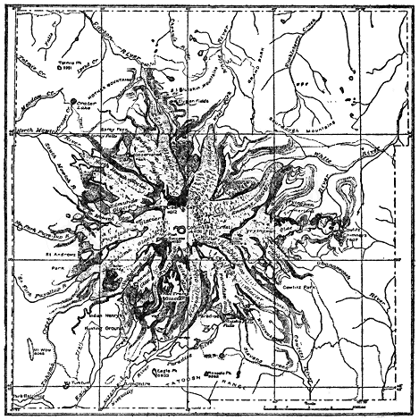
Fig. 6.—Map of Mount Rainier, Washington, showing its wonderful system of glaciers which covers more than 40 square miles. Dotted portions represent moraines. (U. S. Geological Survey.)
In some high latitude areas, as in Iceland and Spitzbergen, snow and ice may accumulate on relatively level plains or plateaus and slowly spread or flow radially from their centers. These are called ice caps. Ordinary ice caps usually do not cover more than some hundreds of square miles.
Continental glaciers or ice sheets are, in principle, much like ice caps, but they are larger. Greenland is buried under an ice sheet of moderate size (about 500,000 square miles), the motion being outward in all directions toward the sea. Tongues of ice, like valley glaciers, are commonly sent off from the main body of ice across the land border of Greenland into the sea. The size of the great ice sheet of Antarctica is not definitely known, but it covers probably at least several million square miles. Two continental ice sheets of special interest to the geologist are those which existed during the great Ice Age of the Quaternary period. One of these then covered nearly 4,000,000 square miles of North America, while the other covered about 600,000 square miles of northern Europe. The main facts regarding the Ice Age are given in a succeeding chapter. The facts brought out in the present discussion of existing glaciers will greatly aid in understanding the Ice Age.
How fast do glaciers flow? Based upon many observations, we may say that an average rate of flow for the glaciers of the world is not more than a few feet per day. A very exceptional case is a large glacier, branching off as a tongue from the ice sheet of Greenland, which is said to move sixty to seventy-five feet per day. Some of the great Alaskan glaciers have been found to flow from four to forty feet per day. Most glaciers of the Alps move only one to two feet per day. A glacier advances only when the rate of motion is greater than the rate of melting of its lower end and vice versa in the case of retreat. Thus it is true, though seemingly paradoxical, to assert that a glacier has a constant forward motion even when it is retreating by melting.
By watching the changing position of marked objects placed in the ice, it has been proved that, in a valley glacier, the top moves faster than the bottom; the middle moves faster than the sides; the rate of motion increases with thickness of ice, slope of floor over which it moves, and temperature.
Ice, like molasses candy, tends to crack when subjected to a relatively sudden force, and where the ice rides over a salient on the bed of the glacier, transverse cracks or fissures often develop. Due to more rapid motion of the central part of a valley glacier, stresses and strains are set up and crevasses are formed, usually pointing obliquely upstream. Where the ice tends to spread laterally in a broad portion of a valley, longitudinal cracks may develop. Crevasses vary in size up to several feet in width and hundreds of feet in depth. Owing to the forward motion of the ice, old fissures tend to close up and new ones form, and, aided by uneven melting, the surface of a glacier is generally very rough.
Like running water, ice may have considerable erosive power when it is properly supplied with tools. The total erosive effect which has been, and is now being, accomplished by ice compared with that of running water is, however, slight. One of the main processes by which ice erosion is accomplished is “corrasion” due to the rubbing or grinding action of hard rock fragments frozen into the bottom and sides of the glacier. Thick ice, shod with hard rock fragments and flowing through a deep, narrow valley of soft rock, is especially powerful as an erosive agent because the abrasive tools are supplied; the work to be done is easy; and the deep ice causes great pressure on the bottom and lower sides of the valley. Rock surfaces which have been thus subjected to ice erosion are characteristically smoothed and more or less scratched, striated, or ground due to the corrosive effects of small and large rock fragments. This affords one of the best means of proving the former presence of a glacier over a region or in a valley. A typical V-shaped stream cut (eroded) valley is changed into one with a U-shaped profile or cross section by glacier erosion (Plate 5).
Another important process of ice erosion is “plucking,” which consists in pushing among already more or less loosened joint blocks by the pressure of the moving ice. The pressure thus exerted, especially by a deep valley glacier, may be enormous. This process was an important factor in the development of the famous Yosemite Valley, a very brief account of whose history it will now be instructive to give.
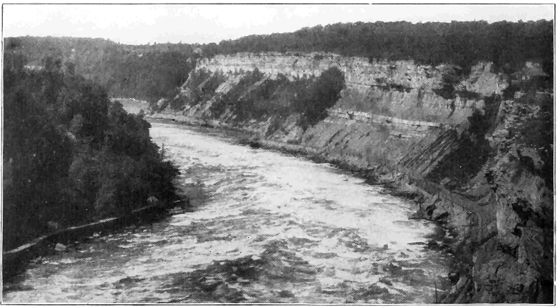
Plate 3.—The Gorge of Niagara River Below the Great Falls. The strata (containing fossils) were accumulated on the bottom of the Silurian sea which overspread the region at least 18,000,000 years ago. Since the Ice Age or within 20,000 to 40,000 years, the river has carved out the gorge. (Courtesy of the Haines Photo Company, Conneaut, Ohio.)
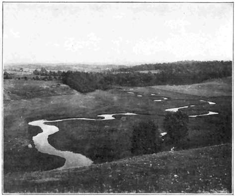
Plate 4.—(a) A Winding Stream in the St. Lawrence Valley of New York. Due to its low velocity the stream cuts its channel down very little, but it swings or “meanders” slowly from one side of its valley to the other, developing a wide flood plain. The stream once flowed against the valley wall shown at the middle left. (Photo by the author.)
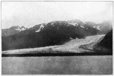
Plate 4.—(b) Davidson Glacier, Alaska. This glacier is at work slowly grinding down the valley floor and cutting back its walls, thus changing the original stream-cut, V-shaped profile, like that of Plate 5. (Photo by Wright, U. S. Geological Survey.)
The Yosemite Valley, about 7 miles long, less than one mile wide, and from 2,000 to 4,000 feet deep, lies on the western slope of the Sierra Nevada Mountains of California. Great cliffs of granite, mostly from 1,000 to over 3,000 feet high, bound the valley on either side. The floor of the valley is wide and remarkably flat (Plate 6). Just prior to the Ice Age, by the processes of erosion already set forth, the Merced River had carved out a great steep-sided V-shaped canyon commonly from 1,000 to 3,000 feet deep. During the Ice Age, two glaciers joined to form an extra deep powerful glacier, which flowed through a deep part of the Merced Canyon and modified it into the Yosemite Valley, essentially as we see it to-day. Because the ice was shod with many fragments of hard rock (granite), and the pressure at the bottom and lower sides of the glacier (several thousand feet thick) was so great, the V-shaped stream-cut canyon was changed to a U-shaped canyon with very steep to even vertical walls. A factor of great importance which notably aided the erosive power of the glacier in this case was the existence of an unusual number of large vertical joint cracks in the granite in this local region. The plucking action of the ice was thus very greatly facilitated and great slabs of rock, separated by the vertical joints, especially toward the lower sides and bottom of the valley, were pushed away one after another by the ice. When the ice disappeared, great precipitous joint faces from 1,000 to 3,000 feet high were left along the valley sides. At its lower end the glacier left a dam of glacial débris (moraine) across the valley, thus causing a lake to form over the valley floor. The wide flat bottom of the valley was caused by filling up of the lake with sediment. The uniqueness of the Yosemite Valley is, then, due to a remarkable combination of several main factors; one, the presence of a large swift river well supplied with tools which carved out a deep V-shaped canyon; two, a mighty glacier which plowed its way through this canyon and converted it by erosion into a U-shaped canyon; three, the weakening of the rock by many joint cracks, thus greatly facilitating the ice erosion; and four, a postglacial lake covering the valley floor which became filled with sediment. As a result of the ice work, several streams, tributary to the main stream (Merced River) which flows through the bottom of the valley, were forced to plunge over great vertical rock walls (joint faces), thus producing high and beautiful true waterfalls, including the very high Upper Yosemite Fall where Yosemite Creek makes a straight drop of 1,430 feet. A tributary valley like that of Yosemite Creek, which ends abruptly well above the main valley, is known as a “hanging” valley. The valley of Bridal Veil Creek is another good example. (See Plate 6.) Valleys which were once occupied by active glaciers are generally characterized by their U-shaped cross sections and their hanging (tributary) valleys, but the great height and steepness of the valley walls in Yosemite are exceptional.