Front matter (continued 3)
Reading edition
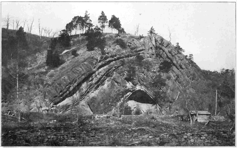
Plate 7.—An Upbend Fold (anticline) in the Appalachian Mountain Strata Near Hancock, Maryland. The strata were deposited in horizontal layers upon the sea bottom, covering the region many millions of years ago in middle Paleozoic time. At the time of the Appalachian Mountain revolution, near the end of Paleozoic time, this and many other folds developed well below the surface. Removal of overlying material by erosion has laid bare the fold as we see it to-day. (Photo by Russell, U. S. Geological Survey.)
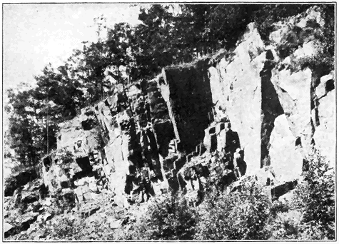
Plate 8.—(a) A Ledge of Igneous Rock (Granite) in Northern New York. This illustrates so-called “joints” or natural cracks, commonly separating most hard rock masses into more or less prismatic blocks. (Photo by the author.)
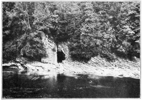
Plate 8.—(b) A Fault Fracture in a Ledge at East Canada Creek in the Mohawk Valley, New York. The Ordovician limestone formation in thin layers on the right has sunk hundreds of feet along vertical fault to the left of middle, bringing it sharply against the older (Cambrian) massive formation on the left. The hole is artificial. (Photo by Darton, U. S. Geological Survey.)
Geysers are periodically eruptive hot springs found only in a few of the volcanic regions of the world. They are most wonderfully displayed in the Yellowstone National Park, where they send columns of hot water to all heights up to 250 feet at various intervals of time. Almost incredible amounts of hot water are sent into the air every day in the geyser basins of Yellowstone Park. The single geyser “Old Faithful,” which erupts at intervals of about seventy minutes, sends a column of water several feet in diameter to heights of from 125 to 150 feet. During each eruption about 1,500,000 gallons of water are sent forth, or every day enough to supply the need of a fairly large city. A very brief explanation of the cause of geyser eruptions may be stated as follows: The very irregular, narrow, geyser tube extends nearly vertically downward into yet uncooled lava. The tube is more or less rapidly filled by underground water. The bottom, or near-bottom, portion of the water gradually becomes heated by the lava until finally the boiling point is reached for that depth. But, because of the pressure of the overlying water column, the boiling point at that depth is considerably greater than for the surface. A little steam develops far down and this causes the whole column of water above it to lift slightly, thus relieving the pressure on the superheated water far down. This relief of pressure allows much of the superheated water far down to flash into steam, which violently forces the column of water out of the geyser tube.
CHAPTER X
HOW MOUNTAINS COME AND GO
M
MOUNTAINS constitute the grandest relief features of the earth, and some of the most profound lessons of earth changes may be learned by studying them. To the layman who views great mountains in all their grandeur and massiveness, the expression “everlasting hills” seems appropriate. But the geologist knows that even the loftiest mountains are only temporary features on the face of the earth. Like organisms, they come and go. For example, where the great Rocky Mountains now stand was only a few million years ago (in late Mesozoic time) the bottom of an interior sea. Where the Appalachians now stand there were no mountains late in the Paleozoic era (not less than ten or twelve million years ago), but instead sea water covered the district. Then the Appalachians were formed, lifting their heads much higher than at present, after which they were cut down almost to sea level, and then once more upraised. The Coast Range Mountains of our Pacific Coast have come into existence since the middle of the present (Cenozoic) geologic era. Every mountain, like every organism, has a life history, in some cases simple, and other cases complex. All pass through stages of birth, youth, maturity, old age, and death. Some rear their heads and disappear after a short (geological) existence. Others continue their growth and persist much longer, while still others undergo periods of profound rejuvenation.
Among the various processes by which mountain ranges have been formed, the folding and accompanying general uplift of strata are the most important. In fact, in most of the great mountain ranges of the world the folded structure is conspicuously developed, so much so that they may well be called “folded mountains.” Very commonly, however, mountains of this type have also been subjected to more or less fracturing of the rocks (faulting), and not uncommonly they have also been subjected to igneous activity, including both intrusion and extrusion of molten material. It is among the folded mountains of greater or less degree of complexity that the “greatest exhibitions of geologic phenomena are seen and the lessons which geology as a sciences teaches may be learned. If one desires to know the history of a region, one turns naturally to its mountain ranges, for here may be found the upturned and dissected strata, a study of whose kinds, thickness, and fossils throws light upon past events, while their foldings and dislocations show the nature and results of those great dynamic agencies which, from time to time, have operated upon the outer portion of the earth, and given to it the broad distinctive features which characterize it to-day.” (L. V. Pirsson.) Among the great mountains we may also see wonderful exhibitions of the results of weathering and erosion, especially the work of rivers and glaciers.
We can, perhaps, best convey to the reader some of the main facts and principles regarding folded mountains by considering certain observations which may be readily made in a short trip across a folded range of not too complex kind—for example, across the Appalachian range along the line of the Baltimore and Ohio Railroad, west of Washington, or the Pennsylvania Railroad, west of Philadelphia. It would be most evident that the mountains consist of strata, that is sedimentary rocks, such as sandstone, shale and limestone, which were deposited under water. A few measurements would reveal the fact that thousands of feet in thickness of strata are represented. Careful measurements by geologists have, in fact, shown that the strata were originally piled up layer upon layer to a thickness of 25,000 to 30,000 feet. The fact that they are strata of such great thickness proves that sediments must there have accumulated under water for some millions of years at least. Closer examination of a few good exposures (i.e., outcrops) would further reveal the presence of fossil shells and impressions of marine organisms, thus definitely leading us to conclude that the strata were accumulated under sea water, which, of course, means that the present site of the mountain range was once sea floor.
Examination of the rock materials also establishes the fact that the strata are such as were deposited in relatively shallow sea water—that is to say, none are at all of the sort which are now forming under really deep ocean water. Most of the strata represent original sands (and even gravels) and muds which could have accumulated only relatively near shore, that is within about 100 miles, which harmonizes with a statement made in a preceding chapter to the effect that very little land-derived sediment is at present depositing more than 100 miles out from shore. The coarse materials (sands and gravels) could not, of course, be carried many miles out, while many of the strata are covered with ripple marks, thus positively proving their shallow-water origin. We conclude, therefore, that the Appalachian strata are of marine, shallow-water origin. But we have already stated that these strata are at least 25,000 feet thick. How, then, do we reconcile these two seemingly paradoxical statements? All that is necessary is to realize that the floor of the shallow sea, in which the sediments eroded from adjacent land were being deposited, slowly, though more or less irregularly, subsided or sank during the long ages (millions of years) of their accumulation. It would carry us too far afield to really attempt an explanation of this remarkable type of geologic phenomenon, and it must suffice to suggest that, starting with the earth’s crust in equilibrium, the very weight of accumulating strata would tend to destroy that equilibrium and so cause subsidence.
In our trip across the mountains it would be strikingly evident that the strata are no longer in their original horizontal position, as they were piled up layer upon layer, but that they have been notably disturbed and thrown into folds (Plate 7), large and small, some masses of the strata having been bent upward (anticlines) and others downward (synclines). Such folded structures could have been developed only by a great force of lateral compression in the earth’s crust within the zone of flowage. Under compression the strata were mashed together, notably bent into curves (folds), and more or less upraised. It would also be readily observed that the main axes of the folds extend essentially parallel to the main trend of the mountain range, thus proving that the force of compression was exerted at right angles to the trend of the range.
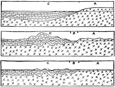
Fig. 24.—Diagrammatic sections illustrating the development of a typical folded mountain range. Upper figure: A, the old land eroded to furnish sediments deposited under the adjacent sea at C. Middle figure: strata (C) folded as they would appear if unaffected by erosion, and a down-warp (B) between A and C. Lower figure: condition after profound erosion, and filling of B with sediment. (Drawn by the author.)
Using a biological analogy, a brief history of a typical folded mountain range may be stated as follows: First, there is the prenatal or embryonic stage when the materials of the range are gathering, that is when the sediments are piling up layer upon layer relatively near shore on a sinking sea bottom. Next comes the birth of the range when, due to the great lateral compressive force, the strata are thrown into folds and forced to appear above sea level, the range thus literally being born out of the sea. During the next, or youthful stage, the range grows (with increasing altitudes) because of continued application of the compressive force. Even during the youthful growing stage weathering and erosion attack the range and tend to reduce it. Then comes the stage of maturity, when the upbuilding (compressive) force and the tearing down (erosive) force about counterbalance each other. At this time the range has reached its maximum height and ruggedness of relief, with ridges and valleys higher and deeper than at any other time. The old-age stage sets in when the upbuilding power wanes or actually ceases, and erosion dominates or reigns supreme. Slowly but surely, unless there be a renewal by an upbuilding power, the range is cut down until little or nothing of it remains well above sea level, or, in other words, until a peneplain is developed. This last stage may truly be called the death of the range. Usually, however, some local portions of the disappearing range, which are more resistant or more favorably situated against erosion, are left standing to at least moderate heights above the general level of the plain of erosion.
The above normal order of events may be disturbed at any stage, especially after maturity, by renewed uplift when the streams are revived in activity and increased ruggedness results. Even after the whole range as a relief feature has been planed away, the site of the range may be uplifted and a new cycle of erosion started.
By the use of two well-known examples we shall not only illustrate the above principles of mountain history, but also show that no less than a few million years must be allowed for the growth and decay of a great folded range. During the last (Permian) period of the Paleozoic era the Appalachian strata began to buckle and the yielding to pressure continued till well into the succeeding (Triassic) period. The climax was reached about the close of the Permian. Then, throughout the Mesozoic era, erosion reduced the central Appalachians to a great plain (peneplain) near sea level, after which, about the beginning of the present (Cenozoic era), the site of the former range was distinctly upraised (without folding of the rocks), causing the revived streams to begin their work of carving out the present ridges and valleys, this work still being in progress.
In the case of the Sierra Nevadas, the strata were folded into a lofty mountain range relatively late in the Mesozoic era and, by the middle of the Cenozoic era, the old-age stage of erosion was well advanced when the range was not more than a few thousand feet high. Then (in the middle of the Cenozoic era) uplift, accompanied by faulting on a large scale, but not by folding, took place, and the range was notably rejuvenated to about its present height. All the remarkably deep canyons of the Sierras have been carved out since the rejuvenation.
How is the geological birthday of a mountain range determined? In the preceding paragraph we stated that the Appalachians were folded and born out of the sea about the close of the Paleozoic era. This is readily proved by calling attention to two facts. First, the youngest strata involved in the folding are of Permian, or late Paleozoic Age in the geologic column, as proved by their fossil content, etc., and obviously the folding must have taken place after they had been deposited. Clearly, then, the folding could not have taken place before very late Paleozoic time. Second, the oldest strata resting upon the folded rocks are of early (not the very earliest) Mesozoic Age, and these strata are somewhat tilted but not folded. Obviously, then, the folding must have occurred before the nonfolded strata were deposited, which means that the folding must have been essentially completed in not later than early Mesozoic time. Or, in the case of the Rocky Mountains, we know that strata were there folded late in the Mesozoic era or very early in the Cenozoic era, because folded rocks as late in age as late Mesozoic (Cretaceous) have resting upon them, in some places, nonfolded strata of early Cenozoic (Tertiary) Age. The figure clearly shows how the Ordovician strata must have been folded before the next (Silurian and Devonian) strata were deposited upon them in southeastern New York.
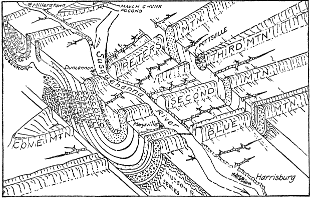
Fig. 25.—Diagram illustrating the topography and folded structure of the Appalachian Mountains west of Harrisburg, Pennsylvania. The valleys have been etched out of belts of weak rocks, while outcropping resistant rocks stand out to form ridges. Note the course of the Susquehanna River across the mountain ridges, this being a “superimposed river” (see text, p. 233). (Drawn by A. K. Lobeck.)
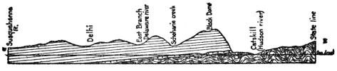
Fig. 26.—Only slightly tilted strata of Silurian and Devonian ages resting upon folded strata of Cambrian and Ordovician ages in an east-west section across the Catskill Mountains and Hudson Valley of New York. The folding took place at the time of the Taconic Mountain Revolution toward the end of the Ordovician period. (Drawn by the author.)
As already suggested, however, folding is not the only method by which mountains are formed. Many ranges are either entirely due to the tilting of earth blocks by faulting or fracturing of the earth, or their present altitude, at least, is a direct result of faulting. Such may be called block mountains. They are wonderfully represented by the various north-south ranges rising some thousands of feet above the general level of the Great Basin region of Utah and Nevada. These ranges are, in short, somewhat eroded edges of approximately parallel-tilted fault blocks lying between the Sierra Nevada Range and the Wasatch Range. In southeastern Oregon a series of nearly parallel block mountains, up to forty miles in length and over 1,000 feet in height, show very steep eastern fronts only slightly modified by erosion.
Another mode of origin of mountains is by the rise of molten material to the surface, especially where a chain of volcanoes is located. Thus the Cascade Mountains from northern California through Oregon and Washington, including Mounts Lassen, Shasta, Pitt, Baker, St. Helens, and Rainier, are very largely the result of volcanic action. The long chain of Aleutian Islands of Alaska, referred to in our study of volcanoes, is an excellent example of a great mountain range now being built up out of the sea by volcanic action. More locally molten rocks under pressure may not reach the surface but instead simply bulge or dome the strata over them, as in the case of the group known as the Henry Mountains of Utah, and also in other parts of the West.
In still other cases mountains of considerable area and altitude have resulted from erosion of uplifted regions where the uplift has been practically unaccompanied by either folding, faulting, or igneous activity. Any low-lying area, regardless of the character of its rocks, structure, or previous history, may be notably upraised and simply subjected to erosion. An excellent illustration is afforded by the Catskill Mountains of New York, where numerous deep valleys and narrow ridges have been carved out of upraised nearly horizontal strata. The so-called “Bad Lands” region of parts of South Dakota and Wyoming is also essentially of this type, where deep, narrow valleys and sharp ridges have been etched out of high, relatively soft, nearly horizontal strata, resulting in an almost impassable maze of mountains. In the high, recently upraised Colorado Plateau of parts of Arizona, New Mexico, Colorado, and Utah, nearly horizontal strata are being etched out, the result being numerous buttes, mesas (flat-topped hills and mountains) and deep canyons, including the Grand Canyon with its maze of peaks and pinnacles, many of them rising like mountains out of the canyon depths.
Mountains of the pure types just described are not the prevailing ones of the earth. Most mountains and their structures, as we see them to-day, are products of two or more of the processes of folding, faulting, igneous action, and erosion. A few well-known examples will suffice to make this matter clearer. Thus, the Appalachian Mountains originally developed by severe folding of thick strata. After considerable erosion, numerous small and large thrust faults developed, some of the dislocations amounting to miles. Then the whole range was cut down nearly to sea level by erosion, after which the district was upraised (without folding) mostly from 2,000 to 4,000 feet, and the present long, narrow mountain ridges and valleys have been carved out by stream erosion. Thus folding, faulting, and erosion all enter into the height and structure of the Appalachians.
A lofty mountain range still more complex in its history is the Sierra Nevada of California. First, thick strata were highly folded, upraised, and intruded by great masses of molten granite. Erosion then proceeded to cut the range down to hills, after which a great fracture (fault) developed along the eastern side and the Sierra Nevada earth block was notably tilted with steep eastern front and long western slope. Erosion has considerably modified the eastern fault face, and the deep canyons like Yosemite, King’s River and American River, have been carved out of the western slope of the great tilted fault block. Geologically recently the central to northern portion of the range has been affected by volcanic action, streams of lava in some cases having flowed down the valleys.
CHAPTER XI
A STUDY OF LAKES
L
LAKES are ephemeral features on the face of the earth. Compared to the tens of millions of years of known earth history, lakes, even large ones, are very short lived. They may, in truth, be regarded as merely results of the temporary obstructions to drainage. Lake basins are known to originate in many ways, and there are various means by which they are destroyed. Not attempting an exhaustive, scientific treatment of the subject, our present purpose may be well served by describing and explaining some of the better known and more remarkable lakes of the world.
Even a cursory examination of a large map of the world reveals the fact that the regions of most numerous lakes are those which were recently occupied by glaciers—either the vast ice sheets of the Glacial epoch or mountain (or valley) glaciers. This is because more lakes of the present time have come into existence as direct or indirect results of glaciation than by any other cause. A considerable number of these lakes occupy rock basins which have been eroded or excavated by the direct action of flowing ice. Small lakes of this sort are commonly found in the upper parts of valleys formerly occupied by mountain or so-called Alpine glaciers, because there the excavating power of such glaciers was especially effective. More rarely rock basins have been scoured out by glaciers farther down their valleys. Many lakes occupy rock basins excavated by ice in the high Sierra Nevada and Cascade Ranges, in the Rocky Mountains from Colorado into Canada, in the Alps, and in the mountains of Norway. Few, if any of them are, however, large or famous. Other lakes, some of very considerable size, occupy rock basins scoured out by the passage of the great ice sheets of the Glacial epoch in North America and Europe, though they are less common than formerly supposed. Some of the many lake basins of Ontario, Canada, are quite certainly of this origin, as might well be expected, because the power of the great ice sheet was there in general notably greater than south of the Great Lakes where the tendency was to unload or deposit the eroded materials as shown by the great accumulations of glacial débris (moraines).
Where the ice walls of certain existing glaciers form dams across valleys, waters are ponded, a small lake of this kind occurring alongside the Great Aletsch Glacier of the Alps, where its wall is slowly moving past a tributary valley. Lakes of this kind also occur in Greenland and in Alaska, but none are of considerable size. During the Great Ice Age, however, literally thousands of large and small lakes were formed, both during the advance and the retreat of the ice, wherever the glacier wall blocked valleys which sloped downward toward the ice. New York State furnishes many fine examples of large and small lakes of this sort. Thus, when the great glacier was melting in northern New York, waters hundreds of feet deep and many miles long were ponded between two ice lobes—one retreating eastward and the other westward from the Mohawk Valley. An ice dam lake was also formed a little later, when an ice wall blocked the northern part of the Black River Valley just west of the Adirondack Mountains and caused a lake covering about 200 square miles. One of the largest of all known ice dam lakes has been called Lake Agassiz, which attained a maximum length of over 700 miles and a width of 250 miles in the Red River of the North region of eastern North Dakota, western and northwestern Minnesota, and northward into Canada, most of its area having been in Canada. It began as a small lake with southward drainage into the Mississippi when the great northward retreating ice sheet formed a dam across the valley of the Red River of the North. The retreating ice continued to block the northward drainage until the vast lake, covering a greater territory than all of the present Great Lakes combined, was developed. Beaches, bars, deltas and the outflow channel of this remarkable lake are wonderfully well preserved. Lake Winnipeg is a mere remnant of great Lake Agassiz.
Many ponds and small lakes occupy basins formed by irregular accumulations of glacial (morainic) materials. Still others lie in depressions which formed by the melting of masses of ice which became wholly or partly buried by ice deposits, or by sediments washed into bodies of water which were held up by ice dams. Depressions of the latter kind are commonly found as pits or so-called “kettle holes” below the general level of sand flats or sand plains of glacial lake origin.
Most common of all lake basins of glacial origin are those formed by accumulation of glacial débris or morainic materials acting as natural dams across valleys. This is, in fact, the most common of all ways by which existing lake basins, some of them very large, have been formed. Most of the thousands of ponds and lakes of Minnesota, Wisconsin, and northern New York belong in this category.
In the Adirondack Mountains, for example, most of the lakes, like the well-known Lake Placid, Saranac Lakes, Long Lake, and Schroon Lake, have their waters ponded by single dams of glacial débris across valleys. In some cases a series of such dams blockades a valley and forms a chain of lakes like the well-known Fulton Chain in the Adirondacks. Less commonly the lake may have its waters ponded by two natural dams of glacial débris, one across a valley at each end of a lake. A very fine, large scale example of the last-named type is the famous Lake George in the southeastern Adirondacks. It is over 30 miles long and from 1 to 21/2 miles wide. It lies in the bottom of a deep, narrow mountain valley, mountain sides rising very steeply from a few hundred feet to 2,000 or more feet above its shores. There are many islands, especially in the so-called “Narrows,” thus greatly enhancing the scenic effect. The valley itself has been produced by a combination of faulting and erosion. There was a preglacial stream divide at the present location of the “Narrows.” This divide was somewhat reduced by ice erosion when the deep, narrow body of ice plowed its way through the valley during the Ice Age. During the retreat of the ice heavy morainic accumulations were left as dams across the valley at each end of the lake.
Another remarkable body of water, similar to Lake George in its origin, is Chautauqua Lake of western New York, famous for its Chautauqua assemblies. It lies 1,338 feet above sea level, with its northern end near the edge of the steep front of the plateau overlooking Lake Erie. Chautauqua Lake really consists of parts of two valleys, one sloping north and the other sloping south, each dammed by glacial deposits.
The famous Alpine lakes—Garda, Como, and Maggiore—have resulted from deposition of glacial morainic materials under conditions different from those above described. In these cases great mountain or valley glaciers once flowed down the valleys and spread out part way upon the Italian plain. Great accumulations of glacial débris took place around the borders of the glacier lobes, and, after retreat of the ice, the glacial deposits acted as dams ponding the waters far back into the mountain valleys.
The origin and history of the Great Lakes constitutes one of the most interesting and remarkable chapters in the recent geological history of North America. Most of the salient points have been well worked out and they may be very briefly summarized, as follows: Before the Ice Age the Great Lakes did not exist, because the region, prior to that time, had been land subjected to erosion for millions of years—a time altogether too long for any lake to survive. Their sites were occupied by broad, low, stream-cut valleys which were quite certainly locally somewhat deepened by ice erosion during the Ice Age. Ice erosion is, however, altogether insufficient to account for the great closed basins. The two most important factors entering into the formation of the basins of the Great Lakes were doubtless the great glacial (morainic) accumulations acting as dams along the south side, and the tilting of the land downward on the north side of the region. In support of this explanation it has been established that the great dumping ground of ice-transported materials from the north was in general along the southern side of the Great Lakes and southward. It has also been well established that, late in the Ice Age, the land on the southern side of the Great Lakes region was lower than at present, as proved by the tilted character of beaches of the well-known extinct glacial lakes which were the ancestors of the present lakes. Such a down-warp of the land must have helped to form the closed basins by tending to stop the southward and southwestward drainage of the region.
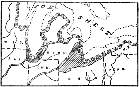
Fig. 27.—Sketch map showing a very early stage in the history of the Great Lakes when two relatively small lakes in front of the ice wall separately drained into the Mississippi River. (Drawn by the author from map by Taylor & Leverett.)
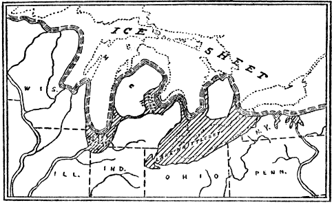
Fig. 28.—Lake Whittlesey stage of the Great Lakes history when the ice had retreated far enough to allow the eastern and western ice margin waters to join with a single outlet past Chicago. (Drawn by the author from a map by Taylor & Leverett.)
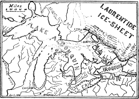
Fig. 29.—The Algonquin-Iroquois stage of the Great Lakes when their whole area was ice-free, and all their waters drained through the Mohawk-Hudson Valleys of New York into the Atlantic Ocean. (After Taylor, published by New York State Museum.)
We shall now very briefly trace out the principal stages in the history of the Great Lakes during the final retreat of the vast ice sheet. This may best be done by the aid of maps which need only brief explanation. When the ice sheet had retreated far enough northward to uncover the very southern end of the Lake Michigan basin and a little beyond, a small glacial lake (Lake Chicago) developed against the ice wall. Its outlet was through the Illinois River and thence into the Mississippi. At the same time a larger glacial lake, held up by the ice wall, developed over the western part of the Erie basin and beyond. Its outlet was through the Wabash River. With further retreat of the ice a large lake (Whittlesey) covering considerably more than the area of Lake Erie developed, with outlet westward across Michigan into the enlarged Lake Chicago which continued to drain into the Illinois River. During a still later stage of ice withdrawal the remarkable set of three glacial lakes existed—Lakes Duluth, Chicago, and Lundy. Each of these large lakes had its own outlet. Lake Duluth covered about half of the Lake Superior basin and drained through the St. Croix River into the Mississippi. Lake Chicago expanded to cover nearly all of the Michigan basin and continued to drain through the Illinois River. Lake Lundy covered not only more than the area of the Erie basin, but also considerable territory north of Detroit, and drained eastward alongside the ice lobe of the Ontario basin through the Mohawk and Hudson valleys of New York, and into the Atlantic Ocean. Just after the ice completely withdrew from the area now occupied by the Great Lakes, but still blocked the St. Lawrence Valley, the vast body of water called Lake Algonquin more than covered the sites of the present Superior, Michigan, and Huron. At this time the land was distinctly lower toward the northeast than at present, causing the outlets to the west to be abandoned. The great Lake Algonquin poured its waters eastward through the Trent River channel of Ontario, Canada, into glacial Lake Iroquois, which was the great ancestor of Lake Ontario. Lake Iroquois, in turn, had its outlet eastward through the Mohawk and Hudson Valleys of New York. For part of the time at least, Lake Erie maintained a separate existence discharging into Lake Iroquois near Buffalo. During the Algonquin-Iroquois stage the combined area of all the lakes was notably greater than the present area of the Great Lakes. The volume of water discharged by the lakes through the Mohawk Valley of New York was doubtless greater than that which now goes over Niagara Falls. Gradually, as the St. Lawrence ice lobe waned, the outlet waters of the lakes began to move alongside the ice through the St. Lawrence Valley. Finally the ice withdrew far enough to free the St. Lawrence Valley and the waters of the Great Lakes region dropped to a still lower level, bringing about the Nipissing Great Lakes stage not greatly different from the present. East and northeast of the Lakes the land was low enough to allow tidewater (the so-called Champlain Sea) to extend through the Hudson, Champlain, and St. Lawrence Valleys, and possibly into the Ontario basin, as proved by the occurrence of marine beaches and fossils. The waters in the Erie and Ontario basins covered about the present areas, while the Nipissing Lakes, which covered a little more than the present areas of the three upper Great Lakes, had their outlet through the Ottawa River channel into tidewater (Champlain Sea). Postglacial warping of the land has brought the whole region to the present condition.
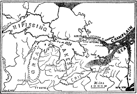
Fig. 30.—Map showing next to the present stage of the Great Lakes history when the land was lower on the north and the upper (Nipissing) lakes drained through the Ottawa River Valley into an arm of the sea (Champlain Sea) which reached through the Champlain and Hudson Valleys. (After Taylor, published by New York State Museum.)
Many lakes, including some remarkable ones, occupy basins which are directly due to movements of the earth’s crust—either faulting or warping. An example of a lake occupying part of a fault basin is the famous Dead Sea of Palestine. This lake lies in the lowest part of the Jordan Valley, which has geologically recently come into existence by the sinking of a long, narrow block of earth for several thousand feet between two great earth fractures (faults). The Dead Sea covers about 500 square miles and its surface lies about 1,300 feet below sea level, which makes it the lowest lake in the world. Almost equally remarkable is the fact that its depth is about 1,300 feet, so that the lowest part of the lake basin is 2,600 feet below sea level. The lake contains approximately 24 per cent salt, mostly common table salt, causing it to be a thick brine in which there is neither plant nor animal life—hence the name “Dead Sea.” At one time, probably just after the Ice Age, the lake was much larger and deeper, when it filled a considerable part of the Jordan Valley and had an outlet to the south. During the high-level stage the water was fresh, but gradually, as the climate became drier, evaporation was greater than intake, the outlet was abandoned, and the mineral matter (mostly chloride of magnesia and common table salt) carried by the streams in solution into the shrinking lake steadily accumulated until the high degree of salinity of the present time has been reached.
Great Salt Lake, Utah, is a remarkable lake whose history has been carefully studied. It occupies the lowest position of an extensive basin which, in turn, forms but part of the whole great district of Utah which has geologically recently sunk thousands of feet on the west side of the great fault already described as occurring along the western base of the Wasatch Mountains. At present the lake covers about 2,000 square miles, but its area fluctuates considerably. It is scarcely believable that this big lake has an average depth of only fifteen feet and a maximum depth of only fifty feet. It lies 4,200 feet above sea level, and it carries about 18 per cent salts in solution. Most abundant by far is common table salt, of which there are no less than 5,000,000,000 tons in solution. The waters also contain about 900,000,000 tons of other salts. Should the lake completely disappear by evaporation, these salts would be deposited. Allowing for cars 40 feet long and of 40 tons capacity, a train more than 1,000,000 miles long would be required to carry the salts. What has been the source of these salts? Great Salt Lake is not, as supposed by some, a remnant of an ocean once covering the region. Briefly, the explanation is as follows: At one time, when the climate was moister, the basin now only in part occupied by the lake was filled to overflowing with an outlet north into the Snake and Columbia rivers. That great body of water (called “Lake Bonneville”) covered nearly 20,000 square miles and its depth was about 1,000 feet deeper than now, the present depth being very small. Because it had an outlet that lake was, of course, fresh. Beaches and shore lines 1,000 feet above the present lake, and at various lower levels, are still wonderfully well preserved. When, due to climatic change, evaporation exceeded intake by streams, the outlet was cut off. But slowly, as the lake shrank, streams (especially the Jordan River) carried a little salt in solution, the percentage of salt increasing until the present stage has been reached. In a real sense, much of the salt was once in the sea, because it has been dissolved out of strata which accumulated under sea water long before the basin of Great Salt Lake came into existence.
Another famous lake, which also occupies part of a basin due to faulting, is Lake Tahoe in the Sierra Nevada Mountains, near Truckee, California. This lake, whose length is 21 miles, and width 12 miles, lies 6,225 feet above sea level. On almost all sides steep mountains rise several thousand feet above its waters. Its great depth of 1,635 feet makes it, so far as known, the second deepest lake in North America, Crater Lake, Oregon, only outranking it. The water is exceedingly clear. An experiment some years ago showed that a white disk eight inches in diameter could actually be seen through a thickness of 216 feet of its water. “The statement sometimes made that “Tahoe is an old volcanic crater” is not true. The region about the lake shows evidences of volcanic activity of various kinds, and the lake waters themselves have probably been dammed at times by outpourings of lava. A lava flow appears to have temporarily filled the outlet channel below Tahoe City. The lake, however, lies in a structural depression—a dropped (fault) block in the earth’s crust.” (U. S. Geological Survey.)
The basin of the largest lake in the world—the Caspian Sea—has resulted from warping of the earth’s crust. It has an area of 170,000 square miles, a maximum depth of 3,200 feet, and its surface is about 90 feet below sea level. The composition of its water and some of its animal life indicate that it was once an arm of the sea. It has been detached or cut off by an upwarp of the land between it and the Black Sea region. If this great lake is a cut-off arm of the sea, with no outlet, how do we explain the fact that its salinity is much less than that of the ocean? Toward the north, where it is shallow and fed by so much river water, it is, in fact, almost fresh water. Even the southern one-half carries not over 1 per cent of salt. The explanation is that a steady current passes through a narrow passageway into a gulf or bay on its eastern side where evaporation is much greater than over the general surface of the Caspian. The salt is, therefore, gradually accumulating at the estimated rate of 350,000 tons per day in this gulf, while the sea itself is becoming fresher.
The basin of Lake Champlain, about 100 miles long, was occupied by tidewater geologically very recently (that is, since the Ice Age), but it has been cut off by uplift of the land on the north, since which time the waters of the lake have been completely rinsed out and freshened.
Many lake basins directly result from volcanic action. In many parts of the world lakes, usually of small size, occupy craters of volcanoes as, for example, in the Eifel region of Germany, the Auvergne district of France, and near Rome and Naples in Italy. Such a lake of exceptional interest fills part of the great crater, several thousand feet deep, which resulted from the explosion of Mt. Katmai, Alaska, in 1912. The water of this lake, more than a mile wide and of unknown depth, is hot.
One of the most unique and beautiful lakes of the world is Crater Lake in the Cascade Mountains of southern Oregon. It partly fills a great, nearly circular hole, six miles in diameter, with a maximum depth of about 4,000 feet, in the top of a mountain (Plate 11). The lake is over five miles in diameter and nearly 2,000 feet deep, making it the deepest in North America. Its surface is about 6,200 feet above sea level. Precipitous rock walls rising 500 to 2,000 feet completely encircle the lake, the main body of whose water is of a marvelous deep, sapphire-blue color, while the shallow portions around some of the shore are of emerald-green. Crater Lake has very little intake except direct rainfall and snowfall, and its water is fresh. The great hole was not produced by an explosion like that of Katmai, but rather by the sinking of the top of a once much greater mountain. That the mountain was once about the size and shape of Mt. Shasta is proved by the fact that deep glaciated valleys lead up the slopes and end abruptly at the very rim of the present mountain. Obviously these valleys were scoured out in recent geologic time by glaciers whose sources were several thousand feet up on a former cone-shaped mountain. That the mountain top sank rather than exploded is proved by the absence of volcanic débris over the sides and base of the mountain.
Still another way by which lakes are formed by volcanic action is by streams of lava blocking valleys. The famous Sea of Galilee in Palestine was thus formed by a stream of lava, which geologically recently flowed down from the east into the Jordan Valley and across it, where it cooled to form a dam ponding the waters of the Jordan River. Because the river flows through the lake, its water is fresh. One of the most remarkable facts about this lake is that its surface lies nearly 700 feet below sea level. A number of lava-dam lakes are known in the Sierra Nevada and Cascade Mountains.
A very interesting case of a lake basin, formed by cutting off an arm of the sea without any movement of the earth’s crust, is the Salton Sink of southern California. This basin, many miles long and wide, lies below sea level, its lowest point being 287 feet below tide. The Gulf of California formerly reached much farther north and into California where it covered the site of the Salton Sink. Gradually the Colorado River, always loaded with sediment, built a broad delta deposit right across the gulf, the northern end of which thus became cut off, leaving a big salt lake. But the river flowed into the gulf, while in the dry climate the evaporation was great enough to gradually dry away the salt lake. This was the condition of things until 1904, when much of the river at a time of flood got out of control and, following the general course of a great irrigating canal, it flowed for several years into the lowest part of the Salton Sink, partly filling it to form a lake 45 miles long, 17 miles wide, and 83 feet deep. Since 1907 the lake has been notably decreasing in size, and it may entirely disappear.
Other ways by which lakes, mostly relatively small ones, may develop are by landslides blocking valley drainages; by streams cutting across winding curves leaving so-called “oxbow lakes” which are common, for example, along the lower Mississippi River; by wave and wind action along shores of lakes or sea; by filling so-called “sink holes” which result from dissolving or falling in of roofs of caves; and by beavers through whose industry dams are built across valleys or streams.
Some of the most common ways by which lakes may be destroyed are the following: by being filled with sediment carried in by streams, or by vegetation, or by both; by cutting down outlets; by evaporation due to a change in climate; by removal of the ice dam in certain types of glacial lakes; and by movements or warping of the earth’s crust.
CHAPTER XII
HOW THE EARTH MAY HAVE ORIGINATED
T
THE problem of the origin of the earth is essentially astronomical rather than geological, because geological history is considered to have begun when common earth processes, such as erosion, deposition, and transportation of sediments, etc., were brought into play. It is quite certain, however, that the earth in its pregeologic state gradually merged into its geological condition. For this reason the geologist is interested in the more important doctrines or hypotheses which have been put forth to account for the origin of the earth. In fact, one of the few hypotheses which must be taken seriously is largely the work of a geologist. The most acceptable hypothesis not only best satisfies the facts regarding the earth’s astronomical relationships, but also best harmonizes with our knowledge of the oldest known rocks and their history.
Since the problem of the origin of the earth is an essential part of the problem of the origin of the solar system, the following well-known facts should be clearly in the mind of the reader. Eight planets, including the earth, revolve in nearly circular paths around the central sun, whose diameter is 866,000 miles. The radius of the solar system is at least 2,800,000,000 miles, this being the distance of the outermost known planet (Neptune) from the Sun. Neptune requires 164 years for a trip around the sun, while the earth, which averages about 93,000,000 miles from the sun, makes its circuit once a year. The planets all revolve around the sun in the same direction, and in nearly the same plane. The sun and all eight planets rotate on their axes in the same direction, the earth’s rotation being accomplished every twenty-four hours. Most of the planets have one or more smaller bodies called satellites revolving about them, such as Earth, with its one satellite (the moon), and Saturn, with its eight satellites, etc. It is well known that this solar system is only a very small part of the vast universe, as shown by the facts that no star is nearer the earth than several trillion miles, and that some stars are so far away that light traveling at the rate of 186,000 miles per second requires a thousand years to reach the earth!
Toward the end of the eighteenth century the famous nebular or ring hypothesis was set forth by the astronomer named Laplace. This assumes an original very hot incandescent mass of gas spheroidal in shape and greater in diameter than the present solar system. This mass rotated in the direction of rotation of our sun and its planets. Loss of heat by radiation caused the mass to shrink, and this in turn not only made it rotate faster, but also caused the centrifugal force (i.e., the force whose direction was from the center) in its equatorial portion to gradually become stronger. Finally a time came when the force of gravity (i.e., the force whose direction was toward the center) and the centrifugal force became equal and a ring was left (not thrown) off, while the rest of the mass of gas continued to shrink. After a time the material of the ring collected to form the outermost planet. The other planets were similarly formed from other rings which were left off as contraction of the great mass of gas went on. The sun represents the remainder of the great mass of rotating gas.
What is the bearing of this nebular hypothesis upon the early geological history of the earth? According to the hypothesis the earth must once have been much more highly heated and larger than now. It condensed to a liquid and then it cooled enough to permit the formation of a solid crust over a liquid interior. It then had a hot dense atmosphere containing all the water of the earth in the form of vapor, and this atmosphere steadily became thinner due to absorption by the earth. When the pressure and temperature conditions became favorable, much of the water vapor condensed to form the ocean and the atmosphere gradually changed to its present condition. According to this view the oldest rocks of the earth must have been igneous because they resulted from the solidification of the outer part of the molten globe.
Within recent years certain serious objections to the nebular hypothesis have been raised, and Chamberlin and Moulton have formulated the planetesimal or spiral hypothesis as an attempt at a more rational explanation of the origin of the solar system. Some of the objections to the older doctrine are that among the many thousands of known nebulæ in the universe very few only are of the Laplacian or ring type, while spiral forms are abundant. Spectroscopic study shows that the nebulæ are not gaseous, but made up of either liquid or solid particles, and that the leaving off of rings would necessitate the assumption of an intermittent process which could scarcely have operated under the conditions of the hypothesis.
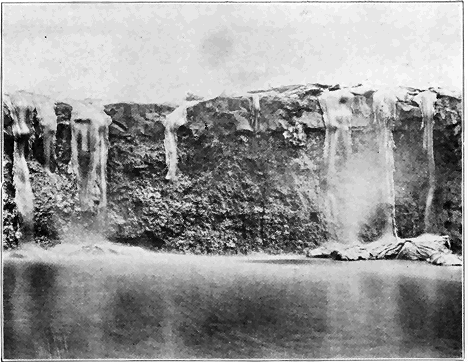
Plate 9.—(a) Molten Lava Flowing Over a Cliff Into Water in the Hawaiian Islands. (After Diller, U. S. Geological Survey.)
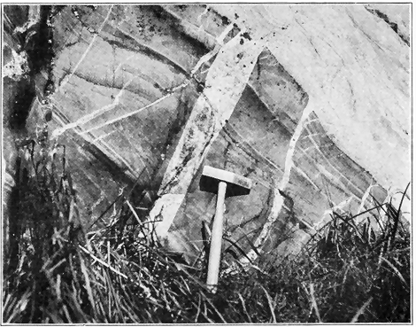
Plate 9.—(b) Dikes of Granite (Light Gray) Cutting an Old Dark Rock. While the granite on the right was being forced in molten condition upward into the earth’s crust, tongues of it (dikes) were sent off into the adjacent rock. (Photo by Howe, U. S. Geological Survey.)
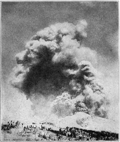
Plate 10.—(a) Lassen Peak, Northern California, in Eruption August 22, 1914. The great cloud of steam and volcanic ash rose several miles. This is the only active volcano in the United States proper, and it is now included in Lassen Volcano National Park. (By permission of R. E. Stinson, Red Bluff, Cal.)
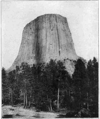
Plate 10.—(b) Devil’s Tower, Wyoming. This great mass of rock was forced in molten condition through strata which, because of their weakness, have been eroded away all around the hard igneous rock. This is probably the core or neck of a former volcano. (Photo by Darton, U. S. Geological Survey.)
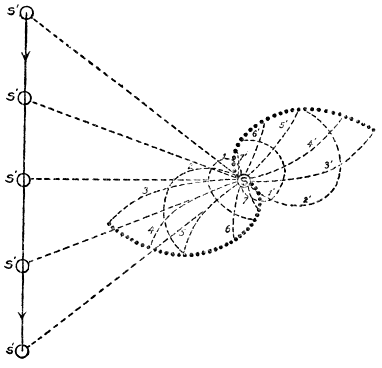
Fig. 31.—Diagram showing the origin and character of a spiral nebula according to the planetesimal hypothesis of the origin of the solar system. (Modified after Moulton.)
Anything like a full understanding of the planetesimal hypothesis would be difficult to obtain, and, in the brief space at our disposal, we shall attempt to make clear only a few of the salient points. According to this hypothesis the solar system was, during a previous stage of its evolution, a great, flat, spiral nebula, made up of finely divided solid or possibly liquid particles called planetesimals, among which were scattered some larger “knots” or masses. Each tiny particle and larger mass or knot is considered to have traveled in its own particular orbit or path about a central very large mass—the future sun. It is even suggested that the spiral nebula originated by disruption of one star by a swift-moving passing star. Each disrupted particle and large mass at first started straight for the large passing star, but because of change of position of the latter the particles and larger masses were gradually pulled around so that their paths curved into spirals. Because of crossing of paths, the larger masses or knots gradually increased in size by accretion of the small particles or planetesimals. Meteors (so-called “shooting stars”) which now strike the earth are thought to be disrupted materials still being gathered in, though very slowly at present. After the passing star got well out of range, the spiral paths of the disrupted masses gradually changed to nearly circular, due to a wrapping-up process around the central body (sun) which then controlled the movements of the both larger masses (future planets) and small masses (planetesimals).
Let us now inquire briefly into the bearing of this planetesimal hypothesis upon the early geological history of the earth. According to this doctrine the earth was never in the form of a highly heated gas, nor was it ever necessarily hotter than now. Instead of beginning as a much larger body which has gradually diminished in size, the earth steadily grew, up to a certain stage, by ingathering of planetesimals. Increase in size caused the force of gravity to increase and this caused not only steady contraction of the earth’s matter, but also a development of greater internal heat. The earth has been getting smaller ever since the force of compression has predominated over the building-up process, because of the diminishing supply of planetesimals. Due to steadily increasing internal pressure and heat the various gases, including water vapor, have been driven out of the earth to form an atmosphere which has gradually become larger and denser. After sufficient accumulation of water vapor, condensation and rainfall took place; the waters of the earth began to gather to form the oceans; and the ordinary geologic processes of erosion and deposition of strata were initiated. According to this view stratified rocks could have been formed very early in the history of the earth, and in this connection it is interesting to note that the oldest known rocks are actually of sedimentary origin.
CHAPTER XIII
VERY ANCIENT EARTH HISTORY
(Archeozoic and Proterozoic Eras)
W
WE shall now consider the older rocks of the Earth, including those of Archeozoic, Proterozoic, and Paleozoic ages. What are the salient points in the very early history of the earth (not including the evolution of organisms) shown by these very ancient rocks? Beginning with the oldest known rocks, it will be our purpose to trace out the principal recorded events of earth history in the regular order of their occurrence. As in human history, so in earth history the recorded events of very early times are fewest and most difficult of all to understand. In spite of this difficulty it is best to begin with the oldest known rocks or, as Le Conte has said, “to follow the natural order of events. This has the great advantage of bringing out the philosophy of the history—the law of evolution.” Because of limitation of space we shall give special attention to the physical history of North America, but the general principles brought out apply almost equally well to the other continents.
The Archeozoic rocks contain the earliest known records of geological history, or, in other words, the oldest recorded ordinary geological processes such as weathering and erosion, deposition of strata, igneous activity, etc. Although we are here dealing with the most obscure records of any great rock system, partly because the rocks have been so profoundly altered (metamorphosed), and partly because of the absence of anything like definitely determinable fossils, it is, nevertheless, true that certain very important conclusions have been reached regarding this very ancient geological era.
Among the very oldest of all known rocks of North America are the Grenville strata, so named from a town in the St. Lawrence Valley. In fact, no rocks elsewhere in the world have been proved to be more ancient. The Grenville series consists of a great mass of sediments (strata)—original muds, sands, and limes—which were deposited layer upon layer under water (Plate 12). The widespread extent and character of the series in southeastern Canada and the Adirondacks, and more than likely far beyond these limits, make it certain that the Grenville strata were accumulated on the bottom of a relatively shallow sea very much as sediments are now piling up on shallow sea bottoms. Thus, the most ancient definitely known condition of the region where the Grenville strata are exposed was an expanse of the sea covering the whole area. Wherever, in other parts of the world, the Archeozoic rocks have been studied, stratified rocks also seem to be the very oldest which are recognizable, but up to the present time no such rocks have been proved to be any older than, or even as old as, the Grenville series.
It may occur to the reader to ask, how long ago did the Grenville ocean exist? There are grave difficulties in the way of answering this question in terms of years since we have nothing like an exact standard for such a measurement or comparison. Although we must concede that not even approximate figures can be given, it can, nevertheless, be demonstrated by several independent lines of reasoning that the time must be measured by at least tens of millions of years, a very conservative estimate of the minimum time which must be allowed being about 50 million years. In any case, the time is so utterly inconceivable to us that the important thing to bear in mind is that the great well-known events of earth history, which have transpired since the existence of the Grenville ocean, require a lapse of many millions of years, as shown by revolutionary changes in geographic and geologic conditions such as the long periods of erosion, the enormous accumulations of sediment, the repeated spreading out and disappearance of sea water over many portions of the earth, and the building up and tearing down of great mountain ranges at various times. The ideas here expressed will be much better appreciated by the reader after following through the salient points in the history of North America as set forth in the succeeding pages.
Again, the reader may ask, by what line of reasoning do we conclude that these stratified rocks are so exceedingly ancient? All rocks of Archeozoic Age, including strata as well as certain younger igneous rocks (see below), invariably occupy a basal position in relation to all other rock systems. They constitute a complex lot of crystalline metamorphic rocks, combining certain characteristics which lie below the base of the determined sedimentary succession. Where rocks with the characteristics of the Archeozoic are separated from the oldest Paleozoic (Cambrian) strata by the great sedimentary or metamorphic system known as the Proterozoic (see below), we may be sure that we are dealing with Archeozoic rocks. If the series of rocks in question belongs in the Archeozoic system, all that remains is to determine its age position in that system. This can usually readily be done because wherever they have been studied the Archeozoic rocks may be subdivided into two groups of rocks, a sedimentary and an igneous. Where the igneous rocks, mainly granites and related types, occur associated with the sedimentary rocks (e.g., Grenville), they very clearly were forced or intruded, while molten, into the sedimentary rocks, thus proving these latter to be the older.
Since the Archeozoic strata of the Adirondack Mountains, southeastern Canada, and also all, or nearly all, other known districts are mostly badly disturbed, tilted, and more or less bent or folded, and since neither top nor bottom of the piles of strata has ever been recognized as such, it is impossible to give anything like an exact figure for the thickness of the series. Continuous successions of strata have, however, been observed in enough places to show that they were commonly deposited layer upon layer to a thickness of at least some tens of thousands of feet. A thickness of over 100,000 feet has been reported from southeastern Canada. The clear implication is that the Archeozoic sea which received sediments must have existed for a vast length of time which must be measured by at least some millions of years, because in the light of all our knowledge regarding the rate of accumulation of sediments a very long time was necessary for the piling up of such thick masses of strata. It does not, however, necessarily follow that the Grenville ocean was many thousands of feet deep where deposition took place. In fact, the very character of the original sediments (muds, sands, and limes) clearly indicates that the Archeozoic sea in which they accumulated was, for most part at least, of shallow water because such sediments have rarely, if ever, been carried out into an ocean of deep water. The great ocean abysses of to-day are not receiving any appreciable amount of land-derived sediment. Thus we are forced to conclude that in Archeozoic time, as well as many times in later ages, the shallow sea bottom gradually sank while the sediments accumulated. Even more conclusive proof of such subsidence has been obtained from the study of so-called “folded” mountain ranges of Paleozoic and later time, an excellent example being the Appalachian Range.
Having established the sedimentary origin and great antiquity of the Grenville series, we are led to the interesting and important conclusion that these oldest known rocks are not the most ancient which ever existed, because the Grenville strata must have been deposited layer upon layer, upon a floor of still older rocks. If such still older rocks are anywhere exposed to view, they have never been recognized as such. Again, the fact that the most ancient known rocks were deposited under water carries with it the corollary that there must have been lands at no great distances from the areas of deposition because, then as now, such sediments as muds and sands could have been derived only from the wear or erosion of lands, and have been deposited in layers under water adjacent to those lands. But we are utterly in the dark regarding any knowledge of the location or character of such very ancient lands.
The most ancient known strata, as we see them to-day, do not look like ordinary sediments such as shales, sandstones, and limestones. They have been profoundly changed from their original condition, that is to say, they have undergone metamorphism. The Archeozoic strata now exposed to view were formerly buried at least some miles below the earth’s surface, the overlying younger rocks having since been removed by erosion through the millions of years of time. Far below the earth’s surface, under conditions of relatively high temperature, pressure, and moisture, the materials of the strata were completely crystallized into various minerals. The surfaces of separation of the very ancient layers of sediment are still usually more or less clearly present (Plate 12). Original limestone has been changed into crystalline limestone or marble; sandstone has been changed into quartzite, and shale, sandy shale, and shaly sandstone have been changed into various schists and gneisses.
In western Ontario there are also stratified rocks (called the Keewatin series) which seem to be of about the same age as the Grenville strata farther east. A point of special interest in connection with the Keewatin strata is the presence of layers of lava in portions of the series, thus proving that molten rock materials were poured out on the earth’s surface during the most ancient known era of the earth’s history.
After the accumulation of the very ancient Archeozoic sediments igneous activity took place on grand scales when great masses of molten rock were forced (intruded) into the sediments from below. Masses of molten materials are known to have been thus intruded at several different times, but of these the most common by far cooled to form a great series of granite and closely related rocks. The general effect was to break the old strata up into patches or masses of varying sizes as clearly shown by the present distribution and modes of occurrence of these igneous rocks. In most cases the strata were pushed aside by, or tilted or domed over, the upwelling molten floods—in many cases the molten materials were, under great pressure, intimately forced or injected into the strata; numerous large and small masses of strata were caught up or enveloped (as inclusions) in the molten floods; in some cases there was local digestion or assimilation of the strata by the molten materials, while in still other places large bodies of strata seem to have been left practically intact and undisturbed. Such igneous rocks, which are very widespread, are all of the plutonic or deep-seated types; that is, they were never forced up to the earth’s surface like lavas, but they solidified at considerable depths (at least some thousands of feet) below the surface. We see them exposed to-day only because a tremendous amount of overlying rock materials has been removed by erosion. These igneous rocks are generally easily distinguished from the old sediments of Grenville age because of their more general homogeneity in large masses, and their lack of sharply defined bands or layers of varying composition. The fact that the minerals have always crystallized to form medium to coarse-grained rocks shows that these rocks solidified under deep-seated conditions, since it is well known that surface flows (lavas) are much finer grained commonly with more or less of the rock not crystallized at all. Slow cooling under great pressure favors more complete crystallization with growth of larger crystals.
As we have just learned, the very character and structure of the Archeozoic rocks now exposed to view show conclusively that they were formerly deeply buried, and the inference is perfectly plain that the overlying rock materials were removed by erosion. Profound erosion of any land mass means that the land must have stood well above sea level, and thus we come to the important conclusion that the great mass of Archeozoic rocks (both strata and igneous rocks) were upraised well above sea level. Just when the uplift occurred cannot be positively stated, but in every region where the matter has been studied it took place before the strata of the next geological era began to deposit as shown by the fact that such later strata rest upon the profoundly eroded surface of the Archeozoic rocks. Such an erosion surface, called an “unconformity,” marks a gap in the geological record of the district where it occurs. There is much to support the view that the uplift was concomitant with the great igneous intrusions, especially the granite. It is reasonable to believe that the same great force which caused the welling up of such tremendous bodies of liquid rock into the earth’s crust might easily have caused a decided uplift of a whole large region, but even so the process must have been geologically slow. In regard to the height of those ancient lands, the character of the topography, and the drainage lines we are as yet utterly in the dark. The fact that many thousands of feet in thickness of materials were removed by erosion to expose the once deeply buried rocks, does not necessarily imply that the lands at any time had great height, because it is possible that while elevation slowly progressed, much material was steadily removed by erosion. In the light of our knowledge of the origin and growth of mountain ranges of later time there is little doubt that at least some of the Archeozoic lands were raised to such mountain heights.
Thus far in our study of the Archeozoic rocks attention has been mainly directed to southeastern Canada and the Adirondack mountains, where careful studies have been made. In all parts of the world where the most ancient known (Archeozoic) rocks have been studied in detail the same general principles apply. Particular attention has been given to the Archeozoic rocks south of Lake Superior, and in the Piedmont Plateau of the eastern United States. In the accompanying map Archeozoic rocks are widely exposed to view within the areas shown in black. It has been estimated that Archeozoic rocks appear at the surface over about one-fifth of the land area of the earth. Where they are not at the surface it is believed that they everywhere exist under cover of later rocks. In other words, Archeozoic rocks are considered to be almost universally present either at or under the earth’s surface. This is true of the rocks of no other age. Special mention should be made of the fine exhibitions of Archeozoic rocks in Scandinavia and the Highlands of Scotland.
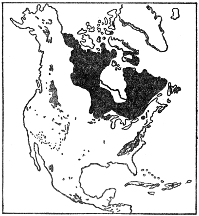
Fig. 32.—Map showing the surface distribution of Archeozoic and Proterozoic rocks in North America. (Redrawn by the author after U. S. Geological Survey.)
All known evidence leads us to the remarkable conclusion that the climate of much, or possibly all, of Archeozoic time was not fundamentally different from that of to-day. There must have been weathering of rocks, rainfall, and streams much as at present as proved by the character and composition of the stratified rocks which formed in that remote era. The presence of graphite (“black lead”) in crystalline flakes scattered through many of the strata shows that the climate must have been favorable to some form of life, because graphite thus occurring quite certainly represents the remains of organisms, this matter being more fully discussed in a succeeding chapter. In passing it may be stated that climatic zones were then probably scarcely if at all marked off, as they quite certainly were not even during Paleozoic time. One of the great contributions of geology to human knowledge is that during the tens of millions of years from Archeozoic times to the present the earth’s climate has undergone no fundamental change or evolution. In the earlier ages there was greater uniformity of climate over the earth, and, during known geologic time there have been rather localized relatively minor fluctuations giving rise to glaciers, deserts, etc., but there has been no real evolution of climate at all comparable to the marvelous evolution of organisms—both animals and plants.
We shall now turn our attention briefly to a consideration of the second great subdivision of geologic time—the Proterozoic era. Rocks of Proterozoic Age comprise all of those which were formed after the Archeozoic rocks and before the deposition of the earliest Paleozoic (Cambrian) strata, these latter being rather definitely recognizable because they contain fossils characteristic of the time. Cambrian strata are, in fact, the oldest rocks which contain anything like an abundance of fossils, so that the separation of rocks of either Archeozoic or Proterozoic Age from the earliest Paleozoic is seldom difficult. But how may we separate the Proterozoic rocks from the Archeozoic? Fossils afford us no aid whatever, because no determinable fossils have been found in rocks as old even as the earlier Proterozoic. The two great groups of very ancient rocks do, however, show a number of differences which must be considered together. Thus, igneous rocks distinctly predominate in the Archeozoic, while stratified rocks predominate in the Proterozoic. All Archeozoic strata are thoroughly metamorphosed (changed from their original condition), while large masses of the Proterozoic strata are only moderately metamorphosed, or even unaltered, and therefore look much like ordinary strata of later ages. Archeozoic rocks have almost invariably been notably deformed by more or less folding, tilting, etc., while the Proterozoic rocks show relatively much less deformation. Another important criterion is the fact that the Proterozoic rocks, wherever they have been studied in relation to the Archeozoic rocks, always rest upon a profoundly eroded surface of the latter, that is, an unconformity separates the two great sets of rocks. This erosion surface is of still further interest because it is the very oldest one known, none having been recognized within the Archeozoic group itself. Even where the Proterozoic strata have been considerably metamorphosed and deformed, this old erosion surface may be recognized, and if the rocks below that surface possess the characteristics of the Archeozoic rocks as described above, the two great very ancient rock groups may be distinguished. One of the triumphs of geology during the last 25 to 30 years has been the recognition of the great rock group (Proterozoic) between the Archeozoic and Paleozoic, thus bringing to light the records of an era which lasted many millions of years.
The length of time represented by the Proterozoic era is by many believed to have been fully as long as all succeeding eras—Paleozoic, Mesozoic, and Cenozoic—combined. Twenty million years would be a very conservative estimate for the duration of the era. What is the nature of the evidence as recorded in the rocks which lead us to conclude that the Proterozoic era lasted such a vast length of time? The great thickness of Proterozoic strata (over 30,000 feet in the Lake Superior region), in the light of what we have already learned regarding the present rate of wear (erosion) of lands and deposition of the eroded materials under ordinary conditions, clearly implies millions of years of time for their accumulation. But the Proterozoic strata as we now see them are in most places not a continuous pile, that is they were not accumulated layer upon layer without notable interruption. Thus, the thick Proterozoic group of the Lake Superior region has been divided into four distinct, mainly sedimentary series separated from each other by erosion surfaces (unconformities). Each erosion surface represents a long time when the area was elevated and underwent profound wear before the next series of strata accumulated on the worn surface. That such times of erosion were geologically long is proved not only by the profound alteration (metamorphism) of one set of strata before another accumulated, but also by the fact that granite, which, as we have learned, is never exposed except where much overlying material has been eroded, actually formed parts of surfaces of earlier Proterozoic rocks upon which later ones were deposited. In the Lake Superior region there are not only three great erosion surfaces (unconformities) within the Proterozoic group, but also one at the base separating it as a whole from the Archeozoic group, and another at the top separating it from the Paleozoic group. It is, therefore, fair to conclude that the amount of time (millions of years) represented by these great erosion intervals was fully as great as the time needed for deposition of the existing Proterozoic strata.
In the Lake Superior region the older Proterozoic strata are nearly all more or less folded and altered (metamorphosed), and they have been intruded by considerable bodies of molten rock, mostly granite. The later Proterozoic strata have been much less deformed and in many cases they are practically unaltered. In this region a very remarkable event took place in late Proterozoic time. This was volcanic activity on a grand scale. We may gain some idea of the stupendous and long-continued volcanic outpourings from the fact that, based upon actual measurements of thickness, lava sheets, averaging about 100 feet thick, poured out one upon another until a pile about six miles high had accumulated.
In parts of the Grand Canyon of the Colorado tilted Proterozoic strata may be seen resting upon the profoundly eroded surface of the Archeozoic rocks of the inner gorge. The Proterozoic strata, 12,000 feet thick, consist of practically unaltered sandstones, shales, and limestones, associated with some layers of basaltic lava. An erosion surface (unconformity) separates the whole group into two distinct series, and the group is separated from the overlying nearly horizontal Paleozoic (Cambrian) strata in the walls of the Canyon by another erosion surface.
More recently the Proterozoic strata so finely displayed in the Rocky Mountains of Montana and southern Canada have been studied. These strata, at least two or three miles thick, are mostly unaltered sandstones, shales, and limestones, associated with some metamorphic and igneous rocks. As usual, these strata rest upon the eroded Archeozoic. They were more or less upturned and folded before deposition of the succeeding Paleozoic strata. Satisfactory subdivisions have not yet been worked out.
In North America most of the areas shown on the accompanying map contain more or less Proterozoic rocks. Rocks of this age are known to some extent in all continents where their general relationships seem to be much like those of North America. They have perhaps been most carefully studied in Scandinavia and the Highlands of Scotland, where the strata portions are about two miles thick.
The climate of Proterozoic time must, for most part, have been about like that of to-day except, of course, for its much greater uniformity over the earth. About a dozen years ago very typical glacial deposits were discovered within the early Proterozoic rocks of western Ontario, Canada. A climatic condition favorable for the development of glaciers so early in the history of the earth is, to say the least, directly opposed to an idea (based upon the nebular hypothesis) long held that the climate of early geologic time must have been much warmer than that of the present.
CHAPTER XIV
ANCIENT EARTH HISTORY
(Paleozoic Era)
B
BEGINNING with the earliest Paleozoic, the legible records of events of earth history are far more abundant and less defaced than those of earlier times. Stratified rocks of the ordinary kinds greatly predominate over the igneous and metamorphic rocks, and the strata are in general far less disturbed than those of the Archeozoic and Proterozoic groups. From the earliest Paleozoic we have also the first abundant records (fossils) of the life of the earth, so that the ordinary methods of subdividing and determining the relative ages of the Paleozoic and later strata, as well as correlating the subdivisions (formations) in widely separated regions, can be used. From here on in our discussion of earth history we shall be able to trace the salient features of the changing outlines of the face of the earth, the coming and going of the seas over the lands, and the evolution of animals and plants with a considerable degree of definiteness and satisfaction.
First, we shall trace out, in the regular order of their occurrence, the main physical history events of Paleozoic time, leaving a consideration of the evolution of life for other chapters. Because of limitation of space, our attention will be almost wholly centered upon the continent of North America, but the reader should bear in mind that the general principles and facts set forth apply with about equal force to most other continents. In Europe the wonderful records of Paleozoic history are found in strata, whose estimated maximum thickness is about 100,000 feet! It must not be thought, however, that all these strata are piled up in a single locality, but the figure does actually represent the sum total of the greatest thickness of the many subdivisions (formations) of the Paleozoic rocks in different portions of the continent. In North America the maximum thickness of all Paleozoic rocks seems to be no less than 50,000 feet. More than 25,000 feet of strata may actually be observed piled layer upon layer in the highly folded and deeply eroded central Appalachian Mountains. The great thickness of the strata, combined with the facts that the fossils show that many marvelous, mostly progressive, changes took place among living things, that seas came and went repeatedly over many parts of the continent, and that great changes took place in the configuration of the land, force us to conclude that Paleozoic time must have lasted for many millions of years.
Just before the opening of the Paleozoic era practically all of North America appears to have been dry land, which had undergone so much erosion that it was low and far less rugged in relief than at present. This we know, because the rather widespread early Paleozoic (Cambrian) strata almost everywhere rest upon deeply eroded rocks of either Archeozoic or Proterozoic age. Considering both the time involved and the wide area affected, we have no record of anything like such a profound erosion interval since the beginning of the Paleozoic era. It seems that the constructive or upbuilding forces within the earth were then remarkably quiescent, while the destructive forces (erosion) were almost unhampered in their work of cutting down the land.
Have we any definite idea of the relations of land and water in North America during the first or Cambrian period of the Paleozoic era? In the affirmative answer to this question, certain principles will be brought out which the reader should keep in mind as we trace out the succeeding great physical changes in the history of North America. It should, however, be remembered that, in the brief space at our disposal, only the most general, or the most significant localized, physical changes in the long and intricate known history of the continent since the opening of the Paleozoic era can be brought out.
In early Cambrian time a narrow arm of the sea (like a strait) extended from the Gulf of St. Lawrence southward across eastern New York and over the site of the present Appalachian Mountains connecting with the Gulf of Mexico on the south. On the west, a much larger and broader arm of the sea (like a mediterranean) extended from Alaska southward over the site of the Rocky Mountains of Canada and across the sites of the Columbia Plateau to Great Basin of the western United States. All the rest of the continent was land, apparently almost or wholly devoid of high mountains.
By what process of reasoning do we conclude that arms of the early Cambrian sea reached across eastern and western North America? First, wherever marine strata of definitely determined early Cambrian age now occur, the early Cambrian sea must have existed because those strata were obviously deposited in that sea. Second, to those areas we must add others from which it can be demonstrated that early Cambrian marine strata have been removed by erosion. Enough field work along these lines has been done in North America to render it practically certain that the relations of land and water during early Cambrian time were essentially as above outlined.
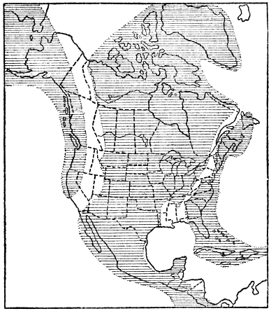
Fig. 33.—Map showing the relations of land and water in North America during early Cambrian time, at least 25,000,000 years ago. Lined areas represent land. (Principal data from a map by Willis published in the Journal of Geology.)
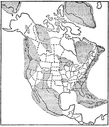
Fig. 34.—Map showing the relations of land and water in North America during Middle Ordovician time. Lined areas represent land. (Principal data from a map published by Willis in the Journal of Geology.)
As Cambrian time went on, the marine waters gradually spread from south to north across most of the Mississippi Valley area, causing the eastern and western arms of the sea to be connected, thus forming an interior continental sea. Otherwise the relations of land and water were much as in early Cambrian time. We know that the sea transgressed northward across the Mississippi Valley district because, on the south, the whole Cambrian system of strata (lower, middle, and upper) is present, while, farther north, only middle and upper Cambrian are present, and, farthest north, only upper Cambrian strata occur. This progressive northward overlap of younger and younger (later) Cambrian strata upon the old rock floor proves, that the Cambrian sea steadily spread farther and farther northward over the Mississippi Valley area. That this spreading sea was shallow is amply demonstrated by the deposits it left, such as shales, conglomerates (i.e., consolidated gravels) and sandstones, often ripple-marked. The Cambrian strata of North America vary in thickness from less than 1,000 feet to about 12,000 feet.
In the Mississippi Valley the Cambrian strata are unaltered and almost undisturbed from their original horizontal position. In the Appalachian Mountains of the east, and the Rocky Mountains of the west, the strata are commonly notably folded and faulted. In some places, as in western New England, the strata have been notably altered (metamorphosed).
The best estimates for the duration of the Cambrian period range from 2,000,000 to 3,000,000 years. It is a remarkable fact that, during this great lapse of time, North America was unaffected by any great physical disturbances such as mountain making, emergence of large tracts of land, or igneous activity. The one great physical event of the Cambrian was the gradual submergence of a considerable portion of the continent.
That the climate of the earliest Cambrian was at least locally favorable for the existence of glaciers, is proved by the occurrences of true glacial deposits in rocks of that age in China, Norway, and Australia. It is a remarkable fact that the glacial materials of China occur along the Yangtse River, thus demonstrating that conditions for glaciers then existed at a latitude as far south as New Orleans. These evidences of glaciation directly refute the old idea, based upon the nebular hypothesis, that the climate of the Paleozoic was distinctly warmer than now. The glacial evidence, added to our knowledge of the character and world-wide distribution of many identical species of animals, leads us to conclude that early Paleozoic climate was not essentially different from that of very recent geologic time, but that the climate was then much more uniform than at present.
During the second or Ordovician period of the Paleozoic era, the progressive submergence of Cambrian time continued until a climax was reached toward the middle of the period when fully four-fifths of the continent was submerged under shallow sea water. Since middle Ordovician marine strata are more widespread than the rocks of any succeeding age, we can be reasonably sure that so much of the continent was never again covered by the sea. In fact, so far as the records have been interpreted, this came nearest to being a universal flood in the whole known history of the continent. By the very character of the rocks deposited (seldom over a few thousand feet thick), we can be sure that the middle Ordovician continental sea was everywhere far shallower than the great ocean abysses of to-day. Because the lands were so low and restricted, relatively little land-derived sediment washed into the sea. But the shallow sea water was inhabited by millions of animals, the shells of many of which slowly accumulated to build up the thick bodies of limestone strata (Plate 14) which constitute the main bulk of rock of early and middle Ordovician age. The famous Trenton limestone, named from a locality in central New York, with its great abundance of fossils, was formed mostly by the accumulation of shells of animals during middle Ordovician time.
Later in the Ordovician there was a considerable shift in level between land and water causing a withdrawal of much of the widespread sea. As a result of the generally more elevated lands, erosion proceeded more vigorously, and sands and muds were more abundantly deposited in the restricted sea, these sediments having consolidated to form the shales and sandstones which predominate among the upper Ordovician rocks.
A principle above briefly explained in the discussion of the Cambrian may be reemphasized here. It is as follows: In making a map to show the relations of land and water, say during middle Ordovician time, the geologist is by no means dependent only upon actual surface exposures of middle Ordovician strata. Such exposures fall far short of giving an adequate conception of the former or even present real extent of such strata. In many places originally present Ordovician strata have been removed by erosion. An excellent case in point is the Adirondack region of northern New York. On the west side of the Adirondacks a great pile of marine Ordovician strata 1,500 feet thick end abruptly on the gently sloping flank of the mountains, thus clearly proving that the strata formerly extended at least twenty to thirty miles eastward. Again, in the southern Adirondacks a small area of very typical marine middle Ordovician strata lies fully fifteen miles from the general area of such rocks to the south. This small body of rock is very clearly only an erosion remnant of a general sheet of middle Ordovician rock which once covered the whole intervening district. In many other regions the middle Ordovician strata are definitely known to be concealed under cover of later rocks, as in the Mississippi Valley, where the actual surface exposures constitute only a fraction of the middle Ordovician strata which underlie nearly all the valley, as proved by deep well drillings, study of the scattering outcrops, etc. In still other places, middle Ordovician strata, associated with other rocks, are highly folded, as in the Appalachians, where such strata outcrop in only narrow belts following the trend of the folds. In short, then, wherever it can be proved that middle Ordovician marine strata are visible at the surface, or are concealed under other rocks, or were once present, we can be sure that the middle Ordovician sea existed. Exactly this principle applies to any subdivision of geologic time.
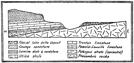
Fig. 35.—Structure section showing rocks representing three geologic eras separated by millions of years of time. Length of section 12 miles, vertical scale much exaggerated. At the bottom are Archeozoic (Precambric) rocks and resting upon them on the left are early Paleozoic strata 1,500 feet thick. A glacial lake deposit of late Cenozoic age lies on the Archeozoic rock toward the right. It is evident that the Paleozoic strata formerly extended much farther eastward. (By the author as published in a New York State Museum Bulletin.)
The Ordovician period closed with a great mountain-making disturbance in eastern North America, and at the same time all, or nearly all, of the continent was land. Throughout most of the Cambrian and Ordovician periods, the strata accumulated to a thickness of thousands of feet in the marine waters which spread over the eastern border of New York, the sites of the Green Mountains of Vermont, the Berkshire Hills of Massachusetts, and southward at least as far as Virginia, over the area of the Piedmont Plateau. At, or toward the close of the Ordovician period, a great compressive force in the earth’s crust was brought to bear upon the mass of strata and they were tilted, highly folded, and raised above sea level into a great mountain range known to geologists as the Taconic Range. It is quite the rule throughout this region of Taconic disturbance to find the strata either on edge or making high angles with the plane of the horizon. Many of the folds were actually overturned, and in some cases notable thrust faults developed, that is, the upper strata broke across and great masses were shoved over each other. These facts all go to show that the mountain-making compressive force applied to the region was of rather an extreme type. Since the origin of the Taconic Range a tremendous amount of erosion has taken place, so that literally only the roots of the range are now exposed in the Green Mountains, Berkshire Hills, Highlands-of-the-Hudson, and the northern Piedmont Plateau.
How do we know that the Taconic disturbance took place toward the close of the Ordovician period? By way of answer to this question two facts need to be considered. First, relatively late (or young) Ordovician strata are involved with the folds, thus proving that the folds formed after those late Ordovician sediments were deposited. Second, undisturbed strata formed during the middle of the next (Silurian) period, rest upon the eroded edges of the folds, which proves that the folds must have developed well before middle Silurian time because the only time they were subjected to erosion must have been during early Silurian time.

Fig. 36.—Structure section showing profile and underground relations of the rocks across part of the Highlands-of-the-Hudson region in southeastern New York. Length of section, sixteen miles. The rocks are mostly of Prepaleozoic Age, but with belts of highly infolded early Paleozoic strata toward the middle right. (After Berkey, New York Museum Report.)
Mention should also be made of the profound metamorphism (alteration) of the Cambrian and Ordovician strata along the main axis of the range, where the intense compression, aided by heat and moisture, caused the deeply buried portions of the strata to become plastic, and hence they became more or less foliated (cleavable) and crystallized into various metamorphic rock types, the limestone having changed to marble, the shale to slate or schist, and the sandstone to quartzite. Thus we explain the rocks of the extensive marble quarries of Vermont and western Massachusetts, the slate quarries of central eastern New York, and the Berkshire schist of the Berkshire Hills of Massachusetts.
One of the grandest and most significant of all the profound geological processes is the birth and history of a great folded mountain range. Since the Taconic Range affords us such an excellent example of a large-scale, well-understood folded range of great antiquity we may do well to consider it in the light of certain other broad relationships. The great compressive force which folded and upraised the Taconic Mountains did not accomplish its work rapidly in the ordinary human history sense of the word. The force was slowly and irresistibly applied, and the strata well below the surface were gradually bulged or folded, or fractured where near the surface, the length of time required for the operation having been, at the very least calculation, some hundreds of thousands of years, and more than likely a million years or more. Such a length of time is, however, so short compared with all known earth history, that we are accustomed to refer to the formation of such a mountain range as simply an event of geological history.
Even before such a range attains its maximum height a very considerable amount of erosion has already taken place. When the first fold appears above sea level, erosion begins its work and continues with increasing vigor as the mountain masses get higher and higher. Thus we have warfare between two great natural processes—the building up and the tearing down. After a time the building-up process wanes and then ceases, while the tearing-down process (erosion) continues either until the whole range has been completely worn down or until some rejuvenating force causes a renewed uplift. Here is an example of one of the remarkable procedures of nature. After millions of years of work causing the deposition of thousands of feet of strata, piled layer upon layer on the sea floor, a force of lateral pressure is brought to bear and a mountain range is literally born out of the sea. No sooner is the range well formed than the destructive processes (erosion) unceasingly set to work to destroy this marvelous work. But the sediments derived from the wear of the range are carried into the nearest ocean again to accumulate and, perchance, after long ages, to be raised into another range; and so the process may be often repeated. From this we learn that the mountain ranges of the earth are by no means all of the same age. The original Adirondacks were formed long before the Taconics, which originated millions of years before the Appalachians, these latter having been folded up long before the Sierras. The Rockies, followed by the Coast Ranges, are each younger than the Sierras as regards their original folding and uplift. Among foreign countries special mention should be made of the British Isles, where Ordovician strata thousands of feet thick were, late in the period, notably folded and upraised, the crustal disturbance having been accompanied by great intrusions of molten rocks and vast outpourings of lavas, so that this region ranks among the greatest of the ancient volcanic areas of Europe.
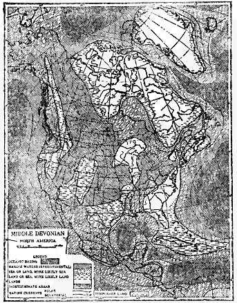
Fig. 37.—Map showing the general relations of land and water in North America during middle and late middle Devonian time fully 15,000,000 years ago. (After Willis, courtesy of the Journal of Geology.)
We shall now turn our attention to a very brief consideration of the salient points in the physical history of North America during the next great period (Silurian) of the Paleozoic era. As a result of the physical disturbance late in the Ordovician the great interior sea was largely or wholly expelled from the continent, and this was essentially the condition of the continent at the beginning of the Silurian. But this condition was of short duration, for early in the Silurian the sea again began to spread, gradually increasing in extent to a climax in about the middle of the period. At this time the famous and extensive Niagara limestone, so named from the rock at the crest of Niagara Falls, was deposited. Except for the newly formed Taconic Range, standing out as a bold topographic feature along the middle Atlantic Coast, and a somewhat wider extent of land, the condition of the continent during middle Silurian time was very similar to that of middle Ordovician time.