Front matter (continued 2)
Reading edition
A type of glacial erosion which is of special interest is the sculpturing of so-called “cirques” or “amphitheaters” in mountains within the region of perpetual snow. Where the main mass of snow and ice in the catchment basin or gathering ground of a valley glacier pulls away from the snow and névé on the upper slopes, the rock wall is more or less exposed in the deep crevasse. During warm days water fills the joint cracks in the rocks down in this crevasse (so-called “Bergschrund”), and during cold nights the water freezes and forces the blocks of rock apart. This is greatest toward the bottom of the crevasse and so, by this excavating or quarrying process, vertical or very steep walls are developed around a great bowlike basin or cirque. Such cirques, now free from glacial ice, with precipitous walls 500 to 2,000 feet high and one-fourth of a mile to one-half of a mile across, are common in the Sierra Nevada and Cascade Ranges and in the Rocky Mountains.
What becomes of the materials eroded by the ice? An answer to this question involves at least a brief discussion of the deposition of glacial débris, this constituting an important feature of the work of ice. The débris transported by a glacier is carried either on its surface or within it, or pushed along under it. It is generally heterogeneous material ranging from the finest clay through sand and gravel, to bowlders of many tons' weight. Various types of glacial deposits are abundantly illustrated by débris left strewn over much of the northeastern United States and some reference to these will be made.
Most valley glaciers carry considerable débris on their surfaces, this representing material which falls or is carried down from the valley walls upon the margins of the ice, thus forming marginal moraines. When two glaciers flow together, one marginal moraine from each will coalesce to form a medial moraine. The material carried along at the bottom of a glacier is called the ground moraine. Where it contains much very fine grained material with pebbles or bowlders scattered through its mass, it is called “till” or “bowlder clay.” The pebbles or bowlders of the ground moraine are commonly facetted and striated as a result of having been rubbed against the bedrock on which the glacier moved. Ground moraine material is the most extensively developed of all glacial deposits. It is so widely scattered over the glaciated northeastern portion of the United States that most of the soils consist of it, having been left strewn over the country during the melting of the vast ice sheet.
When a glacier remains practically stationary for some time, more or less material which it carries is piled up at its lower end to form a terminal moraine. Repeated pauses during general glacier retreat permit the accumulations of so-called recessional moraines. A wonderful display of recessional moraines occurs from the Great Lakes south, where they are festooned one within another and remain almost exactly as they were formed during pauses in retreat of great lobes of ice during the closing stages of the Ice Age. A great terminal moraine marks the southernmost limit of the ice sheet during the Ice Age, a very fine illustration being the ridge of low irregular hills extending the whole length of Long Island. Some of the material in that morainic ridge was transported by the ice from northern New England.
Considerable rock débris is transported within the ice, and such “englacial” material in part results from rock débris which falls on the surface in the catchment basin and becomes buried under new snowfalls which change to ice, and in part from material which falls into the crevasses in the glacier farther down the valley. Marked objects thrown into the catchment basin have, after many years, emerged at or near the end of the glacier; thus the rate of motion can be very accurately told. A very remarkable case of transportation through the body of a glacier is the following: In 1820, three men were buried under an avalanche in the catchment basin of the Bossons Glacier in the Alps. Forty-one years later several parts of the bodies, including the three heads together with some pieces of clothing, emerged at the foot of the glacier after traveling most of its length at the rate of eight inches per day. The heads were so perfectly preserved after their remarkable journey in cold storage that they were clearly recognized by former friends!
Where a valley floor slopes downward away from the end of a glacier, waters emerging from the ice, heavily loaded with rock débris, cause more or less deposition of the débris on the valley floor often for miles beyond the ice front. Such a deposit is called a “valley train.” When the ice front pauses for a considerable time upon a rather flat surface, the débris-laden waters emerging from the ice develop an “outwash plain” by deposition of sediment rather uniformly over the flat surface. A very fine example is the plain which constitutes most of the southern half of Long Island just beyond the southern limit of the great terminal moraine ridge.
A type of glacial deposit of particular interest is the “drumlin” which is, in reality, only a special form of ground moraine material (commonly till), and, therefore, essentially unstratified. Typical drumlins are low, rounded mounds of till with roughly elliptical bases and steeper fronts facing the direction from which the ice flowed. Their long axes are always parallel to the direction of ice movement. In height they commonly range from 50 to 200 feet. Their mode of origin is not yet definitely known, but they form near the margins of broad lobes of ice either by erosion of earlier glacial deposits, or by accumulation beneath the ice under peculiarly favorable conditions, as perhaps in the longitudinal crevasses. One of the finest and most extensive exhibitions of drumlins in the world is in western New York between Syracuse and Rochester. Thousands of drumlins there rise above the general level of the Ontario plain, the New York Central Railroad passing through the very midst of them. Drumlins are also abundant in eastern Wisconsin.
Another type of glacial deposit in the form of low hills is the “kame” which, unlike the drumlin, always consists of more or less stratified material. Kames are seldom over 200 feet high, and they are of various shapes. In many cases they form irregular groups of hills, and in other cases fairly well defined kame ridges. Kames form as deposits from débris-laden streams emerging from the margins of glaciers, the water sometimes rising as great fountains because of the pressure. Such deposits are now actually in process of formation along the edge of the great Malaspina Glacier of Alaska. Kames are commonly associated with terminal and recessional moraines. “Eskers” are similar except that they are long winding low ridges of stratified material deposited by débris-laden streams, probably in longitudinal fissures in the ice near its margin. (See Plate 20.)
Glacial bowlders, or “erratics” are blocks of rock or bowlders left strewn over the country during the melting of the ice. They vary in size from small pebbles to those of many tons of weight, and most of them were derived from ledges of relatively hard, resistant rocks. (See Plate 20.) Erratics have very commonly been carried a few miles from their parent ledges, while more rarely they have traveled even hundreds of miles. They are extremely abundant in New York and New England, many occurring even high up on the mountains. In some cases erratics of ten or more tons' weight have been left in such remarkably balanced positions on bedrock that a child can cause one of them to swing back and forth slightly. Such a bowlder is literally a “rocking stone.” In the Adirondack Mountains the writer recently observed a rounded erratic of very hard rock fourteen feet in diameter resting in a very remarkably balanced position on top of another large round glacial bowlder.
CHAPTER VI
THE ACTION OF WIND
O
ONLY during the last quarter of a century have geologists come to properly appreciate the really important geological work of the wind. One reason for this is the fact that people live mostly in humid regions where the soils are largely effectually protected against wind action by the vegetation. But even in such regions, wind action is by no means negligible. One has but to observe the great clouds of dust raised by strong wind from freshly cultivated fields during a little dry weather in the late spring. Much of this dust is carried considerable distances, often miles, and in some cases young crops are injured by removal of soil from around the roots, while in other cases young plants are buried by deposition of the wind-blown material over them. In humid regions, the action of the wind is perhaps most strikingly exhibited along and near shores of sea and lakes, where loose dry sands are picked up and transported in great quantities, often depositing them as sand dunes, which may form groups of hills covering considerable areas. Very conspicuous examples are the sand dunes of Dune Park in northern Indiana, and the dunes along the coast of New Jersey.
But the action of wind is most strikingly effective in desert and semiarid regions. The importance of the work of wind is made more impressive when we realize that about one-fifth of the land of the earth is desert.
In deserts some of the ordinary agents of weathering and erosion are either absent or notably reduced in effectiveness. Thus, stream action is, in general, reduced to a minimum; weathering effects due to moisture in the air are notably reduced, and either frost action, or wedge work of ice, is relatively unimportant due to lack of water. Change of temperature between night and day is, however, unusually important as a process whereby rocks are broken up due to relatively rapid expansion and contraction in deserts because such temperature changes are exceptionally great, and rocks and soils are almost everywhere directly exposed, being free from vegetation.
The finer grained materials, especially sand grains, in deserts are picked up by the wind and driven, often with great velocity, against barren rock ledges and large and small rock fragments. By this process (corrasion) the rocks are worn and often polished by the materials blown against them. The principle is that of the artificial sand-blast, used in etching glass, or cleaning and polishing building and decorative stones. Under favorable conditions wind-driven sand accomplishes noticeable erosion in a surprisingly short time. Thus, in a hard wind storm, a plate glass window in a lighthouse on Cape Cod was worn to opaqueness, while in a few weeks or months the directly exposed window glass may there be worn through.
The great erosive effect of wind-driven sand is relatively close to the ground because the larger and heavier fragments are not lifted to very considerable heights. For this reason ordinary telegraph poles are difficult to maintain in desert regions because, unless they are specially protected, they are soon cut down by sand swept against their bases. In the desert regions of our Southwestern States cliffs rising above the general level of the country are often undercut by wind erosion, sometimes with the development of large caverns. (See Plate 1.) Even the high portions of great ledges are there more or less fantastically sculptured by wind erosion, the softer portions being more deeply cut into than the harder. The famous sphinx of Egypt has been notably roughened by action of this kind.
The enormous power of high winds to transport rock material in desert regions is strikingly illustrated by the great sand storms of the Sahara Desert, where sand and dust, forming clouds with cubic miles of volume, sweep for many miles across the country. Some one has estimated that every cubic mile of air in such a storm contains more than 100,000 tons of rock material. It is said that an army of 50,000 men under Cambyses was buried under the sands of a storm in the desert of northern Africa.
Dust from some of these storms is known to be driven hundreds of miles out over the Atlantic Ocean, there to settle in the sea. In mountainous desert regions, like the Great Basin of our Western States, the general tendency is for the rock materials wind-eroded from the mountains to be carried into the intermontane basins or valleys. Some basins of this sort are believed to contain depths of 1,000 to 2,000 feet of wind-blown material.
A special kind of wind-blown material called “loess,” is a sort of fine-grained yellow, or brown loam which, though relatively unconsolidated, has a remarkable property of standing out as high steep cliffs or bluffs along the banks of streams. Many thousands of square miles of northern China are covered with loess. Among many other regions, thousands of square miles of parts of the States of Iowa, Nebraska, and Kansas are covered with loess, which, in this case, is believed to be fine material gathered by winds from the region just after the retreat of one of the ice sheets of the great Ice Age, when there was very little vegetation to hold down the loose soils of glacial origin.
Much as snowdrifts are formed, so, in many places, the wind-driven sands are built up into sand hills or so-called “dunes.” Dunes are very common in many places, as for example, along our middle Atlantic coast; in Dune Park of northern Indiana; and in the great arid and semiarid regions of the Western States. Where there is a distinctly prevailing direction of wind, the sand is blown to the leeward side from the windward side, and the dunes are caused to migrate in the direction of the wind. The burial and destruction of forests, and the uncovering of the dead trees is not uncommonly caused by migration of sand dunes, all stages of this phenomenon being well exhibited in Dune Park, Indiana. The rate of dune migration is very variable, but study in a number of places has shown a rate of from a few feet to more than 100 feet per year. Arable lands, buildings, and even towns have been encroached upon and buried under drifting sand. An interesting example is a church in the village of Kunzen, on the Baltic seashore which, in a period of sixty years, became completely buried under a dune and then completely uncovered by migration of the dune. Much destruction has been wrought by shifting sands on the Bay of Biscay, where farms and even villages have been overwhelmed. The ruins of the ancient cities of Babylon and Nineveh are buried mostly under wind-blown sand and dust. There is good reason to believe that the climate of central and western Asia is now notably drier than it was a few thousand years ago, and this may help to explain the burial of many old cities and villages there under wind-blown deposits.
CHAPTER VII
INSTABILITY OF THE EARTH’S CRUST
T
THE crust of the earth is unstable. To the modern student of geology the old notion of a “terra firma” is outworn. The idea of an unshakable, immovable earth could never have emanated from the inhabitants of an earthquake country. In general we may recognize two types of crustal movements—slow and sudden. To most people the sudden movements accompanied by earthquakes are more significant and impressive because they are more localized and evident, and often accompanied by destruction of property, or quick, though minor, changes in the landscape. But movements which take place slowly and quietly are often of far greater significance in the interpretation of the profound physical changes which have affected the earth during its millions of years of known history.
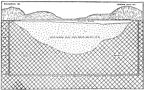
Fig. 7.—Structure section across the Hudson River Valley near West Point, New York. The shafts and tunnel, 1,200 feet below sea level, in solid rock, show the position of the New York City aqueduct from the Catskills. The Preglacial valley has been submerged and filled with Postglacial sediment to a depth of nearly 800 feet. (Redrawn by the author after Berkey, from New York State Museum Bulletin.)
A few well-known examples will serve to prove that upward, downward, and differential movements of the earth’s crust have actually taken place not only in the remote ages of geologic time, but also that such movements have geologically recently taken place, and that similar movements are still going on. It is very important that the reader thoroughly appreciate the fact that crustal disturbances, often profound ones, do take place, because this is one of the most fundamental tenets of geologic science. Let us consider the case of the Hudson-Champlain-St. Lawrence Valley region. That the whole region was once notably higher (at least 1,000 feet) than at present is proved by the drowned character of the Hudson Valley, in which tidewater extends northward for 150 miles to near Troy. Where the New York City Aqueduct passes under the Hudson River near Newburgh, the bedrock bottom of the old river channel is now about 800 feet below sea level as determined by drilling. This old channel is there filled up nearly to sea level with glacial and postglacial rock débris, which shows that the old channel must have been cut before the oncoming of the ice of the great Ice Age. Before the Ice Age, then, the lower Hudson Valley must have been considerably more than 800 feet higher than at present, because it then contained a river with sufficient current to be an active agent of erosion, carving out the canyonlike valley in the vicinity of West Point. This conclusion is strongly reenforced by the fact that the old valley of the Hudson River has been definitely traced as a distinct trench across the shallow sea bottom for about 100 miles eastward from the entrance to New York harbor. Toward the eastern end of this trench the depth of water is now considerably over 1,000 feet, and thus it is obvious that, preceding the Ice Age, the earth’s crust in the vicinity of New York City must have been much higher than at present, so that the Hudson River was able to erode its now completely drowned channel. Somewhat similar evidence has also established the fact that the lower St. Lawrence Valley region was much higher before the Ice Age. It is evident, therefore, that the general Hudson-St. Lawrence Valley region is now notably lower with reference to sea level than it was before the Ice Age. That this was caused by actual sinking of the earth’s crust rather than by a rise of sea level is proved by the fact that similar changes of level between land and sea did not take place at the same time even along the Atlantic and Gulf coast of our Southern States.
We shall now proceed to the next step in the geologically recent history of earth-crust movements in the Hudson-Champlain-St. Lawrence Valley region by asserting that, since the Ice Age, the land was actually notably lower than at present. In fact, the land was enough lower to allow tidewater to extend up the St. Lawrence Valley into the Ontario basin, and all through the Champlain-Hudson Valley. Many beaches, bars, and delta deposits formed in these arms of the sea are still plainly preserved, in some cases with shells and bones of marine animals in them, now hundreds of feet above sea level. These marine deposits are highest above sea level in the northern portion of the Champlain Valley, where they lie at an altitude of 700 feet or more and their altitude steadily diminishes southward to about 300 to 400 feet in the general vicinity of Albany, and to near sea level in the general vicinity of New York City. Obviously, then, the land stood lower during part or all of the interval of not more than a few tens of thousands of years since the Ice Age than at present. This leads us to the third important conclusion regarding earth movements in this region, namely, that still later the land has undergone a differential uplift, the rate having steadily increased toward the north where the total uplift is many hundreds of feet. We have discussed this region somewhat in detail because the principles of slow up and down movements of the earth’s crust are there so plainly recorded.
Among many other regions where earth movements similar to those above described have taken place, brief mention may be made of Norway. The great fjords of Norway were, just before the Ice Age, stream-cut valleys which were then more or less modified by glacial erosion, and after the Ice Age the rivers in them were drowned due to land subsidence. The kind of evidence is like that above given for the lower Hudson River. Since the subsidence there has been partial reelevation, as proved by the fact that along the sides of the larger fjords marine terraces and beaches may be traced with gradually increasing altitude for many miles (150 or more) back into the country where they are hundreds of feet above tidewater.
Scandinavia is of still further special interest because very appreciable earth movements have there come under human observation. Marks carefully placed along the shores of Sweden by the government have proved that during the last 150 years the southern end of the country has actually subsided several feet, while from Stockholm north the land has risen in increasing amount, reaching a maximum of seven or eight feet. In southern Sweden, at Malmo, a certain street now at times becomes covered by wind-driven high water, and during excavations made some years ago an older street eight feet below the present one was found.
A theory which appears to be in perfect harmony with the facts to account for the subsidence and partial reelevation of central eastern North America and Scandinavia since the beginning of the Ice Age is that the great weight of ice during the Ice Age pressed the land down, and that since the removal of the ice there has been an appreciable tendency for the land to spring back.
Certain crustal movements which have occurred about the Bay of Naples are of very special interest because actual human history dates can be placed upon them. Most remarkable are the records in connection with the temple of Jupiter Serapis which was built near the shore before the Christian era. The land sank about five feet and a new pavement had to be constructed; then, by the middle of the third century A. D., the temple rose to well above sea level. By about the ninth century the land had subsided fully thirty feet, so that marble columns of the temple were bored full of holes as high as twenty-one feet above their bases by marine-shelled animals, species of which still live in the bay. Then a slow uplift of twenty-three feet began, bringing the bases of the columns two feet above sea level by 1749. Since that time a slight sinking has taken place and this seems to be still going on. Three of the marble columns with the borings still stand in upright position.
While the movements just described were taking place, the island of Capri, twenty miles across the Bay of Naples, has slowly sunk to an amount estimated at thirty or forty feet as proved by evidence from the famous Blue Grotto. About the beginning of the Christian era a large ancient wave-cut cave, part of which is now called the Blue Grotto, had its floor above sea level, and it was used by certain Romans as a cool place to retire to from the heat. In order to obtain better light an opening was cut through its upper portion. The land has sunk so much that at the present time even part of the artificial opening (through which tourists pass) is now under water.
By way of illustrating remarkable contrasts in direction of crustal movements on very considerable scales in a given region, we shall briefly mention some facts regarding part of the coast of southern California and the neighboring islands of Santa Catalina and San Clemente, respectively twenty-five and fifty miles offshore. Those movements were not, however, checked up by human history records. The mainland at San Pedro has clearly risen 1,240 feet, as proved by the presence of unusually perfect coast terraces (so-called “raised beaches”), while San Clemente has risen 1,500 feet as proved by the raised beaches into which deep, youthful V-shaped stream-cut valleys have been sunk, and a shore line characteristic of recent notable uplift. It is a remarkable fact that at the same time the intervening island (Santa Catalina) has notably sunk, as proved by the nature of its shore line, and the distinctly more mature character of its topography.
We are, however, by no means dependent upon lands along sea shores for evidences of slow rising and sinking of land. Thus, by careful measurements it has been shown that the general region of the Great Lakes is now differentially rising toward the northeast at the rate of about five inches per 100 miles per century. At Chicago the rise of water is estimated at about nine inches per century, which means increase of flowage through the Chicago Canal. At this rate the upper lakes would, in some thousands of years, drain through this canal to the Mississippi. A well-preserved shore line of the large ancestor of Lake Ontario shows a steady increase in altitude at the rate of several feet per mile toward the northeast from near Niagara to the St. Lawrence Valley, thus proving a tilting of the land since the shore line was formed.
Shore lines of the great ancestor of Great Salt Lake also show warping of the earth’s crust, some parts of a definite shore line being several hundred feet higher than others.
Very significant evidence pointing to profound crustal movements consist in the finding of fossil remains of marine animals in the strata high above sea level, very commonly from one to three miles, in many parts of the world, especially in the high mountains. In Wyoming, nearly horizontal strata of the Mesozoic Age carrying marine fossils lie two miles or more above sea level. The fact that given formations, carrying marine fossils representing certain definite portions of geologic time, are found at various altitudes up to several miles in many parts of the world, shows that the land in those places has really risen relative to sea level.
It should not be presumed from the above discussion that the sea level itself has never changed. Thus, the vast areas of thick ice sheets in both North America and Europe during the Great Ice Age represented sufficient water withdrawn from the sea to very appreciably lower its level. All land-derived materials, carried into the sea mainly by rivers, displace sea water, with consequent rise of its level. If all existing lands were worn down and carried into the sea, its level would be raised some hundreds of feet. Subsidence of any part of the ocean bottom would cause a lowering of sea level. There is a strong reason to believe that some such shiftings of sea level have occurred during the vast lapse of geologic time. During certain periods erosion of the land predominated, and during other periods building up of the land predominated, as pointed out in the chapters on geologic history. It is not thought that shifting of sea level has ever amounted to more than a few hundred feet, at least not during the millions of years of the more clearly recorded earth history.
We have thus far considered slow upward and downward movements of the earth’s crust without notable structural changes in the rocks. Another type of crustal disturbance causes more or less profound changes in the structures of the rocks themselves. Just how the earth originated is a matter of uncertainty, but we can be sure that for many millions of years it has been a shrinking body. The outer, or crustal, portion of the earth, in adjusting itself to the contracting interior, has had many pressures, stresses, and strains set up within it. As results of such forces the rocks at and near the earth’s surface have in various places, and at various times, been broken (faulted) and subjected to sudden movements (see discussion beyond), while those well within the crustal portion, that is to say a few miles or more down, have, in many cases, been bent (folded), or even crumpled. For these reasons the surface and near-surface crustal portions are called the “zone of fracture,” while the more deeply buried portions comprise the “zone of flowage.” In the zone of flowage the rocks, where subjected to great lateral pressure, act like plastic materials and therefore bend rather than break, because of the great weight of overlying materials. Laboratory experiments have confirmed the findings of geologists in this regard. Small masses of rocks properly inclosed in nickel-steel cylinders have been subjected to slow differential pressures equivalent to those which obtain twenty to forty miles within the earth. Under such conditions rocks have been made to change shape very notably without fracturing. Both geological observations and experiments have led us to conclude that not even small fractures or crevices can remain open at a depth greater than ten or twelve miles even in the hardest rocks.
From time to time, during the long history of the earth, forces of lateral pressure have been slowly exerted along more or less localized zones or belts within the earth’s crust, and the rocks have been deformed chiefly by bending or folding, especially in those regions where mountains of the folded type have developed. Movements of this type are considered beyond in the chapter on mountains. Rock folds vary in size from microscopic to miles across, and they exhibit many shapes. Plate 7 will give the reader a good idea of actual rock folds of common sizes and shapes in various places. Folded structures are most clearly discernible in sedimentary rocks, because of their stratified (layered) arrangement. Since folds in hard rocks rarely, if ever, develop except at a depth of some miles within the earth, they show at the surface only where great thicknesses of overlying materials have been stripped off by erosion.
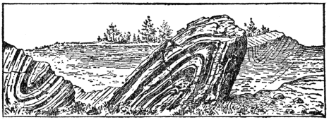
Fig. 8.—An outcrop of stratified crystalline limestone (or marble) exhibiting two small sharp folds—a syncline on the left and an anticline on the right—near Lenox, Mass, These folds developed during the great mountain-making disturbance at the end of the Ordovician period fully 20,000,000 years ago. (After Dale, U. S. Geological Survey.)
From the standpoint of our consideration of slow earth-crust movements, it is important to bear in mind that lateral pressure in the zone of flowage has not only notably deformed rocks, but that, as a result of the buckling forces, given rock masses have, in many cases, been notably shifted downward or upward—mainly upward—from their original positions. Folded strata carrying shells of sea animals are commonly found thousands of feet above sea level in many of the great mountain ranges of the world. During the process of folding on a large scale the crust of the earth is very appreciably shortened at right angles to the direction of applied pressure, due to squeezing or bending of the strata. In the case of the Appalachian mountains of Pennsylvania it has been estimated that such shortening amounts to about twenty-six miles or, in other words, that the strata originally spread out horizontally across an area whose width was about 100 miles have been squeezed or folded into an area whose width is twenty-six miles less.
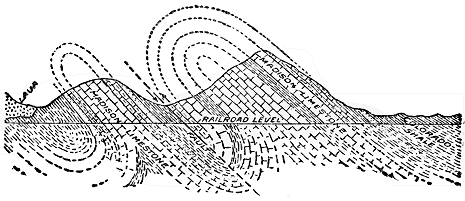
Fig. 9.—Structure section showing the profile of the mountains and relations of rocks below the surface near Livingston, Montana. The strata were crowded together until they bent into great sharply defined folds at the time of the Rocky Mountain Revolution several million years ago. Then the rocks broke along the fault fracture and the mass on the right was shoved over upon the mass on the left. (After U. S. Geological Survey.)
We shall now turn to a consideration of sudden earth movements and some of their effects, including earthquakes. Mention has already been made of the fact that, when pressures and strains are set up in the outer portion (“zone of fracture”) of the earth’s crust, the rocks yield mainly by breaking or fracturing because the rocks not being under a great load of overlying material are there brittle. The earth’s crust has been fractured on small and large scales in many places during the long space of geologic time. Where one block of earth’s crust has slipped or moved past another along a fracture we have what is called a “fault.” Such displacements of rock masses vary in amount from less than an inch to some miles, and they constitute one of the most important features of the architecture of the outer portion of the earth. There are two types of faults fundamentally different as to cause. In one type (so-called “normal fault”) the rocks suddenly yield to a force of tension; a fracture develops and the earth block on one side of the fracture or fault drops with reference to that on the other. In the other type (so-called “thrust faults”) the rocks yield suddenly to a force of compression or lateral thrust, and one block of earth is pushed or thrust partly over another along the surface of fracture or fault. (See Plate 8.)
Faults range in length up to hundreds of miles, those from one to twenty miles in length being very common. Where an earth block has been displaced thousands of feet along a fault surface, it is not to be understood that the whole displacement resulted from a single movement, but rather from a series of sudden movements separated by greater or less intervals of time. Each sudden movement along a fault surface produces a vibration of the earth near by. Many such sudden movements are known to have caused violent earthquakes. Displacements of twenty to fifty feet, as a result of single movements, are definitely known to have taken place in various regions during the last fifty years; and rarely, if ever, has any sudden displacement of as much as several hundred feet occurred. Cliffs and steep slopes very commonly result from faulting, but, because of the long lapse of time required for the repeated movements in the case of great faults, the cliffs or steep slopes begin to wear back and become more or less subdued long before the last of the movements take place. In regions where movements along great faults have long since ceased, the original steep slopes may be completely obliterated by erosion.
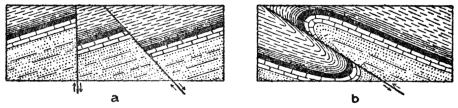
Fig. 10.—Vertical sections through strata illustrating common kinds of faults: a, “normal faults” where one mass simply sinks below another; b, a “thrust fault” where one mass is shoved over another. (After U. S. Geological Survey.)
How does the geologist determine the actual amount of displacement, especially in the case of a large fault in stratified rocks? First, the various formations of the region, where unaffected by faulting, are carefully studied, especially in regard to the character and thickness of each, and their relative geologic ages or normal order as they were deposited one layer above the other. Then, in the simple case of a normal-fault surface at right angles to horizontal strata, it is only necessary to find out what two formations or parts of formations come together along the fault fracture, and the actual amount of displacement is readily determined. Where strata and normal fault surfaces lie at various angles, and also in thrust faults, those angles must be determined in addition to the data above named. In many mining regions, where valuable deposits are affected by faulting, accurate knowledge of the direction and amount of displacements of faults is of great economic importance.
A few examples of normal faults from well-known districts will now be briefly described. The whole eastern front of the central and southern Sierra Nevada Range of California is a great, steep fault slope, from a few thousand to ten thousand or more feet high and hundreds of miles long, of such recent geologic age that it has been only moderately affected by erosion. In fact, it is well known that the southern two-thirds of the range is a great tilted fault block, the total displacement having resulted from repeated sudden movements since about the middle of the present geologic era. A great fault also extends along the eastern base of the great Wasatch Range of Utah and the steep slope thousands of feet high is a fault scarp only slightly modified by erosion. Renewed movements along this profound fault have very recently taken place as proved by the presence of fresh fault scarps in loose deposits which have accumulated across the mouths of some of the canyons, as, for example, near Ogden. In fact, practically all of the north-south ranges of the Great Basin from Utah to California are essentially a series of tilted fault blocks. Another great fault, less conspicuous from the topographic standpoint, is hundreds of miles long in the Coast Range Mountains of California. At the time of the San Francisco earthquake of 1906 there was a renewed sudden movement along this great fracture. The eastern one-half of the Adirondack Mountains of New York is literally a mosaic of hundreds of fault blocks. Many of these faults are from two to thirty miles long and they commonly show displacements of from a few hundred to 2,000 or more feet. A glance at the geological map (in colors) of the vicinity of the great copper mines at Bisbee, Arizona, shows most of that region to contain a network of normal faults which separate it into a mosaic of fault blocks. In each of the examples of faults just given a block of earth has sunk relative to the other, or in other words, each is a “normal fault.”
We shall now turn to some large scale cases of faults in which great masses of earth have been pushed one over another—so-called “thrust faults.” In the southern Appalachian Range, and especially well exhibited in the vicinity of Rome, Georgia, one portion of the mountain mass has literally been shoved over another, at a low angle over a fault surface many miles long, for fully seven miles westward. Both the tremendous weight of rock material actually translated and the number of sudden movements required in the operation stagger the imagination. It is safe to say that during the long time of this great operation violent earthquakes were not uncommon. In the Rocky Mountains of the northern United States and southern Canada there is the greatest known thrust fault on the continent. It is hundreds of miles long, and the actual displacement is commonly at least several miles. In the Glacier National Park of Montana it has been established that the front range portion of the Rockies has actually been pushed at least seven miles, and possibly as much as twenty miles, eastward over a fault surface, and out upon the Great Plains. In some cases rocks of the Prepaleozoic Age have there been pushed upon rocks of the late Mesozoic Age, thus locally upsetting the geologic column.
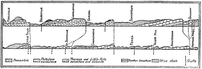
Fig. 11.—East-west profile and vertical structure sections fifty-two miles long in the Mohawk Valley region of New York, showing numerous tilted fault blocks which notably influence the topography. Vertical scale exaggerated. The rocks are Prepaleozoic and early Paleozoic in age. (Modified by the author after Darton, New York State Museum.)
The Wasatch Range of Utah, in addition to the great normal fault along its western base, contains a remarkable system of thrust faults. In the region now occupied by the Wasatch Mountains a number of parallel (thrust) faults were developed close together and the broken pieces of the earth’s crust between them were pushed up, the rocks on one side of each crack riding up over those on the other side until a great mountain range was formed where once lay a plain. In the Ogden Canyon one great earth block of Prepaleozoic (Algonkian) Age has been shoved thousands of feet over late Paleozoic (Carboniferous) rock, which latter has in turn been thrust over early Paleozoic (Cambrian) rock. This thrust faulting was accomplished before the development of the geologically recent normal fault along the western base of the range.
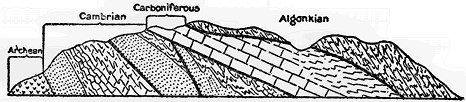
Fig. 12.—Vertical (structure) section through a part of the earth’s crust several miles long in Ogden Canyon, Utah, showing the system of great thrust faults. Prepaleozoic (Algonkian) rocks have been pushed far over upon late Paleozoic (Carboniferous) strata, which latter have in turn been shoved over early Paleozoic (Cambrian) strata, etc. (After U. S. Geological Survey.)
Any sudden movement of part of the crust of the earth, due to a natural cause, produces a trembling or shaking called an earthquake. Though earthquakes are generally classed among the most terrifying of all natural phenomena, those which have occurred during human historic times have had scarcely any geological or topographical effects of real consequence on the face of the earth. Locally, the effects may be notable and the destruction of life and property may be great. The earth may be locally cracked and rent, small fault scarps may develop, landslides and avalanches may result from the shaking of the earth, buildings may be demolished, and sea waves may be rolled upon the land. On the other hand, many earthquakes, called “tremors,” are too slight to be noticed by people, though they are recorded by specially constructed instruments called “seismographs.” We have already stated that actual sudden displacements causing earthquakes have amounted to twenty or even fifty feet right along fault fractures, but during the vibrations or quakings, which are often so destructively sent out into the neighboring country, the earth’s surface rarely actually moves more than a small fraction of an inch. Because of the suddenness of the movement objects on the surface may be moved inches or even feet. Violent shocks may last one or two minutes and cause the whole earth to tremble, though at distant points only seismographs record the movement. It is probably true that some part of the earth is shaking all the time.
Studies during the last fifty years have made it certain that the main cause of earthquakes is the sudden slipping of earth blocks past each other along fault fractures, the sudden slipping furnishing the impulse which sends out the vibrations into the surrounding more or less elastic crust of the earth. The low rumbling to roaring sound, which sometimes immediately precedes an earthquake, is probably due to the grinding of the rocks together below the surface.
Earthquakes generally accompany volcanic outbursts of the violent or explosive type, and in such cases subterranean explosions cause both the eruptions and the quakings of the earth. It is well known that the principal volcanic districts or belts of the earth are also the belts of most frequent earthquakes, but this does not mean that volcanic action causes most of the earthquakes. Active volcanoes and earthquakes are so commonly associated in the same belts because those belts no doubt represent portions of the crust which are now most actively yielding to the forces directly resulting from the shrinkage of the earth. Within the volcanic belts many earthquakes take place unaccompanied by any volcanic action, and many others take place far from volcanoes. Some earthquakes have been caused by the impact of great landslides or avalanches, or by the sudden caving in of underground openings.
Brief descriptions of a few typical carefully studied earthquakes during recent years will serve to make the main features of earthquakes still clearer to the reader.
The violent Japanese earthquake of 1891 was caused by the sinking of a block of earth forty miles long from two to thirty feet below that on the other side of a fault fracture. There was also considerable horizontal shifting, and cracks developed in the adjacent region. A distinct fault scarp, fifteen to twenty feet high, developed, and in some cases extended right across cultivated fields.
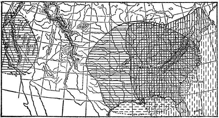
Fig. 13.—Map of the United States, showing the large areas over which three of the greatest of our earthquakes were actually felt by people. These earthquakes were recorded in many parts of the world by delicate instruments: New Madrid, 1811; Charleston, 1886; San Francisco, 1906.
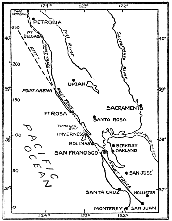
Fig. 14.—Sketch map showing the trace of the great fault fracture along which a renewed sudden movement of as much as twenty feet took place to cause the San Francisco earthquake of 1906. (After U. S. Geological Survey.)
The San Francisco earthquake of 1906 was produced by renewed movement along the great fault which extends lengthwise through the Coast Range Mountains for several hundred miles. It is literally correct to say that, for 250 miles along this great earth fracture, one part of the Coast Range instantaneously slipped from two to twenty-two feet past the other. More or less of the movement extended at least several thousand feet down into the earth. In this case both sides slipped and the movement was very largely horizontal rather than vertical. The land on the east side of the fault moved south and that on the west side moved north, the amount diminishing away from the fault on each side so that some miles out the actual crustal movement was only a few inches. When one thinks of the tremendous volumes of earth material involved in this shifting of the earth’s crust, is it any wonder that such destructive earthquake waves were produced? Many buildings were wrecked, several hundred people were killed, the disastrous San Francisco fire resulted, water mains were broken, and fences and roads crossed by the fault were dislocated as much as fifteen to twenty feet.
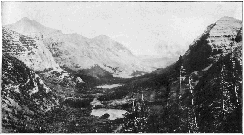
Plate 5.—Swift Current Valley in Glacier National Park, Montana. This was once a deep V-shaped canyon carved out (eroded) by stream action. Then a great valley glacier slowly plowed its way through it during the Ice Age and, by ice erosion, the present nearly straight U-shaped canyon has resulted. (Photo by Campbell, U. S. Geological Survey.)
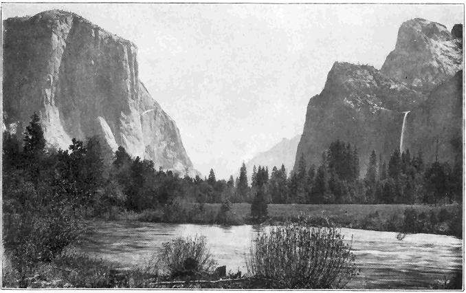
Plate 6.—View in the Yosemite Valley from Near the Western Entrance. The great rock called “El Capitan,” on the left rises 3,500 feet above the river, and Bridal Veil Falls on the right is 620 feet high. All the rock is granite, the nearly vertical walls of which have resulted from the action of a great glacier which plowed its way through the valley during the Ice Age; the valley walls have been cut back by the removal of large vertical joint blocks. The flat bottom of the valley has resulted from the filling with sediment of a postglacial lake in the valley. (Photo by F. N. Kneeland, Northampton, Mass.)
During the great earthquake on the coast of Alaska in 1899 notable changes took place along the shore for some miles, one portion having suddenly risen as much as forty-seven feet, while another portion sank below sea level.
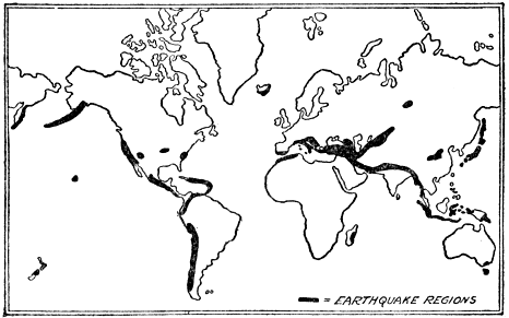
Fig. 15.—Map showing the principal earthquake regions of the world.
In 1886 the earthquake centering near Charleston, S. C., was preceded by rumbling and roaring noises and the slight quaking increased to violent shaking which lasted more than a minute. Eight minutes later a rather violent earthquake shock took place, followed during the next ten or twelve hours by less severe shocks. Most buildings in the city were wrecked or more or less badly damaged, and some people were killed. The shocks were so violent that the quaking was actually felt by people over an area of more than 2,000,000 square miles, the disturbance having spread at the rate of about 150 miles per minute. Near Charleston openings and fissures were formed through which sand and muddy water were ejected, but the cause of the disturbance was most likely slipping of the old very hard rocks below the loose deposits of the Coastal Plain.
From 1811 to 1813 a series of violent earthquakes developed in the general vicinity of New Madrid, Missouri. In an area of over 2,000 square miles, now called the “sunk country,” many portions suddenly sank giving rise to small fault scarps or cliffs, and various lake basins were formed. Development of a fissure caused a local change in the course of the Mississippi River.
In 1897, Assam, India, was shaken by an earthquake of unusual magnitude, which lasted 21/2 minutes. An area of 150,000 square miles was disastrously shaken, and the shocks were distinctly felt over an area of 750,000 square miles. A number of notable fault scarps developed, the movement on one having been thirty-five feet.
CHAPTER VIII
VOLCANOES AND IGNEOUS ROCKS
N
NOT only because of the great power and terrifying grandeur of violent eruptions, but also because of their destruction of life and property, volcanoes stand out in the popular mind as among the most real and important of all geological phenomena. But great volcanic outbursts, like violent earthquakes, are in truth only outward, sensible, relatively minor manifestations of the tremendous earth-changing forces below the surface. They are far less important as geological agencies than the mighty interior forces which cause parts of continents to be slowly upraised and the rocks folded, or even than the incessant action of streams whereby the lands are cut down. Even as an igneous agency, volcanoes are notably less important than the development and shifting of molten materials within the earth’s crust. Volcanic action is, however, not only conspicuous, but it is also of real significance as a means of changing the earth, such action having taken place since very early known geologic time. After bringing out the main facts and principles of volcanoes, aided by descriptions of specific eruptions, we shall turn to a consideration of igneous activity within the earth’s crust.
Mount Vesuvius in Italy is perhaps the most famous active volcano in the world. Its eruptions have been more or less carefully studied for a longer time than any other. The eruption in the year 79 A. D. was really a tremendous explosion causing a large part of the old crater to be blown away, and sending immense volumes of rock fragments, mostly finely divided (so-called “ashes”) into the air which completely buried the small city of Pompeii. Water from the great clouds of condensing steam, mixed with “ashes,” formed muddy floods which overwhelmed Herculaneum. Little or no lava was erupted. Since that time the crater has been more or less active and the present cone, 4,000 feet high, has been built up. During the last fifty years the greatest eruptions took place in 1872 and 1906, when, streams of molten rock flowed down the sides of the mountain.
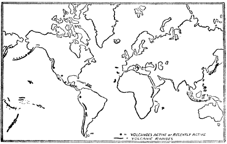
Fig. 16.—Map showing the distribution of active and recently active volcanoes of the world.
One of the greatest volcanic explosions ever recorded was that of the island of Krakatoa, between Sumatra and Java, in 1883. The greater part of the island was blown away and there was water 1,000 feet deep, where just before the island stood hundreds of feet high. About a cubic mile of rock material was sent into the air mostly in the form of fine dust—some of it for seventeen miles—and completely hid the sun, causing total darkness during the eruption. Dust fell over an area of several hundred thousand square miles. Several days after the explosion ships more than 1,000 miles away were dust covered. Such enormous quantities of a light porous lava called “pumice” fell and floated upon the sea that navigation was badly obstructed many miles from the volcano. Extremely fine dust gradually spread through the whole earth’s atmosphere, causing the extraordinary red sunsets for several months. The sound of the explosion was heard for hundreds of miles. Great sea waves 50 to 100 feet high were stirred up and they swept inland for several miles over the low-lying coast lands of neighboring Java and Sumatra, overwhelming hundreds of villages and drowning tens of thousands of people.
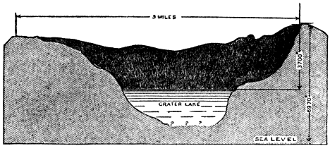
Fig. 17.—The great hole left after the top of Mt. Katmai in southern Alaska was blown off in 1912 by one of the most tremendous volcanic explosions in the annals of human history. The water in the lake is hot. (After Griggs, National Geographic Magazine.)
One of the greatest explosions on record was that of Katmai volcano, several thousand feet high, on the coast of Alaska, in June, 1912. Not only was the top of the mountain completely blown off, but also a great crater pit, three miles wide across the top and several thousand feet deep, was developed in the stump of the former mountain. Volcanic dust fell to a depth of several feet within twenty-five to fifty miles of the mountain. Dust accumulated to a depth of nearly a foot in the village of Kodiak, 100 miles east of the mountain, where total darkness prevailed for more than two days. A lake of very hot water now occupies the bottom of the great new crater. The noise of the explosion was heard for at least 750 miles.
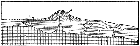
Fig. 18.—Diagrammatic vertical or structure section through a portion of the earth illustrating the common modes of occurrence of igneous rocks. P, deep-seated (plutonic) igneous rock; S, strata; D, dikes; M, mass of igneous rock forced between strata bending them upward; F, feeding channel of volcano; V, volcano; L, lava sheets. (By the author.)
One of the most frightful volcanic catastrophes of recent years was the eruption of Mont Pelée, island of Martinique, West Indies, in 1902. In this case, also, no lava was poured out, but violent explosions sent great clouds of very highly heated gases and vapors, mingled with incandescent dust, thousands of feet into the air. One of these great clouds rushed down the mountain at hurricane speed and destroyed the city of St. Pierre with its 30,000 inhabitants. After the main eruption a spine or core of hard rock began to rise out of the crater and it slowly grew to a height of 1,000 feet in several months, after which it began to crumble away. This spine probably represented nearly frozen lava which solidified as it was gradually forced out of the mountain.
Of special interest to us, though not of great importance is the only active volcano in the United States. In May, 1914, Mount Lassen (or Lassen Peak), a long inactive volcano in northern California, suddenly burst forth explosively and during the next several years hundreds of eruptions occurred. Little or no lava appeared, but great clouds of steam and dust often shot into the air from one to three miles above the top of the mountain, which lies over 10,000 feet above sea level. (Plate 10.) Great quantities of dust have accumulated for miles around the mountain. At this writing (October, 1920) the mountain is again active.
It should not be presumed, however, that all, or nearly all, volcanoes are of the explosive type. Others of the more quiet type are well exemplified by the two great Hawaiian volcanoes, Mauna Loa and Kilauea. Any but relatively very minor explosions rarely, if ever, occur, the product of such volcanoes being almost wholly lava, which flows down the mountainsides in molten streams. The Hawaiian Islands have, in fact, been almost entirely built up by successive eruptions of lava, the building-up process having begun well below sea level. Mauna Loa rises to nearly 14,000 feet above the sea, but, due to the fact that the streams of lava have spread so far, the mountain has an exceptionally low angle of slope which makes it difficult to realize that it is so high. Considering its submarine portion, Mauna Loa really rises nearly 30,000 feet above the sea floor. Although Kilauea lies nearly 4,000 feet above sea level on the flank of Mauna Loa, and only twenty miles distant from it, the two volcanoes are singularly independent in regard to their eruptions. Each mountain has a crater irregularly oval in shape, nearly three miles long, bounded by almost vertical walls of hard lava, in some cases arranged in terraces. The floors of the great crater pits are relatively level, and consist of black lava in which are lakes of molten and even boiling lava. The black lava floor is, in each case, only a frozen or hardened crust upon a great column of molten lava extending down into the mountain. Prior to an eruption of Mauna Loa the lava column rises hundreds of feet in the crater, but during recent years the lava seldom, if ever, flows out over the crater rim. Instead, it breaks through the mountainsides at various altitudes, the great flow of 1919 having started at an altitude of about 8,000 feet. This stream of liquid rock, fully one-half of a mile wide, flowed for weeks down the mountainside and into the ocean, the waters of which, in contact with the highly heated lava, were thrown into terrific commotion. In 1885 a stream of lava several miles wide flowed forty-five miles. In one case, lava traveled the first fifteen miles in two hours, but this is an unusually great rate of speed. Lava streams in general seldom move faster than one or two miles per hour, and as the liquid rock gradually cools and becomes more and more viscous, the speed diminishes to zero. Almost incredible volumes of steam emanate from streams of molten lava.
In 1840 an outflow of lava took place from the side of Kilauea Mountain and ran into the sea. Since that time the floor of the great crater pit (quoting Professor W. H. Hobbs) “has been essentially a movable platform of frozen lava of unknown and doubtless variable thickness which has risen and descended (hundreds of feet) like the floor of an elevator car between its guiding ways. The floor has, however, never been complete, for one or more open lakes are always to be seen, that of Halemaumau, located near the southwestern margin, having been much the most persistent. Within the open lakes the boiling lava is apparently white hot at a depth of but a few inches below the surface, and in the overturnings of the mass these hotter portions are brought to the surface and appear as white streaks marking the redder surface portions. From time to time the surface freezes over, the cracks open and erupt at favored points along the fissures, sending up jets and fountains of lava, the material of which falls in pasty fragments that build up driblet cones. Small fluid clots are shot out, carrying threadlike lines of lava glass behind them, the well-known “Pelée’s hair.” Sometimes the open lakes build up congealed walls, rising above the general level of the pit, and from their rim the lava spills over in cascades to spread out upon the frozen floor.”
In some regions, like the Columbian Plateau of the northwestern United States and the Deccan of India, each covering about 200,000 square miles, vast quantities of lava have been poured out layer upon layer to depths of even thousands of feet. Distinct volcanic cones or mountains in those regions are either absent or too scarce to look to as sources of so much lava. Such lava floods were probably mostly erupted from great fissures in the earth’s crust, the fluidity to spread many miles.
Some idea of the quantitative geological importance of volcanism may be conveyed to the reader when we assert that, according to a conservative estimate, fully one-half of a million cubic miles of molten rocks have been poured out upon the surface of the earth through volcanic action in relatively recent geological time! The Cascade Range with its lofty peaks, including Mount Shasta and Mount Rainier, each rising more than 14,000 feet above the sea, has been built up very largely by volcanic action during the last era of geologic time. Many other mountain peaks and various ranges have been similarly developed either wholly or in part. The great chain of Aleutian Islands extending hundreds of miles into the sea, is the scene of much volcanic activity where a great mountain range is now literally being born out of the sea by the processes of vulcanism.
Before this the reader has more than likely wondered about the source of the heat, vapors (mainly water), and power involved in volcanic action. Answers to these questions are closely tied up with the precise cause (or causes) of volcanic action which remains one of the most uncertain of the larger problems of geologic science. Before briefly discussing the causes, a few additional facts should be stated. First, in regard to the heat, a careful determination of the temperature of the molten lava of Kilauea in 1911 showed it to be 1,260 degrees Centigrade, or 2,300 degrees F. This is, however, a relatively low temperature, because many lavas from other regions show melting points all the way up to at least 2,000 degrees Centigrade (3,600 degrees F.). Water in the form of steam is quantitatively one of the greatest products of volcanoes. A fair idea of the tremendous volumes of water involved may be gained from the statement that a careful estimate shows that fully 460,000,000 gallons of water in the form of steam erupted from a single secondary cone of Mount Etna during a period of 100 days. Among other gases which are given off in greater or less amounts during volcanic activity are carbonic acid gas, sulphureted hydrogen, sulphur dioxide, and hydrochloric acid. Some idea of the power back of volcanoes may be gained not only from the tremendous explosions such as those above described, but also from the fact that the pressure necessary to raise the column of lava from sea level to the top of Mauna Loa (nearly 14,000 feet) is about 1,150 atmospheres, or about 17,000 pounds per square inch. The actual pressure must there be much greater because the lava is forced up from far below sea level.
A long-held idea that a relatively thin crust covers a molten interior, and that downward pressure of this crust due to earth contraction causes molten rocks to be forced out, has been too thoroughly disproved to now be at all seriously entertained. The fact that near-by volcanoes commonly erupt entirely independently, as in the case of Mauna Loa and Kilauea, shows that there can be no universal liquid beneath a relatively thin crust. Other arguments against liquidity of the earth’s interior are that the earth acts like a body nearly as rigid as steel against the powerful tide-producing forces, and that earthquake waves which pass through the earth to a depth of at least 2,000 miles are the kind which require a solid medium for transmission.
Let us then briefly consider more plausible views regarding the cause of volcanic action. First of all we may be sure that the earth is highly heated inside. Measurements in many deep borings show that the temperature increases at the rate of about 1 degree F. for each 50 to 60 feet downward, to depths greater than a mile. Accordingly, on the basis of 1 degree rise in 50 feet, at depths of 20 to 35 miles, the temperature must be great enough (2,120 degrees to 3,590 degrees F.), to cause all ordinary rocks to melt if they were at the surface. At such depths, however, the downward pressure upon the rocks is so great that their melting points are notably raised, and there is every reason to believe that under ordinary conditions the rocks 20 to 35 miles down are not molten. If we adhere to the older (nebular) hypothesis of earth origin, the interior heat of the earth is left over from the cooling, once molten, earth. On the basis of another (planetesimal) hypothesis, the earth’s heat is due to the steady, powerful action of gravity causing the earth to contract. In any case, the earth is hot inside as proved by deep well records and igneous phenomena in general, and it is a contracting or shrinking body as proved by the many large scale zones of wrinkling or folding of rocks. If, then, highly heated solid rocks at reasonable distances down in any part of the earth are subjected to relief of pressure by an earth movement such as upward crumpling of the crust, or by readjustment of large fault blocks, such heated solid rocks would become molten. The very earth movement which brings about relief of pressure and melting may very reasonably be regarded as the power which forces some of the newly formed molten material higher up into the earth’s crust, and even out upon the surface. This view harmonizes with the well-known fact, already mentioned, that the main belts of active volcanoes are also the main belts of active earth movements, such as earthquakes.
Another source of power behind volcanic action is steam pressure. We have already mentioned the fact that vast amounts of water in the form of steam escape from volcanoes or even from streams of molten lava. The violent volcanic explosions are quite certainly all, or nearly all, direct results of sudden giving way of volcanoes to steam pressure which accumulates during greater or less periods of time, and with little or no possibility of escape, without rupturing the mountain. Steam alone, or combined with some of the other gases so common as volcanic products, may also aid in forcing out molten rock. What is the source of the steam and other gases or vapors? According to one view they were originally in the earth, while according to another view the water at least has been absorbed by the molten rocks from surface waters which worked their way downward. At least two arguments oppose the second hypothesis: first, that not a few volcanoes are really many miles from the sea or other bodies of water, while downward percolation of rain water would fall far short of supplying the tremendous quantities of water ejected, and second, any water taken up by molten rock must be absorbed within a very few miles of the surface because, as we have learned, farther down there are no openings large enough to permit the downward passage of water, but, as a matter of fact, the very upper part of the earth’s crust is just the place where molten rocks begin to give up their water, often with terrific violence.
We may now turn to a consideration of the other very important kind of igneous activity, namely, the rise and transfer of molten materials within the earth’s crust, but not to the surface. The quantity of such deep-seated (so-called “plutonic”) igneous rock material which has been intruded into the earth’s crust within known geologic time, is far greater than that which has been forced to surface, that is the so-called “volcanic” material. The plutonic rocks are always thoroughly crystallized, and they are generally coarser grained than the volcanic rocks.
Where molten materials have been forced into cracks or fissures in the crust of the earth and there congealed, we have a very common mode of occurrence called “dikes” (Plate 9). In many regions often one set of dikes was formed, after which one or more succeeding injections from the same or different deep-seated bodies of molten rock took place, and some of the later dikes were forced to cut across earlier ones. Dikes of all lengths up to at least thirty miles, and of all widths up to many hundreds of feet, are known, but they are generally less than a mile long and not more than a few feet or rods wide. They have been intruded into all kinds of rock formations—igneous, sedimentary, and metamorphic. Dikes are common in many parts of the world and they often excite the interest of lay-men. They are wonderfully displayed along the southern coast of Maine. Plate 9 shows small dikes where the molten material was forced from a larger mass into a body of older dark rock. The Palisades of the Hudson River, just north of New York City, consists of a layer of igneous rock several hundred feet thick which, in the molten condition, was forced nearly horizontally between layers of sandstone millions of years ago, that is in the early Mesozoic era. The palisade or columnar structure was caused by cracking of the rock during the cooling and contraction. This is the explanation of most columnar structures of igneous rocks, exceptionally fine exhibitions being at the Giant’s Causeway in Ireland, and Devil’s Tower, Wyoming (Plate 10).
A type of occurrence not so common, but of special interest, is where a body of molten rock rising in nearly horizontal strata becomes cooler and therefore stiffer or more viscous and, losing its power to penetrate, forces its way between the layers causing the strata to be arched or domed over it. Sufficient removal of overlying material by erosion has revealed many fine examples of this type of occurrence.
Another type of interest is the volcanic neck, which is the core or plug filling the feeding channel of a volcano. In certain regions, like parts of Arizona and New Mexico, extinct volcanic mountains may be all cut away by erosion, except the central cores or necks which, both because they are more resistant and are last to be reached by erosion, stand out conspicuously as great towers on the landscape (Plate 9).
Most important of all from the quantitative standpoint, however, are the great bodies of igneous rocks, ranging up to many miles across, which, in a molten condition, were forced irregularly into the earth’s crust from unknown depths.
The common rock called granite belongs in this category of rocks, which are the best and most extensively developed of all igneous types. The roots or cores of great mountain ranges often consist of such rocks which are exposed to view only after removal of great thickness of overlying material. Immense areas of granite and other plutonic rocks of extra deep-seated origin are exposed, because of removal of overlying material by erosion, in southeastern Canada, the Adirondack Mountains, New England, the Piedmont Plateau of the Atlantic Coast, and in the Sierra Nevada Mountains. All the rock forming the lofty walls of Yosemite Valley is granite, which was forced into the earth’s crust in relatively late Mesozoic time, and which has since been laid bare by erosion.
CHAPTER IX
WATERS WITHIN THE EARTH
I
IT has been estimated that approximately 1,500 cubic miles of water fall upon the surface of the United States each year. About one-half of this goes back into the atmosphere by evaporation; about one-third of it flows away in surface streams; and the remaining one-sixth enters the crust of the earth. Considerable water which enters the earth returns to the surface as springs, by capillarity of soils and rocks, or by being drawn up into plants and evaporated. Some idea of the amount of ground water may be gleaned from the statement, based upon a careful estimate, that all the water in the rocks and soils of the first 100 feet below the surface of the United States would make a layer seventeen feet thick. In most humid regions the soils and loose rock formations are saturated with water at greater or less depths (usually less than 100 feet) below the surface. The surface of this saturated layer is called the ground-water level, or more familiarly the “water table.” The water table shifts up and down more or less according to variation in rainfall.
In addition to the water held in the loose rocks and soils near the earth’s surface, large quantities occur in definite layers (usually strata) of porous rocks which very commonly extend at various angles, hundreds or even thousands of feet into the earth. A very fine illustration of this principle is the case of the Dakota sandstone formation of Nebraska. Almost anywhere across the State a well drilled through a bed of clay and into the porous sandstone layer encounters water. (Figure 19.) Another principle is also well illustrated, namely, that water in such a porous layer may actually travel hundreds of miles, water obtained from a well sunk to the Dakota sandstone having actually traveled under the surface of the State all the way from the eastern face of the Rocky Mountains, where rain and melting snow entered the upturned and exposed porous rock layer. Another good example is Iowa, where certain porous rock layers outcropping in the northwestern and northeastern corners of that and adjacent States gradually bend down under the State, reaching the greatest depths (up to 3,000 feet) far in the interior. From wells 3,000 feet deep near Boone, Iowa, it is, therefore, a fact that some of the water pumped out of the earth actually traveled underground all the way from beyond the corners of the State. This sort of travel of underground water is common in many parts of the world. It should be clearly understood that such water does not flow freely as in a pipe along subterranean passageways, but rather it slowly works its way between the grains of porous rock. Where such water moves distinctly downward, and the porous layer has both above and below it an impervious rock layer like shale or clay, it gradually gets under greater and greater pressure. In some cases such pressure has actually been found by deep drilling to be equivalent to that of a column of water several thousand feet high. The rate of motion of water in porous underground rock layers is very slow, data from various sources indicating a rate of speed of not more than one-fifth of a mile a year in coarse porous sandstone, while in many rocks it cannot be more than ten to fifty feet per year.
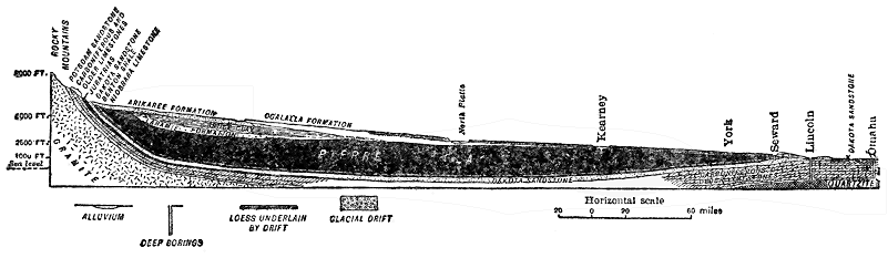
Fig. 19.—Vertical (structure) section from the Rocky Mountains to Omaha, Nebraska, illustrating a widespread underground porous rock layer (the Dakota sandstone) charged with water under pressure, the clay formation acting as a cap rock. (After Darton, U. S. Geological Survey.)
We still have to consider a third mode of occurrence of waters within the earth. Many formations, like granite and other types of crystalline rocks are neither in definite layers, nor are they sufficiently porous to allow water to really flow through them. Where such rocks extend far down from or near the surface, how does rain water descend? It does so along cracks or fractures (both joints and faults) which we have learned are almost universally abundantly present in all hard rocks in the upper (or zone of fracture) portion of the earth’s crust. Joint cracks are generally very irregular in direction and spacing, while fault fractures are usually fairly regular and straight. Many cracks are not wide enough to allow anything like good passageways for water, while others are sufficiently open to allow water to travel along them for hundreds, or even thousands of feet. In canyons of the West, springs not rarely emerge from the bottoms of great, nearly vertical ledges of granite and other hard crystalline rocks, the waters certainly having entered the rocks hundreds, or even some thousands of feet, higher. In rocks of the kind here considered it is evident, then, that the movements of subterranean waters must be mostly exceedingly irregular and usually not in great quantities. In many deep mines of the world, underground water causes little or no trouble except often near the surface. Occasionally a shaft or tunnel strikes a prominent joint or fault fracture filled with water.
What we might really call underground streams may occur only under exceptional conditions in rocks other than limestone, but in limestone they are not uncommon because the slow solubility of the rock allows underground waters to slowly enlarge the passageways to form distinct channels. Echo River, which flows through Mammoth Cave, is a fine case in point.
Most water by far which emerges as springs, was at one time surface water. A simple, but common case is where rain water soaking through porous soil (e.g., sand) or rock, sinks to the top of an underlying impervious layer (e.g., clay) along whose surface it flows until it reaches the side of a valley where a spring results. In fact, wherever the water table is crossed by the surface of the ground, water must either seep or flow out. Where underground streams which are common in limestone regions reach the surface on hill or valley sides, springs result. Another source of springs is where under proper conditions of slope a porous rock layer, charged with water well below the surface, appears at a lower level than its source of water. Still another type of spring is where a fissure or fracture crosses a water-bearing layer in which the pressure is great enough to cause the water to rise to the surface along the relatively open fissure or fracture.
In various localities we hear of springs in seemingly paradoxical situations on tops of hills and even mountains. Such a mystery is not difficult to clear up. In the first place, such springs are rarely at the summit of the hill or mountain. A case well known to many persons is the small, but never-failing spring a little below the summit of Mount Whiteface, a peak in the Adirondacks, rising 3,000 feet above the general level of the immediately surrounding country. In this case, a mass of highly fractured rock, subjected to much rainfall and lying above the level of the spring, is sufficiently large easily to contain and give forth enough water to account for several such springs. In rare cases, however, springs or flowing wells are located on summits, and in such places it is only necessary to bear in mind some of the principles above set forth, but mainly the facts that water may travel under pressure long distances underground, and that the point of emergence may be on a hill which is actually lower than the source of the water far away.
The economic significance of underground waters is forcibly brought to our attention when we realize that 75 per cent of the people of the United States depend upon wells for their water supply. Many city supplies, most farm supplies, and much irrigation water come from wells. The 3,000,000 people of Iowa, for example, are dependent upon underground waters from wells varying in depth from a few feet to several thousand feet.

Fig. 20.—Ideal section illustrating the chief requisite conditions of artesian wells. A, a porous stratum; B and C, impervious beds below and above A, acting as confining strata; F, the height of the water level in the porous bed A, or, in other words, the height of the reservoir or fountainhead; D and E, flowing wells springing from the porous water-filled bed A. (After U. S. Geological Survey.)
Most wells are simply dug to depths a little below the water table. In humid climate regions the depths seldom exceed fifty feet. The water encountered in such wells is rarely under pressure. In some regions of deep soils or loose formations, wells are actually bored with an auger to depths of as great as 200 feet. Deep wells in relatively hard rocks are always drilled to depths of even thousands of feet. In such cases the purpose is to strike either a porous rock layer charged with water, or a crack or fissure filled with water, the water almost always being under pressure (sometimes very great), under such conditions. These are called artesian wells whether the water under pressure actually flows out at the surface or not.
We may now inquire as to the necessary conditions for artesian wells. This may best be done by the aid of diagrams. Figure 20 illustrates a very common case where a porous layer, lying between impervious layers, passing under a valley, comes to the surface of the hills on each side where the water enters the porous layer. On sinking a well to the water-charged layer, the water rushes through the hole to a greater or less distance above the surface. In Figure 21 the porous and impervious layers are simply tilted, and the water under pressure rises through the free opening to the surface. Wells of this kind are also common in the Atlantic Coastal Plain of the United States. In another case, less comprehensible to the layman, the porous water-bearing stratum curves downward under a hill or mountain, water entering it where it is exposed on each side. Under such conditions a flowing artesian well cannot be drilled at or near the summit, but since the water is under pressure it will rise in the hole to a level approaching that of the lowest part of the outcrop of the porous layer on either side of the hill or mountain. This is essentially the condition of things toward the interior of Iowa, where water from the deeper wells rises 2,000 feet or more in the holes, but does not reach the surface.

Fig. 21.—Section illustrating the thinning out of a porous water-bearing bed. A, inclosed between impervious beds B and C, thus furnishing the necessary conditions for an artesian fountain at D. (After U. S. Geological Survey.)
The drilling of deep wells, where records, including samples of rock materials brought up, have been kept, has been a great aid to the geologist in determining, or rendering more precise, the knowledge of not only the kinds of rocks underground, but also the thicknesses and structural relations of the formations.
In yet another way deep wells are of special significance, that is in regard to the light which they throw upon the subterranean temperature of the earth. Very recently the deepest well in the world was drilled near Fairmont, West Virginia, to a depth of 7,579 feet, in quest of oil or gas. At a depth of 7,500 feet, the temperature was found to be 168 degrees F. Allowing for a near-surface temperature 50 degrees, this means an average rate of increase downward of 1 degree in 62 feet. The second deepest well is near Clarksburg, West Virginia, sunk to a depth of 7,386 feet, with a temperature of 172 degrees at the 7,000-foot level, or at the rate Of 1 degree in 57 feet, allowing for a near-surface temperature of 50 degrees. It is a remarkable fact, that little or no water was encountered all the way down. A well 7,348 feet deep in southeastern Germany gave a temperature of 186 degrees at the bottom, or a rate of increase of 1 degree in 54 feet. These three records are about the average for the deep holes of the world. Next to the deepest mining shafts in the world are in the copper mining region of northern Michigan, where over 5,000 feet (counted vertically, not down the slope) down the temperature is nearly 90 degrees the year round. The rate of increase is here less than in most wells of such depth, because of the cooling air currents. Many years ago a rather remarkable experiment in well drilling was tried by the city of Budapest, Hungary, the attempt being to get a supply of water at the brewing temperature of 176 degrees in order to encourage the manufacture of beer. After getting a good supply of water at a depth of 3,120 feet and a temperature of 158 degrees, work was stopped. In building the two great tunnels (St. Gotthard and Simplon) through portions of the Alps, such high temperatures were encountered that work was continued only under great difficulties. In the famous Comstock gold and silver mine of Nevada, over forty years ago, temperatures as high as 157 degrees were encountered in the shafts at a depth of only 2,000 feet or a little over, the exceptional temperature for such depth no doubt being due to occurrence of the ores in geologically recent igneous rocks which have not yet cooled to the normal temperature for the depth of 2,000 feet.
From the sanitary standpoint, wells are of very great significance, especially in view of the fact that such a large proportion of people depend upon well water. It is generally understood that typhoid fever is more common in the country than in cities, in spite of what might reasonably be expected. What are some of the causes leading up to such a situation? The idea that water purifies itself after flowing a relatively short distance is, in many cases, far from being true, especially when we are dealing with underground water. Actual observations prove that germ-laden water may travel surprisingly far underground. Germ-laden water from barns, cesspools, or outhouses spreads notably on sinking to the water table and it is easy to see how so many wells become contaminated. On general principles, a geologist is especially wary of water from a well in a barn yard. The well for human use at least should be located out of reasonable range of such contamination. Under the condition of the diagram a well or spring some distance down the side of the hill may actually be unfit for use, though a serious situation is much less likely to develop there. Nor should one assume that by locating the well on the uphill side of the house, and the outhouses or cesspool on the downhill side, safety is assured. From what we have learned in regard to earth movements, and the tilting of strata from their original positions, we know how the movement of water in the saturated zone near the surface may be downhill roughly following the hill slope, while in a tilted porous layer of rock farther below the surface the movement of water may be in just the opposite direction. A well drilled into the solid rock for safety on the uphill side of a house might derive its water from this very same porous layer, whose water has been contaminated from a cesspool or other source down the side of the hill. Such a case is by no means a theory or a rarity. There is also real danger of contamination in cases where the water flows more like streams underground through cracks or fissures in hard or dense rocks, or through channels developed by solution in limestone. It may happen that water becoming contaminated from barn sites, cesspools, or outhouses finds its way along such a channel to the side or bottom of a well. The author well remembers the case of a farmer whose house, barn, and well were close together on a little limestone terrace and who continued to use the well water although he complained of its disagreeable taste, especially after a rain when he could “taste the barn in it.”
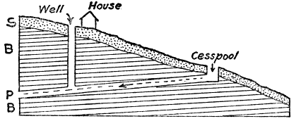
Fig. 22.—Diagram illustrating a danger of contamination of wells by impure underground water. S, soil; B, bedrock; P, porous stratum. Impure water from cesspool moves through porous layer to bottom of well. (By the author.)
Finally, in this connection, it may be said that wells should be located in the light of the principles above explained, best of all upon the advice of some one with geological training, and that, to insure safety to health from the well water, sanitary analyses (at small cost) should be made once or twice a year. A bad well should be abandoned and a new one sunk.
A large amount of money has been wasted upon, and much mystery and superstition has surrounded so-called “water witches,” or those who claim some special or supernatural power of locating supplies of underground water. Most common of all devices used is the so-called “divining rod,” which is a forked stick of willow, witch-hazel, or other wood, according to the seemingly special requirement of the operator. Certain mechanical and electrical devices are also employed. With one fork of the divining rod grasped in each hand and the main part of the stick upright, the operator walks about until, due to some “mysterious” influence, a place is found where underground water pulls the upright portion of the stick downward in spite of the grasp of the holder. Some operators even claim to know just how deep a well must be sunk. Without any attempt to question the honesty of all operators, geologists are in full accord with the following quotation from a paper published by M. L. Fuller, for the United States Geological Survey: “The uselessness of the divining rod is indicated by the facts that it may be worked at will by the operator, that he fails to detect strong water currents in tunnels and other channels that afford no surface indications of water, and that his locations in limestone regions where water flows in well-defined channels are no more successful than those dependent upon mere guesses. In fact, its operators are successful only in regions in which ground water occurs in definite sheets in porous material, or in more or less clayey deposits, such as pebbly clay or till. In such regions (which are extremely common) few failures can occur, for wells can get water almost anywhere. Ground water occurs under certain definite conditions, and just as surface streams may be expected wherever there is a valley, so ground water may be found where certain rocks and conditions exist. No appliance, either mechanical or electrical, has yet been devised that will detect water in places where plain common sense will not show its presence just as well. The only advantage of employing a “water witch,” as the operator of the divining rod is sometimes called, is that crudely skilled services are thus occasionally obtained, since the men so employed, if endowed with any natural shrewdness, become, through their experience in locating wells, better observers of the occurrences and movements of ground water than the average person.”
It should not be assumed, however, from the above statement that the location or foretelling of underground water is mostly hopeless from a scientific point of view. In most regions the kinds of rocks which would be pierced by wells can be more or less accurately foretold by careful studies of the rocks exposed at the surface. But foretelling the underground water is often much more uncertain. Where the geologic structure or arrangement of rocks in a region is fairly regular, as in the case of most sedimentary rocks, and a few scattering deep wells have been drilled, with records preserved, the geologist, by combining such data with his surface studies, can do much toward putting the facts regarding the underground waters of the region on a scientific basis. There are many such regions, an excellent case in point being Iowa, regarding which State the United States Geological Survey has published a report containing data by the use of which it is possible to foretell almost exactly what formations would be pierced by drilling from 1,000 to 3,000 feet or more, the thickness of each, which ones are water-bearing and, in many cases, even the character of the mineralization of the water for almost any part of the State. Such knowledge, through the years, is worth untold millions of dollars to the State. Where the rocks are igneous and rather uniformly dense, usually little or nothing can be accurately foretold about the underground water supplies, because in such rocks the water follows exceedingly variable and irregular cracks and fissures. In metamorphic rocks the difficulties are usually about as great. In limestone regions, with humid climate, much water travels in channels underground, but these are so exceedingly irregular that there is no way of locating them by surface studies. In humid climates it seldom happens, however, that a well does not reach at least a fair supply of water within a few thousand feet even in rock formations in which the water travels along irregular cracks and channels.
Certain other important features of the geological work of underground water should be brought to the attention of the reader. One of these is its power to dissolve mineral substances of many kinds more or less rapidly. As already pointed out, limestone is especially susceptible to solution in water, both surface and underground.
The carbonate of lime taken into solution from limestone is the principal substance which causes so-called “hard water.” Most of the solution takes place in the upper part of the zone of fracture of the earth’s crust and the dissolved substances are carried along generally to the lower levels where they tend to deposit (and crystallize), filling fissures, cracks, and even tiny spaces between mineral grains. Cracks and fissures thus filled by mineral matter from solution are called “veins.” In many mining regions valuable ores and other substances have been deposited from underground water solutions and concentrated in veins. In many places underground waters with certain substances in solution travel through various rocks or encounter solutions of other substances and, as a result of chemical action, many new mineral combinations result. Such actions through the millions of years of geologic time have effected great changes in many rock formations. In the case of petrification, like that of petrified wood, the buried organism slowly decomposes cell by cell, and particle by particle it is replaced by mineral matter from underground water solutions. In this manner the remarkable so-called petrified forests (not really forests) of Arizona and the Yellowstone Park were formed, the petrifying material there having been the very common substance called silica which is the same in composition as the familiar mineral quartz. Mineral matter carried in solution in surface streams is derived from ground waters which reach the surface. An idea of the tremendous quantity of mineral matter thus removed may be gained from the statement that by careful determination the Mississippi River carries 120,000,000 tons in solution into the Gulf of Mexico each year.
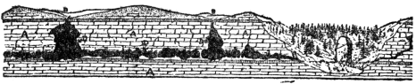
Fig. 23.—Structure section and part of landscape in a limestone region showing how caves and natural bridges are formed by the dissolving action of underground water. AA, limestone; BB, sink holes; DD, caves and galleries; and an arch (natural bridge) which is the remnant of a large cave. (After Shaler, U. S. Geological Survey.)
One interesting effect of the dissolving power of underground water in limestone regions is the development of caves or caverns. Most remarkable of all is Mammoth Cave, Kentucky, with its hundreds of miles of passageways and galleries. This marvelous work of nature is all a result of the action of underground water which has dissolved and carried away vast quantities of limestone. Echo River, which flows through the cavern, is still carrying on the work aided by various underground tributaries. The stalactites and stalagmites, which are so strikingly displayed in many caves, as at Luray, Virginia, in which water with carbonate of lime drips or oozes from the roof and, due mainly to evaporation, deposits the lime. Many wonderful and fantastic effects are thus produced. Where part of the roof of a cave is dissolved out, or falls in, a “sink hole” results. Where all but a portion of the roof of a cave or underground channel has fallen in, a natural bridge, like the famous one in Virginia, results, though natural bridges are also formed by other means.
In concluding this chapter we shall briefly discuss hot underground waters, hot springs, and geysers. There are two well-known ways by which underground waters may become heated. One is by the movement of water downward into the normally heated portion of the earth, the rate of increase downward being, as above stated, 1 degree F. for about 50 to 60 feet. Water descending two miles would, therefore, attain a temperature of about 200 degrees F. In some regions such a temperature may be reached at depths considerably less. Such water (under pressure) taking a short course to the surface (forming springs) at a lower level would retain much of its heat taken up far below the surface. In regions where there are great down-folds of the strata (i.e., synclines), as in the central to southern Appalachians, conditions appear to be favorable for such warm or hot springs, as, for example, at Hot Springs, Virginia. A second cause of the heating of underground water is by the descent of surface waters into contact with masses of still hot igneous rock of relatively recent geologic age. In some such cases the water does not go more than some hundreds of feet down and when, under proper conditions, it returns to the surface hot and even boiling springs may result.