Front matter (continued 4)
Reading edition
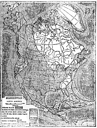
Fig. 38.—Map showing the general relations of land and water in North America during middle Mississippian time. (After Willis, courtesy of the Journal of Geology.)
Soon after mid-Silurian time the seas became greatly restricted almost to disappearance as such. In the eastern United States and southeastern Canada strata of that particular age are found only in parts of Ontario, New York, Ohio, Michigan, and from Pennsylvania southward to West Virginia, where they are characterized by red shales and sandstones, and salt and gypsum deposits. Such materials containing few fossils very clearly indicate deposition in either extensive lagoons or more or less cut-off arms of the sea under arid climate conditions rather than in ordinary marine water.
Still later in the Silurian the interior seas were partially restored, as shown by the fact that true marine strata corresponding to that age not only cover the salt and gypsum deposits, but are notably more extensive than they. About the close of the Silurian period almost all of the continent was dry land.
Unlike the Ordovician period, the Silurian closed without any mountain-making disturbance or great uplift of land. The Silurian period, like the preceding Ordovician and Cambrian, seems to have been free from any more than slight igneous activity as, for example, in Maine and New Brunswick. The total thickness of Silurian strata in North America is seldom more than a few thousand feet.
The salient features of the physical history of the next, or Devonian period, are much like those of the preceding Silurian. At the beginning of the Devonian almost all of the continent was dry land, but soon a long, narrow arm of the sea extended across the eastern side of the continent from the Gulf of St. Lawrence southward through western New England, southeastern New York and throughout the Appalachian district, thus reminding us of the long, narrow sound which occupied almost exactly the same territory during the early part of the Cambrian period. In the west the only water was a small embayment reaching across southern California into Nevada. By middle Devonian time these water areas had considerably expanded. During relatively late Devonian time the sea was so expanded as to cover much of the Mississippi Valley area, the Appalachian Mountains and St. Lawrence Valley areas, and most of the site of the Rocky Mountains, except for an island of considerable size reaching from New Mexico through Wyoming. The main lands were most of northeastern North America, a large land area extending from Florida to Nova Scotia, and a large area on the western side of the continent from California to Alaska.
A remarkable formation of late Devonian Age should be briefly described. In southeastern New York and the northern Appalachian region there was a tremendous accumulation of sediments which have consolidated into sandstone, together with some shale and conglomerate. This so-called “Catskill” formation is from 1,500 to 8,000 feet thick and is well shown as the main body of rock in the Catskill Mountains. It is largely a shallow-water deposit of essentially nonmarine origin, as proved by coarseness of material, ripple marks, and nonmarine fossils. All evidence points to the origin of this remarkable formation as a great delta deposit built out into the shallow interior sea. Notable thinning toward the west, with increasing fineness of grain of material, shows that the sediment came from the east, no doubt carried by a large river from the small continental land mass (called “Appalachia”) on the eastern side of North America.
The maximum thickness of the North American Devonian seems to be about 15,000 feet in the northern Appalachian region, but elsewhere it generally ranges from 1,000 to 4,000 feet thick. In North America the subdivisions of the Devonian strata of New York are taken as a standard for comparison, both because of the wonderful completeness and almost undisturbed character of the rocks there, and because they have been so carefully studied. The Devonian system is there fully 4,000 feet thick, with scarcely a minor subdivision missing, and it covers a wide area (one-third of the State) with many excellent outcrops. There was practically uninterrupted deposition of Devonian strata in southern New York. It is doubtful if there is greater refinement of knowledge regarding the Devonian or any other Paleozoic system of strata anywhere else in North America.
During middle to late Devonian time the region from southern New England to Nova Scotia and the St. Lawrence Valley was notably disturbed by earth movements, the lands having been considerably elevated and the rocks more or less folded. The great delta deposit of late Devonian time, already described as being thousands of feet thick in New York and Pennsylvania, was formed by one or more streams which carved much sediment from the newly upraised lands. Accompanying the uplift and folding of the rocks considerable masses of molten granite were forced into the earth’s crust and some molten rock was forced to the surface, producing volcanoes. Much of the granite may now be seen at the surface in various portions of the region, while deeply eroded volcanoes occur near the city of Montreal.
Except for the disturbance of the region from New England to the St. Lawrence, the Devonian period seems to have closed rather quietly, with fairly widespread sea water over the land as already outlined. This is proved by the fact that the early strata of the next period mostly rest in regular order upon the undisturbed late Devonian strata.
For many years the term “Carboniferous” period was used to designate a single period of geologic time which, in America at least, is now divided into two periods—the Mississippian and Pennsylvanian—corresponding, respectively, to the earliest and latest Carboniferous. In regard to the relations of land and water during the Mississippian period, the general statement may be made that the sea, already fairly extensive in the late Devonian, continued to spread until during the second half of the Mississippian, when most of the United States west of the eastern border of the Appalachians (except the Pacific Northwest), and also the Rocky Mountain region through Canada, were submerged.
A significant physical change marked the close of the Mississippian. This was the withdrawal of sea water from nearly all of the continent, the emergence of the land having been generally sufficient to allow considerable erosion. The fact that the Mississippian and the next, or Pennsylvanian, strata are separated by the most extensive distinct erosion surface in the whole Paleozoic group of rocks is the chief reason for considering those two sets of strata to have formed during separate periods of geologic time.
In eastern North America the Mississippian strata vary in thickness from a few hundred feet to a maximum of about 5,000 feet in eastern Pennsylvania. In the West, where the thickness is commonly several thousand feet, limestone greatly predominates. There appears to have been vigorous volcanic activity during the period from northern California to Alaska.
Certain profound crustal disturbances marked the close of the period in western Europe, resulting in upturning and folding of rocks during the process of mountain forming from Ireland to Germany, and from Bohemia to southern France. Abundant intrusions and extrusions of molten rocks accompanied the disturbances.
We turn next to a consideration of the Pennsylvanian period, which is of very special interest, because within the rocks of that age in North America, Europe, and China occur the greatest known coal deposits. The period opened with almost all of North America dry land undergoing more or less erosion. Early in Pennsylvanian time marine water began to overspread the western side of the continent, especially most of the western two-thirds of the area of the United States, where strata thousands of feet thick piled up. The sea was most widespread before the middle of the period, when the relations of land and water were about as shown by Figure 39.
Over the site of the Appalachians and most of the eastern half of the Mississippi Valley area the land either stood near sea level and was often swampy or marshy, or at other times it was a little below sea level, allowing tidewater to overspread the area. Such conditions alternated repeatedly, usually more or less locally, over different parts of the districts in which the great coal mines of the east are located. Under such conditions strata from 1,000 to 8,000 feet thick accumulated. Remarkable physical geography of this kind resulted in the growth and accumulation of vast quantities of vegetable matter which has changed into the world’s greatest coal beds. Similar conditions prevailed over parts of Nova Scotia, New Brunswick, and Rhode Island, where strata fully 13,000 feet thick accumulated.
“Perhaps the most perfect resemblance to coal-forming condition is that now found on such coastal plains as that of southern Florida and the Dismal Swamps of Virginia and North Carolina. Both of these areas are very level, though with slight depressions in which there is either standing water or swamp condition. In both regions there is such general interference with free drainage that there are extensive areas of swamp, and in both there are beds of vegetable accumulations. In each of these areas there is a general absence of sediment and therefore a marked variety of vegetable deposit. If either of these areas were submerged beneath the sea, the vegetable remains would be buried and a further step made toward the formation of a coal bed. Reelevation, making a coastal plain, would permit the accumulation of another coal bed above the first, and this process might be continued again and again.” (H. Ries.) But it is not necessary to assume repeated oscillations of a swamp area up and down as the only way of accounting for a succession of coal beds one above another in a given region, because a general, but intermittent, subsidence, with possibly some upward movements, would occasionally cause the prolific plant life of a swamp to be killed, after which sediment would deposit over the site. Shoaling of water by accumulation of sediment would permit the development of more swamp plant life.
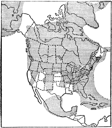
Fig. 39.—Map showing the general relations of land and water, including the great coal-plant swamp areas (vertical lines), in North America during the Pennsylvanian period at least 10,000,000 years ago. Lined areas represent land. (After Willis, courtesy of the Journal of Geology.)
In most coal-mining districts there are at least several coal beds, one above another. In Illinois there are nine; in Pennsylvania at least twenty; in Alabama, thirty-five; and in Nova Scotia seventy-six, but not all are important commercially. Each coal bed in such a region represents a swamp which existed in Pennsylvanian time at least ten or twelve million years ago, and in which there grew a luxuriant vegetation. Many individual swamps of that time were of wide extent. The famous Pittsburgh bituminous coal bed represents probably the largest one of all. It extends from western Pennsylvania into parts of Ohio and West Virginia over an area of fully 15,000 square miles. More than 6,000 square miles of it are being worked and the coal bed averages seven feet in thickness over an area of 2,000 square miles. Among the various anthracite coal beds of the same age in eastern Pennsylvania the Mammoth bed is exceptionally thick, reaching a maximum of fifty feet or more.
In order that the reader may not gain the impression that coal beds make up a very considerable bulk of the strata in coal-mining regions, we should state that, on the average, coal actually constitutes less than 2 per cent of the containing strata.
Some idea of the tremendous length of the geologic ages may be gained by a consideration of the time which must reasonably be allowed for the accumulation of so many coal beds and their containing strata. It has been estimated that a luxuriant growth of vegetation would produce 100 tons of dried organic matter per hundred years. Compressed to the specific gravity of coal (1.4) this would form a layer less than two-thirds of an inch deep on an acre. During the chemical alteration of vegetable matter to coal about four-fifths of the organic matter disappears in the form of gases. On this basis, then, it would take about 10,000 years to accumulate the vegetable matter represented in a coal bed one foot thick. When we realize that the total thickness of the coal beds of the Pennsylvanian system of strata in the great mining regions is commonly from 100 to 250 feet, we conclude that the time they represent is from 1,000,000 to 2,500,000 years. It seems most reasonable that the time necessary for the deposition of the containing strata must have been at least as long. It is, therefore, a fair conclusion that the Pennsylvanian period lasted from 2,000,000 to 5,000,000 years.
That the climate of the great Coal Age was warm (not tropical), very moist, and uniform, is borne out by such facts as the following, according to D. White: The succulent nature of the plants with their spongy leaves indicates prolific growth in moist, mild climate; lack of yearly rings of growth points to lack of distinct seasons; as in the case of many existing plants the aerial roots signify a warm, moist climate; plants of to-day nearest like the coal plants thrive best in warm, moist regions; vegetable matter at present accumulates best in temperate rather than tropical climates, because there decay is not so rapid; and the remarkable uniformity of climate over the earth is clearly indicated by finding fossil plants of almost or exactly identical types in rocks of Pennsylvanian Age from the Polar regions to the Tropics. The more remarkable plants of the great Coal Age time are described in the chapter on the evolution of plants (Plate 15).
During the last (Permian) period of the Paleozoic era the marine waters of the west, and the alternating shallow tidewater, swamps, and near sea level lands of the east gradually gave way to dry lands, so that by the close of the period marine water covered only a small part of the Southwest from Oklahoma across central Texas to southern California and northwestern Mexico, where strata as much as several thousand feet thick formed. In the middle western part of the area of the United States, especially from northern Texas to Nebraska and Wyoming, the climate was arid and red strata (so-called “Red Beds”), salt, and gypsum were extensively deposited on land and in great salt lakes or more or less cut-off arms of the sea. Strata commonly from 2,000 to 7,000 feet thick were there deposited. Similar conditions prevailed in parts of Nova Scotia, New Brunswick, and Newfoundland, where strata 8,000 feet thick accumulated. Over the site of most of the Appalachians the coal swamp conditions, with local sea incursions, continued from the preceding period, as shown by the character of the strata (1,000 feet thick) containing some coal.
Vigorous volcanic activity which, as already mentioned, began in the Mississippian period from northern California to Alaska continued not only through the Pennsylvanian and Permian but also into the early Mesozoic era, as shown by the great quantities of volcanic materials associated with rocks of those ages.
The Permian presents a puzzling combination of climatic conditions which causes it to stand out in marked contrast against the generally mild and uniform climates of nearly all of preceding Paleozoic time. Most remarkable of all are the records of a great Ice Age during early Permian time. One surprising fact is the widespread distribution of the glacial deposits in both the north and south temperate zones, and even well within the torrid zone. They are perhaps most extensive and best known in Australia, South Africa, India, and Brazil. Glacial deposits almost certainly of the same age on smaller scales occur in eastern Massachusetts, southern England, eastern Russia and the Caucasus region. Although the areas occupied by the Permian glaciers, which in many cases must have been extensive ice sheets, cannot be accurately delimited, it is, nevertheless, quite certain that the ice was notably more extensively developed than it was during the great “Ice Age” of late (Quaternary) geologic time. Another surprising fact is that certain of the glaciers must have come down to, or nearly to, sea level, as shown by the direct association of marine strata with glacial deposits. Thus, in southern Australia at least eight beds of glacial materials (some of them 100 to 200 feet thick) occur within true marine strata 2,000 feet thick. A third remarkable fact is that the Permian Ice Age, like the Quaternary Ice Age, had interglacial epochs of relatively mild climate, as proved by the occurrences of beds of coal between certain of the layers of glacial materials in Australia, South Africa, and Brazil.
During much of Permian time the climate was arid over large areas as, for example, much of the western interior of the United States, from Ireland to central Germany, and in eastern Russia, as proved by great deposits of salt, gypsum, and red sediments. During late Permian time the greatest salt beds in the world were deposited in northern Germany, a well near Berlin having penetrated a practically solid body of salt associated with certain potash and magnesia salts to a depth of about 4,000 feet without reaching the bottom.
The occurrence of some coal beds, especially in the earlier Permian rocks shows that, temporarily at least, climatic conditions must have favored luxurious growths of coal-forming plants in South Africa, Brazil, Australia, and our own Appalachian district.
From the above facts we see that the Permian represents a remarkable combination of very extensive glaciation, widespread aridity, and warmth and moisture favorable to prolific plant growth all in a single period of geologic time.
The Permian period, and, therefore, the great Paleozoic era, was brought to a close by one of the most profound physical disturbances in the known history of North America. This has been called the Appalachian Revolution because at that time the Appalachian Mountain range was born out of the sea by folding and upheaval of the strata. In fact, “the Appalachian Revolution was one of the most critical periods in the history of the earth, and may have been the greatest of them all in its results.” (C. Schuchert). Mountains were brought forth in all the continents, including Australia. All of the mountains which were formed late in the Paleozoic have since been profoundly affected by erosion, and the only ones (e.g., Appalachians) which now show considerable altitudes are those which have been rejuvenated by relatively (geologically) recent earth movements.
We shall now turn our attention to the origin of the Appalachian Range. All through the vast time (probably fully 20,000,000 years) of the Paleozoic era a large land mass was remarkably persistent along the eastern side of North America. This land, which has been called “Appalachia,” had its western boundary approximately along the eastern border of the sites of the Appalachian Range and the western part of New England. It extended east of the present coast line at least to the border of the continental shelf from 100 to 200 miles out. Concerning the actual altitude and topography of Appalachia we know little or nothing, but the tremendous quantities of sediment derived from its erosion show that it was high enough during nearly all of its history to undergo vigorous erosion.
Barring certain minor oscillations of level, the region just west of Appalachia was mostly occupied by sea water throughout much of Paleozoic time, and sediments derived from the erosion of Appalachia were laid down layer upon layer as strata upon that sea bottom. In general, the coarsest and greatest thickness of sediments accumulated relatively near the land, while finer materials, in thinner sheets, deposited well out over much of the eastern Mississippi Valley area in the shallow seas which were there so commonly present. By actual measurement we know that the thickness of strata deposited over the site of the Appalachians was at least 25,000 feet. Since these latter strata are mostly of comparatively shallow sea-water origin, as proved by coarseness of grain of material, ripple marks, fossil coral reefs, etc., we are forced to conclude that this marginal sea bottom gradually sank while the process of sedimentation was in progress. Otherwise we cannot possibly explain the great pile of strata of shallow water origin. The very weight of accumulating strata may either have aided or actually caused the sinking of the long, relatively narrow trough.
Finally, toward the close of the Paleozoic era, sinking of the marginal sea floor and deposition of sediments gave way to a yielding of the earth’s crust by a great force of lateral compression, causing the strata to be thrown into folds well below the surface and more or less fractured in their upper portion. Thus, along the eastern side of the site of the great interior Paleozoic sea, the Appalachian Mountains rose out of what for millions of years had been a long, narrow, sinking sea floor. There was more or less folding from the Gulf of St. Lawrence to central Alabama. Figure 24 diagrammatically represents the principal stages in the history of the Appalachian Range.
While the most pronounced earth disturbance occurred through the long Appalachian belt, the whole eastern side of the continent was profoundly affected. Thus the Mississippi Valley area east of the Great Plains was considerably upraised never again to be submerged except along the Gulf Coast, and an eastern interior sea has never since overspread the region which was repeatedly sea-covered during Paleozoic time.
CHAPTER XV
MEDIEVAL EARTH HISTORY
(Mesozoic Era)
W
WHAT was the condition of North America during the first or Triassic period of the Mesozoic era, approximately 8 or 10 million years ago? As a result of the Appalachian Revolution the sea was excluded from all the land except along much of the western side from southern California to parts of Alaska. On this western side of the continent the Appalachian Revolution had little or no effect and the Permian conditions continued, essentially without change through the Triassic. The Triassic strata up to 4,000 feet thick are there of typical marine origin. In British Columbia and Alaska there was much igneous activity.
Throughout much of the Rocky Mountains and Great Plains region of the western United States there are extensive deposits of red sediments (so-called “Red Beds”), containing layers of salt and gypsum, from 200 to 1,000 or more feet thick. These strata commonly rest in regular order on Permian Red Beds, so that conditions of deposition of Permian time continued through Triassic time, that is continental deposits formed mostly in salt lakes, fresh lakes, along stream courses, and on land in part by the action of wind.
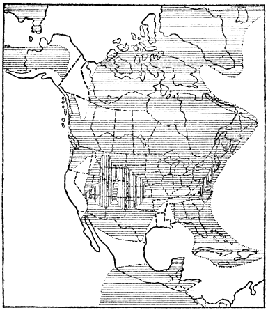
Fig. 40.—Map showing the general relations of land and water in North America during the Triassic period. Lined areas represent land; vertical-lined areas, basins in which continental deposits formed. (Based upon map by Willis; courtesy of the Journal of Geology.)
In the eastern half of North America there is no record of accumulation of any marine strata whatever, because, as a result of the Appalachian Revolution, the land was brought well above sea level. There was, however, deposition of a remarkable series of nonmarine strata in several long, narrow, troughlike depressions whose trend was parallel to, and just east of, the main axis of the newly formed Appalachian Range. These troughs lay between the Appalachians and the very persistent old land mass called Appalachia which we have already described. The facts that these troughs are truly down-warps; that they so perfectly follow the trend of the Appalachian Mountain folds; and that the strata in them are of late Triassic Age, make it certain that they were formed by a great lateral pressure which must have been a continuation of the Appalachian Revolution. Thus the Appalachian Mountains continued to grow well into the Triassic period, and, while the Paleozoic strata were being folded, the surface of old Appalachia (including part of the Taconic Mountain region) was down-warped to form the troughs in which the late Triassic strata accumulated. One trough extended through the Connecticut Valley; another (the largest) from southeastern New York through northern New Jersey, southeastern Pennsylvania, Maryland, and into Virginia; while several smaller ones occurred in Virginia and North Carolina.
The down-warps or troughlike basins were very favorably situated for rapid accumulation of thick sedimentary deposits because of their position just between large, high land masses which were being vigorously eroded. The sediments derived from the erosion of the young Appalachians were especially abundant because of the vigorous wearing down of the newly formed high mountains. A thickness of from 5,000 to fully 15,000 feet of mostly red sandstones and shales accumulated in these down-warps, the character and great thickness of the strata strongly pointing to gradual down-warping as the deposition of the sediments went on. It is often stated that these strata were formed in estuaries, but, in the northern areas, at least from Massachusetts to Maryland, many of the layers show ripple marks, sun cracks, rain-drop pits, fossil plants, and fossil bones and tracks of land reptiles. Such strata may well have formed in very shallow water, such as river-flood plains or temporary lakes, where changing conditions frequently allowed the surface layers to lie exposed to the sun.
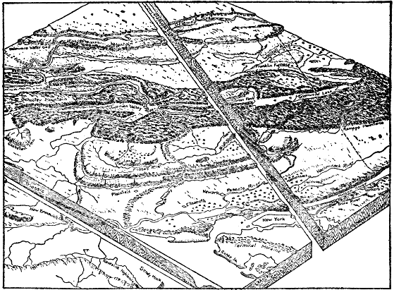
Fig. 41.—Block diagram of the region westward from New York City and vicinity, showing the main relief features, the underground relations of rocks of widely different ages, and the relation of the relief to the rock formations. (Part of larger drawing by A. K. Lobeck.)
During the time of the accumulation of the late Triassic strata in the down-warp basins there was considerable igneous activity, as proved by the occurrence of sheets of igneous rock within the body of strata. In some cases true lava flows with cindery tops were forced out on the surface and then buried under later sediments, while in other cases the sheets of molten rock were forced up either between the strata or obliquely through them, thus proving their intrusive character. As a result of subsequent erosion, these very resistant lava masses often stand out conspicuously as relief features. Perhaps the most noteworthy example is the great layer of such intrusive igneous rock, part of which outcrops for seventy miles mostly as a bold cliff forming the famous Palisades of the Hudson, near New York City. During the process of cooling and solidification of the molten mass there was contraction which expressed itself by breaking the rock mass into great, crude, nearly vertical columns, and hence the origin of the name “Palisades.” The cliff character of the outcrop is due to the fact that the lava is much more resistant to erosion than the sandstone above and below it. In the Connecticut Valley of Massachusetts a layer of lava several hundred feet thick boldly outcrops, forming the crest of the well-known Mount Tom-Mount Holyoke Range.
The close of the Triassic period was marked by enough uplift to leave the whole eastern two-thirds of the continent dry land undergoing erosion. The Triassic deposits of the Atlantic Coast are much broken up into large fault blocks, and this faulting probably took place as a result of the crustal disturbances toward the end of the period. In the west the Triassic conditions seem to have continued without much change into the next (or Jurassic) period.
During the Jurassic period the relations of land and water in North America were very simple. In the earlier Jurassic all was dry land except portions of the western fringe of the continent from southern California to Alaska, where marine strata 2,000 to 10,000 feet thick accumulated. Late in the period the conditions were the same, except for a long, narrow arm of the sea or mediterranean which extended from the Arctic Ocean southward across the site of the Rocky Mountains to Arizona. There is no evidence for the existence of anything like real mountains anywhere on the continent during the period.

Fig. 42.—Structure section showing profile and underground relations of rocks across the Connecticut Valley (through Mount Tom) of Massachusetts. Js and Jl are sandstone strata, with included lava sheets (in black) resting upon Paleozoic rocks on either side. The rocks have been notably tilted and faulted. (After Emerson, U. S. Geological Survey.)
Profound crustal disturbances marked the close of the Jurassic period in the western part of the continent. Strata which had accumulated to great thickness during millions of years of time, mainly over the sites of the Sierra Nevada and Cascade Mountains, finally yielded to a tremendous force of lateral compression, especially in the Sierra region, and were folded, crumpled, and upraised. Thus the Sierra-Cascade district was originally built up into a high mountain range. Since that time the Sierras have been much cut down by erosion and they have been rejuvenated by faulting and tilting of the great earth block. The Cascade Range from northern California into British Columbia was apparently not so profoundly raised, and its present height is mainly due to subsequent volcanic activity. The rocks of the Klamath Mountains of northwestern California, and of the Humboldt Range of Nevada, were also folded at that time.
During the mountain-making disturbances on the western side of the continent great quantities of molten granite were forced up into the lower portions of the folding strata. Because of profound subsequent erosion this granite is now widely exposed as, for example, in the great walls of the Yosemite Valley.
During the earlier half of the last period (the Cretaceous) of the Mesozoic era, sea water spread from Mississippi northwestward to the site of Denver and southward over Texas and much of Mexico. At the same time much of the western margin of the continent from Alaska to California was submerged. All the rest of the continent was land. During this time sediments accumulated on low lands just east of the site of the present Rocky Mountains, and also east of the Appalachians, as proved by the numerous fossils of land plants found in these deposits.
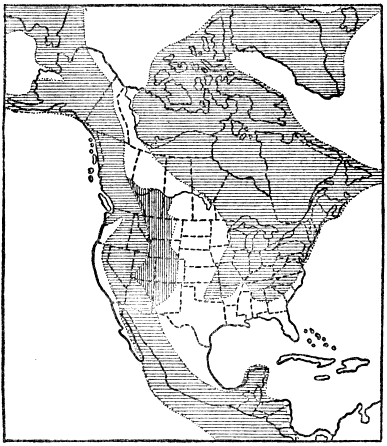
Fig. 43.—Map Showing the general rotations of land and water in North America during later Cretaceous time, several million years ago. Lined areas represent land; vertical lines, mainly continental deposits. (Principal data from a map by Willis, published in the Journal of Geology.)
As Cretaceous time went on the marine waters gradually spread until the whole Atlantic and Gulf coastal plain regions from Long Island, New York, to Mexico became submerged under marine water, and a wide arm of the sea, or great mediterranean, spread from Texas north to the mouth of the Mackenzie River. The Gulf of Mexico was thus directly connected with the Arctic Ocean. This great interior sea was nowhere connected with the Pacific Ocean, though portions of the Pacific border of the continent were submerged. This vast interior sea was not only the largest of any which reached well into the continent since the Mississippian period of the Paleozoic era, but it was the last body of marine water which ever extended well into the continent. It should be stated that the later Cretaceous was also a time of unusually widespread submergence of the continents, when most of southern Europe and southeastern Asia, as well as about one-half of both Africa and South America were submerged. Over much of the site of the Rocky Mountains during the late Cretaceous there were low lands receiving continental deposits, and extensive marshes supporting prolific vegetation were common. Much of this vegetable matter became buried, and has since been converted into workable coal.
The maximum thickness of strata accumulated during all of Cretaceous time over the Atlantic coastal plain area was about 1,700 feet; over the Gulf coastal plain region fully 7,500 feet; over the western interior 10,000 to 15,000; and over parts of the Pacific border 25,000 to 30,000 feet, as in California. The last-named figures are truly phenomenal, representing a thickness about equal to the total thickness of all the strata accumulated during the whole Paleozoic era (seven periods) and piled up in the Appalachian Mountain region. This great deposit of strata of mostly early Cretaceous Age is readily accounted for when we realize that these sediments, which accumulated in the marginal sea bottom, were derived from the very rapidly eroding, newly formed lofty Sierra Nevada Range.
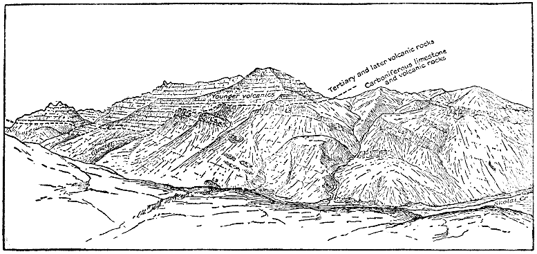
Fig. 44.—Sketch of a mountain range along Skolat Creek, Alaska, showing Tertiary lava beds resting upon deeply eroded tilted limestones and lavas of late Paleozoic (Carboniferous) Age. The present topography has been produced by erosion since the Tertiary lavas flowed out. (After U. S. Geological Survey.)
Especially in Alabama and Texas the Cretaceous system is remarkable for its richness in chalk deposits. In Alabama a widespread formation of late Cretaceous Age, about 1,000 feet thick, contains much nearly pure white chalk, and in Texas a similarly constituted formation of early middle Cretaceous Age is from 1,000 to 5,000 feet thick. These chalk deposits consist almost wholly of carbonate of lime shells or very tiny single-celled animals which accumulated under exceptionally clear sea water which spread over those parts of Alabama and Texas where the chalk now occurs. Here again we have a bit of evidence supporting the fact of very long geologic time. Think of how long it must have taken for the tiny (even microscopic) shells to form a widespread layer of chalk nearly a mile thick!
The close of the Cretaceous period, or what is the same, the close of the Mesozoic era, was marked by some of the grandest crustal disturbances in the known history of the earth. In fact, it is not known that the western hemisphere was ever affected by more profound and widespread mountain-making disturbances than those which took place toward the close of the Mesozoic era, and continued into the succeeding Tertiary period. These disturbances were of three kinds: folding of strata, volcanic activity, and renewed uplift of old mountains without folding of the rocks. Greatest of all was the “Rocky Mountain Revolution,” during which the thick strata, which accumulated during the Paleozoic and Mesozoic eras over the site of the Rockies, yielded to vigorous deformation when they were more or less folded and dislocated from Alaska to Central America. This was in truth the birth of the Rocky Mountains, although their existing altitude and configuration have, to a very considerable degree, resulted from later uplift and erosion. In the northern United States and southern Canada the Rocky Mountain strata, up to over 40,000 feet thick, were most severely folded and fractured, forming a range which quite certainly was fully 20,000 feet high. In this district a great thrust fault, hundreds of miles long, developed, and rocks as old as the Proterozoic were shoved at least seven miles, and probably as much as twenty miles, westward, over Cretaceous and other rocks much later than the Proterozoic. At the same time the Andes Mountains throughout South America were notably upraised and the rocks folded.
The second type of physical disturbance was volcanic activity which took place on a tremendous scale, and which appears to have started as a direct accompaniment of the Rocky Mountain Revolution. This igneous activity took place not only in the Rocky Mountains but also westward to and in the Sierra-Cascade Range, as well as in the mountains of western British Columbia and Alaska. This activity continued well into the succeeding Cenozoic era, and it is more fully considered in the next chapter.
The third type of crustal disturbance took place on a large scale when the Appalachian Mountains, which had been almost wholly planed away by erosion during Mesozoic time, were reelevated from 1,000 to 3,000 feet by an uplifting force not accompanied by folding. All or nearly all of New York and New England, as well as much of southeastern Canada, were similarly upraised at the same time. This notable uplift of so much of eastern North America is a matter of great importance because the major relief features of that area have been produced by erosion or dissection of the upraised surface since late Mesozoic or early Cenozoic time. In view of the fact that this work of erosion took place almost wholly during the Cenozoic era, it will be discussed in the next chapter.
In conclusion, brief mention may be made of the kind of climate of the Mesozoic era. As shown by the character and distribution of fossil plants and animals, the Mesozoic climate was in general mild and rather uniform over the earth, but with some distinction of climatic zones. Such distinction of climatic zones is unknown for the Paleozoic era, while it was notably less than at present.
CHAPTER XVI
MODERN EARTH HISTORY
(Cenozoic Era)
S
SINCE the Cenozoic era is the last one of geologic time, it will be of particular interest to trace out the main events which have led up to the present day conditions, especially in North America. Both because of the recency of the time and the unusual accessibility of the rocks, which are mostly at or near the surface, our knowledge of the Cenozoic era is exceptionally detailed and accurate. It will, therefore, be more necessary than ever to select only the very significant features of this history for our brief discussion.
During the first half of the Tertiary period portions only of the Atlantic coastal plain were submerged under shallow water, but soon after the middle of the period (Miocene epoch) the sea spread over practically the whole Atlantic coastal plain area from Martha’s Vineyard south to and including Florida. During the late Tertiary the marine waters had become greatly restricted, and by the close of the period the sea was entirely excluded from the Atlantic seaboard. The total thickness of these Tertiary strata is less than 1,000 feet, and they all tilt downward gently toward the sea. The strata consist mostly of unconsolidated sands, gravels, clays, marls, etc.
The Gulf coastal plain area from Florida through Texas and south through eastern Mexico was largely overspread by the sea during most of Tertiary time, except the latest. During early Tertiary time an arm of the Gulf reached north to the mouth of the Ohio River. Late in the period but little of the Gulf Plain was submerged, and at its close sea water was wholly excluded. On the Gulf Coast the Tertiary strata from 2,000 to 4,000 feet thick are also mainly sands, gravels, clays, and marls. They are commonly rich in fossils, and they show a gentle tilt downward toward the Gulf.
Throughout Tertiary time local portions of the Pacific border of the continent were submerged, this having been especially true of portions of California, Oregon, and Washington. In spite of the very restricted marine waters, the Tertiary strata of the Pacific Coast, especially in California, are remarkably thick, 10,000 to 20,000 feet being common, while the maximum thickness is fully 30,000 feet. Such great thicknesses are readily explained when we realize that erosion was notably speeded up by pronounced uplifts resulting from crustal disturbances toward the close of the preceding period, and again in the midst of the Tertiary period itself.
To summarize the Tertiary relations of sea and land for North America we may say that only local portions of the continental border ever became submerged, and that, by late Tertiary time, practically the whole continent was a land area. At the close of the period the continent was, as we shall see, even larger than now because the continental shelves of the ocean were then also largely above water.
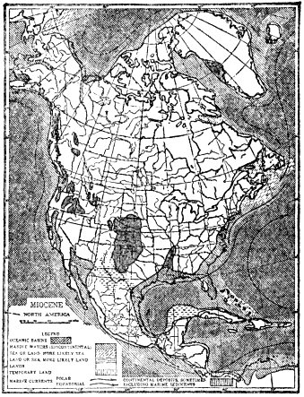
Fig. 45.—Map showing the general relations of land and water in North America during part of the middle Tertiary period. (After Willis, courtesy of the Journal of Geology.)
The whole of the Cenozoic era, including both the Tertiary and Quaternary periods, has been a time of profound crustal disturbances throughout much of the continent, certain of these movements having continued right up to the present time, with positive evidence that some of them are still continuing. These great movements have included notable foldings of strata, uplifts without folding, faulting, and igneous activity, the whole effect having been to greatly increase the general altitude and ruggedness of the continent. In fact, North America is not known ever to have been at once higher, broader, and more rugged than it was very late in the Tertiary, or early in the Quaternary, period. Since that time the only notable change (barring the great Ice Age and its effects) has been a restriction of the area of the continent to its present size by spreading of sea waters over the borders of the continent, that is over the continental shelves.
We shall now rather systematically consider the more profound earth changes which have affected the continent, producing the existing major relief features, from west to east.
The “Coast Range Revolution” took place in the midst of the Tertiary period. Over the site of the Coast Ranges, strata had accumulated, especially during Cretaceous and earlier Tertiary times, to a thickness of thousands of feet. In middle Tertiary time these strata were subjected to a mountain-making force of compression and more or less folded, faulted (fractured), and uplifted into the Coast Range Mountains. Some portions of the range were intensely folded and faulted and upraised many thousands of feet, while other portions were only moderately folded and uplifted. It is an interesting fact that the great San Francisco earthquake rift or fault originated at this time. It was a renewed, sudden movement of a few feet along this fault which caused the disastrous earthquake of 1906. Still other considerable earth movements took place in the Coast Range region during late Tertiary and Quaternary times, as, for example, uplift without folding, as proved by distinct sea-cut terraces at altitudes of more than a thousand feet, like those north of San Francisco and south of Los Angeles. A moderate amount of still later subsidence has caused the development of San Francisco Bay. The large islands off the coast of southern California have in very recent geologic time (probably Quaternary) been cut off from the mainland by sinking of the land.
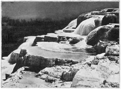
Plate 11.—(a) Part of the Mammoth Hot Springs Terrace in the Yellowstone Park. The view shows the deposit with boiling water flowing over it. The water enters the earth back on the mountain, travels underground in contact with hot lava, rises through limestone, from which the boiling water takes into solution much carbonate of lime which is deposited when the water reaches the surface. (Photo by Jackson, U. S. Geological Survey.)
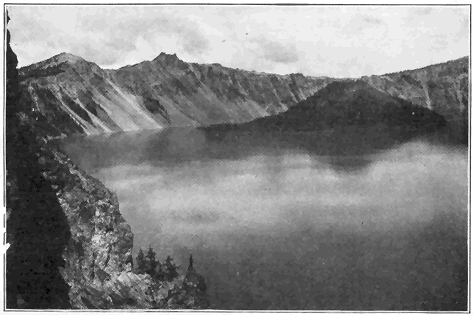
Plate 11.—(b) View Across Part of Crater Lake, Oregon. This great hole, 3,000 to 4,000 feet deep and 6 miles in diameter and now partly filled with a lake 2,000 feet deep, was formed by a subsidence of the top of a once great cone-shaped volcano fully 14,000 feet high above the sea. The high rock in the distance rises 2,000 feet above the lake which is over 6,000 feet above sea level. The island is a small volcano of recent origin. (Photo by Russell, U. S. Geological Survey.)
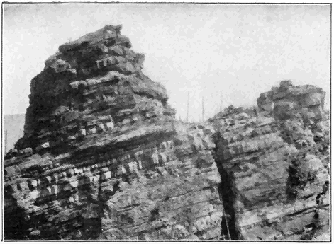
Plate 12.—(a) Detailed View of Part of the Very Oldest Known (Archeozoic) Rock Formation of the Earth. The rock is distinctly stratified and represents sands and muds deposited layer upon layer upon a sea floor at least 50,000,000 years ago. The sands and muds first consolidated into sandstone and shale below the earth’s surface. Then, under conditions of heat, moisture, and pressure, they were notably altered, mainly by crystallization of minerals, and raised high above sea level. Finally the strata were laid bare by erosion. (Photo by the author.)
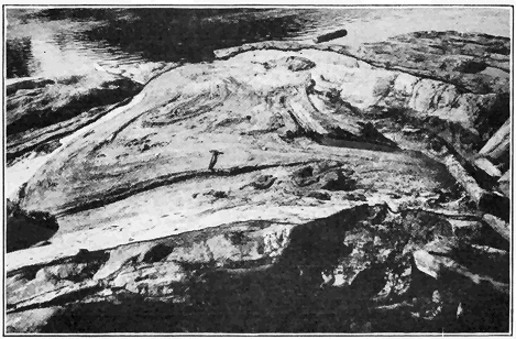
Plate 12.—(b) A Twisted Mass of Stratified Archeozoic Limestone Surrounded by Granite in Northern New York. The limestone was enveloped in the granite while it was being forced in molten condition into the earth’s crust. (Photo by the author.)
The Sierra Nevada Range, which originated by intense folding of rocks late in the Jurassic period, underwent profound erosion until about the middle of the Tertiary period, by which time it had been cut down to a range of hills or low mountains. Then the great fault (fracture) previously described began to develop along the eastern side. As a result of many sudden movements along this fault, which is hundreds of miles long, the vast earth block has been tilted westward with a very steep eastern face and a long, more gradual western slope, the crest of the fault block forming the summit of the range. The amount of nearly vertical displacement along this fault has been commonly from 10,000 to 20,000 feet, and, in spite of considerable erosion of the top of the fault block and accumulation of sediment at its eastern base, the modified fault face now usually stands out boldly from 2,000 to 10,000 feet high. As an evidence that this movement of faulting has not yet ceased we may cite the Inyo earthquake of 1872, when there was a sudden renewal of movement of ten to twenty-five feet along this fault for many miles. Since the great Sierra block began to tilt, the many mighty canyons, like Yosemite, Hetch-Hetchy, King’s River, and Feather River, have been carved out by the action of streams, in some cases aided by former glaciers. King’s River canyon has been sunk to a maximum depth of 6,900 feet in solid granite solely by the erosive action of the river!
The Cascade Mountains, too, were reduced to nearly a peneplain condition by late Tertiary time when they began to be rejuvenated by arching or bowing of the surface unaccompanied by great faulting or fracturing, and many canyons, like that of the Columbia River, have since been carved out.
Mention should now be made of the vigorous volcanic activity which took place in the Cascade and Sierra Nevada Ranges. Most of this activity occurred during Tertiary time (particularly in the latter part) and it has continued with diminishing force practically to the present time. In California streams of lava buried many gold-bearing river gravels which have yielded rich mines. Many well-known mountain peaks, such as Shasta, Lassen, Pitt, Hood, and Rainier, from northern California to Washington, are great volcanic cones which date from Tertiary time, and which are now mostly inactive. That this volcanic activity has not yet altogether ceased is shown by renewed eruptions of Mount Lassen (or Lassen Peak, altitude 10,437 feet) in northern California. Since the beginning of this renewed activity in 1914, several hundred outbursts have occurred. No molten rock has flowed out, but large quantities of rock fragments, dust and steam have been erupted, in many cases forming great clouds two or three miles high over the top of the mountain (Plate 10). At this writing (October, 1920), Mount Lassen is still showing vigorous activity. At Cinder Cone, only ten miles from Mount Lassen, there were two eruptions of cinders and a considerable outpouring of lava within the last 200 years. Still other very recent cinder cones occur in southeastern California and Arizona.
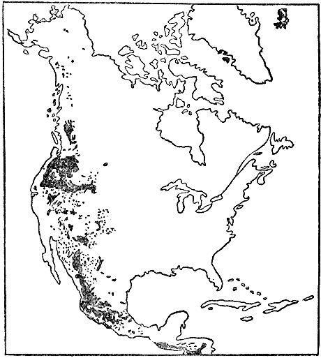
Fig. 46.—Sketch map showing the distribution of volcanic rocks of Cenozoic (mostly Tertiary) Age in western North America. Only one volcano (Mount Lassen, California) is now active in the United States proper, but a number are more or less active in Mexico and Central America. (Data from Willis, U. S. Geological Survey.)
One of the greatest lava fields in the world forms the Columbian Plateau between western Wyoming (including the Yellowstone National Park) and the Cascade Mountains from northeastern California to northern Washington. It covers fully 200,000 square miles and is really considerably larger than shown on the map because the lava in parts of the plateau region are covered by very recent sedimentary materials.
The great lava fields of the Deccan, India, and of the plateau region of western Mexico are comparable in size to the Columbian field and these lava fields are all of the same age. In the Columbian Plateau most of the lava was poured out during later Tertiary time. Sheets of molten rock, averaging fifty to one hundred feet in thickness, spread out over various parts of the region and piled up by overlapping layers one over another until the lava plateau more than a mile high was built up. Many hills and low mountains were completely buried under the molten floods, and in other places the liquid rock masses flowed against the higher mountains. “For thousands of square miles the surface is a lava plain which meets the boundary mountains as a lake or sea meets a rugged and deeply indented coast.... The plateau was long in building. Between the layers are found in places old soil beds and forest grounds and the sediments of lakes.... So ancient are the latest floods in the Columbia River Basin that they have weathered to a residual yellow clay from thirty to sixty feet in depth, and marvelously rich in the mineral substances on which plants feed. In the Snake River Valley the latest lavas are much younger (Quaternary). Their surfaces are so fresh and undecayed that here the effusive eruptions may have continued to within the period of human history.” (W. H. Norton.) Many of the lava layers are plainly visible where the Columbia River has cut its great gorge or canyon. The Snake River in places has sunk its channel several thousand feet into the lava plateau without reaching underlying rock.
Both north and south of the Columbian Plateau there was also much volcanic activity in the Rocky Mountain region during Tertiary time. A single formation in Colorado consists mostly of volcanic “ash” or dust over 2,000 feet thick. There was also much volcanic activity over the Colorado Plateau area of southern Utah, New Mexico, and Arizona. The volcanoes there exhibit all stages from those which are very recent and practically unaffected by erosion to others which have been completely cut away with the exception of the cores or “volcanic necks.”
During the second half of the Tertiary period the whole region known as the Great Basin, between the Sierra Nevada Mountains of California and the Wasatch Mountains of Utah, began to be affected by profound faulting or fracturing and tilting of portions of the earth’s crust. The two largest faults, one on the western side of the Wasatch Range and the other on the eastern side of the Sierra Range, are each hundreds of miles long. Each of these ranges owes most of its present altitude to the uptilting of great fault blocks, and most of the many nearly north-south Basin Ranges of Nevada and Utah are in reality recently tilted fault blocks.
Turning now to the Colorado Plateau, studies have shown that region to have been more or less periodically raised fully 20,000 feet since the beginning of Tertiary time, but because of profound erosion in the meantime its present altitude is only 6,000 to 9,000 feet. During late Tertiary time the land stood at a much lower level than to-day, so that, practically during the last period (Quaternary) of geologic time, the region has been elevated to its present position. As a direct result of this profound rejuvenation the Colorado River has had its erosive activity tremendously increased, and it has carved out the mightiest of all existing canyons—the Grand Canyon. The work of deepening and widening the canyon is still proceeding at a rapid geologic rate.
As we have learned, the Rocky Mountains and many of its subsidiary ranges were formed by folding and uplift of strata toward the close of the Mesozoic era (Cretaceous period). During much of Tertiary time the newly formed mountains had been considerably reduced by erosion. Then, late in the Tertiary period, much of the Rocky Mountain region, as well as much of the Great Plains area just east of the mountains, became rejuvenated by differential uplift without any notable folding of strata. We can tell that this general uplift amounted to at least several thousand feet because definite formations of relatively late Tertiary strata, originally horizontally deposited under inland bodies of water, gradually rise so that at the base of the Front Range of the Rockies they are fully 3,000 feet higher than they are 200 miles or more farther east. Thus, the original folding and faulting of the Rockies, Tertiary volcanic activity, late Tertiary rejuvenation, and subsequent erosion account for the present altitude and relief features of the great Rocky Mountain system.
Portions of the rejuvenated Great Plains region have been notably dissected by erosion since the late Tertiary, this being particularly true of the so-called “Bad Lands,” especially in parts of Wyoming and South Dakota, where mostly relatively soft Tertiary strata have been cut to pieces.
Turning our attention now to the eastern half of the continent we find that all, or nearly all, of it was more or less raised toward the close of the Tertiary period. Practically the whole Mississippi Valley east of the Great Plains, as well as much of the country to the north in Canada, was elevated some hundreds of feet and the streams have since the late Tertiary uplift (except where the land was ice-covered during the Ice Age) been at work sinking their channels below the newly upraised surface.
As already pointed out, the lowlands of the Atlantic and Gulf Coastal Plains were mostly submerged under the sea during early middle Tertiary time. By the close of the period they had emerged practically to their present positions, and they have been only moderately affected by erosion.
We have still to explain the existing topography or relief of a large and important part of eastern North America, including the whole of the Appalachian Mountains, Allegheny Plateau, Piedmont Plateau, New York, New England, and the Canadian region to the north. As a starting point in this discussion we should recall the fact that, after the great Appalachian Mountain Revolution toward the close of the Paleozoic era, the predominant geologic process which affected the region under consideration was erosion throughout the succeeding Mesozoic era. By about the close of the Mesozoic (Cretaceous period) the whole region, with some local exceptions, has been worn down to a comparatively smooth plain (peneplain) not far above sea level. Local exceptions were mainly in the New York and New England region as, for example, some of the higher parts of the Adirondack and White Mountains, Mount Monadnock in southern New Hampshire, and Mount Greylock in western Massachusetts. These and other masses rose rather conspicuously above the general level of the great plain of erosion commonly called the “Cretaceous peneplain” because it is believed to have been well developed by the close of that period.
The uplift of the vast Cretaceous peneplain about the beginning of the Cenozoic era (Tertiary period) was an event of prime importance in the recent geological history of eastern North America because it was literally the initial step in bringing about nearly all of the existing major relief features of the Appalachian-New York-New England-St. Lawrence region. The amount of uplift (unaccompanied by folding) of the peneplain was commonly from a few hundred to a few thousand feet with the greatest amount in general along the main trend of the Appalachians. The fact should be emphasized that nearly all the principal topographic features of the great upraised region have been produced by dissection (erosion) of the uplifted peneplain surface. Thus nearly all the valleys, small and large, including those of the St. Lawrence, Hudson, Mohawk, Connecticut, and Susquehanna, have been carved out by streams since the uplift of the great peneplain.
The streams which flowed upon the old low-lying peneplain surface meandered sluggishly over deep alluvial or flood-plain deposits, and their courses were little if any determined by the character and structure of the underlying rocks, because, with few exceptions, all rocks were worn down to the general plain level. The uplift of the peneplain, however, caused great revival of activity of erosive power by the streams, the larger ones of which soon cut through the loose superficial alluvial deposits and then into the underlying bedrock. Thus the large, original streams had their courses well determined in the overlying deposits, and when the underlying rocks were reached the same courses had to be pursued entirely without reference to the underlying rock character and structure. Such streams are said to be “superimposed” because they have, so to speak, been let down upon and into the underlying rock masses. As Professor Berkey has well said: “The larger rivers, the great master streams, of the superimposed drainage system, in some cases were so efficient in the corrosion of their channels that the discovery of discordant structures (in the underlying rocks) has not been of sufficient influence to displace them, or reverse them, or even to shift them very far from their original direct course to the sea. They cut directly across mountain ridges because they flowed over the plain out of which these ridges have been carved, and because their own erosive and transporting power have exceeded those of any of their tributaries or neighbors.”
Fine examples of such superimposed streams which are now entirely out of harmony with the structure of regions through which they flow are the Susquehanna, Delaware, and Hudson. Thus the Susquehanna cuts across a whole succession of Appalachian ridges while, in accordance with the same explanation, the Delaware cuts through the Kittatiny range or ridge at the famous Delaware Water Gap. The ridges are explained as follows: while the great master streams were cutting deep trenches or channels in hard and soft rock alike, numerous side streams (tributaries) came into existence and naturally mostly developed along belts of weak, easily eroded rock parallel to geologic (folded) structure. Thus the Appalachian valleys have been, and are being, formed, while the ridges represent the more resistant rock formations which have more effectually stood out against erosion. The lower Hudson River flows at a considerable angle across folded formations above the Highlands, after which it passes though a deep gorge which it has cut into the hard granite and other rocks of the Highlands. The simple explanation is that the Hudson had its course determined upon the surface of the upraised Cretaceous peneplain, and that it has been able to keep that course in spite of discordant structure and character of the underlying rocks. In a similar manner we may readily account for the passage of the Connecticut River through a great gap in the Holyoke ridge or range of hard lava in western Massachusetts.
Before leaving this part of our discussion we shall briefly present some evidence showing that the New York-New England-St. Lawrence region at least must have been considerably higher shortly before the Ice Age (Quaternary period). An old channel of the Hudson River has been traced about 100 miles eastward beyond the present mouth of the river and it forms a distinct trench under the shallow sea in the continental shelf. Even in the Hudson Valley, many miles above New York City, the bedrock bottom of the river lies hundreds of feet (near West Point, 800 feet) below sea level. Obviously this submerged channel must have been cut when the land in the general vicinity of New York City was fully 1,000 feet higher than at present. That the land thus stood higher late in the Tertiary and possibly early in the Quaternary periods is proved as follows: (1) because most of Tertiary time must have been needed for the river to erode such a deep valley after the initial uplift of the peneplain about the beginning of the period; and (2) because glacial deposits of Quaternary age filled the former channel to a considerable depth. The valleys of the coast of Maine, and the submerged lower St. Lawrence Valley (Gulf of St. Lawrence), in a similar way lead us to conclude that the region farther north was also notably higher just before the Ice Age.
In the eastern hemisphere early in the Tertiary period a great submergence set in and marine waters spread over much of western and southern Europe, northern Africa, and southern Asia. The sites of the Himalayas, Alps, Pyrenees, Apennines and other mountains were then mostly submerged. A very remarkable marine deposit, made up almost wholly of carbonate of lime shells of a single-celled animal called Nummulites, formed on the floor of this vastly expanded early Tertiary mediterranean. This rock attains a thickness of several thousand feet. It is doubtful if any other single formation made up almost entirely of the shells of but one species is at once so widespread and thick. In the Alps this remarkable marine deposit may be seen 10,000 feet above sea level, and in Tibet fully 20,000 feet. Much of the rock in the Egyptian pyramids was quarried from this formation.
Later in the Tertiary in Eurasia and Africa the marine waters gradually became very restricted, so that by the close of the period the relations of land and sea were not strikingly different from the present, although northwestern Europe, like northeastern North America, was notably higher just before the Ice Age than it is to-day.
Eurasia witnessed tremendous crustal disturbances during the middle and later Tertiary time when, due to intense folding and uplift of great zones, the Himalayas, Caucasus, Alps, Pyrenees, Apennines, and other great ranges were formed. The crustal disturbance was most remarkable in the region of the Alps, where the movement resulted in “elevating and folding the Tertiary and older strata into overturned, recumbent, and nearly horizontal folds, and pushing the southern or Lepontine Alps about sixty miles (over a low angle fault fracture) to the northward into the Helvetic region. Erosion has since carved up these overthrust sheets, leaving remnants lying on foundations which belong to a more northern portion of the ancient (early Tertiary) sea. Most noted of these residuals of overthrust masses is the Matterhorn, a mighty mountain without roots, a stranger in a foreign geologic environment.” (C. Schuchert.)
The last period of geological time—the Quaternary—was ushered in by the spreading of vast sheets of ice over much of northern North America and northern Europe, and this ranks among the most interesting and remarkable events of known geological time. On first thought the former existence of such vast ice sheets seems unbelievable, but the Ice Age occurred so short a time ago that the records of the event are perfectly clear and conclusive. The fact of this great Ice Age was discovered by Louis Agassiz in 1837, and fully announced before the British Scientific Association in 1840. For some years the idea was opposed, especially by advocates of the so-called iceberg theory. Now, however, no important event of earth history is more firmly established, and no student of the subject ever questions the fact of the Quaternary Ice Age.
Some of the proofs of the former presence of the great ice sheet are as follows: (1) polished and striated rock surfaces which are precisely like those produced by existing glaciers, and which could not possibly have been produced by any other agency; (2) glacial bowlders or “erratics” which are often somewhat rounded and scratched, and which have often been transported many miles from their parent rock ledges (Plate 20); (3) true glacial moraines, especially terminal moraines, like that which extends the full length of Long Island and marks the southernmost limit of the great ice sheet; and (4) the generally widespread distribution over most of the glaciated area of heterogeneous glacial débris, both unstratified and stratified, which is clearly transported material and typically rests upon the bedrock by sharp contact.
The best known existing great ice sheets are those of Greenland and Antarctica, especially the former, which covers about 500,000 square miles. This glacier is so large and deep that only an occasional high rocky mountain projects above its surface, and the ice is known to be slowly moving outward in all directions from the interior to the margins of Greenland. Along the margins, where melting is more rapid, some land is exposed, and often the ice flows out into the ocean where it breaks off to form large icebergs.
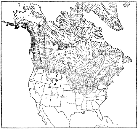
Fig. 47.—Map of North America showing the area buried under ice during the Great Ice Age of the Quaternary period; the three great glacial centers; and the extent of mountain glaciers in the west. (After U. S. Geological Survey.)
The accompanying map shows the area of nearly 4,000,000 square miles of North America covered by ice at the time of maximum glaciation, and also the three great centers of accumulation and dispersal of the ice. The directions of flow from these centers have been determined by the study of the directions of many thousands of glacial scratches on rock ledges. The Labradorean (or Laurentide) glacier spread out 1,600 miles to the south to Long Island and near the mouth of the Ohio River. The vast Keewatin glacier sent a great lobe of ice nearly as far south, that is into northern Missouri. "One of the most marvelous features of the ice dispersion was the great extension of the Keewatin sheet from a low flat center westward and southward over what is now a semiarid plain, rising in the direction in which the ice moved, while the mountain glaciers on the west (Cordilleran region), where now known, pushed eastward but little beyond the foot-hills." (Chamberlin and Salisbury.)
The Labradorean and Keewatin ice sheets everywhere coalesced except in two places. One of these is an area of about 10,000 square miles mostly in southwestern Wisconsin. In spite of several ice invasions during the Ice Age, this area, hundreds of miles north of the southern limit of the ice sheets, was never ice-covered. There is a total absence of records of glaciation within this area, and so we here have an excellent sample of the kind of topography which prevailed over the northern Mississippi Valley just before the advent of the ice. A much smaller, nonglaciated area occurs in northeastern Missouri near the southern limit of ice extension.
The Cordilleran ice sheet was the smallest of the three, and it was probably not such a continuous mass of ice, the higher mountains projecting above its surface. A surprising fact is that neither this ice sheet nor any other overspread northern Alaska, which is well within the Arctic Circle, during the Ice Age. More than likely the temperature was low enough, but precipitation of snow was not sufficient to permit the building up of a great glacier.
At the same time that nearly 4,000,000 square miles of North America were ice-covered, about 600,000 square miles of northern Europe were buried under ice which spread from the one great center over Scandinavia southwest, south, and southeast over most of the British Isles, well into Germany, and well into Russia.
In both North America and Europe the high mountains, well south of the great glacier limits, especially the Sierras, Rockies, Alps, Pyrenees, and Caucasus, supported many large local glaciers in valleys which now contain none at all or only relatively small ones.
Records of glaciation, such as glacial scratches, bowlders, lakes, etc., occur high up in the White and Green Mountains, Adirondacks, Catskills, and the Berkshire Hills, thus proving that the ice must have been at least some thousands of feet thick over New England and New York. We have good reason to believe that even the highest summits, except possibly in the Catskills, from 4,000 to over 6,000 feet above sea level, were completely submerged under the ice. On top of a mountain of Archeozoic granite nearly 4,000 feet in altitude, facing the St. Lawrence Valley in northern New York, the writer has found many fragments of sandstone which were picked off by the ice in the low valley, moved southward a good many miles, and uphill several thousand feet to the top of the mountain. The reader may wonder how a great glacier at least a mile thick in northern New York could have thinned out to disappearance within the short distance to the southern border of the State, but observations on existing large glaciers show that it is quite the habit for them to thin out very rapidly near their margins, thus producing steep ice fronts.
The fact that glacial ice flows as though it were a viscous substance is well known from studies of valley glaciers in the Alps and Alaska, and the great ice sheet of Greenland. A common assumption, either that the land at one of the great centers of ice accumulation during the Ice Age must have been many thousands of feet higher, or that the ice must there have been immensely thick, in order to permit ice flowage so far out from the center, is not necessary. Viscous tar slowly poured upon a level surface will gradually flow out in all directions, and at no time need the tar at the center of accumulation be very much thicker than elsewhere. The movement of glacial ice from the great centers of dispersal during the Ice Age was much the same in principle, only in the case of the glaciers the accumulations of snow and ice were by no means confined to the immediate centers.
The fronts of the vast ice sheets, like those of ordinary valley glaciers, must have undergone many advances and retreats of greater or less consequence. In the northern Mississippi Valley, and also in Europe, there is positive proof for five or six important advances and retreats of the ice which gave rise to the true interglacial stages. The strongest evidence is the presence of successive layers of glacial (morainic) débris piled one upon another, a given layer often having been oxidized, eroded, and even covered with plant life before the next or overlying layer was deposited. Such is the condition of things throughout much of Iowa, where wells sunk into the glacial deposits commonly pass through layers of partly decomposed vegetable matter at depths of from 100 to 300 feet. Near Toronto, Canada, the finding of warm climate plants between two glacial deposits proves that the climate there during an interglacial stage was much like that of the southern States to-day. During the great interglacial stages the vast glaciers were notably restricted in size, and in some or possibly all, cases they may have wholly disappeared from the continent.
In former years there was a tendency to ascribe mighty erosive power to the vast slow-moving ice sheets, but to-day scarcely any geologist would hold that the ice really produced large valleys solely by ice erosion, or that mountains were notably cut down. Throughout the glaciated region, especially toward the north, the deep preglacial residual soils and rotten rocks were nearly all scoured off by the passage of the ice. That the ice, where properly shod with rock fragments, actually eroded to at least little depths into hard and fresh rocks is well known, but the evidence is clear and conclusive that the preglacial hills and mountains, and most of the valleys (including all the large ones), were rarely more than a little modified in shape and size.
One of the principal effects of the Ice Age is the widespread distribution of glacial deposits, and other deposits which were formed under water in direct association with the ice. Such materials have been described in the chapter on “Glaciers and Their Work.”
As a direct result of the Ice Age, many thousands of lakes came into existence throughout the glaciated region where few, if any, previously existed. Many of these lasted only while the ice was present because their waters were held up by walls of ice acting as dams. Thousands of others still persist, most of these having their water levels maintained by dams of glacial débris left by the ice across valleys. Good examples of lakes of both types, including a summary of the remarkable history of the Great Lakes, are considered in the chapter on “A Study of Lakes.”
Many drainage changes, gorges, and waterfalls have also directly resulted from the great Ice Age. In fact it is not too much to say that practically all true gorges and waterfalls of the glaciated region have originated as a direct result of the Ice Age. The most remarkable combination of waterfall and gorge thus produced is that of the world-famous Niagara, described in the chapter on “Stream Work.” Not only are Niagara Falls and gorge of postglacial origin but there was no Niagara River as such before the Ice Age. In New York the well-known Ausable Chasm, Trenton Falls Gorge, and Watkins Glen are all excellent examples of gorges cut since the Ice Age by streams which, because their old valleys were filled with glacial débris, have been forced to take new courses. A gorge of very special interest is that at Little Falls in central New York. This gorge, two miles long, with its precipitous walls hundreds of feet high, is the most important gateway for traffic between the Atlantic border and the Great Lakes region. The bottom of this defile contains six tracks of the New York Central and West Shore Railroads, the Barge Canal, an important highway, and the Mohawk River. Before the Ice Age there was a stream divide instead of a gorge, several hundred feet above the present river level. During a late stage of the Ice Age, when the Great Lakes drained through the Mohawk Valley, a tremendous volume of water passed over the divide and cut it down to form nearly all of the gorge except the inner or bottom trench which has since been eroded by the Mohawk River.
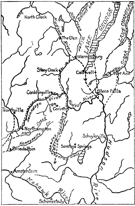
Fig. 48.—Sketch map of the region between Lake George and Schenectady, New York, showing how certain of the main drainage courses have been revolutionized by the great retreating ice sheet and the deposits it left. Preglacial courses shown by dotted lines only where essentially different from the present streams. (By the author, as published by New York State Museum.)
Only a few of the numerous stream changes directly due to the Ice Age will be briefly referred to. Certain of the principles involved are exceptionally well illustrated in the general vicinity of Saratoga Springs and Lake George, New York. During the retreat of the great glacier a lobe of ice occupied the Lake George Valley and forced the Hudson River west over a divide at Stony Creek. Then, because of heavy glacial deposits near Corinth, the Hudson could not continue south through what had been the preglacial valley of Luzerne River, but it was forced eastward over a divide in a low mountain ridge to Glens Falls. The remarkable shift of the Sacandaga River from its preglacial channel was caused by the building up of a great morainic ridge across the valley in the vicinity of Broadalbin.
The drainage of the basin of the upper Ohio River has also been revolutionized as a result of the glaciation. All the drainage of western Pennsylvania passed northward into Lake Erie just before the Ice Age instead of southwestward through the Ohio River as at present.
Rivers as large as the Mississippi and the Missouri were also more or less locally deflected from their preglacial courses. Thus the Missouri, which in preglacial time followed the James River Valley of eastern South Dakota, was forced, by a great lobe of retreating ice, to find its present course many miles farther west.
How long ago did the Ice Age end? In seeking an answer to this question we should bear in mind not only the fact that the Ice Age ended at different times, according to latitude, the more southern districts having been first freed from ice, but also the fact that approximately 4,000,000 square miles of the polar regions are now ice-covered, so that in a real sense those portions of the earth are still in an Ice Age. Some of the best estimates of the length of postglacial time for a given place are based upon the rate of recession of Niagara Falls, the average of the estimates being about 25,000 years. The evidence for this conclusion is briefly set forth in Chapter III. A careful study of the rate of recession of St. Anthony Falls, Minnesota, has led to the conclusion that the last retreat of the ice occurred there from 10,000 to 16,000 years ago. Certain clays deposited under tidewater since the last withdrawal of ice in Sweden show a remarkable succession of alternating layers thought to represent seasonal changes. By counting the layers it has been estimated that Stockholm was freed from ice only 9,000 years ago.
Although the actual duration of the Ice Age is by no means accurately known, we can be quite sure that the time represented is far longer than that of postglacial time. That it must have lasted fully 500,000 years seems certain when due consideration is given to amount of time necessary to bring about the repeated changes of climate between the glacial and interglacial stages; the amount of plant accumulation during the interglacial stages; the amount of weathering and erosion of the various layers of glacial deposits. Some estimates run as high as 1,500,000 years for the duration of the Ice Age, and an average is about 1,000,000 years, which probably indicates, at least roughly, the order of magnitude of the time involved.
When it is considered not only that the fact of the great Ice Age was not even thought of until 1837, but also that many factors enter into the general problem of the climate of geologic time, it is not surprising that the cause (or causes) of the glacial climate is still not definitely known. A few of the various hypotheses which have been advocated to account for the glacial climate will now be very briefly referred to. One is that the increased cold (not more than 10 to 15 degrees for the yearly average) was brought about by the notably increased altitudes of late Tertiary and early Quaternary times in northern North America and Europe. In this connection it is interesting to note that the four times of real glaciation during geologic time (mid-Proterozoic, early Paleozoic, late Paleozoic, and early Cenozoic) did occur directly after great crustal disturbances and notable uplifts of land. According to this hypothesis the interglacial stages would have to be explained by a rather unreasonable assumption of repeated rising and sinking of the glaciated lands.
Another hypothesis, long held in favor, is based upon certain astronomical considerations. Thus we now have winter in the northern hemisphere when the earth is nearest the sun, but in about 10,500 years, due to wobbling of the earth on its axis, our winter will occur when the earth is farthest from the sun, thus making the winters longer and colder, and the summers shorter and hotter. After a much longer period of time the earth will be millions of miles farther from the sun in winter than in summer and this would still further accentuate the length and coldness of the winters. The interglacial stages represent the 10,500 year periods when the earth in winter (northern hemisphere) is nearest the sun. A difficulty in the way of accepting this hypothesis is that it is inconceivable that each glacial and interglacial stage lasted only 10,500 years. Another objection to the hypothesis as an explanation of Ice Ages is that it is directly opposed by the fact of widespread glaciation at low latitudes either side of the equator during the late Paleozoic Ice Age.
Another hypothesis is based upon variations in quantity of carbonic acid gas and water vapor in the air. Increase or decrease of these constituents causes increase or decrease of temperature because they have high capacities for absorbing heat. “The great elevation of the land at the close of the Tertiary seems to afford conditions favorable both for the consumption of carbon dioxide in large quantities (by weathering of rocks) and for the reduction of the water content of the air. Depletion of these heat-absorbing elements was equivalent to the thinning of the thermal blanket which they constitute. If it was thinned, the temperature was reduced.... By variations in the consumption of carbon dioxide, especially in its absorption and escape from the ocean, the hypothesis attempts to explain the periodicity of glaciation (i.e., glacial and interglacial stages).” (Chamberlin and Salisbury.)
Still another suggested explanation is based upon variability of amount of heat radiated by the sun. Slight variations are now known to take place, and possibly in the past during certain periods of time these variations may have been sufficiently great to cause a glacial climate with interglacial stages.
Here, as in the case of so many other great natural phenomena, a single, simple explanation does not seem sufficient to account for all the features of the several well-known glacial epochs of geologic time. Two or more hypotheses, or parts of hypotheses, must more than likely be combined to explain a particular Ice Age.
CHAPTER XVII
EVOLUTION OF PLANTS
H
HAVE we any knowledge regarding the beginning of life on our planet? Our answer to this question must be decidedly in the negative. We can, however, be very positive in regard to two important matters concerning life in early geological time, namely, that plants must have existed before animals, and that the very oldest known (Archeozoic) rocks of the earth contain vestiges of organisms. We may be sure that plants preceded animals because animal life ultimately depends upon plants for its food supply or, in other words, all animals could never have been carnivorous. Now, if we can prove that organisms existed during Archeozoic time, it is evident that plants at least must have lived in that oldest known era of earth history. That living things did then exist is proved by the common occurrence of graphite, a crystallized form of carbon, in the oldest known of the Archeozoic rocks. The facts that flakes of graphite are abundantly scattered through many layers of strata of Archeozoic Age, and that adjacent layers of strata contain such varying amounts of graphite, render it practically certain that such graphite represents the carbon of organisms. Graphite existing under such conditions could not be of igneous origin. Carbonaceous or bituminous strata, so called because they contain more or less decomposed organic matter, would, when crystallized under conditions of metamorphism, yield graphite-bearing rocks exactly like those of Archeozoic Age, and there is every reason to believe that this was their origin. But, since only graphite (carbon) of the Archeozoic organisms remains, the rest having disappeared through chemical change or decomposition, it is impossible to say whether much or all of it represents original plants or animals. In any case we can be very sure about the existence of plants (probably very simple or primitive types) in Archeozoic time, but the presence of any form of animal life has not been proved.
In the next, or Proterozoic era, some plants and animals of definite types are known to have existed and, from here on in the present chapter, it is our purpose to consider the salient points in the geological history of plants, taking up the main types in the regular order of their appearance from the remote Proterozoic days to the present. The very oldest known definitely determinable fossils of any kind are the more or less rounded masses of crudely concentric layers of carbonate of lime from one to fifteen inches in diameter found in middle Proterozoic limestone of western Ontario, Canada. Similar forms are abundant in late Proterozoic strata of Montana. They occur in large numbers as layers or reefs, in many cases repeating themselves through hundreds or even thousands of feet of strata. Careful studies have shown that these forms are the limey secretions of some of the very simplest types of plants, that is thallophytes (e.g., seaweeds), which lived in water.
Before proceeding to describe the plants of Paleozoic and later time, the reader should be impressed with the important fact that plants of higher and higher types came into existence throughout geological time in almost exactly the botanical order of their classification, that is to say, from the very simplest types (thallophytes) of Proterozoic time there were gradually evolved, through the long geological ages, higher and higher plant forms reaching a climax in the complex and highly organized plants of the present time. This is the most significant general fact in regard to the geological history of plants. For the convenience of the reader the largest subdivisions in the classification of plants are here given.
OUTLINE CLASSIFICATION OF PLANTS
I. Cryptogams (seedless and flowerless) 1. Thallophytes (e.g., seaweeds, mushrooms) 2. Bryophytes (e.g., mosses) 3. Pteridophytes (e.g., “club mosses,” "horsetails," ferns)

II. Pteridosperms (seed-bearing, flowerless) { (e.g., seed ferns—wholly extinct)
III. Phanerogams (seed-bearing, flowering) 1. Gymnosperms (e.g., cycads, conifers) 2. Angiosperms (e.g., grasses, lilies, oaks, roses)
Throughout the first two periods—Cambrian and Ordovician—of the Paleozoic era, plant life appears to have made little or no progress toward higher forms. The very simple Thallophytes (e.g., seaweeds) continued to secrete concentric layers of carbonate of lime in almost exactly the same way as during the middle and late Proterozoic era. Remarkable reefs of such forms occur in the late Cambrian limestone near Saratoga Springs, New York, where one locality has been set aside as a state park. During the Ordovician there were seaweeds of the more familiar branching types without carbonate of lime supports, and these have left very perfect impressions in some of the Ordovician strata.
During the Silurian period seaweeds continued, as, in fact, they did throughout succeeding geologic time to the present. The Silurian strata seem to contain some vestiges of the first-known land plants, though the records are meager and some of the specimens are of a doubtful character. Most interesting of all is a fern or fernlike plant found in France. When we consider the profusion of land plants (all of relatively simple types) of the next or Devonian period, it seems certain that their progenitors must have existed in the Silurian, and their remains may very likely be discovered.
Beginning with the Devonian period of the Paleozoic era the records show that important advances had taken place in the evolution of the plant kingdom. Among the very simple Thallophyte plants some seaweeds of unusually large size occur in fossil form, but the important fact is that all the principal subdivisions of the typical higher non-flowering plants (Pteridophytes) as well as Pteridosperms, and even some primitive representatives of the lower order flowering plants (gymnosperms) were well represented in the Devonian. Our knowledge of land plants earlier than the Devonian amounts to almost nothing and they certainly could not have been at all prominent, but the fossil records make it very clear that many Devonian land areas were clad with rich and diversified plant life. There were even forests, probably the first on earth, but they were far different, both in general and in particular, from those of to-day because the trees were all of exceptionally low organization types. During the next two periods—Mississippian and Pennsylvanian—there was no really important progress in the evolution of plants, and since these remarkable types of land plants have left such wonderfully preserved records in strata of the Pennsylvanian or great Coal Age, we shall proceed to descriptions of the main types of that time, especially those which contributed to the formation of beds of coal.
As shown by the abundant records, the land plant life of Pennsylvanian time must have been not only prolific but exceedingly varied. Thousands of species have been unearthed from the coal-bearing formations alone, and these must represent only a fraction of all species of plants which lived during the period. Most prominent of all were the giant Lycopods constituting the lowest main subdivision of the Pteridophytes (see above classification). These great, non-flowering plants were at once the biggest, most common and conspicuous trees of the extensive swamp forests, and they were the greatest contributors to the formation of coal (Plate 15). Many species have been described. They commonly attained heights of 50 to 100 feet and diameters of 2 to 6 feet. In one important type the fairly numerous branches bristled with stiff, needle-shaped leaves. When the leaves dropped off the older or trunk portions, scars were left spirally arranged around the trunks of the trees. In another important type the leaf scars were vertically arranged on the lower portions of the tree trunks. The upper portions of the trunks (rarely branched) were thickly set with long, slender leaves, which in some species were two or three feet long. An interesting fact is that the inner parts of the trunks of the great Lycopods were filled with soft, pithy material. This explains why the fossil trees are nearly always flattened out, as a result of burial within the earth. The nonbranching type of Lycopod has been totally extinct for millions of years, while the branching type is to-day represented only by small, mostly delicate, trailing plants familiarly known as “club mosses” and “ground pines.” The most conspicuous trees of the great Pennsylvanian lowlands and swamps have, indeed, left meager modern representatives, and here we have an excellent illustration of a once prominent group of plants which has dwindled away almost to extinction.
Another common type of Pennsylvanian vegetation was the so-called “horsetail” plant or giant rush. The much smaller scouring rush, represented by several species to-day, is the direct descendant of this type which, during later Paleozoic time, grew to be 50 to 90 feet high and 1 to 2 feet in diameter. The long, slender trunks filled with pith were segmented with variously shaped leaves arranged in whorls around the joints. A fine, vertical-fluted structure without leaf scars characterized the surfaces of the trunk.
Recent study has shown that many of the Pennsylvanian plants, long classed as true ferns, were really “seed ferns,” as described below. Many of the true ferns grew to be real trees up to fifty or sixty feet high, but all Paleozoic types were primitive in structure as compared with modern ferns.
Very remarkable among the later Paleozoic plants were the Pteridosperms, represented by the so-called “seed ferns.” These now wholly extinct plants seem to have formed the connecting link between the seedless, flowerless plants (Cryptogams) and the seed-bearing, flowering plants (Phanerogams), because they bore seeds but not flowers. Many of them were small and herbaceous, but others were tall trees, in general appearance resembling the tree ferns. “Seed ferns,” which play such an important part in the evolution of plants, are not known to have existed after Paleozoic time.
During the latter half of the Paleozoic era some very primitive types of flowering plants (Gymnosperms) existed. Most abundant of these were the so-called Cordaites, which were the tallest trees of the time, some having reached heights of over 100 feet. The upper portions only bore numerous branches supplied with many simple, parallel-veined, strap-shaped leaves up to six feet long and six inches wide. Excepting the pithy cores the trunks of these trees were of real wood covered with thick bark. Trees of this kind became extinct in the early Mesozoic era.
Very late in the Paleozoic (Permian period) two other types of the simple flowering plants (Gymnosperms) made their appearance. These were the cycads and conifers, which were the most conspicuous trees during the first two periods of the Mesozoic era. The cycads reached their culmination in the Jurassic period, but they still exist in modified form in some parts of the world. The short, stout trunk was crowned with long, stiff, palm-like leaves. In fact, the cycads are distantly related to the palms, which belong to a higher group of plants. Some specimens of cycads, especially from the Mesozoic strata of South Dakota, are so wonderfully fossilized that even the detailed structures of trunks, leaves, flowers, and seeds are so perfectly preserved that almost as much is known about these plants of millions of years ago as though they were living forms.
The conifers, with which are classed present-day pines, spruces, and many other evergreen trees, gradually took on a more modern aspect, so that late in the Mesozoic era they were much like those now living. Among the most interesting trees were the sequoias, to which the living “big trees” and red-woods of California belong. These began in relatively late Mesozoic time, reached their climax in numbers, variety of species, and widespread distribution in the early Cenozoic era; and are now almost extinct, being represented by only two species in local portions of California. Cordaites, trees which were so large and abundant in later Paleozoic time, were reduced to extinction in the early Mesozoic era.
During Mesozoic time the Thallophytes, represented by seaweeds, were common. Among the Pteridophytes the ferns and “horsetail” plants were fairly common, but the very large forms gradually gave way to much smaller ones during Mesozoic time. The giant Lycopods of later Paleozoic time dwindled almost to extinction even in early Mesozoic time, so that from that time to the present they have been very small and relatively insignificant.
Tens of millions of years of earth history had passed before the true flowering plants—the Angiosperms—appeared upon the earth. The Cretaceous period marks their advent. So far as known, these plants originated along the eastern side of North America, and very soon after their establishment they spread over the earth with amazing rapidity and dominated the vegetation as they do to-day, more than half of the existing species of plants being Angiosperms. Among the common types which have been unearthed from Cretaceous strata are palms, grasses, maples, oaks, elms, figs, magnolias, willows, beeches, chestnuts, and poplars.
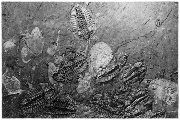
Plate 13.—A Slab of Very Early Paleozoic (Cambrian) Rock, Covered with Some of the Oldest Known Definitely Determinable Animal Remains. These creatures lived in a sea which overspread the site of the Rocky Mountains of southern Canada fully 25,000,000 years ago. Most of the fossils are trilobites (including some very small ones) and other related crustacean forms (lighter portions). (After C. D. Wolcott, Smithsonian Institution, Washington, D. C.)
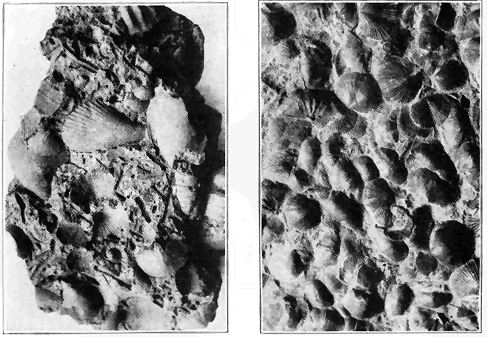
Plate 14.—(a) Photographs of Small Slabs of Ordovician Strata Full of Fossils. These slabs are actual bits of sea bottom at least 20,000,000 years old. The left picture shows “stone-lily” stems, so-called “sea mosses,” brachiopods. Right picture shows various species of brachiopods. (Photo by the author.)
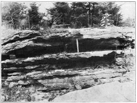
Plate 14.—(b) An Outcrop of Middle Ordovician Stratified Limestone in Northern New York. This ledge is full of fossils similar to those above. The material was deposited on the floor of the Ordovician sea which overspread much of the continent. (Photo by the author.)
The introduction of the higher flowering plants (Angiosperms) "was, perhaps, the most important and far-reaching event in the whole history of vegetation, not only because they almost immediately became dominant, but also because of their influence upon the animal life of the succeeding periods. Hardly had flowers appeared, before a great horde of insects, which fed upon their honey or pollen, seem to have sprung into existence. The nutritious grasses and the various nuts, seeds, and fruits afforded a better food for noncarnivores than ever before in the history of the world. It was to be expected, therefore, that some new type of animal life would be developed to take advantage of this superior food supply. As we shall see in the discussion of the Tertiary (next chapter), the mammals, which kept a subordinate position throughout the Mesozoic, rapidly took on bulk and variety and acquired possession of the earth as soon as they became adapted to this new food, quickly supplanting the great reptiles of the Mesozoic." (Cleland.)
During the present or Cenozoic era vegetation gradually took on a more and more modern aspect until the existing species were developed. The grasses especially developed and spread rapidly, but the cereals did not evolve until late in the era. Certain single-celled plants, called diatoms, may be especially mentioned, for they must have literally swarmed in some of the Tertiary seas which spread over parts of the present lands. "The microscopic plants which form siliceous shells, called diatoms, make extensive deposits in some places. One stratum near Richmond, Virginia, is thirty feet thick and is many miles in extent; another, near Monterey, California, is fifty feet thick, and the material is as white and fine as chalk, which it resembles in appearance; another, near Bilin, in Bohemia, is fourteen feet thick.... Ehrenberg has calculated that a cubic inch of the fine, earthy rock contains about forty-one thousand millions of organisms. Such accumulations of diatoms are made both in fresh waters and salt, and in those of the ocean at all depths." (J. D. Dana.)