VOLUME XVI SLICE I L to Lamellibranchia (continued 9)
Reading edition
His éloge at the Academy of Moral and Political Science, of which he was a member, was pronounced by the comte de Rémusat (February 16, 1845), and a Notice historique by F. A. M. Mignet was read on the 2nd of May 1857. See also notices by Émile Darnaud (Paris, 1874), “Marcus” (Paris, 1879), P. Legendre in Hommes de la révolution (Paris, 1882), E. Guillon, Lakanal et l’instruction publique (Paris, 1881). For details of the reports submitted by him to the government see M. Tourneux, “Histoire de l’instruction publique, actes et déliberations de la convention, &c.” in Bibliog. de l’hist. de Paris (vol. iii., 1900); also A. Robert and G. Cougny, Dictionnaire des parlementaires (vol. ii., 1890).

LAKE, GERARD LAKE, 1st Viscount (1744-1808), British general, was born on the 27th of July 1744. He entered the foot guards in 1758, becoming lieutenant (captain in the army) 1762, captain (lieut.-colonel) in 1776, major 1784, and lieut.-colonel in 1792, by which time he was a general officer in the army. He served with his regiment in Germany in 1760-1762 and with a composite battalion in the Yorktown campaign of 1781. After this he was equerry to the prince of Wales, afterwards George IV. In 1790 he became a major-general, and in 1793 was appointed to command the Guards Brigade in the duke of York’s army in Flanders. He was in command at the brilliant affair of Lincelles, on the 18th of August 1793, and served on the continent (except for a short time when seriously ill) until April 1794. He had now sold his lieut.-colonelcy in the guards, and had become colonel of the 53rd foot and governor of Limerick. In 1797 he was promoted lieut.-general. In the following year the Irish rebellion broke out. Lake, who was then serving in Ireland, succeeded Sir Ralph Abercromby in command of the troops in April 1798, issued a proclamation ordering the surrender of all arms by the civil population of Ulster, and on the 21st of June routed the rebels at Vinegar Hill (near Enniscorthy, Co. Wexford). He exercised great, but perhaps not unjustified, severity towards all rebels found in arms. Lord Cornwallis now assumed the chief command in Ireland, and in August sent Lake to oppose the French expedition which landed at Killala Bay. On the 29th of the same month Lake arrived at Castlebar, but only in time to witness the disgraceful rout of the troops under General Hely-Hutchinson (afterwards 2nd earl of Donoughmore); but he retrieved this disaster by compelling the surrender of the French at Ballinamuck, near Cloone, on the 8th of September. In 1799 Lake returned to England, and soon afterwards obtained the command in chief in India. He took over his duties at Calcutta in July 1801, and applied himself to the improvement of the Indian army, especially in the direction of making all arms, infantry, cavalry and artillery, more mobile and more manageable. In 1802 he was made a full general.
On the outbreak of war with the Mahratta confederacy in 1803 General Lake took the field against Sindhia, and within two months defeated the Mahrattas at Coel, stormed Aligahr, took Delhi and Agra, and won the great victory of Laswari (November 1st, 1803), where the power of Sindhia was completely broken, with the loss of thirty-one disciplined battalions, trained and officered by Frenchmen, and 426 pieces of ordnance. This defeat, followed a few days later by Major-General Arthur Wellesley’s victory at Argaum, compelled Sindhia to come to terms, and a treaty with him was signed in December 1803. Operations were, however, continued against his confederate, Holkar, who, on the 17th of November 1804, was defeated by Lake at Farrukhabad. But the fortress of Bhurtpore held out against four assaults early in 1805, and Cornwallis, who succeeded Wellesley as governor-general in July of that year—superseding Lake at the same time as commander-in-chief—determined to put an end to the war. But after the death of Cornwallis in October of the same year, Lake pursued Holkar into the Punjab and compelled him to surrender at Amritsar in December 1805. Wellesley in a despatch attributed much of the success of the war to Lake’s “matchless energy, ability and valour.” For his services Lake received the thanks of parliament, and was rewarded by a peerage in September 1804. At the conclusion of the war he returned to England, and in 1807 he was created a viscount. He represented Aylesbury in the House of Commons from 1790 to 1802, and he also was brought into the Irish parliament by the government as member for Armagh in 1799 to vote for the Union. He died in London on the 20th of February 1808.
See H. Pearse, Memoir of the Life and Services of Viscount Lake (London, 1908); G. B. Malleson, Decisive Battles of India (1883); J. Grant Duff, History of the Mahrattas (1873); short memoir in From Cromwell to Wellington, ed. Spenser Wilkinson.
LAKE. Professor Forel of Switzerland, the founder of the science of limnology (Gr. λίμνη, a lake), defines a lake (Lat. lacus) as a mass of still water situated in a depression of the ground, without direct communication with the sea. The term is sometimes applied to widened parts of rivers, and sometimes to bodies of water which lie along sea-coasts, even at sea-level and in direct communication with the sea. The terms pond, tarn, loch and mere are applied to smaller lakes according to size and position. Some lakes are so large that an observer cannot see low objects situated on the opposite shore, owing to the lake-surface assuming the general curvature of the earth’s surface. Lakes are nearly universally distributed, but are more abundant in high than in low latitudes. They are abundant in mountainous regions, especially in those which have been recently glaciated. They are frequent along rivers which have low gradients and wide flats, where they are clearly connected with the changing channel of the river. Low lands in proximity to the sea, especially in wet climates, have numerous lakes, as, for instance, Florida. Lakes may be either fresh or salt, according to the nature of the climate, some being much more salt than the sea itself. They occur in all altitudes; Lake Titicaca in South America is 12,500 ft. above sea-level, and Yellowstone Lake in the United States is 7741 ft. above the sea; on the other hand, the surface of the Caspian Sea is 86 ft., the Sea of Tiberias 682 ft. and the Dead Sea 1292 ft. below the level of the ocean.
The primary source of lake water is atmospheric precipitation, which may reach the lakes through rain, melting ice and snow, springs, rivers and immediate run-off from the land-surfaces. The surface of the earth, with which we are directly in touch, is composed of lithosphere, hydrosphere and atmosphere, and these interpenetrate. Lakes, rivers, the water-vapour of the atmosphere and the water of hydration of the lithosphere, must all be regarded as outlying portions of the hydrosphere, which is chiefly made up of the great oceans. Lakes may be compared to oceanic islands. Just as an oceanic island presents many peculiarities in its rocks, soil, fauna and flora, due to its isolation from the larger terrestrial masses, so does a lake present peculiarities and an individuality in its physical, chemical and biological features, owing to its position and separation from the waters of the great oceans.
Origin of Lakes.—From the geological point of view, lakes may be arranged into three groups: (A) Rock-Basins, (B) Barrier-Basins and (C) Organic Basins.
A. Rock-Basins have been formed in several ways:—
1. By slow movements of the earth’s crust, during the formation of mountains; the Lake of Geneva in Switzerland and the Lake of Annecy in France are due to the subsidence or warping of part of the Alps; on the other hand, Lakes Stefanie, Rudolf, Albert Nyanza, Tanganyika and Nyasa in Africa, and the Dead Sea in Asia Minor, are all believed to lie in a great rift or sunken valley.
2. By Volcanic Agencies.—Crater-lakes formed on the sites of dormant volcanoes may be from a few yards to several miles in width, have generally a circular form, and are often without visible outlet. Excellent examples of such lakes are to be seen in the province of Rome (Italy) and in the central plateau of France, where M. Delebecque found the Lake of Issarlès 329 ft. in depth. The most splendid crater-lake is found on the summit of the Cascade range of Southern Oregon (U.S.A.). This lake is 2000 ft. in depth.
3. By Subsidence due to Subterranean Channels and Caves in Limestone Rocks.—When the roofs of great limestone caves or underground lakes fall in, they produce at the surface what are called limestone sinks. Lakes similar to these are also found in regions abounding in rock-salt deposits; the Jura range offers many such lakes.
4. By Glacier Erosion.—A. C. Ramsay has shown that innumerable lakes of the northern hemisphere do not lie in fissures produced by underground disturbances, nor in areas of subsidence, nor in synclinal folds of strata, but are the results of glacial erosion. Many flat alluvial plains above gorges in Switzerland, as well as in the Highlands of Scotland, were, without doubt, what Sir Archibald Geikie calls glen-lakes, or true rock-basins, which have been filled up by sand and mud brought into them by their tributary streams.
B. Barrier-Basins.—These may be due to the following causes:—
1. A landslip often occurs in mountainous regions, where strata, dipping towards the valley, rest on soft layers; the hard rocks slip into the valley after heavy rains, damming back the drainage, which then forms a barrier-basin. Many small lakes high up in the Alps and Pyrenees are formed by a river being dammed back in this way.
2. By a Glacier.—In Alaska, in Scandinavia and in the Alps a glacier often bars the mouth of a tributary valley, the stream flowing therein is dammed back, and a lake is thus formed. The best-known lake of this kind is the Märjelen Lake in the Alps, near the great Aletsch Glacier. Lake Castain in Alaska is barred by the Malaspina Glacier; it is 2 or 3 m. long and 1 m. in width when at its highest level; it discharges through a tunnel 9 m. in length beneath the ice-sheet. The famous parallel roads of Glen Roy in Scotland are successive terraces formed along the shores of a glacial lake during the waning glacial epoch. Lake Agassiz, which during the glacial period occupied the valley of the Red River, and of which the present Lake Winnipeg is a remnant, was formed by an ice-dam along the margin of two great ice-sheets. It is estimated to have been 700 m. in length, and to have covered an area of 110,000 sq. m., thus exceeding the total area of the five great North American lakes: Superior (31,200), Michigan (22,450), Huron with Georgian Bay (23,800), Erie (9960) and Ontario (7240).
3. By the Lateral Moraine of an Actual Glacier.—These lakes sometimes occur in the Alps of Central Europe and in the Pyrenees Mountains.
4. By the Frontal Moraine of an Ancient Glacier.—The barrier in this case consists of the last moraine left by the retreating glacier. Such lakes are abundant in the northern hemisphere, especially in Scotland and the Alps.
5. By Irregular Deposition of Glacial Drift.—After the retreat of continental glaciers great masses of glacial drift are left on the land-surfaces, but, on account of the manner in which these masses were deposited, they abound in depressions that become filled with water. Often these lakes are without visible outlets, the water frequently percolating through the glacial drift. These lakes are so numerous in the north-eastern part of North America that one can trace the southern boundary of the great ice-sheet by following the southern limit of the lake-strewn region, where lakes may be counted by tens of thousands, varying from the size of a tarn to that of the great Laurentian lakes above mentioned.
6. By Sand drifted into Dunes.—It is a well-known fact that sand may travel across a country for several miles in the direction of the prevailing winds. When these sand-dunes obstruct a valley a lake may be formed. A good example of such a lake is found in Moses Lake in the state of Washington; but the sand-dunes may also fill up or submerge river-valleys and lakes, for instance, in the Sahara, where the Shotts are like vast lakes in the early morning, and in the afternoon, when much evaporation has taken place, like vast plains of white salt.
7. By Alluvial Matter deposited by Lateral Streams.—If the current of a main river be not powerful enough to sweep away detrital matter brought down by a lateral stream, a dam is formed causing a lake. These lakes are frequently met with in the narrow valleys of the Highlands of Scotland.
8. By Flows of Lava.—Lakes of this kind are met with in volcanic regions.
C. Organic Basins.—In the vast tundras that skirt the Arctic Ocean in both the old and the new world, a great number of frozen ponds and lakes are met with, surrounded by banks of vegetation. Snow-banks are generally accumulated every season at the same spots. During summer the growth of the tundra vegetation is very rapid, and the snow-drifts that last longest are surrounded by luxuriant vegetation. When such accumulations of snow finally melt, the vegetation on the place they occupied is much less than along their borders. Year after year such places become more and more depressed, comparatively to the general surface, where vegetable growth is more abundant, and thus give origin to lakes.
It is well known that in coral-reef regions small bays are cut off from the ocean by the growth of corals, and thus ultimately fresh-water basins are formed.
Life History of Lakes.—From the time of its formation a lake is destined to disappear. The historical period has not been long enough to enable man to have watched the birth, life and death of any single lake of considerable size, still by studying the various stages of development a fairly good idea of the course they run can be obtained.
In humid regions two processes tend to the extinction of a lake, viz. the deposition of detrital matter in the lake, and the lowering of the lake by the cutting action of the outlet stream on the barrier. These outgoing streams, however, being very pure and clear, all detrital matter having been deposited in the lake, have less eroding power than inflowing streams. One of the best examples of the action of the filling-up process is presented by Lochs Doine, Voil and Lubnaig in the Callander district of Scotland. In post-glacial times these three lochs formed, without doubt, one continuous sheet of water, which subsequently became divided into three different basins by the deposition of sediment. Loch Doine has been separated from Loch Voil by alluvial cones laid down by two opposite streams. At the head of Loch Doine there is an alluvial flat that stretches for 1½ m., formed by the Lochlarig river and its tributaries. The long stretch of alluvium that separates Loch Voil from Loch Lubnaig has been laid down by Calair Burn in Glen Buckie, by the Kirkton Burn at Balquhidder, and by various streams on both sides of Strathyre. Loch Lubnaig once extended to a point ¾ m. beyond its present outlet, the level of the loch being lowered about 20 ft. by the denuding action of the river Leny on its rocky barrier.
In arid regions, where the rainfall is often less than 10 ins. in the year, the action of winds in the transport of sand and dust is more in evidence than that of rivers, and the effects of evaporation greater than of precipitation. Salt and bitter lakes prevail in these regions. Many salt lakes, such as the Dead Sea and the Great Salt Lake, are descended from fresh-water ancestors, while others, like the Caspian and Aral Seas, are isolated portions of the ocean. Lakes of the first group have usually become salt through a decrease in the rainfall of the region in which they occur. The water begins to get salt when the evaporation from the lake exceeds the inflow. The inflowing waters bring in a small amount of saline and alkaline matter, which becomes more and more concentrated as the evaporation increases. In lakes of the second group the waters were salt at the outset. If inflow exceeds evaporation they become fresher, and may ultimately become quite fresh. If the evaporation exceeds the inflow they diminish in size, and their waters become more and more salt and bitter. The first lake which occupied the basin of the Great Salt Lake of Utah appears to have been fresh, then with a change of climate to have become a salt lake. Another change of climate taking place, the level of the lake rose until it overflowed, the outlet being by the Snake river; the lake then became fresh. This expanded lake has been called Lake Bonneville, which covered an area of about 17,000 sq. m. Another change of climate in the direction of aridity reduced the level of the lake below the level of the outlet, the waters became gradually salt, and the former great fresh-water lake has been reduced gradually to the relatively small Great Salt Lake of the present day. The sites of extinct salt lakes yield salt in commercial quantities.
The Water of Lakes.—(a) Composition.—It is interesting to compare the quantity of solid matter in, and the chemical composition of, the water of fresh and salt lakes:—
Total Solids by Evaporation expressed in Grams per Litre.
Great Salt Lake (Russell) 238.12
Lake of Geneva (Delebecque) 0.1775
The following analysis of a sample of the water of the Great Salt Lake (Utah, U.S.A.) is given by I. C. Russell:—
Grams per Litre. Probable Combination.
Na 75.825 NaCl 192.860
K 3.925 K2SO4 8.756
Li 0.021 Li2SO4 0.166
Mg 4.844 MgCl2 15.044
Ca 2.424 MgSO4 5.216
Cl 128.278 CaSO4 8.240
SO3 12.522 Fe2O3 + Al2O3 0.004
O in sulphate 2.494 SiO2 0.018
Fe2O3 + Al2O3 0.004 Surplus SO3 0.051
SiO2 0.018
Bo2O3 trace
Br3 faint trace
The following analyses of the waters of other salt lakes are given by Mr J. Y. Buchanan (Art. “Lake,” Ency. Brit., 9th Ed.), an analysis of sea-water from the Suez Canal being added for comparison:—
Koko-nor. Aral Sea Caspian Sea. Urmia Sea. Dead Sea. Lake Van. Suez Canal, Ismailia.
Open. Karabugas.
Specific Gravity 1.00907 .. 1.01106 1.26217 1.17500 .. 1.01800 1.03898
Percentage of Salt 1.11 1.09 1.30 28.5 22.28 22.13 1.73 5.1
Name of Salt. Grams of Salt per 1000 Grams of Water.
Bicarbonate of Lime 0.6804 0.2185 0.1123 .. .. .. .. 0.0072
Bicarbonate of Iron 0.0053 .. 0.0014 .. .. .. .. 0.0069
Bicarbonate of Magnesia 0.6598 .. .. .. .. .. 0.4031 ..
Carbonate of Soda .. .. .. .. .. .. 5.3976 ..
Phosphate of Lime 0.0028 .. 0.0021 .. .. .. 5.3976 0.0029
Sulphate of Lime .. 1.3499 0.9004 .. 0.7570 0.8600 .. 1.8593
Sulphate of Magnesia 0.9324 2.9799 3.0855 61.9350 13.5460 .. 0.2592 3.2231
Sulphate of Soda 1.7241 .. .. .. .. .. 2.5673 ..
Sulphate of Potash .. .. .. .. .. .. 0.5363 ..
Chloride of Sodium 6.9008 6.2356 8.1163 83.2840 192.4100 76.5000 8.0500 40.4336
Chloride of Potassium 0.2209 0.1145 0.1339 9.9560 .. 23.3000 .. 0.6231
Chloride of Rubidium 0.0055 .. 0.0034 0.2510 .. .. .. 0.0265
Chloride of Magnesium .. 0.0003 0.6115 129.3770 15.4610 95.6000 .. 4.7632
Chloride of Calcium .. .. .. .. 0.5990 22.4500 .. ..
Bromide of Magnesium 0.0045 .. 0.0081 0.1930 .. 2.3100 .. 0.0779
Silica 0.0098 .. 0.0024 .. .. 0.2400 0.0761 0.0027
Total Solid Matter 11.1463 10.8987 12.9773 284.9960 222.2600 221.2600 17.2899 51.0264
This table embraces examples of several types of salt lakes. In the Koko-nor, Aral and open Caspian Seas we have examples of the moderately salt, non-saturated waters. In the Karabugas, a branch gulf of the Caspian, Urmia and the Dead Seas we have examples of saturated waters containing principally chlorides. Lake Van is an example of the alkaline seas which also occur in Egypt, Hungary and other countries. Their peculiarity consists in the quantity of carbonate of soda dissolved in their waters, which is collected by the inhabitants for domestic and commercial purposes.
The following analyses by Dr Bourcart give an idea of the chemical composition of the water of fresh-water lakes in grams per litre:—
Tanay. Bleu. Märjelen. St Gothard.
SiO2 0.003 0.0042 0.0014 0.0008
Fe2O3 + Al2O3 0.0012 0.0006 0.0008 trace
NaCl 0.0017 .. .. ..
Na2SO4 0.0011 0.0038 0.0031 0.00085
Na2CO3 .. .. .. 0.00128
K2SO4 0.0021 0.0028 0.0044 ..
K2CO3 .. .. 0.0003 0.00130
MgSO4 0.006 0.0305 .. ..
MgCO3 0.0046 0.0158 0.0008 0.00015
CaSO4 .. .. .. ..
CaCO3 0.107 0.1189 0.0061 0.00178
MnO 0.001 .. .. ..
(b) Movements and Temperature of Lake-Waters.—(1) In addition to the rise and fall of the surface-level of lakes due to rainfall and evaporation, there is a transference of water due to the action of wind which results in raising the level at the end to which the wind is blowing. In addition to the well-known progressive waves there are also stationary waves or “seiches” which are less apparent. A seiche is a standing oscillation of a lake, usually in the direction of the longest diameter, but occasionally transverse. In a motion of this kind every particle of the water of the lake oscillates synchronously with every other, the periods and phases being the same for all, and the orbits similar but of different dimensions and not similarly situated. Seiches were first discovered in 1730 by Fatio de Duillier, a well-known Swiss engineer, and were first systematically studied by Professor Forel in the Lake of Geneva. Large numbers of observations have been made by various observers in lakes in many parts of the world. Henry observed a fifteen-hour seiche in Lake Erie, which is 396 kilometres in length, and Endros recorded a seiche of fourteen seconds in a small pond only 111 metres in length. Although these waves cause periodical rising and falling of the water-level, they are generally inconspicuous, and can only be recorded by a registering apparatus, a limnograph. Standard work has been done in the study of seiches by the Lake Survey of Scotland under the immediate direction of Professor Chrystal, who has given much attention to the hydrodynamical theories of the phenomenon. Seiches are probably due to several factors acting together or separately, such as sudden variations of atmospheric pressure, changes in the strength or direction of the wind. Explanations such as lunar attraction and earthquakes have been shown to be untenable as a general cause of seiches.
2. The water temperature of lakes may change with the season from place to place and from layer to layer; these changes are brought about by insolation, by terrestrial radiation, by contract with the atmosphere, by rain, by the inflow of rivers and other factors, but the most important of all these are insolation and terrestrial radiation. Fresh water has its greatest density at a temperature of 39.2° F., so that water both above and below this temperature floats to the surface, and this physical fact largely determines the water stratification in a lake. In salt lakes the maximum density point is much lower, and does not come into play. In the tropical type of fresh-water lake the temperature is always higher than 39° F., and the temperature decreases as the depth increases. In the polar type the temperature is always lower than 39° F., and the temperature increases from the surface downwards. In the temperate type the distribution of temperature in winter resembles the polar type, and in summer the tropical type. In Loch Ness and other deep Scottish lochs the temperature in March and April is 41° to 42° F., and is then nearly uniform from top to bottom. As the sun comes north, and the mean air temperature begins to be higher than the surface temperature, the surface waters gain heat, and this heating goes on till the month of August. About this time the mean air temperature falls below the surface temperature, and the loch begins to part with its heat by radiation and conduction. The temperature of the deeper layers beyond 300 ft. is only slightly affected throughout the whole year. In the autumn the waters of the loch are divided into two compartments, the upper having a temperature from 49° to 55° F., the deeper a temperature from 41° to 45°. Between these lies the discontinuity-layer (Sprungschicht of the Germans), where there is a rapid fall of temperature within a very short distance. In August this discontinuity-layer is well marked, and lies at a depth of about 150 ft.; as the season advances this layer gradually sinks deeper, and the layer of uniform temperature above it increases in depth, and slowly loses heat, until finally the whole loch assumes a nearly uniform temperature. Many years ago Sir John Murray showed by means of temperature observations the manner in which large bodies of water were transferred from the windward to the leeward end of a loch, and subsequent observations seem to show that, before the discontinuity-layer makes its appearance, the currents produced by winds are distributed through the whole mass of the loch. When, however, this layer appears, the loch is divided into two current-systems, as shown in the following diagram:—
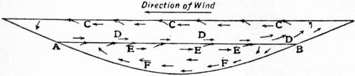
Current systems in a loch induced by wind at the surface. (After Wedderburn.)
AB, Discontinuity layer. C, Surface current. D, Primary return current. E, Secondary surface current. F, Secondary return current.
Another effect of the separation of the loch into two compartments by the surface of discontinuity is to render possible the temperature-seiche. The surface-current produced by the wind transfers a large quantity of warm water to the lee end of the loch, with the result that the surface of discontinuity is deeper at the lee than at the windward end. When the wind ceases, a temperature-seiche is started, just as an ordinary seiche is started in a basin of water which has been tilted. This temperature-seiche has been studied experimentally and rendered visible by superimposing a layer of paraffin on a layer of water.
Wedderburn estimates the quantity of heat that enters Loch Ness and is given out again during the year to be approximately sufficient to raise about 30,000 million gallons of water from freezing-point to boiling-point. Lakes thus modify the climate of the region in which they occur, both by increasing its humidity and by decreasing its range of temperature. They cool and moisten the atmosphere by evaporation during summer, and when they freeze in winter a vast amount of latent heat is liberated, and moderates the fall of temperature.
Lakes act as reservoirs for water, and so tend to restrain floods, and to promote regularity of flow. They become sources of mechanical power, and as their waters are purified by allowing the sediment which enters them to settle, they become valuable sources of water-supply for towns and cities. In temperate regions small and shallow lakes are likely to freeze all over in winter, but deep lakes in similar regions do not generally freeze, owing to the fact that the low temperature of the air does not continue long enough to cool down the entire body of water to the maximum density point. Deep lakes are thus the best sources of water-supply for cities, for in summer they supply relatively cool water and in winter relatively warm water. Besides, the number of organisms in deep lakes is less than in small shallow lakes, in which there is a much higher temperature in summer, and consequently much greater organic growth. The deposits, which are formed along the shores and on the floors of lakes, depend on the geological structure and nature of the adjacent shores.
Biology.—Compared with the waters of the ocean those of lakes may safely be said to contain relatively few animals and plants. Whole groups of organisms—the Echinoderms, for instance—are unrepresented. In the oceans there is a much greater uniformity in the physical and chemical conditions than obtains in lakes. In lakes the temperature varies widely. To underground lakes light does not penetrate, and in these some of the organisms may be blind, for example, the blind crayfish (Cambarus pellucidus) and the blind fish (Amblyopsis spelaeus) of the Kentucky caves. The majority of lakes are fresh, while some are so salt that no organisms have been found in them. The peaty matter in other lakes is so abundant that light does not penetrate to any great depth, and the humic acids in solution prevent the development of some species. Indeed, every lake has an individuality of its own, depending upon climate, size, nature of the bottom, chemical composition and connexion with other lakes. While the ocean contains many families and genera not represented in lakes, almost every genus in lakes is represented in the ocean.
The vertebrates, insects and flowering plants inhabiting lakes vary much according to latitude, and are comparatively well known to zoologists and botanists. The micro-fauna and flora have only recently been studied in detail, and we cannot yet be said to know much about tropical lakes in this respect. Mr James Murray, who has studied the Scottish lakes, records in over 400 Scottish lochs 724 species (the fauna including 447 species, all invertebrates, and the flora comprising 277 species) belonging to the following groups; the list must not be regarded as in any way complete:—
Fauna. Flora.
Mollusca 7 species Phanerogamia 65 species
Hydrachnida 17 ” Equisetaceae 1 ”
Tardigrada 30 ” Selaginellaceae 1 ”
Insecta 7 ” Characeae 6 ”
Crustacea 78 ” Musci 18 ”
Bryozoa 7 ” Hepaticae 2 ”
Worms 25 ” Florideae 2 ”
Rotifera 181 ” Chlorophyceae 142 ”
Gastrotricha 2 ” Bacillariaceae 26 ”
Coelenterata 1 ” Myxophyceae 10 ”
Porifera 1 ” Peridiniaceae 4 ”
Protozoa 91 ”
———— ————
447 ” 277 ”
These organisms are found along the shores, in the deep waters, and in the surface waters of the lakes.
The littoral region is the most populous part of lakes; the existence of a rooted vegetation is only possible there, and this in turn supports a rich littoral fauna. The greater heat of the water along the margins also favours growth. The great majority of the species in Scottish lochs are met with in this region. Insect larvae of many kinds are found under stones or among weeds. Most of the Cladocera, and the Copepoda of the genus Cyclops, and the Harpacticidae are only found in this region. Water-mites, nearly all the Rotifers, Gastrotricha, Tardigrada and Molluscs are found here, and Rhizopods are abundant. A large number of the littoral species in Loch Ness extends down to a depth of about 300 ft.
The abyssal region, in Scottish lochs, lies, as a rule, deeper than 300 ft., and in this deep region a well-marked association of animals appears in the muds on the bottom, but none of them are peculiar to it: they all extend into the littoral zone, from which they were originally derived. In Loch Ness the following sparse population was recorded:—
1 Mollusc: Pisidium pusillum (Gmel).
3 Crustacea: Cyclops viridis, Jurine.
Candona candida (Müll).
Cypria ophthalmica, Jurine.
3 Worms: Stylodrilus gabreteae, Vejd.
Oligochaete, not determined.
Automolos morgiensis (Du Plessis).
1 Insect: Chironomus (larva).
Infusoria: Several, ectoparasites on Pisidium and Cyclops, not determined.
In addition, the following were found casually at great depths in Loch Ness: Hydra, Limnaea peregra, Proales daphnicola and Lynceus affinis.
The pelagic region of the Scottish lakes is occupied by numerous microscopic organisms, belonging to the Zooplankton and Phytoplankton. Of the former group 30 species belonging to the Crustacea, Rotifera and Protozoa were recorded in Loch Ness. Belonging to the second group 150 species were recorded, of which 120 were Desmids. Some of these species of plankton organisms are almost universal in the Scottish lochs, while others are quite local. Some of the species occur all the year through, while others have only been recorded in summer or in winter. The great development of Algae in the surface waters, called “flowering of the water” (Wasserblüthe), was observed in August in Loch Lomond; a distinct “flowering,” due to Chlorophyceae, has been observed in shallow lochs as early as July. It is most common in August and September, but has also been observed in winter.
The plankton animals which are dominant or common, both over Scotland and the rest of Europe, are:—
Diaptomus gracilis. Daphnia kyalina. Diaphanosoma brachyurum. Leptodora kindtii. Conochilus unicornis. Asplanchna priodonta. Polyarthra platyptera. Anuraea cochlearis. Notholca longispina. Ceratium hirundinella. Asterionella.
All of these, according to Dr Lund, belong to the general plankton association of the European plain, or are even cosmopolitan.
The Scottish plankton on the whole differs from the plankton of the central European plateau, and from the cosmopolitan fresh-water plankton, in the extraordinary richness of the Phytoplankton in species of Desmids, in the conspicuous arctic element among the Crustacea, in the absence or comparative rarity of the species commonest in the general European plankton. Another peculiarity is the local distribution of some of the Crustacea and many of the Desmids.
The derivation of the whole lacustrine population of the Scottish lochs does not seem to present any difficulty. The abyssal forms have been traced to the littoral zone without any perceptible modifications. The plankton organisms are a mingling of European and arctic species. The cosmopolitan species may enter the lochs by ordinary migration. It is probable that if the whole plankton could be annihilated, it would be replaced by ordinary migration within a few years. The eggs and spores of many species can be dried up without injury, and may be carried through the air as dust from one lake to another; others, which would not bear desiccation, might be carried in mud adhering to the feet of aquatic birds and in various other ways. The arctic species may be survivors from a period when arctic conditions prevailed over a great part of Europe. What are known as “relicts” of a marine fauna have not been found in the Scottish fresh-water lochs.
It is somewhat remarkable that none of the organisms living in fresh-water lochs has been observed to exhibit the phenomenon of phosphorescence, although similar organisms in the salt-water lochs a few miles distant exhibit brilliant phosphorescence. At similar depths in the sea-lochs there is usually a great abundance of life when compared with that found in fresh-water lochs.
Length, Depth, Area and Volume of Lakes.—In the following table will be found the length, depth, area and volume of some of the principal lakes of the world.1 Sir John Murray estimates The volume of water in the 560 Scottish lochs recently surveyed at 7 cub. m., and the approximate volume of water in all the lakes of the world at about 2000 cub. m., so that this last number is but a small fraction of the volume of the ocean, which he previously estimated at 324 million cub. m. It may be recalled that the total rainfall on the land of the globe is estimated at 29,350 cub. m., and the total discharge from the rivers of the globe at 6524 cub. m.
British Lakes
Length in Miles. Depth in Feet. Area in sq. m. Volume in million cub. ft.
I. England— Max. Mean.
Windermere 10.50 219 78.5 5.69 12,250
Ullswater 7.35 205 83 3.44 7,870
Wastwater 3.00 258 134.5 1.12 4,128
Coniston Water 5.41 184 79 1.89 4,000
Crummock Water 2.50 144 87.5 0.97 2,343
Ennerdale Water 2.40 148 62 1.12 1,978
Bassenthwaite Water 3.83 70 18 2.06 1,023
Derwentwater 2.87 72 18 2.06 1,010
Haweswater 2.33 103 39.5 0.54 589
Buttermere 1.26 94 54.5 0.36 537
II. Wales—
Llyn Cawlyd 1.62 222 109.1 0.18 941
Llyn Cwellyn 1.20 122 74.1 0.35 713
Llyn Padarn 2.00 94 52.4 0.43 632
Llyn Llydaw 1.11 190 77.4 0.19 409
Llyn Peris 1.10 114 63.9 0.19 344
Llyn Dulyn 0.31 189 104.2 0.05 156
III. Scotland—
Ness 24.23 754 433.02 21.78 263,162
Lomond 22.64 623 121.29 27.45 92,805
Morar 11.68 1017 284.00 10.30 81,482
Tay 14.55 508 199.08 10.19 56,550
Awe 25.47 307 104.95 14.85 43,451
Maree 13.46 367 125.30 11.03 38,539
Lochy 9.78 531 228.95 5.91 37,726
Rannoch 9.70 440 167.46 7.37 34,387
Shiel 17.40 420 132.73 7.56 27,986
Arkaig 12.00 359 152.71 6.24 26,573
Earn 6.46 287 137.83 3.91 14,421
Treig 5.10 436 207.37 2.41 13,907
Shin 17.22 162 51.04 8.70 12,380
Fannich 6.92 282 108.76 3.60 10,920
Assynt 6.36 282 101.10 3.10 8,731
Quoich 6.95 281 104.60 2.86 8,345
Glass 4.03 365 159.07 1.86 8,265
Fionn (Carnmore) 5.76 144 57.79 3.52 5,667
Laggan 7.04 174 67.68 2.97 5,601
Loyal 4.46 217 65.21 2.55 4,628
IV. Ireland—
Neagh 17 102 40 153 161,000
Erne (Lower) 24 226 43 43 62,000
Erne (Upper) 13 89 10 15 5,000
Corrib 27 152 30 68 59,000
Mask 10 191 52 35 55,000
Derg 24 119 30 49 47,000
European Continental Lakes
Length in Miles. Depth in Feet. Area in sq. m. Volume in million cub. ft.
Max. Mean.
Ladoga 125 732 300 7000 43,200,000
Onega 145 740 200 3800 21,000,000
Vener 93 292 108 2149 6,357,000
Geneva 45 1015 506 225 3,175,000
Vetter 68 413 128 733 2,543,000
Mjösen 57 1483 .. 139 2,882,000
Garda 38 1124 446 143 1,766,000
Constance 42 827 295 208 1,711,000
Ochrida 19 942 479 105 1,391,000
Maggiore 42 1220 574 82 1,310,000
Como 30 1345 513 56 794,000
Hornafvan 7 1391 253 93 777,000
African Lakes
Length in Miles. Depth in Feet. Area in sq. m. Volume in million cub. ft.
Max. Mean.
Victoria Nyanza 200 240 .. 26,200 5,800,000
Nyasa 350 2580 .. 14,200 396,000,000
Tanganyika 420 2100 .. 12,700 283,000,000
Asiatic Lakes
Length in Miles. Depth in Feet. Area in sq. m. Volume in million cub. ft.
Max. Mean.
Aral 265 222 52 24,400 43,600,000
Baikal 330 5413 .. 11,580 274,000,000
Balkash 323 33 .. 7,000 4,880,000
Urmia 80 50 15 1,750 732,000
American Lakes
Length in Miles. Depth in Feet. Area in sq. m. Volume in million cub. ft.
Max. Mean.
Superior 412 1008 475 31,200 413,000,000
Huron 263 730 250 23,800 166,000,000
Michigan 335 870 325 22,450 203,000,000
Erie 240 210 70 9,960 19,500,000
Ontario 190 738 300 7,240 61,000,000
Titicaca 120 924 347 3,200 30,900,000
New Zealand Lakes
Length in Miles. Depth in Feet. Area in sq. m. Volume in million cub. ft.
Max. Mean.
Taupo 25 534 367 238.0 2,435,000
Wakatipu 49 1242 707 112.3 2,205,000
Manapouri 19 1458 328 56.0 512,000
Rotorua 7.5 120 39 31.6 34,000
Waikarimoana 7.25 846 397 14.7 166,000
Wairaumoana 5.25 375 175 6.1 30,000
Rotoiti 10.7 230 69 14.2 27,000
Authorities.—F. A. Forel, “Handbuch der Seenkunde: allgemeine Limnologie,” Bibliothek geogr. Handbücher (Stuttgart, 1901), Le Léman, monographie limnologique (3 vols., Lausanne, 1892-1901); A. Delebecque, Les Lacs français, text and plates (Paris, 1898); H. R. Mill, “Bathymetrical Survey of the English Lakes,” Geogr. Journ. vol. vi. pp. 46 and 135 (1895); Jehu, “Bathymetrical and Geological Study of the Lakes of Snowdonia,” Trans. Roy. Soc. Edin. vol. xl. p. 419 (1902); Sir John Murray and Laurence Pullar, “Bathymetrical Survey of the Freshwater Lochs of Scotland,” Geogr. Journ. (1900 to 1908, re-issued in six volumes, Edinburgh, 1910); W. Halbfass, “Die Morphometrie der europäischen Seen,” Zeitschr. Gesell. Erdkunde Berlin (Jahrg. 1903, p. 592; 1904, p. 204); I. C. Russell, Lakes of North America (Boston and London, 1895); O. Zacharias, “Forschungsberichte aus der biologischen Station zu Plön” (Stuttgart); F. E. Bourcart, Les Lacs alpins suisses: étude chimique et physique (Geneva, 1906); G. P. Magrini, Limnologia (Milan, 1907).
(J. Mu.)
1 Divergence between certain of these figures and those quoted elsewhere in this work may be accounted for by the slightly different results arrived at by various authorities.
LAKE CHARLES, a city of Louisiana, U.S.A., capital of Calcasieu Parish, 30 m. from the Gulf of Mexico and about 218 m. (by rail) W. of New Orleans. Pop. (1889) 838, (1890) 3442, (1900) 6680 (2407 negroes); (1910) 11,449. It is served by the Louisiana & Texas (Southern Pacific System), the St Louis, Watkins & Gulf, the Louisiana & Pacific and the Kansas City Southern railways. The city is charmingly situated on the shore of Lake Charles, and on the Calcasieu river, which with some dredging can be made navigable for large vessels for 132 m. from the Gulf. It is a winter resort. Among the principal buildings are a Carnegie library, the city hall, the Government building, the court house, St Patrick’s sanatorium, the masonic temple and the Elks’ club. Lake Charles is in the prairie region of southern Louisiana, to the N. of which, covering a large part of the state, are magnificent forests of long-leaf pine, and lesser lowland growths of oak, ash, magnolia, cypress and other valuable timber. The Watkins railway extending to the N.E. and the Kansas City Southern extending to the N.W. have opened up the very best of the forest. The country to the S. and W. is largely given over to rice culture. Lake Charles is the chief centre of lumber manufacture in the state, and has rice mills, car shops and an important trade in wool. Ten miles W. are sulphur mines (product in 1907 about 362,000 tons), which with those of Sicily produce a large part of the total product of the world. Jennings, about 34 m. to the E., is the centre of oil fields, once very productive but now of diminishing importance. Welsh, 23 m. E., is the centre of a newer field; and others lie to the N. Lake Charles was settled about 1852, largely by people from Iowa and neighbouring states, was incorporated as a town in 1857 under the name of Charleston and again in 1867 under its present name, and was chartered as a city in 1886. The city suffered severely by fire in April 1910.
LAKE CITY, a town and the county-seat of Columbia county, Florida, U.S.A., 59 m. by rail W. by S. of Jacksonville. Pop. (1900) 4013, of whom 2159 were negroes; (1905) 6509; (1910) 5032. Lake City is served by the Atlantic Coast Line, the Seaboard Air Line and the Georgia Southern & Florida railways. There are ten small lakes in the neighbourhood, and the town is a winter and health resort. It is the seat of Columbia College (Baptist, 1907); the Florida Agricultural College was opened here in 1883, became the university of Florida in 1903, and in 1905 was abolished by the Buckman Law. Vegetables and fruits grown for the northern markets, sea-island cotton and tobacco are important products of the surrounding country, and Lake City has some trade in cotton, lumber, phosphates and turpentine. The town was first settled about 1826 as Alligator; it was incorporated in 1854; adopted the present name in 1859; and in 1901, with an enlarged area, was re-incorporated.
LAKE DISTRICT, in England, a district containing all the principal English lakes, and variously termed the Lake Country, Lakeland and “the Lakes.” It falls within the north-western counties of Cumberland, Westmorland and Lancashire (Furness district), about one-half being within the first of these. Although celebrated far outside the confines of Great Britain as a district of remarkable and strongly individual physical beauty, its area is only some 700 sq. m., a circle with radius of 15 m. from the central point covering practically the whole. Within this circle, besides the largest lake, Windermere, is the highest point in England, Scafell Pike; yet Windermere is but 10½ m. in length, and covers an area of 5.69 sq. m., while Scafell Pike is only 3210 ft. in height. But the lakes show a wonderful variety of character, from open expanse and steep rock-bound shores to picturesque island-groups and soft wooded banks; while the mountains have always a remarkable dignity, less from the profile of their summits than from the bold sweeping lines of their flanks, unbroken by vegetation, and often culminating in sheer cliffs or crags. At their feet, the flat green valley floors of the higher elevations give place in the lower parts to lovely woods. The streams are swift and clear, and numerous small waterfalls are characteristic of the district. To the north, west and south, a flat coastal belt, bordering the Irish Sea, with its inlets Morecambe Bay and Solway Firth, and broadest in the north, marks off the Lake District, while to the east the valleys of the Eden and the Lune divide it from the Pennine mountain system. Geologically, too, it is individual. Its centre is of volcanic rocks, complex in character, while the Coal-measures and New Red Sandstone appear round the edges. The district as a whole is grooved by a main depression, running from north to south along the valleys of St John, Thirlmere, Grasmere and Windermere, surmounting a pass (Dunmail Raise) of only 783 ft.; while a secondary depression, in the same direction, runs along Derwentwater, Borrowdale, Wasdale and Wastwater, but here Sty Head Pass, between Borrowdale and Wasdale, rises to 1600 ft. The centre of the 15-m. radius lies on the lesser heights between Langstrath and Dunmail Raise, which may, however, be the crown of an ancient dome of rocks, “the dissected skeleton of which, worn by the warfare of air and rain and ice, now alone remains” (Dr H. R. Mill, “Bathymetrical Survey of the English Lakes,” Geographical Journal, vi. 48). The principal features of the district may be indicated by following this circle round from north, by west, south and east.
The river Derwent (q.v.), rising in the tarns and “gills” or “ghylls” (small streams running in deeply-grooved clefts) north of Sty Head Pass and the Scafell mass flows north through the wooded Borrowdale and forms Derwentwater and Bassenthwaite. These two lakes are in a class apart from all the rest, being broader for their length, and quite shallow (about 18 ft. average and 70 ft. maximum), as distinct from the long, narrow and deep troughs occupied by the other chief lakes, which average from 40 to 135 ft. deep. Derwentwater (q.v.), studded with many islands, is perhaps the most beautiful of all. Borrowdale is joined on the east by the bare wild dale of Langstrath, and the Greta joins the Derwent immediately below Derwentwater; the town of Keswick lying near the junction. Derwentwater and Bassenthwaite occupy a single depression, a flat alluvial plain separating them. From Seatoller in Borrowdale a road traverses Honister Pass (1100 ft.), whence it descends westward, beneath the majestic Honister Crags, where green slate is quarried, into the valley containing Buttermere (94 ft. max. depth) and Crummock Water (144 ft.), drained by the Cocker. Between this and the Derwent valley the principal height is Grasmoor (2791 ft.); southward a steep narrow ridge (High Style, 2643) divides it from Ennerdale, containing Ennerdale Water (148 ft. max. depth), which is fed by the Liza and drained by the Ehen. A splendid range separates this dale from Wasdale and its tributary Mosedale, including Great Gable (2949 ft.), Pillar (2927), with the precipitous Pillar Rock on the Ennerdale flank and Steeple (2746). Wasdale Head, between Gable and the Scafell range, is peculiarly grand, with dark grey screes and black crags frowning above its narrow bottom. On this side of Gable is the fine detached rock, Napes Needle. Wastwater, 3 m. in length, is the deepest lake of all (258 ft.), its floor, like those of Windermere and Ullswater, sinking below sea-level. Its east shore consists of a great range of screes. East of Wasdale lies the range of Scafell (q.v.), its chief points being Scafell (3162 ft.), Scafell Pike (3210), Lingmell (2649) and Great End (2984), while the line is continued over Esk Hause Pass (2490) along a fine line of heights (Bow Fell, 2960; Crinkle Crags, 2816), to embrace the head of Eskdale. The line then descends to Wrynose Pass (1270 ft.), from which the Duddon runs south through a vale of peculiar richness in its lower parts; while the range continues south to culminate in the Old Man of Coniston (2633) with the splendid Dow Crags above Goats Water. The pleasant vale of Yewdale drains south to Coniston Lake (5½ m. long, 184 ft. max. depth), east of which a lower, well-wooded tract, containing two beautiful lesser lakes, Tarn Hows and Esthwaite Water, extends to Windermere (q.v.). This lake collects waters by the Brathay from Langdale, the head of which, between Bow Fell and Langdale Pikes (2401 ft.), is very fine; and by the Rothay from Dunmail Raise and the small lakes of Grasmere and Rydal Water, embowered in woods. East of the Rothay valley and Thirlmere lies the mountain mass including Helvellyn (3118 ft.), Fairfield (2863) and other points, with magnificent crags at several places on the eastern side towards Grisedale and Patterdale. These dales drain to Ullswater (205 ft. max., second to Windermere in area), and so north-east to the Eden. To the east and south-east lies the ridge named High Street (2663 ft.), from the Roman road still traceable from south to north along its summit, and sloping east again to the sequestered Hawes Water (103 ft. max.), a curiously shaped lake nearly divided by the delta of the Measand Beck. There remains the Thirlmere valley. Thirlmere itself was raised in level, and adapted by means of a dam at the north end, as a reservoir for the water-supply of Manchester in 1890-1894. It drains north by St John’s Vale into the Greta, north of which again rises a mountain-group of which the chief summits are Saddleback or Blencathra (2847 ft.) and the graceful peak of Skiddaw (3054). The most noteworthy waterfalls are—Scale Force (Dano-Norwegian fors, foss), beside Crummock, Lodore near Derwentwater, Dungeon Gill Force, beside Langdale, Dalegarth Force in Eskdale, Aira near Ullswater, sung by Wordsworth, Stock Gill Force and Rydal Falls near Ambleside.
The principal centres in the Lake District are Keswick (Derwentwater), Ambleside, Bowness, Windermere and Lakeside (Windermere), Coniston and Boot (Eskdale), all of which, except Ambleside and Bowness (which nearly joins Windermere) are accessible by rail. The considerable village of Grasmere lies beautifully at the head of the lake of that name; and above Esthwaite is the small town of Hawkshead, with an ancient church, and picturesque houses curiously built on the hill-slope and sometimes spanning the streets. There are regular steamer services on Windermere and Ullswater. Coaches and cars traverse the main roads during the summer, but many of the finest dales and passes are accessible only on foot or by ponies. All the mountains offer easy routes to pedestrians, but some of them, as Scafell, Pillar, Gable (Napes Needle), Pavey Ark above Langdale and Dow Crags near Coniston, also afford ascents for experienced climbers.
This mountainous district, having the sea to the west, records an unusually heavy rainfall. Near Seathwaite, below Styhead Pass, the largest annual rainfall in the British Isles is recorded, the average (1870-1899) being 133.53 in., while 173.7 was measured in 1903 and 243.98 in. in 1872. At Keswick the annual mean is 60.02, at Grasmere about 80 ins. The months of maximum rainfall at Seathwaite are November, December and January and September.
Fish taken in the lakes include perch, pike, char and trout in Windermere, Ennerdale, Bassenthwaite, Derwentwater, &c., and the gwyniad or fresh-water herring in Ullswater. The industries of the Lake District include slate quarrying and some lead and zinc mining, and weaving, bobbin-making and pencil-making.
Setting aside London and Edinburgh, no locality in the British Isles is so intimately associated with the history of English literature as the Lake District. In point of time the poet whose name is first connected with the region is Gray, who wrote a journal of his tour in 1769. But it was Wordsworth, a native of Cumberland, born on the outskirts of the Lake District itself, who really made it a Mecca for lovers of English poetry. Out of his long life of eighty years, sixty were spent amid its lakes and mountains, first as a schoolboy at Hawkshead, and afterwards as a resident at Grasmere (1799-1813) and Rydal Mount (1813-1850). In the churchyard of Grasmere the poet and his wife lie buried; and very near to them are the remains of Hartley Coleridge (son of the poet), who himself lived many years at Keswick, Ambleside and Grasmere. Southey, the friend of Wordsworth, was a resident of Keswick for forty years (1803-1843), and was buried in Crosthwaite churchyard. Samuel Taylor Coleridge lived some time at Keswick, and also with the Wordsworths at Grasmere. From 1807 to 1815 Christopher North (John Wilson) was settled at Windermere. De Quincey spent the greater part of the years 1809 to 1828 at Grasmere, in the first cottage which Wordsworth had inhabited. Ambleside, or its environs, was also the place of residence of Dr Arnold (of Rugby), who spent there the vacations of the last ten years of his life; and of Harriet Martineau, who built herself a house there in 1845. At Keswick Mrs Lynn Linton was born in 1822. Brantwood, a house beside Coniston Lake, was the home of Ruskin during the last years of his life. In addition to these residents or natives of the locality, Shelley, Scott, Nathaniel Hawthorne, Clough, Crabb Robinson, Carlyle, Keats, Tennyson, Matthew Arnold, Mrs Hemans, Gerald Massey and others of less reputation made longer or shorter visits, or were bound by ties of friendship with the poets already mentioned. The Vale of St John, near Keswick, recalls Scott’s Bridal of Triermain. But there is a deeper connexion than this between the Lake District and English letters. German literature tells of several literary schools, or groups of writers animated by the same ideas, and working in the spirit of the same principles and by the same poetic methods. The most notable instance—indeed it is almost the only instance—of the kind in English literature is the Lake School of Poets. Of this school the acknowledged head and founder was Wordsworth, and the tenets it professed are those laid down by the poet himself in the famous preface to the edition of The Lyrical Ballads which he published in 1800. Wordsworth’s theories of poetry—the objects best suited for poetic treatment, the characteristics of such treatment and the choice of diction suitable for the purpose—may be said to have grown out of the soil and substance of the lakes and mountains, and out of the homely lives of the people, of Cumberland and Westmoreland.
See Cumberland, Lancashire, Westmorland. The following is a selection from the literature of the subject: Harriet Martineau, The English Lakes (Windermere, 1858); Mrs Lynn Linton, The Lake Country (London, 1864); E. Waugh, Rambles in the Lake Country (1861) and In the Lake Country (1880); W. Knight, Through the Wordsworth Country (London, 1890); H. D. Rawnsley, Literary Associations of the English Lakes (2 vols., Glasgow, 1894) and Life and Nature of the English Lakes (Glasgow, 1899); Stopford Brooke, Dove Cottage, Wordsworth’s Home from 1800 to 1808; A. G. Bradley, The Lake District, its Highways and Byeways (London, 1901); Sir John Harwood, History of the Thirlmere Water Scheme (1895); for mountain-climbing, Col. J. Brown, Mountain Ascents in Westmorland and Cumberland (London, 1888); Haskett-Smith, Climbing in the British Isles, part, i.; Owen G. Jones, Rock-climbing in the English Lake District, 2nd ed. by W. M. Crook (Keswick, 1900).
LAKE DWELLINGS, the term employed in archaeology for habitations constructed, not on the dry land, but within the margins of lakes or creeks at some distance from the shore.
The villages of the Guajiros in the Gulf of Maracaibo are described by Goering as composed of houses with low sloping roofs perched on lofty piles and connected with each other by bridges of planks. Each house consisted of two apartments; the floor was formed of split stems of trees set close together and covered with mats; they were reached from the shore by dug-out canoes poled over the shallow waters, and a notched tree trunk served as a ladder. The custom is also common in the estuaries of the Orinoco and Amazon. A similar system prevails in New Guinea. Dumont d’Urville describes four such villages in the Bay of Dorei, containing from eight to fifteen blocks or clusters of houses, each block separately built on piles, and consisting of a row of distinct dwellings. C. D. Cameron describes three villages thus built on piles in Lake Mohrya, or Moria, in Central Africa, the motive here being to prevent surprise by bands of slave-catchers. Similar constructions have been described by travellers, among the Dyaks of Borneo, in Celebes, in the Caroline Islands, on the Gold Coast of Africa, and in other places.
Hippocrates, writing in the 5th century B.C., says of the people of the Phasis that their country is hot and marshy and subject to frequent inundations, and that they live in houses of timber and reeds constructed in the midst of the waters, and use boats of a single tree trunk. Herodotus, writing also in the 5th century B.C., describes the people of Lake Prasias as living in houses constructed on platforms supported on piles in the middle of the lake, which are approached from the land by a single narrow bridge. Abulfeda the geographer, writing in the 13th century, notices the fact that part of the Apamaean Lake was inhabited by Christian fishermen who lived on the lake in wooden huts built on piles, and Sir John Lubbock (Lord Avebury) mentions that the Rumelian fishermen on Lake Prasias “still inhabit wooden cottages built over the water, as in the time of Herodotus.”
The records of the wars in Ireland in the 16th century show that the petty chieftains of that time had their defensive strongholds constructed in the “freshwater lochs” of the country, and there is record evidence of a similar system in the western parts of Scotland. The archaeological researches of the past fifty years have shown that such artificial constructions in lakes were used as defensive dwellings by the Celtic people from an early period to medieval times (see Crannog). Similar researches have also established the fact that in prehistoric times nearly all the lakes of Switzerland, and many in the adjoining countries—in Savoy and the north of Italy, in Austria and Hungary and in Mecklenburg and Pomerania—were peopled, so to speak, by lake-dwelling communities, living in villages constructed on platforms supported by piles at varying distances from the shores. The principal groups are those in the Lakes of Bourget, Geneva, Neuchâtel, Bienne, Zürich and Constance lying to the north of the Alps, and in the Lakes Maggiore, Varese, Iseo and Garda lying to the south of that mountain range. Many smaller lakes, however, contain them, and they are also found in peat moors on the sites of ancient lakes now drained or silted up, as at Laibach in Carniola. In some of the larger lakes the number of settlements has been very great. Fifty are enumerated in the Lake of Neuchâtel, thirty-two in the Lake of Constance, twenty-four in the Lake of Geneva, and twenty in the Lake of Bienne. The site of the lake dwelling of Wangen, in the Untersee, Lake of Constance, forms a parallelogram more than 700 paces in length by about 120 paces in breadth. The settlement at Morges, one of the largest in the Lake of Geneva, is 1200 ft. long by 150 ft. in breadth. The settlement of Sutz, one of the largest in the Lake of Bienne, extends over six acres, and was connected with the shore by a gangway nearly 100 yds. long and about 40 ft. wide.
The substructure which supported the platforms on which the dwellings were placed was most frequently of piles driven into the bottom of the lake. Less frequently it consisted of a stack of brushwood or fascines built up from the bottom and strengthened by stakes penetrating the mass so as to keep it from spreading. When piles were used they were the rough stems of trees of a length proportioned to the depth of the water, sharpened sometimes by fire and at other times chopped to a point by hatchets. On their level tops the beams supporting the platforms were laid and fastened by wooden pins, or inserted in mortices cut in the heads of the piles. In some cases the whole construction was further steadied and strengthened by cross beams, notched into the piles below the supports of the platform. The platform itself was usually composed of rough layers of unbarked stems, but occasionally it was formed of boards split from larger stems. When the mud was too soft to afford foothold for the piles they were mortised into a framework of tree trunks placed horizontally on the bottom of the lake. On the other hand, when the bottom was rocky so that the piles could not be driven, they were steadied at their bases by being enveloped in a mound of loose stones, in the manner in which the foundations of piers and breakwaters are now constructed. In cases where piles have not been used, as at Niederwil and Wauwyl, the substructure is a mass of fascines or faggots laid parallel and crosswise upon one another with intervening layers of brushwood or of clay and gravel, a few piles here and there being fixed throughout the mass to serve as guides or stays. At Niederwil the platform was formed of split boards, many of which were 2 ft. broad and 2 or 3 in. in thickness.
On these substructures were the huts composing the settlement; for the peculiarity of these lake dwellings is that they were pile villages, or clusters of huts occupying a common platform. The huts themselves were quadrilateral in form. The size of each dwelling is in some cases marked by boards resting edgeways on the platform, like the skirting boards over the flooring of the rooms in a modern house. The walls, which were supported by posts, or by piles of greater length, were formed of wattle-work, coated with clay. The floors were of clay, and in each floor there was a hearth constructed of flat slabs of stone. The roofs were thatched with bark, straw, reeds or rushes. As the superstructures are mostly gone, there is no evidence as to the position and form of the doorways, or the size, number and position of the windows, if there were any. In one case, at Schussenried, the house, which was of an oblong quadrangular form, about 33 by 23 ft., was divided into two rooms by a partition. The outer room, which was the smaller of the two, was entered by a doorway 3 ft. in width facing the south. The access to the inner room was by a similar door through the partition. The walls were formed of split tree-trunks set upright and plastered with clay; and the flooring of similar timbers bedded in clay. In other cases the remains of the gangways or bridges connecting the settlements with the shore have been discovered, but often the village appears to have been accessible only by canoes. Several of these single-tree canoes have been found, one of which is 43 ft. in length and 4 ft. 4 in. in its greatest width. It is impossible to estimate with any degree of certainty the number of separate dwellings of which any of these villages may have consisted, but at Niederwil they stood almost contiguously on the platform, the space between them not exceeding 3 ft. in width. The size of the huts also varied considerably. At Niederwil they were 20 ft. long and 12 ft. wide, while at Robenhausen they were about 27 ft. long by about 22 ft. wide.
The character of the relics shows that in some cases the settlements have been the dwellings of a people using no materials but stone, bone and wood for their implements, ornaments and weapons; in others, of a people using bronze as well as stone and bone; and in others again the occasional use of iron is disclosed. But, though the character of the relics is thus changed, there is no corresponding change in the construction and arrangements of the dwellings. The settlement in the Lake of Moosseedorf, near Bern, affords the most perfect example of a lake dwelling of the Stone age. It was a parallelogram 70 ft. long by 50 ft. wide, supported on piles, and having a gangway built on faggots connecting it with the land. The superstructure had been destroyed by fire. The implements found in the relic bed under it were axe-heads of stone, with their haftings of stag’s horn and wood; a flint saw, set in a handle of fir wood and fastened with asphalt; flint flakes and arrow-heads; harpoons of stag’s horn with barbs; awls, needles, chisels, fish-hooks and other implements of bone; a comb of yew wood 5 in. long; and a skate made out of the leg bone of a horse. The pottery consisted chiefly of roughly-made vessels, some of which were of large size, others had holes under the rims for suspension, and many were covered with soot, the result of their use as culinary vessels. Burnt wheat, barley and linseed, with many varieties of seeds and fruits, were plentifully mingled with the bones of the stag, the ox, the swine, the sheep and the goat, representing the ordinary food of the inhabitants, while remains of the beaver, the fox, the hare, the dog, the bear, the horse, the elk and the bison were also found.
The settlement of Robenhausen, in the moor which was formerly the bed of the ancient Lake of Pfäffikon, seems to have continued in occupation after the introduction of bronze. The site covers nearly 3 acres, and is estimated to have contained 100,000 piles. In some parts three distinct successions of inhabited platforms have been traced. The first had been destroyed by fire. It is represented at the bottom of the lake by a layer of charcoal mixed with implements of stone and bone and other relics highly carbonized. The second is represented above the bottom by a series of piles with burnt heads, and in the bottom by a layer of charcoal mixed with corn, apples, cloth, bones, pottery and implements of stone and bone, separated from the first layer of charcoal by 3 ft. of peaty sediment intermixed with relics of the occupation of the platform. The piles of the third settlement do not reach down to the shell marl, but are fixed in the layers representing the first and second settlements. They are formed of split oak trunks, while those of the two first settlements are round stems chiefly of soft wood. The huts of this last settlement appear to have had cattle stalls between them, the droppings and litter forming heaps at the lake bottom. The bones of the animals consumed as food at this station were found in such numbers that 5 tons were collected in the construction of a watercourse which crossed the site. Among the wooden objects recovered from the relic beds were tubs, plates, ladles and spoons, a flail for threshing corn, a last for stretching shoes of hide, celt handles, clubs, long-bows of yew, floats and implements of fishing and a dug-out canoe 12 ft. long. No spindle-whorls were found, but there were many varieties of cloth, platted and woven, bundles of yarn and balls of string. Among the tools of bone and stag’s horn were awls, needles, harpoons, scraping tools and haftings for stone axe-heads. The implements of stone were chiefly axe-heads and arrow-heads. Of clay and earthenware there were many varieties of domestic dishes, cups and pipkins, and crucibles or melting pots made of clay and horse dung and still retaining the drossy coating of the melted bronze.
The settlement of Auvernier in the Lake of Neuchâtel is one of the richest and most considerable stations of the Bronze age. It has yielded four bronze swords, ten socketed spear-heads, forty celts or axe-heads and sickles, fifty knives, twenty socketed chisels, four hammers and an anvil, sixty rings for the arms and legs, several highly ornate torques or twisted neck rings, and upwards of two hundred hair pins of various sizes up to 16 in. in length, some having spherical heads in which plates of gold were set. Moulds for sickles, lance-heads and bracelets were found cut in stone or made in baked clay. From four to five hundred vessels of pottery finely made and elegantly shaped are indicated by the fragments recovered from the relic bed. The Lac de Bourget, in Savoy, has eight settlements, all of the Bronze age. These have yielded upwards of 4000 implements, weapons and ornaments of bronze, among which were a large proportion of moulds and founders’ materials. A few stone implements suggest the transition from stone to bronze; and the occasional occurrence of iron weapons and pottery of Gallo-Roman origin indicates the survival of some of the settlements to Roman times.
The relative antiquity of the earlier settlements of the Stone and Bronze ages is not capable of being deduced from existing evidence. “We may venture to place them,” says Dr F. Keller, “in an age when iron and bronze had been long known, but had not come into our districts in such plenty as to be used for the common purposes of household life, at a time when amber had already taken its place as an ornament and had become an object of traffic.” It is now considered that the people who erected the lake dwellings of Central Europe were also the people who were spread over the mainland. The forms and the ornamentation of the implements and weapons of stone and bronze found in the lake dwellings are the same as those of the implements and weapons in these materials found in the soil of the adjacent regions, and both groups must therefore be ascribed to the industry of one and the same people. Whether dwelling on the land or dwelling in the lake, they have exhibited so many indications of capacity, intelligence, industry and social organization that they cannot be considered as presenting, even in their Stone age, a very low condition of culture or civilization. Their axes were made of tough stones, sawn from the block and ground to the fitting shape. They were fixed by the butt in a socket of stag’s horn, mortised into a handle of wood. Their knives and saws of flint were mounted in wooden handles and fixed with asphalt. They made and used an endless variety of bone tools. Their pottery, though roughly finished, is well made, the vessels often of large size and capable of standing the fire as cooking utensils. For domestic dishes they also made wooden tubs, plates, spoons, ladles and the like. The industries of spinning and weaving were largely practised. They made nets and fishing lines, and used canoes. They practised agriculture, cultivating several varieties of wheat and barley, besides millet and flax. They kept horses, cattle, sheep, goats and swine. Their clothing was partly of linen and partly of woollen fabrics and the skins of their beasts. Their food was nutritious and varied, their dwellings neither unhealthy nor incommodious. They lived in the security and comfort obtained by social organization, and were apparently intelligent, industrious and progressive communities.
There is no indication of an abrupt change from the use of stone to the use of metal such as might have occurred had the knowledge of copper and bronze, and the methods of working them, been introduced through the conquest of the original inhabitants by an alien race of superior culture and civilization. The improved cultural conditions become apparent in the multiplication of the varieties of tools, weapons and ornaments made possible by the more adaptable qualities of the new material; and that the development of the Bronze age culture in the lake dwellings followed the same course as in the surrounding regions where the people dwelt on the dry land is evident from the correspondence of the types of implements, weapons, ornaments and utensils common to both these conditions of life.
Other classes of prehistoric pile-structures akin to the lake dwellings are the Terremare of Italy and the Terpen of Holland. Both of these are settlements of wooden huts erected on piles, not over the water, but on flat land subject to inundations. The terremare (so named from the marly soil of which they are composed) appear as mounds, sometimes of very considerable extent, which when dug into disclose the remains and relic beds of the ancient settlements. They are most abundant in the plains of northern Italy traversed by the Po and its tributaries, though similar constructions have been found in Hungary in the valley of the Theiss. These pile-villages were often surrounded by an earthen rampart within which the huts were erected in more or less regular order. Many of them present evidence of having been more than once destroyed by fire and reconstructed, while others show one or more reconstructions at higher levels on the same site. The contents of the relic beds indicate that they belong for the most part to the age of bronze, although in some cases they may be referred to the latter part of the Stone age. Their inhabitants practised agriculture and kept the common domestic animals, while their tools, weapons and ornaments were mainly of similar character to those of the contemporary lake dwellers of the adjoining regions. Some of the Italian terremare show quadrangular constructions made like the modern log houses, of undressed tree trunks superposed longitudinally and overlapping at the ends, as at Castione in the province of Parma. A similar mode of construction is found in the pile-village on the banks of the Save, near Donja Dolina in Bosnia, described in 1904 by Dr Truhelka. Here the larger houses had platforms in front of them forming terraces at different levels descending towards the river. There was a cemetery adjacent to the village in which both unburnt and cremated interments occurred, the former predominating. From the general character of the relics this settlement appeared to belong to the early Iron age. The Terpen of Holland appear as mounds somewhat similar to those of the terremare, and were also pile structures, on low or marshy lands subject to inundations from the sea. Unlike the terremare and the lake dwellings they do not seem to belong to the prehistoric ages, but yield indications of occupation in post-Roman and medieval times.
Authorities.—The materials for the investigation of this singular phase of prehistoric life were first collected and systematized by Dr Ferdinand Keller (1800-1881), of Zürich, and printed in Mittheilungen der Antiquarischen Gesellschaft in Zürich, vols, ix.-xxii., 4to (1855-1886). The substance of these reports has been issued as a separate work in England, The Lake Dwellings of Switzerland and other parts of Europe, by Dr Ferdinand Keller, translated and arranged by John Edward Lee, 2nd ed. (2 vols. 8vo, London, 1878). Other works on the same subject are Frédéric Troyon, Habitations lacustres des temps anciens et modernes (Lausanne, 1860); E. Desor, Les Palafittes ou constructions lacustres du lac de Neuchâtel (Paris, 1865); E. Desor and L. Favre, Le Bel Âge du bronze lacustre en Suisse (Paris, 1874); A. Perrin, Étude préhistorique sur la Savoie spécialement à l’époque lacustre (Les Palafittes du lac de Bourget, Paris, 1870); Ernest Chantre, Les Palafittes ou constructions lacustres du lac de Paladru (Chambery, 1871); Bartolomeo Gastaldi, Lake Habitations and prehistoric Remains in the Turbaries and Marl-beds of Northern and Central Italy, translated by C. H. Chambers (London, 1865); Sir John Lubbock (Lord Avebury), Prehistoric Times (4th ed., London, 1878); Robert Munro, The Lake-Dwellings of Europe (London, 1890), with a bibliography of the subject.
(J. An.)
LAKE GENEVA, a city of Walworth county, Wisconsin, U.S.A., 65 m. N.W. of Chicago. Pop. (1900) 2585, of whom 468 were foreign-born; (1905) 3449; (1910) 3079. It is served by the Chicago & Northwestern railway. The city is picturesquely situated on the shores of Lake Geneva (9 m. long and 1½ to 3 m. wide), a beautiful body of remarkably clear water, fed by springs, and encircled by rolling hills covered with thick groves of hardwood trees. The region is famous as a summer resort, particularly for Chicago people. The city is the seat of Oakwood Sanitarium, and at Williams Bay, 6 m. distant, is the Yerkes Observatory of the University of Chicago. Dairying is the most important industrial interest. The first settlement on Lake Geneva was made about 1833. The city was chartered in 1893.
LAKE OF THE WOODS, a lake in the south-west of the province of Ontario, Canada, bordering west on the province of Manitoba, and south on the state of Minnesota. It is of extremely irregular shape, and contains many islands. Its length is 70 m., breadth 10 to 50 m., area 1500 sq. m. It lies in the centre of the Laurentian region between Lakes Winnipeg and Superior, and an area of 36,000 sq. m. drains to it. It collects the waters of many rivers, the chief being Rainy river from the east, draining Rainy Lake. By the Winnipeg river on the north-east it discharges into Lake Winnipeg. At its source Winnipeg river is 1057 ft. above the sea, and drops 347 ft. in its course of 165 m. The scenery both on and around the lake is exceedingly beautiful, and the islands are largely occupied by the summer residences of city merchants. Kenora, a flourishing town at the source of the Winnipeg river, is the centre of the numerous lumbering and mining enterprises of the vicinity.
LAKE PLACID, a village in Essex county, New York, U.S.A., on the W. shore of Mirror Lake, near the S. end of Lake Placid, about 42 m. N.W. of Ticonderoga. Pop. (1905) 1514; (1910) 1682. The village is served by the Delaware & Hudson railway. The region is one of the most attractive in the Adirondacks, and is a much frequented summer resort. There are four good golf courses here, and the village has a well-built club house, called the “Neighborhood House.” The village lies on the narrow strip of land (about 1⁄3 m.) between Mirror Lake (about 1 m. long, N. and S., and 1⁄3 m. wide), and Lake Placid, about 5 m. long (N.N.E. by S.S.W.), and about 1½ m. (maximum) broad; its altitude is 1864 ft. The lake is roughly divided, from N. to S. by three islands—Moose, the largest, and Hawk, both privately owned, and Buck—and is a beautiful sheet of water in a picturesque setting of forests and heavily wooded hills and mountains. Among the principal peaks in the vicinity are Whiteface Mountain (4871 ft.), about 3 m. N.W. of the N. end of the lake; McKenzie Mountain (3872 ft.), about 1 m. to the W., and Pulpit Mountain (2658 ft.), on the E. shore. The summit of Whiteface Mountain commands a fine view, with Gothic (4738 ft.), Saddleback (4530 ft.), Basin (4825 ft.), Marcy (5344 ft.), and McIntyre (5210 ft.) mountains about 10 m. to the S. and Lake Champlain to the E., and to the N.E. may be seen, on clear days, the spires of Montreal. In the valleys E. and S. are the headwaters of the famous Ausable river. About 2 m. E. of the village, at North Elba, is the grave of the abolitionist, John Brown, with its huge boulder monument, and near it is another monument which bears the names of the 20 persons who bought the John Brown farm and gave it to the state. The railway to the village was completed in 1893. The village was incorporated in 1900.
LAKEWOOD, a village of Ocean county, New Jersey, U.S.A., in the township of Lakewood, 59 m. S. by W. of New York city, and 8 m. from the coast, on the Central Railroad of New Jersey. Pop. (1900) of the township, including the village, 3094; (1905) 4265; (1910) 5149. Lakewood is a fashionable health and winter resort, and is situated in the midst of a pine forest, with two small lakes, and many charming walks and drives. In the village there are a number of fine residences, large hotels, a library and a hospital. The winter temperature is 10-12° F. warmer than in New York. The township of Lakewood was incorporated in 1892.
LAKH (from the Sans. laksha, one hundred thousand), a term used in British India, in a colloquial sense to signify a lakh of rupees (written 1,00,000), which at the face value of the rupee would be worth £10,000, but now is worth only £6666. The term is also largely used in trade returns. A hundred lakhs make a crore.
LAKHIMPUR, a district of British India in the extreme east of the province of Eastern Bengal and Assam. Area, 4529 sq. m. It lies along both banks of the Brahmaputra for about 400 m.; it is bounded N. by the Daphla, Miri, Abor and Mishmi hills, E. by the Mishmi and Kachin hills, S. by the watershed of the Patkai range and the Lohit branch of the Brahmaputra, and W. by the districts of Darrang and Sibsagar. The Brahmaputra is navigable for steamers in all seasons as far as Dibrugarh, in the rainy season as far as Sadiya; its navigable tributaries within the district are the Subansiri, Dibru and Dihing. The deputy-commissioner in charge exercises political control over numerous tribes beyond the inner surveyed border. The most important of these tribes are the Miris, Abors, Mishmis, Khamtis, Kachins and Nagas. In 1901 the population was 371,396, an increase of 46% in the decade. The district has enjoyed remarkable and continuous prosperity. At each successive census the percentage of increase has been over 40, the present population being more than three times as great as that of 1872. This increase is chiefly due to the numerous tea gardens and to the coal mines and other enterprises of the Assam Railways and Trading Company. Lakhimpur was the first district into which tea cultivation was introduced by the government, and the Assam Company began operations here in 1840. The railway, known as the Dibru-Sadiya line, runs from Dibrugarh to Makum, with two branches to Talap and Margherita, and has been connected across the hills with the Assam-Bengal railway. The coal is of excellent quality, and is exported by river as far as Calcutta. The chief oil-wells are at Digboi. The oil is refined at Margherita, producing a good quality of kerosene oil and first-class paraffin, with wax and other by-products. The company also manufactures bricks and pipes of various kinds. Another industry is cutting timber, for the manufacture of tea-chests, &c.
Lakhimpur figures largely in the annals of Assam as the region where successive invaders from the east first reached the Brahmaputra. The Bara Bhuiyas, originally from the western provinces of India, were driven out by the Chutias (a Shan race), and these in their turn gave place to their more powerful brethren, the Ahoms, in the 13th century. The Burmese, who had ruined the native kingdoms, at the end of the 18th century, were in 1825 expelled by the British, who placed the southern part of the country, together with Sibsagar under the rule of Raja Purandhar Singh; but it was not till 1838 that the whole was taken under direct British administration. The headquarters are at Dibrugarh.
See Lakhimpur District Gazetteer (Calcutta, 1905).
LAKSHMI (Sans. for “mark,” “sign,” generally used in composition with punya, “prosperous”; hence “good sign,” “good fortune”), in Hindu mythology, the wife of Vishnu worshipped as the goddess of love, beauty and prosperity. She has many other names, the chief being Loka mata (“mother of the world”), Padma (“the lotus”), Padma laya (“she who dwells on a lotus”) and Jaladhija (“the ocean-born”). She is represented as of a bright golden colour and seated on a lotus. She is said to have been born from the sea of milk when it was churned from ambrosia. Many quaint myths surround her birth. In the Rig Veda her name does not occur as a goddess.
LALAING, JACQUES DE (c. 1420-1453), Flemish knight, was originally in the service of the duke of Cleves and afterwards in that of the duke of Burgundy, Philip III., the Good, gaining great renown by his prowess in the tiltyard. The duke of Burgundy entrusted him with embassies to the pope and the king of France (1451), and subsequently sent him to put down the revolt of the inhabitants of Ghent, in which expedition he was killed. His biography, Le Livre des faits de messire Jacques de Lalaing, which has been published several times, is mainly the work of the Burgundian herald and chronicler Jean le Fèvre, better known as Toison d’or; the Flemish historiographer Georges Chastellain and the herald Charolais also took part in its compilation.
LALANDE, JOSEPH JÉRÔME LEFRANÇAIS DE (1732-1807), French astronomer, was born at Bourg (department of Ain), on the 11th of July 1732. His parents sent him to Paris to study law; but the accident of lodging in the Hôtel Cluny, where J. N. Delisle had his observatory, drew him to astronomy, and he became the zealous and favoured pupil of both Delisle and Pierre Lemonnier. He, however, completed his legal studies, and was about to return to Bourg to practise there as an advocate, when Lemonnier obtained permission to send him to Berlin, to make observations on the lunar parallax in concert with those of N. L. Lacaille at the Cape of Good Hope. The successful execution of his task procured for him, before he was twenty-one, admission to the Academy of Berlin, and the post of adjunct astronomer to that of Paris. He now devoted himself to the improvement of the planetary theory, publishing in 1759 a corrected edition of Halley’s tables, with a history of the celebrated comet whose return in that year he had aided Clairault to calculate. In 1762 J. N. Delisle resigned in his favour the chair of astronomy in the Collège de France, the duties of which were discharged by Lalande for forty-six years. His house became an astronomical seminary, and amongst his pupils were J. B. J. Delambre, G. Piazzi, P. Mechain, and his own nephew Michel Lalande. By his publications in connexion with the transit of 1769 he won great and, in a measure, deserved fame. But his love of notoriety and impetuous temper compromised the respect due to his scientific zeal, though these faults were partially balanced by his generosity and benevolence. He died on the 4th of April 1807.
Although his investigations were conducted with diligence rather than genius, the career of Lalande must be regarded as of eminent service to astronomy. As a lecturer and writer he gave to the science unexampled popularity; his planetary tables, into which he introduced corrections for mutual perturbations, were the best available up to the end of the 18th century; and the Lalande prize, instituted by him in 1802 for the chief astronomical performance of each year, still testifies to his enthusiasm for his favourite pursuit. Amongst his voluminous works are Traité d’astronomie (2 vols., 1764; enlarged edition, 4 vols., 1771-1781; 3rd ed., 3 vols., 1792); Histoire céleste française (1801), giving the places of 50,000 stars; Bibliographie astronomique (1803), with a history of astronomy from 1781 to 1802; Astronomie des dames (1785); Abrégé de navigation (1793); Voyage d’un françois en Italie (1769), a valuable record of his travels in 1765-1766. He communicated above one hundred and fifty papers to the Paris Academy of Sciences, edited the Connoissance des temps (1759-1774), and again (1794-1807), and wrote the concluding 2 vols. of the 2nd edition of Montucla’s Histoire des mathématiques (1802).
See Mémoires de l’Institut, t. viii. (1807) (J. B. J. Delambre); Delambre, Hist. de l’astr. au XVIIIe siècle, p. 547; Magazin encyclopédique, ii. 288 (1810) (Mme de Salm); J. S. Bailly, Hist. de l’astr. moderne, t. iii. (ed. 1785); J. Mädler, Geschichte der Himmelskunde, ii. 141; R. Wolf, Gesch. der Astronomie; J. J. Lalande, Bibl. astr. p. 428; J. C. Poggendorff, Biog. Lit. Handwörterbuch; M. Marie, Hist. des sciences, ix. 35.
LALÍN, a town of north-western Spain, in the province of Pontevedra. Pop. (1900) 16,238. Lalín is the centre of the trade in agricultural products of the fertile highlands between the Deza and Arnego rivers. The local industries are tanning and the manufacture of paper. Near Lalín are the ruins of the Gothic abbey of Carboeiro.
LA LINEA, or La Linea de la Concepcion, a town of Spain, in the province of Cadiz, between Gibraltar and San Roque. Pop. (1900) 31,802. La Linea, which derives its name from the line or boundary dividing Spanish territory from the district of Gibraltar, is a town of comparatively modern date and was formerly looked upon as a suburb of San Roque. It is now a distinct frontier post and headquarters of the Spanish commandant of the lines of Gibraltar. The fortifications erected here in the 16th century were dismantled by the British in 1810, to prevent the landing of French invaders, and all the existing buildings are modern. They include barracks, casinos, a theatre and a bull-ring, much frequented by the inhabitants and garrison of Gibraltar. La Linea has some trade in cereals, fruit and vegetables; it is the residence of large numbers of labourers employed in Gibraltar.
LALITPUR, a town of British India, in Jhansi district, United Provinces. Pop. (1901) 11,560. It has a station on the Great Indian Peninsula railway, and a large trade in oil-seeds, hides and ghi. It contains several beautiful Hindu and Jain temples. It was formerly the headquarters of a district of the same name, which was incorporated with that of Jhansi in 1891. The Bundela chiefs of Lalitpur were among those who most eagerly joined the Mutiny, and it was only after a severe struggle that the district was pacified.
LALLY, THOMAS ARTHUR, Comte de, Baron de Tollendal (1702-1766), French general, was born at Romans, Dauphiné, in January 1702, being the son of Sir Gerard O’Lally, an Irish Jacobite who married a French lady of noble family, from whom the son inherited his titles. Entering the French army in 1721 he served in the war of 1734 against Austria; he was present at Dettingen (1743), and commanded the regiment de Lally in the famous Irish brigade at Fontenoy (May 1745). He was made a brigadier on the field by Louis XV. He had previously been mixed up in several Jacobite plots, and in 1745 accompanied Charles Edward to Scotland, serving as aide-de-camp at the battle of Falkirk (January 1746). Escaping to France, he served with Marshal Saxe in the Low Countries, and at the capture of Maestricht (1748) was made a maréchal de camp. When war broke out with England in 1756 Lally was given the command of a French expedition to India. He reached Pondicherry in April 1758, and at the outset met with some trifling military success. He was a man of courage and a capable general; but his pride and ferocity made him disliked by his officers and hated by his soldiers, while he regarded the natives as slaves, despised their assistance, and trampled on their traditions of caste. In consequence everything went wrong with him. He was unsuccessful in an attack on Tanjore, and had to retire from the siege of Madras (1758) owing to the timely arrival of the British fleet. He was defeated by Sir Eyre Coote at Wandiwash (1760), and besieged in Pondicherry and forced to capitulate (1761). He was sent as a prisoner of war to England. While in London, he heard that he was accused in France of treachery, and insisted, against advice, on returning on parole to stand his trial. He was kept prisoner for nearly two years before the trial began; then, after many painful delays, he was sentenced to death (May 6, 1766), and three days later beheaded. Louis XV. tried to throw the responsibility for what was undoubtedly a judicial murder on his ministers and the public, but his policy needed a scapegoat, and he was probably well content not to exercise his authority to save an almost friendless foreigner.
See G. B. Malleson, The Career of Count Lally (1865); “Z’s” (the marquis de Lally-Tollendal) article in the Biographie Michaud; and Voltaire’s Œuvres complètes. The legal documents are preserved in the Bibliothèque Nationale.
LALLY-TOLLENDAL, TROPHIME GÉRARD, Marquis de (1751-1830), was born at Paris on the 5th of March 1751. He was the legitimized son of the comte de Lally and only discovered the secret of his birth on the day of his father’s execution, when he resolved to devote himself to clearing his father’s memory. He was supported by Voltaire, and in 1778 succeeded in persuading Louis XVI. to annul the decree which had sentenced the comte de Lally; but the parlement of Rouen, to which the case was referred back, in 1784 again decided in favour of Lally’s guilt. The case was retried by other courts, but Lally’s innocence was never fully admitted by the French judges. In 1779 Lally-Tollendal bought the office of Grand bailli of Étampes, and in 1789 was a deputy to the states-general for the noblesse of Paris. He played some part in the early stages of the Revolution, but was too conservative to be in sympathy with all even of its earlier developments. He threw himself into opposition to the “tyranny” of Mirabeau, and condemned the epidemic of renunciation which in the session of the 4th of August 1789 destroyed the traditional institutions of France. Later in the year he emigrated to England. During the trial of Louis XVI. by the National Convention (1793) he offered to defend the king, but was not allowed to return to France. He did not return till the time of the Consulate. Louis XVIII. created him a peer of France, and in 1816 he became a member of the French Academy. From that time until his death, on the 11th of March 1830, he devoted himself to philanthropic work, especially identifying himself with prison reform.
See his Plaidoyer pour Louis XVI. (London, 1793); Lally-Tollendal was also in part responsible for the Mémoires, attributed to Joseph Weber, concerning Marie Antoinette (1804); he further edited the article on his father in the Biographie Michaud; see also Arnault, Discours prononcé aux funérailles de M. le marquis de Lally-Tollendal le 13 mars 1830 (Paris); Gauthier de Brecy, Nécrologie de M. le marquis de Lally-Tollendal (Paris, undated); Voltaire, Œuvres complètes (Paris, 1889), in which see the analytical table of contents, vol. ii.
LALO, EDOUARD (1823-1892), French composer, was born at Lille, on the 27th of January 1823. He began his musical studies at the conservatoire at Lille, and in Paris attended the violin classes of Habeneck. For several years Lalo led a modest and retired existence, playing the viola in the quartet party organized by Armingaud and Jacquard, and in composing chamber music. His early works include two trios, a quartet, and several pieces for violin and pianoforte. In 1867 he took part in an operatic competition, an opera from his pen, entitled Fiesque, obtaining the third place out of forty-three. This work was accepted for production at the Paris Opéra, but delays occurred, and nothing was done. Fiesque was next offered to the Théâtre de la Monnaie, Brussels, and was about to be produced there when the manager became bankrupt. Thus, when nearly fifty years of age, Lalo found himself in difficulties. Fiesque was never performed, but the composer published the pianoforte score, and eventually employed some of the music in other works. After the Franco-German war French composers found their opportunity in the concert-room. Lalo was one of these, and during the succeeding ten years several interesting works from his pen were produced, among them a sonata for violoncello, a “divertissement” for orchestra, a violin concerto and the Symphonie Espagnole for violin and orchestra, one of his best-known compositions. In the meanwhile he had written a second opera, Le Roi d’Ys, which he hoped would be produced at the Opéra. The administration offered him the “scenario” of a ballet instead. Lalo was obliged to be content with this, and set to work with so much energy that he fell ill, the last scenes of the ballet being orchestrated by Gounod. Namouna, the ballet in question, was produced at the Opéra in 1882. Six years later, on the 7th of May 1888, Le Roi d’Ys was brought out at the Opéra Comique, and Lalo was at last enabled to taste the sweets of success. Unfortunately, fame came to him too late in life. A pianoforte concerto and the music to Néron, a pantomimic piece played at the Hippodrome in 1891, were his last two works. He had begun a new opera, but had only written the first act when, on the 23rd of April 1892, he died. This opera, La Jacquerie, was finished by Arthur Coquard, and was produced in 1895 at Monte Carlo, Aix-les-Bains and finally in Paris. Lalo had distinct originality, discernible in his employment of curious rhythmic devices. His music is ever ingenious and brilliantly effective.