VOLUME XIV SLICE IV Independence, Declaration of to Indo-European Languages
Reading edition
Articles in This Slice
INDEPENDENCE, DECLARATION OF, INDIANOLA
INDEPENDENTS INDIANS, NORTH AMERICAN
INDEX INDICATOR
INDEX LIBRORUM PROHIBITORUM INDICTMENT
INDIA "INDIES, LAWS OF THE,"
INDIA, FRENCH INDIGO
INDIANA INDIUM
INDIANAPOLIS INDIVIDUALISM
INDIAN ARCHITECTURE INDO-ARYAN LANGUAGES
INDIAN LAW INDO-CHINA, FRENCH
DIAN MUTINY, THE INDO-EUROPEAN LANGUAGES
INDIAN OCEAN
INDEPENDENCE, DECLARATION OF, in United States history, the act (or document) by which the thirteen original states of the Union broke their colonial allegiance to Great Britain in 1776. The controversy preceding the war (see American Independence, War of) gradually shifted from one primarily upon economic policy to one upon issues of pure politics and sovereignty, and the acts of Congress, as viewed to-day, seem to have been carrying it, from the beginning, inevitably into revolution; but there was apparently no general and conscious drift toward independence until near the close of 1775. The first colony to give official countenance to separation as a solution of colonial grievances was North Carolina, which, on the 12th of April 1776, authorized its delegates in Congress to join with others in a declaration to that end. The first colony to instruct its delegates to take the actual initiative was Virginia, in accordance with whose instructions—voted on the 15th of May—Richard Henry Lee, on the 7th of June, moved a resolution “that these United Colonies are, and of right ought to be, free and independent States.rdquo; John Adams of Massachusetts seconded the motion. The conservatives could only plead the unpreparedness of public opinion, and the radicals conceded delay on condition that a committee be meanwhile at work on a declaration “to the effect of the said ... resolution,” to serve as a preamble thereto when adopted. This committee consisted of Thomas Jefferson, John Adams, Benjamin Franklin, Roger Sherman and Robert R. Livingston. To Jefferson the committee entrusted the actual preparation of the paper. On the 2nd of July, by a vote of 12 states—10 voting unanimously, New York not voting, and Pennsylvania and Delaware casting divided ballots (3 votes in the negative)—Congress adopted the resolution of independence; and on the 4th, Jefferson’s “Declaration.” The 4th has always been the day celebrated;1 the decisive act of the 2nd being quite forgotten in the memory of the day on which that act was published to the world. It should also be noted that as Congress had already, on the 6th of December 1775, formally disavowed allegiance to parliament, the Declaration recites its array of grievances against the crown, and breaks allegiance to the crown. Moreover, on the 10th of May 1776, Congress had recommended to the people of the colonies that they form such new governments as their representatives should deem desirable; and in the accompanying statement of causes, formulated on the 15th of May, had declared it to be “absolutely irreconcilable to reason and good conscience for the people of these colonies now to take the oaths and affirmations necessary for the support of any government under the crown of Great Britain,” whose authority ought to be “totally suppressed” and taken over by the people—a determination which, as John Adams said, inevitably involved a struggle for absolute independence, involving as it did the extinguishment of all authority, whether of crown, parliament or nation.
Though the Declaration reads as “In Congress, July 4, 1776. The unanimous Declaration of the thirteen united States of America,” New York’s adhesion was in fact not voted until the 9th, nor announced to Congress until the 15th—the Declaration being unanimous, however, when it was ordered, on the 19th, to be engrossed and signed under the above title.2 Contrary to the inference naturally to be drawn from the form of the document, no signatures were attached on the 4th. As adopted by Congress, the Declaration differs only in details from the draft prepared by Jefferson; censures of the British people and a noble denunciation of slavery were omitted, appeals to Providence were inserted, and verbal improvements made in the interest of terseness and measured statement. The document is full of Jefferson’s fervent spirit and personality, and its ideals were those to which his life was consecrated. It is the best known and the noblest of American state papers. Though open to controversy on some issues of historical fact, not flawless in logic, necessarily partisan in tone and purpose, it is a justificatory preamble, a party manifesto and appeal, reasoned enough to carry conviction, fervent enough to inspire enthusiasm. It mingles—as in all the controversy of the time, but with a literary skill and political address elsewhere unrivalled—stale disputation with philosophy. The rights of man lend dignity to the rights of Englishmen, and the broad outlook of a world-wide appeal, and the elevation of noble principles, relieve minute criticisms of an administrative system.
Jefferson’s political theory was that of Locke, whose words the Declaration echoes. Uncritical critics have repeated John Adams’s assertion that its arguments were hackneyed: so they undoubtedly were—in Congress, and probably little less so without,—but that is certainly pre-eminent among its great merits. As Madison said, “The object was to assert, not to discover truths.” Others have echoed Rufus Choate’s phrase, that the Declaration is made up of “glittering and sounding generalities of natural right.” In truth, its long array of “facts ... submitted to a candid world” had its basis in the whole development of the relations between England and the colonies; every charge had point in a definite reference to historical events, and appealed primarily to men’s reason; but the history is to-day forgotten, while the fanciful basis of the “compact” theory does not appeal to a later age. It should be judged, however, by its purpose and success in its own time. The “compact” theory was always primarily a theory of political ethics, a revolutionary theory, and from the early middle ages to the French Revolution it worked with revolutionary power. It held up an ideal. Its ideal of “equality” was not realized in America in 1776—nor in England in 1688—but no man knew this better than Jefferson. Locke disclaimed for him in 16903 the shallower misunderstandings still daily put upon his words. Both Locke and Jefferson wrote simply of political equality, political freedom. Even within this limitation, the idealistic formulas of both were at variance with the actual conditions of their time. The variance would have been greater had their phrases been applied as humanitarian formulas to industrial and social conditions. The Lockian theory fitted beautifully the question of colonial dependence, and was applied to that by America with inexorable logic; it fitted the question of individual political rights, and was applied to them in 1776, but not in 1690; it did not apply to non-political conditions of individual liberty, a fact realized by many at the time—and it is true that such an application would have been more inconsistent in America in 1776 as regards the negroes than in England in 1690 as regarded freemen. Beyond this, there is no pertinence in the stricture that the Declaration is made up of glittering generalities of natural right. Its influence upon American legal and constitutional development has been profound. Locke, says Leslie Stephen, popularized “a convenient formula for enforcing the responsibility of governors”—but his theories were those of an individual philosopher—while by the Declaration a state, for the first time in history, founded its life on democratic idealism, pronouncing governments to exist for securing the happiness of the people, and to derive their just powers from the consent of the governed. It was a democratic instrument, and the revolution a democratic movement; in South Carolina and the Middle Colonies particularly, the cause of independence was bound up with popular movements against aristocratic elements. Congress was fond of appealing to “the purest maxims of representation”; it sedulously measured public opinion; took no great step without an explanatory address to the country; cast its influence with the people in local struggles as far as it could; appealed to them directly over the heads of conservative assemblies; and in general stirred up democracy. The Declaration gave the people recognition equivalent to promises, which, as fast as new governments were instituted, were converted by written constitutions into rights, which have since then steadily extended.
The original parchment of the Declaration, preserved in the Department of State (from 1841 to 1877 in the Patent Office, once a part of the Department of State), was injured—the injury was almost wholly to the signatures—in 1823 by the preparation of a facsimile copper-plate, and since 1894, when it was already partly illegible, it has been jealously guarded from light and air. The signers were as follows: John Hancock (1737-1792), of Massachusetts, president; Button Gwinnett (c. 1732-1777), Lyman Hall (1725-1790), George Walton (1740-1804), of Georgia; William Hooper (1742-1790), Joseph Hewes (1730-1779), John Penn (1741-1788), of North Carolina; Edward Rutledge (1749-1800), Thomas Heyward, Jr. (1746-1809), Thomas Lynch, Jr. (1749-1779), Arthur Middleton (1742-1787), of South Carolina; Samuel Chase (1741-1811), William Paca (1740-1799), Thomas Stone (1743-1787), Charles Carroll (1737-1832) of Carrollton, of Maryland; George Wythe (1726-1806), Richard Henry Lee (1732-1794), Thomas Jefferson (1743-1826), Benjamin Harrison (1740-1791), Thomas Nelson, Jr.(1738-1789), Francis Lightfoot Lee (1734-1797), Carter Braxton (1736-1797), of Virginia; Robert Morris (1734-1806), Benjamin Rush (1745-1813), Benjamin Franklin (1706-1790), John Morton (1724-1777), George Clymer (1739-1813), James Smith (c. 1719-1806), George Taylor (1716-1781), James Wilson (1742-1798), George Ross (1730-1779), of Pennsylvania; Caesar Rodney (1728-1784), George Read (1733-1798), Thomas McKean (1734-1817), of Delaware; William Floyd (1734-1821), Philip Livingston (1716-1778), Francis Lewis (1713-1803), Lewis Morris (1726-1798), of New York; Richard Stockton (1730-1781), John Witherspoon (1722-1794), Francis Hopkinson (1737-1791), John Hart (1708-1780), Abraham Clark (1726-1794), of New Jersey; Josiah Bartlett (1729-1795), William Whipple (1730-1785), Matthew Thornton (1714-1803), of New Hampshire; Samuel Adams (1722-1803), John Adams (1735-1826), Robert Treat Paine (1731-1814), Elbridge Gerry (1744-1814), of Massachusetts; Stephen Hopkins (1707-1785), William Ellery (1727-1820), of Rhode Island; Roger Sherman (1721-1793), Samuel Huntington (1732-1796), William Williams (1731-1811), Oliver Wolcott (1726-1797), of Connecticut. Not all the men who rendered the greatest services to independence were in Congress in July 1776; not all who voted for the Declaration ever signed it; not all who signed it were members when it was adopted. The greater part of the signatures were certainly attached on the 2nd of August; but at least six were attached later. With one exception—that of Thomas McKean, present on the 4th of July but not on the 2nd of August, and permitted to sign in 1781—all were added before printed copies with names attached were first authorized by Congress for public circulation in January 1777.
See H. Friedenwald, The Declaration of Independence, An Interpretation and an Analysis (New York, 1904); J. H. Hazleton, The Declaration of Independence: its History (New York, 1906); M. Chamberlain, John Adams ... with other Essays and Addresses (Boston, 1898), containing, “The Authentication of the Declaration of Independence” (same in Massachusetts Historical Society, Proceedings, Nov. 1884); M. C. Tyler, Literary History of the American Revolution, vol. i. (New York, 1897), or same material in North American Review, vol. 163, 1896, p. 1; W. F. Dana in Harvard Law Review, vol. 13, 1900, p. 319; G. E. Ellis in J. Winsor, Narrative and Critical History of America, vol. vi. (Boston, 1888); R. Frothingham, Rise of the Republic, ch. ii. (Boston, 1872). There are various collected editions of biographies of the signers; probably the best are John Sanderson’s Biography of the Signers of the Declaration of Independence (7 vols., Philadelphia, 1823-1827), and William Brotherhead’s Book of the Signers (Philadelphia, 1860, new ed., 1875). The Declaration itself is available in the Revised Statutes of the United States (1878), and many other places. A facsimile of the original parchment in uninjured condition is inserted in P. Force’s American Archives, 5th series, vol. i. at p. 1595 (Washington, 1848). The reader will find it interesting to compare a study of the French Declaration: G. Jellinek, The Declaration of the Rights of Man and of Citizens (New York, 1901; German edition, Leipzig, 1895; French translation preferable because of preface of Professor Larnande).
(F. S. P.)
1 “Independence Day” is a holiday in all the states and territories of the United States.
2 As read before the army meanwhile, it was headed “In Congress, July 4, 1776. A Declaration by the representatives of the United States of America in General Congress assembled.”
3 Two Treatises of Government, No. ii. § 54, as to age, abilities, virtue, &c.
INDEPENDENTS, in religion, a name used in the 17th century for those holding to the autonomy of each several church or congregation, hence otherwise known as Congregationalists. Down to the end of the 18th century the former title prevailed in England, though not in America; while since then “Congregationalist” has obtained generally in both. (See Congregationalism.)
INDEX, a word that may be understood either specially as a table of references to a book or, more generally, as an indicator of the position of required information on any given subject. According to classical usage, the Latin word index denoted a discoverer, discloser or informer; a catalogue or list; an inscription; the title of a book; and the fore or index-finger. Cicero also used the word to express the table of contents to a book, and explained his meaning by the Greek form syllabus. Shakespeare uses the word with the general meaning of a table of contents or preface—thus Nestor says (Troilus and Cressida, i. 3):—
“And in such indexes, although small pricks; To their subsequent volumes, there is seen; The baby figure of the giant mass.”
Table was the usual English word, and index was not thoroughly naturalized until the beginning of the 17th century, and even then it was usual to explain it as “index or table.” By the present English usage, according to which the word “table” is reserved for the summary of the contents as they occur in a book, and the word “index” for the arranged analysis of the contents for the purpose of detailed reference, we obtain an advantage not enjoyed in other languages; for the French table is used for both kinds, as is indice in Italian and Spanish. There is a group of words each of which has its distinct meaning but finds its respective place under the general heading of index work; these are calendar, catalogue, digest, inventory, register, summary, syllabus and table.1 The value of indexes was recognized in the earliest times, and many old books have full and admirably constructed ones. A good index has sometimes kept a dull book alive by reason of the value or amusing character of its contents. Carlyle referred to Prynne’s Histrio-Mastix as “a book still extant, but never more to be read by mortal”; but the index must have given amusement to many from the curious character of its entries, and Attorney-General Noy particularly alluded to it in his speech at Prynne’s trial. Indexes have sometimes been used as vehicles of satire, and the witty Dr William King was the first to use them as a weapon of attack. His earliest essay in this field was the index added to the second edition of the Hon. Charles Boyle’s attack upon Bentley’s Dissertation on the Epistles of Phalaris (1698).
To serve its purpose well, an index to a book must be compiled with care, the references being placed under the heading that the reader is most likely to seek. An index should be one and indivisible, and not broken up into several alphabets; thus every work, whether in one or more volumes, ought to have its complete index. The mode of arrangement calls for special attention; this may be either chronological, alphabetical or according to classes, but great confusion will be caused by uniting the three systems. The alphabetical arrangement is so simple, convenient and easily understood that it has naturally superseded the other forms, save in some exceptional cases. Much of the value of an index depends upon the mode in which it is printed, and every endeavour should be made to set it out with clearness. In old indexes the indexed word was not brought to the front, but was left in its place in the sentence, so that the alphabetical order was not made perceptible to the eye. There are few points in which the printer is more likely to go wrong than in the use of marks of repetition, and many otherwise good indexes are full of the most perplexing cases of misapplication in this respect. The oft-quoted instance,
Mill on Liberty ——on the Floss
actually occurred in a catalogue. But in modern times there has been a great advance in the art of indexing, especially since the foundation in 1877 in England of the Index Society; and the growth of great libraries has given a stimulus to this method of making it easy for readers and researchers to find a ready reference to the facts or discussions they require. Not only has it become almost a sine qua non that any good book must have its own index, but the art of indexing has been applied to those books which are really collections of books (such as the Encyclopaedia Britannica), to a great newspaper like the London Times, and to the cataloguing of great libraries themselves. The work in these more elaborate cases has been enormously facilitated by the modern devices by means of which separate cards are used, arranged in drawers and cases, American enterprise in this direction having led the way. And the value of the work done in this respect by the Congressional Library at Washington, the British Museum and the London Library (notably by its Subject Index published in 1909) cannot well be exaggerated. (See also Bibliography).
There are numerous books on Indexing, but the best for any one who wants to get a general idea is H. B. Wheatley’s How to make an Index (1902).
1 Another old word occasionally used in the sense of an index is “pye.” Sir T. Duffus Hardy, in some observations on the derivation of the word “Pye-Book” (which most probably comes from the Latin pica), remarks that the earliest use he had noted of pye in this sense is dated 1547—“a Pye of all the names of such Balives as been to accompte pro anno regni regis Edwardi Sexti primo.”
INDEX LIBRORUM PROHIBITORUM, the title of the official list of those books which on doctrinal or moral grounds the Roman Catholic Church authoritatively forbids the members of her communion to read or to possess, irrespective of works forbidden by the general rules on the subject. Most governments, whether civil or ecclesiastical, have at all times in one way or another acted on the general principle that some control may and ought to be exercised over the literature circulated among those under their jurisdiction. If we set aside the heretical books condemned by the early councils, the earliest known instance of a list of proscribed books being issued with the authority of a bishop of Rome is the Notitia librorum apocryphorum qui non recipiuntur, the first redaction of which, by Pope Gelasius (494), was subsequently amplified on several occasions. The document is for the most part an enumeration of such apocryphal works as by their titles might be supposed to be part of Holy Scripture (the “Acts” of Philip, Thomas and Peter, and the Gospels of Thaddaeus, Matthias, Peter, James the Less and others).1 Subsequent pontiffs continued to exhort the episcopate and the whole body of the faithful to be on their guard against heretical writings, whether old or new; and one of the functions of the Inquisition when it was established was to exercise a rigid censorship over books put in circulation. The majority of the condemnations were at that time of a specially theological character. With the discovery of the art of printing, and the wide and cheap diffusion of all sorts of books which ensued, the need for new precautions against heresy and immorality in literature made itself felt, and more than one pope (Sixtus IV. in 1479 and Alexander VI. in 1501) gave special directions to the archbishops of Cologne, Mainz, Trier and Magdeburg regarding the growing abuses of the printing press; in 1515 the Lateran council formulated the decree De Impressione Librorum, which required that no work should be printed without previous examination by the proper ecclesiastical authority, the penalty of unlicensed printing being excommunication of the culprit, and confiscation and destruction of the books. The council of Trent in its fourth session, 8th April 1546, forbade the sale or possession of any anonymous religious book which had not previously been seen and approved by the ordinary; in the same year the university of Louvain, at the command of Charles V., prepared an “Index” of pernicious and forbidden books, a second edition of which appeared in 1550. In 1557, and again in 1559, Pope Paul IV., through the Inquisition at Rome, published what may be regarded as the first Roman Index in the modern ecclesiastical use of that term (Index auctorum et librorum qui tanquam haeretici aut suspecti aut perversi ab Officio S. R. Inquisitionis reprobantur et in universa Christiana republica interdicuntur). In this we find the three classes which were to be maintained in the Trent Index: authors condemned with all their writings; prohibited books, the authors of which are known; pernicious books by anonymous authors. An excessively severe general condemnation was applied to all anonymous books published since 1519; and a list of sixty-two printers of heretical books was appended. This excessive rigour was mitigated in 1561. At the 18th session of the council of Trent (26th February 1562), in consideration of the great increase in the number of suspect and pernicious books, and also of the inefficacy of the many previous “censures” which had proceeded from the provinces and from Rome itself, eighteen fathers with a certain number of theologians were appointed to inquire into these “censures,” and to consider what ought to be done in the circumstances. At the 25th session (4th December 1563) this committee of the council was reported to have completed its work, but as the subject did not seem (on account of the great number and variety of the books) to admit of being properly discussed by the council, the result of its labours was handed over to the pope (Pius IV.) to deal with as he should think proper. In the following March accordingly were published, with papal approval, the Index librorum prohibitorum, which continued to be reprinted and brought down to date, and the “Ten Rules” which, supplemented and explained by Clement VIII., Sixtus V., Alexander VII., and finally by Benedict XIV. (10th July 1753), regulated the matter until the pontificate of Leo XIII. The business of condemning pernicious books and of correcting the Index to date has been since the time of Pope Sixtus V. in the hands of the “Congregation of the Index,” which consists of several cardinals, one of whom is the prefect, and more or less numerous “consultors” and “examiners of books.” An attempt has been made to publish separately the Index Librorum Expurgandorum or Expurgatorius, a catalogue of the works which may be read after the deletion or amending of specified passages; but this was soon abandoned.
With the alteration of social conditions, however, the Rules of Trent ceased to be entirely applicable. Their application to publications which had no concern with morals or religion was no longer conceivable; and, finally, the penalties called for modification. Already, at the Vatican Council, several bishops had submitted requests for a reform of the Index, but the Council was not able to deal with the question. The reform was accomplished by Leo XIII., who, on the 25th of January 1897, published the constitution Officiorum, in 49 articles. In this constitution, although the writings of heretics in support of heresy are condemned as before (No. 1), those of their books which contain nothing against Catholic doctrine or which treat other subjects are permitted (Nos. 2-3). Editions of the text of the Scriptures are permitted for purposes of study; translations of the Bible into the vulgar tongue have to be approved, while those published by non-Catholics are permitted for the use of scholars (Nos. 5-8). Obscene books are forbidden; the classics, however, are authorized for educational purposes (Nos. 9-10). Articles 11-14 forbid books which outrage God and sacred things, books which propagate magic and superstition, and books which are pernicious to society. The ecclesiastical laws relating to sacred images, to indulgences, and to liturgical books and books of devotion are maintained (Nos. 15-20). Articles 21-22 condemn immoral and irreligious newspapers, and forbid writers to contribute to them. Articles 23-26 deal with permissions to read prohibited books; these are given by the bishop in particular cases, and in the ordinary course by the Congregation of the Index. In the second part of the constitution the pope deals with the censorship of books. After indicating the official publications for which the authorization of the divers Roman congregations is required, he goes on to say that the others are amenable to the ordinary of the editor and, in the case of regulars, to their superior (Nos. 30-37). The examination of the books is entrusted to censors, who have to study them without prejudice; if their report is favourable, the bishop gives the imprimatur (Nos. 38-40). All books concerned with the religious sciences and with ethics are submitted to preliminary censorship, and in addition to this ecclesiastics have to obtain a personal authorization for all their books and for the acceptance of the editorship of a periodical (Nos. 41-42). The penalty of excommunication ipso facto is only maintained for reading books written by heretics or apostates in defence of heresy, or books condemned by name under pain of excommunication by pontifical letters (not by decrees of the Index). By the same constitution Leo XIII. ordered the revision of the catalogue of the Index. The new Index, which omits works anterior to 1600 as well as a great number of others included in the old catalogue, appeared in 1900. The encyclical Pascendi of Pius X. (8th September 1907) made it obligatory for periodicals amenable to the ecclesiastical authority to be submitted to a censor, who subsequently makes useful observations. The legislation of Leo XIII. resulted in the better observance of the rules for the publication of books, but apparently did not modify the practice as regards the reading of prohibited books. It is to be regretted that the catalogue does not discriminate among the prohibited works according to the motive of their condemnation and the danger ascribed to reading them. The tendency of the practice among Catholics at large is to reduce these condemnations to the proportions of the moral law.
See H. Reusch, Der Index der verbotenen Bücher (Bonn, 1883); A. Arndt, De Libris prohibitis commentarii (Ratisbon, 1895); A. Boudinhon, La Nouvelle Législation de l’index (Paris, 1899); J. Hilgers, Der Index der verbotenen Bücher (Freiburg in B., 1904); A. Vermeersch, De prohibitione et censura librorum (Tournai, 1907); T. Hurley, Commentary on the Present Index Legislation (Dublin, 1908).
(A. Bo.*)
1 Hardouin, Conc. ii. 940; Labbé, Conc. ii. 938-941. The whole document has also been reprinted in Smith’s Dict. of Chr. Antiq., art. “Prohibited Books.”
INDIA,1 a great country and empire of Asia under British rule, inhabited by a congeries of different races, speaking upwards of fifty different languages. The whole Indian empire, including Burma, has an area of 1,766,000 sq. m., and a population of 294 million inhabitants, being about equal to the area and population of the whole of Europe without Russia. The population more than doubles Gibbon’s estimate of 120 millions for all the races and nations which obeyed imperial Rome.
The natives of India can scarcely be said to have a word of their own by which to express their common country. In Sanskrit, it would be called “Bharata-varsha,” from Bharata, a legendary monarch of the Lunar line; but Sanskrit is no more the vernacular of India than Latin is of Europe. The name “Hindustan,” which was at one time adopted by European geographers, is of Persian origin, meaning “the land of the Hindus,” as Afghanistan means “the land of the Afghans.” According to native usage, however, “Hindustan” is limited either to that portion of the peninsula lying north of the Vindhya mountains, or yet more strictly to the upper basin of the Ganges where Hindi is the spoken language. The “East Indies,” as opposed to the “West Indies,” is an old-fashioned and inaccurate phrase, dating from the dawn of maritime discovery, and still lingering in certain parliamentary papers. “India,” the abstract form of a word derived through the Greeks from the Persicized form of the Sanskrit sindhu, a “river,” pre-eminently the Indus, has become familiar since the British acquired the country, and is now officially recognized in the imperial title of the sovereign.
The Country
India, as thus defined, is the middle of the three irregularly shaped peninsulas which jut out southwards from the mainland of Asia, thus corresponding roughly to the peninsula of Italy in the map of Europe. Its form is that of a Position and shape. great triangle, with its base resting upon the Himalayan range and its apex running far into the ocean. The chief part of its western side is washed by the Arabian Sea, and the chief part of its eastern side by the Bay of Bengal. It extends from the 8th to the 37th degree of north latitude, that is to say, from the hottest regions of the equator to far within the temperate zone. The capital, Calcutta, lies in 88° E., so that when the sun sets at six o’clock there, it is just past mid-day in England and early morning in New York. The length of India from north to south, and its greatest breadth from east to west, are both about 1900 m.; but the triangle tapers with a pear-shaped curve to a point at Cape Comorin, its southern extremity. To this compact dominion the British have added Burma, the strip of country on the eastern shores of the Bay of Bengal. But on the other hand the adjacent island of Ceylon has been administratively severed and placed under the Colonial Office. Two groups of islands in the Bay of Bengal, the Andamans and the Nicobars; one group in the Arabian Sea, the Laccadives; and the outlying station of Aden at the mouth of the Red Sea, with Perim, and protectorates over the island of Sokotra, along the southern coast of Arabia and in the Persian Gulf, are all politically included within the Indian empire; while on the coast of the peninsula itself, Portuguese and French settlements break at intervals the continuous line of British territory.
India is shut off from the rest of Asia on the north by a vast mountainous region, known in the aggregate as the Himalayas, amid which lie the independent states of Nepal and Bhutan, with the great table-land of Tibet behind. The native Boundaries. principality of Kashmir occupies the north-western angle of India. At this north-western angle (in 35° N., 74° E.) the mountains curve southwards, and India is separated by the well-marked ranges of the Safed Koh and Suliman from Afghanistan; and by a southern continuation of lower hills from Baluchistan. Still farther southwards, India is bounded along the W. and S.W. by the Arabian Sea and Indian Ocean. Turning northwards from the southern extremity at Cape Comorin (8° 4′ 20″ N., 77° 35′ 35″ E.), the long sea-line of the Bay of Bengal forms the main part of its eastern boundary. But on the north-east, as on the north-west, India has again a land frontier. The Himalayan ranges at the north-eastern angle (in about 28° N., 97° E.) throw off spurs and chains to the south-east, which separate Eastern Bengal from Assam and Burma. Stretching south-eastwards from the delta of the Irrawaddy, a confused succession of little explored ranges separates the Burmese division of Tenasserim from the native kingdom of Siam. The boundary line runs down to Point Victoria at the extremity of Tenasserim (9° 59′ N., 98° 32′ E.), following in a somewhat rough manner the watershed between the rivers of the British territory on the west and of Siam on the east.
The empire included within these boundaries is rich in varieties of scenery and climate, from the highest mountains in the world to Three regions. vast river deltas raised only a few inches above the level of the sea. It practically forms a continent rather than a country. But if we could look down on the whole from a balloon, we should find that India (apart from Burma, for which see the separate article) consists of three separate and well-defined tracts.
The first of the three regions is the Himalaya (q.v.) mountains and their offshoots to the southward, comprising a system of stupendous ranges, the loftiest in the world. They are the Emodus of Ptolemy (among other names), and extend in the shape Himalayas. of a scimitar, with its edge facing southwards, for a distance of 1500 m. along the northern frontier of India. At the north-eastern angle of that frontier, the Dihang river, the connecting link between the Tsanpo of Tibet and the Brahmaputra of Assam, bursts through the main axis of the range. At the opposite or north-western angle, the Indus in like manner pierces the Himalayas, and turns southwards on its course through the Punjab. This wild region is in many parts impenetrable to man, and nowhere yields a passage for a modern army. Ancient and well-known trade routes exist, by means of which merchandise from the Punjab finds its way over heights of 18,000 ft. into Eastern Turkestan and Tibet. The Muztagh (Snowy Mountain), the Karakoram (Black Mountain), and the Changchenmo are the most famous of these passes.
The Himalayas not only form a double wall along the north of India, but at both their eastern and western extremities send out ranges to the south, which protect its north-eastern and north-western frontiers. On the north-east, those offshoots, under the name of the Naga and Patkoi mountains, &c., form a barrier between the civilized districts of Assam and the wild tribes of Upper Burma. On the opposite or north-western frontier of India, the mountainous offshoots run down the entire length of the British boundaries from the Himalayas to the sea. As they proceed southwards, their best marked ranges are in turn known as the Safed Koh, the Suliman and the Hala mountains. These massive barriers have peaks of great height, culminating in the Takht-i-Suliman or Throne of Solomon, 11,317 ft. above the level of the sea. But the mountain wall is pierced at the corner where it strikes southwards from the Himalayas by an opening through which the Kabul river flows into India. An adjacent opening, the Khyber Pass, the Kurram Pass to the south of it, the Gomal Pass near Dera Ismail Khan, the Tochi Pass between the two last-named, and the famous Bolan Pass still farther south, furnish the gateways between India and Afghanistan. The Hala, Brahui and Pab mountains, forming the southern hilly offshoots between India and Baluchistan, have a much less elevation.
The wide plains watered by the Himalayan rivers form the second of the three regions into which we have divided India. They extend from the Bay of Bengal on the east to the Afghan frontier and the Arabian Sea on the west, and contain the richest River plains. and most densely crowded provinces of the empire. One set of invaders after another has from prehistoric times entered by the passes at their eastern and north-western frontiers. They followed the courses of the rivers, and pushed the earlier comers southwards before them towards the sea. About 167 millions of people now live on and around these river plains, in the provinces known as the lieutenant-governorship of Bengal, Eastern Bengal and Assam, the United Provinces, the Punjab, Sind, Rajputana and other native states.
The vast level tract which thus covers northern India is watered by three distinct river systems. One of these systems takes its rise in the hollow trough beyond the Himalayas, and issues through their western ranges upon the Punjab as the River systems. Sutlej and Indus. The second of the three river systems also takes its rise beyond the double wall of the Himalayas, not very far from the sources of the Indus and the Sutlej. It turns, however, almost due east instead of west, enters India at the eastern extremity of the Himalayas, and becomes the Brahmaputra of Eastern Bengal and Assam. These rivers collect the drainage of the northern slopes of the Himalayas, and convey it, by long and tortuous although opposite routes, into India. Indeed, the special feature of the Himalayas is that they send down the rainfall from their northern as well as from their southern slopes to the Indian plains. The third river system of northern India receives the drainage of their southern slopes, and eventually unites into the mighty stream of the Ganges. In this way the rainfall, alike from the northern and southern slopes of the Himalayas, pours down into the river plains of Bengal.
The third division of India comprises the three-sided table-land which covers the southern half or more strictly peninsular portion of India. This tract, known in ancient times as the Northern table-land. Deccan (Dakshin), literally “the right hand or south,” comprises the Central Provinces and Berar, the presidencies of Madras and Bombay, and the territories of Hyderabad, Mysore and other feudatory states. It had in 1901 an aggregate population of about 100 millions.
The northern side rests on confused ranges, running with a general direction of east to west, and known in the aggregate as the Vindhya mountains. The Vindhyas, however, are made up of several distinct hill systems. Two sacred peaks guard the flanks in the extreme east and west, with a succession of ranges stretching 800 m. between. At the western extremity, Mount Abu, famous for its exquisite Jain temples, rises, as a solitary outpost of the Aravalli hills 5650 ft. above the Rajputana plain, like an island out of the sea. On the extreme east, Mount Parasnath—like Mount Abu on the extreme west, sacred to Jain rites—rises to 4400 ft. above the level of the Gangetic plains. The various ranges of the Vindhyas, from 1500 to over 4000 ft. high, form, as it were, the northern wall and buttresses which support the central table-land. Though now pierced by road and railway, they stood in former times as a barrier of mountain and jungle between northern and southern India, and formed one of the main obstructions to welding the whole into an empire. They consist of vast masses of forests, ridges and peaks, broken by cultivated valleys and broad high-lying plains.
The other two sides of the elevated southern triangle are known as the Eastern and Western Ghats. These start southwards from the eastern and western extremities of the Vindhya system, and run along the eastern and western coasts of Ghats. India. The Eastern Ghats stretch in fragmentary spurs and ranges down the Madras presidency, here and there receding inland and leaving broad level tracts between their base and the coast. The Western Ghats form the great sea-wall of the Bombay presidency, with only a narrow strip between them and the shore. In many parts they rise in magnificent precipices and headlands out of the ocean, and truly look like colossal “passes or landing-stairs” (gháts) from the sea. The Eastern Ghats have an average elevation of 1500 ft. The Western Ghats ascend more abruptly from the sea to an average height of about 3000 ft. with peaks up to 4700, along the Bombay coast, rising to 7000 and even 8760 in the upheaved angle which they unite to form with the Eastern Ghats, towards their southern extremity.
The inner triangular plateau thus enclosed lies from 1000 to 3000 ft. above the level of the sea. But it is dotted with peaks and seamed with ranges exceeding 4000 ft. in height. Its best known hills are the Nilgiris, with the summer capital of Madras, Ootacamund, 7000 ft. above the sea. The highest point is Dodabetta Peak (8760 ft.), at the upheaved southern angle.
On the eastern side of India, the Ghats form a series of spurs and buttresses for the elevated inner plateau, rather than a continuous mountain wall. They are traversed by a number of broad and easy passages from the Madras coast. Through Eastern Ghats. these openings the rainfall of the southern half of the inner plateau reaches the sea. The drainage from the northern or Vindhyan edge of the three-sided table-land falls into the Ganges. The Nerbudda and Tapti carry the rainfall of the southern slopes of the Vindhyas and of the Satpura hills, in almost parallel lines, into the Gulf of Cambay. But from Surat, in 21° 9′, to Cape Comorin, in 8° 4′, no large river succeeds in reaching the western coast from the interior table-land. The Western Ghats form, in fact, a lofty unbroken barrier between the waters of the central plateau and the Indian Ocean. The drainage has therefore to make its way across India to the eastwards, now turning sharply round projecting ranges, now tumbling down ravines, or rushing along the valleys, until the rain which the Bombay sea-breeze has dropped upon the Western Ghats finally falls into the Bay of Bengal. In this way the three great rivers of the Madras Presidency, viz., the Godavari, the Kistna and the Cauvery, rise in the mountains overhanging the western coast, and traverse the whole breadth of the central table-land before they reach the sea on the eastern shores of India.
Of the three regions of India thus briefly surveyed, the first, or the Himalayas, lies for the most part beyond the British frontier, but a knowledge of it supplies the key to the ethnology and history of India. The second region, or the great river plains in the north, formed the theatre of the ancient race-movements which shaped the civilization and the political destinies of the whole Indian peninsula. The third region, or the triangular table-land in the south, has a character quite distinct from either of the other two divisions, and a population which is now working out a separate development of its own. Broadly speaking, the Himalayas are peopled by Mongoloid tribes; the great river plains of Hindustan are still the home of the Aryan race; the triangular table-land has formed an arena for a long struggle between that gifted race from the north and what is known as the Dravidian stock in the south.
Geology.
Geologically, as well as physically, India consists of three distinct regions, the Himalayas, the Peninsula, and—between these two—the Indo-Gangetic plain with its covering of alluvium and wind-blown sands. The contrast between the Himalayas and the Peninsula is one of fundamental importance. The former, from the Tertiary period even to the present day, has been a region of compression; the latter, since the Carboniferous period at least, has been a region of equilibrium or of tension. In the former even the Pliocene beds are crumpled and folded, overfolded and overthrust in the most violent fashion; in the latter none but the oldest beds, certainly none so late as the Permian, have been crumpled or crushed—occasionally they are bent and frequently they are faulted, but the faults, though sometimes of considerable magnitude, are simple dislocations, unaccompanied by any serious disturbance of the strata. The greater part of the Himalayan region lay beneath the sea from early Palaeozoic times to the Eocene period, and the deposits are accordingly marine; the Peninsula, on the other hand, has been land since the Permian period at least—there is, indeed, no evidence that it was ever beneath the sea—only on its margins are any marine deposits to be found. It should, however, be mentioned that in the eastern part of the Himalayas some of the beds resemble those of the Peninsula, and it appears that a part of the old Indian continent has here been involved in the folds of the mountain chain.
The geology of the Himalayas being described elsewhere (see Himalayas), the following account deals only with the Indo-Gangetic plain and the Peninsula.
The Indo-Gangetic Plain covers an area of about 300,000 sq. m., and varies in width from 90 to nearly 300 m. It rises very gradually from the sea at either end; the lowest point of the watershed between the Punjab rivers and the Ganges is about 924 ft. above the sea. This point, by a line measured down the valley, but not following the winding of the river, is about 1050 m. from the mouth of the Ganges and 850 m. from the mouth of the Indus, so that the average inclination of the plain, from the central watershed to the sea, is only about 1 ft. per mile. It is less near the sea, where for long distances there is no fall at all. Near the watershed it is generally more; but there is here no ridge of high ground between the Indus and the Ganges, and a very trifling change of level would often turn the upper waters of one river into the other. It is not unlikely that such changes have in past time occurred; and if so an explanation is afforded of the occurrence of allied forms of freshwater dolphins (Platanista) and of many other animals in the two rivers and in the Brahmaputra.
The alluvial deposits of the plain, as made known by the boring at Calcutta, prove a gradual depression of the area in recent times. There are peat and forest beds, which must have grown quietly at the surface, alternating with deposits of gravel, sand and clay. The thickness of the delta deposit is unknown; 481 ft. was proved at the bore hole, but probably this represents only a small part of the deposit. Outside the delta, in the Bay of Bengal, is a deep depression known as the “swatch of no ground”; all around it the soundings are only of 5 to 10 fathoms, but they very rapidly deepen to over 300 fathoms. Mr J. Ferguson has shown that the sediment is carried away from this area by the set of the currents; probably then it has remained free from sediment whilst the neighbouring sea bottom has gradually been filled up. If so, the thickness of the alluvium is at least 1800 ft., and may be much more. At Lucknow a boring was driven through the Gangetic alluvium to a depth of 1336 ft. from the surface, or nearly 1000 ft. below sea-level. Even at this depth there was no indication of an approach to the base of the alluvial deposits.
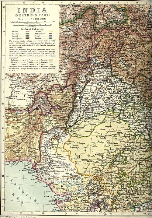
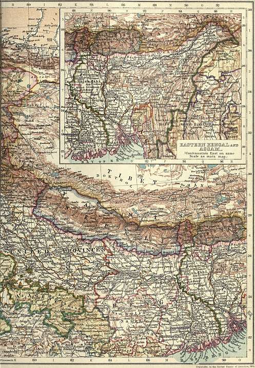
(Click to enlarge left side.)
(Click to enlarge right side.)
The deposits of the Indo-Gangetic plain are of modern date and the formation of the depression which they fill is almost certainly connected with the elevation of the Himalayas. Both movements are probably still going on. The alluvial deposits prove depression in quite recent geological times; and within the Himalayan region earthquakes are still common, whilst in Peninsular India they are rare.
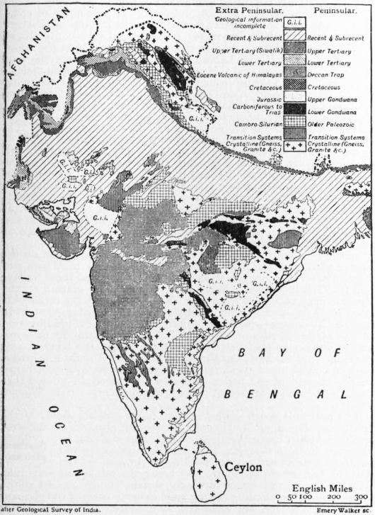
Peninsular India.—The oldest rocks of this region consist of gneiss, granite and other crystalline rocks. They cover a large area in Bengal and Madras and extend into Ceylon; and they are found also in Bundelkhand and in Gujarat. Upon them rest the unfossiliferous strata known to Indian geologists as the Transition and Vindhyan series. The Transition rocks are often violently folded and are frequently converted into schists. In the south, where they are known as the Dharwar series, they form long and narrow bands running from north-north-west to south-south-east across the ancient gneiss; and it is interesting to note that all the quartz-reefs which contain gold in paying quantities occur in the Dharwar series. The Transition rocks are of great but unknown age. The Vindhyan rocks which succeed them are also of ancient date. But long before the earliest Vindhyan rocks were laid down the Transition rocks had been altered and contorted. Occasionally the Vindhyan beds themselves are strongly folded, as in the east of the Cuddapah basin; but this was the last folding of any violence which has occurred in the Peninsula. In more recent times there have been local disturbances, and large faults have in places been formed; but the greater part of the Peninsula rocks are only slightly disturbed. The Vindhyan series is generally sharply marked off from older rocks; but in the Godavari valley there is no well-defined line between them and the Transition rocks. The Vindhyan beds are divided into two groups. The lower, with an estimated thickness of only 2000 ft., or slightly more, cover a large area—extending, with but little change of character, from the Sone valley in one direction to Cuddapah, and in a diverging line to near Bijapur—in each case a distance of over 700 m. The upper Vindhyans cover a much smaller area, but attain a thickness of about 12,000 ft. The Vindhyans are well-stratified beds of sandstone and shale, with some limestones. As yet they have yielded no trace of fossils, and their exact age is consequently unknown. They are however certainly Pre-Permian, and it is most probable that they belong to the early part of the Palaeozoic era. The total absence of fossils is a remarkable fact, and one for which it is difficult to account, as the beds are for the most part quite unaltered. Even if they are entirely of freshwater origin, we should expect that some traces of life from the waters or neighbouring land would be found.
The Gondwana series is in many respects the most interesting and important series of the Indian Peninsula. The beds are almost entirely of freshwater origin. Many subdivisions have been made, but here we need only note the main division into two great groups: Lower Gondwanas, 13,000 ft. thick; Upper Gondwanas, 11,000 ft. thick. The series is mainly confined to the area of country between the Nerbudda and the Sone on the north, and the Kistna on the south; but the western part of this region is in great part covered by newer beds. The lowest Gondwanas are very constant in character, wherever they are found; the upper members of the lower division show more variation, and this divergence of character in different districts becomes more marked in the Upper Gondwana series. Disturbances have occurred in the lower series before the formation of the upper.
The Gondwana beds contain fossils which are of very great interest. In large part these consist of plants which grew near the margins of the old rivers, and which were carried down by floods, and deposited in the alluvial plains, deltas and estuarine areas of the old Gondwana period. The plants of the Lower Gondwanas consist chiefly of acrogens (Equisetaceae and ferns) and gymnogens (cycads and conifers), the former being the more abundant. The same classes of plants occur in the Upper Gondwanas; but there the proportions are reversed, the conifers, and still more the cycads, being more numerous than the ferns, whilst the Equisetaceae are but sparingly found. But even within the limits of the Lower Gondwana series there are great diversities of vegetation, three distinct floras occurring in the three great divisions of that formation. In many respects the flora of the highest of these three divisions (the Panchet group) is more nearly related to that of the Upper Gondwanas than it is to the other Lower Gondwana floras. Although during the Gondwana period the flora of India differed greatly from that of Europe, it was strikingly similar to the contemporaneous floras of South America, South Africa and Australia. It is somewhat remarkable that this characteristically southern flora, known as the Glossopteris Flora (from the name of one of the most characteristic genera), has also been found in the north of Russia.
One of the most interesting facts in the history of the Gondwana series is the occurrence near the base (in the Talchir group) of large striated boulders in a fine mud or silt, the boulders in one place resting upon rock (of Vindhyan age) which is also striated. These beds are the result of ice-action, and it is interesting to note that a similar boulder bed is associated with the Glossopteris-bearing deposits of Australia, South Africa and probably South America.
The Damuda series, the middle division of the Lower Gondwanas, is the chief source of coal in Peninsular India, yielding more of that mineral than all other formations taken together. The Karharbari group is the only other coal-bearing formation of any value. The Damudas are 8400 ft. thick in the Raniganj coal-field, and about 10,000 ft. thick in the Satpura basin. They consist of three divisions; coal occurs in the upper and lower, ironstone (without coal) in the middle division. The Raniganj coal-field is the most important in India. It covers an area of about 500 sq. m. and is traversed by the Damuda river, along which run the road from Calcutta to Benares and the East Indian railway. From its situation and importance this coal-field is better known than any other in India. The upper or Raniganj series (stated by the Geological Survey to be 5000 ft. thick) contains eleven seams, having a total thickness of 120 ft., in the eastern district, and thirteen seams, 100 ft. thick, in the western district. The average thickness of the seams worked is from 12 to 18 ft., but occasionally a seam attains a great thickness—20 to 80 ft. The lower or Barakar series (2000 ft. thick) contains four seams, of a total thickness of 69 ft. Compared with English coals those of this coal-field are of but poor quality; they contain much ash, and are generally non-coking. The seams of the lower series are the best, and some of these at Sanktoria, near the Barakar river, are fairly good for coke and gas. The best coal in India is in the small coal-field at Karharbari. The beds there are lower in the series than those of the Raniganj field; they belong to the upper part of the Talchir group, the lowest of the Gondwana series. The coal-bearing beds cover an area of only about 11 sq. m.; there are three seams, varying from 9 to 33 ft. thick. The lowest seam is the best, and this is as good as English steam coal. This coal-field, now largely worked, is the property of the East Indian railway, which is thus supplied with fuel at a cheaper rate than any other railway in the world. Indian coal usually contains phosphoric acid, which greatly lessens its value for iron-smelting.
The Damuda series, which, as we have seen, is the chief source of coal in India, is also one of the most important sources of iron. The ore occurs in the middle division, coal in the highest and lowest. The ore is partly a clay ironstone, like that occurring in the Coal-measures of England, partly an oxide of iron or haematite, and it generally contains phosphorus. Excellent iron-ore occurs in the crystalline rocks south of the Damuda river as also in many other parts of India. Laterite (see below) is sometimes used as ore. It is very earthy and of a low percentage; but it contains only a comparatively small proportion of phosphorus.
The want of limestone for flux, within easy reach, is generally a great drawback as regards iron-smelting in India. Kankar or ghutin (concretionary carbonate of lime) is collected for this purpose from the river-beds and alluvial deposits. It sometimes contains as much as 70% of carbonate of lime; but generally the amount is much less and the fluxing value proportionally diminished. The real difficulty in India is to find the ore, the fuel, and the flux in sufficiently close proximity to yield a profit.
Contemporaneously with the formation of the upper part of the Gondwana series marine deposits of Jurassic age were laid down in Cutch. Cretaceous beds of marine origin are also found in Cutch, Kathiawar and the Nerbudda valley on the northern margin of the Peninsula, and near Pondicherry and Trichinopoly on its south-eastern margin. There is a striking difference between the Cretaceous faunas of the two areas, the fossils from the north being closely allied to those of Europe, while those of the south (Pondicherry and Trichinopoly) are very different and are much more nearly related to those from the Cretaceous of Natal. It is now very generally believed that in Jurassic and Cretaceous times a great land-mass stretched from South Africa through Madagascar to India, and that the Cretaceous deposits of Cutch, &c., were laid down upon its northern shore, and those of Pondicherry and Trichinopoly upon its southern shore. The land probably extended as far as Assam, for the Cretaceous fossils of Assam are similar to those of the south.
The enormous mass of basaltic rock known as the Deccan Trap is of great importance in the geological structure of the Indian Peninsula. It now covers about 200,000 sq. m., and formerly extended over a much wider area. Where thickest, the traps are at least 6000 ft. thick. They form some of the most striking physical features of the Peninsula, many of the most prominent hill ranges having been carved out of the basaltic flows. The great volcanic outbursts which produced this trap commenced in the Cretaceous period and lasted on into the Eocene period.
Laterite is a ferruginous and argillaceous rock, varying from 30 to 200 ft. thick, which often occurs over the trap area and also over the gneiss. As a rule it makes rather barren land; it is highly porous, and the rain rapidly sinks into it. Laterite may be roughly divided into two kinds, high-level and low-level laterites. It has usually been formed by the decomposition in situ of the rock on which it rests, but it is often broken up and re-deposited elsewhere.
Meteorology.
The great peninsula of India, with its lofty mountain ranges behind and its extensive seaboard exposed to the first violence of the winds of two oceans, forms an exceptionally valuable and interesting field for the study of meteorological phenomena.
From the gorge of the Indus to that of the Brahmaputra, a distance of 1400 m., the Himalayas form an unbroken watershed, the northern flank of which is drained by the upper valleys of these two rivers; while the Sutlej, starting from the southern Himalayas. foot of the Kailas Peak, breaks through the watershed, dividing it into two very unequal portions, that to the north-west being the smaller. The average elevation of the Himalaya crest may be taken at not less than 19,000 ft., and therefore equal to the height of the lower half of the atmosphere; and indeed few of the passes are under 16,000 or 17,000 ft. Across this mountain barrier there appears to be a constant flow of air, more active in the day-time than at night, northwards to the arid plateau of Tibet. There is no reason to believe that any transfer of air takes place across the Himalayas in a southerly direction, unless indeed in those most elevated regions of the atmosphere which lie beyond the range of observation; but a nocturnal flow of cooled air, from the southern slopes, is felt as a strong wind where the rivers debouch on the plains, more especially in the early morning hours; and this probably contributes in some degree to lower the mean temperature of that belt of the plains which fringes the mountain zone.
At the foot of the great mountain barrier, and separating it from the more ancient land which now forms the highlands of the peninsula, a broad plain, for the most part alluvial, stretches from sea to sea. On the west, in the dry region, this is occupied Indus plain. partly by the alluvial deposits of the Indus and its tributaries and the saline swamps of Cutch, partly by the rolling sands and rocky surface of the desert of Jaisalmer and Bikaner, and the more fertile tracts to the eastward watered by the Luni. Over the greater part of this region rain is of rare occurrence; and not infrequently more than a year passes without a drop falling on the parched surface. On its eastern margin, however, in the neighbourhood of the Aravalli hills, and again in the northern Punjab, rain is more frequent, occurring both in the south-west monsoon and also at the opposite season in the cold weather. As far south as Sirsa and Multan the average rainfall does not much exceed 7 in.
The alluvial plain of the Punjab passes into that of the Gangetic valley without visible interruption. Up or down this plain, at opposite seasons, sweep the monsoon winds, in a direction at right angles to that of their nominal course; and thus Gangetic plain. vapour which has been brought by winds from the Bay of Bengal is discharged as snow and rain on the peaks and hillsides of the Western Himalayas. Nearly the whole surface is under cultivation, and it ranks among the most productive as well as the most densely populated regions of the world. The rainfall diminishes from 100 in. in the south-east corner of the Gangetic delta to less than 30 in. at Agra and Delhi, and there is an average difference of from 15 to 25 in. between the northern and southern borders of the plain.
Eastward from the Bengal delta, two alluvial plains stretch up between the hills which connect the Himalayan system with that of the Burmese peninsula. The first, or the valley of Assam and the Brahmaputra, is long and narrow, bordered on Eastern Bengal. the north by the Himalayas, on the south by the lower plateau of the Garo, Khasi and Naga hills. The other, short and broad, and in great part occupied by swamps and jhils, separates the Garo, Khasi and Naga hills from those of Tippera and the Lushai country. The climate of these plains is damp and equable, and the rainfall is prolonged and generally heavy, especially on the southern slopes of the hills. A meteorological peculiarity of some interest has been noticed, more especially at the stations of Sibsagar and Silchar, viz. the great range of the diurnal variation of barometric pressure during the afternoon hours,—which is the more striking, since at Rurki, Lahore, and other stations near the foot of the Western Himalayas this range is less than in the open plains.
The highlands of the peninsula, which are cut off from the encircling ranges by the broad Indo-Gangetic plain, are divided into two unequal parts by an almost continuous chain of hills running across the country from west by south to east by Central table-land. north, just south of the Tropic of Cancer. This chain may be regarded as a single geographical feature, forming one of the principal watersheds of the peninsula, the waters to the north draining chiefly into the Nerbudda and the Ganges, those to the south into the Tapti, the Mahanadi, the Godavari and some smaller streams. In a meteorological point of view it is of considerable importance. Together with the two parallel valleys of the Nerbudda and Tapti, which drain the flanks of its western half, it gives, at opposite seasons of the year, a decided easterly and westerly direction to the winds of this part of India, and condenses a tolerably copious rainfall during the south-west monsoon.
Separated from this chain by the valley of the Nerbudda on the west, and that of the Sone on the east, the plateau of Malwa and Baghelkhand occupies the space intervening between these valleys and the Gangetic plain. On the western edge of the plateau are the Aravalli hills, which run from near Ahmedabad up to the neighbourhood of Delhi, and include one hill, Mount Abu, over 5000 ft. in height. This range exerts an important influence on the direction of the wind, and also on the rainfall. At Ajmer, an old meteorological station at the eastern foot of the range, the wind is predominantly south-west, and there and at Mount Abu the south-west monsoon rains are a regularly recurrent phenomenon,—which can hardly be said of the region of scanty and uncertain rainfall that extends from the western foot of the range and merges in the Bikaner desert.
The peninsula south of the Satpura range consists chiefly of the triangular plateau of the Deccan, terminating abruptly on the west in the Sahyadri range (Western Ghats), and shelving to the east (Eastern Ghats). This plateau is swept by the Southern plateau. south-west monsoon, but not until it has surmounted the western barrier of the Ghats; and hence the rainfall is, as a rule, light at Poona and places similarly situated under the lee of the range, and but moderate over the more easterly parts of the plateau. The rains, however, are prolonged some three or four weeks later than in tracts to the north of the Satpuras, since they are also brought by the easterly winds which blow from the Bay of Bengal in October and the early part of November, when the recurved southerly wind ceases to blow up the Gangetic valley, and sets towards the south-east coast.
At the junction of the Eastern and Western Ghats rises the bold triangular plateau of the Nilgiris, and to the south of them come the Anamalais, the Palnis, and the hills of Travancore. These ranges are separated from the Nilgiris by a broad Southern India. depression or pass known as the Palghat Gap, some 25 m. wide, the highest point of which is only 1500 ft. above the sea. This gap affords a passage to the winds which elsewhere are barred by the hills of the Ghat chain. The country to the east of the gap receives the rainfall of the south-west monsoon; and during the north-east monsoon ships passing Beypur meet with a stronger wind from the land than is felt elsewhere on the Malabar coast. In the strip of low country that fringes the peninsula below the Ghats the rainfall is heavy and the climate warm and damp, the vegetation being dense and characteristically tropical, and the steep slopes of the Ghats, where they have not been artificially cleared, thickly clothed with forest.
In Lower Burma the western face of the Arakan Yoma hills, like that of the Western Ghats in India, is exposed to the full force of the south-western monsoon, and receives a very heavy Burma. rainfall. At Sandoway this amounts to an annual mean of 212 in. It diminishes to the northwards, but even at Chittagong it is over 104 in. annually.
The country around Mandalay, as well as the hill country to the north, has suffered from severe earthquakes, one of which destroyed Ava in 1839. The general meridional direction of the ranges and valleys determines the direction of the prevailing surface winds, this being, however, subject to many local modifications. But it would appear that throughout the year there is, with but slight interruption, a steady upper current from the south-west, such as has been already noticed over the Himalayas. The rainfall in the lower part of the Irrawaddy valley, viz. the delta and the neighbouring part of the province of Pegu, is very heavy; and the climate is mild and equable at all seasons. But higher up the valley, and especially north of Pegu, the country is drier, and is characterized by a less luxuriant vegetation and a retarded and more scanty rainfall.
Within the boundaries of India almost any extreme of climate that is known to the tropics or the temperate zone can be found. It is influenced from outside by two adjoining areas. On the north, the Himalaya range and the plateau of Afghanistan Climate. shut it off from the climate of central Asia, and give it a continental climate, the characteristics of which are the prevalence of land winds, great dryness of the air, large diurnal range of temperature, and little or no precipitation. On the south the ocean gives it an oceanic climate, the chief features of which are great uniformity of temperature, small diurnal range of temperature, great dampness of the air, and more or less frequent rain. The continental type of weather prevails over almost the whole of India from December to May, and the oceanic type from June to November, thus giving rise to the two great divisions of the year, the dry season or north-east monsoon, and the rainy season or south-west monsoon. India thus becomes the type of a tropical monsoon climate. For the origin of the monsoon currents and their distribution see Monsoon.
The two monsoon periods are divided by the change of temperature, due to solar action upon the earth’s surface, into two separate seasons; and thus the Indian year may be divided into four seasons: the cold season, including the months of January and February; the hot season, comprising the months of March, April and May; the south-west monsoon period, including the months of June, July, August, September and October; and the retreating monsoon period, including the months of November and December. The temperature is nearly constant in southern India the whole year round, but in northern India, where the extremes of both heat and cold are greatest, the variation is very large.
In the cold season the mean temperature averages about 30° lower in the Punjab than in southern India. In the Punjab, the United Provinces, and northern India generally the climate resembles that of the Riviera with a brilliant cloudless The cold weather. sky and cool dry weather. This is the time for the tourist to visit India. In south India it is warmer on the west coast than on the east, and the maximum temperature is found round the headwaters of the Kistna. Calcutta, Bombay and Madras all possess the equable climate that is induced by proximity to the sea, but Calcutta enjoys a cold season which is not to be found in the other presidency towns, while the hot season is more unendurable there.
The hot season begins officially in the Punjab on the 15th of March, and from that date there is a steady rise in the temperature, induced by the fiery rays of the sun upon the baking earth, until the break of the rains in June. During this season the The hot weather. interior of the peninsula and northern India is greatly heated; and the contrast of temperature is not between northern and southern India, but between the interior of India and the coast districts and adjacent seas. The greater part of the Deccan and the Central Provinces are included within the hottest area, though in May the highest temperatures are found in Upper Sind, north-west Rajputana, and south-west Punjab. At Jacobabad the thermometer sometimes rises to 125° in the shade.
The south-west monsoon currents usually set in during the first fortnight of June on the Bombay and Bengal coasts, and give more or less general rain in every part of India during the next three months. But the distribution of the rainfall is The monsoon period. very uneven. On the face of the Western Ghats, and on the Khasi hills, overlooking the Bay of Bengal, where the mountains catch the masses of vapour as it rises off the sea, the rainfall is enormous. At Cherrapunji in the Khasi hills it averages upwards of 500 in. a year. The Bombay monsoon, after surmounting the Ghats, blows across the peninsula as a west and sometimes in places a north-west wind; but it leaves with very little rain a strip 100 to 200 m. in width in the western Deccan parallel with the Ghats, and it is this part of the Deccan, together with the Mysore table-land and the Carnatic, that is most subject to drought. Similarly the Bengal monsoon passes by the Coromandel coast and the Carnatic with an occasional shower, taking a larger volume to Masulipatam and Orissa, and abundant rain to Bengal, Assam and Cachar. The same current also supplies with rain the broad band across India, which includes the Satpura range, Chota Nagpur, the greater part of the Central Provinces and Central India, Orissa and Bengal. Rainfall rapidly diminishes to the north-west from that belt. A branch of the Bombay current blows pretty steadily through Rajputana to the Punjab, carrying some rain to the latter province. But the greater part of north-west India is served as a rule by cyclonic storms between the two currents. In September the force of the monsoon begins rapidly to decline, and after about the middle of the month it ceases to carry rain to the greater part of north-western India. In its rear springs up a gentle steady north-east wind, which gradually extends over the Bay of Bengal, and is known as the north-east monsoon. A wind similar in character, but rather more easterly in direction, simultaneously takes possession of the Arabian Sea. The months of November and December form a transition period between the monsoon and the cold season. The most unhealthy period of the year follows immediately after the rains, when malaria is prevalent, especially in northern India.
Flora.
Unlike many other large geographical areas, India is remarkable for having no distinctive botanical features peculiar to itself. It differs conspicuously in this respect from such countries as Australia or South Africa. Its vegetation is in point of fact of a composite character, and is constituted by the meeting and more or less blending of adjoining floras,—those of Persia and the south-eastern Mediterranean area to the north-west, of Siberia to the north, of China to the east, and of Malaya to the south-east. Regarded broadly, four tolerably distinct types present themselves.
1. The upper levels of the Himalayas slope northwards gradually to the Tibetan uplands, over which the Siberian temperate vegetation ranges. This is part of the great temperate flora which, with locally individualized species, but often with identical Himalayas. genera, ranges over the whole of the temperate zone of the northern hemisphere. In the western Himalayas this upland flora is marked by a strong admixture of European species, such as the columbine (Aquilegia) and hawthorn (Crataegus Oxyacantha). These disappear rapidly eastward, and are scarcely found beyond Kumaon. The base of the Himalayas is occupied by a narrow belt forming an extreme north-western extension of the Malayan type described below. Above that there is a rich temperate flora which in the eastern chain may be regarded as forming an extension of that of northern China, gradually assuming westwards more and more of a European type. Magnolia, Aucuba, Abelia and Skimmia may be mentioned as examples of Chinese genera found in the eastern Himalayas, and the tea-tree grows wild in Assam. The same coniferous trees are common to both parts of the range. Pinus longifolia extends to the Hindu-Kush; P. excelsa is found universally except in Sikkim, and has its European analogue in P. Peuce, found in the mountains of Greece. Abies smithiana extends into Afghanistan; Abies webbiana forms dense forests at altitudes of 8000 to 12,000 ft., and ranges from Bhutan to Kashmir; several junipers and the common yew (Taxus baccata) also occur. The deodar (Cedrus Deodara), which is indigenous to the mountains of Afghanistan and the north-west Himalaya, is nearly allied to the Atlantic cedar and to the cedar of Lebanon, a form of which is found in Cyprus. A notable further instance of the connexion of the western Himalayan flora with that of Europe is the holm oak (Quercus Ilex), which is characteristic of the Mediterranean region.
2. The north-western area is best marked in Sind and the Punjab, where the climate is very dry (the rainfall averaging less than 15 in.), and where the soil, though fertile, is wholly dependent on irrigation for its cultivation. The flora is a poor one in North-west. number of species, and is essentially identical with that of Persia, southern Arabia and Egypt. The low scattered jungle contains such characteristic species as Capparis aphylla, Acacia arabica (babul), Populus euphratica (the “willows” of Ps. cxxxvii. 2), Salvadora persica (erroneously identified by Royle with the mustard of Matt. xiii. 31), tamarisk, Zizyphus, Lotus, &c. The dry flora extends somewhat in a south-east direction, and then blends insensibly with that of the western peninsula; some species representing it are found in the upper Gangetic plain, and a few are widely distributed in dry parts of the country.
3. For the Malayan area, which Sir Joseph Hooker describes as Assam and Malayan peninsula. forming “the bulk of the flora of the perennially humid regions of India, as of the whole Malayan peninsula, Upper Assam valley, the Khasi mountains, the forests of the base of the Himalaya from the Brahmaputra to Nepal, of the Malabar coast, and of Ceylon,” see Assam, Ceylon and Malay Peninsula.
4. The western India type is difficult to characterize, and is in many respects intermediate between the two just preceding. It occupies a comparatively dry area, with a rainfall under 75 in. In respect to positive affinities, Sir Joseph Hooker Western India. pointed out some relations with the flora of tropical Africa as evidenced by the prevalence of such genera as Grewia and Impatiens, and the absence, common to both countries, of oaks and pines which abound in the Malayan archipelago. The annual vegetation which springs up in the rainy season includes numerous genera, such as Sida and Indigofera, which are largely represented both in Africa and Hindustan. Palms also in both countries are scanty, the most notable in southern India being the wild date (Phoenix sylvestris); Borassus and the coco-nut are cultivated. The forests, though occasionally very dense, as in the Western Ghats, are usually drier and more open than those of the Malayan type, and are often scrubby. The most important timber trees are the tún (Cedrela Toona), sál (Shorea robusta), the present area of which forms two belts separated by the Gangetic plain; satin wood (Chloroxylon Swietenia), common in the drier parts of the peninsula; sandal-wood, especially characteristic of Mysore; iron-wood (Mesua ferrea), and teak (Tectona grandis).
Fauna.
Mammals.—First among the wild animals of India must be mentioned the lion (Felis leo), which is known to have been not uncommon within historical times in Hindustan proper and the Punjab. At present the lion is confined to the Lion. Gir, or rocky hill-desert and forest of Kathiawar. A peculiar variety is there found, marked by the absence of a mane; but whether this variety deserves to be classed as a distinct species, naturalists have not yet determined. These lions at one time were almost extinct, but after being preserved since about 1890 by the Nawab of Junagarh, they have once more become comparatively plentiful. A good lion, measures from 9 to 9½ ft. in length.
The characteristic beast of prey in India is the tiger (F. tigris), which is found in every part of the country, from the slopes of the Himalayas to the Sundarbans swamps. The average length of a tiger from nose to tip of tail is 9 ft. to 10 ft. Tiger. for tigers, and 8 ft. to 9 ft. for tigresses, but a tiger of 12 ft. 4 in. has been shot. The advance of cultivation, even more than the incessant attacks of sportsmen, has gradually caused the tiger to become a rare animal in large tracts of country; but it is scarcely probable that he will ever be exterminated from India. The malarious tarái fringing the Himalayas, the uninhabitable swamps of the Gangetic delta, and the wide jungles of the central plateau are at present the chief home of the tiger. His favourite food appears to be deer, antelope and wild hog. When these abound he will disregard domestic cattle. Indeed, the natives are disposed to consider him as in some sort their protector, as he saves their crops from destruction by the wild animals on which he feeds. But when once he develops a taste for human blood, then the slaughter he works becomes truly formidable. The confirmed man-eater, which is generally an old beast, disabled from overtaking his usual prey, seems to accumulate his tale of victims in sheer cruelty rather than for food. A single tiger is known to have killed 108 people in the course of three years. Another killed an average of about 80 persons per annum. A third caused thirteen villages to be abandoned, and 250 sq. m. of land to be thrown out of cultivation. A fourth, in 1869, killed 127 people, and stopped a public road for many weeks, until the opportune arrival of an English sportsman, who at last killed him. Such cases are, of course, exceptional, and generally refer to a period long past, but they explain and justify the superstitious awe with which the tiger is regarded by the natives. The favourite mode of shooting the tiger is from the back of elephants, or from elevated platforms (macháns) of boughs in the jungle. In Central India they are shot on foot. In Assam they are sometimes speared from boats, and in the Himalayas they are said to be ensnared by bird-lime. Rewards are given by government to native shikáris for the heads of tigers, varying in time and place according to the need. In 1903 the number of persons killed by tigers in the whole of India was 866, while forty years previously 700 people were said to be killed annually in Bengal alone.
The leopard or panther (F. pardus) is far more common than the tiger in all parts of India, and at least equally destructive to life Leopard. and property. The greatest length of the leopard is about 7 ft. 6 in. A black variety, as beautiful as it is rare, is sometimes found in the extreme south of the peninsula, and also in Java.
The cheetah or hunting leopard (Cynaelurus jubatus) must be carefully distinguished from the leopard proper. This animal appears to be a native only of the Deccan, where it is trained for hunting the antelope. In some respects it approaches the dog more nearly than the cat tribe. Its limbs are long, its hair rough, and its claws blunt and only partially retractile. The speed with which it bounds upon its prey, when loosed from the cart, exceeds the swiftness of any other mammal. If it misses its first attack, it scarcely ever attempts to follow, but returns to its master. Among other species of the family Felidae found in India may be mentioned the ounce or snow leopard (F. uncia), the clouded leopard (F. nebulosa), the marbled cat (F. marmorata), the jungle cat (F. chaus), and the viverrine cat (F. viverrina).
Wolves (Canis lupus) abound throughout the open country, but are rare in the wooded districts. Their favourite prey is sheep, but they are also said to run down antelopes and hares, or rather catch them by lying in ambush. Instances of their Wolf tribe. attacking man are not uncommon, and the story of Romulus and Remus has had its counterpart in India within comparatively recent times. The Indian wolf has a dingy reddish-white fur, some of the hairs being tipped with black. By some naturalists it is regarded as a distinct species, under the name of Canis pallipes. Three distinct varieties, the white, the red and the black wolf, are found in the Tibetan Himalayas. The Indian fox (Vulpes bengalensis) is comparatively rare, but the jackal (C. aureus) abounds everywhere, making night hideous by its never-to-be-forgotten yells. The jackal, and not the fox, is usually the animal hunted by the packs of hounds occasionally kept by Europeans.
The wild dog, or dhole (Cyon), is found in all the wilder jungles of India, including Assam and Lower Burma. Its characteristic is that it hunts in packs, sometimes containing thirty dogs, and does not give tongue. When once a pack of wild dogs Dog. has put up any animal, that animal’s doom is sealed. They do not leave it for days, and finally bring it to bay, or run it down exhausted. A peculiar variety of wild dog exists in the Karen hills of Burma, thus described from a specimen in confinement. It was black and white, as hairy as a skye-terrier, and as large as a medium-sized spaniel. It had an invariable habit of digging a hole in the ground, into which it crawled backwards, remaining there all day with only its nose and ferrety eyes visible. Among other dogs of India are the pariah, which is merely a mongrel, run wild and half starved; the poligar dog, an immense creature peculiar to the south; the greyhound, used for coursing; and the mastiff of Tibet and Bhutan. The striped hyaena (Hyaena striata) is common, being found wherever the wolf is absent. Like the wolf, it is very destructive both to the flocks and to children.
Of bears, the common black or sloth bear (Melursus ursinus) is common throughout India wherever rocky hills and forests occur. It is distinguished by a white horse-shoe mark on its breast. Its food consists of ants, honey and fruit. When Bear. disturbed it will attack man, and it is a dangerous antagonist, for it always strikes at the face. The Himalayan or Tibetan sun bear (Ursus torquatus) is found along the north, from the Punjab to Assam. During the summer it remains high up in the mountains, near the limit of snow, but in the winter it descends to 5000 ft. and even lower. Its congener, the Malayan sun bear (U. malayanus), is found in Lower Burma.
The elephant (Elephas indicus) is found in many parts of India, though not in the north-west. Contrary to what might be anticipated from its size and from the habits of its African cousin, the Indian elephant is now, at any rate, an inhabitant, Elephant. not of the plains, but of the hills; and even on the hills it is usually found among the higher ridges and plateaus, and not in the valleys. From the peninsula of India the elephant has been gradually exterminated, being only found now in the primeval forests of Coorg, Mysore and Travancore, and in the tributary state of Orissa. It still exists in places along the tarái or submontane fringe of the Himalayas. The main source of supply at the present time is the confused mass of hills which forms the north-east boundary of British India, from Assam to Burma. Two varieties are there distinguished, the gunda or tusker, and the makna or hine, which has no tusks. The reports of the height of the elephant, like those of its intelligence, seem to be exaggerated. The maximum is probably 12 ft. If hunted, the elephant must be attacked on foot, and the sport is therefore dangerous, especially as the animal has but few parts vulnerable to a bullet. The regular mode of catching elephants is by means of a keddah, or gigantic stockade, into which a wild herd is driven, then starved into submission, and tamed by animals already domesticated. The practice of capturing them in pitfalls is discouraged as cruel and wasteful. Elephants now form a government monopoly everywhere in India. The shooting of them is prohibited, except when they become dangerous to man or destructive to the crops; and the right of capturing them is only leased out upon conditions. A special law, under the title of “The Elephants Preservation Act” (No. VI. of 1879), regulates this licensing system. Whoever kills, captures or injures an elephant, or attempts to do so, without a licence, is punishable by a fine of 500 rupees for the first offence; and a similar fine, together with six months’ imprisonment, for a second offence. Though the supply is decreasing, elephants continue to be in great demand. Their chief use is in the timber trade and for government transport. They are also bought up by native chiefs at high prices for purposes of ostentation.
Of the rhinoceros, three distinct varieties are enumerated, two with a single and one with a double horn. The most familiar is the Rhinoceros unicornis, commonly found in the Brahmaputra valley. It has but one horn, and is covered with massive Rhinoceros. folds of naked skin. It sometimes attains a height of 6 ft.; its horn, which is much prized by the natives for medicinal purposes, seldom exceeds 14 in. in length. It frequents swampy, shady spots, and wallows in mud like a pig. The traditional antipathy of the rhinoceros to the elephant seems to be mythical. The Javan rhinoceros (R. sondaicus) is found in the Sundarbans and also in Burma. It also has but one horn, and mainly differs from the foregoing in being smaller, and having less prominent “shields.” The Sumatran rhinoceros (R. sumatrensis) is found from Chittagong southwards through Burma. It has two horns and a bristly coat.
The wild hog (Sus cristatus) is well known as affording the most Wild hog. exciting sport in the world—“pig-sticking.” It frequents cultivated situations, and is the most mischievous enemy of the villager. A rare animal, called the pigmy hog (S. salvanius), exists in the tarái of Nepal and Sikkim, and has been shot in Assam. Its height is only 10 in., and its weight does not exceed 12 ℔.
The Wild ass.wild ass (Equus hemionus) is confined to the sandy deserts of Sind and Cutch, where, from its speed and timidity, it is almost unapproachable.
Many wild species of the sheep and goat tribe are to be found in the Himalayan ranges. The Ovis ammon and O. poli are Tibetan rather than Indian species. The urial and the shapu are kindred species of wild sheep (Ovis vignei), found respectively in Ladakh and the Suleiman range. The former Sheep and goats. comes down to 2000 ft. above the sea, the latter is never seen at altitudes lower than 12,000 ft. The barhal, or blue wild sheep (O. nahura), and the markhor and tahr (both wild goats), also inhabit the Himalayas. A variety of the ibex is also found there, as well as in the highest ranges of southern India. The sarau (Nemorhaedus bubalinus), allied to the chamois, has a wide range in the mountains of the north, from the Himalayas to Assam and Burma.
The antelope tribe is represented by comparatively few species, as compared with the great number peculiar to Africa. The antelope proper (Antilope), the “black buck” of sportsmen, is very generally distributed. Its special habitat is salt plains, Antelopes. as on the coast-line of Gujarat and Orissa, where herds of fifty does may be seen, accompanied by a single buck. The doe is of a light fawn colour and has no horns. The colour of the buck is a deep brown-black above, sharply marked off from the white of the belly. His spiral horns, twisted for three or four turns like a corkscrew, often reach the length of 30 in. The flesh is dry and unsavoury, but is permitted meat for Hindus, even of the Brahman caste. The nílgai, or blue cow (Boselaephus tragocamelus) is also widely distributed, but specially abounds in Hindustan Proper and Gujarat. As with the antelope, the male alone has the dark-blue colour. The nílgai is held peculiarly sacred by Hindus, from its fancied kinship to the cow, and on this account its destructive inroads upon the crops are tolerated. The four-horned antelope (Tetracerus quadricornis) and the gazelle (Gazella bennetti), the chinkara or “ravine deer” of sportsmen, are also found in India.
The king of the deer tribe is the sámbhar or jarau (Cervus unicolor), erroneously called “elk” by sportsmen. It is found on the forest-clad hills in all parts of the country. It is of a deep-brown Deer. colour, with hair on its neck almost like a mane; and it stands nearly 5 ft. high, with spreading antlers nearly 3 ft. in length. Next in size is the swamp deer or bara-singha, signifying “twelve points” (C. duvauceli), which is common in Lower Bengal and Assam. The chitál or spotted deer (C. axis) is generally admitted to be the most beautiful inhabitant of the Indian jungles. Other species include the hog deer (C. porcinus), the barking deer or muntjac (Cervulus muntjac), and the chevrotain or mouse deer (Tragulus meminna). The musk deer (Moschus moschiferus) is confined to Tibet.
The ox tribe is represented in India by some of its noblest species. The gaur (Bos gaurus), the “bison” of sportsmen, is found in all Bison. the hill jungles of the country, in the Western Ghats, in Central India, in Assam, and in Burma. This animal sometimes attains the height of 20 hands (close on 7 ft.), measuring from the hump above the shoulder. Its short curved horns and skull are enormously massive. Its colour is dark chestnut, or coffee-brown. From the difficult nature of its habitat, and from the ferocity with which it charges an enemy, the pursuit of the bison is no less dangerous and no less exciting than that of the tiger or the elephant. Akin to the gaur, though not identical, are the gayál or mithun (B. frontalis), confined to the hills of the north-east frontier, where it is domesticated for sacrificial purposes by the aboriginal tribes, and the tsine or banting (B. sondaicus), found in Burma. The wild buffalo (Bos bubalus) differs from the tame buffalo only in being larger Buffalo. and more fierce. The finest specimens come from Assam and Burma. The horns of the bull are thicker than those of the cow, but the horns of the cow are larger. A head has been known to measure 13 ft. 6 in. in circumference, and 6 ft. 6 in. between the tips. The greatest height is 6 ft. The colour is a slaty black; the hide is immensely thick, with scanty hairs. Alone perhaps of all wild animals in India, the buffalo will charge unprovoked. Even tame buffaloes seem to have an inveterate dislike to Europeans.
The rat and mouse family is only too numerous. Conspicuous in it is the loathsome bandicoot (Nesocia bandicota), which sometimes Rat tribe. measures 2 ft. in length, including its tail, and weighs 3 ℔. It burrows under houses, and is very destructive to plants, fruit and even poultry. More interesting is the tree mouse (Vandeleusia), about 7 in. long, which makes its nest in palms and bamboos. The field rats (Mus mettada) occasionally multiply so exceedingly as to diminish the out-turn of the local harvest, and to require special measures for their destruction.
Birds.—The ornithology of India, though it is not considered so rich in specimens of gorgeous and variegated plumage as that of other tropical regions, contains many splendid and curious varieties. Some are clothed in nature’s gay attire, Birds. others distinguished by strength, size and fierceness. The parrot tribe is the most remarkable for beauty. Among birds of prey, four vultures are found, including the common scavengers (Gyps indicus and G. bengalensis). The eagles comprise many species, but none to surpass the golden eagle of Europe. Of falcons, there are the peregrine (F. peregrinus), the shain (F. peregrinator), and the lagar (F. jugger), which are all trained by the natives for hawking; of hawks, the shikara (Astur badius), the goshawk (A. palumbarius), and the sparrow-hawk (Accipiter nisus). Kingfishers of various kinds and herons are sought for their plumage. No bird is more popular with natives than the maina (Acridotheres tristis), a member of the starling family, which lives contentedly in a cage, and can be taught to pronounce words, especially the name of the god Rama. Water-fowl are especially numerous. Of game-birds, the floriken (Sypheotis aurita) is valued as much for its rarity as for the delicacy of its flesh. Snipe (Gallinago coelestis) abound at certain seasons, in such numbers that one gun has been known to make a bag of one hundred brace in a day. Pigeons, partridges, quail, plover, duck, teal, sheldrake, widgeon—all of many varieties—complete the list of small game. The red jungle fowl (Gallus ferrugineus), supposed to be the ancestor of our own poultry, is not good eating; and the same may be said of the peacock (Pavo cristatus), except when young. The pheasant does not occur in India Proper, though a white variety is found in Burma.