VOLUME IX SLICE VII Equation to Ethics (continued 4)
Reading edition
See Sveriges Historia, vol. iii. (Stockholm, 1880); Robert Nisbet Bain, Scandinavia, cap. 4-6 (Cambridge, 1905); Eric Tegel, Konung Eriks den XIV. historia (Stockholm, 1751).
(R. N. B.)
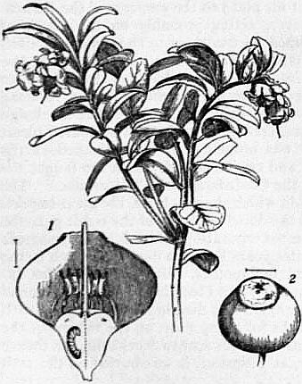
Fig. 1.—Vaccinium vitis-idaea, with leaf and flower, nat. size. 1, Flower of V. myrtillus, cut lengthwise. 2, Fruit of same.
ERICACEAE, in botany, a natural order of plants belonging to the higher or gamopetalous division of Dicotyledons. They are woody plants, sometimes with a slender creeping stem as in bilberry, Vaccinium (fig. 1), or Andromeda (fig. 2), or forming low bushes as in the heaths, or larger, sometimes becoming tree-like, as in species of Rhododendron. The leaves are alternate, opposite or whorled in arrangement, and in their form and structure show well-marked adaptation for life in dry or exposed situations. Thus in the true heaths they are needle-like, with the margins often rolled back to form a groove or an almost closed chamber on the under side. In others such as Rhododendron or Arbutus they are often leathery and evergreen, the strongly cuticularized upper surface protecting a water-storing tissue situated above the green layers of the leaf. The flowers are sometimes solitary and axillary or terminal as in Andromeda, but are generally arranged in racemose inflorescences at the end of the branches as in Arbutus and Rhododendron, or on small lateral shoots as in Erica. They are hermaphrodite and generally regular with parts in 4 or 5, thus: sepals 4 or 5, petals 4 or 5, stamens 8 or 10 in two series, the outer of which is opposite the petals, and carpels 4 or 5. The corolla is usually more or less bell-shaped, and in the heaths persists in a dry state in the fruit. The petals with the stamens are situated on the outer edge of a honey-secreting disk. The anthers show a very great variety in shape, the halves are often more or less free and often appendaged; they open to allow the escape of the pollen by a terminal pore or slit. The carpels are united to form a 4- to 5-chambered ovary, which bears a simple elongated style ending in a capitate stigma; each ovary-chamber contains one to many ovules attached to a central placenta. The brightly coloured corolla, the presence of nectar and the scent render the flowers attractive to insects, and the projection of the stigma beyond the anthers favours crossing. The fruit is generally a capsule containing many seeds, as in Erica (fig. 3) or Rhododendron; sometimes a berry as in Arbutus.
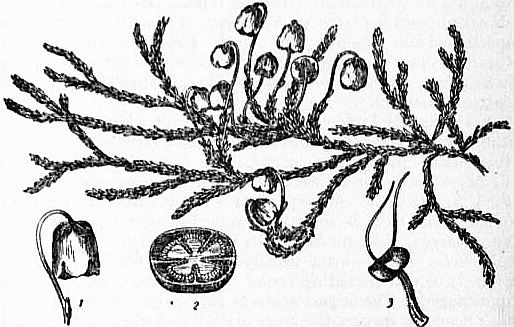
Fig. 2.—Andromeda Hypnoides, nat. size. 1, Flower; 2, Unripe fruit cut across; 3, Stamen—all enlarged.
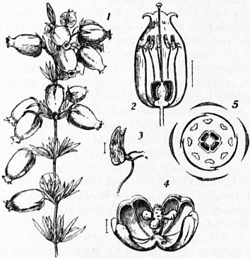
Fig. 3.
1, Flowering shoot of Erica cinerea, about 1½ nat. size. 2, Flower cut lengthwise. 3, Stamen showing appendages and porous dehiscence of anther. 4, Capsule showing the loculicidal dehiscence; a few seeds remain attached to the central axis. 5, Diagram of the flower having four sepals, four divisions of the corolla, eight stamens in two rows, and four divisions of the pistil.
The order falls into four distinct tribes, which are characterized by the relative position of the ovary and by the fruit and seed. They are as follows:—
1. Rhododendron tribe, characterized by capsular fruit, seed with a loose coat, deciduous petals and anthers without appendages. It consists mainly of the great genus Rhododendron (in which Azalea is included by recent botanists), which is chiefly developed in the mountains of eastern Asia, many species occurring on the Himalayas. Dabeocia, St Dabeoc’s heath, occurs in Ireland.
2. Arbutus Tribe.—Fruit a berry or capsule, petals deciduous and anthers with bristle-like appendages, chiefly north temperate to arctic in distribution. Arbutus Unedo, the strawberry-tree, so called from its large scarlet berry, is a southern European species which extends into south Ireland. Arctostaphylos (bearberry) and Andromeda are arctic and alpine genera occurring in Britain. Epigaea repens is the trailing arbutus or mayflower of Atlantic America.
3. Vaccinium Tribe.—Ovary inferior, fruit a berry. Extends from the north temperate zone to the mountains of the tropics. Vaccinium, the largest genus, has four British species: V. Myrtillus is the bilberry(q.v.), blaeberry or whortleberry, V. Vitis-Idaea the cowberry, and V. Oxycoccos the cranberry (q.v.). This tribe is sometimes regarded as a separate order Vacciniaceae, distinguished by its inferior ovary.
4. Erica Tribe.—Fruit usually a capsule, seeds round, not winged; corolla persisting round the ripe fruit; anthers often appendaged. The largest genus is Erica, the true heath (q.v.), with over 400 species, the great majority of which are confined to the Cape; others occur on the mountains of tropical Africa and in Europe and North Africa, especially the Mediterranean region. E. cinerea (purple heather) and E. Tetralix (cross-leaved heath) are common British heaths. Calluna is the ling or Scotch heather.
ERICHSEN, SIR JOHN ERIC, Bart. (1818-1896), British surgeon, born on the 19th of July 1818 at Copenhagen, was the son of Eric Erichsen, a member of a well-known Danish family. He studied medicine at University College, London, and at Paris, devoting himself in the early years of his career to physiology, and lecturing on general anatomy and physiology at University College hospital. In 1844 he was secretary to the physiological section of the British Association, and in 1845 he was awarded the Fothergillian gold medal of the Royal Humane Society for his essay on asphyxia. In 1848 he was appointed assistant surgeon at University College hospital, and in 1850 became full surgeon and professor of surgery, his lectures and clinical teaching being much admired; and in 1875 he joined the consulting staff. His Science and Art of Surgery (1853) went through many editions. He rose to be president of the College of Surgeons in 1880. From 1879 to 1881 he was president of the Royal Medical and Chirurgical Society. He was created a baronet in 1895, having been for some years surgeon-extraordinary to Queen Victoria. As a surgeon his reputation was world-wide, and he counts (says Sir W. MacCormac in his volume on the Centenary of the Royal College of Surgeons) “among the makers of modern surgery.” He was a recognized authority on concussion of the spine, and was often called to give evidence in court on obscure cases caused by railway accidents, &c. He died at Folkestone on the 23rd of September 1896.
ERICHT, LOCH, a lake partly in Inverness-shire and partly in Perthshire, Scotland, lying between the districts of Badenoch on the N. and Rannoch on the S. The boundary line is drawn from a point opposite to the mouth of the Alder, and follows the centre of the longitudinal axis north-eastwards to 56° 50′ N., where it strikes eastwards to the shore. All of the lake to the S. and E. of this line belongs to Perthshire, the rest, forming the major portion, to Inverness-shire. It is a lonely lake, situated in extremely wild surroundings at a height of 1153 ft. above the sea, being thus the loftiest lake of large size in the United Kingdom. It is over 14½ m. long, with a mean breadth of half a mile and over 1 m. at its maximum. Its area amounts to some 7¼ sq. m., and it receives the drainage of an area of nearly 50½ sq. m. The mean depth is 189 ft., and the maximum 512 ft. It has a general trend from N.E. to S.W., the head lying 1 m. from Dalwhinnie station on the Highland railway. It receives many streams, and discharges at the south-western extremity by the Ericht. Salmon and trout afford good fishing. The surrounding mountains are lofty and rugged. Ben Alder (3757 ft.) on the west shore is the chief feature of the great Corrour deer forest. The only point of interest on the banks is the cavern, near the mouth of the Alder, in which Prince Charles Edward concealed himself for a time after the battle of Culloden.
ERICSSON, JOHN (1803-1889), Swedish-American naval engineer, was born at Langbanshyttan, Wermland, Sweden, on the 31st of July 1803. He was the second son of Olaf Ericsson, an inspector of mines, who died in 1818. Showing from his earliest years a strong mechanical bent, young Ericsson, at the age of twelve, was employed as a draughtsman by the Swedish Canal Company. From 1820 to 1827 he served in the army, where his drawing and military maps attracted the attention of the king, and he soon attained the rank of captain. In 1826 he went to London, at first on leave of absence from his regiment, and in partnership with John Braithwaite constructed the “Novelty,” a locomotive engine for the Liverpool & Manchester railway competition at Rainhill in 1829, when the prize, however, was won by Stephenson’s “Rocket.” The number of Ericsson’s inventions at this period was very great. Among other things he worked out a plan for marine engines placed entirely below the water-line. Such engines were made for the “Victory,” for Captain (afterwards Sir) John Ross’s voyage to the Arctic regions in 1829, but they did not prove satisfactory. In 1833 his caloric engine was made public. In 1836 he took out a patent for a screw-propeller, and though the priority of his invention could not be maintained, he was afterwards awarded a one-fifth share of the £20,000 given by the Admiralty for it. At this time Captain Stockton, of the United States navy, gave an order for a small iron vessel to be built by Laird of Birkenhead, and to be fitted by Ericsson with engines and screw. This vessel reached New York in May 1839. A few months later Ericsson followed his steamer to New York, and there he resided for the rest of his life, establishing himself as an engineer and a builder of iron ships. In 1848 he was naturalized as a citizen of the United States. He had many difficulties to contend with, and it was only by slow degrees that he established his fame and won his way to competence. At his death he seems to have been worth about £50,000. The provision of defensive armour for ships of war had long occupied his attention, and he had constructed plans and a model of a vessel lying low in the water, carrying one heavy gun in a circular turret mounted on a turntable. In 1854 he sent his plans to the emperor of the French. Louis Napoleon, however, acting probably on the advice of Dupuy de Lôme, declined to use them. The American Civil War, and the report that the Confederates were converting the “Merrimac” into an ironclad, caused the navy department to invite proposals for the construction of armoured ships. Among others, Ericsson replied, and as it was thought that his design might be serviceable in inland waters, the first armoured turret ship, the “Monitor,” was ordered; she was launched on the 30th of January 1862, and on the 9th of March she fought the celebrated action with the Confederate ram “Merrimac.” The peculiar circumstances in which she was built, the great importance of the battle, and the decisive nature of the result gave the “Monitor” an exaggerated reputation, which further experience did not confirm. In later years Ericsson devoted himself to the study of torpedoes and sun motors. He published Solar Investigations (New York, 1875) and Contributions to the Centennial Exhibition (New York, 1877). He died in New York on the 8th of March 1889, and in the following year, on the request of the Swedish government, his body was sent to Stockholm and thence into Wermland, where, at Filipstad, it was buried on the 15th of September.
A Life of Ericsson by William Conant Church was published in New York in 1890 and in London in 1893.
ERIDANUS, or Fluvius (“the river”), in astronomy, a constellation of the southern hemisphere, mentioned by Eudoxus (4th century B.C.) and Aratus (3rd century B.C.); Ptolemy catalogued 34 stars in it. θ Eridani, a fine double star of magnitudes 3.5 and 5.5, is now of the third magnitude. It is supposed to be identical with the Achernar of Al-Sufi, who described it as of the first magnitude; this star has therefore decreased in brilliancy in historic times. The star ο2 Eridani (numbered 40 by Flamsteed) was discovered to be a ternary star group by Herschel in 1783; it consists of a close pair, of magnitudes 9.2 and 10.9, revolving in a period of 180 years, associated with a star of magnitude 4.5, which is distant from the pair by 82″; these stars have an exceptionally swift proper motion, about 4″ per annum. Eridanus was the ancient name of the river Po.
ERIDU, one of the oldest religious centres of the Sumerians, described in the ancient Babylonian records as the “city of the deep.” The special god of this city was Ea (q.v.), god of the sea and of wisdom, and the prominence given to this god in the incantation literature of Babylonia and Assyria suggests not only that many of our magical texts are to be traced ultimately to the temple of Ea at Eridu, but that this side of the Babylonian religion had its origin in that place. Certain of the most ancient Babylonian myths, especially that of Adapa, may also be traced back to the shrine of Ea at Eridu. But while of the first importance in matters of religion, there is no evidence in Babylonian literature of any special political importance attaching to Eridu, and certainly at no time within our knowledge did it exercise hegemony in Babylonia. The site of Eridu was discovered by J.E. Taylor in 1854, in a ruin then called by the natives Abu-Shahrein, a few miles south-south-west of Moghair, ancient Ur, nearly in the centre of the dry bed of an inland sea, a deep valley, 15 m. at its broadest, covered for the most part with a nitrous incrustation, separated from the alluvial plain about Moghair by a low, pebbly, sandstone range, called the Hazem, but open toward the north to the Euphrates and stretching southward to the Khanega wadi below Suk-esh-Sheiukh. In the rainy season this valley becomes a sea, flooded by the discharge of the Khanega; in summer the Arabs dig holes here which supply them with brackish water. The ruins, in which Taylor conducted brief excavations, consist of a platform of fine sand enclosed by a sandstone wall, 20 ft. high, the corners toward the cardinal points, on the N.W. part of which was a pyramidal tower of two stages, constructed of sun-dried brick, cased with a wall of kiln-burned brick, the whole still standing to a height of about 70 ft. above the platform. The summit of the first stage was reached by a staircase on the S.E. side, 15 ft. wide and 70 ft. long, constructed of polished marble slabs, fastened with copper bolts, flanked at the foot by two curious columns. An inclined road led up to the second stage on the N.W. side. Pieces of polished alabaster and marble, with small pieces of pure gold and gold-headed copper nails, found on and about the top of the second stage, indicated that a small but richly adorned sacred chamber, apparently plated within or without in gold, formerly crowned the top of this structure. Around the whole tower was a pavement of inscribed baked bricks, resting on a layer of clay 2 ft. thick. On the S.E. part of the terrace were the remains of several edifices, containing suites of rooms. Inscriptions on the bricks identified the site as that of Eridu. Since Taylor’s time the place has not been visited by any explorer, owing to the unsafe condition of the neighbourhood; but T.K. Loftus (1854) and J.P. Peters (1890) both report having seen it from the summit of Moghair. The latter states that the Arabs at that time called the ruin Nowawis, and apparently no longer knew the name Abu-Shahrein. Through an error, in many recent maps and Assyriological publications Eridu is described as located in the alluvial plain, between the Tigris and the Euphrates. It was, in fact, an island city in an estuary of the Persian Gulf, stretching up into the Arabian plateau. Originally “on the shore of the sea,” as the old records aver, it is now about 120 m. from the head of the Persian Gulf. Calculating from the present rate of deposit of alluvium at the head of that gulf, Eridu should have been founded as early as the seventh millennium B.C. It is mentioned in historical inscriptions from the earliest times onward, as late as the 6th century B.C. From the evidence of Taylor’s excavations, it would seem that the site was abandoned about the close of the Babylonian period.
See J.E. Taylor, Journal of the Royal Asiatic Society, vol. xv. (1855); F. Delitzsch, Wo lag das Paradies? (1881); J.P. Peters, Nippur (1897); M. Jastrow, The Religion of Babylonia and Assyria (1898); H.V. Hilprecht, Excavations in Assyria and Babylonia (1904); L.W. King, A History of Sumer and Akkad (1910).
(J. P. Pe.)
ERIE, the most southerly of the Great Lakes of North America, between 41° 23′ and 42° 53′ N., and 78° 51′ and 83° 28′ W., bounded W. by the state of Michigan, S. and S.E. by Ohio, Pennsylvania and New York, and N. by the province of Ontario. It is nearly elliptical, the major axis, 250 m. long, lying east and west; its greatest breadth is 60 m.; its area about 10,000 sq. m.; and the total area of its basin 34,412 sq. m. Its elevation above mean sea-level is 573 ft.; and its surface is nearly 9 ft. below that of Lake Huron, which discharges into it through St Clair river, Lake St Clair and Detroit river, and is 327 ft. above that of Lake Ontario, this great difference being absorbed by the rapids and falls in the Niagara river, which joins the two lakes. Lake Erie is very shallow, and may be divided into three basins, the western extending to Point Pelee and including all the islands, containing about 1200 sq. m., with a comparatively flat bottom at 5 to 6 fathoms; the main basin, between Point Pelee and the narrows at Long Point, containing about 6700 sq. m., and having a marked shelving bottom deepening gradually to 14 fathoms; and the portion east of the narrows, containing about 2100 sq. m., having a depression 30 fathoms deep just east from Long Point, with an extensive flat of 11 fathoms depth between it and the main basin. The Canadian shore is low and flat throughout, the United States shore is low but bordered by an elevated plateau through which the rivers have cut deep channels. The lake basin is relatively so small that the rivers are without importance; Grand river, on the north shore, is the largest tributary. The flat alluvial soil bordering on the lake is very fertile, and the climate is well adapted for fruit cultivation. Large quantities of peaches, grapes and small fruits are grown; the islands in the west end have a climate much warmer and more equable than the adjoining mainland, and are practically covered with vineyards. The low clayey or sandy shores are subject to erosion by waves. In severe storms the water near shore is filled with sand, which is deposited where the currents are checked around the ends of jetties in such a way as to form bars out into the lake across improved channels. This shoaling has rendered continuous dredging necessary at every harbour on the lake west of Erie, Pa. In consequence of the shallowness of the lake its waters are easily disturbed, making navigation very rough and dangerous, and causing large fluctuations of surface. Strong winds are frequent, as nearly every cyclonic depression traversing North America, either from the westward or the Gulf of Mexico, passes near enough to Lake Erie to be felt. Westerly gales are more frequent, and have more effect on the water surface than easterly ones, lowering the water as much as 7 to 8 ft. at the west end and raising it 5 to 8 ft. at the east end. The worst storms occur in autumn, when the immense quantity of shipping on the lake makes them specially destructive. There are no tides, and usually only a slight current towards the outlet, though powerful currents are temporarily produced by the rapid return of waters after a storm, and during the height of a westerly gale there is invariably a reflex current into the west end of the lake. There is an annual fluctuation in the level of the lake, varying from a minimum of 9 in. to a maximum of 2 ft., the normal low level occurring in February and the high level in midsummer. Standard high water (of 1838) is 575.11 ft. above mean sea-level, and the lowest record was 570.8 in November 1895. The harbours and exits of the lake freeze over, but the body of the lake never freezes completely.
Ice-breaking car ferries run across the lake all winter. General navigation opens as a rule in the middle of April and closes in the middle of December. The volume of traffic is immense, because practically all freight from the more westerly lakes finds terminal harbours in Lake Erie. Official statistics of commerce passing through the Detroit river into the lake during the season of 1906 show that 35,128 vessels, having a net register of 50,673,897 tons, carried 63,805,571 (short) tons of freight, valued at $662,971,053. The 1175 vessels engaged in this business were valued at $106,223,000. Over 90% of the whole traffic is in United States ships to United States ports. Fine passenger steamers run nightly between Buffalo and Cleveland and Detroit, and there are many shorter passenger routes.
The large traffic on Lake Erie has brought into existence a number of important harbours on the south shore, nearly all artificially made and deepened, with entrances between two breakwaters running into the lake at right angles to the coast line. The principal of these are Toledo, Sandusky, Huron, Vermilion, Lorain, Cleveland, Fairport, Ashtabula, Conneaut, Erie (a natural harbour), Dunkirk and Buffalo, Rondeau, Port Stanley, Port Burwell, Port Dover, Port Maitland and Port Colborne. The Miami and Erie canal, leading from Maumee river to Cincinnati, 244½ m., with a branch to Port Jefferson, 14 m., with locks 90 by 15 by 4 ft., connects with Lake Erie through Toledo. The Erie canal leading from Buffalo to the Hudson river at Troy, and connecting with Lake Ontario at Oswego, had a capacity for boats 98 ft. long, 17 ft. 10 in. beam, with 6 ft. draught, until in 1907 the State of New York undertook its deepening to accommodate boats of 1000 tons capacity. Buffalo from its position at the eastern limit of deep draught lake navigation is a city of first rate commercial importance. Its harbour is formed by an artificial breakwater, built parallel with the shore about half a mile distant from it. It receives practically all the Lake Erie grain shipments besides large quantities of iron ore, lumber and copper, and is a large shipping port for coal, principally anthracite. It has over 600 m. of railway tracks to accommodate lake freights. The Welland canal, 26¾ m. long, connecting Lake Ontario and Lake Erie, with locks 270 by 45 by 14 ft., leaves Lake Erie at Port Colborne, where the Canadian government have constructed an artificial harbour and elevators for transhipment of grain from upper lake freighters to lighters of canal capacity.
Fishing operations are carried on extensively in Lake Erie, the fish being taken with gill nets, seines and pound nets. Each state touching the lake has its own fishery regulations, which differ amongst themselves as well as from those of the Dominion. Both nations maintain a Fishery Protection Service, and the fisheries are replenished from artificial hatcheries. The most numerous and valuable fish are the lesser white fish (Coregonus artedi, Le Sueur), pickerel (Stizostedion vitreum, Walb.), pike (Lucius lucius, L.), and white fish (Coregonus clupeiformis, Mitchill), in the order named. The fish caught are estimated to be worth annually $1,000,000. They are collected in fishing tugs and distributed by rail throughout the United States and Canada.
Bibliography.—Bulletin No. 17, Survey of Northern and North-western Lakes, U.S. Lake Survey Office, War Dept. (Detroit, 1907); U.S. Hydrographic Office, Publication No. 108D, Sailing Directions for Lake Erie, &c. (Washington, 1902); Sailing Directions for the Canadian Shore of Lake Erie, Department of Marine and Fisheries (Ottawa, 1897); J.O. Curwood, The Great Lakes (New York, 1909); E. Channing and M.F. Lansing, The Great Lakes (New York, 1909).
(W. P. A.)
ERIE, a city, a port of entry, and the county-seat of Erie county, Pennsylvania, U.S.A., on Lake Erie, 148 m. by rail N. of Pittsburg and near the N.W. corner of the state. Pop. (1890) 40,634; (1900) 52,733, of whom 11,957 were foreign-born, including 5226 from Germany and 1468 from Ireland, and 26,797 were of foreign parentage (both parents foreign-born), including 13,316 of German parentage and 4203 of Irish parentage; (1910 census) 66,525. Erie is served by the New York, Chicago & St Louis, the Lake Shore & Michigan Southern, the Erie & Pittsburg (Pennsylvania Company), the Philadelphia & Erie (Pennsylvania railway), and the Bessemer & Lake Erie railways, and by steamboat lines to many important lake ports. The city extends over an area of about 7 sq. m., which for the most part is quite level and is from 50 to 175 ft. above the lake. Erie has a fine harbour about 4 m. in length, more than 1 m. in width, and with an average depth of about 20 ft.; it is nearly enclosed by Presque Isle, a long narrow strip of land of about 3000 acres from 300 ft. to 1 m. in width, and the national government has protected its entrance and deepened its channel by constructing two long breakwaters. Most of the streets of the city are 60 ft. wide—a few are 100 ft.—and nearly all intersect at right angles; they are paved with brick and asphalt, and many in the residential quarters are shaded with fine elms and maples. The city has four parks, in one of which is a soldiers’ and sailors’ monument of granite and bronze, and not far away, along the shore of lake and bay, are several attractive summer resorts. Among Erie’s more prominent buildings are the United States government building, the city hall, the public library, and the county court house. The city’s charitable institutions consist of two general hospitals, each of which has a training school for nurses; a municipal hospital, an orphan asylum, a home for the friendless, two old folks’ homes, and a bureau of charities; here, also, on a bluff, within a large enclosure and overlooking both lake and city, is the state soldiers’ and sailors’ home, and near by is a monument erected to the memory of General Anthony Wayne, who died here on the 15th of December 1796.
Erie is the commercial centre of a large and rich grape-growing and agricultural district, has an extensive trade with the lake ports and by rail (chiefly in coal, iron ore, lumber and grain), and is an important manufacturing centre, among its products being iron, engines, boilers, brass castings, stoves, car heaters, flour, malt liquors, lumber, planing mill products, cooperage products, paper and wood pulp, cigars and other tobacco goods, gas meters, rubber goods, pipe organs, pianos and chemicals. In 1905 the city’s factory products were valued at $19,911,567, the value of foundry and machine-shop products being $6,723,819, of flour and grist-mill products $1,444,450, and of malt liquors $882,493. The municipality owns and operates its water-works.
On the site of Erie the French erected Fort Presque Isle in 1753, and about it founded a village of a few hundred inhabitants. George Washington, on behalf of the governor of Virginia, came in the same year to Fort Le Bœuf (on the site of the present Waterford), 20 m. distant, to protest against the French fortifying this section of country. The protest, however, was unheeded. The village was abandoned in or before 1758, owing probably to an epidemic of smallpox, and the fort was abandoned in 1759. It was occupied by the British in 1760, but on the 22nd of June 1763 this was one of the several forts captured by the Indians during the Conspiracy of Pontiac. In 1764 the British regained nominal control and retained it until 1785, when it passed into the possession of the United States. The place was laid out as a town in 1795; in 1800 it became the county-seat of the newly-erected county of Erie; it was incorporated as a borough in 1805, the charter of that year being revised in 1833; and in 1851 it was incorporated as a city. At Erie were built within less than six months most of the vessels with which Commodore Oliver H. Perry won his naval victory over the British off Put-in-Bay on the 10th of September 1813.
ERIGENA, JOHANNES SCOTUS (c. 800-c. 877), medieval philosopher and theologian. His real name was Johannes Scotus (Scottus) or John the Scot. The combination Johannes Scotus Erigena has not been traced earlier than Ussher and Gale; even Gale uses it only in the heading of the version of St Maximus. The date of Erigena’s birth is very uncertain, and there is no evidence to show definitely where he was born. The name Scotus, which has often been taken to imply Scottish origin, really favours the theory that he was an Irishman according to the then usage of Scotus or Scotigena. Prudentius, bishop of Troyes, definitely states that he was of Irish extraction. The pseudonym commonly read Erigena, used by himself in the titles of his versions of Dionysius the Areopagite, is Ierugena (in later MSS. Erugena and Eriugena), formed apparently on the analogy of Graiugena (“Greek-born”), which he applies to St Maximus. There seems no reason to doubt that Eriugena is connected with Erin, the name for Ireland, and Ierugena suggests the Greek ἱερός, ἱερὸς, νῆσος being a common name for Ireland. On the other hand, William of Malmesbury prefers to read Heruligena, which would make Scotus a Pannonian, while Bale says he was born at St David’s, Dempster connects him with Ayr, and Gale with Eriuven in Hereford. Some early writers thought there were two persons, John Scotus and John Erigena.
Of Erigena’s early life nothing is known. Bale quotes the story that he travelled in Greece, Italy and Gaul, and studied not only Greek, but also Arabic and Chaldaean. Since, however, Bale describes him as “ex patricio genitore natus,” it is a reasonable inference (so R.L. Poole) that Bale confused him with one John, the son of Patricius, a Spaniard, who tells much the same story of his own travels. The knowledge of Greek displayed in Erigena’s works is not such as to compel us to conclude that he had actually visited Greece. That he had a competent acquaintance with Greek is manifest from his translations of Dionysius the Areopagite and of Maximus, from the manner in which he refers to Aristotle, and from his evident familiarity with Neoplatonist writers and the fathers of the early church. Roger Bacon, in his severe criticism on the ignorance of Greek displayed by the most eminent scholastic writers, expressly exempts Erigena, and ascribes to him a knowledge of Aristotle in the original.
Among other legends which have at various times been attached to Erigena are that he was invited to France by Charlemagne, and that he was one of the founders of the university of Paris. The only portion of Erigena’s life as to which we possess accurate information was that spent at the court of Charles the Bald. Charles invited him to France soon after his accession to the throne, probably in the year 843, and placed him at the head of the court school (schola palatina). The reputation of this school seems to have increased greatly under Erigena’s leadership, and the philosopher himself was treated with indulgence by the king. William of Malmesbury’s amusing story illustrates both the character of Scotus and the position he occupied at the French court. The king having asked, “Quid distat inter sottum et Scottum?” Erigena replied, “Mensa tantum.”
The first of the works known to have been written by Erigena during this period was a treatise on the eucharist, which has not come down to us (by some it has been identified with a treatise by Ratramnus, De corpore et sanguine Domini). In it he seems to have advanced the doctrine that the eucharist was merely symbolical or commemorative, an opinion for which Berengarius was at a later date censured and condemned. As a part of his penance Berengarius is said to have been compelled to burn publicly Erigena’s treatise. So far as we can learn, however, Erigena’s orthodoxy was not at the time suspected, and a few years later he was selected by Hincmar, archbishop of Reims, to defend the doctrine of liberty of will against the extreme predestinarianism of the monk Gottschalk (Gotteschalchus). The treatise De divina praedestinatione, composed on this occasion, has been preserved, and from its general tenor one cannot be surprised that the author’s orthodoxy was at once and vehemently suspected. Erigena argues the question entirely on speculative grounds, and starts with the bold affirmation that philosophy and religion are fundamentally one and the same—“Conficitur inde veram esse philosophiam veram religionem, conversimque veram religionem esse veram philosophiam.” Even more significant is his handling of authority and reason, to which we shall presently refer. The work was warmly assailed by Drepanius Florus, canon of Lyons, and Prudentius, and was condemned by two councils—that of Valence in 855, and that of Langres in 859. By the former council his arguments were described as Pultes Scotorum (“Scots porridge”) and commentum diaboli (“an invention of the devil”).
Erigena’s next work was a Latin translation of Dionysius the Areopagite (see Dionysius Areopagiticus) undertaken at the request of Charles the Bald. This also has been preserved, and fragments of a commentary by Erigena on Dionysius have been discovered in MS. A translation of the Areopagite’s pantheistical writings was not likely to alter the opinion already formed as to Erigena’s orthodoxy. Pope Nicholas I. was offended that the work had not been submitted for approval before being given to the world, and ordered Charles to send Erigena to Rome, or at least to dismiss him from his court. There is no evidence, however, that this order was attended to.
The latter part of his life is involved in total obscurity. The story that in 882 he was invited to Oxford by Alfred the Great, that he laboured there for many years, became abbot at Malmesbury, and was stabbed to death by his pupils with their “styles,” is apparently without any satisfactory foundation, and doubtless refers to some other Johannes. Erigena in all probability never left France, and Hauréau has advanced some reasons for fixing the date of his death about 877.
Erigena is the most interesting figure among the middle-age writers. The freedom of his speculation, and the boldness with which he works out his logical or dialectical system of the universe, altogether prevent us from classing him along with the scholastics properly so called. He marks, indeed, a stage of transition from the older Platonizing philosophy to the later and more rigid scholasticism. In no sense whatever can it be affirmed that with Erigena philosophy is in the service of theology. The above-quoted assertion as to the substantial identity between philosophy and religion is indeed repeated almost totidem verbis by many of the later scholastic writers, but its significance altogether depends upon the selection of one or other term of the identity as fundamental or primary. Now there is no possibility of mistaking Erigena’s position: to him philosophy or reason is first, is primitive; authority or religion is secondary, derived. “Auctoritas siquidem ex vera ratione processit, ratio vero nequaquam ex auctoritate. Omnis enim auctoritas, quae vera ratione non approbatur, infirma videtur esse. Vera autem ratio, quum virtutibus suis rata atque immutabilis munitur, nullius auctoritatis adstipulatione roborari indiget” (De divisione naturae, i. 71). F.D. Maurice, the only historian of note who declines to ascribe a rationalizing tendency to Erigena, obscures the question by the manner in which he states it. He asks his readers, after weighing the evidence advanced, to determine “whether he (Erigena) used his philosophy to explain away his theology, or to bring out what he conceived to be the fullest meaning of it.” These alternatives seem to be wrongly put. “Explaining away theology” is something wholly foreign to the philosophy of that age; and even if we accept the alternative that Erigena endeavours speculatively to bring out the full meaning of theology, we are by no means driven to the conclusion that he was primarily or principally a theologian. He does not start with the datum of theology as the completed body of truth, requiring only elucidation and interpretation; his fundamental thought is that of the universe, nature, τὸ πᾶν, or God, as the ultimate unity which works itself out into the rational system of the world. Man and all that concerns man are but parts of this system, and are to be explained by reference to it; for explanation or understanding of a thing is determination of its place in the universal or all. Religion or revelation is one element or factor in the divine process, a stage or phase of the ultimate rational life. The highest faculty of man, reason, intellectus, intellectualis visio, is that which is not content with the individual or partial, but grasps the whole and thereby comprehends the parts. In this highest effort of reason, which is indeed God thinking in man, thought and being are at one, the opposition of being and thought is overcome. When Erigena starts with such propositions, it is clearly impossible to understand his position and work if we insist on regarding him as a scholastic, accepting the dogmas of the church as ultimate data, and endeavouring only to present them in due order and defend them by argument.
Erigena’s great work, De divisione naturae, which was condemned by a council at Sens, by Honorius III. (1225), who described it as “swarming with worms of heretical perversity,” and by Gregory XIII. in 1585, is arranged in five books. The form of exposition is that of dialogue; the method of reasoning is the syllogistic. The leading thoughts are the following. Natura is the name for the universal, the totality of all things, containing in itself being and non-being. It is the unity of which all special phenomena are manifestations. But of this nature there are four distinct classes:—(1) that which creates and is not created; (2) that which is created and creates; (3) that which is created and does not create; (4) that which neither is created nor creates. The first is God as the ground or origin of all things, the last is God as the final end or goal of all things, that into which the world of created things ultimately returns. The second and third together compose the created universe, which is the manifestation of God, God in processu, Theophania. Thus we distinguish in the divine system beginning, middle and end; but these three are in essence one—the difference is only the consequence of our finite comprehension. We are compelled to envisage this eternal process under the form of time, to apply temporal distinctions to that which is extra- or supra-temporal. The universe of created things, as we have seen, is twofold:—first, that which is created and creates—the primordial ideas, archetypes, immutable relations, divine acts of will, according to which individual things are formed; second, that which is created and does not create, the world of individuals, the effects of the primordial causes, without which the causes have no true being. Created things have no individual or self-independent existence; they are only in God; and each thing is a manifestation of the divine, theophania, divina apparitio.
God alone, the uncreated creator of all, has true being. He is the true universal, all-containing and incomprehensible. The lower cannot comprehend the higher, and therefore we must say that the existence of God is above being, above essence; God is above goodness, above wisdom, above truth. No finite predicates can be applied to him; his mode of being cannot be determined by any category. True theology is negative. Nevertheless the world, as the theophania, the revelation of God, enables us so far to understand the divine essence. We recognize his being in the being of all things, his wisdom in their orderly arrangement, his life in their constant motion. Thus God is for us a Trinity—the Father as substance or being (οὐσία), the Son as wisdom (δύναμις), the Spirit as life (ἐνέργια). These three are realized in the universe—the Father as the system of things, the Son as the word, i.e. the realm of ideas, the Spirit as the life or moving force which introduces individuality and which ultimately draws back all things into the divine unity. In man, as the noblest of created things, the Trinity is seen most perfectly reflected; intellectus (νοῦς), ratio (λογος) and sensus (διάνοια) make up the threefold thread of his being. Not in man alone, however, but in all things, God is to be regarded as realizing himself, as becoming incarnate.
The infinite essence of God, which may indeed be described as nihilum (nothing) is that from which all is created, from which all proceeds or emanates. The first procession or emanation, as above indicated, is the realm of ideas in the Platonic sense, the word or wisdom of God. These ideas compose a whole or inseparable unity, but we are able in a dim way to think of them as a system logically arranged. Thus the highest idea is that of goodness; things are, only if they are good; being without well-being is naught. Essence participates in goodness—that which is good has being, and is therefore to be regarded as a species of good. Life, again, is a species of essence, wisdom a species of life, and so on, always descending from genus to species in a rigorous logical fashion.
The ideas are the eternal causes, which, under the moving influence of the spirit, manifest themselves in their effects, the individual created things. Manifestation, however, is part of the being or essence of the causes, that is to say, if we interpret the expression, God of necessity manifests himself in the world and is not without the world. Further, as the causes are eternal, timeless, so creation is eternal, timeless. The Mosaic account, then, is to be looked upon merely as a mode in which is faintly shadowed forth what is above finite comprehension. It is altogether allegorical, and requires to be interpreted. Paradise and the Fall have no local or temporal being. Man was originally sinless and without distinction of sex. Only after the introduction of sin did man lose his spiritual body, and acquire the animal nature with its distinction of sex. Woman is the impersonation of man’s sensuous and fallen nature; on the final return to the divine unity, distinction of sex will vanish, and the spiritual body will be regained.
The most remarkable and at the same time the most obscure portion of the work is that in which the final return to God is handled. Naturally sin is a necessary preliminary to this redemption, and Erigena has the greatest difficulty in accounting for the fact of sin. If God is true being, then sin can have no substantive existence; it cannot be said that God knows of sin, for to God knowing and being are one. In the universe of things, as a universe, there can be no sin; there must be perfect harmony. Sin, in fact, results from the will of the individual who falsely represents something as good which is not so. This misdirected will is punished by finding that the objects after which it thirsts are in truth vanity and emptiness. Hell is not to be regarded as having local existence; it is the inner state of the sinful will. As the object of punishment is not the will or the individual himself, but the misdirection of the will, so the result of punishment is the final purification and redemption of all. Even the devils shall be saved. All, however, are not saved at once; the stages of the return to the final unity, corresponding to the stages in the creative process, are numerous, and are passed through slowly. The ultimate goal is deificatio, theosis or resumption into the divine being, when the individual soul is raised to a full knowledge of God, and where knowing and being are one. After all have been restored to the divine unity, there is no further creation. The ultimate unity is that which neither is created nor creates.
Editions.—There is a complete edition of Erigena’s works in J.P. Migne’s Patrologiae cursus completus (vol. cxxii.), edited by H.J. Floss (Paris, 1853). The De divina praedestinatione was published in Gilbert Mauguin’s Veterum auctorum qui nono saeculo de praedestinatione et gratia scripserunt opera et fragmenta (Paris, 1650). The commentary (“Expositiones”) on Dionysius’ Hierarchiae caelestes appeared in the Appendix ad opera edita ab A. Maio (ed. J. Cozza, Rome, 1871). Of the De divisione naturae, editions have been published by Thomas Gale (Oxford, 1681); C.B. Schlüter (Münster, 1838); and in Floss’s Opera omnia; there is a German translation by Ludwig Noack, Johannes Scotus Erigena über die Eintheilung der Natur (3 vols., 1874-1876). Erigena was also the author of some poems edited by L. Traube in Monumenta Germaniae historica. Poëtae Latini aevi Carolini, iii. (1896). A commentary on the Opuscula sacra of Boëtius is attributed to him and edited by E.K. Rand (1906). Monographs on Erigena’s life and works are numerous; see St René Taillandier, Scot Érigène et la philosophie scholastique (1843); T. Christlieb, Leben u. Lehre des Johannes Scotus Erigena (Gotha, 1860); J.N. Huber, Johannes Scotus Erigena (Munich, 1861); W. Kaulich, Das speculative System des Johannes Scotus Erigena (Prague, 1860); A. Stöckl, De Joh. Scoto Erigena (1867); L. Noack, Über Leben und Schriften des Joh. Scotus Erigena: die Wissenschaft und Bildung seiner Zeit (Leipzig, 1876); R.L. Poole, Medieval Thought (1884), and article in Dictionary of National Biography; T. Wotschke, Fichte und Erigena (Halle, 1896); M. Baumgartner in Wetzer and Welte’s Kirchenlexikon, x. (1897); Alice Gardner’s Studies in John the Scot (1900); J. Dräseke, Joh. Scotus Erigena und seine Gewährsmänner (Leipzig, 1902); S.M. Deutsch in Herzog-Hauck’s Realencyklopädie für protestantische Theologie, xviii. (1906); J.E. Sandys, Hist. of Classical Scholarship (1906), pp. 491-495. See also the general works on scholastic philosophy, especially Hauréau, Stöckl and Kaulich. An admirable résumé is given by F.D. Maurice, Medieval Phil. pp. 45-79.
(R. Ad.; J. M. M.)
ERIGONE, in Greek mythology, daughter of Icarius, the hero of the Attic deme Icaria. Her father, who had been taught by Dionysus to make wine, gave some to some shepherds, who became intoxicated. Their companions, thinking they had been poisoned, killed Icarius and buried him under a tree on Mount Hymettus (or threw his body into a well). Erigone, guided by her faithful dog Maera, found his grave, and hanged herself on the tree. Dionysus sent a plague on the land, and all the maidens of Athens, in a fit of madness, hanged themselves like Erigone. Icarius, Erigone and Maera were set among the stars as Boötes (or Arcturus), Virgo and Procyon. The festival called Aeora (the “swing”) was subsequently instituted to propitiate Icarius and Erigone. Various small images (in Lat. oscilla) were suspended on trees and swung backwards and forwards, and offerings of fruit were made (Hyginus, Fab. 130, Poët. astron. ii. 4; Apollodorus iii. 14). The story was probably intended to explain the origin of these oscilla, by which Dionysus, as god of trees (Dendrites), was propitiated, and the baneful influence of the dog-star averted (see also Oscilla).
ERIN, an ancient name for Ireland. The oldest form of the word is Ériu, of which Érinn is the dative case. Ériu was itself almost certainly a contraction from a still more primitive form Iberiu or Iveriu; for when the name of the island was written in ancient Greek it appeared as Ἰουερνιά (Ivernia), and in Latin as Iberio, Hiberio or Hibernia, the first syllable of the word Ériu being thus represented in the classical languages by two distinct vowel sounds separated by b or v. Of the Latin variants, Iberio is the form found in the most ancient Irish MSS., such as the Confession of St Patrick, and the same saint’s Epistle to Coroticus. Further evidence to the same effect is found in the fact that the ancient Breton and Welsh names for Ireland were Ywerddon or Iverdon. In later Gaelic literature the primitive form Ériu became the dissyllable Éire; hence the Norsemen called the island the land of Éire, i.e. Ireland, the latter word being originally pronounced in three syllables. (See Ireland: Notices of Ireland in Greek and Roman writers.) Nothing is known as to the meaning of the word in any of its forms, and Whitley Stokes’s suggestion that it may have been connected with the Sanskrit avara, meaning “western,” is admittedly no more than conjecture. There was, indeed, a native Irish legend, worthless from the standpoint of etymology, to account for the origin of the name. According to this myth there were three kings of the Dedannans reigning in Ireland at the coming of the Milesians, named MacColl, MacKecht and MacGrena. The wife of the first was Eire, and from her the name of the country was derived. Curiously, Ireland in ancient Erse poetry was often called “Fodla” or “Bauba,” and these were the wives of the other two kings in the legend.
ERINNA, Greek poet, contemporary and friend of Sappho, a native of Rhodes or the adjacent island of Telos, flourished about 600 (according to Eusebius, 350 B.C.). Although she died at the early age of nineteen, her poems were among the most famous of her time and considered to rank with those of Homer. Of her best-known poem, Ἠλακάτη (the Distaff), written in a mixture of Aeolic and Doric, which contained 300 hexameter lines, only 4 lines are now extant. Three epigrams in the Palatine anthology, also ascribed to her, probably belong to a later date.
The fragments have been edited (with those of Alcaeus) by J. Pellegrino (1894).
ERINYES (Lat. Furiae), in Greek mythology, the avenging deities, properly the angry goddesses or goddesses of the curse pronounced upon evil-doers. According to Hesiod (Theog. 185) they were the daughters of Earth, and sprang from the blood of the mutilated Uranus; in Aeschylus (Eum. 321) they are the daughters of Night, in Sophocles (O.C. 40) of Darkness and Earth. Sometimes one Erinys is mentioned, sometimes several; Euripides first spoke of them as three in number, to whom later Alexandrian writers gave the names Alecto (unceasing in anger), Tisiphone (avenger of murder), Megaera (jealous). Their home is the world below, whence they ascend to earth to pursue the wicked. They punish all offences against the laws of human society, such as perjury, violation of the rites of hospitality, and, above all, the murder of relations. But they are not without benevolent and beneficent attributes. When the sinner has expiated his crime they are ready to forgive. Thus, their persecution of Orestes ceases after his acquittal by the Areopagus. It is said that on this occasion they were first called Eumenides (“the kindly”), a euphemistic variant of their real name. At Athens, however, where they had a sanctuary at the foot of the Areopagus hill and a sacred grove at Colonus, their regular name was Semnae (venerable). Black sheep were sacrificed to them during the night by the light of torches. A festival was held in their honour every year, superintended by a special priesthood, at which the offerings consisted of milk and honey mixed with water, but no wine. In Aeschylus, the Erinyes are represented as awful, Gorgon-like women, wearing long black robes, with snaky locks, bloodshot eyes and claw-like nails. Later, they are winged maidens of serious aspect, in the garb of huntresses, with snakes or torches in their hair, carrying scourges, torches or sickles. The identification of Erinyes with Sanskrit Saranyu, the swift-speeding storm cloud, is rejected by modern etymologists; according to M. Bréal, the Erinyes are the personification of the formula of imprecation (ἀρά), while E. Rohde sees in them the spirits of the dead, the angry souls of murdered men.
See C.O. Müller, Dissertations on the Eumenides of Aeschylus, (Eng. tr., 1835); A. Rosenberg, Die Erinyen (1874); J.E. Harrison, Prolegomena to the Study of Greek Religion (1903); and Journal of Hellenic Studies, xix. p. 205, according to whom the Erinyes were primarily local ancestral ghosts, potent for good or evil after death, earth genii, originally conceived as embodied in the form of snakes, whose primitive haunt and sanctuary was the omphalos at Delphi; E. Rohde, Psyche (1903); A. Rapp in Roscher’s Lexikon der Mythologie, and J.A. Hild in Daremberg and Saglio’s Dictionnaire des antiquités, s.v. Furiae.
ERIPHYLE, in Greek mythology, sister of Adrastus and wife of Amphiaraus. Having been bribed by Polyneices with the necklace of Harmonia, she persuaded her husband to take part in the expedition of the Seven against Thebes, although he knew it would prove fatal to him. Before setting out, the seer charged his sons to slay their mother as soon as they heard of his death. The attack on Thebes was repulsed, and during the flight the earth opened and swallowed up Amphiaraus together with his chariot. His son Alcmaeon, as he had been bidden, slew his mother, and was driven from place to place by the Erinyes, seeking purification and a new home (Apollodorus iii. 6. 7).
ERIS, in Greek mythology, a sister of the war-god Ares (Homer, Iliad, iv. 440), and in the Hesiodic theogony (225) a daughter of Night. In the later legends of the Trojan War, Eris, not having been invited to the marriage festival of Peleus and Thetis, flings a golden apple (the “apple of discord”) among the guests, to be given to the most beautiful. The claims of the three deities Hera, Aphrodite and Athena are decided by Paris in favour of Aphrodite, who as a reward assists him to gain possession of Helen (Hyginus, Fab. 92; Lucian, Charidemus, 17). Hesiod also mentions (W. and D. 24) a beneficent Eris, the personification of honourable rivalry. In Virgil (Aeneid, viii. 702) and other Roman poets Eris is represented by Discordia.
ERITH, an urban district in the north-western parliamentary division of Kent, England, 14 m. E. by S. of London, on the South Eastern & Chatham railway. Pop. (1891) 13,414; (1901) 25,296. It lies on the south bank of the Thames and extends up the hills above the shore, many villas having been erected on the higher ground. The park of a former seat, Belvedere, was thus built over (c. 1860), and the mansion became a home for disabled seamen. The church of St John the Baptist, though largely altered by modern restoration, retains Early English to Perpendicular portions, and some early monuments and brasses. Erith has large engineering and gun factories, and in the neighbourhood are gunpowder, oil, glue and manure works. The southern outfall works of the London main drainage system are at Crossness in the neighbouring lowland called Plumstead Marshes. Erith is the headquarters of several yacht clubs. Erith, the name of which is commonly derived from A.S. Ærra-hythe (old haven), was anciently a borough, and was granted a market and fairs in 1313. Down to the close of the 17th century it was of some importance as a naval station.
ERITREA, an Italian colony on the African coast of the Red Sea. It extends from Ras Kasar, a cape 110 m. S. of Suakin, in 18° 2′ N., as far as Ras Dumeira (12° 42′ N.), in the Strait of Bab-el-Mandeb, a coast-line of about 650 m. The colony is bounded inland by the Anglo-Egyptian Sudan, Abyssinia and French Somaliland. It consists of the coast lands lying between the capes named and of part of the northern portion of the Abyssinian plateau. The total area is about 60,000 sq. m. The population is approximately 450,000, of which, exclusive of soldiers, not more than 3000 are whites.
The land frontier starting from Ras Kasar runs in a south-westerly direction until in about 14° 15′ N., 36° 35′ E. it reaches the river Setit, some distance above the junction of that stream with the Atbara. This, the farthest point inland, is 198 m. S.W. of Massawa. The frontier now turns east, following for a short distance the course of the river Setit; thence it strikes north-easterly to the Mareb, and from 38° E. follows that river and its tributaries the Belesa and Muna, until within 42 m. of the sea directly south of Annesley Bay. At this point the frontier turns south and east, crossing the Afar or Danakil country at a distance of 60 kilometres (37.28 m.) from the coast-line. About 12° 20′ N. the French possessions in Somaliland are reached. Here the frontier turns N.E. and so continues until the coast of the Red Sea is again reached at a point south of the town of Raheita. In the southern part of the colony are small sultanates, such as those of Aussa and Raheita, which are under Italian protection. The Dahlak archipelago and other groups of islands along the coast belong to Eritrea.
Physical Features.—The coast-line is of coral formation and is, in the neighbourhood of Massawa, thickly studded with small islands. The chief indentations are Annesley Bay, immediately south of Massawa, and Assab Bay in the south. The colony consists of two widely differing regions. The northern division is part of the Abyssinian highlands. The southern division, part of the Afar or Danakil country, includes all the territory of the colony south of Annesley Bay. These two regions are connected by a narrow strip of land behind Annesley Bay, where the Abyssinian hills approach close to the sea. From this bay the coast-line trends S.E. so that at Tajura Bay the distance between the Abyssinian hills and the sea is over 200 m. The Afar country is part of the East African rift-valley, and in the southern parts of the valley its surface is diversified by ranges of hills, frequently volcanic, and by lakes. The plains, however, extend over large areas, they are generally arid and are often covered with mimosa trees which form a kind of jungle called by the natives khala. The torrents which descend from the Abyssinian plateau usually fail to reach the sea. They are mostly bordered by dense vegetation; in the dry season water is found in pools in the river beds or can be obtained by digging. The principal rivers enter and are lost in one or other of two salt plains or basins, that of Asali in the north and that of Aussa in the south. The Hawash flows through the Aussa country in a N.E. direction, but is lost in lakes Abbebad and Aussa (see Abyssinia). The Raguali and other rivers drain into the Asali basin. This basin, like that of Aussa, is in places 200 ft. below sea-level. On the west the Asali basin reaches to the Abyssinian foot-hills; in its southern part is the small lake Alelbad. The eastern edge of the basin is formed by a ridge of gypsum and on its margin grow palms. In parts the salt lies thick on the plain, which then has the appearance of a lake frozen over. South of Lake Alelbad is a volcano called Artali or Erta-alé (“the smoky”), and farther to the S.E., in about 13° 15′ N., is the peak of Afdera, which was in eruption in June 1907. The hills, 1000 to 4000 ft. in height, which run more or less parallel to and a few miles from the coast, include the volcano of Dubbi (reported active in 1861), some 30 m. S. of the port of Edd (Eddi). In 14° 52′ N., 39° 53′ E. and near the northern end of the zone of depression the volcano of Alid (2985 ft.) rises from the trough. Its chief crest forms an elongated ring and encloses a crater over half a mile in diameter and with walls 350 ft. high. North and south of Alid extends a vast lava field. Dubbi and Alid are in Italian territory; the greater part of Afar belongs to Abyssinia.
At Annesley Bay the narrow coast plain is succeeded by foothills separated by small valleys through which flow innumerable streams. From these hills the ascent to the plateau which constitutes northern Eritrea is very steep. This tableland, which has a general elevation of about 6500 ft., is fairly fertile despite a desert region—Sheb—to the S.E. of Keren. It is characterized by rich, well-watered valleys, verdant plains and flat-topped hills with steep sides, running in ranges or isolated. The highest hills in Eritrean territory rise to about 10,000 ft. The plateau is known by various names, the region directly west of Massawa being called Hamasen. To the west and north the plateau sinks in terraces to the plains of the Sudan, and eastward falls more abruptly to the Red Sea, the coast plain, known as the Samhar, consisting of sandy country covered with mimosa and, along the khors, with a somewhat richer vegetation.
The colony contains no navigable streams. For a short distance the Setit (known in its upper course as the Takazze), a tributary of the Atbara, forms the frontier, as does also in its upper course the Gash or Mareb (see Abyssinia). The Mareb, often dry in summer, in the floods is a large and impassable river. Both the Setit and Mareb have a general westerly course across the Abyssinian plateau. The Baraka (otherwise Barka) and Anseba rise in the Hamasen plateau near Asmara within a short distance of each other. The Baraka flows west and then north; the Anseba, which has a more easterly course, also flows northward and joins the Baraka a little N. of 17° N. A few miles below the confluence the Baraka leaves Italian territory. It is (as is the Anseba) an intermittent stream. After heavy rain it discharges some of its water into the Red Sea north of Tokar. The whole of the hill country north of Asmara belongs to the drainage area of the Baraka or Anseba. Of the numerous streams which, north of the Danakil country, run direct from the hills to the Red Sea, the Hadas may be mentioned, as along the valley of that stream is one of the most frequented routes to the tableland. The Hadas, in time of flood, reaches the ocean near Adulis in Annesley Bay.
Climate.—The climate in different parts of the colony varies greatly. Three distinct climatic zones are found:—(1) that of the coastlands, including altitudes up to 1650 ft., (2) that of the escarpments and valleys, and (3) that of the high plateau and alpine summits. In the coast zone the heat and humidity are excessive during most of the year, June, September and October being the hottest months. Rains occur between November and April, during which time the temperature is lower. In this zone malarial fevers prevail in winter. The heat is greatest at Massawa, where the mean temperature averages 88° F., but where, in summer, the thermometer often rises to 120° F. in the shade. In the second zone the climate is more temperate and there is considerable variation in temperature owing to nocturnal radiation. This zone falls within the régime of the summer monsoon rains, while those districts adjoining the coast zone enjoy also winter rains. August is the most rainy and May the hottest month. On the high plateau, i.e. the third zone, the climate is generally moderately cool. Slight rain falls in the spring and abundant monsoon rains from June to September. The heat is greatest in the dry season, November to April. Above 8500 ft. the climate becomes sub-alpine in character.
Flora and Fauna.—In the low country the flora differs little from that of tropical Africa generally, whilst on the plateau the vegetation is characteristic of the temperate zone. The olive tree grows on the high plateau and covers the flanks of the hills to within 3000 ft. of sea-level. The sycamore-fig tree grows to enormous proportions in parts of the plateau. Lower down durra, maize and bultuc grow in profusion. In the northern part of the colony, especially along the Khor Baraka, the dom palm flourishes. The fauna includes, in the low country, the lion, panther, elephant, camel, and antelope of numerous species. On the plateau the fauna is that of Abyssinia (q.v.).
Inhabitants.—The inhabitants of the plains and foothills are for the most part semi-nomad shepherds, living on durra and milk. In the north these people are largely of Arab or Hamitic stock, such as the Beni-Amer, but include various negro tribes. Afar and Somali form the population of the southern regions. The inhabitants of the plateau are Abyssinians. The nomads are Mussulmans and are, as a rule, docile and pacific, though the Danakils are given to occasional raiding. The Abyssinians are more warlike, but they have settled down under Italian rule. Among the native industries are mat-weaving, cotton-weaving, silver-working and rudimentary iron and leather working. (See Afars; Somaliland and Abyssinia.)
Towns.—The principal places on the coast are Massawa (q.v.), pop. about 10,000, the chief seaport of the colony, Assab, chief town of the Danakil region, to which converges the trade from Abyssinia across the Aussa country, and Zula (q.v.), identified with the ancient Adulis. The chief town in the interior is Asmara (q.v.), the capital of the colony and under the Abyssinians capital of the province of Hamasen, and favourite headquarters of Ras Alula (see below and also Abyssinia). It is situated 7800 ft. above the sea, and has something of the aspect of a European town. Keren, 50 m. N.W. of Asmara, is the centre for a district (Bogos) fertilized by the upper course of the Anseba; Agordat, on the river Baraka, on the road from Keren to Kassala, is the centre of the Beni-Amer, Algheden and Sabderat tribes; Mogolo, on the lower Mareb, is the rendezvous of the Baria and Baza tribes. Towards Abyssinia the chief towns are Saganeiti (capital of the Okulé-Kusai province), Godofelassi and Adi-Ugri, the two latter situated in the fertile plain of the Seraé; Adiquala, on the edge of the Mareb gorge; and Arrasa, the centre of the districts constituting the province of Deki-Tesfa.
Agriculture and Trade.—The nomads of the plains possess large herds of cattle and camels. The low country is almost entirely pastoral and unsuited for the cultivation of crops. On the other hand almost all European cereals flourish in the intermediate zone and on the high plateau, and the Abyssinian is a good agriculturist and understands irrigation. Numbers of emigrants from Italy possess farms on the plateau. Experiments in the cultivation of coffee, tobacco and cotton have given good results in the intermediate zone. Besides camels and oxen, sheep and goats are numerous, and meat, hides and butter are articles of local trade. Hides are the principal export (about £50,000 a year). Wax, gum, coffee and ivory are also exported. Pearl fishing is carried on at Massawa and the Dahlak islands. The annual value of the fisheries is about £40,000 (pearls £10,000, mother of pearl £30,000). Gold mines are worked near Asmara. Salt, obtained from the salt lakes in the Aussa and Danakil countries, is a valuable article of commerce. Cotton goods are the chief imports. There is a little trade with northern Abyssinia, but it is undeveloped. For the five years 1901-1905 the average value of the external trade was £456,000 per annum. The imports more than doubled the exports.
Communications.—A railway, 65 m. long, connects Massawa with Asmara. An extension of the line is planned from Asmara to Sabderat and Kassala. The whole territory is crossed by camel and mule paths between the sea and the high plateau, and between the various centres of population. Every valley that brings water to the Red Sea has a route leading to the high plateau. The great arteries, however, number three, which, starting from Massawa by way of Asmara, run, two to Abyssinia, and one to Kassala and Khartum. They are all more or less practicable for carts, and are flanked by a good telegraph line as long as they lie in Italian territory. There are also two caravan routes from Assab Bay, across the Danakil country to southern Abyssinia. The northern leads by a comparatively easy ascent to Yejju, the more southern follows the valley of the Hawash. A telegraph line 500 m. long connects Massawa with Adis Ababa via Asmara. Massawa is also telegraphically connected with the outside world by a cable to Perim via Assab. There is regular steamship communication with Italy.
Administration.—Eritrea is administered by a civil governor responsible to the ministry of foreign affairs at Rome. It is divided into six provinces, each governed by a regional commissioner. Some tracts of frontier territory are detached from the various regions and entrusted to political residents, as, for instance, on the Sudan frontier and also on the Abyssinian boundary, where strict surveillance is necessary to repress raiding incursions from Tigré, and where the chief intelligence department is established. The six regions or principal provinces are:—Asmara, which includes Hamasen and other small districts; Keren, which comprises the high territories to the north of Asmara, i.e. the Bogos country; Massawa, extending over all the tribes between the high plateau and the sea from the Hababs to the Danakil; Assab, which extends from Edd to Raheita; Okulé-Kusai, the plateau country S.E. of Asmara; Seraé, including Deki-Tesfa, the country S.W. of Asmara. The regional commissioners and the political residents act either by means of the village headmen (Shum or Chicca), by the chiefs of districts in the few localities where villages are still organized in districts, or by the headmen of tribes, and by the councils of the elders wherever these remain.
Revenue is derived from customs duties, direct taxation and tribute paid by the nomad tribes. The local revenue, which for the period 1897-1907 was about £100,000 a year, is supplemented by grants from Italy, the total cost of the administration being about £400,000 yearly. Nearly half the expenditure is on the military force maintained.
Justice.—Civil justice for natives is administered, in the first instance, by the headmen of villages, provinces, tribes, or by councils of notables (Shumagalle); in appeal, by the residents and regional tribunals, and, in the last instance, by the colonial court of appeal. Europeans are entirely under Italian jurisdiction. Penal justice is administered by Italian judges only. An administrative tribunal settles, without appeal, questions of tribute, disputes concerning family, village or tribal landmarks, as well as suits involving the colonial government. The civil laws for the natives are those established by local usage. Europeans are answerable to the Italian civil code. Penal laws are the same as in Italy, except where modified by local usages. Appeal to the Rome court of cassation is admitted against all penal and civil sentences.
Defence.—Defence is entrusted to a corps of colonial troops, partly Italian and partly native; to a militia (milizia mobile) formed by natives who have already served in the colonial corps; and to the chitet or general levy which, in time of war, places all male able-bodied inhabitants under arms. The regional commissioners and political residents have at their disposal some hundreds of irregular paid soldiers under native chiefs. In war time these irregulars form part of the colonial corps, but in time of peace serve as frontier police. The colonial corps, about 5000 strong, garrisons the chief places of strategic importance, such as Asmara, Keren and Saganeiti. The irregular troops, on foot, or mounted on camels, number about 1000 men. The militia consists of 3500 men of all arms, and is intended in time of war to reinforce the various divisions of the colonial corps. The chitet yields between 3000 and 4000 men, to be employed on the lines of communication or in caravan service. All these troops are intended to ward off a first attack, so as to allow time for the arrival of reinforcements from Italy. The customs and political surveillance along the coast is entrusted, afloat, to the Massawa naval station, and, ashore, to a coastguard company 400 strong stationed at Meder, with detachments at Assab, Massawa, Raheita, Edd and Taclai.
History.—Traces of the ancient Eritrean civilization are scarce. During the prosperous periods of ancient Egypt, Egyptian squadrons asserted their rule over the west Red Sea coast, and under the Ptolemies the port of Golden Berenice (Adulis?) was an Egyptian fortress, afterwards abandoned. During the early years of the Roman empire, Eritrea formed part of an important independent state—that of the Axumites (Assamites). At the end of the reign of Nero, and perhaps even earlier, the king of the Axumites ruled over the Red Sea coast from Suakin to the strait of Bab-el-Mandeb, and traded constantly with Egypt. This potentate called himself “king of kings,” commanded an army and a fleet, coined money, adopted Greek as the official language, and lived on good terms with the Roman empire. The Axumites belonged originally to the Hamitic race, but the immigration of the Himyaritic tribes of southern Arabia speedily imposed a new language and civilization. Therefore the ancient Abyssinian language, Geez, and its living dialects, Amharic and Tigrina, are Semitic, although modified by the influence of the old Hamitic Agau or Agao. Adulis (Adovlis), slightly to the north of Zula (q.v.), was the chief Axumite port. From Adulis started the main road, which led across the high plateau to the capital Axomis (Axum). Along the road are still to be seen vestiges of cities and inscribed monuments, such as the Himyaritic inscriptions on the high plateau of Kohait, the six obelisks with a Saban inscription at Toconda, and an obelisk with an inscription at Amba Sait. Other monuments exist elsewhere, as well as coins of the Axumite period with Greek and Ethiopian inscriptions. After the rise of the Ethiopian empire the history of Eritrea is bound up with that of Ethiopia, but not so entirely as to be completely fused. The documents of the Portuguese expedition of the 16th century and other Ethiopian records show that all the country north of the Mareb enjoyed relative autonomy under a vassal of the Ethiopian emperor.
Michael, counsellor of Solomon, who was king of the country north of the Mareb, usurped the throne of Solomon during the reign of the Emperor Atzié Jasu II. (1729-1753), and, after proclaiming himself ras of Tigré and “protector of the empire,” ceded the North Mareb country to an enemy of the rightful dynasty. Hence a long struggle between the dispossessed family and the occupants of the North Mareb throne. The coast regions had meantime passed from the control of the Abyssinians. In the 16th century the Turks made themselves masters of Zula, Massawa, &c., and these places were never recovered by the Abyssinians. In 1865 Massawa and the neighbouring coast was acquired by Egypt, the khedive Ismail entertaining projects for connecting the port by railway with the Nile. The Egyptians took advantage of civil war in Abyssinia to seize Keren and the Bogos country in 18721, an action against which the negus Johannes (King John), newly come to the throne, did not at the time protest. In 1875 and 1876 the Egyptians, who sought to increase their conquests, were defeated by the Abyssinians at Gundet and Gura. Walad Michael, the hereditary ruler of Bogos, fought as ally of King John at Gundet and of the Egyptians at Gura. For two years Walad Michael continued to harass the border, but in December 1878 he submitted to King John, by whose orders he was (Sept. 1879) imprisoned upon an amba, or flat-topped mountain, whence he only succeeded in escaping in 1890. In 1879 his territory was given by King John to Ras Alula, who retained it until, in August 1889, the Italians occupied Asmara (see Abyssinia: History).
An Egyptian garrison remained at Keren in the Bogos country until 1884, when in consequence of the revolt of the Mahdi it was withdrawn, Bogos being occupied by Abyssinia on the 12th of September of that year. On the 5th of February 1885 an Italian force, with the approval of Great Britain, occupied Massawa, the Egyptian garrison returning to Egypt. This occupation led to wars with Abyssinia and finally to the establishment of the colony in its present limits. The history of the Italian-Abyssinian relations is fully told in the articles Italy and Abyssinia (history sections).
It was not, however, at Massawa that Italy first obtained a foothold in eastern Africa. The completion of the Suez Canal led Italy as well as Great Britain and France to seek territorial rights on the Red Sea coasts. The purchase of Assab and the neighbouring region for £1880, from the sultan Berehan of Raheita for use as a coaling station by the Italian Rubattino Steamship Company, in March 1870, formed the nucleus of Italy’s colonial possessions. This purchase was protested against by Egypt, Turkey and Great Britain; the last named power being willing to recognize an Italian commercial settlement, but nothing more. (The Indian government viewed the establishment of the Italians on the new highway to the East with a good deal of ill-humour.) Eventually, the British opposition being overcome and that of Egypt and Turkey disregarded, Assab, by a decree of the 5th of July 1882, was declared an Italian colony. Between 1883 and 1888 various treaties were concluded with the sultan of Aussa ceding the Danakil coast to Italy and recognizing an Italian protectorate over the whole of his country—through which passes the trade route from Assab Bay to Shoa.
On the 1st of January 1890 the various Italian possessions on the coast of the Red Sea were united by royal decree into one province under the title of the Colony of Eritrea—so named after the Erythraeum Mare of the Romans. At first the government of the colony was purely military, but after the defeat of the Italians by the Abyssinians at Adowa, the administration was placed upon a civil basis (1898-1900). The frontiers were further defined by a French-Italian convention (24th of January 1900) fixing the frontier between French Somaliland and the Italian possessions at Raheita, and also by various agreements with Great Britain and Abyssinia. A tripartite agreement between Italy, Abyssinia and Great Britain, dated the 15th of May 1902, placed the territory of the Kanama tribe, on the north bank of the Setit, within Eritrea. A convention of the 16th of May 1908 settled the Abyssinian-Eritrean frontier in the Afar country, the boundary being fixed at 60 kilometres from the coast. The task of reconstructing the administration on a civil basis and of developing the commerce of the colony was entrusted to Signor F. Martini, who was governor for nine years (1898-1906). Under civil rule the colony made steady though somewhat slow progress.
Authorities.—See B. Melli, La Colonia Eritrea dalle sue origini al anno 1901 (Parma, 1901); G.B. Penne, Per l’Italia Africana. Studio critico (Rome, 1906); R. Perini, Di qua dal Marèb (Florence, 1905), a monograph on the Asmara zone; F. Martini, Nell’ Africa Italiana (3rd ed., Milan, 1891); A.B. Wylde, Modern Abyssinia, chaps. v.-ix. (London, 1901); E.D. Schoenfeld, Erythräa und der ägyptische Sudân, chaps. i.-xii. (Berlin, 1904); Luigi Chiala, La Spedizione di Massana (Turin, 1888); Abyssinian Green Books published at intervals in 1895 and 1896, covering the period from 1870 to the end of the Italo-Abyssinian War; Vico Mantegazza, La Guerra in Africa (Florence, 1896); General Baratieri, Memorie d’Africa (Rome, 1898); C. de la Jonquière, Les Italiens en Érythrée (Paris, 1897); G.F.H. Berkeley, The Campaign of Adowa (London, 1902). For orography and geology see an article by P. Verri in Boll. Soc. geog. italiana, 1909, and for climate an article in Rivista coloniale (1906), by A. Tancredi. A. Allori compiled a Piccolo Dizionario eritreo, italiano-arabo-amarico (Milan, 1895).
For Afar consult W. Munzinger, “A Journey through the Afar Country” in Journ. Royal Geog. Soc. for 1869; V. Bottego, “Nella Terra dei Danakil,” in Boll. Soc. Geog. Italiana, 1892; Count C. Rossini, “Al Rágali” in L’Espl. Comm. of Milan, 1903-1904; and articles by G. Dainelli and O. Marinelli in the Riv. Geog. Italiana of Florence for 1906-1908, dealing with the volcanic regions.
Bibliographies will be found in G. Fumagalli’s Bibliografia Etiopica (Milan, 1893) and in the Riv. Geog. Italiana for 1907.
1 During the Second Empire unsuccessful efforts were made by France to obtain a Red Sea port and a foothold in northern Abyssinia. (See Somaliland: French.)
ERIVAN, a government of Russia, Transcaucasia, having the province of Kars on the W., the government of Tiflis on the N., that of Elisavetpol on the N. and E., and Persia and Turkish Armenia on the S. It occupies the top of an immense plateau (6000-8000 ft.). Continuous chains of mountains are met with only on its borders, and in the E., but the whole surface is thickly set with short ridges and isolated mountains of volcanic origin, of which Alagöz (14,440 ft.) and Ararat (16,925 ft.) are the most conspicuous and the most important. Both must have been active in Tertiary times. Lake Gok-cha (540 sq. m.) is encircled by such volcanoes, and the neighbourhood of Alexandropol is a “volcanic amphitheatre,” being entirely buried under volcanic deposits. The same is true of the slopes leading down to the river Aras; and the valley of the upper Aras is a stony desert, watered only by irrigation, which is carried on with great difficulty owing to the character of the soil. The government is drained by the Aras, which forms the boundary with Persia and flows with great velocity down its stony bed, the fall being 17-22 ft. per mile in its upper course, and 9 ft. at Ordubad, where it quits the government, while lower down it again increases to 23 ft. Many of the small lakes, filling volcanic craters, are of great depth. Timber is very scarce. A variety of useful minerals exists, but only rock-salt is obtained, at Nakhichevan and Kulp. The climate is extremely varied, the following being the average temperatures and mean annual rainfall at Alexandropol (alt. 5078 ft.) and Aralykh (2755 ft.) respectively: year 42°, January 12°, July 65°, mean rainfall 16.2 in.; and year 53°, January 20.5°, July 79°, rainfall 6.3 in. The population numbered 829,578 in 1897 (only 375,086 women), of whom 82,278 lived in the towns. An estimate in 1906 gave a total of 909,100. They consist chiefly of Armenians (441,000), Tatars (40%), Kurds (49,389), with Russians, Greeks and Tates. Most of the Armenians belong to the Gregorian (Christian) Church, and only 4020 to the Armenian Catholic Church. The Tatars are mostly Shiite Mussulmans, only 27,596 being Sunnites; 7772 belong to the peculiar faith of the Yezids. While barley only can be grown on the high parts of the plateau, cotton, mulberry, vines and all sorts of fruit are cultivated in the valley of the Aras. Cattle-breeding is extensively carried on; camels also are bred, and leeches are collected out of the swamps and exported to Persia. Industry is in its infancy, but cottons, carpets, and felt goods are made in the villages. A considerable trade is carried on with Persia, but trade with Asia Minor is declining. The government is divided into seven districts—Erivan, Alexandropol, Echmiadzin (chief town, Vagarshapat), Nakhichevan, Novobayazet, Surmali (chief town, Igdyr), and Sharur-daralagöz (chief town, Norashen). The principal towns are Erivan (see below), Alexandropol (32,018 inhabitants in 1897), Novobayazet (8507), Nakhichevan (8845), and Vagarshapat (3400).
ERIVAN, or Irwan, in Persian, Rewan, a town of Russia, capital of the government of the same name, situated in 40° 14′ N., 44° 38′ E., 234 m. by rail S.S.W. of Tiflis, on the Zanga river, from which a great number of irrigation canals are drawn. Altitude, 3170 ft. Pop. (1873) 11,938; (1897) 29,033. The old Persian portion of the town consists mainly of narrow crooked lanes enclosed by mud walls, which effectually conceal the houses, and the modern Russian portion is laid out in long ill-paved streets. On a steep rock, rising about 600 ft. above the river, stand the ruins of the 16th-century Turkish fortress, containing part of the palace of the former Persian governors, a handsome but greatly dilapidated mosque, a modern Greek church and a cannon foundry. One chamber, called the Hall of the Sardar, bears witness to former splendour in its decorations. The finest building in the city is the mosque of Hussein Ali Khan, familiarly known as the Blue Mosque from the colour of the enamelled tiles with which it is richly encased. At the mosque of Zal Khan a passion play is performed yearly illustrative of the assassination of Hussein, the son of Ali. Erivan is an Armenian episcopal see, and has a theological seminary. The only manufactures are a little cotton cloth, leather, earthenware and blacksmiths’ work. The fruits of the district are noted for their excellence—especially the grapes, apples, apricots and melons. Armenians, Persians and Tatars are the principal elements in the population, besides some Russians and Greeks. The town fell into the power of the Turks in 1582, was taken by the Persians under Shah Abbas in 1604, besieged by the Turks for four months in 1615, and reconquered by the Persians under Nadir Shah in the 18th century. In 1780 it was successfully defended against Heraclius, prince of Georgia; and in 1804 it resisted the Russians. At length in 1827 Paskevich took the fortress by storm, and in the following year the town and government were ceded to Russia by the peace of Turkman-chai. A Tatar poem in celebration of the event has been preserved by the Austrian poet, Bodenstedt, in his Tausend und ein Tage im Orient (1850).
ERLANGEN, a town of Germany, in the kingdom of Bavaria, on a fertile plain, at the confluence of the Schwabach and the Regnitz, 11 m. N.W. of Nuremberg, on the railway from Munich to Bamberg. Pop. (1905) 23,720. It is divided into an old and a new town, the latter consisting of wide, straight and well-built streets. The market place is a fine square. Upon it stand the town-hall and the former palace of the margraves of Bayreuth, now the main building of the university. The latter was founded by the margrave Frederick (d. 1763), who, in 1742, established a university at Bayreuth, but in 1743 removed it to Erlangen. A statue of the founder, erected in 1843 by King Louis I. of Bavaria, stands in the centre of the square and faces the university buildings. The university has faculties of philosophy, law, medicine and Protestant theology. Connected with it are a library of over 200,000 volumes, geological, anatomical and mineralogical institutions, a hospital, several clinical establishments, laboratories and a botanical garden. Among the churches of the town (six Protestant and one Roman Catholic), only the new town church, with a spire 220 ft. high, is remarkable. The chief industries of Erlangen are spinning and weaving, and the manufacture of glass, paper, brushes and gloves. The brewing industry is also important, the beer of Erlangen being famous throughout Germany and large quantities being exported.
Erlangen owes the foundation of its prosperity chiefly to the French Protestant refugees who settled here on the revocation of the edict of Nantes and introduced various manufactures. In 1017 the place was transferred from the bishopric of Würzburg to that of Bamberg; in 1361 it was sold to the king of Bohemia. It became a town in 1398 and passed into the hands of the Hohenzollerns, burgraves of Nuremberg, in 1416. There for nearly three centuries it was the property of the margraves of Bayreuth, being ceded with the rest of Bayreuth to Prussia in 1791. In 1810 it came into the possession of Bavaria. Erlangen was for many years the residence of the poet Friedrich Rückert, and of the philosophers Johann Gottlieb Fichte and Friedrich Wilhelm von Schnelling.
See Stein and Müller, Die Geschichte von Erlangen (1898).
ERLE, SIR WILLIAM (1793-1880), English lawyer and judge, was born at Fifehead-Magdalen, Dorset, on the 1st of October 1793, and was educated at Winchester and at New College, Oxford. Having been called to the bar at the Middle Temple in 1819 he went the western circuit, became counsel to the Bank of England, sat in parliament from 1837 to 1841 for the city of Oxford, and, although of opposite politics to Lord Lyndhurst, was made by him a judge of the common pleas in 1845. He was transferred to the queen’s bench in the following year, and in 1859 came back to the common pleas as chief justice upon the promotion of Sir Alexander Cockburn. He retired in 1866, receiving the highest eulogiums for the ability and impartiality with which he had discharged the judicial office. He died at his estate at Bramshott, Hampshire, on the 28th of January 1880, and a monument without his name but in his memory (sometimes erroneously supposed to mark the place where an old gibbet was) stands on the top of Hindhead.
See E. Manson, Builders of our Law (1904).
ERLKÖNIG, or Erl-King, a mythical character in modern German literature, represented as a gigantic bearded man with a golden crown and trailing garments, who carries children away to that undiscovered country where he himself abides. There is no such personage in ancient German mythology, and the name is linguistically nothing more than the perpetuation of a blunder. It first appeared in Herder’s Stimmen der Völker (1778), where it is used in the translation of the Danish song of the Elf-King’s Daughter as equivalent to the Danish ellerkonge, or ellekonge, that is, elverkonge, the king of the elves; and the true German word would have been Elbkönig or Elbenkönig, afterwards used under the modified form of Elfenkönig by Wieland in his Oberon (1780). Herder was probably misled by the fact that the Danish word elle signifies not only elf, but also alder tree (Ger. Erle). His mistake at any rate has been perpetuated by both English and French translators, who speak of a “king of the alders,” “un roi des aunes,” and find an explanation of the myth in the tree-worship of early times, or in the vapoury emanations that hang like weird phantoms round the alder trees at night. The legend was adopted by Goethe as the subject of one of his finest ballads, rendered familiar to English readers by the translations of Lewis and Sir Walter Scott; and since then it has been treated as a musical theme by Reichardt and Schubert.
ERMAN, PAUL (1764-1851), German physicist, was born in Berlin on the 29th of February 1764. He was the son of the historian Jean Pierre Erman (1735-1814), author of Histoire des réfugiés. He became teacher of science successively at the French gymnasium in Berlin, and at the military academy, and on the foundation of the university of Berlin in 1810 he was chosen professor of physics. He died at Berlin on the 11th of October 1851. His work was mainly concerned with electricity and magnetism, though he also made some contributions to optics and physiology. His son, Georg Adolf Erman (1806-1877), was born in Berlin on the 12th of May 1806, and after studying natural science at Berlin and Königsberg, spent from 1828 to 1830 in a journey round the world, an account of which he published in Reise um die Erde durch Nordasien und die beiden Ozeane (1833-1848). The magnetic observations he made during his travels were utilized by C.F. Gauss in his theory of terrestrial magnetism. He was appointed professor of physics at Berlin in 1839, and died there on the 12th of July 1877. From 1841 to 1865 he edited the Archiv für wissenschaftliche Kunde von Russland, and in 1874 he published, with H.J.R. Petersen, Die Grundlagen der Gauss’schen Theorie und die Erscheinungen des Erdmagnetismus im Jahre 1829.
His son Johann Peter Adolf Erman (1854- ), a famous Egyptologist, was born in Berlin on the 31st of October 1854. Educated at Leipzig and Berlin, he became extraordinary professor in 1883 and ordinary professor in 1892 of Egyptology in the university of Berlin, and in 1885 he was appointed director of the Egyptian department of the royal museum. For an account of the Egyptological work of Erman and his school, see Egypt: Language.
ERMANARIC (fl. 350-376), king of the East Goths, belonged to the Amali family, and was the son of Achiulf. His name occurs as Ermanaricus (Jordanes), Aírmanareiks (Gothic), Eormenríc (A. Sax.), Jörmunrek (Norse), Ermenrîch (M.H. German). Ermanaric built up for himself a vast kingdom, which eventually extended from the Danube to the Baltic and from the Don to the Theiss. He drove the Vandals out of Dacia, compelled the allegiance of the neighbouring tribes of West Goths, procured the submission of the Herules, of many Slav and Finnish tribes, and even of the Esthonians on the shores of the Gulf of Bothnia. In his later days the west Goths threw off his yoke, and, on the invasion of the Huns, rather than witness the downfall of his kingdom he is said by Ammianus Marcellinus to have committed suicide. His fate early became the centre of popular tradition, which found its way into the narrative of Jordanes or Jornandes (De rebus geticis, chap. 24), who compared him to Alexander the Great and certainly exaggerated the extent of his kingdom. He is there said to have caused a certain Sunilda or Sanielh to be torn asunder by wild horses on account of her husband’s traitorous conduct. Her brothers Sarus and Ammius sought to avenge her. They succeeded in wounding, not in killing the Gothic king, whose death supervened in his one hundred and tenth year from the joint effects of his wound and fear of the Hunnish invasion. This is evidently a paraphrase of popular story which sought to supply plausible reasons for Ermanaric’s end. In German legend Ermanaric became the typical cruel tyrant, and references to his crimes abound in German epic and in Anglo-Saxon poetry. He is made to replace Odoacer as the enemy of Dietrich of Bern, his nephew, and his history is related in the Norse Vilkina or Thidrekssagà, which chiefly embodies German tradition. His evil genius, Sifka, Sibicho or Bicci, brings about the death of his three sons. The Harlungs, Imbrecke and Fritile,1 are his nephews, whom he has strangled for the sake of their treasure, the Brîsingo meni. Sonhild or Svanhild becomes the wife of Ermanaric, and the motive for her murder is replaced by an accusation of adultery between Svanhild and her stepson. The story was already connected with the Nibelungen when it found its way to the Scandinavian north by way of Germany. In the Völsunga Saga Svanhild is the daughter of Sigurd and Gudrun. She is given in marriage to the Gothic king Jörmunrek (Ermanaric), who sends his son Randver as proxy wooer in company of Bicci, the evil counsellor. Randver is persuaded by Bicci to take his father’s bride for himself. Randver is hanged and Svanhild trampled to death by horses in the gate of the castle. Gudrun eggs on Sörli and Hamdir or Hamtheow, her two sons by her third husband, Jonakr the Hun, to avenge their sister. On the way they slay their half-brother Erp, whom they suspect of lukewarmness in the cause; arrived in the hall of Ermanaric they make a great slaughter of the Goths, and hew off the hands and feet of Ermanaric, but they themselves are slain with stones. The tale is told with variations by Saxo Grammaticus (Historia Danica, ed. Müller, p. 408, &c.), and in the Icelandic poems, the Lay of Hamtheow, Gudrun’s Chain of Woe, and in the prose Edda.