VOLUME II SLICE VII Arundel, Thomas to Athens (continued 3)
Reading edition
ASHBURTON, a market-town in the Ashburton parliamentary division of Devonshire, England, 24 m. N.W. by W. of Plymouth, on a branch of the Great Western railway. Pop. of urban district (1901) 2628. It lies in a valley surrounded by hills, at a short distance from the river Dart; the scenery, towards Dartmoor and in the neighbourhood of Buckland and Holne Chase, being unsurpassed in the county. The church of St. Andrew is cruciform with a lofty tower. It was built early in the 15th century, and contains a fine old oak roof over the north aisle, and a tablet in memory of John Dunning, solicitor-general and 1st Baron Ashburton (1731-1783). The inscription is by Dr Johnson. Lord Ashburton was educated at the grammar school, which was founded as a chantry in 1314. Serge is manufactured in Ashburton, and there are breweries, paint factories and saw-mills. A large deposit of umber is worked in the neighbourhood. Slate quarries and copper and tin mines were formerly valuable. A neighbouring centre of the serge industry is the urban district of Buckfastleigh (pop. 2520), 3 m. S S.W. Between the two towns is Buckfast Abbey, said to have been, before the Conquest, a Benedictine house, and refounded for Cistercians in 1137. It was restored to use in 1882 by a French Benedictine community, the fine Perpendicular abbot’s tower remaining, while other parts have been rebuilt on the original lines.
Ashburton (Essebretona, Asperton, Ashperton) is a borough by prescription and an ancient stannary town. It was governed by a portreeve and bailiff, elected annually at the court leet held by the lord of the manor. According to Domesday, Ashburton was held in chief by Osbern, bishop of Exeter, and rendered geld for six hides. In 1552, as the two manors of Ashburton Borough and Ashburton Foreign, it was sold by the bishop, and subsequently became crown property. Finally, it was acquired in moieties by the Clinton family, and the present Lord Clinton is joint lord of the manor with Sir Robert Jardine. In 1298 and 1407 Ashburton returned two members, from 1407 until 1640 one member only, and then again two members, until deprived of one by the Reform Act of 1832 and of the other by the Reform Act of 1885. In the reign of Edward II. Bishop Stapledon obtained a Saturday market, and two annual fairs lasting three days at the feasts of St Laurence (August 10) and St Martin in winter (November 11). In 1672 John Ford was granted a Tuesday market for the sale of wool and woollen goods made from English yarn, and in 1705 Andrew Quicke obtained two annual fairs, on the first Thursdays in March and June, for the sale of cattle, corn and merchandise.
ASHBY, TURNER (1824-1862), American cavalry leader in the Confederate army, was born in Fauquier county, Virginia, in 1824. Before the Civil War he was a planter in Markham, Fauquier county, and a local politician. When hostilities began he raised a regiment of cavalry, which he led with conspicuous success in the Valley campaigns of 1861-62, under Joseph Johnston and Stonewall Jackson. He was promoted a brigadier-general shortly before his death, which took place in a cavalry skirmish at Harrisonburg, Va., on the 6th of June 1862. By his early death the Confederates lost one of the best cavalry officers in their service.
ASHBY-DE-LA-ZOUCH, a market-town in the Bosworth parliamentary division of Leicestershire, England; 118 m. N.W. by N. from London by the Midland railway, on the Leicester-Burton branch. Pop. of urban district (1901) 4726. The church of St Helen is a fine Perpendicular building, restored and enlarged (1880); it contains monuments of the Huntingdon family, and an old finger-pillory for the punishment of misbehaviour in church. The Ivanhoe baths, erected in 1826, are frequented for their saline waters, which, as containing bromine, are found useful in scrofulous and rheumatic complaints. The springs are at Moira, 3 m. west. There is a Queen Eleanor cross commemorating the countess of Loudoun, by Sir Gilbert Scott. To the south of the town are the extensive remains of Ashby Castle. There are extensive coal-mines in the neighbouring district, as at Moira, whence the Ashby-de-la-Zouch canal runs south to the Coventry canal.
At the time of the Domesday survey Ashby-de-la-Zouch formed part of the estates of Hugh de Grentmaisnel. Soon after it was held by Robert Beaumeis, from whom it passed by female descent to the family of la Zouch, whence it derived the adjunct to its name, having been hitherto known as Ashby or Essebi. The earliest record of a grant of market rights is in 1219, when Roger la Zouch obtained a grant of a weekly market and a two days’ fair at the feast of St Helen, in consideration of a fine of one palfrey. In the 15th century the manor was held by James Butler, earl of Ormond, after whose attainder it was granted in 1461 to Lord Hastings, who in 1474 obtained royal licence to empark 3000 acres and to build and fortify a castle. At this castle Mary queen of Scots was detained in 1569 under the custody of the earls of Huntingdon and Shrewsbury. During the Civil War Colonel Henry Hastings fortified and held it for the king, and it was visited by Charles in 1645. In 1648, at the close of the war, it was dismantled by order of parliament. It plays a great part in Sir Walter Scott’s Ivanhoe. In the 18th century Ashby was celebrated as one of the best markets for horses in England, and had besides prosperous factories for woollen and cotton stockings and for hats.
See Victoria County History—Leicestershire; History of Ashby-de-la-Zouch (Ashby-de-la-Zouch, 1852).
A-SHE-HO (Manch. Alchuku), a town of Manchuria, China, 125 m. N.E. of Kirin, and 30 m. S. of the Sungari. It is governed by a mandarin of the second class. Pop. about 60,000.
ASHER, a tribe of Israel, called after the son of Jacob and Zilpah, Leah’s maid. The name is taken by the narrator of Gen. xxx. 12 seq. (J) to mean happy or propitious, possibly an allusion to the fertility of the tribe’s territory (with which cf. Gen. xlix. 20, Deut. xxxiii. 24); on the other hand, like Gad, it may have been originally a divine title. The district held by this tribe bordered upon Naphtali, and lay to the north of Issachar and Zebulun, and to the south of Dan. But the boundaries are not definite and the references to its territory are obscure. Asher is blamed for taking no part in the fight against Sisera (Judg. v. 17), and although it shares with Zebulun and Naphtali in Gideon’s defeat of the Midianites (Judg. vi. 35, vii. 23), the narrative in question is not the older of the two accounts of the event, and the incorporation of the name is probably due to a late redactor. Lying as it did in the closest proximity to Phoenicians and Aramaeans, its population must have been exceptionally mixed, and the description of the occupation of Palestine in Judg. i. 31 seq. shows that it contained a strong Canaanite element. In the Blessing of Moses it is bidden to defend itself—evidently against invasion (Deut. xxxiii. 25).
Even in the time of Seti I. and Rameses II. (latter half of 14th cent. B.C.) the district to the west of Galilee appears to have been known to the Egyptians as Aser(u), so that it is possible to infer either (a) that Asher was an Israelite tribe which, if it ever went down into Egypt, separated itself from its brethren in Egypt and migrated north, “an example which was probably followed by some of the other tribes as well” (Hommel, Ancient Hebrew Tradition, p. 228); or (b) it was a district which, if never closely bound to Israel, was at least regarded as part of the national kingdom, and treated as Israelite by the genealogical device of making it a “son” of Jacob. It is possible that some of its Israelite population had followed the example of Dan and moved from an earlier home in the south. Two of the clans of Asher, Heber and Malchiel, have been associated with Milk-ili and Habiri, the names of a hostile chief and people in the Amarna Tablets (Jastrow, Journal Bibl. Lit. xi. pp. 118 seq., xii. pp. 61 seq., Hommel), but it is scarcely probable that events of about 1400 B.C. should have survived only in this form. This applies also to the suggestion that the name Asher has been derived from a famous Abd-ashirta of the same period (Barton, ib. xv. p. 174). Some connexion with the goddess Ashir(t)a, however, is not unlikely.
See further H.W. Hogg, Ency. Bibl. col. 327 seq.; E. Meyer, Israeliten, pp. 540 sqq.
(S. A. C.)
’ASHER BEN-YEHIEL (known as Rosh), Jewish rabbi and codifier, was born in the Rhine district c. 1250, and died in Toledo 1327. Endangered by the persecutions inflicted on the German Jews in the 13th century, ’Asher fled to Spain, where he was made rabbi of Toledo. His enforced exile impoverished him, and from this date begins an important change in the status of medieval rabbis. Before the 14th century, rabbis had obtained a livelihood by the exercise of some secular profession, particularly medicine, and received no salary for performing the rabbinic function. This was now changed. A disciple of Meir of Rothenburg, ‘Asher’s sole interest was in the Talmud. He was a man of austere piety, profound and narrow. He was a determined opponent of the study of philosophy, and thus was antipathetic to the Spanish spirit. The Jews of Spain continued, nevertheless, devotees of secular sciences as well as of rabbinical lore. ’Asher was the first of the German rabbis to display strong talent for systematization, and his chief work partook of the nature of a compendium of the Talmud. Compiled between 1307 and 1314, ’Asher’s Compendium resembled, and to a large extent superseded, the work of ’Al-phasi (q.v.). ’Asher’s Compendium is printed in most editions of the Talmud, and it differed from previous Compendia in greater simplicity and in the deference shown to German authorities. ’Asher’s son Jacob, who died at Toledo before 1340, was the author of the four Turim, a very profound and popular codification of rabbinical law. This work was the standard code until Joseph Qaro directly based on it his widely accepted Code of Jewish law, the Shulḥan ‘Arukh.
(I. A.)
ASHEVILLE, a city and the county-seat of Buncombe county, North Carolina, U.S.A., in the mountainous Blue Ridge region in the west part of the state, about 210 m. W. of Raleigh. Pop. (1890) 10,235; (1900) 14,692, of whom 4724 were negroes; (1910, census) 18,762. Asheville is situated at the junction of three branches of the Southern railway, on a high terrace on the east bank of the French Broad river, at the mouth of the Swannanoa, about 2300 ft. above the sea. The city is best known as one of the most popular health and pleasure resorts in the south, being a summer resort for southerners and a winter resort for northerners. It has a dry and equable climate and beautiful scenery. Among its social clubs are the Albemarle, the Asheville, the Elks, the Tahkeeostee and the Swannanoa Country clubs. An extensive system of city and suburban parks, connected by a series of beautiful drives, adds to the city’s attractiveness. There are great forests in the vicinity. Among the public buildings are the city hall, the court house, the Federal building, the public library and an auditorium. In or near Asheville are a normal and collegiate institute for young women (1892), and, occupying the same campus, a home industrial school (1887) for girls, both under the control of the Woman’s Board of Home Missions of the Presbyterian Church; the Asheville farm school for boys, an industrial school for negroes; the Asheville school for boys (5 m. west of Asheville); and the Bingham school (1793), founded at Pittsboro, N.C., by William Bingham (d. 1826), and removed to its present site (3 m. north-west of Asheville) in 1891. About 2 m. south-east of the city is Biltmore, the estate of George W. Vanderbilt, its 125,000 acres constituting what is probably the finest country place in the United States. The central feature of the estate is a château (375 × 150 ft.) of French Renaissance design, after the famous château at Blois, France. In the neighbourhood is a model village, with an elementary school, an industrial school for whites, a hospital and a church, maintained by Mr Vanderbilt. Both the château and the village were designed by Richard M. Hunt; the landscape gardening was done by Frederick Law Olmsted. A collection of woody plants, one of the largest and finest in the world, and a broad forest and hunting preserve, known as Pisgah Forest (100,000 acres), are also maintained by the owner. Asheville is a market for live-stock, dairy products, lumber and fruits, and has various manufactories (in which a good water-power is utilized), including tanneries, cotton mills, brick and tile factories, and a wood-working and veneer plant. The value of the city’s factory products increased from $1,300,698 in 1900 to $1,918,362 in 1905, or 47.5%. The city was named in honour of Samuel Ashe (1725-1813), chief-justice of North Carolina from 1777 to 1796, and John Ashe (1720-1781), a North Carolina soldier who distinguished himself in the War of Independence, was settled about 1790, and was incorporated in 1835. The city’s boundaries were enlarged in 1905.
ASHFORD, a market-town in the Southern or Ashford parliamentary division of Kent, England, 56 m. S.E. of London by the South-Eastern & Chatham railway. Pop. of urban district (1901) 12,808. It is pleasantly situated on a gentle eminence near the confluence of the upper branches of the river Stour. It has a fine Perpendicular church dedicated to St Mary, with a lofty, well-proportioned tower and many interesting monuments. The grammar school was founded by Sir Norman Knatchbull in the reign of Charles I. Ashford has agricultural implement works and breweries; and the large locomotive and carriage works of the South-Eastern & Chatham railway are here. At Bethersden, between Ashford and Tenterden, marble quarries were formerly worked extensively, supplying material to the cathedrals of Canterbury and Rochester, and to many local churches. At Charing, north-west of Ashford, the archbishops of Canterbury had a residence from pre-Conquest times, and ruins of a palace, mainly of the Decorated period, remain. On the south-eastern outskirts of Ashford is the populous village of Willesborough (3602).
Ashford (Esselesford, Asshatisforde, Essheford) was held at the time of the Domesday survey by Hugh de Montfort, who came to England with William the Conqueror. A Saturday market and an annual fair were granted to the lord of the manor by Henry III. in 1243. Further annual fairs were granted by Edward III. in 1349 and by Edward IV. in 1466. In 1672 Charles II. granted a market on every second Tuesday, with a court of pie-powder. James I. in 1607, at the petition of the inhabitants of Ashford, gave Sir John Smith, Kt., the right of holding a court of record in the town on every third Tuesday. The fertility of the pasture-land in Romney Marsh to the south and east of Ashford caused the cattle trade to increase in the latter half of the 18th century, and led to the establishment of a stock market in 1784. The town has never been incorporated.
See Edward Hasted, History and Survey of Kent (Canterbury, 1778-1799, 2nd ed. 1797-1801); Victoria County History—Kent.
’ASHI (352-427), Jewish ’amora, the first editor of the Talmud, was born at Babylon. He was head of the Sura Academy, and there began the Babylonian Talmud, spending thirty years of his life at it. He left the work incomplete, and it was finished by his disciple Rabina just before the year 500 A.D. (See Talmud.)
ASHINGTON, an urban district in the Wansbeck parliamentary division of Northumberland, England, 4 m. E. of Morpeth, on the Newbiggin branch of the North Eastern railway. Pop. (1901) 13,956. The district, especially along the river Wansbeck, is not without beauty, but there are numerous collieries, from the existence of which springs the modern growth of Ashington. At Bothal on the river (from which parish that of Ashington was formed) is the castle originally belonging to the Bertram family, of which Roger Bertram probably built the gatehouse, the only habitable portion remaining, in the reign of Edward III. The ruins of the castle are fragmentary, but of considerable extent. The church of St Andrew here has interesting details from Early English to Perpendicular date, and in the neighbouring woods is a ruined chapel of St Mary. The mining centre of Ashington lies 2 m. north-east, on the high ground north of the Wansbeck.
’ASHKENAZI, SEBI (1656-1718), known as Ḥakham Ṣebi, for some time rabbi of Amsterdam, was a resolute opponent of the followers of the pseudo-Messiah, Sabbatai Ṣebi (q.v.). He had a chequered career, owing to his independence of character. He visited many lands, including England, where he wielded much influence. His Responsa, are held in high esteem.
ASHLAND, a city of Boyd county, Kentucky, U.S.A., on the Ohio river, about 130 m. E. by N. of Frankfort. Pop. (1890) 4195; (1900) 6800 (489 negroes); (1910) 8688. It is served by the Chesapeake & Ohio (being a terminal of the Lexington and Big Sandy Divisions) and the Norfolk & Western railways, and is connected with Huntington, West Virginia, by an electric line. The city has a fine natural park (Central Park) of about 30 acres; and Clyffeside Park (maintained by a private corporation), of about 75 acres, just east of the city, is a pleasure resort and a meeting-ground (with a casino seating 3000 people) for the Tri-State “Chautauqua” (for certain parts of Kentucky, Ohio and West Virginia). The surrounding country abounds in coal, iron ore, oil, clay, stone and timber, for which the city is a distributing centre. Ashland has considerable river traffic, and various manufactures, including pig iron, nails, wire rods, steel billets, sheet steel, dressed lumber (especially poplar), furniture, fire brick and leather. Ashland was settled in 1854, and was chartered as a city in 1870.
ASHLAND, a borough of Schuylkill county, Pennsylvania, U.S.A., about 50 m. N.E. of Harrisburg and about 100 m. N.W. of Philadelphia. Pop. (1890) 7346; (1900) 6438 (969 foreign-born); (1910) 6855. It is served by the Lehigh Valley and the Philadelphia & Reading railways, and by the electric lines of the Schuylkill Railway Company and the Shamokin & Mount Carmel Transit Company. The borough is built on the slope of Locust Mountain, about 885 ft. above sea-level. Its chief industry is the mining of anthracite coal at several collieries in the vicinity; and at Fountain Springs, 1 m. south-east, is a state hospital for injured persons of the Anthracite Coal Region of Pennsylvania, opened in 1883. The municipality owns and operates the waterworks. Ashland was laid out as a town in 1847, and was named in honour of Henry Clay’s home at Lexington, Ky.; in 1857 it was incorporated.
ASHLAND, a village of Hanover county, Virginia, U.S.A., 17 m. N.W. of Richmond. Pop. (1900) 1147; (1910) 1324. It is served by the Richmond, Fredericksburg & Potomac railway, and is a favourite resort from Richmond. Here is situated the Randolph-Macon College (Methodist Episcopal, South), one of the oldest Methodist Episcopal colleges in the United States. In 1832, two years after receiving its charter, it opened near Boydton, Mecklenburg county, Virginia, and in 1868 was removed to Ashland. The college in 1907-1908 had 150 students and a faculty of 16; it publishes an endowed historical series called The John P. Branch Historical Papers of Randolph-Macon College; and it is a part of the “Randolph-Macon System of Colleges and Academies,” which includes, besides, Randolph-Macon Academy (1890) at Bedford City, Virginia, and Randolph-Macon Academy (1892) at Front Royal, Virginia, both for boys; Randolph-Macon Woman’s College (1893) at Lynchburg, Virginia, which in 1907-1908 had an enrolment of 390; and Randolph-Macon Institute, for girls, Danville, Virginia, which was admitted into the “System” in 1897. These five institutions are under the control of a single board of trustees; the work of the preparatory schools is thus correlated with that of the colleges. About 7 m. out of Ashland is the birthplace of Henry Clay, and about 15 m. distant is the birthplace of Patrick Henry. Ashland was settled in 1845 and was incorporated in 1856.
ASHLAND, a city and the county-seat of Ashland county, Wisconsin, U.S.A., situated about 315 m. N.W. of Milwaukee, and about 70 m. E. of Superior and Duluth, in the N. part of the state, at the head of Chequamegon Bay, an arm of Lake Superior. Pop. (1890) 9956; (1900) 13,074, of whom 4417 were foreign-born; (1910, census) 11,594. It is served by the Chicago & North-Western, the Northern Pacific, the Chicago, St Paul, Minneapolis & Omaha, and the Wisconsin Central railways, and by several steamboat lines on the Great Lakes. The city is attractively situated, has a dry, healthful climate, and is a summer resort. It has a fine Federal building, one of the best high-school buildings in Wisconsin, the Vaughn public library (1895), a Roman Catholic hospital, and the Rinehart hospital, and is the seat of the Northland College and Academy (Congregational). Ashland has an excellent harbour, has large iron-ore and coal docks, and is the principal port for the shipment of iron ore from the rich Gogebic Range, the annual ore shipment approximating 3,500,000 tons, valued at $12,000,000, and it has also an extensive export trade in lumber. Brownstone quarried in the vicinity is also an important export. The lake trade amounts to more than $35,000,000 annually. Ashland has large saw-mills, iron and steel rolling mills, foundries and machine shops, railway repair shops (of the Chicago & North-Western railway), knitting works, and manufactories of dynamite, sulphite fibre, charcoal and wood-alcohol. In 1905 its total factory product was valued at $4,210,265. Settled about 1854, Ashland was incorporated as a village in 1863 and received a city charter in 1887.
ASHLAR, also written Ashler, Ashelere, &c. (probably from Lat. axilla, diminutive of axis, an axle), hewn or squared stone, generally applied to that used for facing walls. In a contract of date 1398 we read—“Murus erit exterius de puro lapide vocato achilar, plane incisso, interius vero de lapide fracto vocato roghwall.” “Clene hewen ashler” often occurs in medieval documents; this no doubt means tooled or finely worked, in contradistinction to rough-axed faces.
An “ashlar piece” in building is an upright piece of timber framed between the common rafters and the wall plate.
ASHLEY, WILLIAM JAMES (1860- ), English economist, was born in London on the 25th of February 1860. He was educated at St Olave’s grammar school and Balliol College, Oxford, and became a fellow of Lincoln College. In 1888 he was appointed professor of political economy and constitutional history in Toronto University, a post which he resigned in 1892, in order to become professor of economic history at Harvard University. In 1901 he was appointed professor of commerce and finance in Birmingham University and in 1902 dean of the faculty of commerce. Professor Ashley became well known for his work on the early history of English industry, and for his prominence among those English economists who supported Mr Chamberlain’s tariff reform movement. His most important works are Early History of the English Woollen Industry (1887); Introduction to English Economic History and Theory (2 parts, 1888-1893); Surveys, Historic and Economic (1900); Adjustment of Wages (1903); the Tariff Problem (2nd ed. 1904); Progress of the German Working Classes (1904).
ASHMOLE, ELIAS (1617-1692), English antiquarian, and founder of the Ashmolean Museum at Oxford, was born at Lichfield on the 23rd of May 1617, the son of a saddler. In 1638 he became a solicitor, and in 1644 was appointed commissioner of excise. At Oxford, whither this brought him when the Royalist Parliament was sitting there, he made friends with Captain (afterwards Sir) George Wharton, through whose influence he obtained the king’s commission as captain of horse and comptroller of the ordnance. In 1646 he was initiated as a Freemason—the first gentleman, or amateur, to be “accepted.” In 1649 he married Lady Mainwaring, some twenty years his senior and a relative of his first wife who had died eight years before. This marriage placed him in a position of affluence that enabled him to devote his whole time to his favourite studies. His interest in astrology, aroused by Wharton, and by William Lilly,—whom with other astrologers he met in London in 1646,—seems, in the following years, to have subsided in favour of heraldry and antiquarian research. In 1657 his wife petitioned for a separation, but failing to gain her case returned to live with him. Between this crisis in his domestic life and the time of her death in 1668, Ashmole was in high favour at court. He was made successively Windsor herald, commissioner, comptroller and accountant-general of excise, commissioner for Surinam and comptroller of the White Office. He afterwards refused the office of Garter king-at-arms in favour of Sir William Dugdale, whose daughter he had married in 1668. In 1672 he published his Institutions, Laws and Ceremonies of the Order of the Garter, a work which was practically exhaustive, and is an example of his diligence and years of patient antiquarian research. Five years later he presented the Ashmolean Museum, the first public museum of curiosities in the kingdom, the larger part of which he had inherited from a friend, John Tradescant, to the university of Oxford. He made it a condition that a suitable building should be erected for its reception, and the collection was not finally installed until 1683. Subsequently he made the further gift to the university of his library. He died on the 18th of May 1692.
ASHRAF (Shurefa, Sherifs), a small scattered tribe of African “Arabs” settled near Tokar, in the valleys of the Gash and Baraka, and in the Amarar country north of Suakin. They call themselves Beni Hashin, and claim descent from Mahomet; hence their name, sherif (plural ashraf) being the title applied to descendants of the prophet. In the time of the khalifa Abdulla (1885-1898), Ashraf was the name by which the family and adherents of his late master the mahdi were known, the mahdi’s family claiming to be Ashraf. The Ashraf of Tokar remained loyal to Egypt during the Sudan troubles.
See Anglo-Egyptian Sudan, edited by Count Gleichen (London, 1905); Fire and Sword in the Sudan, by Slatin Pasha (London, 1896); for the Ashraf or Sherifs in Arabia, see Arabia: Geography.
ASHREF, a town of Persia in the province of Mazandaran, about 50 m. W. of Astarabad and 5 m. inland from the Caspian Sea, in 36° 42′ N. and 53° 32′ E. The population is about 6000, comprising descendants of some Georgians introduced by Shah Abbas I. (1587-1629) and a number of Gudars, a peculiar pariah race, probably of Indian origin. The place was without importance until 1612, when Shah Abbas began building and laying out the palaces and gardens in the neighbourhood now collectively known as Bagh i Shah (the garden of the shah). The palaces, completed in 1627, are now in ruins, but the gardens with their luxuriant vegetation and gigantic cypress and orange trees ate well worth a visit. There were originally six separate gardens, all contained within one large wall but separated one from another by high walls. The principal palace was the Chehel Situn (forty pillars), destroyed by the Afghans in 1723, and, although rebuilt by Nadir Shah in 1731, already in ruins in 1743. About ¾ m. north of the town is the Safi-abad garden, with a palace built by Shah Safi (1629-1642) for his daughter. It is situated on a lovely wooded hill, and was repaired and in part renovated about 1870 by Náṣiru’d-Din Shah.
ASHTABULA, a city of Ashtabula county, Ohio, U.S.A., in Ashtabula township, on the Ashtabula river and Lake Erie, and 54 m. N.E. of Cleveland. Pop. (1890) 8338; (1900) 12,949, of whom 3688 were foreign-born; (1910, census) 18,266. There is a large Finnish-born population in the city and in Ashtabula county, and the Amerikan Sanomat, established here in 1897, is one of the most widely read Finnish weeklies in the country. Ashtabula is served by the Pennsylvania, the Lake Shore & Michigan Southern, and the New York, Chicago & St Louis railways, and by inter-urban electric lines. The city is built on the high bank of the river about 75 ft. above the lake, and commands good views of diversified scenery. There is a public library. Ashtabula has an excellent harbour, to and from which large quantities of iron ore and coal are shipped. More iron ore is received at this port annually than at any other port in the country, or, probably, in the world; the ore is shipped thence by rail to Pittsburg, Youngstown and other iron manufacturing centres. In 1907 the port received 7,542,149 gross tons of iron ore, and shipped 2,632,027 net tons of soft coal. Among the city’s manufactures are leather, worsted goods, agricultural implements, and foundry and machine shop products; in 1905 the total value of the factory product was $1,895,454, an increase of 114.3% in five years. There are large green-houses in and near Ashtabula, and quantities of lettuce, cucumbers and tomatoes are raised under glass and shipped to Pittsburg and other large cities. The first settlement here was made about 1801. Ashtabula township was created in 1808, and from it the townships of Kingsville, Plymouth and Sheffield have subsequently been formed. The village of Ashtabula was incorporated in 1831, and received a city charter in 1891. The name Ashtabula is an Indian word first applied to the river and said to mean “fish river.”
ASHTON-IN-MAKERFIELD, an urban district in the Newton parliamentary division of Lancashire, England, 4 m. S. of Wigan, on the Great Central railway. Pop. (1901) 18,687. The district is rich in minerals, and has large collieries, and a colliery company’s institute; iron goods are manufactured.
ASHTON-UNDER-LYNE, a market-town and municipal and parliamentary borough of Lancashire, England, on the river Tame, a tributary of the Mersey, 185 m. N. W. by N. from London and 6½ E. from Manchester. Area, 1346 acres. Pop. (1891) 40,486; (1901) 43,890. It is served by the London & North-Western and the Lancashire & Yorkshire railways (Charlestown station), and by the Great Central (Park Parade station). The church of St Michael is Perpendicular, but almost wholly rebuilt. In the vicinity are barracks. The Old Hall, or manor house of the Asshetons, remains in an altered form, with an ancient prison adjoining, and the name of Gallows Meadow, still preserved, recalls the summary execution of justice by the lords of the manor. In the vicinity of Ashton a few picturesque old houses remain among the numerous modern residences. Stamford Park, presented by Lord Stamford, is shared by the towns of Ashton and Stalybridge, which extends across the Tame into Cheshire. A technical school, school of art and free library, and several hospitals are maintained. Chief among industries are cotton-spinning, hat-making and iron-founding and machinery works; and there are large collieries in the neighbourhood. The parliamentary borough, which returns one member, extends into Cheshire. The corporation consists of a mayor, 8 aldermen and 24 councillors.
The derivation from the Saxon æsc (ash) and tun (an enclosed place) accounts for the earliest orthography Estun. The addition subtus lineam is found in ancient deeds and is due to the position of the place below the line or boundary of Cheshire, which once formed the frontier between the kingdoms of Northumbria and Mercia. The manor was granted to Roger de Poictou by William I., but before the end of his reign came to the Greslets as part of the barony of Manchester. It was held by the Asshetons from 1335 to 1515, when it passed by marriage to the Booths of Dunham Massey, and is now held by the earl of Stamford, the representative of that family. The lord of the manor still holds the ancient court-leet and court-baron half-yearly in May and November, in which cognizance is taken of breaches of agreement among the tenants, especially concerning the repair of roads and cultivation of lands. The place had long enjoyed the name of borough, but it was not till 1847 that a charter of incorporation was granted. Under the Reform Act (1832) it returns one member. One of the markets dates back to 1436. The ancient industry was woollen, but soon after the invention of the spinning frame the cotton trade was introduced, and as early as 1769 the weaving of ginghams, nankeens and calicoes was carried on, and the weaving of cotton yarn by machinery soon became the staple industry. A chapel or church existed here as early as 1261-1262.
ASH WEDNESDAY, in the Western Church, the first day of Lent (q.v.), so called from the ceremonial use of ashes, as a symbol of penitence, in the service prescribed for the day. The custom, which is ultimately based on the penance of “sackcloth and ashes” spoken of by the prophets of the Old Testament, has been dropped in those of the reformed Churches which still observe the fast; but it is retained in the Roman Catholic Church, the day being known as dies cinerum (day of ashes) or dies cineris et cilicii (day of ash and sackcloth). The ashes, obtained by burning the palms or their substitutes used in the ceremonial of the previous Palm Sunday, are placed in a vessel on the altar before High Mass. The priest, vested in a violet cope, prays that God may send His angel to hallow the ash, that it become a remedium salubre for all penitents. After another prayer the ashes are thrice sprinkled with holy water and thrice censed. Then the priest invites those present to approach and, dipping his thumb in the ashes, marks them as they kneel with the sign of the cross on the forehead (or in the case of clerics on the place of tonsure), with the words: Memento, homo, quid pulvis es et in pulverem reverteris (Remember, man, that thou art dust and unto dust thou shall return). The celebrant himself either sprinkles the ash on his own head in silence, or receives it from the priest of highest dignity present.
This ceremony is derived from the custom of public penance in the early Church, when the sinner to be reconciled had to appear in the congregation clad in sackcloth and covered with ashes (cf. Tertullian, De Pudicitia, 13). At what date this use was extended to the whole congregation is not known. The phrase dies cinerum appears in the earliest extant copies of the Gregorian Sacramentary, and it is probable that the custom was already established by the 8th century. The Anglo-Saxon homilist Aelfric, in his Lives of the Saints (996 or 997), refers to it as in common use; but the earliest evidence of its authoritative prescription is a decree of the synod of Beneventum in 1091.
Of the reformed Churches the Anglican Church alone marks the day by any special service. This is known as the Commination service, its distinctive element being the solemn reading of “the general sentences of God’s cursing against sinners, gathered out of the seven and twentieth chapter of Deuteronomy, and other places of Scripture.” The lections for the day are the same as in the Roman Church (Joel ii. 12, &c., and Matt. vi. 16, &c.). In the American Prayer Book the office of Commination is omitted, with the exception of the three concluding prayers, which are derived from the prayers and anthems said or sung during the blessing and distribution of the ashes according to the Sarum Missal. The ceremonial of the ashes was not proscribed in England at the Reformation; it was indeed enjoined by a proclamation of Henry VIII. (February 26, 1538) and again in 1550 under Edward VI.; but it had fallen into complete disuse by the beginning of the 17th century.
See Wetzer and Welte, Kirchenlexikon, and Herzog-Hauck, Realencyklopädie (3rd ed.), s. “Aschermittuoch”; L. Duchesne, Christian Worship, trans. by M.L. McClure (London, 1904).
ASHWELL, LENA (1872- ), English actress, was the daughter of Commander Pocock, R.N. In 1896 she married the actor Arthur Playfair, whom she divorced in 1908; later in the latter year she married Dr Simson. In 1895 she played Elaine in Sir Henry Irving’s production of King Arthur at the Lyceum, and again acted with him in 1903 in Dante. She made her first striking success, however, on the London stage in Mrs Dane’s Defence with Sir Charles Wyndham in 1900, and a few years later her acting in Leah Kleschna confirmed her position as one of the leading actresses in London. In 1907 she started under her own management at the Kingsway theatre.
ASIA, the name of one of the great continents into which the earth’s surface is divided, embracing the north-eastern portion of the great mass of land which constitutes what is generally known as the Old World, of which Europe forms the north-western and Africa the south-western region.
Much doubt attaches to the origin of the name. Some of the earliest Greek geographers divided their known world into two portions only, Europe and Asia, in which last Libya (the Greek name for Africa) was included. Herodotus, who ranks Libya as one of the chief divisions of the world, separating it from Asia, repudiates as fables the ordinary explanations assigned to the names Europe and Asia, but confesses his inability to say whence they came. It would appear probable, however, that the former of these words was derived from an Assyrian or Hebrew root, which signifies the west or setting sun, and the latter from a corresponding root meaning the east or rising sun, and that they were used at one time to imply the west and the east. There is ground also for supposing that they may at first have been used with a specific or restricted local application, a more extended signification having eventually been given to them. After the word Asia had acquired its larger sense, it was still specially used by the Greeks to designate the country around Ephesus. The idea of Asia as originally formed was necessarily indefinite, and long continued to be so; and the area to which the name was finally applied, as geographical knowledge increased, was to a great extent determined by arbitrary and not very precise conceptions, rather than on the basis of natural relations and differences subsisting between it and the surrounding regions.
Geography
The northern boundary of Asia is formed by the Arctic Ocean; the coast-line falls between 70° and 75° N., and so lies within the Arctic circle, having its extreme northern point in Cape Sivero-Vostochnyi (i.e. north-east) Boundaries. or Chelyuskin, in 78° N. On the south the coast-line is far more irregular, the Arabian Sea, the Bay of Bengal, and the China Sea reaching about to the northern tropic at the mouths of the Indus, of the Ganges and of the Canton river; while the great peninsulas of Arabia, Hindostan and Cambodia descend to about 10° N., and the Malay peninsula extends within a degree and a half of the equator. On the west the extreme point of Asia is found on the shore of the Mediterranean, at Cape Baba, in 26° E., nor far from the Dardanelles. Thence the boundary passes in the one direction through the Mediterranean, and down the Red Sea to the southern point of Arabia, at the strait of Bab-el-Mandeb, in 45° E.; and in the other through the Black Sea, and along the range of Caucasus, following approximately 40° N. to the Caspian, whence it turns to the north on a line not far from the 60th meridian, along the Ural Mountains, and meets the Arctic Ocean nearly opposite the island of Novaya Zemlya. The most easterly point of Asia is East Cape (Vostochnyi, i.e. east, or Dezhnev), in 190° E., at the entrance of Bering Strait. The boundary between this point and the extremity of the Malay Peninsula follows the coast of the Northern Pacific and the China Sea, on a line deeply broken by the projection of the peninsulas of Kamchatka and Korea, and the recession of the Sea of Okhotsk, the Yellow Sea, and the Gulfs of Tongking and Siam.
On the east and south-east of Asia are several important groups of islands, the more southern of which link this continent to Australia, and to the islands of the Pacific. The Kurile islands, the Japanese group, Luchu, Formosa Islands. and the Philippines, may be regarded as unquestionable outliers of Asia. Between the islands of the Malay archipelago from Sumatra to New Guinea, and the neighbouring Asiatic continent, no definite relations appear ever to have existed, and no distinctly marked boundary for Asia has been established by the old geographers in this quarter. Modern science, however, has indicated a line of physical separation along the channel between Borneo and Celebes, called the Straits of Macassar, which follows approximately 120° E., to the west of which the flora and fauna are essentially Asiatic in their type, while to the south and east the Australian element begins to be distinctly marked, soon to become predominant. To this boundary has been given the name of Wallace’s line, after the eminent naturalist, A.R. Wallace, who first indicated its existence.
Owing to the great extent of Asia, it is not easy to obtain a correct conception of the actual form of its outline from ordinary maps, the distortions which accompany projections of large spherical areas on a flat surface being necessarily Form of continent. great and misleading. Turning, therefore, to a globe, Asia, viewed as a whole, will be seen to have the form of a great isosceles spherical triangle, having its north-eastern apex at East Cape (Vostochnyi), in Bering Strait; its two equal sides, in length about a quadrant of the sphere, or 6500 m., extending on the west to the southern point of Arabia, and on the east to the extremity of the Malay peninsula; and the base between these points occupying about 60° of a great circle, or 4500 m., and being deeply indented by the Arabian Sea and the Bay of Bengal on either side of the Indian peninsula. A great circle, drawn through East Cape and the southern point of Arabia, passes nearly along the coast-line of the Arctic Ocean, over the Ural Mountains, through the western part of the Caspian, and nearly along the boundary between Persia and Asiatic Turkey. Asia Minor and the north-western half of Arabia lie outside such a great circle, which otherwise indicates, with fair accuracy, the north-western boundary of Asia. In like manner a great circle drawn through East Cape and the extremity of the Malay peninsula, passes nearly over the coasts of Manchuria, China and Cochin-China, and departs comparatively little from the eastern boundary.
Asia is divided laterally along the parallel of 40° north by a depression which, beginning on the east of the desert of Gobi, extends westwards through Mongolia to Chinese Turkestan. To the west of Kashgar the central depression is limited by General physiography. the meridional range of Sarikol and the great elevation of the Pamir, of which the Sarikol is the eastern face. The level of this depression (once a vast inland sea) between the mountains which enclose the sources of the Hwang-ho and the Sarikol range probably never exceeds 2000 ft. above sea, and modern researches tend to prove that in the central portions of the Gobi (about Lop Nor) it may be actually below sea-level. A vast proportion of the continent north of this central line is but a few hundred feet in altitude. Shelving gradually upward from the low flats of Siberia the general continental level rises to a great central water-parting, or divide, which stretches from the Black Sea through the Elburz and the Hindu Kush to the Tian-shan mountains in the Pamir region, and hence to Bering Strait on the extreme north-east. This great divide is not always marked by well-defined ranges facing steeply either to the north or south. There are considerable spaces where the strike, or axis, of the main ranges is transverse to the water-parting, which is then represented by intermediate highlands forming lacustrine regions with an indefinite watershed. Only a part of this great continental divide (including such ranges as the Hindu Kush, Tian-shan, Altai or Khangai) rises to any great height, a considerable portion of it being below 5000 ft. in altitude. South of the divide the level at once drops to the central depression of Gobi, which forms a vast interior, almost waterless space, where the local drainage is lost in deserts or swamps. South of this enclosed depression is another great hydrographic barrier which parts it from the low plains of the Amur, of China, Siam and India, bordered by the shallows of the Yellow Sea and the shoals which enclose the islands of Japan and Formosa, all of them once an integral part of the continent. This second barrier is one of the most mighty upheavals in the world, by reason both of its extent and its altitude. Starting from the Amur river and reaching along the eastern margin of the Gobi desert towards the sources of the Hwang-ho, it merges into the Altyn-tagh and the Kuen-lun, forming the northern face of the vast Tibetan highlands which are bounded on the south by the Himalaya. The Pamir highlands between the base of the Tian-shan mountains and the eastern buttresses of the Hindu Kush unite these two great divides, enclosing the Gobi depression on the west; and they would again be united on the east but for the transverse valley of the Amur, which parts the Khingan mountains from the Yablonoi system to the east of Lake Baikal.
If we consider the whole continent to be divided into three sections, viz. a northern section with an average altitude of less than 5000 ft. above sea, where all the main rivers flow northward to the Mediterranean, the Arctic Sea, or the Caspian; a central section of depression, where the drainage is lost in swamps or hamūns, and of which the average level probably does not exceed 2000 ft. above sea; and a southern section divided between highly elevated table-lands from 15,000 to 16,000 ft. in altitude, and lowlands of the Arabian, Indian, Siamese and Chinese peninsulas, with an ocean outlet for its drainage; we find that there is only one direct connexion between northern and southern sections which involves no mountain passes, and no formidable barrier of altitudes. That one is afforded by the narrow valley of the Hari Rud to the west of Herat. From the Caspian to Karachi it is possible to pass without encountering any orographic obstacle greater than the divide which separates the valley of the Hari Rud from the Helmund hamūn basin, which may be represented by an altitude of about 4000 ft. above sea-level. This fact possesses great significance in connexion with the development of Asiatic railways.
If we examine the hydrographic basins of the three divisions of Asia thus indicated we find that the northern division, Hydrography. including the drainage falling into the Arctic Sea, the Aralo-Caspian depression, or the Mediterranean, embraces an area of about 6,394,500 sq. m., as follows:—
Sq. m.
Area of Arctic river basins 4,367,000
” Aralo-Caspian basin 1,759,000
” Mediterranean 268,500
————
Total 6,394,500
The southern division is nearly equal in extent—
Sq. m.
Pacific drainage 3,641,000
Indian Ocean 2,873,000
————
Total 6,514,000
The interior or inland basins, including the lacustrine regions south of the Arctic watershed, the Gobi depression, Tibetan plateau, the Iranian (or Perso-Afghan) uplands, the Syro-Arabian inland basin, and that of Asia Minor, amount to 3,141,500 sq. m. or about half the extent of the other two.
By far the largest Asiatic river basin is that of the Ob, which exceeds 1,000,000 sq. m. in extent. On the east and south the Amur embraces no less than 776,000 sq. m., the Yang-tsze-kiang including 685,000, the Ganges 409,500, and the Indus 370,000 sq. m.1
The lakes of Asia are innumerable, and vary in size from an inland sea (such as Lakes Baikal and Balkash) to a highland loch, or the indefinitely extended swamps of Persia. Many of them are at high elevations (Lake Victoria, 13,400 ft., being probably the most elevated), and are undoubted vestiges of an ancient period of glaciation. Such lakes, as a rule, show indications of a gradual decrease in size. Others are relics of an earlier geological period, when land areas recently upheaved from the sea were spread at low levels with alternate inundations of salt and fresh water. Of these Lop Nor and the Helmund hamūns are typical. Such lakes (in common with all the plateau hamūns of south-west Baluchistan and Persia) change their form and extent from season to season, and many of them are impregnated with saline deposits from the underlying strata. The kavirs, or salt depressions, of the Persian desert are more frequently widespread deposits of mud and salt than water-covered areas.
Although for the purposes of geographical nomenclature, boundaries formed by a coast-line—that is, by depressions of the earth’s solid crust below the ocean level—are most easily recognized and are of special convenience; and although such boundaries, from following lines on which the continuity of Political divisions. the land is interrupted, often necessarily indicate important differences in the conditions of adjoining countries, and of their political and physical relations, yet variations of the elevation of the surface above the sea-level frequently produce effects not less marked. The changes of temperature and climate caused by difference of elevation are quite comparable in their magnitude and effect on all organized creatures with those due to differences of latitude; and the relative position of the high and low lands on the earth’s surface, by modifying the direction of the winds, the fall of rain, and other atmospheric phenomena, produce effects in no sense less important than those due to the relative distribution of the land and sea. Hence the study of the mountain ranges of a continent is, for a proper apprehension of its physical conditions and characteristics, as essential as the examination of its extent and position in relation to the equator and poles, and the configuration of its coasts.
From such causes the physical conditions of a large part of Asia, and the history of its population, have been very greatly influenced by the occurrence of the mass of mountain above described, which includes the Himalaya and the whole Himalayan boundary. elevated area having true physical connexion with that range, and occupies an area about 2000 m. in length and varying from 100 to 500 m. in width, between 65° and 100° east and between 28° and 35° north. These mountains, which include the highest peaks in the world, rise, along their entire length, far above the line of perpetual snow, and few of the passes across the main ridges are at a less altitude than 15,000 or 16,000 ft. above the sea. Peaks of 20,000 ft. abound along the whole chain, and the points that exceed that elevation are numerous. A mountain range such as this, attaining altitudes at which vegetable life ceases, and the support of animal life is extremely difficult, constitutes an almost impassable barrier against the spread of all forms of living creatures. The mountain mass, moreover, is not less important in causing a complete separation between the atmospheric conditions on its opposite flanks, by reason of the extent to which it penetrates that stratum of the atmosphere which is in contact with the earth’s surface and is effective in determining climate. The highest summits create serious obstructions to the movements of nearly three-fourths of the mass of the air resting on this part of the earth, and of nearly the whole of the moisture it contains; the average height of the entire chain is such as to make it an almost absolute barrier to one-half of the air and three-fourths of the moisture; while the lower ranges also produce important atmospheric effects, one-fourth of the air and one-half of the watery vapour it carries with it lying below 9000 ft.
This great mass of mountain, constituting as it does a complete natural line of division across a large part of the continent, will form a convenient basis from which to work, in proceeding, as will now be done, to give a general view of the principal countries contained in Asia.
The summit of the great mountain mass is occupied by Tibet, a country known by its inhabitants under the name of Bod or Bodyul. Tibet is a rugged table-land, narrow as compared with its length, broken up by a succession of mountain ranges, Tibet. which follow as a rule the direction of the length of the table-land, and commonly rise into the regions of perpetual snow; between the flanks of these lie valleys, closely hemmed in, usually narrow, having a very moderate inclination, but at intervals opening out into wide plains, and occupied either by rivers, or frequently by lakes from which there is no outflow and the waters of which are salt. The eastern termination of Tibet is in the line of snowy mountains which flanks China on the west, between the 27th and 35th parallels of latitude, and about 103° east. On the west the table-land is prolonged beyond the political limits of Tibet, though with much the same physical features, to about 70° east, beyond which it terminates; and the ranges which are covered with perpetual snow as far west as Samarkand, thence rapidly diminish in height, and terminate in low hills north of Bokhara.
The mean elevation of Tibet may be taken as 15,000 ft. above the sea. The broad mountainous slope by which it is connected with the lower levels of Hindostan contains the ranges known as the Himalaya; the name Kuen-lun is generally applied to the northern slope that descends to the central plains of the Gobi, though these mountains are not locally known under those names, Kuen-lun being apparently a Chinese designation.
The extreme rigour of the climate of Tibet, which combines great cold with great drought, makes the country essentially very poor, and the chief portion of it little better than desert. The vegetation is everywhere most scanty, and scarcely anything deserving the name of a tree is to be found unless in the more sheltered spots, and then artificially planted. The population in the lower and warmer valleys live in houses, and follow agriculture; in the higher regions they are nomadic shepherds, thinly scattered over a large area.
China lies between the eastern flank of the Tibetan plateau and the North Pacific, having its northern and southern limits about on 40° and 20° N. respectively. The country, though China. generally broken up with mountains of moderate elevation, possesses none of very great importance apart from those of its western border. It is well watered, populous, and, as a rule, highly cultivated, fertile, and well wooded; the climate is analogous to that of southern Europe, with hot summers, and winters everywhere cold and in the north decidedly severe.
From the eastern extremity of the Tibetan mountains, between the 95th and 100th meridians, high ranges extend from about 35° N. in a southerly direction, which, spreading outwards as they go south, reach the sea at various points in Cochin-China, Indo-Chinese region. the Malay peninsula, and the east flank of Bengal. Between these ranges, which are probably permanently snowy to about 27° N., flow the great rivers of the Indo-Chinese peninsula, the Mekong, the Menam, the Salween, and the Irrawaddy, the valleys of which form the main portions of the states of Cochin-China (including Tongking and Cambodia), of Siam (including Laos) and of Burma. The people of Cochin-China are called Anam; it is probably from a corruption of their name for the capital of Tongking, Kechao, that the Portuguese Cochin has been derived. All these countries are well watered, populous and fertile, with a climate very similar to that of eastern Bengal. The geography of the region in which the mountains of Cochin-China and Siam join Tibet is still imperfectly known, but there is no ground left for doubting that the great river of eastern Tibet, the Tsanpo, supplies the main stream of the Brahmaputra. The two great rivers of China, the Hwang-ho and the Yang-tsze-kiang take their rise from the eastern face of Tibet, the former from the north-east angle, the latter from the south-east. The main stream of this last is called Dichu in Tibet, and its chief feeder is the Ya-lung-kiang, which rises not far from the Hwang-ho, and is considered the territorial boundary between China and Tibet.
British India comprises approximately the area between the 95th and 70th meridians, and between the Tibetan table-land and the Indian Ocean. The Indian peninsula from 25° N. southwards is a table-land, having its greatest elevation on the British India. west, where the highest points rise to over 8000 ft., though the ordinary altitude of the higher hills hardly exceeds 4000 ft.; the general level of the table-land lies between 3000 ft. as a maximum and 1000 ft.
From the delta of the Ganges and Brahmaputra on the east to that of the Indus on the west, and intervening between the table-land of the peninsula and the foot of the Himalayan slope of the Tibetan plateau, lies the great plain of northern India, which rises at its highest point to about 1000 ft., and includes altogether, with its prolongation up the valley of Assam, an area of about 500,000 sq. m., comprising the richest, the most populous and most civilized districts of India. The great plain extends, with an almost unbroken surface, from the most western to the most eastern extremity of British India, and is composed of deposits so finely comminuted, that it is no exaggeration to say that it is possible to go from the Bay of Bengal up the Ganges, through the Punjab, and down the Indus again to the sea, over a distance of 2000 m. and more, without finding a pebble, however small.
The great rivers of northern India—the Ganges, the Brahmaputra and the Indus—all derive their waters from the Tibetan mountain mass; and it is a remarkable circumstance that the northern water-parting of India should lie to the north of the Himalaya in the regions of central Tibet.
The population of India is very large, some of its districts being among the most densely peopled in the world. The country is generally well cleared, and forests are, as a rule, found only along the flanks of the mountains, where the fall of rain is most abundant. The more open parts are highly cultivated, and large cities abound. The climate is generally such as to secure the population the necessaries of life without severe labour; the extremes of heat and drought are such as to render the land unsuitable for pasture, and the people everywhere subsist by cultivation of the soil or commerce, and live in settled villages or towns.
The island of Ceylon is distinguished from the neighbouring parts of British India by little more than its separate administration and the Buddhistic religion of its population. The highest point in Ceylon rises to about 9000 ft. above the sea, and the mountain slopes are densely covered with forest. The lower levels are in climate and cultivation quite similar to the regions in the same latitude on the Malay peninsula.
Of the islands in the Bay of Bengal the Nicobar and Andaman groups are alone worth notice. They are placed on a line joining the north end of Sumatra and Cape Negrais, the south-western extremity of Burma. They possibly owe their existence to the volcanic agencies which are known to extend from Sumatra across this part of the Indian Ocean.
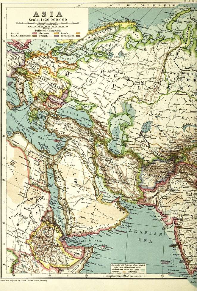
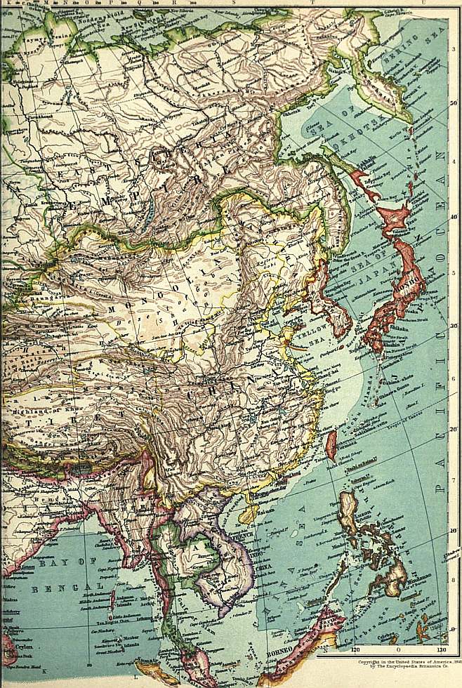
(Click to enlarge left side.) (Click to enlarge right side.)
The Laccadives and Maldives are groups of small coral islands, situated along the 73rd meridian at no great distance from the Indian peninsula on which they have a political dependency.
The portion of Asia west of British India excluding Arabia and Syria forms another extensive plateau covering an area as large as that of Tibet though at a much lower altitude. Its southern border runs along the Arabian Sea, the Persian The Nearer East. Gulf, the Tigris and thence westward to the north-east angle of the Levant, on the north the high land follows nearly 36° N. to the southern shore of the Caspian and thence to the Black Sea and Sea of Marmora. Afghanistan, Baluchistan, Iran or Persia, Armenia and the provinces of Asia Minor occupy this high region with which they are nearly conterminous. The eastern flank of this table-land follows a line of hills drawn a short distance from the Indus between the mouth of that river and the Himalaya, about on the 72nd meridian, these hills do not generally exceed 4000 or 5000 ft. in elevation but a few of the summits reach 10,000 ft. or more. The southern and south western face follows the coast closely up the Persian Gulf from the mouth of the Indus, and is formed farther west by the mountain scarp, which, rising in many points to 10,000 ft. flanks the Tigris and the Mesopotamian plains, and extends along Kurdistan and Armenia nearly to the 40th meridian, beyond which it turns along the Taurus range, and the north eastern angle of the Mediterranean. The north eastern portion of the Afghan table-land abuts on the Himalaya and Tibet, with which it forms a continuous mass of mountain between the 71st and 72nd meridians and 34° and 36° N. From the point of intersection of the 71st meridian with the 36th parallel of latitude, an unbroken range of mountain stretches on one side towards the north east, up to the crest of the northern slope of the Tibetan plateau, and on the other nearly due west as far as the Caspian. The north eastern portion of this range is of great altitude, and separates the headwaters of the Oxus, which run off to the Aral Sea, from those of the Indus and its Kabul tributary, which, uniting below Peshawar are thence discharged southward into the Arabian Sea. The western part of the range, which received the name of Paropamisus Mons from the ancients, diminishes in height west of the 65th meridian and constitutes the northern face of the Afghan and Persian plateau rising abruptly from the plains of the Turkoman desert which lies between the Oxus and the Caspian. These mountains at some points attain a height of 10,000 or 12,000 ft. Along the south coast of the Caspian this line of elevation is prolonged as the Elburz range (not to be confused with the Elburz of the Caucasus), and has its culminating point in Demavend, which rises to 19,400 ft. above the sea thence it extends to the north west to Ararat, which rises to upwards of 17,000 ft. from the vicinity of which the Euphrates flows off to the south west across the high lands of Armenia. Below the north east declivity of this range lies Georgia, on the other side of which province rises the Caucasus, the boundary of Asia and Europe between the Caspian and Black Seas, the highest points of which reach an elevation of nearly 19,000 ft. West of Ararat high hills extend along the Black Sea between which and the Taurus range lies the plateau of Asia Minor reaching to the Aegean Sea, the mountains along the Black Sea, on which are the Olympus and Ida of the ancients rise to 6000 or 7000 ft., the Taurus is more lofty—reaching 8000 and 10,000 ft.—both ranges decline in altitude as they approach the Mediterranean.
This great plateau extending from the Mediterranean to the Indus has a length of about 2500 m. from east to west, and a breadth of upwards of 600 m. on the west and nowhere of less than 250 m. It lies generally at altitudes between 2000 ft. and 8000 ft. above the sea level. Viewed as a whole the eastern half of this region, comprising Persia, Afghanistan and Baluchistan, is poor and unproductive. The climate is very severe in the winter and extremely hot in summer. The rainfall is very scanty, and running waters are hardly known excepting among the mountains which form the scarps of the elevated country. The population is sparse, frequently nomadic, and addicted to plunder, progress in the arts and habits of civilization is small. The western part of the area falls within the Turkish empire. Its climate is less hot and and its natural productiveness much greater and its population more settled and on the whole more advanced.
The peninsula of Arabia with Syria, its continuation to the north-west, has some of the characteristics of the hottest and driest parts Persia and Baluchistan. Excepting the northern part of this tract which is conterminous with the plain of Arabia. Mesopotamia (which at its highest point reaches an elevation of about 700 ft. above the sea) the country is covered with low mountains, rising to 3000 or 4000 ft. in altitude having among them narrow valleys in which the vegetation is scanty with exceptional regions of greater fertility in the neighbourhood of the coasts where the rainfall is greatest. In northern Syria the mountains of Lebanon rise to about 10,000 ft. and with a more copious water supply the country becomes more productive. The whole tract, excepting south eastern Arabia is nominally subject to Turkey but the people are to no small extent practically independent living a nomadic pastoral and freebooting life under petty chiefs in the more arid districts, but settled in towns in the more fertile tracts where agriculture becomes more profitable and external commerce is established.
The area between the northern border of the Persian high lands and the Caspian and Aral Seas is a nearly desert low lying plain, extending to the foot of the north-western extremity of the great Tibeto-Himalayan mountains and prolonged eastward Trans-Caspian region and central Asia. up the valleys of the Oxus (Amu Darya) and Jaxartes (Syr-Darya), and northward across the country of the Kirghiz to the south western border of Siberia. It includes Bokhara, Khiva and Turkestan proper in which the Uzbeg Turks are dominant, and for the most part is inhabited by nomadic tribes, who are marauders, enjoying the reputation of being the worst among a race of professed robbers. The tribes to the north, subject to Russia, are naturally more peaceable, and have been brought into some degree of discipline. In this tract the rainfall is nowhere sufficient for the purposes of agriculture, which is only possible by help of irrigation, and the fixed population (which contains a non-Turkish element) is comparatively small, and restricted to the towns and the districts near the rivers.
The north-western extremity of the elevated Tibeto-Himalayan mountain plateau is situated about on 73° E. and 39° N. This region is known as Pamir, it has all the characteristics of the highest regions of Tibet, and so far fitly receives the Russian designation of steppe, but it seems to have no special peculiarities, and the reason of its having been so long regarded as a geographical enigma is not obvious. From it the Oxus, or Amu, flows off to the west, and the Jaxartes, or Syr, to the north, through the Turki state of Khokand, while to the east the waters run down past Kashgar to the central desert of the Gobi, uniting with the streams from the northern slope of the Tibetan plateau that traverse the principalities of Yarkand and Khotan, which are also Turki. Here the Tibetan mountains unite with the line of elevation which stretches across the continent from the Pacific, and which separates Siberia from the region commonly spoken of under the name of central Asia.
A range of mountains, called Stanovor, rising to heights of 4000 or 5000 ft., follows the southern coast of the eastern extremity of Asia from Kamchatka to the borders of Manchuria, as far as the 135th meridian, in lat. 55° N. Thence the Yablonoi Manchuria. range, continuing in the same direction, divides the waters of the river Lena, which flows through Siberia into the Arctic Sea, from those of the river Amur, which falls into the North Pacific, the basin of this river, with its affluents, constitutes Manchuria. From the north of Manchuria the Khingan range stretches southward to the Chinese frontier near Peking, east of which the drainage falls into the Amur and the Yellow Sea, while to the west is an almost rainless region, the inclination of which is towards the central area of the continent, Mongolia.
From the western end of the Yablonoi range, on the 115th meridian, a mountainous belt extends along a somewhat irregular line to the extremity of Pamir, known under various names in its different parts, and broken up into several branches, Mongolia. enclosing among them many isolated drainage areas, from which there is no outflow, and within which numerous lakes are formed. The most important of these ranges is the Tian-shan or Celestial Mountains, which form the northern boundary of the Gobi desert, they lie between 40° and 43° N., and between 75° and 95° E., and some of the summits are said to exceed 20,000 ft. in altitude, along the foot of this range are the principal cultivated districts of central Asia, and here too are situated the few towns which have sprung up in this barren and thinly peopled region. Next may be named the Ala-tau, on the prolongation of the Tian-shan, flanking the Syr on the north, and rising to 14,000 or 15,000 ft. It forms the barrier between the Issyk-kul and Balkash lakes, the elevation of which is about 5000 ft. Last is the Altai, near the 50th parallel, rising to 10,000 or 12,000 ft., which separates the waters of the great rivers of western Siberia from those that collect into the lakes of north-west Mongolia, Dzungaria and Kalka. A line of elevation is continued west of the Altai to the Ural Mountains, not rising to considerable altitudes; this divides the drainage of south-west Siberia from the great plains lying north east of the Aral Sea.
The central area bounded on the north and north-west by the Yablonoi Mountains and their western extension in the Tian-shan, on the south by the northern face of the Tibetan plateau and on the east by the Khingan range before alluded to, forms the great desert of central Asia, known as the Gobi. Its eastern part is nearly conterminous with south Mongolia, its western forms Chinese or eastern Turkestan. It appears likely that no part of this great central Asiatic desert is less than 2000 ft. above the sea level. The elevation of the plain about Kashgar and Yarkand is from 4000 to 6000 ft. The more northern parts of Mongolia are between 4000 and 6000 ft., and no portion of the route across the desert between the Chinese frontier and Kiakhta is below 3000 ft. The precise positions of the mountain ridges that traverse this central area are not properly known, their elevation is everywhere considerable, and many points are known to exceed 10,000 or 12,000 ft.
In Mongolia the population is essentially nomadic, its wealth consisting in herds of horned cattle, sheep, horses and camels. The Turki tribes, occupying western Mongolia, are among the least civilized of human beings, and it is chiefly to their extreme barbarity and cruelty that our ignorance of central Asia is due. The climate is very severe, with great extremes of heat and cold. The drought is very great, rain falls rarely and in small quantities. The surface is for the most part a hard stony desert, areas of blown sand occurring but exceptionally. There are few towns or settled villages, except along the slopes of the higher mountains, on which the rain falls more abundantly, or the melting snow supplies streams for irrigation. It is only in such situations that cultivated lands are found, and beyond them trees are hardly to be seen.
The portion of Asia which lies between the Arctic Ocean and the mountainous belt bounding Manchuria, Mongolia and Turkestan on the north is Siberia. It includes an immense high and broken plateau which spreads from south-west to Siberia. north-east, losing in width and altitude as it advances north-east. It is fringed on either side by high border ridges, which subside on the north-west into a stretch of high plains, 1500 to 2000 ft. high, finally dropping to lowlands a few hundred feet above sea-level. The extremes of heat and cold are very great. The rainfall, though not heavy, is sufficient to maintain such vegetation as is compatible with the conditions of temperature, and the surface is often swampy or peaty. The mountain-sides are commonly clothed with pine forests, and the plains with grasses or shrubs. The population is very scanty; the cultivated tracts are comparatively small in extent and restricted to the more settled districts. The towns are entirely Russian. The indigenous races are nomadic Mongols, of a peaceful character, but in a very backward state of civilization. The Ural Mountains do not exceed 2000 or 3000 ft. in average altitude, the highest summits not exceeding 6000 ft., and one of the passes being as low as 1400 ft. In the southern half of the range are the chief mining districts of Russia. The Ob, Yenisei and Lena, which traverse Siberia, are among the largest rivers in the world.
The southern group of the Malay Archipelago, from Sumatra to Java and Timor, extends in the arc of a circle between 95° and 127° E., and from 5° to 10° S. The central part of the Malay Archipelago. group is a volcanic region, many of the volcanoes being still active, the summits frequently rising to 10,000 ft. or more.
Sumatra, the largest of the islands, is but thinly peopled; the greater part of the surface is covered with dense forest, the cultivated area being comparatively small, confined to the low lands, and chiefly in the volcanic region near the centre of the island. Java is the most thickly peopled, best cultivated and most advanced island of the whole Eastern archipelago. It has attained a high degree of wealth and prosperity under the Dutch government. The people are peaceful and industrious, and chiefly occupied with agriculture. The highest of the volcanic peaks rises to 12,000 ft. above the sea. The eastern islands of this group are less productive and less advanced.
Borneo, the most western and the largest of the northern group of islands which extends between 110° and 150° E., as far as New Guinea or Papua, is but little known. The population is small, rude and uncivilized; and the surface is rough and mountainous and generally covered with forest except near the coast, to the alluvial lands on which settlers have been attracted from various surrounding countries. The highest mountain rises to nearly 14,000 ft., but the ordinary elevations do not exceed 4000 or 5000 ft.
Of Celebes less is known than of Borneo, which it resembles in condition and natural characteristics. The highest known peaks rise to 8000 ft., some of them being volcanic.
New Guinea extends almost to the same meridian as the eastern coast of Australia, from the north point of which it is separated by Torres Straits. Very little is known of the interior. The mountains are said to rise to 20,000 ft., having the appearance Pacific Islands. of being permanently covered with snow; the surface seems generally to be clothed with thick wood. The inhabitants are of the Negrito type, with curly or crisp and bushy hair; those of the west coast have come more into communication with the traders of other islands and are fairly civilized. Eastward, many of the tribes are barbarous savages.
The Philippine Islands lie between 5° and 20° N., between Borneo and southern China. The highest land does not rise to a greater height than 10,250 ft.; the climate is well suited for agriculture, and the islands generally are fertile and fairly cultivated, though not coming up to the standard of Java either in wealth or population.
Formosa, which is situated under the northern tropic, near the coast of China, is traversed by a high range of mountains, reaching nearly 13,000 ft. in elevation. On its western side, which is occupied by an immigrant Chinese population, are open and well-cultivated plains; on the east it is mountainous, and occupied by independent indigenous tribes in a less advanced state.
The islands of Japan, not including Sakhalin, of which half is Japanese, lie between the 30th and 45th parallels. The whole group is traversed by a line of volcanic mountains, some of which are in activity, the highest point being about 13,000 ft. above the sea. The country is generally well watered, fertile and well cultivated. The Japanese people have added to their ancient civilization and their remarkable artistic faculty, an adaptation of Western methods, and a capacity for progress in war and commerce, which single them out among Eastern races as a great modern world-force.
Exploration
The progress of geodetic surveys in Russia had long ago extended across the European half of the great empire, St Petersburg being connected with Tiflis on the southern slopes of the Caucasus by a direct system of triangulation carried out with the highest scientific precision. St Petersburg, again, is connected with Greenwich by European systems of triangulation; and the Greenwich meridian is adopted by Russia as the zero for all her longitude values. But beyond the eastern shores of the Caspian no system of direct geodetic measurements by first-class triangulation has been possible, and the surveys of Asiatic Russia are separated from those of Europe by the width of that inland sea. The arid nature of the trans-Caspian deserts has proved an insuperable obstacle to those rigorous methods of geodetic survey which distinguish Russian methods in Europe, so that Russian geography in central Asia is dependent on other means than that of direct measurement for the co-ordinate values in latitude and longitude for any given point. The astronomical observatory at Tashkent is adopted for the initial starting-point of the trans-Caspian triangulation of Russia; the triangulation ranks as second-class only, and now extends to the Pamir frontier beyond Osh. The longitude of the Tashkent observatory has been determined by telegraph differentially with Pulkova as follows:—
H. M. S.
In 1875 via Ekaterinburg and Omsk 2 35 52.151
In 1891 via Saratov and Orenburg 2 35 52.228
In 1895 via Kiev and Baku 2 35 51.997
With these three independent values, all falling within a range of 0S.25, it is improbable that the mean value has an error as large as 0S.10.
Exact surveys in Russia, based upon triangulation, extend as far east as Chinese Turkestan in longitude about 75° E. of Greenwich. In India geodetic triangulation furnishes Extent of exact surveys in Asia. the basis for exact surveys as far east as the eastern boundaries of Burma in longitude about 100° E.
The close of the 19th century witnessed the forging of the final links in the great geodetic triangulation of India, so far as the peninsula is concerned. Further geodetic connexion with the European systems remains to be accomplished. Since 1890 further and more rigorous application of the telegraphic method of determining longitudes differentially with Greenwich has resulted in a slight correction (amounting to about 2″ of arc) to the previous determination by the same method through Suez. This last determination was effected through four arcs as follows:—
I. Greenwich—Potsdam.
II. Potsdam—Teheran.
III. Teheran—Bushire.
IV. Bushire—Karachi.
Each arc was measured with every precaution and a multitude of observations. The only element of uncertainty was caused by the retardation of the current, which between Potsdam and Teheran (3000 m.) took 0S.20 to travel; but it is probable that the final value can be accepted as correct to within 0S.05.
The final result of this latest determination is to place the Madras observatory 2′ 27″ to the west of the position adopted for it on the strength of absolute astronomical determinations.
But while we have yet to wait for that expansion of principal triangulation which will bring Asia into connexion with Europe by the direct process of earth measurement, a topographical Connexion between Russian and Indian surveys. connexion has been effected between Russian and Indian surveys which sufficiently proves that the deductive methods employed by both countries for the determination of the co-ordinate values of fixed points so far agree that, for all practical purposes of future Asiatic cartography, no difficulty in adjustment between Indian and Russian mapping need be apprehended.
In connexion with the Indian triangulation minor extensions carried out on systems involving more or less irregularity have been pushed outwards on all sides. They reach through Afghanistan and Baluchistan to the eastern districts of Extension of geographical surveys. Persia, and along the coast of Makran to that of Arabia. They have long ago included the farther mountain peaks of Nepal, and they now branch outwards towards western China and into Siam. These far extensions furnish the basis for a vast amount of exploratory survey of a strictly geographical character, and they have contributed largely towards raising the standard of accuracy in Asiatic geographical surveys to a level which was deemed unattainable fifty years ago. There is yet a vast field open in Asia for this class of surveys. While at the close of the 19th century western Asia (exclusive of Arabia) may be said to have been freed from all geographical perplexity, China, Mongolia and eastern Siberia still include enormous areas of which geographical knowledge is in a primitive stage of nebulous uncertainty.
Of scientific geographical exploration in Asia (beyond the limits of actual surveys) the modern period has been so prolific that it is only possible to refer in barest outline to some of the principal expeditions, most of which have been directed either to Indian explorers. the great elevated table-land of Tibet or to the central depression which exists to the north of it. In southern Tibet the trans-Himalayan explorations of the native surveyors attached to the Indian survey, notably Pundits Nain Singh and Krishna, added largely to our knowledge of the great plateau. Nain Singh explored the sources of the Indus and of the Upper Brahmaputra in the years 1865-1867; and in 1874-1875 he followed a line from the eastern frontiers of Kashmir to the Tengri Nor lake and thence to Lhasa, in which city he remained for some months. Krishna’s remarkable journey in 1879-1882 extended from Lhasa northwards through Tsaidam to Sachu, or Saitu, in Mongolia. He subsequently passed through eastern Tibet to the town of Darchendo, or Tachienlu, on the high road between Lhasa and Peking, and on the borders of China. Failing to reach India through Upper Assam he returned to the neighbourhood of Lhasa, and crossed the Himalayas by a more westerly route. Both these explorers visited Lhasa.
In 1871-1873 the great Russian explorer, Nicolai Prjevalsky, crossed the Gobi desert from the north to Kansu in western China. He first defined the geography of Tsaidam, and mapped the hydrography of that remarkable region, from which Russian explorers. emanate the great rivers of China, Siam and Burma. He penetrated southwards to within a month’s march of Lhasa. In 1876 he visited the Lop Nor and discovered the Altyn Tagh range. In 1879 he followed up the Urangi river to the Altai Mountains, and demonstrated to the world the extraordinary physical changes which have passed over the heart of the Asiatic continent since Jenghiz Khan massed his vast armies in those provinces. He crossed, and named, the Dzungarian extension of the Gobi desert, and then traversed the Gobi itself from Hami to Sachu, which became a point of junction between his journeys and those of Krishna. He visited the sources of the Hwang-ho (Yellow river) and the Salween, and then returned to Russia. His fourth journey in 1883-1885 was to Sining (the great trade centre of the Chinese borderland), and thence through northern Tibet (crossing the Altyn Tagh to Lop Nor), and by the Cherchen-Keriya trade route to Khotan. From Khotan he followed the Tarim to Aksu.
Following Prjevalsky the Russian explorers, Pevtsov and Roborovski, in 1889-1890 (and again in 1894), added greatly to our knowledge of the topography of western Chinese Turkestan and the northern borders of Tibet; all these Russian expeditions being conducted on scientific principles and yielding results of the highest value. Among other distinguished Russian explorers in Asia, the names of Lessar, Annentkov (who bridged the Trans-Caspian deserts by a railway), P.K. Kozlov and Potanin are conspicuous during the 19th century.
Although the establishment of a lucrative trade between India and central Asia had been the dream of many successive Indian viceroys, and much had been done towards improving the approaches to Simla from the north, very little was Other explorations in central Asia. really known of the highlands of the Pamirs, or of the regions of the great central depression, before the mission of Sir Douglas Forsyth to Yarkand in 1870. Robert Barkley Shaw and George Hayward were the European pioneers of geography into the central dominion of Kashgar, arriving at Yarkand within a few weeks of each other in 1868. Shaw subsequently accompanied Forsyth’s mission in 1870, when Henry Trotter made the first maps of Chinese Turkestan. The next great accession to our knowledge of central Asiatic geography was gained with the Russo-Afghan Boundary Commission of 1884-1886, when Afghan Turkestan and the Oxus regions were mapped by Colonel Sir T.H. Holdich, Colonel St George Gore and Sir Adelbert Talbot; and when Ney Elias crossed from China through the Pamirs and Badakshan to the camp of the commission, identifying the great “Dragon Lake,” Rangkul, on his way. About the same time a mission, under Captain (afterwards Sir Willaim) Lockhart, crossed the Hindu Kush into Wakhan, and returned to India by the Bashgol valley of Kafiristan. This was Colonel Woodthorpe’s opportunity, and he was then enabled to verify the results of W.W. M‘Nair’s previous explorations, and to determine the conformation of the Hindu Kush. In 1885 Arthur Douglas Carey and Andrew Dalgleish, following more or less the tracks of Prjevalsky, contributed much that was new to the map of Asia; and in 1886 Captain (afterwards Sir Francis) Younghusband completed a most adventurous journey across the heart of the continent by crossing the Muztagh, the great mountain barrier between China and Kashmir.
It was in 1886-1887 that Pierre G. Bonvalot, accompanied by Prince Henri d’Orléans, crossed the Tibetan plateau from north to south but failed to enter Lhasa. In 1889-1891 the American traveller, W.W. Rockhill, commenced his Tibetan explorations. Tibetan journeys, and also attempted to reach Lhasa, without success. By his writings, as much as by his explorations, Rockhill has made his name great in the annals of Asiatic research. In 1891 Hamilton Bower made his famous journey from Leh to Peking. He, too, failed to penetrate the jealously-guarded portals of Lhasa; but he secured (with the assistance of a native surveyor) a splendid addition to our previous Tibetan mapping. In 1891-1892-1893 the gallant French explorer, Dutreuil de Rhins, was in the field of Tibet, where he finally sacrificed his life to his work; and the same years saw George N. (afterwards Lord) Curzon in the Pamirs, and St George Littledale on his first great Tibetan journey, accompanied by his wife. Littledale’s first journey ended at Peking; his second, in 1894-1895, took him almost within sight of the sacred walls of Lhasa, but he failed to pass inside. Greatest among modern Asiatic explorers (if we except Prjevalsky) is the brave Swede, Professor Sven Hedin, whose travels through the deserts of Takla Makan and Tibet, and whose investigations in the glacial regions of the Sarikol mountains, occupied him from 1894 to 1896. His is a truly monumental record. From 1896 to 1898 we find two British cavalry officers taking the front position in the list of Tibetan travellers-Captain M.S. Wellby of the 18th Hussars and Captain H. Deasy of the 16th Lancers, each striking out a new line, and rendering most valuable service to geography. The latter continued the Pamir triangulation, which had been carried across the Hindu Kush by Colonels Sir T.H. Holdich and R.A. Wahab during the Pamir Boundary Commission of 1895, into the plains of Kashgar and to the sources of the Zarafshan.
Since the beginning of the century the work of Deasy in western Tibet has been well extended by Dr M.A. Stein and Captain C. G. Rawling, who have increased our knowledge of ancient fields of industry and commerce in Turkestan and Tibet. Ellsworth Huntington threw new light on the Tian-shan plateau and the Alai range by his explorations of 1903; and Sven Hedin, between 1899 and 1902, was collecting material in Turkestan and Tibetan fields, and resumed his journeys in 1905-1908, the result being to revolutionize our knowledge of the region north of the upper Tsanpo (see Tibet). The mission of Sir Francis Younghusband to Lhasa in 1904 resulted in an extension of the Indian system of triangulation which finally determined the geographical position of that city, and in a most valuable reconnaissance of the valleys of the Upper Brahmaputra and Indus by Captains C.H.D. Ryder and C.G. Rawling.
Meanwhile, in the Farther East so rapid has been the progress of geographical research since the first beginnings of investigation into the route connexion between Burma and China in 1874 (when the brave Augustus Margary lost his life), that a Chinese explorations. gradually increasing tide of exploration, setting from east to west and back again, has culminated in a flood of inquiring experts intent on economic and commercial development in China, essaying to unlock those doors to trade which are hereafter to be propped open for the benefit of humanity. Captain William Gill, of the Indian survey, first made his way across China to eastern Tibet and Burma, and subsequently delighted the world with his story of the River of Golden Sand. Then followed another charming writer, E.C. Baber, who, in 1877-1878, unravelled the geographic mysteries of the western provinces of the Celestial empire. Mark Bell crossed the continent in 1887 and illustrated its ancient trade routes, following the steps of Archibald Colquhoun, who wandered from Peking to Talifu in 1881. Meanwhile, the acquisition of Burma and the demarcation of boundaries had opened the way to the extension of geographical surveys in directions hitherto untraversed. Woodthorpe was followed into Burmese fields by many others; and amongst the earliest travellers to those mysterious mountains which hide the sources of the Irrawaddy, the Salween and the Mekong, was Prince Henri d’Orleans. Burma was rapidly brought under survey; Siam was already in the map-making hands of James M’Carthy, whilst Curzon and Warrington Smyth added much to our knowledge of its picturesque coast districts. No more valuable contribution to the illustration of western Chinese configuration has been given to the public than that of C.C. Manifold who explored and mapped the upper basin of the Yang-tsze river between the years 1900 and 1904, whilst our knowledge of the geography of the Russo-Chinese borderland on the north-east has been largely advanced by the operations attending the Russo-Japanese war which terminated in 1905.
Turning our attention westwards, no advance in the progress of scientific geography is more remarkable than that recorded on the northern and north-western frontiers of India. Here there is little matter of exploration. It has rather been a Indian frontiers—Afghanistan, Baluchistan, Persia. wide extension of scientific geographical mapping. Afghan war of 1878-80; the Russo-Afghan Boundary Commission of 1884-1885; the occupation of Gilgit and Chitral; the extension of boundaries east and north of Afghanistan, and again, between Baluchistan and Persia—these, added to the opportunities afforded by the systematic survey of Baluchistan which has been steadily progressing since 1880—combined to produce a series of geographical maps which extend from the Oxus to the Indus, and from the Indus to the Euphrates.
In these professional labours the Indian surveyors have been assisted by such scientific geographers as General Sir A. Houtum Schindler, Captain H.B. Vaughan and Major Percy M. Sykes in Persia, and by Sir George Robertson and Cockerill in Kafiristan and the Hindu Kush.
In still more western fields of research much additional light has been thrown since 1875 on the physiography of the great deserts and oases of Arabia. The labours of Charles Doughty and Wilfrid S. Blunt in northern Arabia in 1877-1878 were Arabia. followed by those of G. Schweinfurth and E. Glaser in the south-west about ten years later. In 1884-1885 Colonel S.B. Miles made his adventurous journey through Oman, while Theodore Bent threw searchlights backwards into ancient Semitic history by his investigations in the Bahrein Islands in 1888 and in Hadramut in 1894-1895.
In northern Asia it is impossible to follow in detail the results of the organized Russian surveys. The vast steppes and forest-clad mountain regions of Siberia have assumed a new geographical aspect in the light of these revelations, and Northern Asia, Siberia, &c. already promise a new world of economic resources to Russian enterprise in the near future. A remarkable expedition by Baron Toll in 1892 through the regions watered by the Lena, resulted in the collection of material which will greatly help to elucidate some of the problems which beset the geological history of the world, proving inter alia the primeval existence of a boreal zone of the Jurassic sea round the North Pole.
In no other period of the world’s history, of equal length of time, has so much scientific enterprise been directed towards the field of Asiatic inquiry. The first great result of recent geographical research has been to modify pre-existing ideas of General results of investigation. the orography of the vast central region represented by Tibet and Mongolia. The great highland plateau which stretches from the Himalaya northwards to Chinese Turkestan, and from the frontier of Kashmir eastwards to China, has now been defined with comparative geographical exactness. The position of Sachu (or Saitu) in Mongolia may be taken as an obligatory point in modern map construction. The longitude value now adopted is 94° 54′ E. of Greenwich, which is the revised value given by Prjevalsky in the map accompanying the account of his fourth exploration into central Asia. Other values are as follows:—
Prjevalsky, by his second and third explorations 94° 26′
Krishna 94° 23′
Carey and Dalgleish 94° 48′
Littledale 94° 49′
Kreitner (with Szecheny’s expedition) 94° 58′
The longitude of Darchendo, or Tachienlu, on the extreme east, may be accepted as another obligatory point. The adopted value by the Royal Geographical Society is 102° 12″. Krishna gives 102° 15″, Kreitner 102° 5″, Baber 102° 18″.
South and west the bounding territories are well fixed in geographical position by the Indian survey determinations of the value of Himalayan peaks. On the north the Chinese Turkestan explorations are now brought into survey connexion with Kashmir and India.
No longer do we regard the Kuen-lun mountains, which extend from the frontiers of Kashmir, north of Leh, almost due east to the Chinese province of Kansu, as the southern limit of the Gobi or Turkestan depression. This very remarkable longitudinal chain is undoubtedly the northern limit of the Chang Tang, the elevated highland steppes of Tibet; but from it there branches a minor system to the north-east from a point in about 83° E. longitude, which culminates in the Altyn Tagh, and extends eastwards in a continuous water-divide to the Nan Shan mountains, north of the Koko Nor basin. Thus between Tibet and the low-lying sands of Gobi we have, thrust in, a system of elevated valleys (Tsaidam), 8000 to 9000 ft. above sea-level, forming an intermediate steppe between the highest regions and the lowest, east of Lop Nor. All this is comparatively new geography, and it goes far to explain why the great trade routes from Peking to the west were pushed so far to the north.