NOTES ON THE ARCHEOLOGY OF THE WESTERN ESKIMO REGION
Reading edition
Archeological work in the vast area of the western Eskimo is still in its infancy. Until the 1926 Smithsonian expedition nothing whatever had been done in this line in the Eskimo parts of the southwestern coasts of Alaska[46] or on the Kuskokwim or Yukon Rivers.
Some time between 1877 and 1881 E. W. Nelson made limited excavations on St. Michael Island[47] (see p. 170) and also dug on Whale Island.
In 1912 V. Stefánsson excavated at Barrow.[48] Having two months to spend at this place he engaged numerous Eskimo of the village and had them excavate the native village sites in the neighborhood. He says (p. 388): "It was a small army that turned out to dig wherever there was a ruin or a kitchen midden, and they worked energetically and well. While the excavations were not done as methodically and scientifically as could have been wished, still we were able to get from them a collection of over 20,000 archaeological specimens within the space of six weeks. This collection (which is now safely stored in the American Museum of Natural History) brings out many significant and some revolutionary ideas with regard to the prehistoric history of the Eskimo. My method was to dig as much as possible myself, and to go around as best I could to see the others at work. In many cases I was able to see the exact position from which the important finds were taken." The specimens have since in part been described by Wissler.[49] Stefánsson brought also some archeological specimens from Point Hope, where, however, no excavations were made; and collected a valuable series of crania from Point Barrow.
In 1917-19 excavations near Barrow were conducted by W. B. Van Valin, leader of the John Wanamaker expedition to northwestern Alaska, for the University Museum at Philadelphia. The excavations were made in some mounds located about 8 miles southwest of Barrow and about 1,000 yards back from the beach on the tundra, and uncovered six old igloos containing, aside from many cultural objects, the skeletal remains of 83 individuals. These remains have since been found to be those of an intrusive group of people and to be of special interest.[50]
In 1924 Rasmussen during the last parts of his great journey gathered numerous archeological specimens at Point Hope and from other localities along the west coasts of Alaska.
In 1926, finally, the year of my survey, some careful initial excavations, with very interesting results, were carried on at Wales and on the Little Diomede Island by Dr. D. Jenness, of the National Museum of Canada, Ottawa. A preliminary report on the results of this work has been published in the annual report of the National Museum of Canada for 1926.
Besides such more professional work a good deal of archeological collection has been done in the regions under consideration by local people, particularly traders and teachers; and the demand for specimens has made assiduous excavators of some of the Eskimo themselves, particularly at Point Hope and at St. Lawrence Island.
Beginning with the north, the first white man to be mentioned in this connection is Charles Brower, the well-known trader at Barrow. Mr. Brower has not only aided all the explorers who have reached this northernmost point, but he has also been directly instrumental in excavating and the making of archeological collections, though, regrettably, some of these have been scattered.
During 1925-26 there lived at Point Hope a very active and interesting man, sent there by the Fox Film Co. to photograph the Eskimo—Mr. Merle La Voy. La Voy, whom I met at Point Hope and who for a time became our fellow-passenger on the Bear, had not only succeeded remarkably in his own line, but had also amassed during his stay a large archeological collection. He did not excavate himself, and unfortunately paid no attention to the scientific side of the case; but by offering the natives sugar, tea, chocolate, chewing gum, tobacco, etc. in exchange for specimens, he so stimulated them that they engaged most assiduously in the excavation, or rather picking over as they thawed, of their old ruins, and brought him thousands of objects, some of which are of considerable interest. At the time of my visit there were several barrels full of specimens, largely of stone and ivory. Skulls and bones, regrettably, were neglected and reburied in the débris. Later this collection was transported to San Francisco, where it remains at the date of this writing, in Mr. La Voy's possession.
At Kotzebue Mr. Tom Berryman, the trader, has made some collections of Eskimo archeological material, from which I benefited for the National Museum; and the local teacher, Mr. C. S. Replogle, informed me that he had a large collection at his home in the States.
At Nome I found a valuable lot of specimens in fossil ivory, pottery, and stone, in the possession of the well-known Lomen brothers, members of one of the foremost families in Alaska. The best parts of this collection I was fortunate to secure for exhibit in the United States National Museum.
A large and valuable collection of western Eskimo archeological material was made some years ago by Dr. Daniel Neuman. A part of this collection is in the museum at Juneau; the whereabouts of the rest and of Doctor Neuman himself I was unable to discover. There are several collections of archeological material from the western Eskimo region at Seattle and San Francisco, but none represents scientific excavation.
The names of Joe Bernard, Prof. H. N. Sverdrup, and O. W. Geist should be mentioned in this connection, all having collected archeological objects in the western Eskimo region. Many specimens of value collected by these men and others are in various museums or in private hands in Fairbanks, along the west coast or in Europe.
My own small part in the archeology of Bering Sea and the northwestern coast of Alaska was, as already stated, mainly that of making a survey of conditions. The object was to obtain a good general view of what there was in the line of archeological sites and remains, and thus help to lay a foundation for more organized research in the future. In addition all possible effort was made to collect and obtain specimens of distinct archeological value. Both of these endeavors met with results of some importance.
FOOTNOTES:
Old Sites in the Region of the Western Eskimo
The shores of the Alaska rivers, the littoral parts of Alaska, the more northern Bering Sea islands, and those portions of the Asiatic coast that were once or are still occupied by the Eskimo, are strewn with "dead" villages and old sites. Many of these dead villages or sites are historic, having been abandoned, or very nearly so, since the coming of the whites; some are older, in instances doubtless considerably older. Collectively they offer a large, almost wholly virginal and highly important field to American archeology. They may contain much of the secrets of Eskimo origin and of his cultural, as well perhaps as physical, evolution. But these secrets are not to be given up easily. They are held within a perpetually frozen ground, which on one hand preserves everything, but on the other will not yield its contents except to assiduous and prolonged labor.
Ruined or "dead" villages began to be encountered by the earliest Russian and other explorers. Beechey (1826) tells us that between approximately the latitude of Nelson Island and Point Barrow (60° 34´ to 71° 24´ N.) they noticed 19 (Eskimo) villages, some of which were very small and consisted only of a few huts, and others appeared to have been deserted a long time.[51]
Hooper, in 1884, reports Eskimo ruins on the Asiatic side:
"Near the extremity of the cape [Wankarem] we found the ruins of houses similar to those now in use by the Innuits, half underground, with frames of the bones of whales. Probably they were former dwellings of Innuits, who for some reason crossed the straits and attempted to establish themselves on the Siberian side. These houses have been found by different travelers at many places along this coast, and various causes assigned for the abandonment of the attempt to settle here by the Innuits. * * *
"At Cape Wankarem and at other places on the Siberian coast we found the ruins of houses similar to those now in use by the Innuits. These houses, which have been found by different travelers at many places along that coast, are not at all like those used by the Tchuktchis, which, on account of the migratory habits of the reindeer tribes, are so constructed that they can be taken down and put up again at will."[52]
Ray and Murdoch both speak of old sites. The very spot they selected for their observatory at Barrow was one of these. Ray says of it:
"A point about 12 feet above the sea level, lying between the sea and a small lagoon three-fourths of a mile northeast from Uglaamie, was finally selected. The soil was firm and as dry as any unoccupied place in that vicinity, and as it was marked by mounds of an ancient village would be free from inundation."[53]
And farther on:
"That the ancestors of those people have made it their home for ages is conclusively shown by the ruins of ancient villages and winter huts along the seashore and in the interior. On the point where the station was established were mounds marking the site of three huts dating back to the time when they had no iron and men 'talked like dogs'; also at Perigniak a group of mounds mark the site of an ancient village. It stands in the midst of a marsh; a sinking of the land causing it to be flooded and consequently abandoned, as it is their custom to select the high and dry points of land along the seashore for their permanent villages. The fact of our finding a pair of wooden goggles 26 feet below the surface of the earth, in the shaft sunk for earth temperatures, points conclusively to the great lapse of time since these shores were first peopled by the race of man."[54]
The village of Sidaru, southwest of Cape Belcher, which in Ray's time had a population of about 50, has since gone "dead."
The most direct attention to this subject has been given by Nelson. In his excellent large memoir on "The Eskimo about Bering Strait"[55] he states as follows:
"Ruins of ancient Eskimo villages are common on the lower Yukon and thence along the coast line to Point Barrow. On the Siberian shore they were seen from East Cape along the Arctic coast to Cape Wankarem....
"On the shore of the bay on the southern side of St. Michael Island I dug into an old village site where saucer-shape pits indicated the places formerly occupied by houses. The village had been burned, as was evident from the numerous fragments of charred timbers mixed with the soil. In the few cubic feet of earth turned up at this place were found a slate fish knife, an ivory spearhead, a doll, and a toy dish, the latter two cut from bark. The men I had with me from the village at St. Michael became so alarmed by their superstitious feelings that I was obliged to give up the idea of getting further aid from them in this place. I learned afterward that this village had been built by people from Pastolik, at the mouth of the Yukon, who went there to fish and to hunt seals before the Russians came to the country.
"On the highest point of Whale Island, which is a steep islet just offshore near the present village of St. Michael, were the ruins of a kashim and of several houses. The St. Michael people told me that this place was destroyed, long before the Russians came, by a war party from below the Yukon mouth. The sea has encroached upon the islet until a portion of the land formerly occupied by the village has been washed away. The permanently frozen soil at this place stopped us at the depth of about 2 feet. Here, and at another ancient Unalit village site which was examined superficially, we found specimens of bone and ivory carvings which were very ancient, as many of them crumbled to pieces on being exposed.
"Along the lower Yukon are many indications of villages destroyed by war parties. According to the old men these parties came from Askinuk and Kushunuk, near the Kuskokwim, as there was almost constant warfare between the people of these two sections before the advent of the Russians.
"Both the fur traders and the Eskimo claim that there are a large number of house sites on the left bank of the Yukon,[56] a few miles below Ikogmut. This is the village that the Yukon Eskimo say had 35 kashims, and there are many tales relating to the period when it was occupied. At the time of my Yukon trips this site was heavily covered with snow, and I could not see it; but it would undoubtedly well repay thorough excavation during the summer months. One of the traditions is that this village was built by people from Bristol Bay, joined by others from Nunivak Island and Kushunuk. One informant said that a portion of this village was occupied up to 1848, when the last inhabitant died of smallpox, but whether or not this is true I was unable to learn.
"Another informant told me that near the entrance of Goodnews Bay, near the mouth of the Kuskokwim, there is a circular pit about 75 feet in diameter, marking the former site of a very large kashim. A few miles south of Shaktolik, near the head of Norton Sound, I learned of the existence of a large village site. Both the Eskimo and the fur traders who told me of this said that the houses had been those of Shaktolik people, and that some of them must have been connected by underground passageways, judging from the ditch-like depressions from one to the other along the surface of the ground. The Shaktolik men who told me this said that there were many other old village sites about there and that they were once inhabited by a race of very small people who have all disappeared.
"From the Malemut of Kotzebue Sound and adjacent region I learned that there are many old village sites in that district. Many of these places were destroyed by war parties of Tinné from the interior, according to the traditions of the present inhabitants.
"On Elephant Point, at the head of the Kotzebue Sound, I saw the site of an old village, with about 15 pits marking the locations of the houses. The pits sloped toward the center and showed by their outlines that the houses had been small and roughly circular, with a short passageway leading into them, the entire structure having been partly underground.
"The Eskimo of East Cape, Siberia, said that there were many old village sites along the coast in that vicinity. These houses had stone foundations, many of which are still in place. There is a large ruined village of this kind near the one still occupied on the cape.
"On the extreme point of Cape Wankarem, and at its greatest elevation, just above the present camp of the Reindeer Chukchi, a series of three sites of old Eskimo villages were found."
To this, on pages 269 et seq., Nelson adds an account of the villages that "died" on St. Lawrence Island during the winter of 1879-80. Capt. C. L. Hooper, in the "Cruise of the Corwin in 1881, Notes and Observations" (published in Washington, 1884, p. 100) gives the date as 1878-79, and adds further details about these villages.
FOOTNOTES:
Present Location of Archeological Sites
Through personal visits, wherever possible, and through information from all available sources, an effort was made to locate and learn the character of as many of the old sites as could be traced. In this endeavor I was aided by many whose services are hereby gratefully acknowledged. Especial thanks are due to Captain Cochran with the officers and men of the Bear, particularly Boatswain H. Berg; to the Lomen brothers and their esteemed father, at Nome; to Father B. La Fortune and the Reverend Baldwin at Nome; to Mr. Sylvester Chance, superintendent of the northwestern district, Bureau of Education; to Mr. Charles D. Brower, trader at Barrow; to Mr. Jim Allen, trader at Wainwright; and to Dr. E. P. Walker, head of the Biological Survey of Alaska. The list to follow, supplemented by maps, will give in brief the name, location, and description of the remains.
The old sites occur, (1) in the form of refuse heaps; (2) as late village sites, smaller or larger areas of ground covered with mostly circular elevations and depressions, with occasionally the wooden remains of igloos or kashims, or only partly ruined dwellings; such remains are the most common; (3) as old village sites in the form of a long irregular ridge mound or of more or less separate heaps; (4) as heaps or "mounds" of individual structures. And as "passed" sites, covered completely by sand or silt and unknown until uncovered through the washing away by the sea or rivers of some of the deposits.
In addition there are the remains of burial grounds which are occasionally marked by small low mounds or hummocks produced by decayed burials that have been more or less assimilated by the tundra. Stony beaches with chips, implements, etc., such as are found off old sites on the Yukon, have not been seen in the region now dealt with in any instance.
The ruined dwellings and communal houses throughout this region, with a few minor exceptions, were of one general type. They were circular, yurta-shaped, semisubterranean structures, with a more or less subterranean tunnel approach, built of hewn driftwood and earth. These dwellings, when the wood decays and the dome falls in, leave characteristic saucer-and-handle-like depressions. But where such dwellings were close, and especially where they were heaped up or superimposed on older ones, the remains, together with the refuse, may form an irregular elevated ridge or a large irregular mound.
On the Diomede Islands the dwellings are built of stone, and ruins of stone houses have been reported to me from inland of the westernmost parts of the Seward Peninsula. Stone dwellings were also known on Norton Sound.
Some of the ridges and heaps, as at Shishmaref, Point Hope, one of the Punuk Islands, etc., are large and may be up to 15 feet and over in depth, but mostly the remains are of moderate to small size. The latter sometimes could easily be confounded with natural formations. The older remains may superficially be indistinguishable even to an experienced observer; and if there is anything still more ancient, it lies somewhere in the old sands and beaches where, except through some fortunate accident, it can not be discovered. Except for their surface, the remains are generally frozen hard, and no excavation is possible except through gradual exposure and the melting of layer after layer by the warmth of the sun or a melting of the ground with water or by some other artificial means.
Some at least of these ruins are rich archeologically. They greatly exceed in this respect a large majority of village ruins and mounds in the interior of the continent. This appears from their gradual excavation by the natives at Barrow, Point Hope, St. Lawrence Island, and elsewhere. The natives have now for many years been selling thousands of articles thus obtained to traders, teachers, and crews of visiting vessels. A regular and growing trade detrimental to archeology is now being carried on in "fossil ivory," which generally consists of pieces showing human workmanship and occasionally includes specimens of rare beauty and importance.
The archeological contents of such old sites as that near Savonga on the St. Lawrence Island, or those at Wales, Point Hope, Barrow, etc., are varied, and in instances exceedingly interesting. They comprise a large variety of objects of stone, ivory, bone, and wood, while in the more superficial layers are also found occasionally glass beads or objects of metal. Some ruins, such as those at Point Hope and Kotzebue, are very rich in stone objects; others, as those at the St. Lawrence Island, are rich in articles of ivory and bone. Pottery is generally scarce. Articles of stone comprise mainly points, knives, adzes, and lamps; those of wood, goggles and masks; of bone, various parts of sleds, a large assortment of snow and meat picks, and scrapers; of ivory, barbed points, harpoons, and lance heads, and a large variety of tools, fetishes, and ceremonial objects; of clay, a few dishes and pots for culinary purposes. Traces of objects made of whalebone or even birch bark may also appear.
The stones used were mainly slate and flint, but there may also be met with quartz, quartzite, and especially the Kobuk "jade." The workmanship is as a rule good to excellent. The arrow points show a number of interesting, not yet fully known, types, the long blade with parallel sides predominating. The stone lamps and rare dishes also need further study. The knives all approach the Asiatic semilunar variety.
The bones and wooden objects and the pottery from this region are fairly well covered by the writings of Ray, Murdoch, Nelson, Rau, Thomas, and others; the masks need further study.
The most interesting archeological specimens from the region of the western Eskimo, however, are some of those in "fossil ivory," the term being applied to walrus ivory that through long lying in the ground has assumed more or less of a pearly yellow, variegated, sepia-brown or black color. These objects are known as yet very imperfectly. They are scarce at and especially north of Point Hope, and again along the west coast south of Norton Sound. Their center of frequency comprises seemingly the St. Lawrence Island, some parts of the Asiatic coast, the Diomedes, and parts of the Seward Peninsula. But they occur at least up to Point Hope, while west of Bering Strait they are said to appear as far as the river Kolyma.
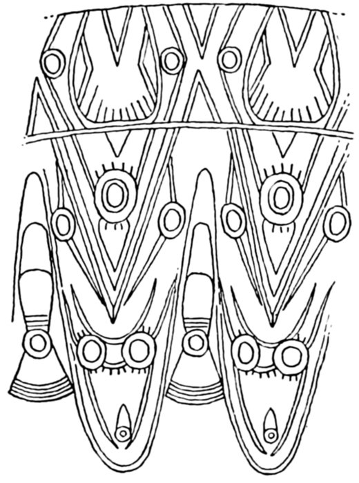
Figure 12.—Conventionalized design from fossil ivory specimen shown in Plate 19
Some of the objects in fossilized ivory show the well-known Eskimo art, with geometrical design. But besides these there occur here and there beautiful specimens, harpoon heads, figures, needle cases, etc., which are of the finest workmanship and which both in form and design differ from the prevailing Eskimo types. They are examples of high aboriginal art; and their engraved decorative lines are not geometrical but beautifully curvilinear. (Fig. 12.) The accompanying illustrations of specimens I succeeded in obtaining from different sources will show the nature of this art. (Pls. 19-26.) Isolated specimens of this nature have been secured before by Nelson, Neuman, Sverdrup, Stefánsson, and others. Jenness in 1926 dug out a few from the old sites at Wales. There are several in the Museum of the American Indian in New York. But the largest and best collection of these remarkable articles is now that of the United States National Museum.[57]
The large fossil ivory figure (20.3 cm. maximum length, pl. 26) collected by Mr. Carl Lomen and now in the National Museum is of special interest. It comes from the Asiatic side. It is a handsomely made piece, belonging in all probability to the high fossil ivory culture. Its peculiarity is the bi-bevel face, a face made by two planes rising to a median ridge. It is so far a unique specimen of its kind. But with the aid of Mr. H. W. Krieger, curator of ethnology, United States National Museum, we found similar bi-beveled faces in wooden figures from northeast Asia, in wooden Eskimo masks from the Yukon, and in wooden ceremonial figures from Panama. The latter are shown herewith. (Pl. 27.) The whole presents evidently a nice problem for the archeologist and student of culture.
BUREAU OF AMERICAN ETHNOLOGY FORTY-SIXTH ANNUAL REPORT PLATE 19
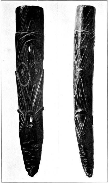
Terminal Piece of a Lance or Harpoon. Northern Bering Sea
Black, high natural polish. Most beautiful piece of the fossil ivory art. (A. H., 1926, U.S.N.M.)
BUREAU OF AMERICAN ETHNOLOGY FORTY-SIXTH ANNUAL REPORT PLATE 20
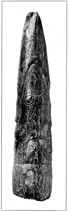
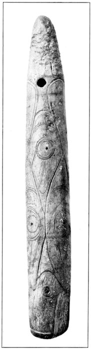
Fossil Ivory Specimens Showing the Old Curvilinear Designs. Northern Bering Sea
(A. H. coll., 1926, U.S.N.M.)
BUREAU OF AMERICAN ETHNOLOGY FORTY-SIXTH ANNUAL REPORT PLATE 21
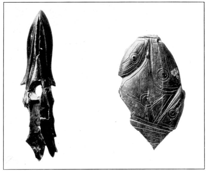
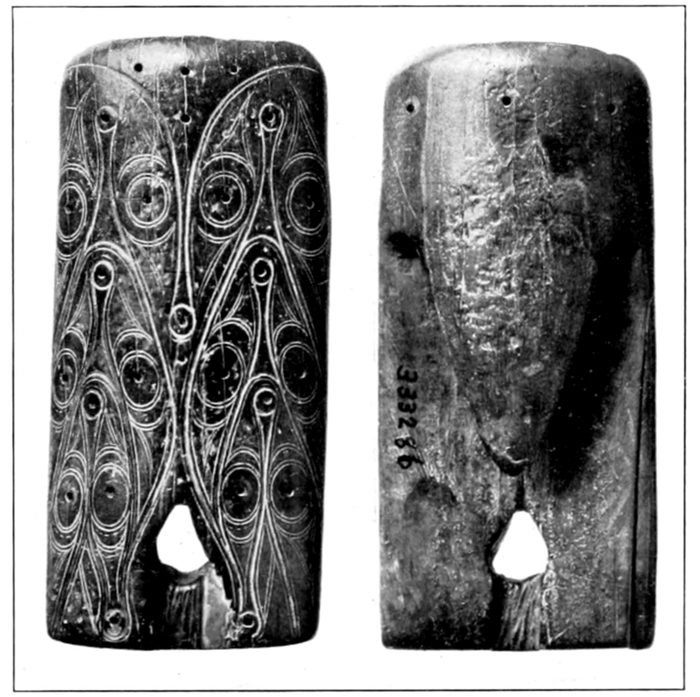
Objects Showing the Old Fossil Ivory Art. Northern Bering Sea
(U.S.N.M., Nos. 1 and 3, coll. A. H., 1926.)
BUREAU OF AMERICAN ETHNOLOGY FORTY-SIXTH ANNUAL REPORT PLATE 22
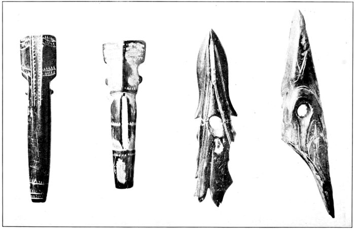
Fossil Ivory Needle Cases and Spear Heads, Northern Bering Sea, Showing Fine Workmanship
(A. H. coll., 1926, U.S.N.M.)
BUREAU OF AMERICAN ETHNOLOGY FORTY-SIXTH ANNUAL REPORT PLATE 23
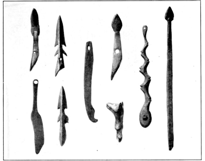
a, Small, finely made objects in fossil ivory and stone (the head), from the ruins at Port Hope (A. H. coll., 1926.)
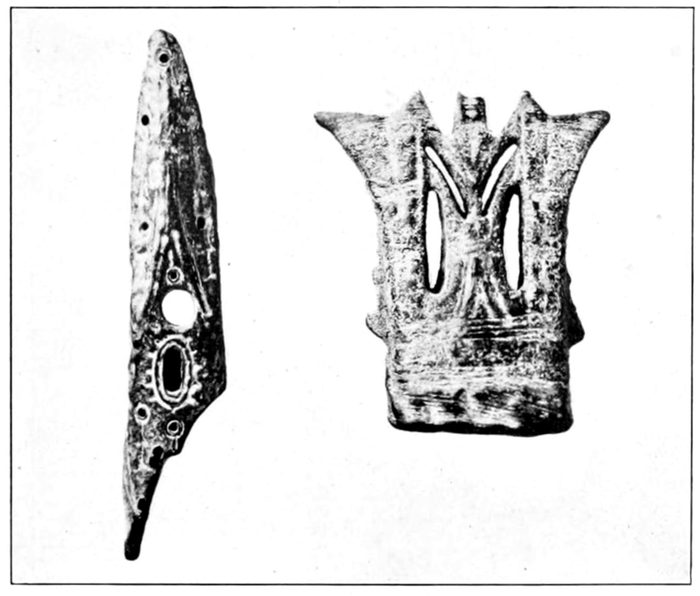
b, Old fossil ivory objects, northern Bering Sea. The article to the right is almost classic in form; it is decorated on both sides. (A. H. coll., 1926, U.S.N.M.)
BUREAU OF AMERICAN ETHNOLOGY FORTY-SIXTH ANNUAL REPORT PLATE 24
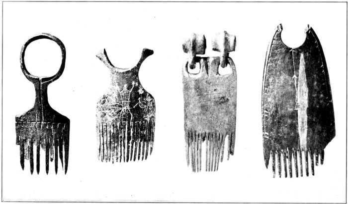
Fossil Ivory Combs. Upper Bering Sea
(A. H. coll., 1926)
BUREAU OF AMERICAN ETHNOLOGY FORTY-SIXTH ANNUAL REPORT PLATE 25
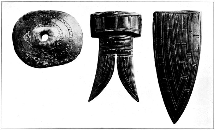
Fossil Ivory Objects From the Upper Bering Sea Region. Transitional Art
(Museum of the Agricultural College, Fairbanks, Alaska.)
BUREAU OF AMERICAN ETHNOLOGY FORTY-SIXTH ANNUAL REPORT PLATE 26
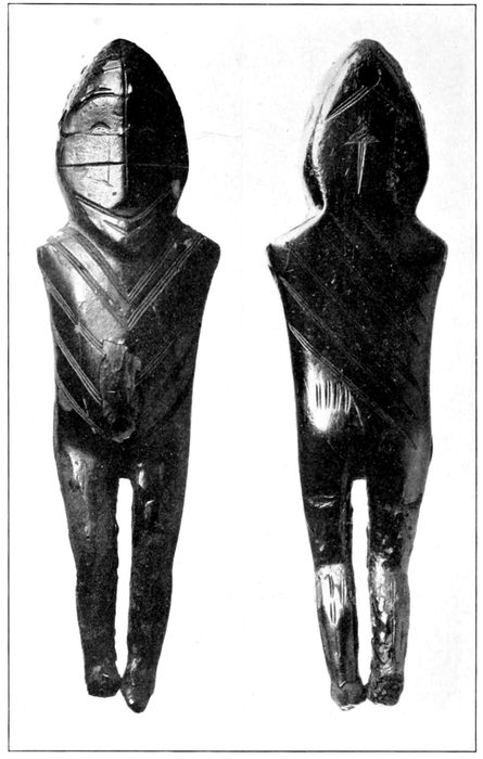
Old Black Finely Carved Fossil Ivory Figure, From the Northeastern Asiatic Coast
(Loan to U.S.N.M. by Mr. Carl Lomen.)
BUREAU OF AMERICAN ETHNOLOGY FORTY-SIXTH ANNUAL REPORT PLATE 27
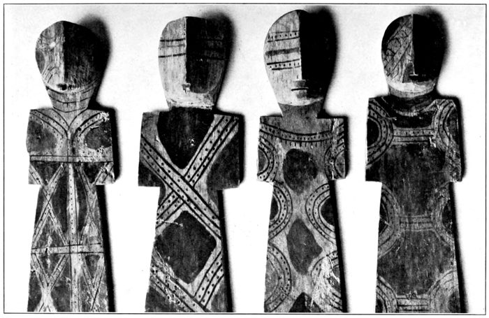
Wooden Figurines From a Medicine Lodge, Choco Indians, Panama
(U.S.N.M. colls.)
BUREAU OF AMERICAN ETHNOLOGY FORTY-SIXTH ANNUAL REPORT PLATE 28
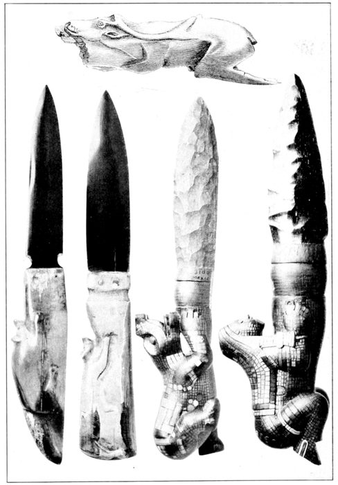
Top: Manche de poignard en ivoire, avec sculpture représentant un renne. Montastruc (Peccadeau de l'Isle; in de Quatrefages (A.), Hommes fossiles, Paris, 1884, p. 50)
Left: Two beautiful knives of fossil mammoth ivory lately made by a Seward Peninsula Eskimo. (Gift to the U.S.N.M. by A. H., 1926.)
Right: Two old ceremonial Mexican obsidian knives.
I had further the good fortune to secure, through the kindness of Reverend Baldwin, two handsome and remarkable knives from fossil mammoth ivory. These knives were said to have been made recently by the Eskimo of the Seward Peninsula. They are shown in Plate 28. They each bear on the handle a nicely carved crouching animal figure. With them are shown, somewhat more reduced, two probably ceremonial knives from Old Mexico; and also the handle of a late palaeolithic poignard from France, illustrated by De Quatrefages.[58] Regarding the latter form we read the following in Mortillet:[59] "D'autres poignées de poignard, faites dans des données pratiques et artistiques analogues, ont été recueillies dans diverses collections. Les plus remarquables sont deux poignées en ivoire trouvées par Peccadeau de l'Isle, à Bruniquel. L'une se rattachait à la lame, comme dans la pièce précédente, par le train de derrière; l'autre, au contraire, par la tête." Knives with similar crouching animal figures on the handle are being made by the King Islanders.
Here, evidently, is one more interesting problem for the archeologists.
The art shown by these objects, the conventionalization, and especially the decorations, appear to show affinity on one hand to deeper eastern Asia and on the other to those of the American northwest coast and even lower. This may prove to mean much or little. The fact that these specimens establish beyond question is that at one time and up to a few hundreds of years ago there existed in the lands of the northern Bering Sea native art superior to that existing there later and at the present, and comparable with the best native Siberian or American.
The meaning of this fact seems to me to be of importance. The evidence suggests, aside from other things, that American cultural developments may after all not have been purely local or even American, but that they may, in part at least, have been initiated or carried from Asia. In view of these and other recent developments it seems rational to consider that America may have been peopled by far eastern Asiatic groups that not merely carried with them differences in language and physique but also in some cases relatively high cultural developments. But these for the present are mere hypotheses.
There is no definite indication as yet that the people of the high fossil ivory art in the northern Bering Sea and neighboring parts were any others than the ancestors of the Eskimo. The skeletal remains from these regions, as will be shown later, rather support this view. But those ancestors may not yet have represented the characteristic present type of the people. Here, too, nothing definite can be said before the results of sufficient scientific excavations become available.
FOOTNOTES:
Sites and Villages
The location of the western Eskimo villages has received more or less attention by most of the explorers in their region from the Russian time onward; but such efforts are generally limited to the living villages in the area visited by the observers.
Perhaps the earliest Russian map of value in this connection on the Bering Sea region is that which I find in Billings and Gall's Voyage or "Putěshestvie" of 1791, printed in St. Petersburg 1811. The map bears no date, but is evidently quite early. It gives three villages on the western point and north coast of the Seward Peninsula, namely Kiemile (later Nykhta, now Wales), Chegliukh, and Tykiak. (Pl. 29.)
The most notable and valuable of the Russian contributions to this subject is that of Zagoskin. This refers to the period of 1842-1844 and is contained partly in his "Peshechodnaia Opis," etc. (St. Petersburg, 1847), but especially on his maps. There are, I find, two of these maps—the "Merkatorskaia Karta Časti Sieverozapadnago Berega Ameriky" and the "Merkatorskaia Generalnaia Karta Časti Rossijskich Vladěnii v Amerikě." I came across the first in one copy of Zagoskin's invaluable account, which should long ago have been translated into English, and the other in another copy. Part of the second is here reproduced. (Pl. 30.) Both bear the statement that they were made by Zagoskin as the result of his explorations on the Yukon in 1842-1844. The second ("general") map is much the clearer and richer. Both maps, but especially the second, give a good number of villages, especially about Norton Sound and along the southern shore of Seward Peninsula. The orthography differs somewhat on the two charts.
The Tebenkof Atlas of 1849 includes a remarkably good map of the St. Lawrence Island. As on other Russian maps it gives the Punuk Islands, that later are lost by most map makers, and indicates the location of what probably were all the living settlements of that time, except on the Punuk. (Fig. 27.)
Finally, in 1861, Tikhmenief, in his "Istoričeskoie Obozrenie" (history of Russian America) gives a detailed map with many locations of Eskimo villages.
The Aleutian Islands and Kodiak are excellently dealt with by Veniaminof and also Tikhmenief, though little special attention is given to the location of the settlements.
None of the Russian explorers, regrettably, report verbally on the deserted sites or ruins. But their registration and location of many villages that have since become "dead" is of much historical as well as anthropological value.
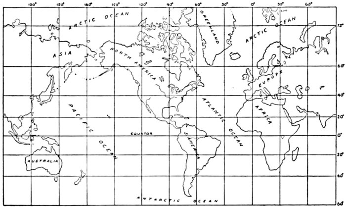
Figure 13.—World map
Of later and particularly American authors who gave attention to the location of the western Eskimo settlements, the foremost is E. W. Nelson. Beginning in 1877 with the St. Michael Island and ending with the cruise of the Corwin in 1881, Nelson made trips down the coast to the Kuskokwim, up the Yukon to Anvik, over the Bering Sea, the St. Lawrence Island and parts of the Chukchee Peninsula, and finally, with the Corwin, along the northern coasts to Point Barrow. And these journeys were devoted largely to biological and ethnological observations and collections, the latter including the location of the western Eskimo habitations of that time. His locations are given on the accompanying map (fig. 15) taken from his classic memoir, "The Eskimo about Bering Strait," published in 1900 in the Eighteenth Annual Report of the Bureau of American Ethnology. This memoir contains a section of "Ruins" (pp. 263-266), a brief account of the recently dead villages on St. Lawrence Island (p. 269), and an instructive section on Eskimo burials (pp. 310-322). Nelson brought also the first more substantial collection of Eskimo crania.
The next deserving man in these connections is Ivan Petrof. Of Russian-American extraction, Petrof was charged in 1880 with the census enumeration of the natives in Alaska, and he later published[60] a valuable report on his work, together with detailed demographic data and a map on which are given all the living settlements of his time. Nelson's map is partly based on Petrof's data.
Since Nelson and Petrof but little has been done in this field. But the maps of these two observers have been utilized more or less by the map makers of the United States Coast and Geodetic Survey, the Geological Survey, and other Government agencies concerned with Alaska. The result is that some of these charts are exceptionally useful to the anthropological explorer in Alaska; nevertheless the data they carry are incomplete and the locations or names are not always exact, a good many of the villages shown are now dead, and old ruins, as usual, have received no attention.
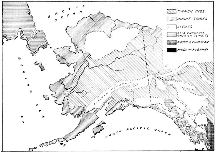
Figure 14.—Dall's map of the distribution of the tribes of Alaska and adjoining territory, 1875
A very valuable supplement to all the maps has in 1902 been published by the United States Geological Survey. It is the Geographic Dictionary of Alaska, by Marcus Baker. This volume, besides brief but serviceable historical data, gives in alphabetical order nearly all the then-known names of localities in Alaska, including those of the Eskimo and Indian settlements; and each name is accompanied by brief but in many instances most helpful information. This highly deserving volume, indispensable to every student of Alaska, has for many years been out of print, but it is understood that a new revised edition is slowly being prepared.
BUREAU OF AMERICAN ETHNOLOGY FORTY-SIXTH ANNUAL REPORT PLATE 29
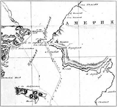
Billings and Gall's Map of Bering Strait and Neighboring Lands, 1811
BUREAU OF AMERICAN ETHNOLOGY FORTY-SIXTH ANNUAL REPORT PLATE 30
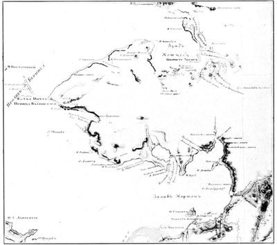
Eskimo Villages and Sites. Norton Sound and Bay and Seward Peninsula, and the Kotzebue Sound, from Zagoskin's General Map, 1847
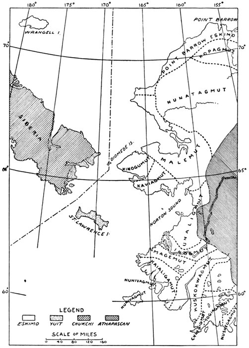
Figure 15.—Nelson's map. (Eighteenth Ann. Rept. Bur. Amer. Ethn., 1898)
Other useful publications in these connections are the United States Coast Pilots of Alaska, the various accounts of travelers, explorers, and men in collateral branches of science (geology, biology, etc.), the publications of the Alaska Division of the United States Department of Education, the annual reports of the Governor of Alaska, and the decennial reports on Alaska of the United States Census.
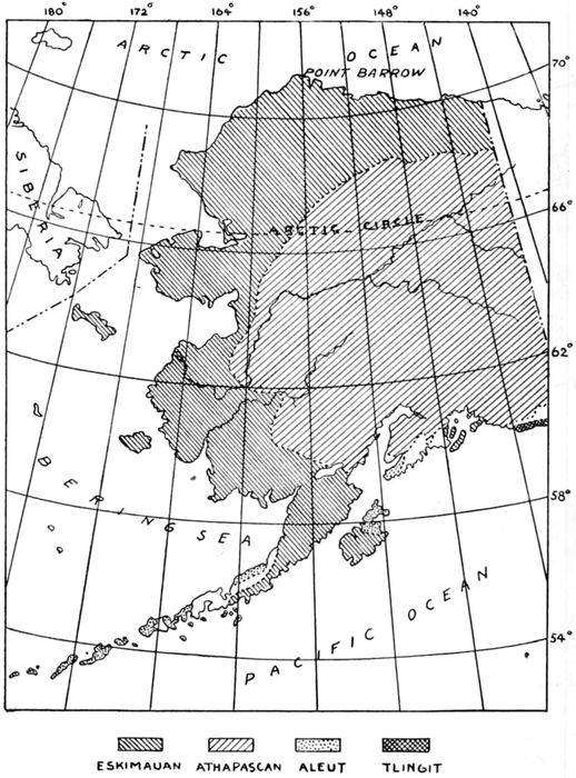
Figure 16.—Linguistic map, United States census, 1920
The object of the following notes and data is some measure of usefulness to future anthropological and archeological workers in Alaska. They are surely incomplete and very imperfect, yet they may be of some service.
Archeological and anthropological research in the highly important western Eskimo region is bound to develop in a not far distant future; for this is the region through which in all probability America was peopled. It is this region that promises to solve the problem of the antiquity of the Eskimo and may throw much light upon the origin of these people, and one that, as shown, above, has begun to reveal highly interesting old cultural conditions. And it is a region in which destruction of the remains by nature, but most so recently by the natives themselves, proceeds at an alarming pace.
The information on which these notes and the accompanying charts are based has been obtained largely from the Russian and other maps, from local traders, teachers, missionaries, and natives, and from a few explorers.[61] Only in a minority of cases was it possible to visit the places in person; to have visited all would have been a task of pleasure, but would have required a staunch boat of my own and at least three full seasons.
Many of the sites to be given are now "dead" and there may be several old sites in the vicinity of a living village. Others combine ruins with present habitations. Still others are partly or even wholly abandoned a part of the year when the inhabitants go camping or hunting, and are partly or wholly occupied during the rest of the year. Finally, there are some new settlements, with modern dwellings and ways, and their number will increase, the Eskimo taking kindly to civilization and individual property.
The data to be given here are limited to the Eskimo territory in southwestern and western Alaska, leaving out those in Siberia where much is uncertain. Due to the uncertainties of the Prince William Sound region they will begin with Kodiak Island. There are also on hand, principally due to Dr. E. P. Walker, numerous locations of old sites and villages in the Indian parts of southern and southeastern Alaska, but these will best be reserved for another occasion.
The Eskimo area will be roughly seen from the accompanying map published on the basis of the enumeration by the Fourteenth United States Census of 1920. A very great part of the territory allotted to the Eskimo, as well as that of the Indian, is barren of any population or its traces; the divisions represent the hunting grounds or grounds claimed by each people, not an occupied territory. The data will be given in south-to-north order.
Nearly all the settlements in these regions are now, and have evidently always been, on the shores of the seas and bays, as close to the water as safety would permit. A few villages and sites occur also, however, on inland lakes and rivers. The favored locations have been an elevated flat near the mouth of a fresh-water stream or the outlet of a lagoon, a sufficiently elevated spit projecting into the sea, or an elevated bar between the sea and an inland lake. The essentials were an elevated flat, a supply of fresh drinking water, and a location favorable for fishing and hunting; if there was some natural protection, so much the better. There were no inland settlements except on the lakes and rivers. In a few cases, as at the Kings and the Little Diomede Islands, very difficult locations were occupied only because outweighed by other advantages.
Caves throughout the occupied region north of the Aleutian chain are absent, and there was therefore no cave habitation.
None of the settlements were very large, though a few were much larger than others. They ranged from one or two family camps or houses to villages of some hundreds of inhabitants. A large majority of the settlements had from but two or three to approximately a dozen families.
There were two main types of dwellings, the semisubterranean sod houses for the winter and the skin tents for summer. In some places the two were near each other; in others the summer dwellings were in another and at times fairly distant locality.
The "zimniki" (in Russian) or winter houses were throughout the region of one general type. They were fair-sized circular semisubterranean houses, made of driftwood and earth, and provided with a semisubterranean entrance vestibule. Their remains are characterized everywhere by a circular pit with a short straight trench depression, the same pot-and-handle type as found along the Yukon. Rarely for the construction of the houses, where driftwood did not suffice, recourse was had to whale ribs and mandibles. The "letniki," or summer houses, were constructed on the surface of wood, sod and skins, or of whale ribs and skins, approaching on one hand the summer huts of various continental tribes and on the other the "yurts" of the north Asiatic peoples. The "kashims," or communal houses, were built, much as on the Yukon, like the family dwellings, but occasionally quadrilateral and much larger. Smaller semisubterranean storage houses of driftwood and sod near the winter dwellings were seemingly general.
Ruins of stone dwellings, without mortar, are said to exist in places on Norton Sound and Bay and on a lagoon near the western end of the Seward Peninsula. The few houses on the Little Diomede are made of loose unhewn stone slabs. The dwellings of the King Islanders are built on the rocky slope of the island on platforms supported by poles, all of driftwood.
There is as a rule an absence of separate refuse heaps near the villages. The refuse apparently has been dumped about and between the houses rather than on separate piles.
Dead villages abound. On consulting the older Russian records, however, it is seen that nearly all were still "living" as late as the early forties of the last century. Yet there are sites that were "dead" already when the Russians came, and the accumulations in other cases denotes a long occupation.
The site of a dead village, in summer, is generally marked by richer and greener vegetation; same as on the Yukon. The site itself is usually pitted or humped in a line forming a more or less elevated ridge, or the pits may be disseminated without apparently much order. And there may be irregular mound-like heaps without external traces of any structure.
In the older sites no trace of wood is visible; in the later rotten posts, crosspieces, parts of the covering of the house or tunnel, or even a whole habitation may be present. In the old sites the wood is hewn with stone axes; in the later it is sawed, and there may be nails.
Older accumulations lie occasionally beneath more recent ones, though no interruption of continuity may be traceable. Of a superposition of villages no trace was observable.
FOOTNOTES:
Burial Grounds
Due to the impossibility of digging sufficiently deep into the frozen ground the western Eskimo buried their dead near or on the surface or among rocks. Occasionally they utilized also, it seems, old dwellings for this purpose, and in more recent times at least the surface burials, wherever there was driftwood, would be protected by heavy rough-hewn planks put together in the form of boxes or by driftwood. They bear close fundamental resemblance to those of the Yukon. On the Nunivak Island occur graves made of rough stone slabs piled up without much order. (Pl. 31, a, b.)
Throughout the region the burials were located near the village, but the distance varied according to local conditions and habits. In some of the Eskimo villages of the lower Yukon, as at Old Hamilton, some burials were close to the houses of the living. In the Bering and Arctic regions the burial grounds, though sometimes of necessity not far from the houses, as at the Little Diomede, in other places, as at Point Hope and Barrow, were at a distance extending to beyond a mile and a half from the village.
As a rule the wood of burials older than about 80 years was found fully decayed with the bones secondarily buried. Of earlier burials there is generally no trace on the surface, but on excavation skeletal remains are found at various depths below the surface. These characteristic self-burials, or rather tundra burials, may prove of much importance to anthropology in the future. As outlined before (see Narrative, pp. 77, 79) the process is a decay of the wood; the sagging down of the bones, covered more or less by the decayed material; an encroachment of moss or other vegetation on the little mound thus produced; and gradual accumulation through wind or water carried materials of more covering over the bones, until the mound disappears and the remains, generally still in good condition, are buried as if intentionally inhumed.
The Eskimo everywhere were found to be exceedingly sensible about the older, and even recent, skeletal remains, and assisted readily in their collection, as well as in excavation, offering thus the best possible conditions for anthropological and archeological work in these regions.
The notes, charts, and a detailed list of the sites and villages follow. In numerous cases it was found impossible to say whether a site was completely "dead" or still occasionally partly occupied, so that distinctive markings had to be abandoned.
Prince William Sound, Kodiak Island, Alaska Peninsula
Very largely still a terra incognita for anthropology and archeology. Partly occupied by Indians (Prince William Sound, Kodiak Island?), partly by mix-blood Aleut (parts of Peninsula, and of Kodiak), partly by Eskimo. There is but little skeletal or archeological material from the whole extensive territory.
KODIAK ISLAND AND NEIGHBORHOOD [Fig. 17]
1. Litnik (probably the Russian "Lietnik," the name for a summer village).—Indian village on Afognak Bay, Afognak Island. This name is found on a map made by the Fish Commission in 1889. Apparently it is the Afognak of other maps (G. D. A.).[62]
2. Afognak.—On the southwestern part of Afognak Island. Village or row of scattered dwellings on shore of Afognak Bay, in southwestern part of Afognak Island. Population in 1890, 409. (G. D. A.) According to Walker, "an important, occupied native village which has probably been occupied for a long time. No doubt there are other native villages in this immediate vicinity."
3. Spruce Island.—Ouzinkie, or Uzinki; an occupied native village and cannery. (E. P. W.).[63]
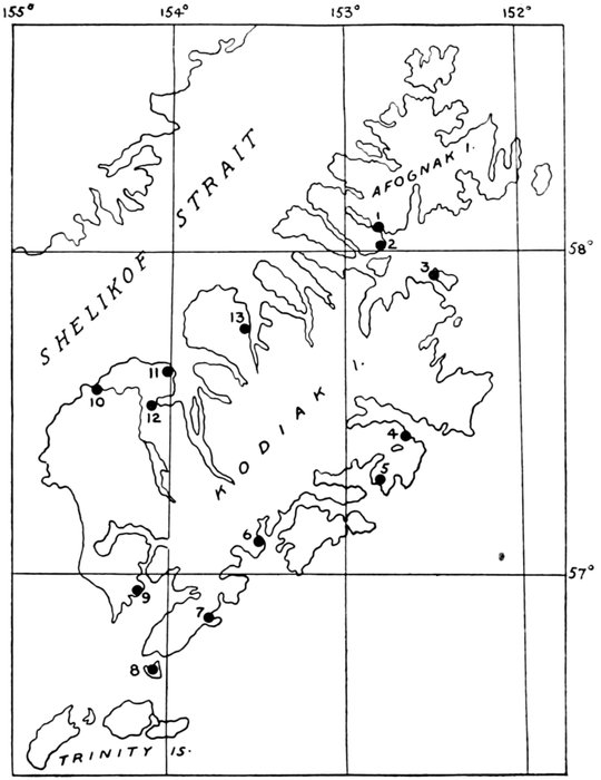
Figure 17.—Villages and sites on Kodiak Island
4. Eagle Harbour or Ugak Bay.—Possibly the native village "Orlova" of the Russians. (G. D. A.)
5. Kiliuda.—Native village, on the north shore of Kiliuda Bay, Kodiak. Has been generally written Killuda. (G. D. A.)
6. Nunamiut.—Native village, on the shore of Three Saints Harbor, Kodiak. (G. D. A.) Better known locally as Three Saints Bay. There was formerly an old native and Russian settlement at this point and vicinity, and fishing operations are frequently now conducted here. (E. P. W.)
7. Kaguyak.—Village, at Kaguyak Bay, on the southwestern shore of Kodiak. It may be identical with the Kaniag-miut of the Russian-American Co., in 1849. (G. D. A.) An old native village at present occupied by only one or two families. Possibly an old site. (E. P. W.)
8. Aiaktalik.—Village on one of the goose islands, near Kodiak. Population in 1890, 106. (G. D. A.) An occupied native village consisting of about a dozen houses, but which has probably been occupied for a long time. (E. P. W.)
9. Akhiok.—Native village on the northern shore of Alitak Bay, Kodiak. Native name from Petrof, 1880. Apparently identical with Oohaiack of Lisianski in 1805. (G. D. A.) An occupied native village consisting of about a couple of dozen houses. This or possibly other villages in the vicinity have undoubtedly been occupied for a long time. It is possible that there was a native settlement at Lazy Bay near this point, for Lazy Bay was formerly a native headquarters for sea otter hunting. (E. P. W.)
10. Karluk.—Village at mouth of Karluk River, Kodiak. Native name from the Russians. (G. D. A.)
11. Uyak.—Bay indenting the northwestern coast of Kodiak; also a village. Native name from the Russians. Lisianski, 1805, spells it Oohiack and the village Ooiatsk. Petrof, 1880, writes it Ooiak. Has also been written Uiak. (G. D. A.)
12. Larsen Bay.—A cannery has been located at this point for a number of years, and there is an old native trail from Larsen Bay to Karluk River, so presumably natives have frequented this section and no doubt have at some time had settlements there. Definite information regarding this is not available. (E. P. W.)
13. Uganik.—Native village at head of Uganik Bay. Shown by Lisianski, 1805, who spells it Oohanick. (G. D. A.) An occupied native village and one which has apparently been in use for a considerable period. (E. P. W.)
FOOTNOTES:
ALASKA PENINSULA [Figs. 18, 19]
Native settlements or old villages at one or more points in Kamishak Bay, Ursus Cove, or Iliamna Bay are reported, but there is nothing definite on the subject. (E. P. W.)
14. Iliamna.—An occupied native village, and undoubtedly there are various village sites on Iliamna Lake regarding which information could be obtained from parties in Iliamna. (E. P. W.)
15. Ashivak.—Native village (population 46 in 1880), near Cape Douglas, Cook Inlet. Native name reported by Petrof in 1880. (G. D. A.)
16. Kayayak.—Village, on Svikshak Bay, Shelikof Strait, about 25 miles southwest of Cape Douglas. Tebenkof, 1849, has Kaiaiak settlement, which has on many charts appeared as Kayayak. (G. D. A.)
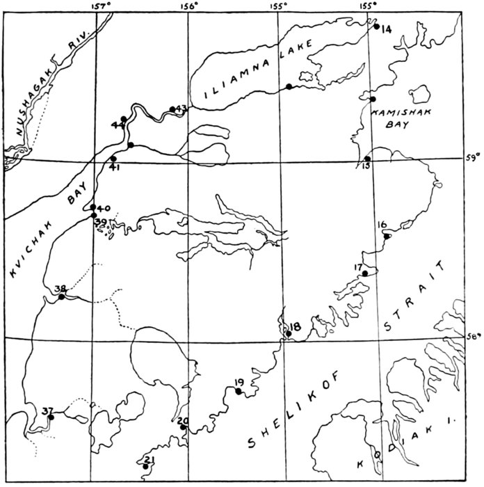
Figure 18.—Villages and sites on the proximal half of Alaska Peninsula
17. Kukak.—Native village on Kukak Bay. Lütke, 1835, has Koukak Bay and village. (G. D. A.)
18. Katmai.—Village, on Katmai Bay, Shelikof Strait, northwest of Kodiak. This is one of the most important of the native villages. Population in 1880, 218; in 1890, 132. (G. D. A.) A native village which was occupied up to the time of the Katmai eruption but was abandoned at that time. (E. P. W.)
19. Cold Bay.—Small village.
20. Kanatak.—A native village consisting of about half a dozen houses until in 1922, when oil activity in the vicinity caused a small white settlement to locate at this point. This, however, has since been almost entirely abandoned by whites. (E. P. W.)
21. Kuiukuk.—Small village.
22. Chignik.—Fishing station on Chignik Bay, Alaska Peninsula. Population in 1890, 193. (G. D. A.) There are three canneries in this immediate vicinity, a number of natives, and undoubtedly some native villages and probably old village sites. (E. P. W.)
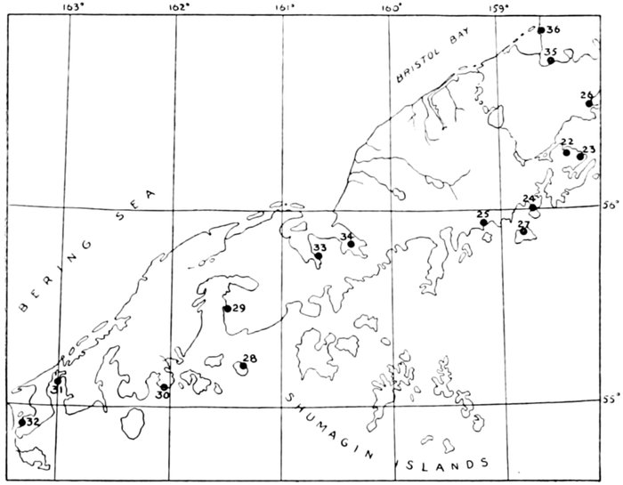
Figure 19.—Villages and sites on the distal half of Alaska Peninsula
23. Kaluiak.—Native village, on the southern shore of Chignik Bay, Alaska Peninsula. So given by Petrof in 1880 and the Fish Commission in 1888. (G. D. A.)
24. Mitrofania.—An old native village which has recently been abandoned or practically abandoned; was apparently a rather important village at one time. (E. P. W.)
25. Perryville.—A recently established native village consisting of natives from various points along the Alaska Peninsula who were moved there primarily by the Bureau of Education since the Katmai eruption. (E. P. W.)
26. Kujulik.—Walker has been informed that there is an old village site of that name either in this bay or on Kumlik.
27. Old village mentioned on this island; uncertain.
28. Wosnesenski.—An old village site on this island reported. (E. P. W.)
29. Pavlof.—Rev. D. Hotvoitzky, of Belkofski, informed Walker that there is a very old abandoned village site at the head of this bay.
30. Belkofski.—Bay, cape, and village on south coast of Alaska Peninsula. Named, by the Russians as early as 1835 and probably earlier. (G. D. A.) The most important occupied native village on the Alaska Peninsula. Quite an old village and a former headquarters for sea-otter hunting. (E. P. W.)
31, 32. Morzhovoi.—Native village at western end of Alaska Peninsula. Named Morzhovoi (Walrus) by the Russians. Variously spelled. There are or were two villages, one called Old Morzhovoi, the other New Morzhovoi, being about 12 miles apart. Old Morzhovoi was at the head of Morzhovoi Bay; New Morzhovoi is on Traders Cove, which opens into Isanotski Strait. The Greek church here is named Protassof, and Petrof, 1880, called the settlement Protassof. (G. D. A.) An occupied native village. The natives from this village also live during the canning season at the cannery in False Pass directly across the strait from Morzhovoi and at Ikatan a short way to the south. (E. P. W.)
33. Herendeen.—Walker has been informed that there are some shell mounds or kitchen middens about this bay. Walter G. Culver, formerly an employee of the Bureau of Education, but who is at present in Anchorage in care of the Alaska Railway, can give information regarding this and can also give information regarding most of the other native villages along the Alaska Peninsula. (E. P. W.)
34. Port Moller.—Eskimo site somewhere in this vicinity; name and exact location uncertain.
35. Unangashik.—A native village, or portage, near Port Heiden.
36. Meshik.—A village on Port Heiden.
37. Ugashik.—A native village on the Ugashik River. Reported by Petrof, 1880.
38. Igagik (or Egegik).—A village at the mouth of the Egegik River.
39. Kiniak (or Naknak, or Suvorof).—A village (of "Aleuts," Sarichef) at mouth of Naknak River, Bristol Bay, south side.
40. Pawik (or Pakwik).—Eskimo village, at mouth of Naknak River, Bristol Bay, north side.
41. Kogiunk.—Eskimo village at mouth of Kvichak River, Bristol Bay. Native name, reported in 1880 by Petrof, who spelled it Koggiung. (G. D. A.)
42. Lockanok.—Small village.
43. Kashanak.—Small old village.
44. Kvichak.—Old Eskimo village on river of same name between Kvichak Bay and Iliamna Lake.
Bristol Bay to Cape Romanzof
From the northern part of Bristol Bay to Cape Romanzof a partial survey of the coast was made in 1927 by Collins and Stewart (U. S. National Museum Expedition). In these regions and on the Nunivak Island it was possible to locate a series of villages some of which are still "living," others in ruins. In the late seventies of the last century, as stated before, the coast between Kuskokwim Bay and St. Michael Island was visited and its villages recorded by Nelson. A detailed archeological survey of this coast remains for the future. Doctor Romig, formerly a medical missionary at Bethel, told me of a number of old sites on the river. Some notes of interest by T. D. Stewart are given in the details. Mr. F. W. Bundy, for a time my companion on the Bear, told of an old site on the Kuskokwim. In March, 1927, H. W. Averill, writing from Bethel, tells of a deep-lying old site on the southern coast of the Kuskokwim Bay. (See details.) And later the same year Father Philip I. Delon, of the Holy Cross Mission, sent in three skulls from Kashunuk, in the Yukon delta, with information of much additional material in that locality.
45. Nushagak.—Old Russian post, "Alexandrovsk." Eskimo village, a few whites; a number of old native sites scattered about head of Nushagak Bay.
46. Ekuk.—Eskimo settlement near the mouth of Nushagak River. Name from Lütke, 1928, who spelled it Ekouk. Has also been written Yekuk. (G. D. A.)
46a. Reported site of Eskimo village.
47. Ualik.—Native village, on the western shore of Kulukak Bay, Bristol Bay, Bering Sea. Given by Petrof, 1880, as Ooallikh and by Spurr and Post as Oallígamut; i. e., Oallik people. (G. D. A.)
48. Togiak.—Old Eskimo settlement.
49. Ekilik.—Possibly the same as Togiakmute, reported in 1880 by Petrof. Eskimo village on the west bank of Togiak River, about 10 miles from its mouth. Eskimo name obtained by Spurr and Post, in 1898, who write it Ekilígamut; i. e., Ekilik people.
50. A small Eskimo village.
51. Mumtrak.—Eskimo village at head of Goodnews Bays, Bering Sea. Population in 1890, 162. Name from Petrof, 1880, who spelled it Mumtrahamute. (G. D. A.) Visited 1927 by Collins and Stewart; collections.
52. Site of a village, at junction of Bessie Creek and Arolic River.
53. Arolik.—A village. H. W. Averill of Bethel writes me under date of March 3, 1927, as follows: "I am sending you some old stone pieces that came from the Aralic River, a tributary of the lower Kuskokwim River, that were washed up by a bend in the river from an old village that is now 6 feet underground."
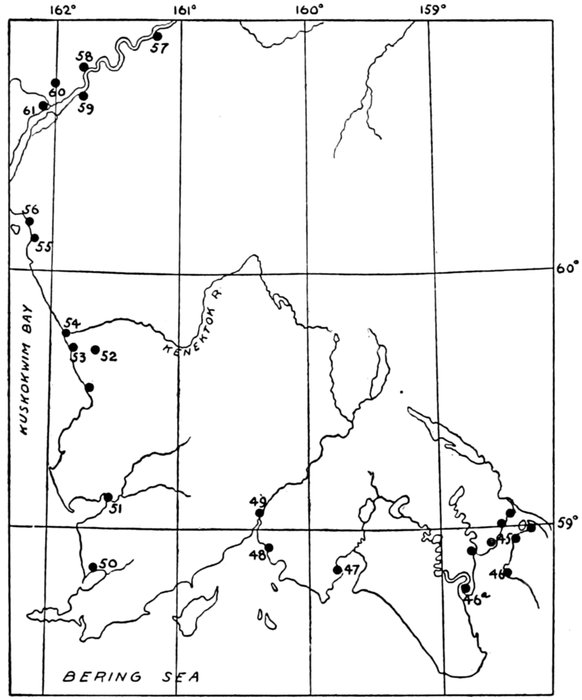
Figure 20.—Eskimo villages and sites on Nushagak Bay to Kuskokwim Bay
54. Kwinak.—Eskimo village on the eastern shore of Kuskokwim Bay, at the mouth of the Kwinak or Kanektok River, Bering Sea. So given by Sarichef, 1826, and Tebenkof, 1849. Petrof, 1880, writes it Quinehahamute, or, omitting the termination mute, meaning people, it would be Quene-a-ak. (G. D. A.)
55. Apokak.—Eskimo village on the eastern shore of Kuskokwim Bay, at the mouth of Apoka River. According to Nelson, 1878-79, its native name is Apokagamute; i. e., Apokak people. In the Eleventh Census, 1890, it is called Ahpokagamiut. (G. D. A.)
56. Eek.—Eskimo village at mouth of Eek River.
57. Akiak.—Eskimo village on the right bank of the Kuskokwim, about 30 miles above Bethel. Petrof, 1880, wrote its name Ackiagmute; i. e., Akiak people. Spurr and Post, 1898, write Akiagmut, following Missionary J. H. Kilbuck. (G. D. A.) Reindeer camps in vicinity.
58. Bethel.—White and Eskimo settlement and mission at or near the old Eskimo village Mumtrelega.
59. Napaiskak.—Eskimo village on the left bank of the Kuskokwim, about 4 miles below Bethel. According to Nelson, 1878-79, its native name is Napaskiagamute, and according to Missionary Kilbuck, 1898, it is Napaiskagamut; i. e., Napaiskak people.
60. Old sites.—Mr. Bundy, my companion for a time on the Bear, gives the following details: "Specimens found about 12 miles below Bethel, Alaska, at the mouth of the Kuskokwim River, beneath about 10 or 12 feet of alluvial soil deposits of sand and clay.
"Mr. Jack Heron, of Bethel, first noted the presence of old implements, and upon returning with him about August 1, 1923, we found the river had cut into the bank quite a bit and had brought to view, after the high waters had receded, additional specimens.
"Those found included: A large copper kettle of perhaps 8 gallons capacity of early Russian pattern, several arrowheads of slate or dark gray flint, and two spearheads of bone with several broken knife blades of slate and one or two small ivory ornaments resembling birds."
61. Napakiak.—Eskimo village on the right bank of the Kuskokwim, about 10 miles below Bethel. Nelson, 1878, reports the native name as Napahaiagamute. (G. D. A.)
62. Kinak.—Eskimo village on right bank of the lower Kuskokwim. Visited by Nelson in January, 1879, who reported its native name to be Kinagamiut; i. e., Kinak people. Its population was at that time about 175. Population in 1880, 60; 1890, 257. (G. D. A.)
63. Village site (?).
64. Kuskovak.—Eskimo village, on the right bank of the Kuskokwim River, near its mouth. Name from Nelson, who passed near it in January, 1879, and who writes it Kuskovakh. (G. D. A.)
65. Popokak.—Native village.
66. Kulvagavik.—Eskimo village, on the western side of Kuskokwim Bay, Bering Sea. Visited by Nelson in January, 1879, and its native name reported by him to be Koolvagavigamiut. (G. D. A.)
67. Kongiganak.—Eskimo village (of about 175 people in 1878) on north shore of Kuskokwim Bay. Visited by Nelson in December, 1878. (G. D. A.)
68. Anogok.—Eskimo village, on the mainland shore just west of Kuskokwim Bay, Bering Sea. Visited by Nelson in December, 1878. (G. D. A.)
69. Chalit.—Eskimo village, of about 60 people in 1878, on left bank of the Kuguklik River, northwest of Kuskokwim Bay. Visited by Nelson in December, 1878. (G. D. A.)
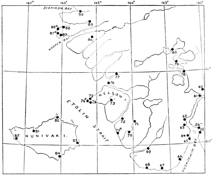
Figure 21.—Eskimo villages and sites, Kuskokwim Bay to Scammon Bay
70. Chichinak.—Eskimo village on the mainland, east of Nunivak Island, Bering Sea. Visited by Nelson in December, 1878. (G. D. A.)
70a. Old village site.
71. Sfaganuk.—Eskimo village, on the mainland, east of Nunivak Island, Bering Sea. Visited by Nelson in December, 1878. (G. D. A.)
72. Agiukchuk.—Eskimo village, on the mainland, east of Nunivak Island, Bering Sea. Visited by Nelson in December, 1878. (G. D. A.)
73. Kashigaluk.—Eskimo village, on Nelson Island, Bering Sea. Visited by Nelson in December, 1878. (G. D. A.)
74. Kaliukluk.—Eskimo village, on Nelson Island, near Cape Vancouver, Bering Sea. Visited by Nelson in December, 1878. (G. D. A.)
74a. Old village site.
75. Tanunak.—Eskimo village, at Cape Vancouver, Nelson Island, Bering Sea. Name from Nelson, who visited it in December, 1878. Visited 1927 by Collins and Stewart; collections.
75a. Village site.
76. Ukak.—Eskimo village, in the Yukon Delta, on shore of Hazen Bay. Visited by Nelson in December, 1878, and its name reported by him as Ookagamiut; i. e., Ukak people. Petrof, 1880, calls it Ookagamute. (G. D. A.)
77. Unakak.—Eskimo village, in the Yukon Delta, near Hazen Bay. Nelson, who visited it in December, 1878, reports its name to be Oonakagamute; i. e., Unakak people. Petrof, 1880, calls it Oonakagamute. (G. D. A.)
78. Kvigatluk.—Eskimo village, in the Big Lake country, between the Yukon and Kuskokwim. Nelson in 1879 passed near it and reports its name to be Kvigathlogamute. (G. D. A.)
79. Nunochok.—Eskimo village, in the Big Lake region. Visited by Nelson in January, 1879, who reports its native name to be Nunochogmute; i. e., Nunochok people.
80. Nanvogaloklak.—Eskimo village, in the Big Lake country. Visited by Nelson in January, 1879. Population in 1880, 100; in 1890, 107. (G. D. A.)
81. Nash Harbor.—Living village, Nunivak Island; school; Collins and Stewart, 1927, anthropometric data, collections (also from other parts of island).
82. Koot.—Village, Nunivak Island, near Cape Etolin; partly occupied. Population in 1890, 117.
83. Inger.—(In Eleventh Census: Ingeramiut.) Dead village, in southeast part of Nunivak Island. Population, 1890, 35.
84. Kvigak (or Kwik).—Dead village, southern part of Nunivak Island.
85. Tachikuga.—Dead village, Nunivak Island, below Cape Mohican.
86. Kashunuk.—Eskimo village; some collections; skeletal material in vicinity reported 1927 by Father Delon, of the Holy Cross Mission, Yukon.
87. Askinuk.—Eskimo village on the southern shore of Hooper Bay, Yukon Delta. Native name, from Nelson. Population 1878, 200. (G. D. A.)
87a. Village site.
88. Agiak.—Eskimo village on promontory north of Hooper Bay.
88a. Village site.
89. Igag.—Small village.
90. Kut (Kutmiut).—Small village on Kut River, head of Scammon Bay.
Cape Romanzof to Northern (Apoon) Pass of the Yukon and Northward
On this coast there is little information since the time of Nelson. There are a number of occupied villages as well as of old sites. The region is bleak and the Eskimo there are reported to live miserably.
The principal Eskimo villages and sites along the lowermost branch of the Yukon have been given previously. (Fig. 11.)
From the northernmost pass of the Yukon to St. Michael Island the coast is poor in Eskimo remains. A site of interest here is the old camping ground, with a few permanent houses, of Pastolik, and there are two small sites farther up the coast. Pastolik to the writer's visit was still occasionally occupied by a few Eskimo families. There are only three houses, but a relatively large and old cemetery speaks of a larger population, probably camping here in tents during the summer seasons of the past. The burial grounds were found to be rather extensive and give indications of containing human bones as well as artifacts below the present surface (buried by the tundra). The main part of the burial grounds may well repay an excavation.
St. Michael Island.—Eskimo remains exist on the northeastern point of the island beyond the present white man's village, and also on the rock (Whale Island) opposite this point. During my visit the ground was so overgrown by high weeds that details were hidden. On this same northeastern point near the extension of the white settlement is a small living Eskimo village, most of the inhabitants of which are now of mixed blood. Across St. Michael Bay are said to be some old traces of Eskimo, and Nelson reported an old site in the southern part of the island. Finally at Cape Stephens, in the western extremity of the island, there is "Stebbins," another living village. Nothing could be learned of any human remains on the opposite Stuart Island.
Norton Sound.—North of St. Michael Island is Norton Sound and Norton Bay. Along the east coast of the Sound there are three villages still occupied, but with old accumulations. It is reported that in this region there are some ruined houses in which mammoth tusks had been used in the construction, but nothing definite could be learned as to the location of these houses and the whole may be but a story. The village of Unalaklik was of importance in the past and its older remains would probably repay excavation. Old sites are reported from the vicinity of Shaktolik and at Cape Denbigh.
The Norton Bay region (fig. 22), now almost depopulated, had in 1840 a whole series of moderate-sized living Eskimo settlements, both on the east and the west shore. These shallows are but little visited, and it is probable that the remains of the villages and some at least of the skeletal material of their burying grounds are well preserved. They call for early attention.
To the west of Norton Bay, on the southern coast of Seward Peninsula, is Golovnin[64] Bay. On the eastern shore of this bay are now, as there were in Russian times, two settlements, but the name of one has been misplaced. On Zagoskin's map it is clearly seen that the village Ching or Chinig corresponds in location to what now is the mission, while what is now called "Cheenik" was in 1840 Ikalik or Ikalikhaig. There will soon be seen another instance of such a misapplication of the original names.
To the west Golovnin Bay is bounded by a large promontory ending in Rocky Point. To the east of this point is a shallow bay, where I found a late Eskimo house and on the elevated shore a little to the left four fairly recent adult burials. Farther down the bay was an Eskimo camp, without signs of anything older; but Zagoskin's map gives a settlement, probably also a camp, at this place, named Knikhtak. From this a rocky point projects eastward into the bay. Behind this point is a shallow cove with elevated ground above the beach, and at the inland end of this bay I found the remains of a small old village. Traces of burials were seen on the elevated ground but skeletal remains were absent.
On the southwestern shore of the promontory that bounds Golovnin Bay on the west the Russians (Zagoskin) recorded two villages, the one near to Rocky Point being Chiukak, that on a point farther northwest being named Chaimiut. Later the name Chiukak became applied to the former Chaimiut, while Chiukak proper was dead and forgotten. On latest maps, such as Chart 9302 United States Coast and Geodetic Survey, neither of the old names appears. The name Bluff denotes a small settlement in about the location of the former Chaimiut. Some Eskimo met in Golovnin Bay said that there are skeletal remains near the original Chiukak, but an attempt to reach the place failed through rough water.
FOOTNOTES:
South Shore of Seward Peninsula West of Bluff
A number of dead villages are found along this coast. The first and largest is located a few miles west of Port Safety, 18 miles east of Nome. This was a large village extending for a considerable distance along the elevated beach separating an inland lagoon from the sea. The depressions of the dwellings, of the usual dipper-with-handle type, are very plain. Old settlers at Nome remember when the village was still occupied. Nearer the sea the beach is said to have been lined with burials, but the storm of 1913 took or covered everything. (See Narrative, p. 90.)
A small Eskimo settlement existed on a rocky elevation east of Cape Nome. There are some house sites, but the place gives little promise of archeological importance. We found evidence that the site must have been occupied until fairly recently. Among the bowlders were found two skeletons.
A larger dead village is located near the mouth of a little stream west of Cape Nome. It is doubtless the Azachagiag of the Zagoskin general map. It gives no great promise archeologically.
From Nome to Point Spencer there are several old sites, all "dead"; and there are one or two recently "dead" villages on Sledge (the old Aiak or Aziak) Island. Of the coast sites, the most important is reported to be that at Cape Woolley. It is said to have been the stopping point of the King Islanders and may have been their old mainland village.
A number of old sites and burial grounds have been seen or learned of in Port Clarence and Salt Lake. They are marked on the map, and those of the lake have been discussed in the Narrative (p. 117). Those on Salt Lake (Imuruk Basin) deserve attention.
Between Port Clarence and Cape Prince of Wales only one, and that evidently not a very large site, was learned of at Cape York.
The most important site of the peninsula region is doubtless that at the cape. Thanks to the able local teacher of that time, Mr. Clark M. Garber, I am able to present a detailed map of this locality. It is here that Doctor Jenness in 1926 conducted some excavations with interesting results. But the site has barely been touched. It is the nearest point to Asia. There are ample indications that it has been occupied for a long period and by relatively large numbers of people. Besides the ruined parts and old heaps there are still the skulls and bones of many burials among the rocks about the village, and there is evidence that more are in the ground. It is one of the chief sites of the far northwest for systematic thorough exploration, and such exploration is a growing necessity for all branches of anthropology interested in the problems of the Bering Sea and Asiatic-American connections.
Scammon Bay, Norton Sound, South Coast of Seward Peninsula, to Cape Rodney [Fig. 22]
91. Melatolik.—A small coast village.
92. Bimiut.—A small coast village.
93. Kwikak.—Eskimo village on the outer coast in the Yukon Delta, a little south of the mouth of Black River. Native name, from the Coast Survey, 1898, which gives it as Kwikagamiut. (G. D. A.)
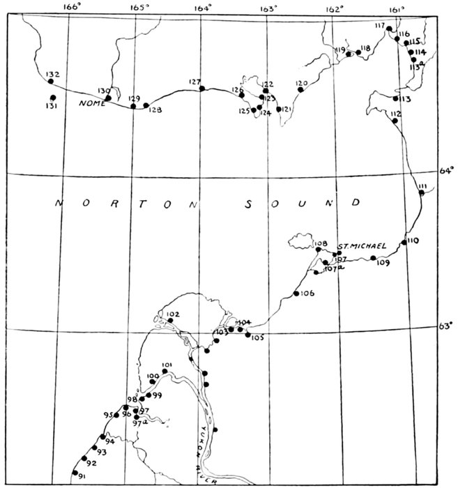
Figure 22.—Eskimo Villages and sites, Scammon Bay to Norton Sound and Bay to Cape Rodney
94. Kipniak.—Eskimo village and Coast Survey tidal station at mouth of Black River in the Yukon Delta. Nelson, 1879, reports its name to be Kipniaguk and Dall writes it phonetically Kip-nai-ak. (G. D. A.)
95. Kogomiut.—A small village.
96. Waklarok.—A small village.
97. Nunamekrok.—A small village.
97a. Eleutak.—A small settlement.
98. Nilak.—A small village.
99. Kwikluak.—A small village near the mouth of the Kwikluak Pass of the Yukon, south bank.
100. Alakanuk.—A small settlement.
101. Kwiguk.—A village on Kwikluak Pass of the Yukon, north bank.
102. Kwikpak.—Village near mouth north bank of pass of same name, Yukon River.
103. Nakhliwak.—A small village, occupied part of time, about 2 miles from mouth of Apoon Pass, Yukon; visited by the writer; small skeletal collection.
104. Kotlik Point.—A store and Eskimo camp (summer) at mouth of Apoon Pass, north bank. (A. H.)
105. Pastolik.—Four Eskimo houses, occupied winter. Extensive burial ground near. Collections, A. Hrdlička. Good prospects for excavation in burial places.
106. Pikmiktalik.—Eskimo village, near the mouth of Pikmiktalik River, about 30 miles to the south of St. Michael, western Alaska. (G. D. A.)
106a. Pastoliak.—A site near mouth of next small stream to the north. A few houses. Some burials.
107. St. Michael and Whale Island.—Old sites, northeast end of St. Michael and on Whale Island, opposite. A small living village near the point of the main island, mostly mix bloods. (A. H.)
107a. Dead village. Nelson reports it had been peopled by the Pastolik Eskimo ("Eskimo about Bering Strait," p. 263).
108. Stebbins.—A living Eskimo village at Cape Stephens.
110. Golsova.—A small camp at mouth of river of same name.
111. Unalakleet (or Unalaklik).—Important old Eskimo village, Norton Sound; western end of portage to Yukon. Population in 1880, 100; in 1890, 175.
112. Shaktolik.—Eskimo village, at mouth of Shaktolik River, Norton Sound. Population in 1880, 60; in 1890, 38. (G. D. A.) Old settlement; several old sites in this region.
113. Nuklit.—Eskimo village, on the eastern shore of Norton Sound, immediately behind Cape Denbigh. (G. D. A.) Originally given on Zagoskin's general map. (A. H.)
113a. Tapkhalik.—Old village on east shore of Norton Bay.
114. Unakhtuglig or Unagtulig.—Originally given on Zagoskin's general map. (A. H.)
115. Kviguk.—Eskimo village, on north shore of Norton Bay, at mouth of the Kviguk River. Eskimo name, from the Russians. Tikhmenief, 1861, has Kviegmiut and Kvieguk-miut; i. e., Kviguk people. (G. D. A.) Originally on Zagoskin's general map.
116. Kvig-miut.—Old village, above the preceding; originally on Zagoskin's general map.
117. Kvinkhak (now Inglestat).—Old village at head of Norton Bay. Originally on Zagoskin's general map.
118. Tulukhtulig (at or near Elim).—Old village on west coast of Norton Bay.
119. Atnik.—Old village below the preceding.
120. Camp (Reindeer).
121. Chinig.—Old village at or near the site of present mission; name now erroneously applied to village at Point Golovnin.
122. Ikalikhvig.—Present Cheenik, at Point Golovnin.
123. Old site; located 1926 (A. H.); a moderate-sized village; not promising for excavation.
124. Knikhtak.—Originally on Zagoskin's general map; now a camp, no old remains in evidence; a house and four burials on same shore, 2 miles farther south; collection (A. H.).
125. Chiukak.—Dead village; on Zagoskin's general map; some skeletal material remaining; name now applied to a village farther up the coast.
126. Chaimiut.—Dead village; originally on Zagoskin's general map; name belonged to village nearer the point.
127. Ukvikhtulig.—Dead village at Topkok Head; originally on Zagoskin's general map.
128. Dead village, 18 miles east of Nome, near Port Safety. (A. H.)
129. Azachagiag.—Dead village, west of Cape Nome; originally on Zagoskin's general map.
130. Nome.—Probably small native village at this site in the past. Now principal white settlement in western Alaska. King Island, Diomede, and some Wales natives reside on the outskirts during summer.
131. Aziak Island (Sledge Island).—Two dead villages; the principal one at the northern point of the island. Visited by Collins, 1928. Collections.
132. Sinuk.—Small old site.
133. King Island (Ukiook).—Old village, still occupied in winter; in summer inhabitants live at Nome.
133a. A village site at Cape Woolley; said to be the stopping place of the King Islanders.
134. Dead sites.
135. Burials.
136. Siniak.—Now a Lutheran Mission for the Eskimo.
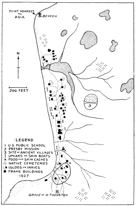
·LEGEND·
1 U·S· PUBLIC SCHOOL·
2 PRESBY MISSION·
3 SITE of ANCIENT VILLAGES·
I UMIAKS or SKIN BOATS·
X FOOD and SKIN CACHES·
✛ NATIVE CEMETERIES·
O IGLOOS or INNIES·
⬛ FRAME BUILDINGS·
·1927·
Figure 23.—Eskimo villages and sites, Wales. (By Clark M. Garber, 1927)
137. Teller.—Old Eskimo site; some still live here with, a few whites. A few Eskimo camps along Tuksuk Channel.
138. Salt Lake (Imuruk Basin).—Ruins seen on north shore. (A. H.)
139. Old sites near eastern end of lake; a Chukchee-Eskimo battlefield in vicinity. (A. H.)
140. Old village site on the St. Marys River.
141. Burials reported.
142. Wales.—Old Nykhta, Zagoskin's maps; see special description; collections.
The Northern Shore of the Seward Peninsula
This shore is but little known to science. It is dangerous of approach to any except small boats. The only place that could be visited by me was Shishmaref, a good-sized thriving Eskimo village, on both sides of which along the sea are remains of old sites with burials. The more important old settlement was that to the east of the village. Here are found large and extensive heaps, the tops of which have recently been leveled for fox cages, the whole site belonging, regrettably, to a newly established fox farm. It is an old site, though probably occupied up to white man's times, and is doubtless of some importance. Excavations would still be possible, as the bulk of the remains is intact; and though the surface skeletal material has been removed (part saved for our collections), there are indications of surface burials (assimilations by the tundra) in the ground.
Between Wales and Shishmaref are several dead sites, as shown on the map, and some of them, judging from the information obtained, are of promise. One of these settlements, "Tapkhaig," was evidently still a living village at the time of Zagoskin (1840).
Northeast and east of Shishmaref the coast is known even less than that to the west. A few miles off Shishmaref I saw from a distance—the boat could not approach nearer—what to all appearances was a large ridge of ruins, and from various maps and other sources information was obtained of several other sites, all of which represent former villages. From one of these sites on the Bucknell River Mr. Carl Lomen secured a fine piece of fossil ivory carving, and the site is said to be of much promise. The whole coast is a virgin field for archeology.
143. Mitletukeruk.—Old village site. Visited by Collins, 1928; collections.
144. Tapkhaig or Ekpik.—Old village site, originally shown in Zagoskin's general map.
145. Sinrazat.—Old site.
146. Karatuk or Shishmaref.—Living village, with ruins on both sides. Visited by A. H.; collections.
147. Kividlow.—Old site.
148. Old site reported.
148a. Siuk.—Old site.
149. Old site (?).
150. Paapkuk.—Old site.
151. Deering.—Recent settlement, but old sites probable in vicinity.
151a. Kualing.—Old village, now long dead, shown by Zagoskin. (General map.)
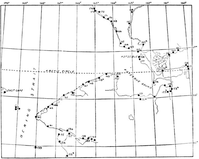
Figure 24.—Eskimo villages and sites, Seward Peninsula, Kotzebue Sound, and Arctic Coast, to Kevalina
152. Kiwalik.—A village at mouth of river of same name.
153. Dead villages reported on the two promontories; promising archeologically. On Elephant Point Nelson saw the site of an old village "with about 15 pits marking the locations of the houses." (Eskimo of Bering Strait, 264.)
153a. Buckland River. Camp sites.
153b. Old village site.
154. Old whaling place, occupied summers only. (S. Chance.)
155. Selawik.—Old village. Old igloos and camps at various places in the Selawik Basin. (S. Chance.)
156. Camps. (S. Chance.)
156a. Chilivik.—A village, now long dead, shown on the general map of Zagoskin.
157. Fish camps. (A. H.)
Kotzebue Sound, Its Rivers and Its Coast Northward to Kevalina
Figure 24 shows the village sites that it was possible to locate in these regions. Nearly all these are now "dead villages," though some Eskimo may still occasionally camp in their vicinity. A large present settlement of the Eskimo, well advanced toward civilization, is found at Kotzebue, and fish camps extend from here along the shore in the direction of Cape Blossom. Another important recent living village and school center is Noorvik on the lower Kobuk River.
Inquiries as to old sites in this region were greatly assisted by Mr. Sylvester Chance, at the time of my visit the supervisor of the Government schools of the district. At my request and with the aid of the natives Mr. Chance has compiled a list of such sites and settlements as could still be remembered, and the information has been incorporated into these records.
Among the more important ruins of this vicinity are apparently those at and near Cape Krusenstern, and again those near Kevalina farther to the northward. Archeological specimens of considerable interest were seen and partly secured from both localities. The old Kevalina especially should receive early attention, for it is being excavated by the Eskimo of the present village, though fortunately this is at some distance.
Seward Peninsula, Kotzebue Sound, and Northward
158. Kotzebue.—Old name: Kikikhtagiuk. (Zagoskin, general map.) A small white with a large Eskimo settlement. Old burials in ground (assimilated). A. H. collections.
159. Noorvik.—White and native village; school center.
160. Oksik.—Old camp, still occupied. (S. Chance.)
161. Kiana.—Old village, still occupied. (S. Chance.)
162. Shesoalik.—Old camp, still occupied in summer. (S. Chance.)
162a. Kubok.—Old village shown on general map of Zagoskin.
163. Aniyak.—Old camp, still occupied. (S. Chance.)
164. Old site reported here; said to be promising archeologically.
165. Tikizat.—Eskimo village, at Cape Krusenstern, Arctic Ocean. Eskimo name, from Petrof, 1880, who reported a population in that year of 75.
166. Kiligmak.—Old camp, still occupied.
167. Noatak.—A living village.
168. Old camp, exact location not certain. (S. Chance.)
169. Matthew or Aniyak.—Old camp.
170. Ottala.—Camp, occupied. (S. Chance.)
171. Old site reported; exact location (?).
172. Old site, rich archeologically, exact location undetermined; small collection. (A. H.)
173. Kevalina.—Living Eskimo village.
174. Pingo.—Old dead village. (S. Chance, Jim Allen.)
Kevalina—Point Barrow
POINT HOPE (TIGARA)
This is the most important ruin as well as living Eskimo village in Arctic Alaska. It is unanimously declared by the Eskimo of the coast to be one of the oldest settlements and has always been the largest native center on the coast. The point was called Golovnin Point by the early Russians; it was called Point Hope by Beechey in 1826 in honor of Sir William Johnston Hope. At the time of its visit by the revenue cutter Corwin, 1884, there are said to have been two villages;[65] the second being possibly at the site of the old whaling station. Rasmussen, who visited the village about 1924, speaks of it in part as follows:[66] "Point Hope or Tikeraq, 'the pointing finger,' is one of the most interesting Eskimo settlements on the whole coast of Alaska, and has doubtless the largest collection of ruins. The old village, now deserted, consists of 122 very large houses, but as the sea is constantly washing away parts of the land and carrying off more houses, it is impossible to say what may have been the original number. Probably the village here and its immediate neighborhood had at one time something like 2,000 souls, or as many as are now to be found throughout the whole of the Northwest Passage between the Magnetic Pole and Herschel Island."
The ruins are to the northwest and west of the present village. Those to the northwest consist of imposing heaps, which together form an elevated ridge facing the sea. It is said that this old settlement was abandoned because of the encroachments upon it by the sea, particularly during storms.
The ruins of this main compound have been for several years assiduously excavated inch by inch by the local Eskimo, and thousands of articles of great variety, of stone, bone, ivory, and wood, with here and there in the uppermost layers an object of metal, are being gathered and sold to all comers. With these are found a few human skulls and bones, but especially the skulls and bones of various animals, all of which unfortunately have hitherto been left behind in the mud. But the probably most valuable central and lower portions of the piles remain. The locality calls loudly for proper exploration, which will well repay any museum by the quantity and value of the specimens that are sure to be recovered.
FOOTNOTES:
POINT HOPE TO POINT BARROW
Information about this part of the northwesternmost coast of Alaska was obtained principally from Jim Allen, the trader at Wainwright, and Charles Brower, the trader at Barrow; but parts of the coast were also examined in person. The number of old sites is rather large, but it appears that there is not much of special promise until we reach near Barrow.
Old "igloos" southwest of Barrow: From 5 to 8 miles southwest of Barrow and at some distance (up to about 400 yards) from the shore there existed, and in part still exist, a series of elevations which the natives of Barrow always regarded as natural. On excavation the larger of these elevations proved to be old structures with numerous burials and cultural objects, and the remains, as shown elsewhere, are exceptional for this coast. Six of these "mounds" have been excavated by the University of Pennsylvania Expedition (Van Valin), while several are still remaining. It is very important that these should be carefully excavated before they are attacked by the natives of Barrow for mercenary purposes.
BARROW AND POINT BARROW
Two large living villages, with old sites and inhumed (natural) burials in their vicinity, and with some old remains between them. Barrow is the most important present mixed settlement and center of civilization in the Arctic. Besides the school, it contains a mission hospital and recently a meteorological observatory and wireless station. The tundras to the east of the village for about 1½ miles show patches of burials, particularly in the more distant parts of this region on the elevations to both sides of a small stream.
Much archeological work remains to be done about Barrow, particularly in the remainder of the old "igloos." East of Point Barrow the population is very sparse and no ruins of any note or settlements are reported before those of the Barter Island and the mouth of the Colville River.
175. Pingishuguruk.—A small old site.
176. Ketchemeluk.—A small old site.
176a. Ipnot.—Eskimo village on the Arctic coast, near Cape Thomson, a little south of Point Hope. Name from Petrof, who wrote it Ip-Not and Ipnot, and reported a population of 40 in 1880.
177. Old whaling station.
178. Point Hope or Tigara.—Eskimo village at Point Hope, Arctic Ocean. It is Tiekagag-miut of Tikhmenief, 1861; Tikirak of Petrof, 1880, who reports a population in that year of 276. Spelled Tikera in the Eleventh Census. Herendeen gives Tik-i-rah. The Eskimo name of the settlement is said to be Tik-i-rah-mum. Visited by A. H.; important collections.
179. Wewuk (or Wevok).—Eskimo village on the Arctic coast, near Cape Lisburne. Eskimo name, published by the Hydrographic Office in 1890. (G. D. A.) (Jim Allen.)
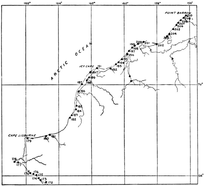
Figure 25.—Eskimo villages and sites, Kevalina to Point Barrow
180. Iniktilik.—Small village, occupied. (S. Chance.)
181. Pitmegia.—A small old site at the mouth of river of same name, north side. (Jim Allen, S. Chance.)
e. Napayochak.—Old camp, two igloos. (S. Chance.) f. Tolageak.—A small old site. (S. Chance.) g. Emelik.—A small old site. (S. Chance.) h. Pingasoogarook.—Old village, still occupied. (S. Chance.) 182. Umalik. } } 183. Koochik. } } Trapping stations; igloos. (S. Chance.) 184. } } 185. }
186. Kokolik.—Eskimo settlement, at Point Lay, Arctic coast. (G. D. A.) Old but still partly occupied village. (S. Chance.) Kelik. (Jim Allen.)
187. Napayochik.—Old camp, two igloos. (S. Chance.)
188. Tolageak.—Old dead igloos. (S. Chance.)
189. Utukok.—Old small settlement at northern mouth of Utukok River.
190. Emelik.—Old deserted igloo. (S. Chance.)
191. Kayakshulik.—A live village at Icy Cape. (Jim Allen, S. Chance.)
192. Nokotlik (?).—Old igloo. (S. Chance.)
193. Mitliktavik.—A dead moderate-sized village, about 5 miles below Kilik. (Jim Allen.)
194. Kilimantavic.—Eskimo village, near Wainwright Inlet, Arctic coast. Tikhmenief, 1861, calls it Kilametagag-miut; Petrof, 1880, calls it Kolumakturook; Hydrographic Chart 68 calls it Kelamantowruk, while later charts omit it or call it Kilimantavic. According to Murdoch this name is Ke-lev-a-tow-tin (sling). (G. D. A.) A large dead village about 20 miles below Wainwright. (Jim Allen.) Kilamitavic. (S. Chance.)
195. Old abandoned camp. (S. Chance.)
196. Wainwright.—A large living native village; some remains of old habitations on its eastern outskirts. (A. H.) About a mile south of present settlements are the remains of the old village once occupied by the Wainwright people. (Jim Allen.)
197. Kululin.—Old site.
198. Sedaru.—Old dead village.
199. Atnik.—Old dead village. (S. Chance.) Possibly same with next.
200. Itanik.—On maps Atanik. Old village, still partly occupied. (S. Chance, Jim Allen.) Called Ataniek in Tikhmenief, 1861. (G. D. A.)
201. Pinoshuragin.—Petrof, 1880, shows a native village of this name (population 29) on the Seahorse Islands. On British Admiralty Chart 593 (ed. of 1882) it is called Pingoshugarun. (G. D. A.) Pingasoogarook: Old village, still occupied. (S. Chance.)
202. Kokolak.—Two old igloos, still occupied. (S. Chance.)
203. Sakamna.—Small camp.
204. Sinaru.—Small camp about 22 miles from Barrow; visited by A. H.; small skeletal collection.
205. Walakpa.—A small dead old settlement about 12 miles from Barrow.
206. Nunava.—Small camp.
207. "Old Igloos."—A very important site archeologically. Explored partly by Van Valin. (See special section devoted to this site.)
208. Barrow.—Known also as Utkiavik, Uglaamie, or the Cape Smyth village. Important white and Eskimo settlement. Old remains. Extensive burial grounds east of village. (A. H. collections.)
209. Nunawa.—Remains of old camping site, about 4 miles from Barrow.
210. Point Barrow.—The Eskimo Nuwuk. Good-sized living village. Remains of older habitations. Population in 1853, 309. (G.D.A.)
The St. Lawrence and Diomede Islands
ST. LAWRENCE ISLAND
Ranking in archeological and anthropological importance with Wales and in some respects perhaps even exceeding the latter, is the large island of St. Lawrence, with the almost forgotten little Punuk group at its eastern extremity.
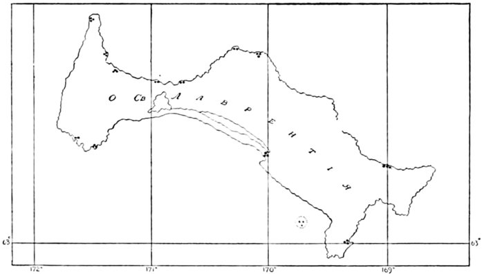
Figure 26.—Russian map of St. Lawrence Island, 1849. (Tebenkof)
The main island was discovered by Bering on St. Lawrence Day, August 10, 1728, and it was found peopled by the Eskimo. In 1849 an excellent map of it was published by Tebenkof in Novo-Archangelsk, and on this map (fig. 26) are indicated about a dozen smaller or larger Eskimo settlements, some of which, however, are not named and may already have been "dead."
About 1878 there were still six settlements with somewhat less than 1,500 Eskimo inhabitants on the island. That winter (1878-79) not less than 1,000 of the population died of famine (Hooper), three of the villages becoming completely depopulated and a fourth nearly so. The Punuk Island village may have become extinct about the same time.
To-day there are on the St. Lawrence Island but two living settlements, the main one, now known as Gambell, at the old site of Chibukak on the northwestern cape, and the other, Savonga, about 40 miles east of it, near Cape North.
A number of the old sites on this island, and also that on one of the Punuks, indicate a long occupation, antedating by far the advent of the Russians. The accumulations rise in some places to imposing heaps or ridges. Their frozen contents yield quantities of fossil ivory, all of which shows the work of man, and among them occur specimens with fine curvilinear designs and of high scientific as well as artistic value.
Through Nelson in 1881 and R. D. Moore in 1912 the Smithsonian Institution has acquired a large quantity of human skeletal material from the main island, and there is now (1928) an expedition of the Institution under Collins on the Punuk as well as the St. Lawrence exploring some of the principal ruins.
THE DIOMEDE ISLANDS AND THE ASIATIC COAST [Figs. 27 and 28]
The smaller or American Diomede, though a very inhospitable place, supports, and that evidently since long, a small Eskimo village of stone houses, below and about which there is a considerable accumulation of refuse. Doctor Jenness dug here for a short time in 1926.
The larger or Russian Diomede has two villages, each of which is larger than the one on the smaller island. There are also said to be some remains in a broad depression on the eastern side of the island, while skeletal remains are reported by the natives to exist among the rocks on the top. This island is in need of thorough attention. Its people are reputed to be skilled ivory workers. They come yearly to Nome, where they were visited and seen at their work by the writer. They bring each year some fossil ivory, said to come mainly from the Asiatic coast, and among this are occasionally articles of much interest.
Ruins of Eskimo villages are also present along the coasts of the Chukchee Peninsula, both those facing the Bering Sea and those along the Arctic. Very little is definitely known or can be found from the American Eskimo about these ruins, and some of them may not be Eskimo. Nelson in his book (p. 265) reports briefly on a few about Cape Wankarem. Interesting objects of the fossil ivory culture are said to occur in these old sites as far west as the Kolyma, but nothing is certain except that there are ruins, that a good number of them are probably Eskimo, and that fossil ivory, both worked (walrus) and unworked (mammoth), comes from these coasts. A noteworthy report is that of a large native cemetery on the Bering Sea side, with hundreds of burials in rough stone-slab graves. Information of this was given me by Joe Bernard, well known in connection with Bering Sea explorations, who had seen the site in person.
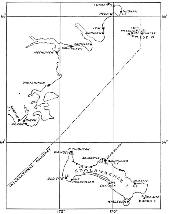
Figure 27.—Eskimo villages and sites, St. Lawrence Island, the Diomedes, and the eastern Asiatic coast
211. Gambell (or Chibukuk).—Old Eskimo settlement on the northwest cape of St. Lawrence Island. United States National Museum expedition, 1912, by Riley D. Moore; anthropometric data; important collections.
212. Small sites, north bay, St. Lawrence Island, indicated on 1849 Russian map (q. v.).
213. Savonga.—A small modern Eskimo village. A. H., 1926; some collections.
214. Ruins of an old site 4 miles northeast of Savonga. Important archeologically.
215. Kukuliak.—Dead village.
216. Former summer site. Given on the 1849 Russian map.
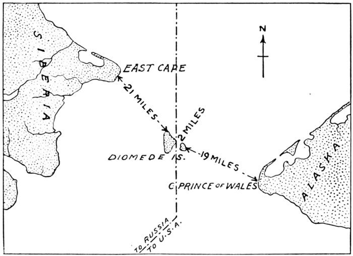
Figure 28.—The Bering Strait Islands
217. Important old site with large accumulations on one of the two Punuk Islands. Explored 1928 by Collins; collections.
218. Kialegak.—Dead village. Important archeologically. Partly explored by Collins, 1928; collections.
219. Chitnak.—One of the dead villages of 1879. (Nelson, Hooper.)
220. Puguviliak.—One of the dead villages of 1879. (Nelson, Hooper.)
221. Old site; no details available.
222. Living small village on the smaller (American) Diomede Island. Some old accumulations. A. H., 1926, collections; some excavations same year by D. Jenness.
223. Nunarbuk.—Village still occupied, on greater (Russian) Diomede, located on an elevated slope around the southern cape of the island. Skeletal and other remains reported on top of mesa.
224. Village, still occupied, on an elevated saddle near middle of west coast of island.
225. Eskimo village, East Cape of Asia. Other villages indicated along the coast of Chukchee Peninsula. Others on north coast. (See Nelson, The Eskimo of Bering Strait, p. 265.)