JOURNEY ALONG THE BANKS OF THE NILE.
Reading edition
FROM ASSOUAN TO MAHASS, ON THE FRONTIERS OF DONGOLA.
After having visited most of the celebrated ruins in the valley of the Nile, I arrived at Assouan on the 22d of February, 1813, being actuated by a strong desire of continuing my journey up the river, as far as I should be able to do it, without exposing myself to imminent danger. During a week’s stay at Esne, the last town of note in Upper Egypt, I had collected a good deal of information concerning the state of Nubia, and had taken my measures accordingly. Amongst other arrangements, it became necessary for me to purchase a pair of good dromedaries, one for myself, and another for the guides, whom I might hire at the several places I should pass through in Nubia;[1] I therefore sold the two asses, which had carried me from Cairo to Esne, and bought, for about 22l., two dromedaries which proved upon trial, to be excellent animals; for during a journey of thirty-five days, from Assouan to Mahass, and back again, I allowed them only one day’s rest, and generally rode them ten hours per day. There is a market for camels in Esne, famous all over Egypt, from being frequented by the Arabs Bisharye and Ababde, who possess the best breed of camels in these parts of Africa. The Turkish governor of Esne, Hassan Beg, a native of Cyprus, furnished me, at my request, with a strong letter of recommendation to the three brothers, sons of Soleyman Kashef, who at present govern Nubia: and it was hoped that the increasing power of Mohammed Aly, the Pasha of Egypt, would render such a letter from one of his principal officers, of some weight. I had, besides, a firman from the Pasha himself, but as it was written in Turkish, which nobody reads in Nubia, and of a general nature, I placed little reliance upon it, further than as it contained among other names, those of the castle of Ibrim, and of its governor, which might be distinguished even by an Arab reader. The letter upon which I principally founded my hopes of success, was from the house of Habater, the principal merchants in Esne, to whom I had been recommended by a friend at Cairo. The Habater have almost monopolized the Nubian trade in dates; they act as the chargés d’affaires of the Nubian princes in all their political transactions with Egypt, and being also Sherifs, or descendants of the Prophet, and men of large fortunes, they enjoy great credit, and their recommendation may be useful to travellers and merchants in the whole route up the Nile, as far as Sennaar.
After an easy journey of four days from Esne, I reached Assouan, the most romantic spot in Egypt, but little deserving the lofty praises which some travellers have bestowed on it for its antiquities, and those of the neighbouring island of Elephantine. Hassan Beg, of Esne, had given me a letter to the Aga of Assouan, to whom I applied for a guide to conduct me as far as Derr, where Hassan Kashef, one of the Nubian chiefs, resides: an old Arab, a native of Nubia, was soon found for this purpose, and after bargaining a long while, I at last agreed to give him one Spanish dollar for his services to Derr, which was considered an ample payment for a journey of 140 miles. I left at Assouan my servant, with the little baggage I had; and after purchasing some provisions, started, with my guide, on the 24th of February, carrying nothing with me but my gun, sabre, and pistol, a provision bag, and a woollen mantle (Heram) of Moggrebyn manufacture, which served either for a carpet, or a covering during the night. I was dressed in the Thabaut, or blue gown, of the merchants of Upper Egypt, having quitted my common Turkish travelling dress at Esne. After estimating the expenses which I was likely to incur in Nubia, I put eight Spanish dollars into my purse, in conformity with the principle I have constantly acted upon during my travels, namely, that the less the traveller spends while on his march, and the less money he carries with him, the less likely are his travelling projects to miscarry. After a journey of 450 miles up the Nile, from Assouan, and the same distance down again, I returned with three dollars, having spent about five dollars, including every expense, except the present to Hassan Kashef.[2] This must not be attributed to parsimony; I mention it here as a part of my plan of travelling, and by way of advice to all travellers who visit unknown and dangerous countries in the East.
February 24th, 1813. I left Assouan at noon, and proceeded by the tombs of the ancient Saracen town of Assouan, on the east side of the hill where the French under Desaix raised a bastion. A high brick tower, dedicated to the memory of the Turkish saint, Shikh Wanes (شيخ وانس), stands near it. The Turkish sepulchres cover a space of nearly three miles in circumference. Here a great number of highly esteemed saints are buried, whose tombs are visited by devotees from all parts of Egypt. The Cufic tombstones are innumerable, but the inscriptions upon them are not of a remote date: and the letters are badly shaped. Makrizi, the Egyptian historian, relates, that in the year 806 of the Mohammedan æra, 21,000 persons died of the plague at Assouan; a fact by which we may estimate the importance of the town in those times. About one mile distant from the tombs begins the brick wall mentioned by Denon, called Hayt el Adjour (حيط العجور), which continues along the sandy plain between the granite rocks, as far as the neighbourhood of the island of Philæ. The inhabitants say that this wall was built by a king of the name of Adjour. I think it was intended as a defence against the inroads of the Bedouins of the eastern mountain, at the time when a brisk overland transport trade existed between Philæ and Syene. The natives say that it was originally the embankment of a canal; and Norden is of opinion that in ancient times, the bed of the Nile was on this side. But this seems impossible, as the ground evidently rises from Philæ towards Assouan. On the granite rocks along the road, hieroglyphic inscriptions are met with, which increase in numbers as we approach the island. There are also some illegible Greek inscriptions, which probably once recorded the names of curious Greek travellers. There is another and longer road from Assouan to Philæ, along the side of the river, by the Cataract.
After riding about four miles from Assouan, we reached an open plain, free from rocks, on the west side of which the river flows: here the ruins of the island of Philæ (انَس الوجود), Anas el Wodjoud[3]) presented themselves to my view. As there was no vessel at hand to convey me over to the island, and knowing that I should pass this way on my return to Assouan, I did not stop any longer than was necessary to look at the granite rocks, on the banks of the river, where the famous seat, of which many travellers have given drawings, principally attracts notice. The small village opposite Philæ is called Birbe, and is the boundary of Egypt. The different hamlets, from hence down the river, as far as Assouan, form part of the territory of Birbe; which, in consequence of old firmans from the Porte, enjoys an entire exemption from all kinds of land tax. On the south side of Birbe commences the territory of the Nubian princes, to which Philæ belongs. The natives, in the invirons of the Cataract, are an independent race, and boast of the security which the nature of the ground affords to their homes; many of them inhabit the islands, and support their families principally by fishing in the river.
At the time of my visit, the Nubians belonging to Assouan were at war with their southern neighbours, occasioned by the latter having intercepted a vessel laden with dates, knowing it to belong to a merchant of Assouan. A battle had been fought opposite Philæ, a few days before my arrival, in which a pregnant woman was killed by a stone; for whenever the Nubians are engaged in skirmishes, their women join the party, and furiously attack each other, armed with slings. The southern party, to whom the deceased belonged, was now demanding from their enemies the debt of blood, not only of the woman, but of the child also, which she bore in her womb at the time of her death. This the latter refused to pay, and being the weaker in numbers, and there being no garrison at Assouan to support them, the men thought proper to retire from the field; they abandoned the villages nearest to Philæ, leaving only their women and female children, and retired with the males to Assouan. On my return from Mahass, peace had not yet been restored; the Nubians were still at Assouan, where a caravan of women arrived daily, with provisions for their husbands.
We recrossed the before mentioned plain, opposite the island, where I observed numerous fragments of pottery, and then ascended the mountain to the south of it, there being no road fit for camels by the side of the river. We traversed the deep valleys of this mountain for about two hours. The rocks present an endless variety of granite, among which a rose-coloured species is particularly beautiful. Sienite, and red feldspath, together with granite, compose this chain. We afterwards descended again to the side of the river, near one of the small hamlets which compose the district of Shamet el Wah (شعامة الواح). The bed of the river here is free from rocks and islands, but its banks, on both sides, are so narrow, that there is hardly a hundred yards of cultivable ground. Half an hour farther, we reached the village of Sak el Djemel (ساق الجمل), belonging to the district called Wady Debot, and alighted at the Shikh’s house, where we passed the night. Here I first tasted the country dish which, during a journey of five weeks, became my constant food; thin, unleavened, and slightly baked cakes of Dhourra, served up with sweet or sour milk. From the Dhourra being badly ground, this food is very coarse, and nothing but absolute hunger could have tempted me to taste it.
February 25. I continued along the east bank of the river. The road the whole of the way to Derr is perfectly safe, provided one of the natives accompanies the traveller. I every where found the people to be possessed of a degree of curiosity which I had never met with before. Whenever we passed a village, often at a full trot, the men came running out of their houses, and across the fields, to ask my guide who I was, and what was the object of my journey. The answer was, that I was sent from Esne to Derr, with letters from the governor to the Nubian chiefs. They would then enquire after the contents of the letters, and, that they might do this more at their ease, would press me to alight, and breakfast with them. One hour and a half brought us to Wady Syale (وادي سياله). Two hours and a half, Wady Abdoun (وادي عبدون). Four hours, Wady Dehmyt, (وادي دهميت). All the villages, as far as Dóngola, are called Wady, or valley. There are always three or four of them comprised under one general name: thus, Wady Dehmyt extends about four miles along the bank of the river, and includes upwards of half a dozen hamlets, each of which has its particular name. Travellers, therefore, who note down the names of villages in these parts, will easily be led into mistakes, by confounding the collective appellation with that of the single hamlet. There are few large villages; but groups of five or six houses are met with wherever a few palm trees grow on the banks of the stream, or wherever the breadth of the soil is sufficient to admit of cultivation.
I found Daoud Kashef, the son of Hosseyn Kashef, encamped with a party of men at Dehmyt, in huts constructed of Dhourra[4] stalks. I alighted at his own hut, and breakfasted there, informing him, that I was sent on business to his father and uncles. The governors of Nubia are continually moving from one part of their dominions to another, to collect the tribute from their subjects, and are always accompanied by a guard of forty or fifty men, in order to levy it by force, wherever necessary, and to be the better able to commit depredations. On the night preceding my arrival at Dehmyt, a Nubian came to me at Sak el Djemel, to complain of Daoud’s tyranny; it had been reported to the latter, that this man, with his family, was secretly indulging in bread made from wheat, a sufficient proof of great wealth. Daoud’s people, in consequence, surrounded his house during the night, and demanded from him a camel, as a present to their master: on his refusal to comply, they attacked the house; and as the owner had no near neighbours, he in vain attempted to defend himself: he was severely wounded, and the whole of his property fell a prey to the aggressors. Daoud was but poorly equipped; he was dressed in the common white shirt of the country. He asked me for some gunpowder,[5] and, on my telling him that the supply I had of that article was scarcely sufficient for myself, he did not appear at all offended by the refusal. Several hundred peasants were assembled round the camp, with herds of cows and sheep, with which they pay their land tax.
We quitted Dehmyt, and in five hours from our departure from Wady Debot, reached Wady Kardassy (وادي كرداسه), where I passed the ruin of a small temple, of which one corner of the wall only remains standing. I saw no fragments of columns; but, on some of the stones which lay scattered about, hieroglyphic figures are sculptured; and the winged globe appears upon several of them. On the west side of the river, opposite to this place, is a large ruin. My guide told me, that, at a long day’s journey from hence, in the eastern mountain, are the ruins of a city called Kamle. In five hours and a half, we came to Djama (جمع); and in six hours, to Tafa (تافه); the villages so named lying on both sides of the river. The plain between the banks of the river and the foot of the mountain is about a quarter of a mile in breadth. Here are the ruins of two buildings, standing near each other, of which nothing now remains but the foundations; they are constructed of sand-stone, in a very rude manner, and are about forty feet square. There are no fragments of columns, nor of sculptured stones of any kind. There are also some ruins on the opposite side. These are undoubtedly the remains of Taphis and Contra Taphis.[6] Immediately to the south of the ruins, the mountains on both sides of the river prevent all passage along its banks; the road, in consequence, lies, for one hour, across the mountain, which I again found to be composed of rocks of granite. The granite chain had been uninterrupted from Assouan to Dehmyt. To the south of Dehmyt, the mountain which borders the river is composed of sand-stone, and continues thus as far as the second Cataract, at Wady Halfa, with the exception only of the granite rocks above Tafa, which extend as far as Kalabshe.
We descended again to the bank of the river in one hour, and passed the village of Darmout (درموت), built partly upon a rocky island, and partly upon the high rocks of the eastern shore. The effect of the evening sun upon the black granite islands, surrounded by the pure[7] stream, and the verdant banks, was very beautiful. From hence to Tafa the river is studded with numerous islands. Seven hours and three quarters brought us to El Kalabshe (القلابشه), the largest Wady, or assemblage of villages, we had yet passed. Although the plain is very narrow, there are nevertheless considerable mounds of rubbish and broken pottery, along the foot of the mountain, indicating the site of an ancient town; and as there is a large ruin opposite to this place, on the western bank,[8] we may safely conjecture these to be Talmis and Contra Talmis. There are no remains of any edifice on the eastern side. The two hundred houses which compose the village on that bank occupy a space of about half an hour in length. In eight hours and a half we came to El Shekeyk (الشقيق); in eight hours and three quarters, to Abou Hor (ابو هور). In the course of this day, I passed several beds of torrents. When the rains are copious in the mountain, torrents occasionally rush down into the river, but they never continue longer than two days. These torrents account for the momentary increase of the Nile in Egypt, during the winter, when the river is at its lowest. Throughout Nubia, rain never falls in the valley, some light showers excepted; but there is a regular rainy season in the eastern mountains, as far as Suez, which produces abundant crops of wild herbs, and pasturage for the cattle of the Bedouins who inhabit those districts. I had occasion to mention a similar phenomenon, in my former Journals, in the mountains of Eastern Palestine. In the Ghor, or valley of the Jordan, rain seldom falls, while the mountains on either side have their regular rainy season. Our host at Abou Hor served us this evening with the dish called Asyde, which consists of the green ears of barley boiled in water, and mixed with milk.
Feb. 26th. The Wady Abou Hor is about three quarters of an hour in length. After a ride of two hours we passed the village Dandour (دندور); three hours and a half, Wady Abyadh (وادي ابيض) the plain still continuing very narrow. In order to gain some soil from the river, the ancient inhabitants of Nubia had erected numerous piers or jetties of stone, extending for twenty or thirty yards into the river; which, by breaking the force of the stream, would leave, on their northern side, a small extent of land free from water. Many of the piers still remain, but in a decayed state. I generally observed, on the western side of the river, a similar structure, exactly opposite to that on the eastern. In four hours and a half, Merye (مريه); five hours, Gyrshe (كرشه). I passed the ruins of an ancient town, probably Saracen, built partly of bricks, and partly of small stones. The natives say that a king of the name of Dabagora reigned here. The plain at Gyrshe is broader than I had any where yet seen it, to the south of Assouan, being about a mile. Like all the villages I had hitherto passed, Gyrshe is but poorly inhabited, two-thirds of the houses being abandoned. The country had been ruined by the Mamelouks, who remained here several months, when on their retreat before the Turkish troops of Mohammed Aly; and the little they left behind was consumed by the Turks under Ibrahim Beg, Mohammed Aly’s son, who finally succeeded in driving the Mamelouks out of Nubia, and across the mountains, into the plains of Dongola. A terrible famine broke out after their retreat, in which one-third of the population of Nubia perished through absolute want; the remainder retired into Egypt, and settled in the villages between Assouan and Esne, where numbers of them were carried off by the small-pox. The present inhabitants had returned only a few months before my visit to these parts, and had begun to sow the fields after the inundation had subsided; but many of their brethren still continued in Egypt. The great number of newly-dug graves which I observed near each village, were too convincing proofs of the truth of the melancholy accounts which the natives gave me.
In six hours I came to Wady Kostamne (قُستَمنه), a well built village. Here the Mamelouks fought a battle with the troops of Ibrahim Beg, and were routed. They retreated to the eastern mountains, where they remained for several months, till their enemies retired to Assouan; when the greater part of the Begs descended to the banks of the Nile, and as the stream happened at that moment (May, 1812) to be extremely low, they crossed it at a ford near Kostamne,[9] with all their women and baggage. Some of them continued their route southward along the western bank, plundering in their way all the villages of Derr, Wady Halfa, Sukkot, and Mahass; while the chief Begs, with their Mamelouks, made a short cut through the western desert; and the whole party united again on the banks of the Nile, near Argo, one of the principal places within the dominions of the King of Dongola;[10] mustering in the whole about three hundred white Mamelouks, and as many armed slaves, the wretched remains of upwards of four thousand, against whom Mohammed Aly had begun his contest for the possession of Egypt. The fate of about twelve hundred of them, who, with their chief, Shahin Beg, were treacherously slaughtered in the castle of Cairo, notwithstanding the most solemn promises of personal security had been given to them, is too well known to be repeated here; but a similar massacre, which took place at Esne, is less known, and may here be related, as serving to prove the stupidity and infatuation which have always presided over the councils of the Mamelouks. These fierce horsemen had sought refuge in the mountains inhabited by the Ababde and Bisharye Arabs, where all their horses died from want of food, and where even the richest Begs had been obliged to expend their last farthing, in order to feed their troops, provisions being sold to them by the Arabs at the most exorbitant prices. Thus cut off from all the comforts, and luxuries of Egypt, to which they had been accustomed from their infancy, Ibrahim Beg thought it a propitious moment to ensnare them, as his father had done their brethren at Cairo. With this design, he sent them the most solemn promises of safe conduct, if they would descend from the mountain, and pledged himself that they should be all placed in situations under the government of Mohammed Aly, corresponding with the rank which each individual then held amongst themselves. It will hardly be believed that, well acquainted as they were with the massacre at Cairo in the preceding year, more than four hundred Mamelouks, headed by several Begs, accepted the delusive offer, and descended in small parties from the mountains. They were stripped in the way by faithless guides, so that, with the exception of about thirty, the whole reached the camp of Ibrahim Beg, then near Esne, in a state of nakedness. After the different parties had all joined, and it was ascertained that no others were ready to follow them, the signal of carnage was given, and the whole of them, with about two hundred black slaves, were unmercifully slaughtered in one night. Two French Mamelouks only were saved, through the interest of the physician of Ibrahim Beg. Similar instances of perfidy daily occur among the Turks; and it is matter of astonishment, that men should still be found stupid enough to allow themselves to be thus ensnared by them.
Eight hours and a quarter brought us to Djebel Heyaty (جبل حياتي) eight hours and a half to Kobban (قبّان), opposite the fine temple of Dakke, which stands on the western bank.
February 27. Near Kobban are the remains of an ancient town, enclosed by a wall of bricks burnt in the sun, much resembling that of Eleithias, to the north of Edfou in Egypt. The length of the oblong square is about 150 paces, its breadth 100 paces. The wall is upwards of 20 feet in thickness, and in several places more than 30 feet in height. Within its area are ruins of private habitations, partly constructed of stone, and partly of bricks. Some capitals of small columns of the Egyptian order lay about. On the S. E. corner of the wall, beyond its precincts, is the ruin of a very small Egyptian chapel, of a rude construction, with a few stones only remaining above the foundations. There are several hieroglyphic figures: a chariot sculptured on a stone indicates that a battle was represented. It appears that this enclosure, which stands close to the river, was meant as a castle. Large mounds of rubbish, the ruins of the ancient town, continue for about five minutes walk further. In one hour, I reached Oellaky (علاقي), having passed, close to it, a broad canal: similar canals are met with in almost every part of Nubia, where the extent of the shore, and its height above the level of the river, rendered artificial irrigation necessary; but they are now no longer taken care of, and are gradually choaking up. The plain here is a mile in breadth. Oellaky has given its name to a chain of mountains, which begins to the east of it, and runs quite across the high hills of the eastern desert, towards the shores of the Red Sea. If I am not mistaken, Bruce passed this chain. According to the reports of the natives, and the unanimous testimony of all the Arabian geographers, this mountain, called Djebel Oellaky, contains gold mines; I am inclined to believe, however, that the Bedouins, who alone wander about in those districts, and who must therefore be the authors of such reports, have mistaken yellow mica for gold; for the river carries down with it through the whole of Nubia a great deal of micaceous sand. Hassan Beg, the governor of Esne, who is fond of mineralogy, as far as it relates to precious stones and metals, had read in some book, of the mines of Oellaky; and being desirous to ascertain whether the report was true, sent four of his soldiers to escort a Greek, who pretends to a knowledge in stones, with an order to make researches in the mountain. They reached the village of Oellaky, and proceeded from thence about two hours to the eastward; but being frightened by a report that a large party of Mamelouks was descending from the mountain, they immediately returned, throwing the whole country into an alarm. I had met them at Dehmyt, when they earnestly pressed me to return with them, assuring me that the Mamelouks would certainly strike off my head, if they learnt that I was the bearer of letters from Hassan Beg. There was some truth in the report; for two Mamelouk Begs, Ibrahim Beg Djezayrly, and Osman Beg Bouhanes, who had remained in these mountains with the Arabs, after the departure of their companions for Dongola, in order to be as near at hand as possible, in the event of a change taking place in Egypt, had at last, with five of their women, and two servants only,[11] been obliged, through absolute want, to rejoin their brethren. All the money and valuables which they possessed had been extorted from them by the Arabs, as the price of provisions; their horses had died; their Mamelouks had deserted them; and their clothes and equipages were in rags; in this state, they abandoned for the present all ideas of the re-conquest of Egypt, and quitting their station near the shores of the Red Sea opposite Djidda, they took the road to Derr. The arrival of the Greek and the four soldiers above mentioned drove them back one day’s journey into the mountain, until their spies informed them of their departure; they then returned, and arrived at Derr one day before me.
I travelled from two to three hours along a rocky shore, opposite the island Derar (درار), which is well cultivated, and about three quarters of an hour in length. On the western bank is the village of Korty. From three to four hours the Wady Meharraka (وادي محرّقه) extends; and farther south, from four to five hours, the Wady Thyale (وادي ثياله). I had here the pleasure of falling in with two English travellers, Messrs. Legh and Smelt, and Captain Barthod, an American; I had already seen the two former at Cairo, and at Siout. They had left Cairo on board a country ship, two days after my departure from thence, and on reaching Assouan, had hired a large boat to carry them up to Derr, from whence they had visited Ibrim, being the first Europeans who had reached that place, and examined the antiquities between it and the island of Philӕ; for Norden saw them only through his telescope. I hailed their boat as I rode along the bank of the river, and we passed a few hours together, after which they pursued their course down to Assouan. In five hours and a half, I came to Wady Name (وادي نعمه); in six hours, Bareda (بارده); six and a half, Kokan (قوكان); here I saw a great number of crocodiles, the first I had seen since leaving Cairo, my road through Egypt having seldom been close along the river. Here also I observed stone piers in the river at several places. Seven hours and a half, Wady Nasrellab (وادي نصرالاب). South of Kokan, for two hours, the mountains come down so close to the river as to leave no space for a passage along its banks, and of course none for cultivation. We passed several beds of torrents. Eight hours and a half brought me to Wady Medyk (وادي مديك), where I slept.
February 28th. One hour from Wady Medyk is Wady Seboua (وادي سبوع), or the Lion’s Wady, so called from the figures of sphynxes with the bodies of lions, which stand before the ruined temple on the west side of the river, opposite to Seboua. This is the best cultivated part of the country which I met with, between Assouan and Derr. The inhabitants of Seboua, and those of Wady el Arab, to the south of them, are active merchants, and possessed of considerable wealth. They travel across the mountain to Berber (where Bruce’s Goos lies), eight days journies distant, and import from thence all the different articles of the Sennaar trade. This route is so perfectly secure that parties with four or five laden camels arrive almost weekly; but the character of these Arab merchants themselves is very indifferent; they are treacherous, and despised for their want of hospitality. The inhabitants of Seboua and Wady el Arab are not, like all their neighbours, of the tribe of Kenous,[12] but belong to the Arabs Aleykat (عليقات), who are originally from the Hedjaz.[13] Some of them wander about in the eastern mountains, like Bedouins; they all speak exclusively Arabic, and the greater part of them are ignorant of the language of the Kenous. The governors of Nubia levy a tribute from all the goods imported from the south by the Aleykat; but the latter being numerous, and well armed, seldom submit to any extra exactions from the governors, and have thus acquired considerable property. They dispose of the slaves, ivory, gum arabic, ostrich feathers, and camels, which they bring from Berber, in Upper Egypt, where they purchase the merchandize necessary for the southern market.[14]
Two hours and a half from Wady Medyk is Wady el Arab (وادي العرب), where, besides the Aleykat, Arabs of the tribe of Gharbye (غربي) have been settled since the period of the Mohammedan conquest of Nubia. The shore is every where well cultivated. From three hours and a half, till five hours and a half, the rock is close to the river, with a narrow footpath on the bank; the road for camels traverses the rugged sand-rocks and deep valleys of the mountain. Five hours and a half brought us to Wady Songary (وادي سنكاري); six hours and a half, to Korosko (قرسكو). Here the shore widens, and a grove of date-trees begins, which lines the banks of the river as far as Ibrim. Groups of houses are now met with at every hundred yards, which render it difficult to determine the exact limits of each village. At seven hours, is Beshyra Nerke (بشير نرقه); seven and a quarter, Shakke (شقّه); eight hours, Kherab (خراب). Here are some heaps of hewn stones, the remains of ancient edifices, from which the village has taken its name (Kherab signifying ruined). Nine hours, Wady Oeshra(وادي عشرا). Nine and a half, Wady Diwan (ديوان). Ten and a half, Derr, (الدر), the chief place between Egypt and Dongola. I do not remember to have seen, in any part of Egypt, fields more carefully cultivated than are those between Korosko and Derr. The peasants’ houses too are larger, and more cleanly, than those of the Egyptian Felah.
March 1st. I had reached Derr late in the evening, and alighted at the house of Hassan Kashef, as do all travellers of respectability, and where the two Mamelouk Begs above mentioned were also quartered. As the governor had retired to his women’s apartments, I did not wait upon him, but went to rest, having refused to answer all the inquisitive questions put to me as well by his people, as by the servants of the Begs; but the next morning, Hassan, after having visited the Mamelouks, surprised me in the open hall where I was lodged, before I had risen, and immediately asked me what was the object of my arrival, and whether I was a merchant, or sent to him by the Pasha of Egypt. It had been my intention, before I knew of the arrival of the Mamelouks, to pass for a person sent by the Pasha upon a secret mission into Nubia, having learnt from the people of Upper Egypt, that the governors of that country dread the power of Mohammed Aly, and would not dare to molest me: but when I was apprised of the arrival of the two Begs, and being also led to believe, from the conversation of the peasants at whose houses I had slept in my way up to Derr, that the Nubian princes were as much afraid of the Mamelouks, their southern neighbours, as they are of their northern one, I thought it would be dangerous to disguise my real intentions; and, encouraged by the success of Messrs. Legh and Smelt, I candidly told Hassan Kashef, that I had merely come to make a tour of pleasure through Nubia, like the two gentlemen who had been at Derr before me; and presented to him, at the same time, my letters of recommendation. I however profited little by my candour. The frank avowal of my intentions was interpreted as a mere scheme of deception; no one would believe that I was only a curious traveller; the Arabic I spoke, and my acquaintance with Turkish manners, led the Kashef to believe that I was a Turk, and sent by Hassan Beg of Esne to watch his motions; and the two Begs, although they had behaved remarkably civil to me, upon my visiting them, strengthened the Kashef in his opinion. I spent the whole of this day, and part of the next, in negociations with the governor, in order to obtain a guide to conduct me to the southward. An offering of soap,[15] coffee, and two red caps, worth, altogether, about sixty piastres, which I made to him, would, at any other time, have been very acceptable; but the presents made to him by Messrs. Legh and Smelt were worth about 1000 piastres, and they had only gone to Ibrim, “while you,” said the Governor, “give me a few trifles, and wish to go beyond that place, even to the second Cataract.”—I replied, that my present was certainly not proportionate to his rank and claims; but that it was already more than my means could afford; and that I thought myself possessed of an advantage over my predecessors in my letters of recommendation from Esne. The following lucky incident at last led to the attainment of my wishes: I had been informed that a large caravan was on its way from Mahass to Esne, and that a considerable part of the merchandize belonged to the Kashef himself, who wished to sell it at Siout and Cairo. I therefore waited privately upon him, and told him, that if I returned to Esne, and the Beg who had given me the letter of recommendation, should be informed of the little attention that had been paid to his letter, in not allowing me to pass beyond the second Cataract, notwithstanding its express tenour that I should be so permitted, he would readily think himself justified in raising a contribution upon the caravan on its arrival at Esne, or impeding its route towards Siout. This became a matter of serious reflection with the Kashef; and he at last addressed me in the following terms: “Whoever you may be, whether an Englishman, like the two other persons who passed here, or an agent of the Pasha, I shall not send you back unsatisfied: you may proceed; but, farther than Sukkot the road is not safe for you; and from thence, therefore, you will return.” I requested a letter of recommendation for Sukkot, which was immediately written, and a Bedouin guide also was soon found. I bought some Dhourra and dates, for provision on the road, and left Derr a little before noon on the 2d of March, the two Mamelouk Begs in vain endeavouring to create obstacles to the prosecution of my journey. But before I continue the description of my route, I shall here give some details concerning the country I had already passed through from Assouan, and its inhabitants.
The general direction of the river from Assouan to Korosko is south; it there takes a western course, which it retains the whole of the way to Dongola. The eastern bank is, throughout, better adapted for cultivation than the western; and wherever the former is of any breadth, it is covered with the rich alluvial earth deposited by the Nile. On the western side, on the contrary, the sands of the desert are impetuously carried to the very brink of the river, by the north-west winds which prevail during the winter and spring seasons; and it is, generally, only in those places where the course of the sandy torrent is arrested by the mountain, that the narrow plain admits of cultivation. The eastern shore is, in consequence, much more populous than the western; but it is not a little singular, that all the chief remains of antiquity are upon the latter. The ancient Egyptians, perhaps, worshipped their bounteous deities more particularly in those places where they had most to dread from the inimical deity Typhon, or the personified desert, who stands continually opposed to the beneficent Osiris, or the waters of the Nile.
The bed of the river is, in general, much narrower than in any part of Egypt, and the course of its waters less impeded by sand-banks. Immediately after the inundation, the poor Nubians cultivate, on the narrow shore, Dhourra, and the grain called Dokhen (دخن), of which bread is made;[16] but it is upon the crop of Dhourra that they depend for their subsistence; while its dry stalks serve during the whole of the summer, as food for their cattle, instead of straw. The Birsim, or lucerne of Egypt, is unknown here, as well as in Upper Egypt, south of Kenne. After the inundation has subsided, and the Dhourra harvest is finished, the soil is irrigated by means of water wheels (Sakie ساقيه), turned by cows, which throw up the water either from the river, or from pits dug in the shore; for water is every where found in plenty, on digging to the depth of fifteen or twenty feet, after the inundation; it is the same in Upper Egypt during the summer; but the water of these pits or wells has a disagreeable, brackish taste; and even the best of it is very heavy, and difficult to digest.[17] In order that the soil may be well soaked, the fields are divided into numerous small squares, of about ten feet each, with elevated borders, so as to retain the water, which is conveyed to them by narrow side channels. The fields are then sown for the second time with barley, a kind of bean called Kasherangag, tobacco of the worst kind, and the French bean (Louby), the leaves of which afford, when boiled, a soup much esteemed among the Nubians. I seldom saw any wheat. Near Derr are some fields of lentils, peas, and water melons. On the declivity of the shore, towards the river, which is more humid, and less exposed to the sun than the upper plain, a kind of bitter horse-bean (Turmus ترمس) is sown, which does not require irrigation; they are well known in Egypt, and are the Lupini of the Italians. The wheat and barley are ripe in the middle of March. In the end of April, after the latter is reaped, the ground is sometimes sown, a third time, with Dhourra; and watered by means of the water-wheels. This is called “the summer seed” (زرع صيفي), and comes to maturity in the month of July; but the most fertile spots only are used for it.
Besides the palm and Doum[18] tree, a variety of thorny trees of the Mimosa species (Sant صَنت) grow wild on the banks of the river. The low shrub of the Senna (Senna mekke (سنا مكّه), is every where met with from Esne to Mahass, growing wild, but upon those spots only which have been inundated. This Senna, however, is little esteemed for its quality, and is used only by the peasants, who are well acquainted with its medicinal virtues. The Senna of Upper Egypt is distinguished from that of Nubia, and of the mountains, by the larger size of its leaves. Among the mounds of sand on the western shore grows the tamarisk (Tarfa, طرفا), the same tree which lines the borders of the Euphrates, in the Mesopotamian deserts.
Of animals I saw but few, in riding along the banks of the river. The cattle of the Nubians consist in cows, sheep, and goats; and sometimes a few buffaloes are met with. The wealthier have asses. Few camels are seen, except among the merchants of Seboua, and in Wady el Arab. In the eastern mountain, the mountain goat, or Bouquetin of the Alps, (called in Upper Egypt Taital تَيتل), is found, one of which I saw at Siout: it is called Beden in Arabia Petræa. The Arabs Bisharye speak of a wild sheep, with straight horns, which inhabits their mountains. Gazelles of the common gray species are every where in great numbers; and hares are not uncommon; some of the Arabs Kerrarish hunt them both with greyhounds kept for that purpose.
The birds of Nubia are, a small species of partridge, with red legs, which sometimes afforded me a welcome supper; wild geese of the largest kind, a few storks, the eagle Rakham, crows in vast numbers, the bird Katta,[19] but in small flights, and clouds of sparrows, which are the terror of the Nubians, as they devour at least one-third of the harvest. A species of lapwing is also extremely common. It is the head of this bird which is represented in the hieroglyphic figures upon the augural staff; at least so it appeared to me whenever I saw the bird displaying its crest. A white water-bird of the size of a large goose, called Kork, by the natives, inhabits the sandy islands in the Nile, in flocks of several hundreds together, but I could never get near enough to examine any of them. The bird Zakzak (زقزاق), frequently seen in Upper Egypt, which is said to creep into the crocodile’s mouth, and to feed upon the digested food which that animal throws up from its stomach, does not visit Nubia; neither did I see any bird of the shape of the Ibis.
On the sandy shore, on the west side of the Nile, are numberless beetles (Scarabæi), of great variety in size and shape; I often found the sandy road on that side completely covered with the traces of their feet. The Nubians, who call them Kafers, or Infidels, dread them from a belief that they are venomous, and that they poison whatever kind of food they touch. Their colour is generally black, and the largest I have seen were of the size of a half-crown piece. The worship paid to this animal by the ancient Egyptians may probably have had its origin in Nubia; it might well be adopted as a symbol of passive resignation to the decrees of providence; for it is impossible, from the sandy mounds which they inhabit, that these beetles can ever taste water, and the food they partake of must be very scanty; they are however always seen busily and unweariedly toiling their way over the sands.
The Nubians have no fishing apparatus whatever, except at the first Cataract, at Derr, and at the second Cataract, where some fish are occasionally caught in nets. The two species of fish which seem to be most common, are called by the natives Dabesk and Meslog.
The country which I had crossed, from Assouan to Derr, is divided by its inhabitants into two parts: the Wady el Kenous, which extends from Assouan to Seboua, and the Wady Nouba, comprising the whole country south of Seboua, as far as the northern limits of Dongola. Of the Wady Nouba, and its inhabitants, I shall speak hereafter.[20] The Wady el Kenous is inhabited by the Arabs Kenous (sing. Kensy, قنسي), who derive their origin, according to their own tradition, from the deserts of Nedjed, and who settled here at the period when the great Bedouin tribes from the East spread over Egypt.[21] Among these were also Bedouins of the neighbourhood of Bagdad, whose descendants are still known by the name of Bagdadli, and inhabit the Wady Dehmyt, and Wady el Embarakat, on the western side of the river. The Kenous are subdivided into many smaller tribes, which have given their names to the districts they inhabit; thus, Wady Nasrellab, Abou Hor, &c. &c., are inhabited by Kenous of the tribe of Nasrellab, and Abou Hor. Great jealousies often exist amongst these different tribes, which sometimes break out in wars.
It should seem that the new settlers had soon familiarized themselves with the conquered natives, whose language they adopted, and still retain. This language has no Arabic sounds whatever, and is spoken all the way south of Assouan, as far as Seboua, and in every village to the north of the former place, as far as Edfou; numbers of Kenous having settled in Upper Egypt in later times. I have subjoined a vocabulary of the Kenous and another of the Nouba. It is a fact worthy of notice, that two foreign tongues should have subsisted so long, to the almost entire exclusion of the Arabic, in a country bordered on one side by Dongola and on the other by Egypt, in both of which Arabic is exclusively spoken. Those only of the Kenous who have been in Egypt speak Arabic; their women are, for the greater part, entirely ignorant of it. Nor is it less remarkable that the Aleykat Arabs of Seboua, and Wady el Arab, have retained their pure Arabic, placed as they are on the boundaries both of the Kenous and Nouba. The men are acquainted with both languages; but the Aleykat women understand Arabic only.
The way of living, and the manners, of the Nouba and Kenous being much the same, I shall speak of them, after I have given a description of my route.
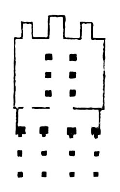
The neighbourhood of Derr is interesting on account of a temple situated on the declivity of a rocky hill, just behind the village. Its structure denotes remote antiquity. The gods of Egypt appear to have been worshipped here long before they were lodged in the gigantic temples of Karnac and Gorne, which are, to all appearance, the most ancient temples in Egypt. The temple of Derr is entirely hewn out of the sand-stone rock, with its pronaos, sekos or cella, and adyton. The pronaos consists of three rows of square pillars, four in each row. The row of pillars nearest the cella, which were originally joined by the roof to the main temple, are of larger dimensions than the rest; they are nearly four feet square, and about fourteen feet high, and are still entire, while fragments of the shafts only remain of the two outer rows. In front of each of the four pillars are the legs of a colossal figure, similar to those of the temple of Gorne, at Thebes. A portion of the excavated rock which had formed one of the walls of the pronaos, has fallen down; on the fragments of it, a battle is represented: the hero, in his chariot, is pursuing his vanquished foe, who retires to a marshy and woody country, carrying the wounded along with him. In a lower compartment of the same wall, the prisoners, with their arms tied behind their backs, are brought before the executioner, who is represented in the act of slaying one of them. All these figures are much defaced. On the opposite wall is another battle, but in a still more mutilated state: in this, prisoners are brought before the hawk-headed Osiris. On the front wall of the cella, on each side of the principal entrance, Briareus is represented in the act of being slain, and Osiris, with uplifted arm, arresting the intended blow. This is the same group which is so often seen in the Egyptian temples; but, Briareus has here only two heads, and four arms, instead of the numerous heads and arms represented in Egypt. On the four pillars in front of the cella, variously dressed figures are sculptured, two generally together, taking each other by the hand. The Egyptian Mendes, or Priapus, is also repeatedly seen. The cella of the temple consists of an apartment thirteen paces square, which receives its light only through the principal gate, and a smaller one, on the side of it. Two rows of square pillars, three in each row, extend from the gate of the cella to the adytum: these pillars show the infancy of architecture, being mere square blocks, hewn out of the rock, without either base or capital; they are somewhat larger at the bottom than at the top. The inside walls of the cella, and its six pillars, are covered with mystic figures, in the usual style; they are of much ruder workmanship than any I have seen in Egypt. Some remains of colour prove that all these figures were originally painted. On one of the side walls of the cella, are five figures, in long robes, with shaven heads, carrying a boat upon their shoulders, the middle of which is also supported by a man with a lion’s skin upon his shoulder. In the posterior wall of the cella, is a door, with the winged globe over it, which leads into the small adytum, where the seats of four figures remain, cut out of the back wall.[22] On both sides of the adytum are small chambers, with private entrances into the cella; in one of which a deep excavation makes it probable that it was used as a sepulchre.
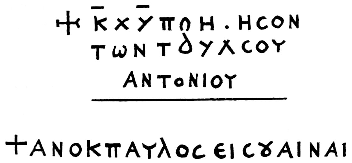
On the side of the mountain, near the temple, are some sepulchral pits excavated out of the rocky ground: over two of them are the following inscriptions, which I copied:
Derr being the principal place in Nubia, and the usual residence of the chiefs, whenever they are not travelling about, is resorted to by strangers, and carries on some commerce. The dates of Derr and Ibrim are much esteemed in Egypt, and the merchants of Esne and Assouan export many ship-loads from hence in autumn, when the height of the waters insures a quick passage down the river. Young date trees are also carried hence to Egypt, as the trees propagated there from seed soon degenerate. The dates are paid for in Dhourra, and in coarse linen and Melayes, of Esne and Siout manufacture; but if the harvest of Dhourra has been abundant in Nubia, the payment is then made in Spanish dollars. The state of commercial intercourse in this country is, however, very bad; dates, for example, bought at Derr, even when paid for in cash, leave, when sold at Cairo, a clear profit, after paying all expenses, of at least 400 per cent. Dhourra, on the contrary, carried from Assouan to Derr, yields there 100 per cent. profit. The hundred weight of dates at Derr is worth about eight shillings. The common currency is the Moud, or small measure of Dhourra, by which every article of low value is estimated. The dollar is rather an article of exchange than a currency. Piastres and paras have only been known here since the invasion of the Mamelouks.
The village of Derr stands in a grove of date trees, and consists of about two hundred houses. Hassan Kashef and his two brothers have each a good house. The greater part of the inhabitants are Turks, the descendants of the Bosnian soldiers who were sent by Sultan Selym to take possession of the country.[23]
March 2d. I departed from Derr with an old Arab, named Mohammed Abou Saad (محمّد ابو سَعد), one of the Bedouins called Kerrarish (قراريش). These Bedouins, a remote branch of the Ababde, pasture their cattle on the uninhabited banks of the river, and on its islands, from Derr southward, as far as Mahass and Dongola, where they are said to be more numerous than in Nubia. They are poor; their tents are formed of mats made of the leaves of palm-trees, with a partition in the middle to separate the women’s apartment; but, notwithstanding their poverty, they refuse to give their daughters in marriage to the Nubians, and have thus preserved their race pure. They pride themselves, and justly, in the beauty of their girls. The Kerrarish are, for the most part, in the service of the governors of Nubia, to whom they are attached as a corps of guards, and guides, and accompany them in their journies through their dominions. Whilst the father and grown up sons are absent, the mother and daughters remain in their solitary tent; for they generally live in separate families, and not in encampments. These Bedouins receive occasional presents from the chiefs of Nubia, and such of them as cultivate the islands in the river are exempted from taxes. They are a very honest and hospitable people, and more kind in their dispositions, than any of the inhabitants of Nubia whom I met with. Those who are not in the employ of the governors, gain their livelihood either by acting as guides, or in collecting the senna in the eastern mountain, which they sell to the merchants of Esne at about £1. per camel’s load (from four to five hundred weight). Numbers of them also travel from Wady Halfa, on the Nile, three days journies into the western desert, and collect there the Shabb, (شبّ) or nitre, which they exchange with the same merchants for Dhourra; giving two measures of the former for three equal measures of the latter. The nitre is found on digging only a few inches deep, and covers a space of several miles in extent. This is, however, a perilous traffic, as the inhabitants of Kubbanýe, a village about twelve miles north of Assouan, also engage in it; these are eleven days in reaching the nitre pits, and whenever the two parties meet, a bloody conflict ensues. Between Wady Halfa and the Shabb, one day’s distance from the latter, is a spring where is some verdure, and where a few Doum trees grow North of the Shabb, one day, in the direction of the great Oasis, is a similar spring, called Nary (ناري), with many date trees growing round it.
After having rode along by the date groves, and well built peasants houses, for about half an hour from Derr, we ascended the eastern mountain, the road along the river side being interrupted by the rocks. On the top of the mountain is a wide plain, covered with small fragments of loose sand-stone; and bordered on the east, at about two hours distance, by a higher range of mountains. We continued along this plain in the direction of W. S. W., until two hours and a half from Derr, when we descended again to the banks of the river, near the village Kette (قتّه), where we crossed the dry bed of a branch of the stream, and alighted on an island, at the tent of my guide, where I remained for the night. These people, who all speak Arabic as well as the Nouba language, are quite black, but have nothing of the Negro features. The men generally go naked, except a rag twisted round their middle; the women have a coarse shirt thrown about them. Both sexes suffer the hair of the head to grow; they cut it above the neck, and twist it all over in thin ringlets, in a way similar to that of the Arab of Souakin, whose portrait is given by Mr. Salt in Lord Valentia’s Travels. Their hair is very thick, but not woolly; the men never comb it, but the women sometimes do; the latter wear on the back part of the head, ringlets, or a small ornament, made of mother of pearl and Venetian glass beads. Both men and women grease their head and neck with butter whenever they can afford it; this custom answers two purposes; it refreshes the skin heated by the sun, and keeps off vermin. The young boys go quite naked; but the grown up girls tie round their waist a string of leather tassels, much resembling the feather ornaments worn for a like purpose by the south sea islanders.
March 3d. I sent my guide back to Derr, to purchase more Dhourra, in order that we might give some of it to the camels, in those places where no wild herbs grow; and on his return we set out. Our road lay along a grove of date trees, and an uninterrupted row of houses, for two hours, when the perpendicular rock reached close to the river. At the height of about sixty or eighty feet above the footpath, I observed from below, the entrance to an apartment hewn in the rock, but without any road leading to it, the rock being there quite perpendicular. In like manner I have seen sepulchres cut in the rock of Wady Mousa in Arabia Petræa, which can only be approached by means of ladders, forty or fifty feet in height. In two hours and a half we reached the castle of Ibrim (ابريم), which is now completely in ruins, the Mamelouks having sustained a siege in it last year, and in their turn besieged the troops of Ibrahim Beg, in the course of which operations, the walls were battered with the few cannon that were found in the castle, and many of the houses of the village levelled with the ground.
Ibrim is built upon an insulated rocky hill, just above the river, and is surrounded by barren mountains entirely incapable of cultivation, on the tops of which are many ancient tombs of Turkish saints. The houses are constructed of loose sand-stone, as is the modern wall which surrounds the town. On the west side are some remains of the ancient wall; this had been built of hewn stones cemented together with great neatness: the stones are rather small. It appeared to me to be an erection of the Lower Empire. Within the area of the town are the remains of two public buildings, probably Greek churches, built in the same style as the ancient wall. The castle is about fifteen minutes walk in circumference. A small gray granite column was the only remnant of antiquity it contained.
The castle of Ibrim, with its territory, which commences half an hour south of Derr, and extends as far as Tosko,[24] is in the hands of the Aga of Ibrim, who is independent of the governors of Nubia; the inhabitants being thus freed from taxes, and paying nothing to their own Aga, had in the course of years acquired, by the annual sale of their dates, great wealth both in money and cattle; but the Mamelouks, in their retreat last year, destroyed in a few weeks the fruits of a century. They took from the Wady Ibrim about twelve hundred cows, all the sheep and goats, imprisoned the most respectable people, for whose ransom they received upwards of 100,000 Spanish dollars; and on their departure, put the Aga to death; their men having eaten up or destroyed all the provisions they could meet with. This scene of pillage, was followed by a dreadful famine, as I have already mentioned.[25]
The people of Ibrim are often at war with the governors of Nubia, and although comparatively few in number, are a match for the latter; being all well provided with fire arms. They are white, compared with the Nubians, and still retain the features of their ancestors, the Bosnian soldiers who were sent to garrison Ibrim by the great Sultan Selym. They all dress in coarse linen gowns, and most of them wear something like a turban: “We are Turks,” they say, “and not Noubas.” As they are not under absolute subjection to their Aga, and independant of every other power, quarrels are very frequent among them. They have a hereditary Kady: blood is revenged by blood; no commutation in money being accepted for it when death ensues; but all wounds have their stated fines, according to the parts of the body upon which they are inflicted. A similar law prevails among the Syrian Bedouins. When a Turk of Ibrim marries, he presents his wife with a wedding dress, and gives her besides, a written bond for three or four hundred piastres, half of which sum is paid to her in case of a divorce. Divorces, however, are very rare. At a wedding a cow or a calf is killed; for to eat mutton upon such an occasion would be a great scandal to the spouse.
In no part of the Eastern world, in which I have travelled, have I ever found property in such perfect security as in Ibrim. The inhabitants leave the Dhourra in heaps on the field, without a watch, during the night; their cattle feed on the banks of the river without any one to tend them; and the best parts of the household furniture are left all night under the palm-trees around the dwelling; in short, the people agreed in saying, that theft was quite unknown in their territory. It ought, however, to be added, that the Nubians, in general, are free from the vice of pilfering.
From Ibrim we crossed the mountain, and at one hour’s distance from it descended to the river side, at Wady Shubak (شُباق), whither most of the inhabitants of Ibrim retired, after the passage of the Mamelouks. We slept here, at the house of the children of the Aga whom the Mamelouks murdered. Wherever I alighted, a number of peasants assembled, in the evening, at the house; I always gave out that I had business of a public nature with the two chiefs, who were stationed to the south of Sukkot, and being accompanied by a man known to be attached to the Kashefs, no one dared to create the least obstacle to my journey. Indeed, travellers in Nubia, in general, have little to fear from the ill will of the peasants; it is the rapacious spirit of the governors that is to be dreaded.
March 4th. The grove of date trees continues to the south of Shubak. I found many of the houses abandoned; and at every step were graves. The Nubians place an earthen vessel by the side of every grave, which they fill with water at the moment the deceased is interred, and leave it there: the grave itself is covered with small pebbles of various colours, and two large palm leaves are stuck into the ground at either extremity; the symbol of victory thus becoming, in Nubia, that of death. Near Shubak are some mounds of hewn stones, indicating the remains of an ancient edifice. One hour from Ibrim brought us to Wady Bostan (وادي بُستان). The soil, fit for culture, is here very narrow; the eastern mountain is distant about one hour; between it and the plain is a rising spot of ground covered with loose sand-stones. The shape of the insulated mountains which compose this part of the chain, is remarkable; most of them resembling cones flattened on the top, or perfect pyramids; and when viewed from afar, they appear so regular, that they seem to be the work of man. In two hours and a half we came to the village of Tosko (تسقه), the southern limits of Wady Ibrim. In the rocky plain east of Tosko stands an insulated, shattered rock, with several sepulchres excavated in it; these are supported on the inside by low square pillars: in one of them, a vaulted passage leads out to a back entrance. They are of very rude workmanship; and have no sculptures upon the walls, except the figure of the cross. Near the rock are considerable mounds of rubbish. It is matter of surprise, that these are the only sepulchres met with in the eastern hills, from Assouan to this place: the sand-stone rock might have easily been excavated, as has been done in numerous places in Egypt. Tosko continues for about one hour. Three hours and a half, passed over the mountain. Four and a half, Ermenne (ارمنّه), a fine village, belonging to the territory of Nubia. Our road had been till now, in the direction of S. W. From hence, southward, we travelled W. S. W. Five hours and a half, again passed over the mountain, which is close to the river. Six hours, Formundy (فرمندي), a poor village, extending for several miles. The Nubians here grow a little cotton, small plantations of which are every where met with from Kenne, in Upper Egypt, as far as Dongola. The women weave the cotton into coarse shirts, or sell it for Dhourra to the merchants of Derr. Seven hours and a half, we passed the ruins of a Greek church, which had been used in later times as a mosque. Its walls, for half their height, are constructed of small stones, and the upper part of bricks burnt in the sun; there are many names of visitors written on the white plaister; the writing is of the latest time of the Lower Empire. The river here has many windings; and this part of it is reputed a favourite haunt of the crocodile. I saw myself half a dozen of them lying close together on a sand-bank. All the Nubians, as well as the people of Upper Egypt, eat the flesh of this animal whenever they can catch it, which is, however, very seldom.[26]
Beyond the Greek church, the road again crosses the mountain, on the other side of which, at eight hours and a half, is the Wady Fereyg (فريك). The different villages comprised under the collective term Wady, are generally separated from the Wadys on their northern or southern side by a part of the mountain projecting close to the river, which thus forms a natural division. Nine hours and a half, long after sunset, we alighted, at the house of one of the wives of Hassan Kashef, where I slept. Our day’s march, reckoning by the length of the day, must have been at least ten hours and a half. My watch had unfortunately stopped, from the dust having penetrated into it. My day’s march in Nubia is therefore calculated only by the sun’s height, and the length of the day; I may have in this way erred as to partial distances from one village to another; but the entire day’s route will generally be found correct.
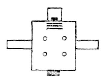
March 5th. In half an hour we arrived at the Akabe[27] of Fereyg, or the place where the mountain separates that Wady from its southern neighbour. I sent my guide, with the camels, over the mountain; and following a narrow foot-path along the almost perpendicular shore, I arrived, at one hour’s distance from Fereyg, at an ancient temple hewn out of the rocky side of the mountain; no other road leads up to it but this dangerous foot-path, neither are there any traces of an ancient road. I entered through a high narrow gateway into a small Egyptian temple, cut entirely out of the rock, and in as perfect a state of preservation, as when first finished. It consists of a cella, ten paces in length and seven in breadth, and about twelve feet high. Within it are four columns, with Egyptian capitals. On either side of the cella is an apartment which receives light only by the entrance from the cella. Low stone benches run along the walls of the cella, a peculiarity which I had not seen in any other Egyptian temple. There is an ascent by three low steps from the cella into the adytum, in which is a deep sepulchral excavation; there is also a similar but smaller one in the cella itself. The walls both of the cella and adytum are covered with mystic sculptures in the usual style, but there are none in the two side chambers. The Greeks had converted this temple into a church, and had plaistered the walls white, to receive their paintings, many of which still remain; a St. George killing the dragon is particularly conspicuous. Many Greek travellers have inscribed their names on the walls. The whole fabric is of coarse execution, and the hieroglyphics much in the same style as those at Derr. On the opposite side of the river, a little to the north of it, is the large temple of Ebsambal, and the colossal figures, of which I shall speak hereafter.
One hour and three quarters from Fereyg, I rejoined my guide, at the foot of an insulated hill, close to the water, on which a castle has been built, resembling in size and form, that at Ibrim; it bears the name of Kalat Adde (قلعت ادّه); it has been abandoned many years, being entirely surrounded by barren rocks. Part of its ancient wall, similar in construction to that of Ibrim, still remains. The habitations are built partly of stone and partly of bricks. On the most elevated spot in the small town, eight or ten gray granite columns of small dimensions lie on the ground, with a few capitals of red sand-stone near them, of clumsy Greek architecture. The rock of this hill is a fine pudding-stone, of flint, quartz, and red sand-stone; the only specimen of the kind I have met with in Nubia. Opposite the castle, the river forms a large island, called Beyllany (جزيرة بيلاني), from the name of the village nearest to it, on the western side. The mountain round Adde is composed of rugged hills of grotesque shape, which seem to have been shattered by some violent commotion of nature. From hence, upwards, the course of the river is W. S. W. Two hours and a half from Fereyg, the eastern mountain branches out far to the eastward, and closes with the river again beyond the second Cataract of Wady Halfa. The wild shrub, Oshour (عشور), called by the Arabs of the Dead Sea, Asheyr (عشير), grows here in great quantity. This plant produces a fruit, within which is a bunch of silky fibres enveloping a small bean. It has been described by Norden. It grows in every part of Upper Egypt, south of Siout, in sandy spots near the river; but is not so large there as it is in Nubia; the Egyptians call it Fetme (فتمه). From Silsilis (south of Edfou) to the district of Mahass, it is the most common weed met with on the road: its leaves are poisonous to the camels. The Coloquintida (حَنضَل) is likewise frequently met with, where the Oshour grows. Like the Arabian Bedouins, the Nubians make tinder of it.[28] At the end of three hours we passed, in the sandy plain, a number of tumuli, or barrows, of various sizes, covered with sand: I counted about twenty-five within the circuit of a mile and a half: the regularity of their shape, which is exactly the same as that of the tumuli in the Syrian deserts, and the plain of Troy, makes it almost certain, that they are artificial. Three hours and a half, Kosko, a small village. Four hours, the large village of Endhana, also called Adhendhan (انضانا—اضنضان). In riding along, we were invited to a funeral feast by the inhabitants of a house belonging to some relation of the Nubian princes; the possessor had died a few days before at Derr, and on receiving the news of his death, his relations here had slaughtered a cow, with which they were entertaining the whole neighbourhood; at two hours distance from the village, I met women with plates upon their heads, who had been receiving their share of the meat. Cows are killed only by people of consequence, on the death of a near relation; the common people content themselves with a sheep or a goat, the flesh of which is equally distributed; the poorer class distribute some bread only at the grave of the deceased. Four hours and three quarters; upon the hill, at the south end of Wady Endhana, opposite the village of Faras, on the west side of the river, stands an ancient ruined mosque. Five hours and a half, passed the fine island of Faras. The country is here open, but the plain, on both sides of the river, is covered with sand. Seven hours, the village Serra gharby (سرّه غربي) on the west side. Seven and a half, the ruins of a small Arab town close to the water, enclosed by a thick brick wall. Eight hours, Serra (سرّه), a fine village; eight and a half, Debeyra (دبَيرهَ), where I slept. My guide always conducted me to the house of the principal person in the village; we should otherwise have often gone supperless to rest. Wherever we alighted, a mat was spread for us upon the ground, just before the gate of the house, which strangers are never permitted to enter, unless they are intimate acquaintance. Dhourra bread, with milk, was our usual supper; to this were sometimes added dates. The landlord never eats with his guests, except when earnestly pressed to do so. Our camels were not always fed by our hosts, who excused themselves, by saying that the stock of Dhourra stalks was already exhausted. If the stranger is to be well treated, a breakfast is brought in, at sunrise, before he departs; it consists of hot milk and bread, the supper being usually cold: but we were seldom so fortunate as to get a breakfast, and generally rode the whole day without tasting any thing but a few dates from our own stock, at some spot where we stopped in the morning to bait our camels upon the tamarisk or acacia trees.
March 6th. Our road lay over a fertile plain, covered with date trees and habitations, to Eshke (اشقه). The Nile had been so very low last year, that the plain had not been inundated. An old man, a relation of the governors of Nubia, on seeing me pass by his house, invited me to stop, and entertained me most hospitably. He had been, in his youth, governor of Sukkot, where he had acted with great tyranny; but he seemed to have repented of his former deeds, and was now become the benefactor of Eshke. A handful of burnt coffee, which I gave him, was a most acceptable present, and he insisted upon my staying with him one day, promising that he would cause a lamb to be killed for me; but this did not appear to me a sufficient temptation to retard my journey.
The slave caravan from Mahass, which I mentioned above, passed along the west bank of the river, while I was at Eshke; the usual route of these caravans, which generally visit Egypt twice in the year, lies across the desert, from Mahass to the Great Oasis, a journey of twenty-three days; and from thence to Siout and Cairo. It was only this year that the slave-traders, informed of the perfectly tranquil state of Nubia and Upper Egypt, had ventured to proceed along the banks of the Nile, a road they had not followed in the memory of man.
To the south of Eshke is a sandy plain; in three hours, we reached Dabrous (دَبروس); the direction of the road S. W. by S. Four hours, Sukoy (سَقوي). Five hours, Wady Halfa (وادي حلفه), to the east of which, the eastern mountain terminates in slight undulations of the ground; but these increase in size, and collect again into mountains, about thirty miles farther up. There is some trade carried on at Wady Halfa; vessels from Assouan often moor here to load dates, and the nitre which the Arabs collect at three days journeys from hence in the western desert.[29] In summer, the navigation from Derr to Wady Halfa becomes, in many places, very difficult, except for small boats, on account of the sand banks. One of the relations of the governors of Nubia resides here, and collects the revenue.
At the end of six hours, we came to the southern extremity of Wady Halfa. The river forms here several islands, upon one of which are the remains of an ancient town, built of bricks, with a high brick wall. Seven hours, the plain over which we rode became uneven, and studded with insulated clusters of rocks, whose summits just appear above the surface of the sand. To the west is the second Cataract. Eight hours, halted for the night, in this desert, near one of the islands, which are formed by the river. The noise of the Cataract was heard in the night, at about half an hour’s distance. The place is very romantic; when the inundation subsides, many small lakes are left among the rocks; and the banks of these, overgrown with large tamarisks, have a picturesque appearance amidst the black and green rocks; the lakes and pools thus formed cover a space of upwards of two miles in breadth. I here shot a wild-goose, which afforded a supper to our party, now increased by the company of a poor young girl from Dabrous, who ran after us, when she saw us pass by, and begged we would take her under our protection as far as Wady Mershed, beyond the Cataract. From Wady Halfa to Sukkot is a stony wilderness, with many cataracts in the river, similar to that at Assouan; and the navigation is interrupted for about one hundred miles. This rocky tract is called Dar el Hadjar, or Batn el Hadjar, i. e. the rocky district, or the “womb of rocks.”
March 7th. After a march of one hour, the straggling hillocks and mounds rose into a low chain of hills, the road amongst them being a perfect sandy plain. In one hour and a half we came to Wady Amka (وادي عَمقه). In the Batn el Hadjar, there occur a few spots that admit of cultivation; but they consist of very narrow strips of plain by the side of the river, where the banks are generally so high, that the waters do not reach them during the inundation, and where the soil must consequently be irrigated, by means of water-wheels. These narrow plains, called Wady, as in other parts of the country, were formerly well cultivated. Their principal inhabitants pretend to be Sherifs from Mekka, and to have come here at the time of the invasion of the other Arab tribes. They have a chief named Abdallah Ibn Emhyd (عبدالّه ابن امهيد), who resides in Wady Attar,[30] and is honoured with the title of Melek, or king, which is bestowed on chiefs of all ranks from hence southward. These Sherifs, called Omsherif (اُم شريف), pay a small tribute to their Melek, and the Melek is tributary to the governors of Nubia, who besides carry off as much of the property of these Arabs as falls in their way, whenever they pass along the Batn el Hadjar. The greater part of the Sherifs, however, have now quitted their abode, owing to the continued incursions of the Arabs Sheygya (شَيِكيعَ), who live on the banks of the river, south of Dongola, eight days journeys distant from Sukkot, across the desert; and whose depredations have so much ruined the Sherifs, that the greater part of them have retired to Sukkot, and many of them to Dongola. At present, the male inhabitants in the whole district of Batn el Hadjar hardly amount to two hundred, half of whom are Sherifs, and the other of the Bedouin tribe of Kerrarish. Some Arabs remain at Amka; and a small village is built upon a rocky island, where are the ruins of a large brick tower; from hence the Arabs cross the branch of the river every morning, (upon the trunk of a palm-tree, using their hands as paddles) for the purpose of cultivating their fields upon the shore, and return in the evening in the same manner. As we advance the river continues to be full of rocks and islands, and the country has a very wild aspect. There is no place that so much resembles the Batn el Hadjar and its Wadys, as the road along the Nile from Assouan to the first Cataract; the same rocky shore, with here and there the same narrow strip of soil, continues all along “the womb of rocks,” from Wady Halfa to Sukkot.
At two hours and a half, is Wady Mershed (مرشد). The Wadys are separated from each other by rocky tracts, which reach close to the river. At Wady Mershed there are again numerous islands in the river; upon two of them are some brick ruins, an ancient tower, and a few huts of Arabs. Our route from Wady Halfa to Mershed had been W. S. W. Above Mershed, the river is free from islands, and few rocks are seen in it; but its bed is very narrow, and the banks are high: I could throw a stone over to the opposite side. Four hours and a half brought us to Sette Hadje, a cultivable patch of ground, enclosed by rocks, with some ancient brick dwellings; it is inhabited only by an old Arab, who lives in the hut constructed over the tomb of the female saint called Sette Hadje, and who owes his livelihood to the charity of passengers: I found him extended upon his mat, with a pot of water, and an earthen vessel near him, into which I put a few handfuls of dates. From hence southwards, the river has many windings. The hills on the east side increase in height until eight hours and a half, at Wady Seras (سِراص), when they again form a regular chain of mountains, over which lies the road from Wady Sette Hadje. My old Arab guide, afraid of robbers from among the Sheygya Arabs, who are continually hovering about in these parts, to waylay travellers, hurried me along as fast as he could. We met very few persons on the road, excepting small parties of five or six Soudan pilgrims, or Tekayrne (sing. Tekroury); these courageous travellers come from all parts of Soudan to Darfour, from whence they proceed either by Kardofan to Sennaar, or direct to Dongola. From the Nile some of them take the route of Suakin, crossing the Red Sea, from thence to Djidda; others follow the Nile through Dongola and Mahass, and perform their pilgrimage with the Egyptian Hadjis, after having remained some time in the mosque El Azhar at Cairo, occupied in reading the Coran and a few books of prayers. I found, upon subsequent enquiry, that the greater part of these pilgrims were natives of Darfour, and Bergho. Among more than forty whom I spoke to at Esne, I could not find one whose country was as far west as Kashna; but I met with several who came from Wangara. The name Tekroury is given to them, I suppose, from their being natives of the district of Tekrour in Soudan. Such of them as can read and write are called Fókara (plur. of Fakyr), a term applied in Upper Egypt to all learned persons, by which is meant, such as can read the Coran, and who know how to write talismans, for preservatives against charms, and spells of the devil.
Nine hours and a half, we stopped at the southern extremity of Wady Seras, at a hut of Kerrarish Arabs, who, together with a family of the Sherifs, were watching the produce of a few cotton fields, and bean plantations. They gave us some milk for supper, assuring us that they had no bread, and that they had not even tasted any for the last two months. I distributed a measure of Dhourra amongst them, upon condition that they should not exchange it for any thing else, but make bread of it for themselves and their women, for the latter very seldom enjoy this luxury, which is almost exclusively reserved for their husbands and brothers. In consequence of my present, the women were all set to work to grind the Dhourra between two granite stones, for the richer class only have hand-mills (رحا), like those of the Arabian Bedouins. Plenty of bread was then made, and the girls sat up, eating and singing, the whole of the night, and being separated from us only by a partition formed of tamarisk branches, they often joined in the conversation. The leaves of beans, and the grain of the shrub Kerkedan, which is black, and resembles in size the coriander seed, form the food of these people. The Kerkedan grows wild in the Batn el Hadjar, and is sown in some parts of Northern Nubia; a coffee is made from the roasted grains, which is not disagreeable to the taste, but the Arabs more usually make bread of them. The leguminous shrub Symka is also very common here, and affords excellent food for camels; it produces a pod, resembling pease, and containing several round rose coloured grains, which are edible, when green; these the Arabs collect and dry, and by hard boiling, obtain from them an oil, which they use, instead of butter, to grease their hair and body.
The Sherifs of Batn el Hadjar are of the darkest brown colour, with fine features, and are remarkably well made. Both men and women go naked; but the latter wear leather amulets round the neck, copper armlets and bracelets, and silver ear-rings. Most of them speak a little Arabic.
March 8th. From Seras we ascended a high mountain. The rock, which had been everywhere sand-stone as far as Wady Halfa, changes its nature at the second Cataract, where grunstein and grauwacke predominate; these primitive rocks continue throughout the Batn el Hadjar. In the mountain beyond Seras are granite, and immense rocks of quartz: the grunstein rocks are also every where crossed by strata of quartz. Three or four hours east of our route, a high chain of mountains extends parallel with the course of the river; it bears the name of Djebel Bilingo (جبل بَلَنكو), and is uninhabited: it is regularly visited by winter rains, and the water remains in the clefts and hollows the whole of the summer. In two hours and a half we came to a plain on the top of the mountain, called Akabet el benat (عقبة البنات), the rocks of the girls. Here the Arabs who serve as guides through these mountains have devised a singular mode of extorting small presents from the traveller: they alight at certain spots in the Akabet el benat, which they call قبضه or مقبضه, and beg a present; if it is refused, they collect a heap of sand, and mould it into the form of a diminutive tomb, and then placing a stone at each of its extremities, they apprize the traveller that his tomb is made; meaning, that henceforward, there will be no security for him, in this rocky wilderness. Most persons pay a trifling contribution, rather than have their graves made before their eyes: there were, however, several tombs of this description dispersed over the plain. Being satisfied with my guide, I gave him one piastre, with which he was content. On the southern descent of Akabet el benat, the principal rock is micaceous schist and chlorite, and farther down, towards the Wady Attyre, fine porphyry rocks are met with. I saw only a few specimens of green porphyry, with red slabs of feldspath; the greatest part being red porphyry, and porphyry schist. I possess specimens of all these rocks. From Seras, our route lay S. W. by S. Four hours and a half, Wady Attyre (التّيره), the principal village in the Batn el Hadjar. Here again, there are several islands in the river, with ruins of ancient brick habitations and towers upon them. The shores seem to have offered little security, even in ancient times, for I met with no ruined buildings on the eastern bank of the Batn el Hadjar; the ancient inhabitants seem to have exclusively chosen the islands for their abode. There is another cataract in the river at Wady Attyre, and a similar one between that place and Seras, opposite to Samne, on the west bank. We continued in the Wady Attyre upwards of an hour. Some date trees grow in all these Wadys, but the Doum is more common. At five hours, a wild passage across the mountain begins, called Akabet Djebel Doushe (عقبة جبل دوشه). From the top of it I enjoyed a beautiful view of the course of the river to the southward; but its narrow verdant banks are almost lost in the wide expanse of the rocky desert, where the eye, fatigued by the view of the dreary wilderness, searches with difficulty for the blue stream, often hidden by islands, and only appearing partially. Its course from hence is S. W. by S. At seven hours, we descended from the mountain into Wady Ambigo (اَمبقُو). At eight hours, were several cataracts, where the stream rushes impetuously over the rocks, and carries its foaming current to the distance of several hundred feet; there is no where, however, any fall, that can be properly so called. All these cataracts resemble those of Assouan, but the river is more narrowly hemmed in by rocks than at the latter place; and its whole course through the Batn el Hadjar is so very rapid, that navigation of every kind seems to be quite impracticable. At the end of nine hours, we stopped at a hut of Omsherifs.
March 9th. To the east of Ambigo, there are high mountains; and to the south of it, the eastern chain decreases in height. The mountains of Ambigo seem to be the highest summit of the Batn el Hadjar. Our road lay alternately along the shore, and over the rocks; I no where saw any traces of an ancient road through this rugged district. In three hours we reached Wady Om Kanaszer (اُم قناَصِر), in which is a small watch-tower built of stones, upon a hill. From hence we followed a mountainous road as far as Wady Lamoule (وادي لاموله), which we reached in five hours; here are some cataracts in the river, and several rocky islands, upon which I saw crocodiles basking. At five hours and a half, we ascended the mountain; and in six hours gained a high summit, known by the name of Djebel Lamoule (جبل لامولَه), and corresponding with a similar one on the west side. At the foot of this hill, the Arabs repeat the custom of digging the traveller’s grave, but as I knew not how often a present might in this way be demanded of me by my guide, I refused to give him any thing upon his making the demand; and as soon as he began to construct my tomb, I alighted, and making another, told him that it was intended for his own sepulture; for that, as we were brethren, it was but just that we should be buried together. At this, he began to laugh; we then mutually destroyed each other’s labours, and in riding along he exclaimed from the Coran, “No mortal knows the spot upon earth where his grave shall be digged.” Seven hours brought us to a sandy plain in the mountain, called Khor Sonk (خور سُنك), Sonk being a Wady, situated below it. As the road which leads to the country of the Sheygya turns off here, this spot is more frequently visited by them, than any other part of this rocky tract, and is noted for the many robberies committed here by those Arabs; my guide shewed me the place where his cousin had been killed, at his side, in an encounter with the Sheygya, and hurried me, at a full trot, over the plain. The whole of the Batn el Hadjar is dangerous for single travellers; but it was my good fortune not to meet with any banditti; should any European be inclined to make the same journey hereafter, he may procure at Derr as many guards to accompany him as he chooses, provided he previously arranges matters with the governors of Nubia.
At eight hours and a half we issued from the mountains, and crossing a sloping plain, arrived, at the end of nine hours and a half, at the side of the river. The country opens here, and the eastern chain continues at about two miles distance from the river. At ten hours and a half, we halted for the night in a thick grove of tamarisk trees, opposite a long island, upon which are several brick ruins, and a tower of the same material. The ruins of a small village are upon the east bank: the place is called Wady Okame (عقمه); and here the dominions of the governor of Sukkot begin, although the Wady is considered to belong to the Batn el Hadjar. Close to the spot on which we slept is the tomb of a saint, Sheikh Okashe (شيخ عُقاشه), much revered by the Nubians. Offerings of earthen vessels, mats, and small pieces of linen, were spread within the enclosure of the tomb, and all around it. The inhabitants of Sukkot make frequent pilgrimages to this tomb. My guide, in constant dread of the Sheygya, would not allow me to light a fire, although the nights were now very cold.
March 10th. After a ride of two hours over low hills, in a S. S. W. direction, we arrived opposite the island of Kolbe (قُلبه), the northern extremity of Sukkot, and the residence of the governor of that district;[31] the island is about one hour in length: the shore, on both sides, is hemmed in by huge masses of gray granite. Here some regular cultivation commences. I had a letter of recommendation from Hassan Kashef to the governor, who is an old man, named Daoud (David) Kara, distantly related to the three chief governors of Nubia, under whose control he holds his district. Being desirous of paying him a visit, in order to gain some information from him respecting the state of things farther southward, I left my guide to watch the camels, and with some Arabs, who had arrived at the place where we alighted, crossed the river upon a Ramous (راموس). This kind of ferry boat is formed of four trunks of date-trees, tied loosely together, and is worked by a paddle about four feet in length, forked at the upper extremity, and lashed to the raft by ropes of straw. It precisely resembles those which are represented on the walls of the Egyptian temples. Persons who trust themselves upon such frail vehicles should be able to swim, for as these people have no idea of skulling, and use only one paddle to each Ramous, they row alternately to leeward and windward, so that the Ramous is never directed towards the shore. The old governor received me coolly; “This is not a country,” he said, “for people like you to travel in, without being accompanied by caravans.” I requested a letter of introduction to his son, who governs the southern parts of Sukkot, when he caused his scribe[32] to write a few lines for me upon a blank corner of an old letter, the only paper that could be found. He repeatedly enquired my business; I answered, that I was the bearer of letters from Esne to the two Kashefs, who were at Mahass. After a stay of one hour I retired, recrossed the river, and continued my journey. We rode over mountainous ground, where the sand-stone again appears among the grauwacke and feldspath, until, at two hours and a half from Kolbe, we reached Wady Dal (وادي دال), which may be called the southern extremity of the Batn el Hadjar. At Dal the river is interrupted by immense blocks of granite lying confusedly across it, occasioning several foaming cataracts, and forming many rocky islands; upon one of these is a large brick building, in ruins. Here the country opens, and we continued for half an hour along a cultivable shore, overgrown with date trees, amongst which was a ruined village, called Dabbe. One hour farther, still following the plain by the side of the river, we arrived at the village of Zergamotto (زرقَمطو), where we slept. The inhabitants of Zergamotto bring rock salt from Selyma, distant two long days and a half in the western desert, and a halting-place of the Darfour caravan, in its way to Siout. Whenever this caravan passes Selyma, the Nubians resort thither, to sell dates and other provisions to the travellers. Rock salt is found also in every part of the eastern mountain from Kenne southward, and the peasants of Egypt and Nubia collect it; but it has a very disagreeable bitterish-sweet taste.