J. E. MARR, M.A., F.R.S. (continued 2)
Reading edition
To take actual examples:—The Llandovery beds of Dumfriesshire can be subdivided into several minor divisions each of which can be recognised in the Lake District of England, and to a large extent in Scandinavia and elsewhere, for the deposits in these areas are of deep-water character, and the sub-faunas of the subdivisions are similar in the different areas, but the Llandovery rocks of the Welsh borderland are shallow-water deposits, with a different fauna from that of the deep-water deposits of this age, and can only be stated to be contemporaneous with the Llandovery rocks elsewhere, because the deeper-water faunas of the underlying Bala rocks and overlying Wenlock rocks of the Welsh borders are respectively similar to those of the Bala and Wenlock rocks of the other regions. The shallow-water Llandoveries of the Welsh borders have only been separated into two divisions, upper and lower, and have not been split up into a number of subdivisions, each characterised by a sub-fauna, and each comparable with one of the subdivisions of Dumfriesshire, Lakeland and the other regions where the deep-water facies is found.
It will be seen that though the principle of William Smith that strata can be recognised by their included organisms has been extended since his time, and shown to apply to far smaller subdivisions of the strata than was suspected, the method of application is the same, and is more or less successful according to the amount of evidence which is accumulated in support of it.
CHAPTER VI.
METHODS OF CLASSIFICATION OF THE STRATA.
Earth-history like human history is the record of an unbroken chain of events. The agents which have produced geological phenomena have been in operation since the earth came into existence. Accordingly a perfect earth-history would be written as a continuous narrative, just as would a complete history of the human race. The historian of man finds it not only convenient but necessary to divide the epoch of which he is writing into periods of time, and so does the geologist, and in each case the division is necessarily more or less arbitrary. It is true that in writing the history or geology of a country, marked events stand out which form a convenient means of making divisions, but the marked events occurring in one country are not likely to take place simultaneously with those of another country, and consequently a classification of this character is only locally applicable.
The classification which is at present used by geologists was originally founded upon definite principles, and although our principles of classification have, as will appear, been somewhat altered subsequently, it has been found more convenient to modify the original classification than to adopt a new one in its entirety.
The largest divisions into which the strata of the geological column were separated were instituted because of the supposed extinction of faunas, and sudden or rapid replacement by other faunas of an entirely different character. This supposed rapid extinction and replacement is now known to have been only apparent and due to observation in restricted areas, and it is doubtful whether the three great divisions founded upon them are not rather mischievous than useful, as tending to disseminate wrong notions.
Moreover there is considerable diversity of opinion as to the terms to be adopted. The rocks were formerly divided into Primary, Secondary, and Tertiary. Owing chiefly to the use of the term Primary in another sense, the alternative titles Palæozoic, Mesozoic and Cainozoic (or Cænozoic) were suggested, and though the term Primary has been definitely abandoned in favour of Palæozoic, the words Secondary and Tertiary are used extensively as synonyms of Mesozoic and Cainozoic. It was soon perceived that the period of time included in the Palæozoic age was much longer than the combined periods of Secondary and Tertiary ages, and it was proposed to group the latter under one title Neozoic, whilst another suggestion was to split the Palæozoic age into an earlier Proterozoic and later Deuterozoic division. The interest excited by the advent of man is probably the cause of the attempt to establish a Quaternary division, which some hold to be a minor subdivision of the Tertiary, whilst others would separate it altogether. The terms Palæozoic, Mesozoic (or Secondary) and Cainozoic (or Tertiary) are now used so generally that any attempt to abolish them would be doomed to failure, but it must be remembered that they are purely arbitrary expressions, and the other terms which are not in general use, might be dropped with advantage.
The other subdivisions have been used somewhat loosely, and although an attempt has been made by the International Geological Congress to restrict certain names to subdivisions of varying degrees of value, it will probably be found best to allow of a certain elasticity in the use of terms, merely agreeing that they shall be used as nearly as possible with the signification assigned to them by the Congress. According to this classification, and apart from the division into Palæozoic, Mesozoic and Cainozoic, the strata of the geological column are grouped into Systems, which are subdivided into Series, and the series are further split up into Stages. A number of chronological terms were also suggested, of equivalent importance, thus the beds of a system would be deposited during a Period, those of a series during an Epoch, and those of a stage during an Age[15].
The rocks of the Geological Column were originally divided into systems, owing to the occurrence of marked physical and palæontological breaks between the rocks of two adjacent systems, except in cases where a complete change occurred locally in the lithological characters of the rocks of two systems which were in juxtaposition: it is necessary to consider for awhile the nature of these breaks.
The most apparent physical break is where the rocks of one set of deposits rest unconformably upon the rocks of another one, indicating that the older set has been uplifted and to some extent eroded before the deposition of the strata of the newer set. This uplift and erosion signifies a change from oceanic to continental conditions in the area in which unconformity is found on a large scale, and accordingly a long period of time would elapse during which the continental surface would not receive deposits, so that the highest rocks of the underlying system would be considerably older than the lowest rocks of the one which succeeds it. Such a break may be obviously utilised for purposes of classification, but as some areas of the earth's surface must have been occupied by the waters of the ocean when other regions formed land, deposit in some areas must constantly have occurred simultaneously with denudation in others, and any classification founded upon the existence of unconformities will therefore have a purely local value.
Another, and less apparent physical break, which will also be locally applicable, may be due to the depression of an area to so great a depth that little or no deposit was formed upon the ocean floor there during the period of great depression; but as a break of this character is difficult to detect, the existence of unconformities has alone been practically utilised as a means of separating strata into systems owing to marked physical change, except in the cases where the lithological character of the strata completely changes, as between the Triassic and Jurassic rocks of England.
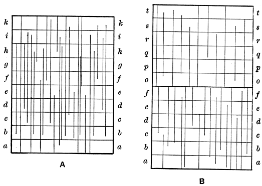
Fig. 2.
Palæontological breaks or breaks in the succession of organisms are in many cases, the result of physical breaks, and accordingly it is often possible to separate one set of strata from another by the existence of a combined physical and palæontological break between them. It is by no means necessary however that a physical break should be accompanied by a break in succession of the organisms, and the latter may also occur without the former. It was once maintained that a palæontological break was due to the complete and sudden extinction of a fauna and its entire replacement by a new one, but this is far from true, and accordingly the breaks differ in degree. Study of the strata shows that when the succession is not to any extent interrupted, the species do not appear simultaneously, but come in at different horizons, and they disappear in the same way. In Figure 2 let A represent a set of conformable strata ab ... k, and suppose the vertical lines represent the ranges of the various species found in these strata. It will be seen that of 27 species whose range is shown only 2 pass through the whole thickness, so that the fauna of k is very different from the fauna of a, nevertheless the fauna of each stratum is closely similar to that of the underlying as well as to that of the overlying stratum, and though most of the species of k are different from those of a, this need not be the case with the genera. The fauna of the set of strata would contain every species whose range is represented, and for convenience' sake it might be said to be composed of sub-faunas, one of which occurs in each division ab ..., but the separation into sub-faunas would be artificial and merely for convenience' sake, for there is no break between any two sub-faunas. Turning now to B (Fig. 2), an attempt is made there to show what happens when there has been a physical break, resulting in the denudation of the strata ghik, and the deposition of another set op ... unconformably upon those deposits of the earlier set which have not been denuded. As the result of this we note, first, that the relics of organisms which existed in the area during the deposition of ghik, and were entombed in those strata, are destroyed by the processes of denudation, and a large number of organisms which lived long after the deposition of f, and disappeared not simultaneously but at different times during the period when denudation was in operation, seem to become extinct simultaneously at the top of f, though, if we could visit an area which was receiving sediment during the period of denudation, we should find them dying out in the rocks of that region at different levels. Furthermore, whilst denudation is going on, a longer or shorter period of time elapses, during which the upheaved area receives no deposit, and accordingly no organisms which lived during that period are preserved in the upheaved area. During this time a set of deposits lmn may have been laid down elsewhere, and besides the gradual disappearance of some of the organisms of ab ... k, there will have been a gradual appearance of new species. When the upheaved area is once more submerged, a new set of deposits op ... is accumulated in it, and the species which gradually appeared in adjoining regions will now migrate to it, and will seem to come in simultaneously at the bottom of o; accordingly we may find that there is not a single species which passes through from f to o and the palæontological break in this area is complete, though it is clear that it only implies local change, and that we may and indeed must find intermediate forms in other regions which fill up the gap.
As an illustration of the local character of a palæontological break we may cite the case of the Carboniferous and Permian systems of Britain. These rocks are separated from one another in our area by a physical and palæontological break, but in parts of India, and other places, we find a group of rocks now known as the Permo-Carboniferous rocks which contain a fauna intermediate in character between those of the Permian and Carboniferous systems, and a study of this fauna shows that the hiatus which exists locally is filled by the species contained in the Permo-Carboniferous rocks.
A palæontological break may, like a physical one, result from depression of the ocean-floor to so great a depth, that no organisms are preserved there during the period of great depression, and the remarks made concerning a depression of this nature when speaking of physical breaks will apply here also.
A local palæontological break may result owing to physical changes without the production of an unconformity in the area, or its submergence to a great depth, or if an unconformity is found, the break may be more marked owing to other physical changes. The difference between the Upper and Lower Carboniferous faunas is very marked in England, where the Upper Carboniferous beds were deposited under physical conditions different from those of the Lower Carboniferous, and accordingly the corals, crinoids and other open-water animals which flourished in Lower Carboniferous times are rare or altogether absent in the higher rocks. Where the change of conditions did not occur to a great extent as in parts of Spain and North America, the similarity between the two faunas is much more pronounced. Again, there is an unconformity between the Cretaceous and Eocene beds of England, which is accompanied by a palæontological break, but this break is more pronounced owing to difference of physical conditions, for we find abundance of gastropods in the lower Tertiary beds, and a rarity of these shells at the top of the chalk of England, though where physical conditions were favourable for the growth of gastropods, their shells are found in the higher strata of chalk age, and the palæontological break is not so apparent.
A palæontological break may occur also as the result of climatic change, though actual instances of this occurrence are much more difficult to detect owing to the general absence of any evidence of climatic change other than that supplied by the organisms themselves. Still, when no physical break exists, and the lithological characters of a group of sediments remain constant throughout, indicating the prevalence of similar physical conditions through the period of deposition of the sediments, if the fauna suddenly changes, there must have been cause for the change, and in the absence of any other cause which is likely to produce the change, alteration of the character of the climate may be suspected.
It follows from the observations which have been made, that although the rocks of the Geological Column may be divided into systems owing to the existence of physical and palæontological breaks, and this classification may be and has been applied generally, the line of demarcation between the rocks of two systems will be a purely conventional one, where there is no break, and, to avoid confusion, that line when once drawn should be adopted by everyone, unless good cause can be shown for its abandonment.
The subdivision of systems into series has been conducted in a manner generally similar to that in which large masses of strata have been grouped into systems, with the exception that actual breaks need not occur. The subdivision was usually made on account of marked differences in the lithological characters or fossil contents of the rocks of the various series, and frequently the lithological characters as well as the fossil contents are dissimilar; taking the rocks of the Silurian system of the typical Silurian area as an example, we find the Llandovery rocks largely arenaceous, the Wenlock rocks largely calcareo-argillaceous, and the Ludlow rocks argillaceo-arenaceous, whilst the fauna of the Wenlock rocks differs from that of the Llandovery rocks below and also from that of the Ludlow rocks above. The Llandovery, Wenlock and Ludlow therefore constitute three series of the Silurian system, but the lines of demarcation between these series are nevertheless conventional, for it has been suggested that a more natural division, as far as the British rocks are concerned, could be made by drawing a line, not as at present at the base of the Ludlow, but in the middle of that series as now defined, and uniting the Lower Ludlow beds with the Wenlock strata to form a single series.
The same process as that adopted in the case of series has been essentially pursued in subdividing these into stages. Each stage is usually different from that above and below in its lithological characters, fossil contents, or both, though the difference is usually less in degree than that which has been utilised for the demarcation of series. A stage is often, though not always, composed of deposits of one kind of sediment, and is furthermore frequently characterised by the possession of one or, it may be, two, three or more characteristic fossils. Thus the Wenlock series is divided in the typical area into Woolhope limestone, Wenlock shale, and Wenlock limestone, and the very names given to these stages indicate that each is largely composed of one kind of material. Their fossils are also to some extent different, though the difference between them is not likely to be of so marked a nature as that which exists between the faunas of separate series.
It will be seen that the system differs from the series and the series from the stage in degree rather than in kind, and no hard line can be drawn between divisions of different degrees of magnitude. It follows therefore that frequently a mass of sediment which one author will consider sufficiently important to constitute a system will be defined by another as a series, and similarly a series of one writer may become a stage of another.
The student of Stratigraphical Geology will find the expression 'fossil zone' occurring over and over again in geological literature, and as the term has been used somewhat vaguely by many writers and is apt to be misunderstood, it will be useful to notice the expression at some length.
Strictly speaking the term zone (a belt or girdle), when applied to distribution of fossils, should refer to the belt of strata through which a fossil or group of fossils ranges. Generally speaking, the expression is used in connexion with one fossil; thus we speak of the zone of C[oe]nograptus gracilis, the zone of Cidaris florigemma and the zone of Belemnites jaculum, though sometimes it is used with reference to more than one species, as the zone of Micrasters and the Olenellus zone. The term has been used not of a belt of strata but of a group of organisms[16], and zones defined as "assemblages of organic remains of which one abundant and characteristic form is chosen as an index," but if it be agreed that the term should be applied to strata and not to organisms this might be modified and the definition run:—'Zones are belts of strata, each of which is characterised by an assemblage of organic remains of which one abundant and characteristic form is chosen as an index.'
It has been objected that the subdivision of strata into zones has been pushed too far, but this is merely because in the establishment of zones, workers find it easier to work out the successive zones where the strata are thin and presumably deposited with extreme slowness, than where they are much thicker and have been rapidly accumulated, and accordingly, as the subdivision of strata into zones is a recent event, geological literature contains many more references to thin zones than to those of great thickness. Where an abundant and characteristic form (which is chosen as an index) of an assemblage of organic remains ranges through a great thickness of deposit, there is no objection to speaking of the whole as a zone, and it cannot be divided. To give some idea of the variations in the thickness of strata through which these abundant and characteristic forms will range, I append a list of the zones of graptolites which have been established amongst the Silurian rocks of English Lakeland and the thickness of each (which in the case of the thicker deposits is naturally only approximate):—
Zone of Thickness.
Feet. Inches.
Monograptus leintwardinensis 5000 0
Monograptus bohemicus 5000 0
Monograptus Nilssoni 1000 0
Cyrtograptus Murchisoni 1000 0
Monograptus crispus 22 0
Monograptus turriculatus 60 0
Rastutes maximus 25 0
Monograptus spinigerus 3 0
Monograptus Clingani 3 0
Monograptus convolutus 7 6
Monograptus argenteus 0 8
Monograptus fimbriatus 7 6
Dimorphograptus confertus 25 0
Diplograptus acuminatus 2 6
It must not be supposed that each of the subdivisions in the above list is of equal importance, and has occupied approximately the same length of time for its formation, but a study of the strata proves by various kinds of evidence that the deposits in which the characteristic forms range through a small thickness of rock were on the whole deposited much more slowly than where the range is continuous through a great thickness of deposit.
The geological systems, as originally founded, were not very accurately separated from one another except locally. A comprehensive view of the characters of a system was taken, and accordingly the lines of demarcation between the same systems adopted by workers in different countries were by no means necessarily at or near the same geological horizon. As the result of more recent work, the establishment of fossil zones has been growing apace, and though many of these are seen to have only local significance, it is found as the result of experience that many of them are widely spread and occur in the same order in different localities; accordingly the remarks that have been made concerning the contemporaneity of strata apply to these zones also. After a study of this kind, a much more accurate comparison of strata is possible, and correlation of strata can be carried on to a much greater extent than when the systems were only roughly subdivided by reference to breaks, differences of lithological character, and general comparison of the faunas; accordingly whilst largely retaining the old names, the old method of classification is being partly superseded, and the included faunas alone are utilised to establish accurate correlations of the strata in various parts of the world. How far this correlation can be carried on remains to be seen, for the work though well advanced has by no means reached completion, and predictions as to the ultimate issue are useless without the experience by means of which only the work can be done. The difference between the methods of classification is well shown by an examination of the old and new divisions of the chalk. It was formerly roughly divided mainly by lithological characters into Chalk Marl, Lower Chalk without flints, Middle Chalk with few flints and Upper Chalk with many flints, but no two observers would probably agree as to where the deposit with few flints ceased and that with many commenced. The chalk is now separated on palæontological grounds into Cenomanian, Turonian, Senonian and Danian, and the superiority of the new method to the old is practically shown by the abandonment of the old classification except for very rough purposes, and the general acceptance of the new one. Many other examples might be given, but this one will suffice. In the case of some of the systems, the Carboniferous for example, the old classification founded upon lithological characters is largely extant, and it has been inferred therefore that no accurate subdivisions of the Carboniferous rocks can be made by reference to the faunas, owing to the rapidity with which the deposits were accumulated. It is by no means certain because the work has not been done that it cannot be done, and the experience obtained from a study of other strata in which subdivisions have been established by reference to the fauna would lead one to suppose that the non-establishment of subdivisions of the Carboniferous strata is due to our want of knowledge rather than to their non-existence.
The establishment of a classification on palæontological lines by no means does away with the necessity for local classifications on a lithological basis, and it has already been remarked that important results will follow from a comparison of the classifications of sediments founded on the two lines, results which have hitherto largely escaped our attention owing to the existence of a cumbrous classification attained by the application sometimes of one method, at other times of the alternative one.
CHAPTER VII.
SIMULATION OF STRUCTURES.
Although it is easy to give an account of the structures which are of importance to the student of the stratified rocks, actual observation of these structures is frequently attended with difficulties owing to the close imitation of one structure by another, and the past history of the science shows that erroneous conclusions have been reached again and again on account of the incorrect interpretation of structures.
Simulation of organisms has frequently been the cause of error. Inorganic substances take on the form of organisms with various degrees of closeness. The dendritic markings produced by efflorescences of oxide of manganese are familiar to all, and as the name implies, they simulate, to some extent, plant remains. More complex chemical changes have resulted in the production of rock-masses in which, not the outward form alone but, the internal structure of organisms is reproduced with more or less approach to fidelity, as the rocks which contain the supposed organisms described as Eozoon bohemicum, E. bavaricum, and, we may add, E. canadense. Mechanical changes in rocks subsequent to their formation may also cause the simulation of organisms by inorganic substances. Prof. Sollas has given reasons for considering the structure described as Oldhamia to be inorganic, and in the Carboniferous Sandstones of Little Haven, Pembrokeshire, every stage in the formation of tubular bodies resembling worm-tubes, as the result of complex folding of the strata, may be observed, whilst in other cases we find imitation of worm-tracks, as has been observed before.
It is when one inorganic structure is simulated by another that the stratigraphical geologist is most likely to be led astray, and accordingly it is worth noting some cases where this has occurred, as a warning, for it must not be supposed that the cases here noted are the only ones which are likely to occur.
It has been seen that the existence of bedding-planes is of prime importance to the geologist, and their detection is a matter of supreme moment. Under ordinary circumstances there is no great difficulty in distinguishing bedding-planes from other planes, but the importance of discovering them is often greatest when the difficulty is most pronounced. In rocks which have undergone no great amount of disturbance the planes of stratification are often marked by their regular parallelism, the separation of layers having different lithological characters by these planes, the arrangement of the longer axes of pebbles parallel to them, and the occurrence of fossils and also of rain-prints, ripple-marks and other structures produced during deposition, upon the surfaces of the strata, but none of these appearances is necessarily conclusive, especially in areas where the rocks have been subjected to orogenic movements. In regularly-jointed rocks, jointing may well be mistaken for bedding, and there is often great difficulty in discriminating between bedding and cleavage, especially when the exposures of rock are of small extent. Fossils may be dragged out along planes at an angle to the true bedding, pebbles will be compressed by cleavage so that their longer axes do not remain parallel to the bedding-planes but now lie parallel to the superinduced planes of cleavage, and a structure closely resembling 'ripple-mark' may be produced on planes other than those of original bedding, as the result of puckering. The alternation of rocks having different lithological characters may also be misleading. Intrusion of dykes along cleavage-planes, followed by decomposition of the dyke-rock causing it to resemble a sediment, and formation of mineral veins along the same planes, may give rise to an apparent succession of rocks of different lithological characters which could easily mislead an observer and cause him to mistake the cleavage-planes for planes of stratification. In rocks which have undergone great lateral pressure, the beds of different lithological character may be folded in such a way as to give very erroneous ideas of the true dip of the rock on a large scale. In Fig. 3 the dip of the rocks in a small exposure might appear to be in the direction indicated by the unfeathered arrow, whilst the true dip of the strata as a whole, leaving the minor foldings out of account, is in the direction of the feathered arrow, at the inclination represented by the dotted line. The minor folds in a case like that represented may extend upwards for scores or even hundreds of feet, so that an error as to the direction and amount of dip may be made, even if the observer faces a cliff of considerable height.
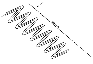
Fig. 3.
False-bedding on a large scale may be a cause of error. In the Penrith Sandstone of Cumberland, the planes of deposition are often found dipping in one direction in a large quarry, but inspection of a wider area shows that this is not the true dip of the beds as a whole, but merely a local dip due to deposition on a slope, and any one attempting to calculate the total thickness of the beds by reference to these divisional planes might be seriously led astray. A reference to Fig. 4 will explain this. The lines AA´, BB´ are the true bedding-planes cut across in the section, whilst the lines sloping to the right from xx are only lines of false-bedding on a large scale. An exaggerated estimate of the thickness of the deposit would be made by measuring the thickness of each of these stratula from A to A´ and adding these thicknesses together, whereas the actual thickness of the middle bed is the distance between A and B or A´ and B´.
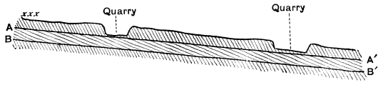
Fig. 4.
When rocks have been affected by thrust-planes, the simulation of bedding may be carried out to a very full extent. Not only do the major thrust-planes resemble bedding-planes but the minor thrusts produce an appearance of divisional planes separating stratula or laminæ, and a close approximation to false-bedding is the result. To this structure Prof. Bonney has given the name 'pseudo-stromatism[17].' It may be developed in rocks of all kinds, whether possessing original planes of stratification or not, and as a result of its existence the geologist may be seriously misled, not merely by mistaking the direction of the strata, but also the nature of the rock, for we may find it produced in an unstratified glacial till, and in a massive igneous rock, and in each case the resulting rock will resemble a sedimentary deposit, and of course the observer may be confirmed in his erroneous opinion by the formation of apparent fossils, ripple-marks or other objects which he might expect to discover in sediments. As illustrative examples, reference may be made to a number of schistose rocks, in which the planes of discontinuity (which are in truth planes of foliation) have been taken for bedding-planes and the rocks claimed as sedimentary though they are in reality igneous; for instance many of the rocks of the Laurentian of Canada, of the Hebridean of the North West Highlands, and some of the ancient rocks of Anglesey.
A foliated structure may, as is now well known, be simulated by a structure developed in a rock prior to its consolidation. The similarity of flow structure of some lavas to the foliated structure of a schist was long ago pointed out by Darwin and Scrope, and recent work has proved that parallel structure due to differential movement prior to consolidation may be developed in plutonic rocks, as shown by Lieut.-General McMahon in the Himalayan granites, and by Lawson amongst the plutonic rocks of the Rainy Lake Region; and as the foliated structure may be mistaken for original stratification the same may occur, and has occurred, when dealing with this flow-structure.
This is not the place to discuss the truth of the old theory of progressive metamorphism, in which it was maintained that a gradual passage could be traced between ordinary sediments and plutonic rocks, but it may be pointed out that much of the evidence which was relied upon to prove the theory was fallacious and due to the confusion of the parallel structure set up in plutonic rocks prior to, or subsequent to, consolidation, with original stratification. Recent study of metamorphic rocks has proved that the parallel structures developed in the rocks of an area which has undergone metamorphism may be produced by three distinct processes; they may be original planes of deposition, or formed in a solid rock subsequently to its formation, or in an igneous rock before its consolidation, and although it is sometimes possible to separate the structures produced by these processes, this is not always the case[18]. When a plutonic rock contains large phenocrysts and an eye-structure is developed in it, it may simulate a conglomerate, the rounded phenocrysts being taken for pebbles[19]. Still closer simulation of an epiclastic conglomerate may be produced in other ways and will be referred to immediately.
We have already seen that the existence of unconformities has been utilised in the demarcation of large divisions of strata in various regions, and whether they be utilised in this manner or not, their detection is a matter of importance to the stratigraphical geologist, as they afford information concerning the occurrence of great physical changes during their production. These unconformities may also be closely simulated by structures produced in very different manner.
The occurrence of an unconformity implies the denudation of one set of beds before the deposition of another set upon them, and accordingly the denuded edges of the lower set will somewhere abut against the lower surface of the lowest deposit or deposits of the overlying set[20]. The existence of an unconformity may often be detected in section, but when the unconformity is upon a large scale this may not be possible, but it will be discovered by mapping the strata and will be apparent on a map owing to the deposits of the lower set of beds abutting against the others. This is well seen where the Permian rocks of Durham, Yorkshire, and Nottinghamshire rest upon different members of the underlying Carboniferous series, and will be noticed on any good geological map of England. But a similar effect may be caused by a fault, so that mere inspection of a map or even of the strata in the field and discovery of one set of beds ending off against another does not prove unconformity. When the fault is a normal one, with low hade (that is, having a fissure approaching the vertical position), the outcrop of the fault-fissure will approximate to a straight line if the fault has a straight course, even if the ground be very uneven, whereas, if the plane of unconformity has not been tilted to a high angle from its original horizontal position, it will crop out in a sinuous manner across uneven ground, in a way similar to that of beds which are nearly horizontal, so that though the general trend of the outcrop of the plane of unconformity may be fairly straight, its deviation from a straight line will be frequent and marked, as seen in the case of the Permian unconformity above referred to. But if the unconformable junction has been highly inclined its outcrop will resemble that of a normal fault, or if the fault be a thrust-plane with high hade, the outcrop of this will resemble that of an unconformable junction which has not been greatly tilted from its original horizontal position. In these cases we require more evidence before we can decide whether we are dealing with an unconformable junction or a faulted one.
The lowest deposits of the newer set of strata lying above an unconformity have probably been laid down in water near the shore-line. As the unconformity, if large, implies elevation above the sea-level, the deposits first formed after this elevation has ceased, and depression commenced, will necessarily be littoral in character and possibly of beach-formation, and accordingly we often find that an unconformity is marked by the existence of an epiclastic conglomerate immediately above the plane of unconformity and, although this need not be continuous, it is usually found somewhere along the line of junction. The conglomeratic base of the Lowest Carboniferous strata when they repose upon the upturned edges of the Lower Palæozoic rocks of the dales of West Yorkshire is well known, and may be cited as an example. The association of conglomerates with unconformities is indeed so frequent that its possible occurrence will always be suspected and sought by the geologist. Unfortunately the result of recent observation is to show that along thrust-planes of which the outcrop simulates those of unconformable junctions, the difficulty of discrimination may be increased by the existence of cataclastic rocks which bear a close resemblance to epiclastic conglomerates, and which may be and have been styled conglomerates. It is well known that fragments of the adjoining rocks are knocked into a fault-fissure during the occurrence of the movements which cause the fault, to constitute a fault-breccia, and as the result of the abrasion of these fragments by chemical or mechanical agency, the angular fragments may become rounded and converted into rounded pebble-like bodies, when the rock is changed into a fault-conglomerate. Fig. 5, from a photograph kindly supplied by Prof. W. W. Watts, shows a stage in the formation of a conglomerate of this nature from a fault-breccia; the fragment on the right remains angular, whilst those on the left have become much more rounded. The illustration is from a case described by Mr Lamplugh occurring in the slaty rocks of the Isle of Man, and Mr Lamplugh's paper[21] furnishes the reader with references to other examples of the production of similar rocks. No general rule can be laid down for distinguishing the true from the apparent unconformity, for the attendant phenomena will differ in each case; but if a fault-conglomerate should be suspected, the observer should try to ascertain whether fragments of a newer rock are imbedded in an older one, which sometimes occurs; he should note the existence of extensive slickensiding along the plane of junction and along planes of faulting, though the existence of these, implying as it does the occurrence of differential movement along the plane, does not prove that the movement was necessarily great, or that it did not take place along a plane of original unconformity; above all, he should look for structures such as mylonitic structure, pseudo-stromatism, development of new minerals, crushing out and stretching of fossils and fragments and, in short, for any structure which is familiar to him as a result of orogenic movements.
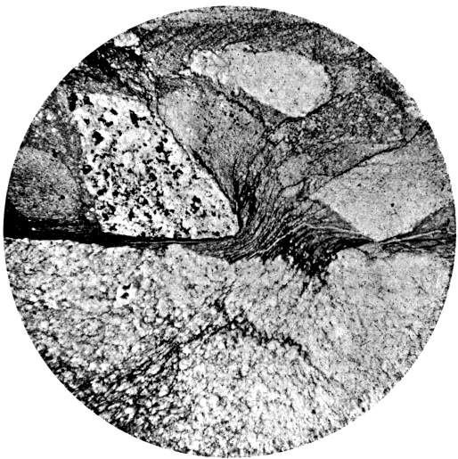
Fig. 5.
The effects of thrusting not only give rise to appearances suggestive of unconformity, but naturally also to a simulation of overlap. The thrust-planes are often parallel to original bedding-planes for some distance, but must cut across them sooner or later, producing lenticular masses which might be supposed to be due to the thinning out of beds as the result of cessation of deposition in a lateral direction.
Attention has already been directed to the deceptive appearance of great thickness of strata which is due to repetition of one stratum or set of strata by a series of thrust-planes, so that there is no actual inversion of any part of a bed. When masses of limestone are affected in this way, the thrust-planes may become sealed up, as the result of chemical change, and a compact irregular mass of limestone devoid of any definite divisional planes may be the consequence, and beds of grit sometimes exhibit the same feature to some extent.
Enough has been said to show that simulation of one structure by another has frequently occurred in rocks in so marked a degree as to render mistakes easy; and that these examples of 'mimicry' in the inorganic world are particularly frequent in rocks which have been subjected to great orogenic movements. The student will do well to acquaint himself with the macroscopic and microscopic structures which may be taken as characteristic of the rocks which have been thus affected, some of which can usually be detected with ease, and when he discovers them he may suspect that many phenomena which appear explicable in one way were in reality produced in a different one, for it is frequently very true of a region in which the rocks have been violently squeezed, stretched and broken that 'things are not what they seem.'
CHAPTER VIII.
GEOLOGICAL MAPS AND SECTIONS.
The writer does not propose to give an account of the intricacies of geological mapping, for their right consideration requires a separate treatise[22]; all he desires is to call attention to some of the uses of geological maps as a means of conveying information. A geological map may be looked upon as an attempt to express as far as possible in two dimensions phenomena which possess three dimensions; this can be done to some extent on the actual surface of the map, by conventional signs, still more fully, by supplementing the map with sections; but best of all by a geological model, which is cut across in various directions in order to show the underground structure as well as that of the surface.
The ordinary geological map is one which shows the outcrop of the strata, subdivided according to age, as they would be seen upon the surface of the earth after stripping off the superficial accumulations, and it is to be feared that the term 'geological map' is associated in the minds of most students with a map of this character and of no other. Nevertheless, a great many most important observations other than those connected with the order of succession of the strata are capable of representation upon a geological map, and the possession of a large number of maps of any area upon the geology of which a person is engaged—each map to be used for recording observations of a particular kind—will save much writing in note-books and, what is of more importance, will allow him to compare observations which have been made at different times at a glance, instead of causing him to search through a series of note-books. Still, however well furnished with maps, the geologist will find a note-book essential[23].
The earliest geological maps represented the variations in the surface soils, or at most the general lithological characters of the rocks which by their decay furnished the materials for the soils. We have seen that the first chronological map was due to William Smith, and most subsequent English geological maps have been based upon his map of the strata of England and Wales. The order of succession of the strata is represented in these maps to some extent by the use of arrows to indicate the direction of dip of the strata, though this is not an unerring guide where strata are reversed, and accordingly the addition of a legend at the side of the map may be looked upon as essential to the correct understanding of the map itself. The legend is usually in the form of a section of a column, the strata being arranged in right order, the oldest at the base and the newest at the summit, the colours by which the strata are indicated being similar to those placed upon the map. Other information besides the mere order of succession of the strata may appear in the legend; thus their relative and actual thicknesses can be indicated if the column is drawn to some definite scale, and a brief description of the lithological characters of the rocks may well be appended to the side of the column. On the actual maps it is customary to exhibit the outcrop of the junctions of all igneous rocks as well as of the sedimentary ones: the nature of the metamorphism which sedimentary rocks have undergone at the contact with igneous ones may be and often is indicated by suitable signs; the position of faults is shown, and often also that of metalliferous veins, the nature of the ore in the latter being further indicated in some suitable manner, as by giving the recognised symbol for the metal; and in many maps an attempt is made to show the variations in dip and strike of the cleavage-planes.
The Geological Survey of the United Kingdom publishes two sets of maps, one showing the 'solid geology' and the other the 'superficial geology.' It is easier to understand these terms than to define them, for in Britain there is a sharp line between the two everywhere except near Cromer. The maps showing the superficial geology represent gravels, glacial drifts and other incoherent accumulations of geologically recent origin, which to a greater or less extent mask the strata below which are usually composed of more or less solidified material. The maps showing the solid geology display the outcrops of these strata, though it is usual to insert alluvium upon these maps, as it is often impossible to trace the junction-lines of the strata below it. Attention has already been directed to the fact that these maps of solid geology, though chronological, that is, having the strata represented according to age, are founded largely upon lithological differences, rather than upon included organisms; and it has been stated that for theoretical purposes two sets of chronological maps, one founded upon lithological differences, the other upon difference of fossil organisms, would be extremely valuable.
Other phenomena are often best represented upon separate maps, for if all observations are crowded upon one map the result will be very confusing. Special glacial maps showing the contour of the country, with the portions between the contour lines coloured differently according to altitude, say the country between sea-level and 500 feet light green, that between 500 and 1000 dark green, that between 1000 and 1500 light brown and so on, exhibiting the direction of all observed glacial striae, the distribution of boulders so far as it is possible, and any other glacial phenomena which can be noted upon the map, will be valuable to the student of glaciation[24].
Various structural features may be well displayed on separate maps. The trend of the axes of folds will be useful, and may be accompanied by other information of cognate character[25]; maps of the distribution of joint planes may be given in combination with those showing the folding of the strata if it be desired to exhibit the relationship between these; or with the physical features of the country, if the dependence of physical features upon joint structure be under consideration[26]. Much information concerning cleavage may be acquired from a map showing anticlinal and synclinal axes of cleavage[27], or the actual strike of the cleavage over different parts of a map may be represented, and its relationship to the geological structure of the district exhibited[28].
Maps exhibiting changes in physical geography appertain to the geologist as well as to the geographer. The position of ancient beaches, former lakes, representation of the changes in the courses of rivers and kindred phenomena may be shown upon maps, and will prove useful[29].
A perusal of the maps to which reference has been made above will give the student some notion of the extent to which maps may be utilised to represent geological structures, and may suggest other methods by which they may be utilised.
A geological section is usually drawn in order to exhibit the lie of the rocks, as it would be seen if a vertical cutting were made in that part of the earth's crust which is under consideration. The character of the section will depend upon circumstances. The Geological Survey of Great Britain issues two kinds of sections which are usually spoken of as vertical sections and horizontal sections, though each is in truth a vertical section; but whereas in the former the horizontal distance represented is small as compared with the thickness of the strata, in the latter the rocks of a considerable horizontal extent of country are exhibited in the section, and the section is not carried down to a great depth below the earth's surface. There is no essential difference between the two kinds of section, and often sections are drawn which cannot be definitely classed as belonging to either kind, but in extreme cases the vertical section is a representation of the order of succession as it would appear if the rocks were horizontal, no matter how disturbed they may be in reality; whereas the horizontal section represents the strata as they actually occur, with all the folds and faults by which they are affected. The accompanying figure (Fig. 6) represents a horizontal section on the left side of the figure with a vertical section of the same rocks on the right side.
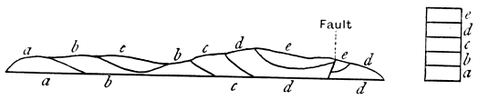
Fig. 6.
Vertical sections are extremely useful when it is desirable to compare variations in the strata over wide extents of country: this can be done by drawing a series of columns of the strata, each showing in vertical section the lithological characters and thicknesses of the strata in one place, whilst the relationship between the strata of two different places may be indicated by joining the beds of the same age by dotted lines as shown in Fig. 7[30].
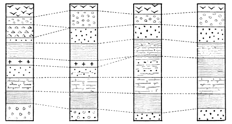
Fig. 7.
The horizontal section is one which is in constant use by the practical geologist: the results of the first traverse of a district may be jotted down in his note-book in the form of a horizontal section (with accompanying notes), and the written memoir on the geology of any district composed largely of stratified rocks will almost certainly require illustration by means of these sections. Perhaps nothing more clearly marks the careful observer than the nature of the sections which he makes, and geological literature is too frequently marred by the publication of slovenly sections. A badly drawn section not only offends the eye, it may and frequently does convey inaccurate information.
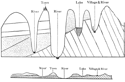
Fig. 8.
In the above figure (Fig. 8) taken from Sir Henry de la Beche's "Sections and Views Illustrative of Geological Phænomena," Plate II., the lower drawing represents a section drawn to true scale, while that above shows one which is exaggerated. The student who saw this would infer that the uppermost beds on the left side of the upper section rested unconformably upon the dotted beds beneath, and once abutted against them in that portion of the figure where the beds have been removed by denudation in the deep valley, whereas an examination of the section drawn to true scale shows that the unconformity does not exist (although there is one at the base of the deposits marked by dots), and that there is room for the higher deposits to pass above those marked by dots at the place where the former have been removed by denudation. Whenever possible, horizontal sections should be drawn to true scale, the vertical heights being on the same scale as the horizontal distances. Sections which are so drawn represent the nature of the surface of the country as well as the relationship of the strata, and often illustrate in a marked degree the influence which the character of the strata has exerted upon the nature of the superficial features of a country. If it be impossible to draw a section in which the elevations and horizontal distances are represented upon a true scale, the former ought to be drawn on a scale which is a multiple of the latter; thus the vertical heights may be shown on 2, 3, or 4 or more times the scale chosen for the horizontal distances; when this is done, it will often be necessary to show the strata with an exaggerated dip, and accordingly the exaggerated section loses some of its value, though if vertical and horizontal scales bear some definite proportion it will still be more valuable than a rough diagram which is not drawn to any scale.
Section-drawing cannot be satisfactorily accomplished without some practice, and the student is strongly advised to acquire the art of drawing good sections; the writer can assert as the result of considerable experience in the conduct of examinations of all kinds, that slovenly sections are the rule in candidates' papers, and good sections very rarely appear. Study of the six-inch maps and horizontal sections (drawn on the same scale) of the Geological Survey of the United Kingdom will enable the student to familiarise himself with admirable sections, and it should be his aim to produce sections like these. He is recommended to take some of these six-inch maps which show contour-lines as well as the disposition of the strata, and to draw sections on the scale of six inches to the mile, vertical and horizontal, exhibiting the proper outline of the ground and the arrangement of the strata, and afterwards to compare them with the published sections. The sections should be drawn as far as possible at right angles to the general strike of the strata. Some datum-line is taken for the base of the section (say sea-level) and offsets drawn vertically from this where the section crosses a contour-line or recorded height. The height is marked on these offsets; thus if a recorded height of 2700 feet (just over half a mile) occurred on the line of section a height of somewhat over three inches is marked on the offset, and so with the other points where the section crosses contours or recorded heights. By joining these points on the offsets, giving the connecting lines curves similar to those which are likely to occur in nature, the general character of the surface of the ground is represented. The geology of the district is next shown. Wherever a dip is marked on the map, the direction and amount of dip is shown by a short line on the section, and where dips are not actually seen along the line of section, the dips which are nearest to that line on the map must be considered, and marked on the section. The lines of junction between the various deposits shown by different colours upon the map are inserted on the section as short lines, the inclination being judged by study of the nearest dips; faults and igneous rocks must be marked off, and any indication of the hade of the fault or the slope of the edges of the igneous rock which the map affords will be taken into account. The section will then appear somewhat as shown in the following figure:

Fig. 9.
and sufficient indication of the trend of the rocks will be obtained to shew that they form portions of curves which may then be filled in as shown in Fig. 10 and the section will be complete.

Fig. 10.
It will be noticed that the small dyke of igneous rock on the right of the main dyke is joined to it lower down, though no indication of this is given along the line of section; but the requisite information for this and evidence of the existence of the small dyke proceeding from the left-hand side of the main one may be obtained by the study of the rocks in a valley on one side or other of the line of section.
After the student has become conversant with the nature of geological maps and sections, and has read Sir A. Geikie's Outlines of Field Geology, he should on no account omit to learn something of the art of making geological maps, by going into the field and attempting to produce a map, for the art of geological surveying does not come naturally to any one, and some acquaintance with the methods of surveying is a necessity to everyone who wishes to make original geological observations, though all cannot expect to afford the time and acquire the skill necessary for the production of maps vying with the detailed maps of the Government Survey. Before actually attempting to draw lines on a map on his own account, he will do well to tramp over a portion of a district with the published geological map in his hands, selecting a country which is not characterised by great intricacy of geological structure, and he can then attempt to represent the geology of another portion of the same district without consulting the published map. Of all the districts of Britain with which he is acquainted the writer believes that the basin of the river Ribble, in the neighbourhood of the town of Settle in the West Riding of Yorkshire, is best adapted for studying field geology in the way suggested above, for the main geological features are marked by extreme simplicity, and the exposures are good, whilst the presence of an important fault-system and of a great unconformity relieve the area from monotony. Anyone who stands on the summit of Ingleborough or Penyghent will grasp the main features of a portion of the district without any difficulty, for it lies beneath his feet like a geological model, and when the student has mastered and mapped in the leading features, he can find bits of country with geology of varying degrees of complexity amongst the Lower Palæozoic rocks of the valleys which run down to Ingleton, Clapham, Austwick and Settle.
The biologist is supplied with laboratories at home and abroad, where he may study his science under the best conditions. Would that some munificent person would found, in a district like that referred to above, a geological station where Cambridge students would have the means of acquiring a knowledge of field-geology under conditions more favourable than those presented by the flats around the sluggish Cam!
CHAPTER IX.
EVIDENCES OF CONDITIONS UNDER WHICH STRATA WERE FORMED.
The establishment of the order of succession of the strata, and the correlation of strata of different areas merely pave the way for the geologist. To write the history of the earth during various geological ages, he has to ascertain the physical and climatic conditions which prevailed during the successive geological periods, and to study the various problems connected with the life of each period. In the present chapter an attempt will be made to illustrate the methods which have been pursued in order to write to the fullest degree which is compatible with our present knowledge, the earth-history of various ages of the past. In making this attempt, the physical and climatic conditions may be first considered, and their consideration followed by that of the changes in the faunas, though it will frequently be necessary to refer to one set of conditions as illustrative of the other.
It will be assumed here that the great principle of geology, that the modern changes of the earth and its inhabitants are illustrative of past changes, is rigidly true. Reference will be made to this principle in a later chapter, but it is sufficient to state here that the study of the sediments which have been deposited from the commencement of Lower Palæozoic times to the times in which we now live bear the marks of having been formed under physical conditions, which, in the main, are similar in kind to those which prevail upon some part of the surface of the lithosphere at the present day.
One of the most important inferences of the stratigrapher relates to the existence of marine or terrestrial conditions over an area at any particular time, and we may, in the first place, consider the evidence which supplies us with a clue to this subject.
It has been previously stated that the ocean is essentially the theatre of deposition, the land that of destruction, and accordingly, the presence of deposit as a general rule indicates the evidence of marine conditions during the formation of those deposits, though this is not universally the case. Again, as denudation is practically confined to the land areas, and the shallow-waters at their margins, unconformity on a large scale gives evidence of the existence of terrestrial conditions in the area in which it is developed, during its production. Accordingly a mass of deposit separated from deposits above and below by marked unconformities shows the alternation of terrestrial conditions (during which the unconformity was produced) and marine conditions (during which the deposits were laid down). The deposits formed after an unconformity has been developed will naturally be of shallow-water character, as will also be those of the period immediately preceding the incoming of conditions which will cause the occurrence of another unconformity, and between these two shallow-water periods will occur a period when deeper-water conditions probably prevailed. We can therefore not only divide the history of any particular area into a series of chapters, of which every two successive ones will describe a continental period and a marine one, but each marine period may be divided into three phases—a shallow-water phase at the commencement, an intermediate deeper-water phase, and a shallow-water phase at the end. These phases are frequently complicated by the occurrence of a host of minor changes, but on eliminating these, the effects of the three great phases are shown by study of the nature of the strata, and their recognition does much to simplify the detailed study of the stratigraphical geology of various parts of the earth's surface.
In discriminating between terrestrial conditions and marine ones, the existence of unconformities is of great importance in marking terrestrial conditions and is often the only available evidence, for no accumulations or deposits formed on the land may be preserved to testify to the terrestrial conditions[31]. When terrestrial deposits and accumulations do occur, they are extremely important, and it is necessary to allude to the points wherein they differ from marine deposits.
Apart from organic contents, the mechanically formed deposits of rivers and lakes resemble in general characters the shallow-water deposits of the ocean, though they are usually less widely distributed. It is the accumulations which have actually been formed as æolian rocks, or those which have been laid down as chemical precipitates in salt-lakes which, by study of lithological characters, furnish the most convincing evidence of their terrestrial origin.
Many æolian accumulations may be looked upon as soils, if the term soil be used in a special sense to refer to the accumulations which are produced as the result of the excess of disintegration over transportation in an area, whilst others are due to transport which has not been sufficiently effective to carry the material to the sea. When the weathered material accumulates above the weathered rock, it depends chiefly upon climate whether the disintegrated rock becomes mingled with much decayed organic matter forming humus. If this organic matter exists in quantity, the probability is that the accumulation is a terrestrial one, though this is by no means necessarily the case, for under exceptional circumstances a good deal of humus may be deposited in the sea, as beneath the mangrove-swamps which line the coasts of some regions, and to go further back, in the case of the Cromer Forest series of Pliocene times, or some coals, such as the Wigan Cannel Coal of the Carboniferous strata.
In addition to the work of water, which affects both land and sea-deposits, the land is especially characterised by the operations of wind and frost upon it, for these produce results which may frequently serve to differentiate a land-accumulation from a deposit laid down beneath sea-level. The effect of wind in rounding the grains of sand which are blown by it is well-known, and samples of the 'millet-seed' sands of desert regions are preserved in most museums. The greater rounding which characterises wind-borne as compared with water-borne sand grains is due, in great measure, to the greater friction between the grains when carried by the air than when swept along by the water. Under favourable circumstances water-worn grains may become rounded, especially when agitated by gentle currents sweeping over a shoal[32]; but a large mass of sand, in which most of the grains have undergone much rounding so as to give rise to 'millet-seed' sand, will nevertheless be probably formed by wind-action except where a marine deposit is formed of material largely derived from an earlier æolian one. The effect of frost is to split rocks into fragments which are more or less angular before they are subjected to water-action. The broken fragments are prone to collect on slopes as screes, and as any scree-material falling into the sea is likely to become rounded except under conditions which rarely prevail, the existence of much scree-material in a rock suggests its terrestrial origin. Glaciers gave rise to terrestrial moraines, which may occasionally be identified as land-accumulations by mere inspection of their physical characters, but all geologists are aware of the difficulties with which they are confronted when they attempt to discriminate between terrestrial and marine glacial deposits.
The existence of much material amongst the stratified rocks which has been precipitated from a state of solution is an indication of the terrestrial origin of the rocks, which were laid down on the floors of the inland seas, separated more or less completely from the open ocean; for the waters of the ocean are capable of retaining in solution all of the material which is brought down to them, and accordingly precipitates of carbonate of lime, rock-salt, gypsum and other compounds formed from solution, are only formed on a large scale in inland lakes, though they may be formed to some extent when the water of a lagoon is only slightly connected with that of the open ocean, and the evaporation is great, for instance in the lagoons of coral reefs. Certain physical features often mark the deposits of chemical origin, cubical or hopper-crystals of rock-salt may be dissolved, and the hollow afterwards filled with mud, so that the rock surfaces are sometimes marked with pseudomorphs of mud after rock-salt. Sun-cracks and rain-prints impressed on the rock are not actual indications of terrestrial origin of the rocks on which they are found, for the shallow-water muds of an estuary may be deposited in the sea and yet exposed to the action of the air at low tide, but they mark very shallow-water deposits which have been exposed to the atmosphere immediately after their formation if not during the time they were formed, and they frequently occur amongst the deposits of inland lakes.
It will be observed that the characters of the terrestrial accumulations serve to distinguish them to some extent from the marine ones, but they also enable one to detect to some degree the actual conditions under which the accumulation was produced, whether on the mountain-slope, or in the plain, the desert or the fen, the river-bank or the lake-floor.
The conditions of formation of the marine deposits may be distinguished within certain limits with ease, by examination of their physical characters, for the near-shore deposits will generally be coarser and contain more mechanically-transported material than the sediments which accumulate at a greater distance from the shore, though it is not safe to infer that deposits are formed away from the shore on account of the absence of mechanically-transported sediments. In districts where the mechanically-transported material is rapidly deposited, organic deposits of great purity may form close to the coast-line; for instance, when the rivers of a country end in fjords, the mechanical sediments are deposited in the fjords, and the sea around the coast is free from this sediment, and there the organisms can build up deposits of great purity; and a similar thing may happen when the rivers on one side of a country have short courses, and do not carry down much sediment, which occurs when the watershed is near the coast. On the one hand, clay may be formed in considerable purity near the coast, where the supply of mud is so great that the organisms existing there can do little in the way of contribution to the mass of the deposit, or it may be formed on the other hand in great depths of the ocean, where the supply of sediment is extremely small, but where all the organic tests become dissolved; as the characters of the deep sea clays are mainly negative, a geologist examining the rocks of the geological column would have much difficulty in distinguishing a deep-water clay from a shallow-water one by its lithological characters only. In cases of difficulty, information of importance is likely to be furnished by examination of the relative thickness of equivalent deposits in adjoining areas, for if we find a mass of clay a few feet thick in one region represented by hundreds of feet of clay and limestone in another, the former mass probably accumulated slowly and at some distance from the land; again, the uniformity of lithological characters of a deposit over a very wide area is a possible indication of its formation away from land, but this is not a safe guide, for reasons which will eventually appear, unless it can be shown that the deposit is everywhere of the same age.
A clue to climatic conditions is frequently furnished by the physical characters of accumulations, especially terrestrial ones. The accumulations containing a large percentage of hydrocarbons have probably been formed under fairly temperate and moist climatic conditions, whilst the existence of millet-seed sandstones associated with chemical deposits points to desert conditions and inland lakes, requiring a dry climate and probably a warm one. Glaciated surfaces and glacial deposits of course indicate a low temperature. Some geologists profess that occasionally they can even determine the direction of the prevailing winds during past periods, by examination of the character of ripple-marks, rain-pits and other features, though it is doubtful whether much reliance can be placed upon these obscure indications.
Useful as is the physical evidence supplied by deposits, as an index to the conditions under which they were formed, it is usually only supplementary to the evidence derived from a study of the fossils. Fossils when present in the rocks, usually supply considerable information concerning the prevalent conditions during the deposition of the rocks. By them we can not only separate marine from terrestrial deposits, but also freshwater deposits from æolian accumulations; each kind of deposit will generally contain the remains of organisms which existed under the conditions prevalent in the area of formation of the rock, though it is of course a frequent thing for a terrestrial creature or plant to be washed into a freshwater area or into the sea. In an æolian deposit, the invertebrate remains may be those of any air-breathing forms, as insects, galley-worms, spiders, scorpions and molluscs. The land-molluscs are all univalve. Of vertebrates, we may find the bones and teeth of amphibians, reptiles, birds and mammals. Occasionally freshwater or even marine forms may be found in an æolian deposit, but they will be exceptional. Marine shells are often blown amongst the sand-grains of the coastal dunes, and seagulls and other birds frequently carry marine organisms far inland.
The creatures frequenting fresh water differ from those of the land and of the sea. The most abundant vertebrate remains will be those of fishes, and of the invertebrates we find mollusca preponderate. The variety of molluscs is not so great as in the case of marine faunas. The bivalves always possess two muscular scars on each valve (except adult Mulleria); whilst many marine shells as the oyster have only one muscular scar on each valve. (See Fig. 11.)
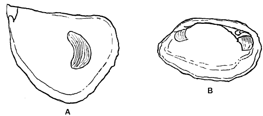
Fig. 11. A. Monomyary shell with one scar. B. Dimyary shell with two scars.
These scars mark the attachment of the adductor muscles, for drawing the valves together, and the shells with only one impression on each valve are called monomyary, those with two impressions dimyary. The discovery of monomyary shells indicates with tolerable certainty the marine character of the deposit in which they are found, though their absence cannot be taken as proof of freshwater origin. The beaks or umbones of the bivalves are often corroded in freshwater deposits, as may be seen by examining shells of the common freshwater mussel. "All univalve shells of land and freshwater species, with the exception of Melanopsis and Achatina, which has a slight indentation, have entire mouths; and this circumstance may often serve as a convenient rule for distinguishing freshwater from marine strata; since if any univalves occur of which the mouths are not entire, we may presume that the formation is marine[33]."
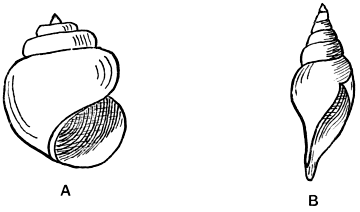
Fig. 12. A. Holostomatous shell. B. Siphonostomatous shell.
In Fig. 12 A shows a freshwater shell (Vivipara) with entire mouth, whilst B exhibits the shell of a marine gastropod (Pleurotoma) with a notched mouth. The entire-mouthed shells are called holostomatous whilst those which are notched, the notch being often prolonged into a canal, are termed siphonostomatous.
Many groups of invertebrates are seldom or never found in fresh water. Of exclusively or nearly exclusively marine creatures we may name the foraminifera, radiolaria, sponges with a hard framework, most hydrozoa which secrete hard parts, corals, echinoderms, cirripedes, king-crabs, locust-shrimps, most polyzoa, brachiopods, pteropods, heteropods, and cephalopods. Of extinct groups, the graptolites and trilobites seem to have been entirely confined to the sea.
In the modern and comparatively modern deposits, the forms frequently belong to existing genera, and we get fairly conclusive evidence of the conditions of deposit by determination of the genera. The terrestrial (including freshwater) molluscs have mostly a long range in time. We find pulmoniferous gastropods of living genera in the Carboniferous period, one (Dendropupa) belongs to a subgenus of the modern land-shell Pupa, the other (Zonites) to a subgenus of the snail group Helix. Many freshwater molluscs as Unio, Cyclas, and Physa are found amongst the secondary rocks, and give a clue to the origin of the deposits which contain them. Many extinct genera are closely allied to modern genera, and their mode of existence may be assumed with fair certainty. With all these guides, we may sometimes be left in doubt as to the conditions of deposit when organisms are few in number; thus, it is yet a matter for discussion whether the Old Red Sandstone and many of the deposits of the Coal Measures of Britain were of freshwater or marine origin.
In considering the possibility of fossils having been carried from land to water or vice versa, it will be remembered that generally speaking they are more readily transferred from a higher to a lower level, so we are more likely to find remains of land-animals and plants in fresh water or the sea, and relics of freshwater animals and plants in the sea, than of marine or freshwater animals and plants in land, or marine organisms in fresh water. River-gravels and lacustrine deposits are especially prone to contain a considerable intermixture of land-forms with those proper to the station.
Fossils supply much information concerning the depth and distance from land at which the deposits were laid down. When portions of the ocean-water have been separated to form inland lakes, the water becomes saltier than that of the open ocean, if the evaporation is greater than the supply of fresh water, and the life of the inland sea undergoes change under the unfavourable conditions set up. Many forms disappear altogether, and those which survive tend to become stunted, and the shells of many of the mollusca are abnormally thin; the fauna of an inland sea though it may have abundance of individuals is apt to be characterised by paucity of species.
Turning now to the faunas of the open oceans, it is found that in addition to latitude, the distribution of organisms is affected by depth, and by the nature of the sea-floor, and accordingly we find different organisms in different areas; and in examining the same area the organisms inhabiting different depths are not all the same, and at the same depth some kinds of animals have different stations from those of others, one creature being confined to a sandy floor, another to a muddy one, and so on[34]. The oceans have been divided into 18 provinces, each of which is more or less characterised by the possession of peculiar forms which are termed endemic, in contrast to the sporadic forms which are widely distributed. In any area which is margined by a coast line, the molluscs are distributed in zones which were formerly classed as follows:—the littoral zone between tide marks, the laminarian zone from low water to fifteen fathoms, the coralline zone between fifteen and fifty fathoms, and the deep-sea coral zone from fifty fathoms to one hundred fathoms or more; this last depth was once supposed to mark the limit of the downward extension of marine life, but as the result of modern deep-sea soundings we know that organisms extend to a much greater depth, and the deep-sea fauna, owing to uniformity of conditions over wide areas, contains fewer endemic forms in proportion to the sporadic ones than the shallow-water[35]. The deep-sea deposits entomb the remains of these deep-sea organisms and also of numerous pelagic organisms which live upon the surface of the ocean, whose remains sink to the ocean-floor after death. Amongst the deposits of the deeper parts of the ocean, we find many which are almost exclusively composed of the tests of foraminifera, radiolaria and pteropods, the spicules of sponges, and the frustules of diatoms; and accordingly the existence of foraminiferal, pteropodan, radiolarian, and diatomaceous oozes, amongst the strata of the geological column, has been taken by some as indicating the prevalence of deep-sea conditions during the formation of those deposits: as the purity of a calcareous ooze depends upon the absence of mechanical sediment, or volcanic dust, and as the component organisms of these oozes are pelagic forms which live near the continents as well as in the open oceans, the presence of calcareous oozes implies the existence of a clear sea during their deposition but not necessarily of a deep one, for if the sea-area be far away from land masses, or if the sediment be strained off in fjords, calcareous oozes may be formed in shallow water. The existence of pure radiolarian or diatomaceous deposits is better evidence of deep water, for if they were formed in shallow water we should expect an intermixture of calcareous tests, whereas these are dissolved whilst sinking into the extreme depths of the ocean. As the deep-sea creatures are under very different conditions from those of shallower waters, we might expect marked structural differences between the deep and shallow-water creatures: one such difference has been emphasized, namely the occurrence of animals which are blind or have enormously developed eyes in the great depths of the sea, where the only light is due to phosphorescent organisms. This is well seen in the case of many recent crustacea, and has been noted by Suess in the case of the trilobites of some beds which he accordingly infers to be of deep-water origin, and it is interesting to find that these creatures are found in deposits which give independent evidence of an open-water origin. The Æglinæ of the Ordovician strata are frequently furnished with enormous eyes, and they are often accompanied by blind trilobites, and in Bohemia the blind and large-eyed forms are sometimes different species of the same genus, for instance Illænus[36].
As one would naturally expect, the actual depth at which deposits were formed can generally be calculated with a greater degree of certainty amongst the newer rocks than amongst the older ones. In the case of the Pliocene Crags, the depth in fathoms may be confidently given. In the Cretaceous rocks attempts have been made to give numerical estimates of the depths at which different accumulations were formed, but some differences of opinion have arisen in the case of these rocks. In the Palæozoic rocks, only a rough idea of the general depth can usually be obtained, and no attempt to calculate the depth in fathoms is likely to be even approximately correct in the present state of our knowledge.
The comminution of fossils has sometimes been taken as an indication of shallower water origin of the deposits which contain them, but although the hard parts of organisms in a broken condition have frequently been shattered by the action of the waves, they may also be broken at great depths by predaceous creatures, and in many instances the fracture is the result of earth-movements occurring subsequently to the formation of the deposits.
Turning now to the difference in organisms which results from difference of station, it will be sufficient to give a quotation from Woodward's Manual of the Mollusca as an illustration:—"In Europe the characteristic genera of rocky shores are Littorina, Patella, and Purpura; of sandy beaches, Cardium, Tellina, Solen; gravelly shores, Mytilus; and on muddy shores, Lutraria and Pullastra. On rocky coasts are also found many species of Haliotis, Siphonaria, Fissurella, and Trochus; they occur at various levels, some only at the high-water line, others in a middle zone, or at the verge of low-water. Cypræa and Conus shelter under coral-blocks, and Cerithium, Terebra, Natica and Pyramidella bury in sand at low-water, but may be found by tracing the marks of their long burrows (Macgillivray)[37]."
The geologist will naturally select sporadic forms rather than endemic ones in comparing the strata of different areas, but how far differences in faunas are the result of existence at different times, and how far they are due to difference of conditions affecting contemporaneous organisms can only be discovered as the result of accurate observation. The main points to be regarded when comparing the successive faunas of different regions have been noticed in this and the preceding chapters, and it has been shown that as the evidence is cumulative, it requires the collection of a large number of facts obtained by observation of the strata before accurate inferences can be drawn.
The indications of climatic conditions furnished by organisms require some consideration. In the comparatively recent deposits it is not difficult to get some notion of the prevalent climatic conditions when the fossils belong to forms closely related to modern genera. The existence of the arctic birch and arctic willow, and of shells belonging to species now living north of the British Isles, in deposits of comparatively recent date in Britain would afford convincing evidence of the occurrence of colder climatic conditions than those which are now prevalent in the area, even if the evidence were not confirmed as it is, by physical proof of glaciation in deposits of the same age. Nevertheless, even in these recent beds, we have a useful warning, by finding species of elephant and rhinoceros associated with northern forms like the lemming, glutton, and musk-ox. We know that the species of elephant and rhinoceros (the mammoth and woolly rhinoceros) were provided with thick coverings which would enable them to resist the severity of an arctic climate, but had not these coverings been found, we might have been puzzled by the association of forms whose nearest allies are sub-tropical with others of arctic character. As we go back in time and deal with earlier deposits, the ascertainment of the climatic conditions becomes more difficult, as the fossils mostly belong to extinct species, genera or even families.
In these circumstances, it is very dangerous to draw conclusions as to climatic conditions from examination of a few forms, but when we find that plants and animals, terrestrial and marine forms, vertebrates and invertebrates alike point to the same conclusion, as in the London Clay, where all the fossils belong to forms allied to those now living under sub-tropical conditions, the state of the climate may be inferred with considerable certainty[38]. The character of the fossils must be taken into account rather than their size. There was a tendency amongst geologists to believe that large organisms probably indicate warm conditions. Recent researches in arctic seas have dispelled this belief. Marine algæ of enormous size are found in the cold seas, and the size of creatures, abundance of individuals and variety of forms in the arctic faunas of some regions is very noteworthy. In the Kara Sea, for instance, a variety of creatures were dredged up during the voyage of the Vega, and Baron Nordenskjöld makes the following pertinent remarks about them: "For the science of our time, which so often places the origin of a northern form in the south, and vice versa, as the foundation of very wide theoretical conclusions, a knowledge of the types which can live by turns in nearly fresh water of a temperature of +10°, and in water cooled down to -2·7° and of nearly the same salinity as that of the Mediterranean, must have a certain interest. The most remarkable were, according to Dr Stuxberg, the following: a species of Mysis, Diastylis Rathkei Kr., Idothea entomon Lin., Idothea Sabinei Kr., two species of Lysianassida, Pontoporeia setosa Stbrg., Halimedon brevicalcar Goës, an Annelid, a Molgula, Yoldia intermedia M. Sars, Yoldia (?) arctica Gray, and a Solecurtus[39]. "The temperatures were taken by a centigrade thermometer. Again we read of the results of dredging off Cape Chelyuskin. "The yield of the trawling was extraordinarily abundant; large asterids, crinoids, sponges, holothuria, a gigantic sea-spider (Pycnogonid), masses of worms, crustacea, etc. It was the most abundant yield that the trawl-net at any one time brought up during the whole of our voyage round the coast of Asia, and this from the sea off the northern extremity of that continent[40]."
Amongst the marine invertebrates reef-building corals and mollusca perhaps furnish the best evidence of climatic conditions. The coral-reefs of the Jurassic rocks with large gastropods and lamellibranchs clustered around them have been appealed to in proof of the existence of sub-tropical conditions during their formation; further back in time we find evidence of climate furnished by the fossils of the Silurian rocks of the Isle of Gothland in the Baltic Sea. Of these, Lindström writes "The fauna had a tropical character. In consideration of the great numbers of Pleurotomariae, Trochi, Turbinidae and the large Pteropods the assumption of a tropical character of the fauna may seem justifiable[41]."
Structure may give some indication of climate even though the organism is not allied to living species. The bark of trees in arctic regions is often thicker than in more temperate regions, and the leaves of arctic plants often have special characters to enable them to resist the long periods during which they are deprived of water, though the fact that desert-plants frequently shew similar modifications deprives this test of any particular value except as a means of corroborating conclusions reached from other evidence[42]. The shells of arctic mollusca may become stunted, but this is not by any means universal, and the same result may be brought about by other abnormal conditions, as for instance the increase of salt in a water area by evaporation.
On the whole, an examination of the evidence available for ascertaining the character of climate by reference to included organisms, shews that inferences may be drawn within certain limits, but that the task is a difficult one not unaccompanied by danger, and every kind of available evidence derived from a study of physical phenomena and the included organisms should be utilised before any conclusion is drawn.
The likelihood of accurate inference is increased by comparing the faunas of various areas; should they seem to indicate a progressive lowering of climate when passing from lower to higher latitudes, it is probable that the indication is correct. The student is referred to a paper by the late Professor Neumayr for an account of the existence of climatic zones during the Mesozoic Period[43].
CHAPTER X.
EVIDENCES OF CONDITIONS UNDER WHICH STRATA WERE FORMED, CONTINUED.
In the preceding chapter, attention was drawn to the indications as to conditions of deposition furnished by the sediments of any one locality, and only passing reference was made to variation in the nature of the sediments and their organic contents, when the deposits are traced laterally from place to place; some attention must now be paid to this matter.
It is sometimes inferred that, whereas similarity of organisms is a dangerous guide in correlating the strata of two areas, accurate correlations may be made, if the deposits can be traced continuously through the intervening interval; no doubt the task is simplified when this can be done, but the continuity of deposit of one particular composition is no more proof of contemporaneity than the occurrence of the same fossils continuously through the interval, imbedded in strata of different character, indeed probably not so much so. The existence of widespread masses of conglomerate, which are not found as linear strips, but which extend in all directions, is in itself an indication of this; the Oldhaven pebble bed for instance, in the Tertiary rocks of the London basin, is very widely distributed. We cannot suppose that coastal conditions prevailed far away from the shore-line, and accordingly when a conglomerate occurs in a widespread sheet, and not in a linear strip, this is indicative that the deposit has not been formed continuously but that strip has been added to strip along an advancing or receding shore line, and if this happens with conglomerates, it must occur also in the case of other deposits.
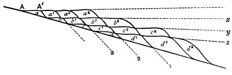
Fig. 13.
In Fig. 13[44] let A represent a shore line of a continent which is undergoing gradual elevation. A deposit of pebbles a will be formed against the coast, one of sand b further away, then one of mud c and lastly limestone d, may be formed in the open sea away from land. Naturally there may be intermingling of two kinds of deposit at the junctions, but for the sake of simplicity this may be disregarded. During the accumulation of the deposits a, b, c, d, certain sporadic forms may be distributed throughout all the deposits, and some of them may become extinct before the deposition of these beds is completed, if the process is carried out on a large scale; we may speak of the characteristic fossils of this period as fauna I. As the result of elevation or of mere silting up of the sea-margin, or of both combined, the next mass of pebble-deposit will be laid down further away from the original shore, for the shore line will now be at A´ and not at A, and it will partly overlap the mass of sand b; the sand b1 will also be deposited somewhat further out and partly overlap the mud c, and similarly the mud c1 will partly overlie the limestone d. During the formation of a1, b1, c1, d1, other sporadic forms belonging to a fauna II may replace those of the first fauna. In the same way a2, b2, c2, d2 will be deposited, and in the meantime a new fauna III may arise and replace II. So the process will go on until we finally have a group of deposits lying one over the other, consisting of a basal accumulation of limestone, succeeded by mud, sandstone and pebble-beds in succession. Each of these will be continuous, though the inner part of the pebble-deposit was formed long before the outer part of the limestone, which is nevertheless beneath a mass of pebble-deposit continuous with that formed first, and the various deposits will be separated by fairly horizontal planes x, y, z, which might be regarded as bedding planes, but which are not so, strictly speaking. The true bedding planes will occur at a slight angle to these planes of separation, for the structure resembles false bedding on a gigantic scale, but of course, the lines separating two masses of similar deposit will be practically horizontal and parallel to the planes of demarcation of two distinct kinds of material. The lines separating two faunas would, under the conditions postulated, run approximately parallel to the planes of separation of adjoining deposits of the same lithological character but would pass from conglomerate, through sandstone, mud and limestone, as indicated by the lines 1, 2, 3, ... and the deposits between adjoining lines would be contemporaneous[45]. In nature, complications will arise, owing to the gradual appearance and disappearance of forms, and the existence of endemic species in contemporaneous deposits formed in different stations and having different lithological characters.
If elevation ceased and were succeeded by depression, the exact opposite would occur, and the pebble beds would be overlain by sandstones, these by muds, and lastly limestones would appear. It follows that during a marine phase occurring between two unconformities we should have a V-shaped accumulation of deposits with the apex pointing to the part of the shore line which was last submerged before the commencement of elevation, as shewn in Fig. 14, though the beds of the apex will in most cases be denuded during the re-emergence.
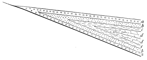
Fig. 14.
Indications of the non-coincidence of the planes separating faunas and those which separate deposits of one lithological character from those of another have already been detected, for instance the 'greensand' condition of the Cretaceous period occurs in some places during the existence of one fauna, and in others during that of another, though the planes have not been traced continuously. Mr Lamplugh has furnished another example amongst the Cretaceous rocks of Yorkshire and Lincolnshire, but as has already been observed, a great deal remains to be done in this direction, and geologists are much in want of two sets of stratigraphical maps, in one of which the lines are drawn with reference to the differences of lithological character, whilst in the other they separate different faunas.
The student will notice the normal recurrence of deposits in definite order; conglomerate succeeded by sandstone, mud and limestone, in a sinking area, and limestone succeeded by mud, sandstone and conglomerate in a rising area. Naturally many instances of departure from this rule are seen, owing to local conditions, but on a large scale, it is very frequently noted, and recognition of this will enable the student to remember the variations in the lithological characters of the deposits more easily, than if he simply acquired them from a text-book without taking heed as to their significance.
Upon the variations in the lithological characters of deposits and of their faunas, when the beds are traced laterally depends very largely the successful ascertainment of the existence of former coast-lines, the restoration of which constitutes an important part, of Palæo-physiography, concerning which some observations may here be made[46]. If a set of deposits having different lithological characters can be proved to be contemporaneous, the coarser detrital accumulations will point to the approach to a coast-line, and the actual position of the coast during the period of accumulation of the deposits may be very accurately fixed. The pebble-beds at the base of the Cambrian rocks of Llanberis indicate the existence of a coast-line in that position during the accumulation of those pebble-beds. Similar pebble-beds occur at St David's, at the base of the Cambrian, but it is impossible in the case of these rapidly accumulated sediments to say that two deposited so far away from one another were actually contemporaneous, and therefore although we might draw a line through Llanberis and St David's to indicate the old coast-line of the period, it does not follow that the actual beach existed simultaneously at the positions indicated. The palæo-physiographer, however, attempts to restore the physical conditions of greater thicknesses of deposit; for instance, the distribution of land and sea during Lower Carboniferous times over the area now occupied by the British Isles is often taken to illustrate the methods of restoration of ancient features, and all admit that the lithological and palæontological characters of the rocks indicate a shallowing of the Carboniferous sea when passing northwards towards Scotland. For conveying an idea of the restorations to the student, it is almost imperative to portray the distribution of land and sea upon a map, and this can only be done by drawing definite lines. It must be distinctly understood that these lines are necessarily only an approximation to the actual position of the ancient shore-lines, which must have shifted again and again during the long period occupied by the accumulation of the Lower Carboniferous strata, so that a true idea of the positions of the Lower Carboniferous shore-lines could only be obtained by placing on a series of maps the successive shore-lines of different parts of the Lower Carboniferous period, and taking a composite photograph of these, which would appear as a wide belt of shaded portion of the map with no definite boundaries. The utmost that the maker of palæo-physiographical maps can expect to indicate, when dealing with considerable thicknesses of strata, is an approximation to the mean position of the shore-lines of the period when these strata were deposited. This is extremely valuable in enabling the student to understand the significance of the variations in the characters of the strata and their organic contents, if he distinctly recognises the generalised nature of the map. Examination of any two palæo-physiographical maps of the same period by different authors will shew wide divergences in the details, but a general resemblance of the main features. The reader will do well to consult Prof. Hull's restoration of the physical features of Old Red Sandstone and Lower Carboniferous Times on Plate VI. of his Contributions to the Physical History of the British Isles, and compare it with the map drawn by Prof. Green (Coal: its History and Uses, by Profs. Green, Miall, Thorpe, Rücker, and Marshall, Fig. 3, p. 38), which will be found to bear out this statement.