ON THE PLEISTOCENE GEOLOGY OF NORTH AMERICA AND ITS RELATION TO ITS FOSSIL VERTEBRATES. (continued 2)
Reading edition
Bears were abundantly present in the cave. One species, Arctotherium haplodon, was larger than the grizzly bear and represented by parts of 314about 25 individuals. A smaller bear, indicated by 8 individuals, appeared to be in no way different from the existing black bear, Ursus americanus. Of skunks there are listed 7 species, belonging to 3 genera, all the species being extinct except a supposed Mephitis putida. Besides these mustelids, there have been identified remains of the existing badger, the existing glutton, an extinct weasel, Mustela diluviana, and an extinct otter, Lutra rhoadsii. Remains of true dogs were not abundant in the collection. Cope recognized, however, 2 species of the genus Canis, one of about the size of the more common form of the existing wolf; the other exceeding in size the largest wolf known to him. This he thought might belong to Leidy’s Canis indianensis (=C. dirus Leidy). There were present 2 foxes, the existing gray fox (Urocyon cinereoargenteus) and an extinct species, U. latidentatus. Of the cat family a species, thought at first to be a hyæna (Crocuta), received the name Felis inexpectata. It had the size of the jaguar, and was represented by teeth and various bones. An extinct lynx, much like Lynx ruffus, was present. Another cat was identified as Felis eyra. Of this species G. S. Miller (Bull. 79, U. S. Nat. Mus., p. 116) remarks that its type locality is Paraguay and that it is supposed to range north to Central America. It appears somewhat doubtful, therefore, that the fossil remains belong to this species. Nevertheless, the progenitors of the species, in their wandering from Asia or Alaska to Central America and Paraguay, might have sent a colony into Pennsylvania, later to become extinct. Cope stated (1899, p. 250) that there was an isolated calcaneum in the collection which was of the proper size for Felis eyra, but which differed from that of this species. Two species of saber-tooth cats were found, Smilodontopsis gracilis and S. mercerii. The former is represented by various bones and teeth, especially by a damaged skull which presents the dentition. The crown of the great canine is 113 mm. long.
Besides the species included in the list given above, there are a few whose presence for one reason or another is doubtful. In both of his lists of 1871 Wheatley reported the presence of Crotalus, Coluber, and Tropidonotus (Natrix). Cope (1871, p. 98) said that the reptiles included three or four serpents, but in 1895 (p. 447) he wrote that two species of Ophidia were recognized. In his final paper he mentioned only his Zamenis acuminatus, here referred to Coluber. Wheatley (1871, p. 255) recorded an unidentified snipe as belonging to Scolopax. Cope (1871, p. 98) wrote that a snipe was one of two species of birds present. Mercer (1889, p. 280) recognized the same remains as belonging to a species of Gallinago. Wheatley in his last list (1871, p. 384) and Cope (1871, p. 98) reported Scalopus (Scalopus) as being represented by an undetermined species. It is catalogued by Mercer in the same way. Cope (1895, p. 447) stated that the raccoon was very rare; but it was not mentioned in any of his later papers. On the same page he wrote that there were fragments of teeth closely similar to those of Bassariscus astutus; but the species was not mentioned afterward.
As already said, there are admitted into the list given above, as identified in a reasonably good manner, 60 species, of which 54 belong to the Mammalia. It is a matter of interest to compare these with the species of mammals which were living in that general region before the fauna was 315disturbed by the arrival of the whites. The number of species of the existing mammals, as shown in the second column, is obtained from Rhoads’s “Mammals of Pennsylvania and New Jersey.” The subspecies are not included.
Families of land mammals represented in Port Kennedy Cave and those that have lived in that region within Recent times, together with the number of known species in each family at each of the two epochs.
Families. No. of species, Port Kennedy. No. of recent species.
Megatheriidæ 5
Didelphidæ 1
Equidæ 2
Tapiridæ 1
Tagassuidæ 3
Camelidæ? 1
Cervidæ 2 2
Bovidæ 1 1
Elephantidæ 1
Sciuridæ 1 6
Castoridæ 1 1
Cricetidæ 7 9
Zapodidæ 1 2
Erethizontidæ 1 1
Ochotonidæ 1
Leporidæ 1 2
Soricidæ 1 5
Talpidæ 1 3
Vespertilionidæ 1 8
Procyonidæ ? 1
Ursidæ 2 1
Mustelidæ 11 9
Canidæ 4 3
Felidæ 5 3
In the column of fossils there are 54 species; in that of the Recent there are 58 species. Of two families represented at present in the region, but not included in the Pleistocene column, Didelphidæ and Procyonidæ, the latter named has had remains referred to it with doubt. Without doubt members of both families existed there at that time.
Of the families of the Pleistocene column two no longer live anywhere near the region; four nowhere on the continent; one nowhere on the earth. Even of such families as the Ursidæ and the Felidæ important elements, as Arctotherium and the saber-tooths, are extinct. Of the 54 species admitted in the Pleistocene column 40 are extinct; that is, 74 per cent.
If we consider the sizes of the animals in question we gain this result: Only 15 of the existing species are of any considerable size, ranging from that of a raccoon to that of a bison, about 26 per cent. Of the 54 fossil species of mammals, about 30 vary in size as indicated, about 57 per cent. It is hardly to be doubted that this preponderance is due to the poorer chances which the smaller skeletons had of preservation and of rescue from the matrix. Had the smaller fossil species been preserved and collected in the same proportion that the smaller existing ones have to the larger, the cave ought to have furnished twice as many species of mammals as it did. It is, of course, possible that the larger species are more liable than the smaller ones to become extinct as time passes on. We can hardly doubt, in any case, that when the Port Kennedy animals were being buried in that cave there lived in that region a considerably larger number of species than within Recent times. There must have existed in that region more moles, more rabbits, more cricetids, more squirrels, and many more 316bats. Certainly there is no adequate record of the number of birds, snakes, turtles, and amphibians that must have existed about Port Kennedy and have perished in that cave.
From the collection that has been made in the cave at Port Kennedy some definite conclusions ought to be reached regarding their time of existence. In his account of the cave and of the exhumation of the animal and vegetable remains, Mercer (1899, pp. 269–286) has shown what extreme care was taken in recording the position which each specimen occupied in the deposits. In his figure 9 he has noted the levels which the various species occupied. While the existence of four beds of materials makes it evident that the deposition went on for some time, it is noted that few or no differences exist in the character of the species included. Possibly Mercer’s subdivision 1 is to be excepted in this statement. Certainly no great changes went on in the fauna while the cave was being filled; no such changes as occurred in the glaciated region from the Aftonian interglacial stage up to the Late Wisconsin. It appears more probable that the deposits in the cave and the animals entombed there appertain to about a single Pleistocene stage. Is, then, the stage the Late Wisconsin?
This cave is situated only about 55 miles south of the Wisconsin moraine. At the time the species found in the cave existed they must each have occupied a wide extent of territory. It is not to be doubted that the range of nearly every species extended northward far beyond the moraine mentioned. Why, then, in deposits overlying the Wisconsin drift have there never been found any remains of the four Port Kennedy species of Megalonyx, of Mylodon, of the two species of horses, of the tapir, of the three species of peccaries, of the deer Odocoileus lævicornis, of the five extinct species of cricetids, of Ochotona, of the extinct species of Blarina, of the great bear Arctotherium, of the six extinct species of skunks, of the extinct otter, of the extinct dog, of the extinct fox, of any species of saber-tooth tiger, or of the extinct cats Felis inexpectata and Lynx calcaratus? The absence of so many species of animals, most of them of large size, from deposits so well adapted to preserve bones and teeth, render it very certain that the animals no longer existed there.
Did the extinct species which are referred to above exist in eastern Pennsylvania at some time during the Wisconsin glacial stage and perish before the close?
A few of the species found in the cave and still existing are at present inhabitants of regions somewhat more northerly than Port Kennedy. Such are Erethizon dorsatum and Gulo luscus; but the great majority, living and extinct, indicate a climate at least as warm as that of the present; many of them suggesting a still milder condition. Within historical times both of the species just named have inhabited the Alleghany Mountains at least as far south as Port Kennedy. Cope, in 1871 (Proc. Amer. Philos. Soc., vol. XII, p. 99), concluded that he had then identified in the cave remains of 11 neotropical species. It appears, therefore, wholly improbable that this assemblage of animals lived in that region, so close to the foot of the glacier, during the Wisconsin stage. These animals must have had their time of existence previous to this inhospitable epoch. It seems to the 317writer that the proportion of extinct species, three-fourths, and the history of many of the genera and species, indicate a time about equivalent to the Aftonian.
Professor A. Heilprin (Proc. Phila. Acad. Nat. Sci., 1895, p. 451) expressed himself as being inclined to refer this cave fauna to the Pliocene. An examination of this opinion would show that it is no more tenable than the opinion that the fauna is of the Wisconsin stage. It will not be discussed here beyond saying that deposits containing a similar fauna are found along the Atlantic coast from New Jersey to the Gulf, and that at one place at least, Vero, Florida, these are underlain by abundant Pleistocene sea-shells.
Besides the vertebrates which have been listed, a number of beetles were found and about 10 specifically determined plants. Wheatley (1871, p. 385) presents a list of the beetles as determined by Dr. G. H. Horn, but the names were not accompanied by descriptions. When later (Trans. Amer. Entom. Soc., vol. V, 1876, pp. 241–245) Horn came to describe them he reduced the number of species and, in some cases, gave them other names. The following is a list as given in Horn’s paper just cited: Cychrus wheatleyi, C. (minor), Pterostichus (spp. indet.) Cymindis aurora, Chlænius punctulatus, Dicælus alutaceus, Choeridium? ebeninum, Phanæus antiquus, Aphodeus precursor. All of these, as the writer is informed by Dr. E. A. Schwarz, of the U. S. Department of Agriculture, are regarded as extinct, but as closely allied to species now living in that general region. The plants, as reported by Mercer, are Quercus palustris, Q. alba, Q. macrocarpa, Fagus ferruginea, Corylus americana, Pinus rigida, Carya porcina, C. alba, Ampelopsis quinquefolia, Cratægus crus-galli?, and all still flourish in eastern Pennsylvania.
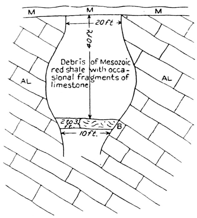
Fig. 11.—Section of Port Kennedy bone cave at time of first exploration, 1871. Redrawn from Mercer. M, M, Triassic shale; AL, Triassic shale; B, black clay, with leaves, etc.
Mercer (1899, p. 269) has given a description of the cave found in quarrying operations. It was located on the right bank of the Schuylkill River, at the village of Port Kennedy and about 2 miles below Valley Forge. Wheatley (1871, p. 236) gave a map which showed the position of the quarries. A comparison of this with the topographical map of Folio 162 of the U. S. Geological Survey shows that they were situated about 800 feet away from the river and facing the valley of an unnamed streamlet. None of the descriptions give the elevation of the cave above the river or above the sea. The river at that place is apparently about 70 feet above sea-level. The 100–foot contour-line runs along near the location of the quarries, but these may have extended back to a higher level. Putting all of the statements together, it appears probable that the mouth of the cave was, in Wheatley’s time, about 50 feet above the level of the river. Originally the surface elevation may have been still greater, but may have been reduced by erosion of the hill. The surface rock here is red shale of the Stockton formation, belonging to the Triassic, and is underlain by the Shenandoah limestone, a member of the Cambro-Ordovician series. This limestone was being quarried in 1871, when a cave was broken into, filled with incoherent materials and exposing fossil bones in abundance. It was visited by Charles Wheatley, who proceeded to make excavations and collect the fossils. In studying the fossils he worked with Professor E. D. Cope and Dr. G. H. Horn. The results were published in Wheatley’s two papers of 1871 and in 318two papers by Cope in the same year (Proc. Amer. Philos. Soc., vol. XII, pp. 15, 73–102). According to Wheatley’s description and his figures, the part of the cave seen was about 20 feet wide at the top, expanded below to about 30 feet, and then narrowed at the bottom, as then recognized, to about 10 feet. The depth was given as 40 feet, but Mercer thinks that this was improbable and that Wheatley’s measurements were to some extent guesses. Mercer (1899, p. 271) stated that this cave might be compared to a bottle of unknown size. It had opened to the surface; and on his page 283 Mercer spoke of it as forming a well-like hole that might have been as much as 70 feet deep. Evidently Mercer here included that part of it which he himself excavated. The materials filling it were, according to Cope (1871, p. 73), the débris of the neighboring Triassic strata. Figure 11 is taken from Mercer’s paper and is a reproduction of a sketch made by Wheatley in 1871. After Wheatley had made his collection the cave was covered over by débris from the quarry and forgotten.
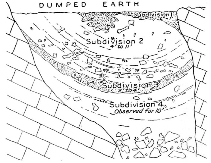
Fig. 12.—Section of Port Kennedy bone cave at time of last exploration, 1894. Redrawn from Mercer.
In the course of further quarrying operations the same cave was broken into again in 1893. Excavations in the materials that filled the cave were made in 1894 by Dr. Samuel Dixon, H. C. Mercer, and others, resulting in the securing of the collection which formed the subject of Cope’s paper of 1894 and his final report of 1899. At this time, according to Mercer, the 319quarrying operations carried on from 1855 had transformed a gently sloping hillside into an amphitheater several acres in extent, walled with perpendicular escarpments of rock, sometimes a hundred feet high. At this time the floor of the quarry had been lowered and the cave was broken into at a level below that reached by Wheatley. Figure 12, reproduced from Mercer’s figure 5, shows the relation of the later excavations to those of 1871. As already stated, Mercer concluded that Wheatley’s dimensions were probably results of guesses, inasmuch as the top of Mercer’s exposure was not more than 30 or 33 feet below the original level of the hilltop. According to Mercer’s figure 5, his own excavation probably extended down about 16 feet below the level reached by Wheatley; but other statements appear to make this somewhat greater.
Mercer wrote that the materials filling the cave had been stratified by the action of water. He recognized four subdivisions, most of which stood higher around the walls than at the center of the cave. Of these subdivisions, the first and uppermost was supposed to mark the lowest level attained by Wheatley. It consisted of fine clay and loam of black color, intermingled with fine and coarse muck, in which were found some remains of small mammals, just what species was not stated. On his chart, his figure 9, a tapir is indicated as occurring in it. Subdivision 2 was composed of from 4 to 11 feet of sandy clay, with fragments of sandstone and limestone, from small ones up to about 2 feet in diameter. In this matrix there were numerous bones and teeth of large animals, but it lacked small ones and vegetal matter. Subdivision 3 was a sandy clay, blackened by vegetable matter and containing numerous bones of vertebrates, large and small. The lowest subdivision, 4, was a zone which was followed down about 10 feet and which consisted of sand, clay, and stones, all of a yellow color. In this were found remains of the larger mammals, better preserved than in the upper subdivisions. At the lowest depth reached the excavation appears to have extended below the level of the Schuylkill River and the water came in so rapidly that further descent was not practicable.
Mercer’s theory of the filling of the cave is expressed in these words, on his page 277:
“Enough had been seen to convince us that a fresh-water flood, rising to a level of from 15 to 20 feet above the present level of the hilltop, hence a general inundation of the whole surrounding country, bearing in its current the clay, stones, and earth of neighboring levels, had tumbled into the fissure, carrying with it the bones of creatures previously denuded of flesh and softened by decomposition.”
And further, on page 284:
“Not unreasonably, therefore, we may suppose, not only that the creatures had perished together, but also that they had perished on the spot or at the chasm—not meeting this fate during a long interval of time, and through a long series of chance tumbles, but suddenly and by force of a common event.”
Are we to suppose that during some summer freshet animals in such numbers were swept away that those that were found in the cave, and doubtless many more which decayed utterly, were only the relatively few that happened to pass over that 20–foot hole? Where, then, were picked up all the other animals that must have burdened the swollen Schuylkill? 320Or did it possibly happen that all the animals that were swept away were in some unaccountable manner directed into that hole? If the current was strong enough to sweep along stones up to 2 feet in diameter, how did it happen to deposit there fine sand and clay, leaves, cones, seeds, and sticks? It is difficult to accept the theory that the filling of the cave was due to a cataclysm such as has been invoked. It seems far more probable that the mouth of the cave was open for many hundreds of years, possibly thousands of them, so that animals, plants, stones, and fine and coarse earth could in various ways get into it. Animals wandering about might inadvertently fall in or be pushed in by the herd. Doubtless at some former time the Schuylkill flowed at a higher level than now, and during times of unusually high-water might have risen to the level of the mouth of the cave and carried into it at each rise some mud, some vegetation, and some animals. The filling was quite certainly a slow process.
To the writer the part of the cavern which was worked and pictured by Wheatley has all the marks of an enormous pot-hole, such as those which have been discovered at Cohoes, New York. While the latter appear to have been drilled out in late Pleistocene times, the Port Kennedy hole must have been fashioned during the early Pleistocene or even in the Pliocene. One may suppose that, after the pot-hole had reached the depth where the constriction was found, the water began to find its way out at the bottom through fissures or passages in the limestone. When this happened, the passages may have been enlarged mechanically or by means of solution, resulting in the formation of the various lower caverns. When the river had been lowered enough to reach only occasionally the mouth of the pot-hole, the latter became choked first by the coarse materials now found in subdivision 4, and afterwards by finer sand and mud.
Some vertebrates of the late Pleistocene or early Recent observed at Carlisle deserve consideration.
In 1850 (Proc. Amer. Assoc. Adv. Sci., vol. II, 1849, pp. 352–355) Professor S. F. Baird gave an account of his explorations in the caves in the region about Carlisle, Cumberland County. One of these caves was near Carlisle, and in it Baird found a large number of animal remains. A second cave, the situation of which was not given, was on the top of a hill and was a vertical shaft 30 feet deep, which opened into a large gallery. It furnished a skeleton of a bear, but this appeared to have only recently fallen into the cave. Another cave was on the bank of the Susquehanna, 0.5 mile below a railroad bridge. It was, therefore, probably near Harrisburg. The entrance was in limestone rock, nearly vertical, and 20 feet deep. Here Baird found many bones, embedded in mud, but of these he obtained only a few. Another cave, apparently nearby, which Baird spoke of as “the main cave,” furnished some of his specimens. Still another cave, probably in the same neighborhood, was the source of his most perfect specimens. This presented a series of galleries near the roof and these were reached by ladders. These galleries were filled with mud, and in this mud the bones were buried. The number of species which he obtained, he reported, was nearly twice the number living there at the present time. Of these fossil species he estimated that about 5 per cent were extinct. 321Baird appears never to have completed his study of his collection. His list designates the animals only by their vernacular names. The mammals consisted of panthers, lynxes, wolves, foxes, otters, bears, muskrats, deer, beavers, and rabbits. There were bird remains in great quantities, and these included wild turkeys, some of great size, swans, wild ducks, and pelicans. There appeared to be 8 or 10 species of tortoises. Bones of snakes were quite common; also scales and vertebræ of fishes, and a lower jaw of a salamander. In the uppermost 2 or 3 inches of mud were many relics of Indians.
Baird supposed that these bones had in most cases been washed in from above through sink holes. This collection, or some of it, was brought by Baird to the Smithsonian Institution; and they, or some of them, are in the collection of mammals; but the bulk of the collection has apparently been lost. All of these animals belong evidently to either the very late Pleistocene or to the Recent period.
A cave at Frankstown has furnished fossils of about Middle Pleistocene time. In 1908 (Ann. Carnegie Mus., vol. iv, pp. 228–233) and again in 1912 (Proc. Internat. Zool. Congr., Boston, 1907, pp. 748–752), Dr. W. J. Holland gave an account of the discovery of vertebrate fossils in a fissure in limestone rock at Frankstown, Blair County. This village is situated on the Frankstown Branch of Juniata River, a little more than 2 miles north of east of Hollidaysburg. The fissure was excavated in a Devonian rock known as the Lewistown limestone. The quarries are reported to be in the village and on the top of a hill that rises about 400 feet above the banks of the Juniata. According to the Hollidaysburg topographical sheet, the 920–foot line crosses the river just above the village. The highest hill, 1,260 feet above sea-level, is 0.3 mile away toward the northwest. In this hill, as Dr. Holland stated, there are several small caves. The one which furnished the fossils appeared to be about 40 feet in length, averaging from 6 to 8 feet in width, and at the most was not more than 10 or 12 feet high. The floor was about 30 feet below the top of the hill. The fissure appeared to have once continued up to the surface, but the opening had been filled with fallen blocks of limestone. The floor of the cave is described as being occupied by about 2 feet of red soil, everywhere traversed by bands and layers of dark materials charged with organic matter. With the finer deposits were mingled fragments of rock, some being large blocks. The fossil remains appear to have been carefully collected, but were mostly fragmentary. They were only cursorily studied at the time of Holland’s writing and nothing has since been published on them. The number of species obtained was estimated to be from 30 to 40. The following genera and species are mentioned:
Meleagris sp. indet.
Megalonyx sp. indet. (p. 31).
Tapirus sp. indet. (p. 203).
Mylohyus pennsylvanicus (p. 214).
Odocoileus virginianus (p. 227).
Cervalces? sp. indet.
Bison sp. indet.
Mammut americanum (p. 69).
Sciurus sp. indet.
Ondatra sp. indet.
Erethizon sp. indet.
Lepus sp. indet.
Ursus americanus.
Arctotherium haplodon.
Mephitis sp. indet.
Canis sp. indet.
Felis? sp. indet.
322After the foregoing had been put in type Mr. O. A. Peterson, of the Carnegie Museum, sent the writer a revised list in which additions are made. The following are the most important:
Cryptobranchus sp. indet.
Rana catesbiana?
Clemmys insculpta.
Blarina sp. indet.
Ænocyon dirus.
Canis priscolatrans?
Spilogale putorius.
Brachyprotoma putorius.
Boötherium bombifrons.
Equus sp. indet.
Besides these forms, remains belonging to bats, various birds, snakes, and batrachians have been recognized. Of the fossils identified generically or specifically those belonging to Megalonyx, Tapirus, Mylohyus, Cervalces, Mammut, and Arctotherium are certainly extinct. Probably, too, the bison and the species of Felis are extinct. There are, therefore, pretty certainly close to 50 per cent of the species which are no longer living. This percentage and the history of some of the genera make it improbable that the assemblage belongs to the Late Wisconsin stage. Some of them could hardly have been living during the Wisconsin, when the foot of the glacier was within 100 miles toward the northeast and northwest. On the other hand, there are no species or genera present which make it necessary to refer the collection to the first interglacial. The assemblage probably belongs to the middle Pleistocene.
Coming now to the very southwestern corner of the State, we find that. Elephas columbi has been met with in the bed of Hargus Creek, 3 miles above Rogersville, in Greene County (p. 150), and E. primigenius on Gray’s Fork of Ten Mile Creek, near Graysville (p. 133). In the Rogersville Folio (No. 146, U. S. Geol. Surv.), Dr. F. G. Clapp described the geology of this quadrangle. On his page 10 he briefly discussed the meager Quaternary deposits of the area. These he referred to the Carmichaels formation, and indicated his opinion that it belonged to very early Pleistocene. On the geological map it is represented as occurring along Ten Mile Creek at and just below Rogersville. The occurrence of a tooth of Elephas columbi just above this town and of E. primigenius just above Harveys (p. 133) renders it probable that other patches of the formation exist further up the stream and along some of its branches, and that the fossils were derived from that formation. It is, of course, possible that small patches of a later deposit exist there.
Reference has been made to the Carmichaels formation. The type locality is found at Carmichaels, on Muddy Creek in Washington County. The geological description of the locality has been presented by Marius R. Campbell in the Masontown-Uniontown Folio (No. 82, U. S. Geological Survey). The formation occurs extensively along Monongahela River and other streams of western Pennsylvania. For information the reader should consult the Geological Survey Folios Nos. 144, 146, 121, 82, and 177. The deposits occur at levels considerably above the present streams and are regarded as having been laid down in old and now abandoned river channels and in tributaries of these. The time when this occurred is believed by many, if not most geologists to belong to the early Pleistocene, the Kansas 323stage, or possibly the Nebraskan. In the opinion of some geologists the glacial ice dammed the streams and caused their valleys to be filled with detritus. More recent Pleistocene deposits, possibly of Wisconsin age, occur at lower levels in some places south of the Wisconsin moraine; and perhaps the age of some of them has not yet been recognized. When remains of vertebrate animals are discovered, it is of great importance to determine, if possible, the exact levels of their origin.
On another page mention is made of the finding of a tooth of Elephas primigenius at Lone Pine (p. 133), 7.25 miles south of southeast of Washington. This village is on Little Ten Mile Creek. No details of the discovery have been received. From Folio 144 of the U. S. Geological Survey it is learned that patches of the Carmichaels formation are found for several miles along Ten Mile Creek, near the southern boundary of the quadrangle. It seems probable that there may be patches of the same deposit along Little Ten Mile Creek, in the neighborhood of Lone Pine.
As detailed on page 70, a mastodon tooth was found many years ago about 1.5 miles south of the village of Hickory, Washington County, about twenty miles southwest of Pittsburgh. Westland Run empties into Chartiers Creek, and this into the Ohio at Pittsburgh. The geology of Burgettstown and Carnegie Quadrangles has been described by E. W. Shaw and M. J. Munn (Folio 177, U. S. Geol. Surv. 1911). No Pleistocene deposits are mapped on the stream mentioned; but just a little lower down, on Chartiers Creek, is a patch of the Carmichaels formation. Below Hickory somewhere there must be a Pleistocene deposit of some kind, and it is more probably early than late Pleistocene.
From the vicinity of Pittsburgh there have been reported remains of the mastodon (p. 69), of Elephas columbi (p. 150), and of an undetermined species of elephant (p. 168). Neither of the elephants is certainly determinable. The mastodon, represented by fragments of bones and teeth, is said to have been found in the river bank, at the junction of Monongahela and Allegheny Rivers. It is impossible to determine the Pleistocene stage to which any of these proboscidean remains belong. As shown on the geological map of the Carnegie Quadrangle (Folio 177, U. S. Geol. Surv.) there are indicated here Pleistocene deposits of early, intermediate, and late stages.
Little information is furnished by a mastodon reported found on Dicks Creek in Butler County. The statements regarding the finding of elephant remains on French Creek near Meadville are vague and valueless (p. 168). Some remains of Elephas columbi have been found at Tryonville, at a depth of 7 feet (p. 150). The town is on the Wisconsin moraine and the elephant probably belongs to the Late Wisconsin.
Nearly a hundred years ago a tooth of Elephas primigenius was reported from a place in Erie County, called Beaverdam (p. 133). From Mr. Clyde C. Hill, civil engineer, Northeast, Erie County, the information is received that Beaverdam is a cross-roads hamlet about 23 miles south of the lake, near the prolongation of the western New York boundary line. This is within the area covered by Wisconsin drift, and it is pretty certain that the animal lived there after or near the close of the Wisconsin stage.
324Just west of Erie a mastodon tooth has been found along Chase Creek (p. 70). Unless there are some unrecognized pre-Wisconsin deposits along this creek, the animal must have lived there at a time after the lake had retired to about its present limits. This would be near the very close of the Pleistocene epoch. The same conclusion must be arrived at from a study of the proboscidean remains (supposed to be those of an elephant) found at Girard.
Brief mention is made here of finds of fossil vertebrates in Pennsylvania which have not yet been mentioned; also, the localities are given where they are found, and citations of the pages where fuller descriptions are furnished:
A horse has been reported from Rutherford, Dauphin County (p. 185), and a peccary, Platygonus vetus (p. 213), from Milroy, Mifflin County. Mastodons have been reported from Tunkhannock, Wyoming County; Berwick, Columbia County; Reading, Berks County; Jackson Township, York County; near Reedsville, Mifflin County; Chambersburg, Franklin County, and Bedford, Bedford County (see pp. 68, 69). Elephas primigenius has been met with at Brookfield, Tioga County (p. 133); and somewhere about Chadd’s Ford, in Chester or Delaware County (p. 133).
OHIO.
(Maps 35, 36.)
The State of Ohio is partly glaciated, partly not. The unglaciated portion forms the southeastern border and constitutes close to 28 per cent of the whole surface. The glaciated area is mostly covered by the Wisconsin drift, which makes up 60 per cent of the whole surface. The remainder is covered by that part of the Illinoian drift-sheet which projects beyond the edge of the Wisconsin. This occupies about 12 per cent of the surface of the State. The unglaciated area contains Pleistocene deposits along the streams, especially along Ohio, Muskingum, Hocking, and Scioto Rivers. Probably the greater part of the materials forming these deposits were brought down the rivers which headed at the foot of the Illinoian and Wisconsin glacial ice-sheets. However, all that part of the country which was not covered by glacial ice was acted on by atmospheric agencies and suffered erosion. Hence abundant materials of non-glacial origin were swept down those tributaries of the Ohio which had their sources in the Alleghany region and down those which flowed through the unglaciated part of the State. Much of these materials was deposited along the banks of these streams and mingled with the débris from the glacial ice-sheet. Doubtless such deposits were being made during the whole Pleistocene epoch and were mostly swept away; or they may have been covered up by subsequent deposits; or the deposits of one stage may in many cases not be distinguishable from those of other stages. A perusal of chapter V of Leverett’s monograph of 1902 (Monogr. U. S. Geol. Surv., vol. XLI, 1902, pp. 228–252) and of the papers there cited, also of others published since that time, will impress the reader with the fact that an old drift, probably of Kansan or pre-Kansan age, has left traces of itself in Ohio just outside of 325the terminal moraine of the Wisconsin drift. This is found especially in Columbiana County; but, according to Wright (2d Geol. Surv. Pennsylvania, Z, p. 207) it extends as far westward as Canton, Stark County.
It is shown in Leverett’s paper that the streams, especially the larger ones, of southwestern New York, western Pennsylvania, and eastern Ohio had, at some time preceding that of this old drift, been deeply excavated into the underlying rocks, and that these ancient channels had become filled by the outwash from the older drift. Furthermore, terraces composed of this drift are now found along rivers of the region mentioned, at heights varying from 150 to as much as 500 feet above the present streams. Those old, deeply excavated valleys may therefore have once been filled to the highest terraces and since that time have been re-excavated to the level of the present streams. The ancient rocky floors in many cases lie now from a few to some hundreds of feet below the beds of the existing rivers. It is easily possible that the bones and teeth of early Pleistocene animals may have been buried in such valley fillings and such terrace deposits. Again, remains of such vertebrates may have been buried beneath the glacial “fringe” that has been mentioned. In such cases it may be impossible for one who is not a glaciologist, perhaps not even for him, to determine the real age of the fossils. It is, therefore, of the utmost importance that a record be kept of the exact spot where the fossil was found, so that at some future time the geology of the locality may be studied by a competent person. Naturally, other information, as that relating to the kind of deposit, depth of burial, elevation of place of burial, and the like, is valuable.
A discussion of the Illinoian drift-sheet, including that part found in Ohio, forms chapter VI of Leverett’s work of 1902 (Monogr. cit., pp. 253–291). As shown by his plate II, Illinoian drift covers a small area in the southwestern corner of the State, along Ohio River; then leaving the river and running first in a northeasterly direction, then directly north, it forms a narrow strip outside the border of the Wisconsin as far north as Richland and Holmes Counties. If it extends further east than this, it is concealed beneath the Wisconsin. It is to be expected that Illinoian drift will be discovered here and there in the greater part of the State beneath the Wisconsin where the latter shall have been penetrated in digging wells, in borings, and where streams have cut down through the later drift-sheet. In such places it will be possible to find remains of animals and plants buried in interglacial deposits laid down before the Wisconsin stage; that is, in either Sangamon or Peorian or even more remote times. On page 269 of the work just quoted, Leverett mentions a case near Lancaster, Fairfield County, where a black mucky soil was found between the Wisconsin and the Illinoian drifts. On page 273 of the same work is mentioned the occurrence of logs and pieces of wood at Bethel, Clermont County, in a gravel-bed beneath the Illinoian drift. This might be interpreted as indicating a deposit belonging to the earliest part of the Illinoian or to the Yarmouth.
The general aspects of the Illinoian drift are described by Leverett on his pages 270 to 285.
326Deposits of Illinoian age may occur beyond the border of the ice-laid Illinoian drift and even beyond the Wisconsin as the result of outwash. Leverett (op. cit., p. 285) mentions the occurrence of what appears to be an Illinoian terrace along Sandy Creek, near Waynesburg, Stark County, at 70 feet above the stream, while the Wisconsin terrace is hardly 40 feet above the creek. High-level terraces are found along Licking and Muskingum Rivers from Hanover, Licking County, to McConnellsville in Morgan County, and are thought to be possibly of Illinoian age, while lower ones belong to the Wisconsin. Illinoian gravels and cobble are likewise met with along Hocking River (Leverett, op. cit., p. 288); also along the Scioto from Chillicothe nearly to its mouth. On lower-level terraces other deposits of Wisconsin age are to be looked for. Again it is seen how important it is that accurate information should be sought regarding the exact spot of interment of any vertebrate remains, as well as the elevation, the depth, and kind of materials passed through.
Map 35 has been prepared to show the distribution of the Wisconsin and Illinoian drift-sheets in Ohio. The driftless area, shown without shading of any kind, occupies the southeastern side of the State and forms a broad tract somewhat parallel with Ohio River. The Illinoian belt lies between this driftless area and the Wisconsin. Naturally it passes beneath the Wisconsin drift and probably underlies most of it. A part of the map is shaded by horizontal lines in order to show the position and extent of former Lake Maumee. This lake was an early predecessor of Lake Erie and emptied into Wabash River. The moraines laid down by the Wisconsin ice on its gradual withdrawal from the State are indicated by the stippled areas and by the letters at the sides of the map. Most of the names applied to these moraines in Ohio differ from the parts of the same moraines in Indiana. The Germantown, Eaton, and Englewood correspond to the Bloomington of Indiana; the Sidney to the Union City; the Loramie to the Salamanie; the Celina to the Wabash; and the Lima to the Fort Wayne.
Map 36 shows the localities where Pleistocene mammals have been discovered in the State and the relation of these localities to the drift-sheets and the moraines.
It is to be supposed that any animal whose remains are found in deposits overlying the Wisconsin drift lived there after the retreat of the ice-sheet from that locality. Any mastodon (maps 5, 7) that has been discovered within the area covered by the old Lake Maumee probably lived there after that lake had subsided. However, it might be possible to find along rivers, or deep cuts along railroads, animals that had lived there during Sangamon times; but this may be supposed to occur rarely. Mastodons, Nos. 34, 37, and 39 of map 7, probably lived and died after later Lake Warren had shrunken into Lake Erie.
Most of the fossil vertebrates that have been found in Ohio belong to the Late Wisconsin; that is, they lived in their respective localities after the glacial ice had retired from those localities. A few fossils may be credited to an interglacial stage, Sangamon or Peorian, which intervened between the Illinoian and the Wisconsin. Inasmuch as in the area occupied by the 327Illinoian drift this deposit may be cut through by rivers or railroads, it is possible that pre-Illinoian fossils might be discovered.
A tooth of Elephas primigenius has been found at Waverly, Pike County, on Scioto River, as recorded on page 134. Along that river there are deposits of gravel and sand which were derived apparently from Illinoian drift, while below these Illinoian deposits is a Wisconsin terrace. The tooth above mentioned appears to have been found in a gravel-pit of the Norfolk and Western Railroad about the year 1900. The writer has not been able to secure any information as to the elevation of the pit. The elephant remains observed by Whittlesey along Scioto River, as mentioned on page 169, were probably buried in the Wisconsin terrace. A mastodon has been found in Pike County (p. 70), but the more exact locality is not recorded.
An important but apparently now lost and therefore indeterminable specimen of elephant is that to which was given the name Elephas jacksoni, described on page 168. It was found in the northwestern corner of Jackson County, on Little Salt Creek, probably a short time before 1838. The probability is that it was found in Wisconsin deposits, but its age is possibly greater. According to Leverett (op. cit., pp. 120, 121, 289), there are in this valley deposits which were probably laid down during the Illinoian stage. An elephant skeleton is reported to have been dug up many years ago in the village of Beverly, Washington County (p. 169), on Muskingum River. Leverett (Monogr. XLI, p. 157) states that glacial deposits belonging probably to the Wisconsin stage are found here at a height of 119 feet above the river. Inasmuch as the greater part of the village is below this level, the elephant probably belongs to Wisconsin time.
Further up the Muskingum, at or near Duncan Falls, there was found about 1857 a tooth of Elephas primigenius (p. 135). The animal probably lived and died there at a time when the Wisconsin glacier was not far away. Other remains of the same species have been described from Zanesville. The bed which contained these is said to be at a height of 37 feet above the river and 20 feet from the natural surface of the ground. Inasmuch as drift outwash, believed to be of Wisconsin age, is built up here to a height of 100 feet above the river (Leverett, op. cit., p. 157), it is wholly probable that the elephant, like the one just described, lived in the vicinity of the Wisconsin ice-front. At Nashport have been discovered in swampy ground remains of Castoroides (p. 273) and of Mammut (p. 70). Although there is at Hanover, Licking County, across Licking River, a great dam of supposed Illinoian age and probably more or less hidden deposits of the same age along the river, the giant beaver and the mastodon just mentioned may not be older than the Wisconsin. Nevertheless, as they were found lying on gravel at a depth of 14 feet, they may have been buried there during the Sangamon stage. Along the eastern border of the State, in Columbiana County, on Salt Creek, in the southwestern part of the county, there was found, about 1845, a tooth of a horse (p. 186). It was discovered while a canal was being excavated and at a depth not to exceed 12 or 15 feet. The locality is apparently some miles south of the Wisconsin moraine. The animal lived there evidently at some time preceding the Wisconsin drift 328stage, possibly after the Illinoian, but quite as likely before the Illinoian. Not far away from where the horse was discovered, apparently on Little Yellow Creek, and probably not far from New Salisbury, there was found, about 1850, a fragment of the lower jaw of a tapir (p. 203). It probably lived at about the same time that the horse did. Near Millport a tooth, referred to Elephas primigenius, has been found (p. 135). The locality is beyond the Wisconsin moraine, but it is impossible to determine whether the beast lived there early or late in the Pleistocene.
At this point may be mentioned the discovery of remains of a peccary, supposed to be Mylohyus nasutus (p. 215), and of Mammut americanum (p. 70) in the southern edge of Lisbon, Columbiana County, apparently along Middle Fork of Little Beaver River. This locality is on the border of the Wisconsin drift-sheet, and the peccary and the mastodon might well have lived there with the horse and the tapir mentioned above.
Not many localities within the area of the Illinoian drift in Ohio have furnished vertebrate fossils.
Lyell in 1843, as stated on page 71, reported that teeth of mastodons and of elephants had been found on the Cincinnati side of the river, on the high terraces.
From Professor N. M. Fenneman the writer learns that Lyell’s reference could hardly apply to any other locality than Terrace Park or Milford. Here are found some fragments of an Illinoian terrace that would hardly be spoken of casually as such, while the Wisconsin deposit is present as an upper and a lower terrace.
In Hyde Park, as detailed on page 71, considerable parts of a mastodon and some remains of a horse (p. 185), probably Equus complicatus, have been discovered. The age of these remains certainly antedates that of the Wisconsin; and it is not improbable that the excavation was carried through the Illinoian drift into an older and probably interglacial deposit. Professor Fenneman writes that this area is only thinly covered by Illinoian drift and is also far beyond the limits of the Wisconsin outwash.
The occurrence of Bison latifrons near Fincastle, in Brown County (p. 257), must be noted. The fine pair of horn-cores now in the Cincinnati Society of Natural History may have been buried in deposits of Sangamon age. It is not, however, impossible that they were in an interglacial bed below the Illinoian drift.
On page 135 there has been given an account of the finding of a skull of Elephas primigenius, somewhat more than a mile east of New Burlington. The locality is treated in proper detail in N. M. Fenneman’s paper entitled “Geology of Cincinnati and Vicinity” (Bull. 19, Geol. Surv. Ohio, p. 158). According to this account the skull was buried in a lacustrine silt laid down probably when the Wisconsin glacier was not far away from that region. The surrounding country is covered with Illinoian drift. This skull is now the property of the U. S. National Museum.
In the collection of the Ohio State Archæological and Historical Society at Columbus there are remains of Platygonus compressus, jaws and good teeth, which were found about a mile north of Chalfants, in Perry County, and along Jonathan Creek. This place is within the area covered by Illinoian 329drift. It is possible that the remains are as old as the Sangamon, but it is also possible that they belong to the close of the Wisconsin stage (p. 215).
The writer knows of no other fossil vertebrates that have certainly been found within the area occupied by the Illinoian till as a surface deposit.
As shown by map 36, by far the larger number of Pleistocene vertebrates which have been discovered in Ohio have been met with within the region occupied by the Wisconsin drift-sheet. One reason for this preponderance is the greater area included. Another reason may be found in the fact that the conditions were more favorable for the preservation of teeth and bones. Much of the country was flat and swampy and the bones buried in clay and muck have always been soaked with water. Also there has been less erosion going on. Erosion leads to exposure and therefore to destruction of skeletons.
On the map referred to are shown the various moraines that were left by the Wisconsin ice-sheet in its retreat toward the north. Inasmuch as most of the burials were in swamps resting on the drift, the animals must have lived and died there after the ice had left that vicinity; how long after one may not be able to determine. The mastodons and elephants which have been found close to the shore of Lake Erie, especially if buried near the surface, must have lived there at or after the time when the waters had shrunken into Lake Warren. Such cases are furnished by the mastodons and elephants found at Amboy (east of Ashtabula) (pp. 137, 150), at Cleveland (p. 79), and in Brownhelm Township, in Lorain County (p. 79). The town of Amboy is about 130 feet above lake level and the gravel-pit which there furnished Elephas primigenius and E. columbi was probably at about the same level. The writer has not been able to confirm any case in which remains of proboscideans have been met with on the south shore of the lake at a level lower than the Warren beach. Mastodons may be traced to a lower level at the western end of the lake. The one found in Springfield Township, Lucas County (p. 77), was buried in deposits only about 45 feet above Lake Erie. As shown by the topographical maps, the descent from this place and from Bowling Green, Wood County, to the lake is a gradual one. It may become possible to follow the presence of the mastodons, the elephants, and the giant beaver in Ohio up to the time when the lake assumed its present level.
For information regarding the several interesting discoveries of the giant beaver (Castoroides ohioensis) pages 273 to 275 may be consulted.
It is hardly necessary to take up one by one all the cases of vertebrates that have been met with within the area covered by Wisconsin drift. With the few exceptions noted below, their geological age is usually to be regarded as Late Wisconsin. Along the southern border of this drift, where the remains are deeply buried, it is not unlikely that they lie in a pre-Wisconsin interglacial deposit. Along Great Miami and Muskingum Rivers there is always a possibility that the fossils may occur in a terrace or in a deep valley deposit of Illinoian age.
About a mile east of Overpeck, Butler County, there has been found the skull of an extinct bear, Ursus procerus Miller (Hay, Geol. Surv. Indiana, vol. XXXVI, 1912, pp. 772–776, figs. 71–73). It was found at a depth of 28 330feet and about 3 or 4 feet above the limestone rock of that region. To the writer it seems quite certain that the Wisconsin drift had been penetrated and that the skull was in either a Sangamon interglacial deposit or something still older.
Columbus furnishes one of the rare cases in which horse remains have been found within the Wisconsin glaciated area (p. 186). We are then required to determine whether or not the horse, Equus complicatus, did not live there after the close of the Wisconsin stage. As said on the page cited, the first remains of horses discovered at Columbus were reported as having been found in crevices of the limestone and in the red clay filling such fissures. An examination of the Columbus Folio (197, U. S. Geol. Surv., p. 8) will show that in such crevices, south of Scioto River, a red clay is found which antedates the Illinoian drift, so that one might fairly refer the horse remains reported by Whittlesey to a pre-Illinoian interglacial stage, possibly the Aftonian. The horse-teeth found in the excavations at the penitentiary close to Scioto River may be as old as those found in the rock fissures, or they may have been buried in a post-Illinoian interglacial deposit. Such deposits have been found at various places in the quadrangle (fol. cit., p. 9).
As to the peccaries discovered at Columbus (p. 214), the writer sees no reason why they should not be regarded as belonging to the Late Wisconsin.
MICHIGAN.
To understand the Pleistocene geology of the southern peninsula of Michigan, it is indispensable to study Monograph LIII of the U. S. Geological Survey, by Frank Leverett and F. B. Taylor. The whole peninsula is overlain by glacial deposits laid down by the Wisconsin ice-sheet. A glance at their glacial map (plate VII) will indicate to the student the complexity of glacial problems in this region. The ice invaded the State from three sides: on the west from Lake Michigan, on the east from Lake Huron, and on the southeast from Lake Erie.
On the west, close to Lake Michigan, is a system of Lake-border moraines. This system has been traced more or less satisfactorily around to Saginaw Bay, Lake Huron. A little farther out, in the southwestern corner of the State, is Valparaiso moraine. This extends nearly to the northern end of the peninsula, where it connects with Charlotte moraine system. Farther in than the Valparaiso system is the Kalamazoo. This extends northeastwardly from the Indiana line to Barry County, where it turns east and at Jackson joins the Mississinawa system reaching northeast from the northeastern corner of Indiana. The Valparaiso and Kalamazoo moraines are in places closely associated. The attack on the eastern side of the State came principally from a lobe which flowed through Saginaw Bay. Nearest Lake Huron, following it around from Port Huron to the northern end of the peninsula and then turning west, the Port Huron moraine connected with the moraine along Lake Michigan.
Farther inland is the Charlotte system. On the north, just above latitude 44°, this joins the Valparaiso moraine, runs southward west of Lansing, then turns eastward, then northeastward, and connects with the 331Defiance moraine, which passes around the western end of Lake Erie. Reaching far out from the head of Saginaw Bay, and concentric with it, to Hastings, 100 miles away, are many minor moraines.
Besides the Wisconsin drift which forms the surface deposit in Michigan, there are, according to present indications, one or more pre-Wisconsin drifts. Leverett (Monogr. LIII, p. 72) mentions several localities where what appears to be more indurated till is encountered, sometimes at a depth of 100 feet. Taylor (op. cit., pp. 289–290) states that “a till older than that deposited by the Wisconsin ice-sheet seems to underlie more or less continuously all of the later, or Wisconsin, drift in Indiana and the southern peninsula of Michigan.” Along the western shore of Lake Huron, north of Port Huron and along the streams, as reported by Taylor (p. 290), there are several exposures of Illinoian till, in some cases as much as 30 to 50 feet thick. In one case there is an old soil at the top of this till. In such old soils it may be possible to find fossil vertebrates of Sangamon or Peorian times, horses for example.
The fossil vertebrates found up to the present time in Michigan are not numerous in species or individuals; all appear to belong to the middle or late Wisconsin times. A peccary, Platygonus compressus, has been found at Belding, Ionia County (p. 215). Two musk-oxen have been discovered in the State. At Manchester, Washtenaw County, has been found a fine skull of Symbos cavifrons (p. 250). At Moorland, Muskegon County, was obtained a skull which has been called Boötherium sargenti.
Details regarding the mastodons which have been found in Michigan are given on pages 80 to 88. Only two localities in the State have furnished remains of Elephas primigenius. These are Three Oaks, Berrien County (p. 137), and Eaton Rapids, Eaton County (p. 137). Elephas columbi has been encountered only once in the State, as far as is known; this was in the northern part of Jackson County (p. 151).
Elephants belonging quite certainly to either E. primigenius or E. columbi, but for one reason or another not determined, have been found in four localities. These are East Saginaw, Saginaw County; Macomb County; Grand Ledge, Eaton County; and Buchanan, Berrien County. (See page 171.)
The giant beaver, Castoroides ohioensis, found a congenial home in the swamps of southern Michigan in the late Pleistocene. It has been met with somewhere in Berrien County; at Adrian, Lenawee County; at Ann Arbor, Washtenaw County; at Attica, Lapeer County; and at Owosso, Lapeer County (pp. 275–276).
INDIANA.
(Map 37.)
Whoever wishes to gain a knowledge of the Pleistocene geology of Indiana, as it is understood to-day, must study Leverett’s two great treatises, forming Monographs XXXVII and LIII of the U. S. Geological Survey. The first is entitled “The Illinois Glacial Lobe,” and was published in 1899; the second has the title “The Pleistocene of Indiana and Michigan and the History of the Great Lakes.” The portion of the latter monograph which 332deals with Michigan was written by F. B. Taylor. On pages 33 to 54 is a very full bibliography of the subject, consisting of about 400 titles.
From the glacial map of Monograph XXXVIII, plates V and VI, the writer has prepared map 37. This shows which part of the State has escaped glaciation, which has been subjected to the action of the Illinoian ice-sheet, and which has been covered by the last, or Wisconsin, glacial ice. It will be seen that about one-sixth of the State, that forming an irregular triangle whose apex is in Brown County and whose base is formed by the Ohio River, has never been covered by glacial ice. North of this is a bilobed area which is covered by till of Illinoian age. The rest of the State (somewhat less than two-thirds of it) is overlain by the débris left by the Wisconsin ice-sheet and subsequent deposits.
This northern area is to a great extent occupied by belts called moraines, along which the materials are usually coarse, often full of boulders, and frequently standing at a higher level than the surface on each side of them. These moraines show where for long periods during its retreat, or perhaps sometimes its advances, the ice-sheet paused and piled up a part of its load of rocks, gravel, and sand. It will be noticed that these moraines are somewhat concentric. On the right of the map are seen those moraines which were left by the ice-lobe which came down Lake Erie and later retired in that direction. Around the southern end of Lake Michigan are the moraines laid down by the ice of the Michigan lobe. The latter will be better seen on a glacial map of Illinois (Monogr. U. S. Geol. Surv. XXXVIII, plate VI). In their advance the two lobes met and coalesced and produced more or less irregular and anastomosing moraines.
On the right hand the moraines of the Erie lobe pass on into Ohio, where, however, they have often been given other names. On the left the moraines of the Lake Michigan lobe continue into Illinois and retain the same names. Both groups of moraines are prolonged into the southern peninsula of Michigan.
On account of the comparatively recent recession of the Wisconsin ice-sheet, the surface has not become eroded sufficiently to drain away the water which was left in depressions of the surface. A large part of Indiana is, or has been until recently, covered by swamps, lakes, and ponds, and in such localities the bones and teeth of vertebrate animals are best preserved during the early stages of fossilization. For this reason great numbers of teeth and bones, sometimes nearly whole skeletons, are met with in draining these swamps.
The southern border of the Illinoian drift, beginning at Cincinnati, follows Ohio River on the Kentucky side to Jeffersonville, then passes west of north into Brown County, whence, turning southwest, it strikes the East Fork of White River in Du Bois County; thence, following White River a short distance, it crosses the Wabash in Posey County. Northward, along this terminal moraine (map 37, figs. 1, 2) of the Wisconsin drift, the Illinoian, passing beneath this, disappears from the surface.
The surface of the Illinoian area is better drained than the Wisconsin area. Fewer fossils are found, and on various accounts they are of less value. Usually the exact locality and kind of deposit is not recorded. 333They may be found washed out of river and creek banks and may have in reality been buried in sediments that were laid down in Wisconsin times by the streams that carried away the mud, sand, and gravel from the glacier. The driftless area has been exposed for many geological ages to the influence of physical and chemical agencies. Its surface is, therefore, more diversified by hills and valleys and streams. In the limestones of this region caves are likely to be found, and these now and then furnish fossil bones and teeth.
During more than one of the glacial stages, perhaps during the earliest, the Ohio has served as the drainage-way for the waters that escaped from the glacial front. This subject is discussed by Leverett in Monograph XLI of the U. S. Geological Survey. As a result of this conveyance of glacial waters, the great trough of this stream may contain here and there deposits of the Illinoian stage or even of older deposits. Remains of Megalonyx (p. 32) and of a horse (p. 186) have been found in the right bank of the Ohio, at Evansville, Indiana. At Bigbone Lick, Kentucky, close to the Ohio, horses have been discovered, Mylodon and Megalonyx. These seem to occur in Sangamon interglacial beds overlying the Illinoian.
The Illinoian drift, probably everywhere in central and northern Indiana, underlies the Wisconsin. For some miles back from its terminal moraine the Wisconsin drift is thin; and possibly the Illinoian may. be found exposed in creek or river banks, or in railroad cuts. Furthermore, Leverett (Monogr. LIII, p. 72) writes:
“Probably a considerable number of the heavy deposits of drift in central and northern Indiana are of pre-Wisconsin age, but as they are largely sand and gravel, or loose-textured material, they can not easily be discriminated from the Wisconsin.”
Such deposits are likely to be covered by only a thin layer of Wisconsin till. In many places in Indiana there have been found, deep down in the drift, old soils, muck beds, and vegetation in various forms. These beds appear to indicate interglacial deposits, most probably the Sangamon. Now, various genera of vertebrates, among them horses, tapirs, and mylodons, are not known to have existed after the Wisconsin glacial stage. If, however, remains of such animals should be collected in central or northern Indiana, or Ohio, or in southern Michigan, they might be reported as having been found in late Wisconsin beds, when really they had been derived from pre-Wisconsin interglacial soils.
It is interesting to observe that when the Wisconsin ice-sheet began to withdraw lakes began to form along its borders. One of these, Lake Chicago, appeared at the south end of the present Lake Michigan and for a long time discharged its waters down Illinois River. Another, Lake Maumee, occupied the basin of Maumee River as far west as Fort Wayne, and emptied down the Wabash. For details connected with the close of the Pleistocene in the region of Lake Michigan the reader should consult Frank C. Baker’s “The Life of the Pleistocene, or Glacial Period” (Univ. Ill. Bull. XVII, 1920).
A brief mention will be made here of the principal Pleistocene vertebrates that have been found in Indiana; also the localities where found, together with citations of the pages where fuller information is furnished.
334The ground-sloth Megalonyx has been collected near Evansville (p. 32). With it were secured remains of an undetermined bison (p. 257), a Virginia deer (p. 228), a horse (p. 186), a tapir (p. 203), and the dog Ænocyon dirus (p. 32). Peccaries have been found in Gibson County (p. 216), in Wabash County (p. 218), and two species at Williams, Lawrence County (p. 217). At the same place was discovered the shell of a box-tortoise. Remains of deer have been discovered somewhere in Vanderburg County, including the existing deer and an extinct species, Odocoileus dolichopsis; at Harrisville, Randolph County; and at Roann, Wabash County. Bisons of an extinct species have been secured at Vincennes (p. 258).
The existing bison appears to have been found in Jasper County (p. 268). Of musk-oxen, Symbos cavifrons has been collected at Hebron, Porter County (p. 252); at Wailesboro, Bartholomew County (p. 251); somewhere in Randolph County (p. 252); and probably in Beaver Lake, Newton County (p. 252). The existing musk-ox, Ovibos moschatus, has been discovered near Richmond (p. 252).
Mastodon remains are not uncommon, especially in the northern half of the State. It is hardly to be supposed that these animals were more abundant there during the late Pleistocene than in many other places in the region east of the Mississippi. The conditions for their preservation were evidently more favorable there than anywhere else, unless in Orange County, New York. Burial in swamp mud kept the bones from decay; and the imperfect drainage protected them from destruction by erosion. The various finds are described on pages 88 to 100.
Elephants are less well represented in Indiana than are the mastodons, but are not rare (pp. 138, 151, 171). Two species were present in the State, Elephas primigenius and E. columbi. Beavers were doubtless abundant, but there appears to be no definite record of any find. However, the giant beaver has been recorded from several localities (pp. 276 to 278).
The great extinct dog Ænocyon dirus was first found near Evansville (p. 32), and the coyote, Canis latrans, has been reported from Boone County. The latter is said to have been found in association with the mammoth (Cope and Wortman, 14th Ann. Rep. Geol. Surv. Indiana, p. 7).
ILLINOIS.
(Map 38.)
As a foundation for a knowledge of the Pleistocene geology of Illinois, the student must take Leverett’s work entitled “The Illinois Glacial Lobe.” This is Monograph XLVIII of the U. S. Geological Survey, a volume of 817 pages, with maps and figures. For a knowledge of the changes which occurred around the south end of Lake Michigan on the retirement of the Wisconsin glacier, see Dr. Frank C. Baker’s work, “The Life of the Pleistocene, or Glacial, Period” (Univ. Ills. Bull. XVII, 1920).
Illinois is eminently a glaciated State, as is to be recognized on Leverett’s plate VI. A little triangle in the northwestern corner, comprising about 600 square miles, and an irregular tract of perhaps 3,000 square miles at the southern end of the State constitute the whole of the unglaciated area out 335of 56,650 square miles. Two glacial stages are prominent, the Wisconsin and the Illinoian. The first was laid down by the Lake Michigan lobe, which sent its icy mass southwestward as far as Shelbyville. Westward the border moraine extends to Peoria, then north to west of Princeton, then northeast to enter Wisconsin 55 miles west of Lake Michigan. Eastward, of course, the deposits of till and the moraines extend into Indiana. North of the Shelbyville moraine is the Champaign. A more powerful moraine is the Bloomington, which forms a loop through the State, extending from Danville, Illinois, through Bloomington to Peoria, where it appears to have overridden the Shelbyville and thence northward, forming the outer border of the Wisconsin drift area. North of this moraine is located that called the Marseilles, while sweeping around the south end of Lake Michigan into Indiana and Michigan is the Valparaiso system.
South and west of the area of the Wisconsin drift is the Illinoian. At Mount Vernon the border crosses the Wabash and traverses Illinois, striking the Mississippi River at Carbondale. It then follows the Mississippi north to a point above Keokuk, where it enters Iowa. It reenters Illinois between Rock Island and Clinton and extends into Wisconsin.
On Leverett’s map (Monogr. XXXVIII, plate VI) there is indicated in northern Illinois, between the Illinoian and the Wisconsin, a tract supposed to belong to the Iowan; but Alden (U. S. Geol. Surv., Prof. Pap. 106, 1918, p. 173) holds that there is no good evidence that the Iowan extends into southern Wisconsin and Illinois. The supposed Iowan (op. cit., plate III) is mapped as Illinoian.
The glacial stage which preceded the Illinoian is the Kansan. This in Iowa extends eastward to the Mississippi, and one might naturally expect that it would be found underlying the Illinoian east of the river. Leverett (Monogr. XXXVIII, p. 105) presents evidences of its presence in western Illinois. Among these evidences is the presence in Hancock and Adams Counties of another till sheet below the Illinoian and separated from it by a black soil. This Kansan or some other pre-Illinoian till sheet has been found in many places in Illinois (op. cit., pp. 107–118).
Animal remains are not likely to be inclosed in the materials of the moraines or of the intermorainal till; but this is possible. A musk-ox or a hairy mammoth might have died not far away from the foot of a stationary or advancing glacier and its bones might have become incorporated in the moraine. Furthermore, inasmuch as any glacial stage began while the glacier was yet in the far north and ended only when it got back there, many non-glacial deposits belonging to that glacial stage were probably laid down south of it; and it would be difficult or impossible to distinguish these from interglacial deposits. However, it was these deposits which were laid down after the glacial ice had withdrawn, whether glacial or interglacial, which are of more interest to the palæontologist, because in them are to be found the fossil remains of animals and plants.
The last of the interglacial stages, that which immediately preceded the Wisconsin and followed the Iowan, is known as the Peorian. This takes its name from a locality a few miles east of Peoria (Leverett, 336Monogr. XXXVIII, p. 187). Here the Shelbyville till sheet is underlain by a bed of fossiliferous loess from 8 to 12 feet in thickness. Beneath the loess is fully 100 feet of Illinoian drift. This loess seemed to the geologists who examined it to be a deposit of more recent date than the Sangamon.
The Peorian interglacial stage and the preceding Iowan glacial stage have received much attention within recent years. In 1917 (Geol. Surv. Iowa, vol. XXVI, pp. 49–212), Alden and Leighton presented the results of their studies on the Iowan drift and the loess associated with it. In 1918 (U. S. Geol. Surv., Prof. Pap. 106, pp. 1–356), Alden dealt with the Quaternary geology of southeastern Wisconsin. The results of these investigations have been to establish the fact that a sheet of till intermediate between the Illinoian and the Wisconsin had been laid down, that which had already been designated as the Iowan; furthermore, that immediately following this there was deposited a covering of loess. It was further concluded that this is the main loess deposit, much of what has been regarded as Sangamon loess being really loess of a later stage, the Peorian.
As no Iowan drift is known to be present in Illinois to separate the loess of the Sangamon from the Peorian, it must be difficult, often impossible in our present state of knowledge, to distinguish the one from the other. The Sangamon loess was laid down probably long after the Illinoian ice disappeared, so that there was time for the Illinoian drift to become leached and otherwise modified and for the accumulation of old soils and peat-beds.
On the other hand, the old soils of the Peorian stage are likely to overlie the loess. Unfortunately, the desired indications of geological age are not always present where bones and teeth are found; or, if present, are not always observed. We must, therefore, make our assignments of fossils to one stage or the other with great circumspection or leave the decision in abeyance.
Reference has already been made to the presence of Kansan drift in western Illinois and of black soils intervening between it and the Illinoian. Such soils must be referred to the Yarmouth interglacial stage. Whether or not still older glacial or interglacial deposits occur in Illinois is problematic.
In Illinois any considerable number of species of fossil vertebrates are rarely found together. The localities are widely scattered and a single species or two in each is the rule (map 38). In later glacial deposits around the south end of Lake Michigan have been discovered the dogfish Amiatus calvus and a sun-fish belonging to the genus Lepomis. Baker (Univ. Ill. Bull. XVIII, p. 85) reported the humerus of the merganser, Mergus serrator, from the same region. The ground-sloth Megalonyx jeffersonii (pp. 33–34) has been found at Urbana, Galena, and Alton.
The few horses are described on page 187. Peccaries have been found at three localities (p. 218). For the specimens of deer that have come to light, see page 229. A species of Cervalces and the moose Alces 337americanus have been met with in Will County (p. 107). The reindeer has been recognized from poor materials found at Alton. The prong-horn Antilocapra appears to have lived in the region of Galena, as shown by Wisconsin specimens. The remarkable antelope Taurotragus americanus has been found at Alton (p. 339). As to the musk-oxen and the bisons, the reader may refer to pages 251, 259, 268; for the mastodons and elephants, to pages 100, 140, 152, and 176.
Of the rodents, the muskrat has been found about Chicago; the pocket gopher at Alton and Galena; the ground hog at the same places (p. 343). The beaver (p. 339) likewise occurs at Alton. The giant beaver, Castoroides ohioensis, has been collected at four widely removed places (p. 279). The rabbit, Sylvilagus floridanus, was included among the animals found in the lead crevices of the region about Galena, where also have been found an extinct species of raccoon, Procyon priscus, what appears to be a large dog Canis (or Ænocyon) mississippiensis, the coyote, Canis latrans, and the fox Urocyon cinereoargenteus. The bear, Ursus americanus, and the common gray wolf, Canis nubilus, appear to have existed in the middle Pleistocene at Alton.
A skull of Felis couguar, the yet existing panther or mountain lion, has been found in Randolph County, in the bed of Kaskaskia River. It probably belongs to the late Pleistocene.
A considerable fauna has been secured in the lead region about Galena, in Illinois, Iowa, and Wisconsin. The collectors and describers of this were not careful to designate the localities, and in some cases these can not at present be determined. These collections are discussed on page 343, in the account of the geology of Wisconsin.
An interesting list of Late Wisconsin mammals has been secured near Whitewillow, Kendall County. From Dr. E. S. Riggs, of Field Museum of Natural History, and from Netta C. Anderson’s list, the writer learns that at least six skulls of the common mastodon, together with many other parts of the skeleton, has been taken from a well 10 feet in diameter (p. 109). Above, there were bones of bison (p. 269), deer (p. 229), and elk (p. 240). It is stated that a layer of these about 2 feet thick was encountered at a depth of about 5 feet.
Mr. George Langford, of Joliet, states that he made a collection of bones 15 miles west of Joliet and 5 miles west by north of Minooka. The more exact locality he gave as township 35 north, range 8 east, and probably section 27, on the farm of John Bamford. Apparently both Riggs and Langford obtained their materials at the same spot. The latter has sent the writer some bones from this place, including those of Cervalces, Alces americanus, and a leg-bone of some undescribed species of sheep or goat. He also reported the finding of the elk. For other remarks see page 269. This locality is in the region mapped by Leverett as having been occupied, after the retirement of the Wisconsin glacial ice, by temporary lakes. The presence of the moose here seems to indicate a climate somewhat severer than that now prevailing in that region. Since the occupancy of the country by the European race the moose has not been known to come further south 338than northern Wisconsin. The list of species obtained is as follows: Mammut americanum, Ovis sp. indet., Odocoileus virginianus, Cervus canadensis, Alces americanus, Cervalces roosevelti?.
A brief description of the bone referred to Ovis is presented. The lower epiphysis is missing, but an allowance is made for this (fig. 13).
Comparisons of the metatarsals of a sheep, of a goat, of Næmorhedus, and of Orvis sp. from Whitewillow, in millimeters, together with indices in one-hundredths of the length.
Measurements taken. Næmorhedus. Indices. Capra hircus 155623. Indices. Sheep. Indices. Whitewillow animal. Indices.
Length on outer border of bone 170 100 120 100 152 100 185± 100
Side-to-side width of upper articular surface 36 21.2 23 19.2 23 15.1 37.5 20.3
Fore-and-aft width of upper articular surface 30.5 17.4 20 16.7 21 13.8 37.5 20.3
Side-to-side width, at middle of length 23 13.5 15 12.5 14 9.2 19.0 10.3
Fore-and-aft width at middle of length 17.5 10.3 11.5 9.1 13 8.6 20.0 10.8
Side-to-side width at lower end just above epiphysis 38 22.4 27 22.5 27 17.8 35.0 19.5
Side-to-side width across lower articular surface 41 24.1 27.2 22.5 25 16.4
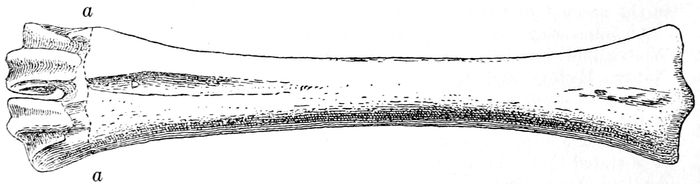
Fig. 13.—Metatarsal of undetermined species of Ovis? From Kendall County, Illinois.
From Alton, the U. S. National Museum has come into possession of a collection which furnishes 15 species of fossil mammals. This was made some time before 1883 by Hon. William McAdams, of Alton. It was briefly mentioned by him at the Minneapolis meeting of the American Association for the Advancement of Science in 1883 (Proceedings, vol. XXII, p. 268). Apparently the collection was secured for the U. S. Geological Survey by Professor O. C. Marsh and remained at Yale University until after his death. The species were described by the writer in 1920 (Proc. U. S. Nat. Mus., vol. LVIII, pp. 109–117). This collection seemed especially valuable because the species were found inclosed in supposed nodules of loess. In our country 339the loess has furnished few such remains. The following is the list of the species as determined. Those marked by a dagger are extinct.
†Megalonyx jeffersonii (p. 33).
†Equus sp. indet. (p. 187).
†Platygonus cumberlandensis? (p. 219).
†Sangamona fugitiva.
†Cervalces roosevelti?.
†Rangifer muscatinensis? (p. 246).
†Taurotragus americanus.
†Symbos cavifrons (p. 254).
†Bison sp. indet. (p. 259).
†Mammut americanum (p. 102).
Castor canadensis.
Marmota monax.
†Castoroides ohioensis (p. 279).
Geomys bursarius.
Ursus americanus.
Of these 15 species at least two-thirds are now extinct. This large number might appear to indicate that the time of their existence was rather early in the Pleistocene. However, it is quite certain that the loess belongs somewhere about the middle of the Pleistocene; and there are no species that require an earlier date.
After the writer’s descriptions of the fossils had been published, an important paper on the geology of the locality was issued (Jour. Geol., vol. XXIX, 1921, pp. 505–514) by Professor Morris M. Leighton, who had been commissioned by the Illinois Geological Survey to visit and study the deposits involved. With the aid of Mr. John D. Adams, son of the collector of the mammalian fossils, Professor Leighton succeeded in finding the quarry in which most of the fossils had been collected.
At one quarry in Alton Professor Leighton obtained the following geological section, the description of which is here somewhat abridged:
Feet.
Soil loessial, dark brown, leached 1
Loess, brown above, grading below into buff, leached 4 to 5 feet, maximum thickness 20
Loess distinctly more reddish than that above; many fossil snails, thickness about 30
Glacial till, reddish, with pebbles of Canadian rocks; more oxidized than overlying loess; thickness 1–3
Mississippian limestone, about 100
The concretions which hold the mammalian fossils were found to lie between the upper surface of the till and the overlying loess; occasionally a concretion bears a drift pebble. The concretions have resulted from the lime which in solution was brought down from the loess and again precipitated so as to cement the loess materials around the fossils.
Professor Leighton was not able to determine definitely the ages of the till and of the two deposits of loess. As to the till, its geographic location suggested that it belonged to the Illinoian, but it had many of the characteristics of the Kansan. The latter is believed to be present at St. Louis and other localities not far away. Before the overlying reddish loess had been deposited the till had suffered weathering and erosion, indicating a considerable lapse of time had intervened. The lower reddish loess presented many evidences that it is a deposit distinct from the upper buff loess; and there seemed to be some indications of at least a short interval between them. Leighton’s conclusion was as follows:
If the drift is Kansan in age, the reddish loess may be Sangamon; if, on the other hand, the drift be Illinoian, the reddish loess probably is 340Peorian. It is unlike any Peorian loess of which the writer knows, but the color does not necessarily preclude that possibility.
As to the upper loess, Leighton thought it might be of early Peorian age, but possibly of early Wisconsin. However, his final conclusion was thus expressed:
“If the till proves to be Kansan in age, the weathering of the drift may be credited to the Yarmouth interglacial epoch, the mammalian fauna to late Illinoian or early Sangamon times, the reddish loess probably to the Sangamon, and the buff loess to the Iowan.... However this may be, the Illinoian and Sangamon epochs are post-mid-Pleistocene from the standpoint of duration of the Pleistocene and the fauna represented by the McAdams collection may be regarded as post-mid-Pleistocene.”
WISCONSIN.
The greater part of this State is covered by the drift-sheet which has derived its name from the State, but in the southwestern corner is a considerable tract which has never been subjected to glacial action. A small part of this area extends southward into Illinois and another part into northeastern Iowa. In Wisconsin it reaches eastward to Baraboo. East of this driftless area is a tract lying along the southern border of the State and reaching eastward about to 88° 40′ longitude, which is covered by the Illinoian drift.
The most detailed geological survey of any part of Wisconsin, so far as regards the Pleistocene, is that made by Dr. W. C. Alden, of the U. S. Geological Survey, of the area comprised between the boundary of the State on the south and 44 degrees of latitude on the north and between Lake Michigan on the east and 90 degrees of longitude on the west. On the western side it joins the Mineral Point Quadrangle, to be mentioned further along. There is, therefore, a wide strip surveyed across the whole State. The area treated by Alden is, of course, nearly entirely covered by Wisconsin drift. In the southwestern corner a considerable part of the driftless region is included. East of this, as already stated, is a tract which the Wisconsin ice-sheet did not reach and which shows Illinoian ground moraine and some terminal moraines of Illinoian drift. This narrows as it approaches its eastward limit.
Alden (p. 166) informs us that at no place in the area subjected to vigorous glaciation by the Wisconsin ice-sheet had soils or vegetal deposits been found between the Wisconsin drift and the earlier drifts. At several places, however, deposits have been discovered which probably belong to earlier glacial stages. Just outside the area mapped by Alden, in Calumet and Outagamie Counties, Lawson (Bull. Wis. Nat. Hist. Soc., vol. II, pp. 170–173) has recorded the discovery of much wood and other vegetable matter. Baker (“Life of the Pleistocene,” p. 317) has referred the deposits to the Sangamon. These interglacial deposits of uncertain age need not be here noted further. In this Wisconsin area some remains of mastodons and elephants have been met with, but all are relics of a time after the partial or complete recession of the Wisconsin glacier. Remains of two individuals of Elephas primigenius have been found in Milwaukee (p. 143). It is evident that they lived there after the withdrawal of the Wisconsin ice-sheet. 341One of these was buried beneath peat and clay at a depth of 10 feet or more and at a level of about 100 feet above the present level of Lake Michigan.
At Dover, in Racine County, in 1878, a proboscidean tusk and some bones were found in a peat-bog. They have been identified as those of a mastodon, but of this one can not be certain. The age of the deposits is that of the Late Wisconsin stage, after the withdrawal from that vicinity of the ice, but how long after one can not say. The Milwaukee Public Museum has a tooth of a mastodon (p. 111), labeled as found at Waukesha. Its geological age is that of the other remains here referred to. In the collection of the University of Wisconsin is a large vertebra of a proboscidean which was found in Lake Monona. Its time of burial must have been late Wisconsin. Inasmuch as no remains of vertebrate animals have yet been found in Wisconsin, in the area covered by the Illinoian drift, it is not necessary to dwell on this region. It is not certain that there is beneath it a still older drift; but there are, according to Alden, some indications of such deposits.
For a knowledge of the driftless area, first of all, may be consulted the report made by Chamberlin and Salisbury in 1885 (6th Ann. Rep. U. S. Geol. Surv., pp. 199–322, with plates). Alden’s work above referred to maps a part of the region. Grant and Burchard have studied the geology of the Lancaster and Mineral Point Quadrangles (Folio U. S. Geol. Surv. 145). Their text-figure 1 is here reproduced, inasmuch as it shows the relation of the region to the surrounding glaciated areas (fig. 14). The topographical map of Folio 145 and that of Chamberlin and Salisbury will show the uneven character of the surface. This has resulted from the erosion undergone during the whole of the Pleistocene. Much of the area is covered with a coating of loess. Along Mississippi River this may be as much as 10 feet thick, but at a distance of from 30 to 40 miles it becomes reduced to a few inches. Considering this erosion, one might conclude that few vertebrate remains would be preserved; nevertheless they are not wholly missing.
In 1862 (Geol. Surv. Wisconsin, vol. I, p. 136), J. D. Whitney stated that he had found in a crevice at Blue Mounds, Wisconsin, remains of the mastodon (p. 111), a peccary (p. 219), bones and teeth of a buffalo (p. 270), and a wolf which he referred with doubt to Canis latrans. The depth was uncertain, but it may have been as much as 40 feet. The fossils were embedded in reddish clayey loam, the usual crevice earth. On page 422 of the same volume, Jeffries Wyman referred the wolf remains to two distinct species, Canis occidentalis and C. latrans. In 1876, Dr. J. A. Allen (Amer. Jour. Sci., ser. 3, vol. XI, pp. 47–49) described from the same lot of bones the species C. mississippiensis. This apparently did not include jaws and teeth that Wyman had referred to C. occidentalis. In Wyman’s paper, on page 422, he assigned three teeth to Dicotyles torquatus, an existing peccary, without stating that it had been found at Blue Mounds. In 1869 (Jour. Acad. Nat. Sci. Phila., ser. 2, vol. VII, p. 384), Leidy referred this peccary to his Dicotyles lenis, an extinct species. Inasmuch as the peccaries found at Galena were identified by Leidy (Whitney, vol. cit., p. 424) 342as Platygonus compressus (p. 218), it appears pretty certain the Dicotyles lenis (Tagassu lenis) was among the fossils collected at Blue Mounds (p. 219). It must, however, be kept in mind that Whitney, on page 35, stated that he had collected bones and teeth of the same animal near Dubuque, Iowa. Allen regarded the buffalo as belonging to an extinct species; but it is really undeterminable. Accordingly there may be credited to this locality the following species: Tagassu lenis, Bison sp. indet., Mammut americanum, Canis nubilus (C. occidentalis), C. mississippiensis, C. latrans.
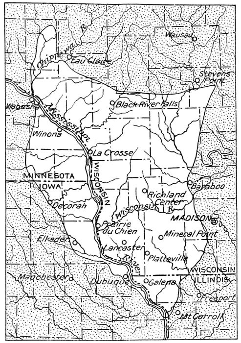
Fig. 14.—Relation of driftless region of Wisconsin, Iowa, and Illinois to glaciated areas. From Grant and Burchard. Unshaded area represents driftless region.
In Whitney’s report, on page 133, he announced the finding of a large quantity of bones of mastodons at Sinsinawa Mound (p. 111), but he did not know at what depth they occurred. It seems probable that they had been met with in one or more crevices.
It seems probable that the animals found in crevices in the lead region of Wisconsin, Illinois, and Iowa belong approximately to one geological 343stage of the Pleistocene. The following appears to include all known to have occurred in such situations:
Megalonyx jeffersonii?.
Platygonus compressus.
Tagassu lenis.
Odocoileus virginianus?.
Cervus canadensis.
C. whitneyi.
Antilocapra americana.
Bison sp. indet.
Mammut americanum.
Marmota monax.
Microtus sp. indet.
Geomys bursarius.
Sylvilagus floridanus? (Lepus sylvaticus).
Anomodon snyderi.
Procyon priscus.
Canis nubilus (C. occidentalis).
C. mississippiensis.
C. latrans.
The writer was at one time inclined to believe that these animals belonged to the time succeeding the withdrawal of the Wisconsin ice-sheet. Baker (“Life of the Pleistocene,” p. 353) thinks that they belong probably to the Peorian, inasmuch as the region is covered by Iowan loess, beneath which many of the bones have been found. It is quite probable that those crevices were open during at least some part of the Pleistocene and that animal remains collected in them. The fossils are reported as being sometimes inclosed in a matrix of cave or fissure materials which are cemented together by iron. The considerable number of extinct species, certainly 7 out of about 18, makes it probable that the fauna is not so recent as the Late Wisconsin.
It appears to be determined that the Iowan loess was formed immediately after the retirement of the Iowan ice-sheet. It might, therefore, be a question whether all of these animals might have got into those crevices in time to be covered in by the loess. On the other hand, the Illinoian drift was, for a long time, exposed to weathering and erosion before the Iowan drift and loess were laid down. Also, the Sangamon interval was probably much longer than the Peorian, so that the chances for the accumulation of the fossils were greater. It seems, however, that we can only say that the fossils are post-Illinoian and probably pre-Wisconsin.
Besides the vertebrate fossils referred to above, a few others, especially mastodons (pp. 110, 111), have been found at other places, but so little is known of the conditions of their interment that they furnish little geological information.
A very interesting region is found in the western part of the State, in Dunn and Pepin Counties. This has been examined with great care by Dr. Samuel Weidman, State geologist of Wisconsin. About Menomonie there are several brickyards, whose excavations furnish opportunities for studying the formations at that point. Sections of one of these brickyards are described and illustrated by Dr. E. R. Buckley, in Bulletin VII, part 1 (1901), page 194, plate XXXVII. A section and brief description is found also in a paper by Dr. Hussakof (Jour. Geol., vol. XXIV, p. 688). In that region are found outwash gravels which have been definitely correlated by Weidman with Iowan drift. In some places this is overlain by loess. These gravels vary from 10 to 20 feet in thickness at Menomonie. Beneath the gravels are found lacustrine clays varying in thickness from 20 to 40 and even 60 feet. These are stratified and consist 344of layers from 1 to 12 inches in thickness, with intervening thin layers of sand. Toward the bottom the sand increases in amount. Beneath the clay-bearing formation is a bed of sand attaining a maximum thickness of about 150 feet. This is underlain by coarse sand and gravel. The lacustrine clays and the underlying sands and gravels are included by Weidman in his Menomonie formation, and this is believed by him to be of Sangamon interglacial age. In northwestern Wisconsin are found other glacial deposits believed to belong to the Illinoian drift epoch.
In the lacustrine clay at Menomonie have been found remains of the great lake trout, Cristivomer namaycush (Hussakof, as cited above), of a deer (p. 230), a caribou (p. 247), and probably a mastodon. The deer is represented by a single vertebra, identified by Dr. W. D. Matthew. The supposed mastodon is indicated by the distal end of the right femur, the caribou by an antler of a young and probably female individual and by the shaft of a large individual.
At Woodville, in St. Croix County, about 20 miles west of Menomonie, has been found a forest bed regarded as belonging to the Aftonian. This was described by Arthur Koehler (Amer. Forestry, vol. XXVI, Feb. 1916, p. 92, 3 figs.). Wood was found that was identified as that of spruce.
In 1913 (Science, n. s., vol. XXXVII, p. 457), in a brief abstract, Weidman reported that in Wisconsin he recognized drift deposits of Wisconsin, Iowan, and Kansan ages and another still older. No localities were mentioned, but his statements were doubtless based mostly on his work in the western part of the State. The loess was found to be laid down after the Iowan and before the Wisconsin. Interglacial deposits were found between the Kansan and the Iowan.
In 1905 (Jour. Geol., vol. VIII, pp. 238–256) and in 1910 (Jour. Geol. vol. XVIII, pp. 542–548), Dr. R. L. Chamberlain presented the results of his investigations on the “Pleistocene Geology of the St. Croix Region in Western Wisconsin.” His conclusion (p. 548) was that in that part of the State there were present (1) a surface mantle of gray Wisconsin drift deposited by a glacier from the Keewatin center; (2) red Wisconsin drift deposited by a glacier coming from the Labrador center; (3) a red drift left by an ice invasion from the Labrador center, its age consistent with Illinoian; (4) a grayish-black till that had come from the Keewatin center and whose age was probably Kansan.