5. Exploration of the Western Borders of the Libyan Desert: Ounianga-Erdi
Reading edition
After drawing up the map of the western part of Borkou, subsequent to my reconnaissance in March and April of the various oases that succeed one another between Faya and Ain Galakka on the south and Gouro on the north, I devoted the last quarter of 1914 to an exploration of the unknown regions situated further east. Over and above their geographical interest, the said regions were of great military importance. My object was, in fact, to ascertain whether a counter-attack by the Senoussists, starting from Koufra and crossing the Libyan desert, could easily hope to escape the vigilance of our camel-corps patrols and fall on the remoter borders of Borkou and Ennedi.
From Faya to Ounianga.—With this intention I left the oasis of Faya on 1 October 1914, at the head of a small escort, taking with me only some thirty lean camels tired and mangy, only capable of short stages and of carrying light loads. The result was that I spent nine days in covering the 117 miles between Faya and Ounianga, a journey that offers no difficulties and is usually completed in five or six stages. The points at which water may be found are frequent—at least one every 20 miles—and permanent; but grazing-grounds were almost non-existent at that time in consequence of the eleven years’ drought the country had just suffered from. The rain that had fallen in August had, it is true, made a few green blades spring here and there, and they were eagerly snapped up by our camels as they passed; but they were still so scattered among the broken rocks that they rather emphasized than diminished the desolate barrenness of these dreary solitudes. From place to place, round a water-hole, one found a few wretched acacias, bushes of rtem or tufts of akrech. By chance one would come across what had once been a field of dried-up hâd whose thorny branches were grey with dust; but in a general way the landscape was disappointingly bare, and I wondered anxiously how long my camels would hold out on this starvation diet.
The route passed alternately through hamadas of sandstone, the blackened rocks of which emerged from irregular dunes, and through sandy plains into which one sank, raising thick clouds of dust finer than ashes. We did not meet a living soul on the way, except a detachment going back to Faya, and a little caravan consisting of two delegates of the Grand Senoussi coming from Cyrenaica on their way to Fort Lamy as an embassy to the commander of the territory. I spent an afternoon with them near the wells of Eddeki, and so had the pleasure of offering them tea. The chief delegate, Si Mahmoud Sheikh, was a Khoan of fairly high rank in the Senoussist confraternity. His appearance was that of a good Mussulman “brother” by no means indifferent to the good things of this world; fifty years old, and of a fine corpulence, he had a fair but sunburnt complexion, grey hair, a black beard, a round face, thin lips, small eyes, and a sensual nose. He was dressed all in white, walked with gravity, and spoke little. His attitude, free from arrogance, was not without a touch of awkwardness, and his reserve concealed but ill his uneasiness about the fate that might await him during his long journey among the infidels.
His companion, Abdallah Ghariani, was younger and of a very modest rank among the Khoans. He had a jovial, bustling manner, and talked volubly, but his eyes were sly and shifty. While we drank tea flavoured with mint, he boasted of the pacific intentions of Ahmed Sherif, insisted on the desire of the Confraternity to maintain active commercial relations between Cyrenaica and the Wadai, and on the necessity for suppressing the Toubou brigandage that hindered the march of the caravans. In conclusion, he declared that he had eaten no meat for a long time and begged me to make him a present of a small quantity of smoke-dried meat—a precious commodity in the desert, where the resources of hunting do not exist.
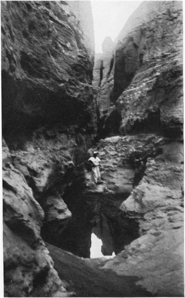
NATURAL CISTERN, ERDI
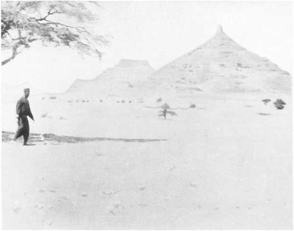
THE PEAK OF DIMI (600 m.), ERDI
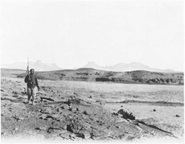
THE PEAKS OF DOURDOURO (1000. m.), ERDI
Ounianga.—I reached the valley of Ounianga on October 9 in the morning, and was not a little astonished at failing to see the palm plantation till the moment of entering it; for, unlike those of Borkou, which can be seen from a distance, the oasis of Ounianga is hidden in a rocky excavation some 30 yards in depth and 4 or 5 miles long by 1 or 2 wide. The landscape thus formed is incomparably picturesque: a great sheet of calm water with blue shadows, edged with rosy-tinted beaches of sand, and fringed with green palm-trees stretched within a circle of bare wind-carved sandstone whose sombre hues cast here and there, under the blazing sun, warm shadows glowing with red or gold.
But it must be recognized that in spite of its beauty the palm plantation of Ounianga is but wretchedness, gloom, and disappointment. The inhabitants, known as Ounias, are few—some hundreds at most. On the other hand, millions of flies fiercely exercise their buzzing activity for fourteen hours a day on man and beast. The soil is unfruitful, and produces hardly anything but dates. The foodstuffs necessary to life—cereals, butter, smoke-dried meat—are brought at great cost by caravans coming from Abéché to seek the supplies of salt from Arouelli needed by the inhabitants of Wadai. Even the camels cannot live in the neighbourhood for want of enough pasture, and from this cause our little garrison had the utmost difficulty not only in getting supplies, but in fulfilling the mission of watching the approaches of the frontier, and especially the great road from Koufra that emerges from the Libyan desert in the region of Tekro Arouelli.
It occupied at the north end of the lake a little rectangular fort, solidly built, but surrounded at a short distance by rocks that blocked the view and overlooked it to the north and east. It had not been possible to find a more favourable site, offering at the same time extensive views and an easily accessible water-supply.
I devoted two days to different tasks (inspections of the garrison, interviews with the Ounia chiefs and with two Khoans, former governors of the country in the time of the Senoussist domination, and so forth), and set out again on October 11 to visit the last water-points before entering the Libyan desert.
The Libyan desert is still almost completely unknown, no European traveller having been able as yet to cross it from side to side, whether from north to south or from east to west. In 1870 Gerhardt Rohlfs visited the northern part, as far as the oases of Koufra; a quarter of a century later British officers penetrated the south-eastern region as far as Bir Natrun, about 200 miles west of the Nile. On our part, we have been able to explore the south-western district and to obtain in respect of the central part fresh information, which it will not be easy to verify and extend until the French, British, and Italian governments combine in organizing for that purpose a geographical expedition, which would be of considerable scientific and even political interest.
I first took the direction of the salt-pits of Arouelli, situated 28 miles to the northwards, where I met a caravan that had just loaded up with 30 tons of salt for the Wadai markets. The salt-bed lies at the bottom of an absolutely bare sandy depression, covering some 25 acres. The bed of salt, which is only about 6 or 8 inches thick, is on the surface, and more or less mixed with sand. The water-bearing stratum lies at a depth of 5 or 6 feet, and the water is naturally very salt. The water, rising to the surface by capillarity, evaporates, forming the salt crust that the caravans carry away in pieces, and which the natives of the Wadai and the countries bordering on it consume without further preparation. If one may trust the information supplied by the Ounias, the salt crust forms again about three months after being taken away, so that the output of the Arouelli pits would amount to nearly 100,000 cubic metres of salt annually, an output sufficient to satisfy the culinary needs of more than ten million people, and worth on the spot, as prices were before the war, some fifteen million francs.
From Arouelli I went eastwards to fix the position of the well of Tekro, where there is also a deposit of salt which is not worked, the admixture of sand being too great. The well of Tekro is particularly important, because it is situated at the extremity of the great caravan route joining the Mediterranean to the Soudan by the oases of Koufra and the well of Sarra. The water is abundant and fairly fresh, but the vegetation is reduced to a hundred clumps of siwak and a few tufts of grass of no value for the feeding of camels.
The Route towards Koufra.—Between Tekro and Koufra the distance to be covered is about 350 miles, about half of which had just been reconnoitred by Lieutenant Fouché, commanding the garrison of Ounianga. Marching in a general direction north-north-east he had first crossed a rocky zone of slight elevation, spending four hours in doing so; then for two days he traversed an immense sandy plain, bare of all vegetation, with here and there stretches of rock surface level with the ground; broken lines of rocky heights were visible in the distance to east and west. These heights went to join the plateau of Jef-Jef, in the direction of which he marched for twelve hours during the third day. On the fourth, he found himself in a vast plain from which the Djebel Habid, 50 miles away to the east, can be seen during the first few hours. The fifth day ranges of moving sand-dunes that served as landmarks for the guides were observed to the north-west, and at last, at nightfall on the sixth day, he reached the well of Sarra, lying in a hollow running from south-west to north-east and 30 metres deep.
The site of the well was chosen by the revered Sidi el Mahdi about 1898, and the works began almost at once. The boring, all done with picks and crowbars, was effected in hard reddish sandstone, by gangs of six workmen, relieved every month, and supplied with food and water by an endless succession of camel-convoys. At the end of eighteen or twenty months of uninterrupted work the water was at length found, clear, fresh, and abundant, at a depth of 80 yards, and since then the crossing of the Libyan desert has become relatively easy, the longest stretch without water being reduced to about 180 miles, whereas it was formerly almost 300. From the well of Sarra to Koufra the distance to be covered is only about 160 miles and offers no further difficulties, thanks to the intermediate well of Bechra.
What makes the journey from Ounianga to Koufra particularly troublesome is the total absence of pasturage for 500 miles, a state of things that results in the loss of many camels on every journey. The only good pasturage in the whole region is said to be found 80 or 100 miles to the east of the Sarra well, in the Djebel El Aouinat, an unexplored mountain mass of an extent not exceeding 1500 to 2000 square miles, as I am informed, and whose altitude may be roughly put at from 4000 to 5000 feet. It goes without saying that I only give these figures as a mere indication, and as subject to caution in every respect.
The break in continuity between the surveys of Rohlfs from the Mediterranean to Koufra and ours from the Wadai to the well of Sarra is consequently reduced to about 180 miles; but this gap does not seem likely to be bridged before Italy proceeds to an effective occupation of the oasis of Koufra, which falls within her sphere of influence.
Having ascertained the site, depth, and value of the Sarra wells, Lieutenant Fouché, in accordance with his instructions, set himself to march back to Ounianga, but the return journey was particularly dramatic. For from the very first day his guide led him directly south, instead of marching south-south-west. One is justified in supposing that he meant to lead astray in the desert the detachment whose camels were so exhausted that everybody went on foot, and whose store of water was limited to a little less than a gallon a day per man. Astonished at this unaccustomed deviation, the lieutenant drew the guide’s attention to it, but the latter answered: “Do not be uneasy, we are on the right road.” But when he judged that the column was far enough from the tracks left by the outward journey, he replied to a fresh observation made by the lieutenant: “You are probably right, for I no longer see my usual landmarks; but if you would lend me a camel and a skin of water, I would go and find our tracks of the other day, and as soon as I had found them I would come back to look for you.” The lieutenant thought it wiser to turn guide himself, and, compass in hand, he put himself at the head of the caravan, with what anxiety may be guessed! An error of direction of a few degrees—quite a usual thing in marching by the compass with no natural landmarks—might work out at a matter of 15 miles in a distance of 180, that being the distance to Tekro. And the well had to be found, in the immensity of the desert, before the detachment’s scanty water-supply gave out! The black soldiers’ thirst was aggravated by the crushing heat; reduced to a daily ration of a little less than 4 quarts of water, they no longer ate any solid food. The camels, grown weak, slackened their pace. The men, uneasy at not coming across their traces of the outward journey, thought themselves hopelessly lost. Their feet, swollen with weariness and made painful by the burning sands, seemed incapable of carrying them to the end of that interminable plain, torrid and unchanging, where the air vibrated as it vibrates above an overheated stove, creating all along the route deceptive mirages, ceaselessly dissolving and reappearing. After a while some of them lost heart and wanted to stop, preferring to wait for death where they were rather than go on with an aimless march. The lieutenant tried to cheer them up by singing the praises of his compass, and promising them that on the morning of the seventh day the three familiar rocks near the well of Tekro should appear before them on the horizon. Incredulous, but respectful, they betook themselves again to their journey, advancing automatically behind the camels as exhausted as themselves, and by some miracle, on the promised day and at the promised hour, they saw faintly outlined against the far horizon the rocks of their salvation! A few hours later, bivouacked round the well of Tekro, the brave fellows who had just covered 350 miles on foot in fourteen days in conditions of the utmost hardship, had forgotten their weariness and were contemplating with respect, on the lieutenant’s table, the “good little iron” that had saved them from the most horrible death.
As for the guide, he was left unmolested, his criminal intention not being susceptible of absolute proof. It was the wisest course to take, for by punishing him without proofs, all we should have gained would have been to terrify men whom we might need later on! In the desert, the best guides may have their weak moments!
From Tekro to Ounianga.—From Tekro I came back to Ounianga, and continuing eastwards by the lakes of Little Ounianga and N’Tegdey I reached the salt-pits of Dimi, after crossing a chain of little sand-dunes about 50 feet high, stretching from north-east to south-west, and extending from 5 to 6 miles in breadth. This salt-pit lies in a sort of huge circle of rock, in the middle of which rises an isolated conical peak 500 or 600 feet high. It seems to me more extensive than that of Arouelli, but the salt from it does not seem to be so much in demand, on account of the very large proportion of sand it contains. The result is that it is hardly used by any one except the natives of Ennedi, who have only three days’ journey to go in order to get a supply of it. The grazing, though by no means abundant, was less scanty than in the regions I had just come through, and my skeleton-like camels could eat their fill, for the first time in a whole month.
From the top of the rocks of Dimi my Ounia guide, Sougou, pointed out to me in the east the almost horizontal lines of cliffs forming the most westerly point of the mysterious plateaux of Erdi. The word “Erdi” means in the language of the Toubous “expedition, razzia,” and would appear to have been applied to that region from time immemorial because it served as a meeting-place for the bands of raiders who put the caravans to ransom and pushed their raids as far as northern Dar Four and Kordofan, and sometimes even to the valley of the Nile in its middle reaches. According to the guide, rocky tablelands were to be found there, of an altitude comparable with that of Ennedi; the rains were less rare than in Borkou, the grazing-grounds for camels abundant, and the points where water could be found were hidden away in gorges difficult of access, little known, and hard to find the way to. For his own part, he hardly knew any except those of Erdi-Dji and Erdi-Ma, separated by a distance of 70 or 80 miles.
I hesitated some time before continuing my journey towards this region, whose very name was unknown till now; my water-barrels only gave me a reserve of some thirty gallons, and my men’s skin bottles were so corroded by the salts of sodium they had transported that they were empty after twenty-four or thirty-six hours’ march. My camels, thin, worn out, and more and more mangy, could not do more than 20 miles a day, and I only had at my disposal ten days’ supplies for my detachment, so that any error on my guide’s part might put me into a critical position.
Erdi.—In spite of everything I resolved to make the attempt, trusting in fortune to ensure its success. In two marches we succeeded in reaching the foot of the cliffs of Erdi-Dji, 750 feet high and about 2000 feet above the sea. We found there good grazing for the camels, and from that day onward we had abundant fodder at each successive stage, so that I was delivered from the dread of seeing my indispensable beasts of burden waste away from inanition. The water was no less abundant, and was found in natural cisterns hollowed out by waterfalls in the beds of dried-up torrents that came down from the plateau. Some of these cisterns contained nothing but sand; but it was enough to bore a hole 1 or 2 feet deep in the sand to obtain a sufficient store of water.
From the top of the cliffs all that could be seen was an immense plateau, slightly undulating, and rising gradually towards the north-east. Beyond the line of the horizon some dozen miles away, there rose, as our guide told me, other cliffs; but all I could do was to take note of that information without being able to verify it.
Continuing our route eastwards along the foot of the cliffs, we reached five days later the region of Erdi-Ma, decidedly higher than that of Erdi-Dji: the highest altitude I had the opportunity of measuring exceeded 3000 feet. Our bivouac was installed at the entrance of the gorges of Dourdouro, where very picturesque natural cisterns are to be found containing abundant quantities of water withdrawn by the positions of the enclosing rocks from the drying action of sun and wind. During the whole of the way thither we did not see a living soul, any more than in the neighbourhood of Dourdouro.
My guide never having gone beyond that point, it was impossible to push my investigations further. Besides, I had now only four days’ supplies left, a fact which obliged me to change my direction and make for Wad Mourdi, on the northern border of Ennedi, where I was to receive fresh supplies. I had eventually to be satisfied with determining the position of this point and measuring a few heights while we were renewing our store of water before starting again after a day’s rest.
This expedition, though limited to the south-western border of the massif of Erdi, revealed some interesting facts about the configuration of the country towards the 18th degree of latitude north and the 23rd degree of longitude east of Greenwich; the altitudes increased from west to east, and it seemed likely that the massif of Erdi was connected in one direction with the mountains of Tibesti by the plateau of Jef-Jef, and in another with the still unknown massif of El Aouinat, situated approximately between the 22nd and 23rd degrees of latitude north and the 24th and 25th degrees of longitude east.
Later information gave me a few further indications about western Erdi, where two water-points were found; one Bini-Erdi, about 80 miles north-east of Dourdouro, and the other, Erdi-Fouchini, some 60 miles north of Dourdouro, at the foot of a line of tall cliffs. The deduction may be allowed, for the time being, that the central tableland of Erdi offers altitudes presumably superior to 4000 feet, and that it slopes gently down on the east to the great sandy plain, without vegetation or water, across which passes the route from El Aouinat to Merga, a route that establishes direct but very difficult communication between Koufra and Dar Four, to the east of the 24th degree of longitude.
Between Erdi and Ennedi.—In leaving Dourdouro to march southwards I was going into the unknown. I could, no doubt, see in front of me, 40 miles away, the crests of northern Ennedi, at the foot of which I was to find the water-points of Aga and Diona; but to seek the said points without guide in the chaos of rocks was a risky undertaking, and might have been held unreasonable if the way our supplies were running short had not obliged me to go forward.
A vast depression, stretching from south-south-west to north-north-east and of an average breadth of some 30 miles, separated Erdi from Ennedi; it was the depression I heard spoken of earlier as a prolongation of that of the Bahr El Ghazal, through which Lake Chad once poured its waters into the lakes of Toro and Djourab, and consequently that by which the basins of the Chad and the Nile might in ancient times have entered into communication. That being so, I took the utmost care in examining the region and determining the altitudes. The lowest point was found about 30 kilometres from Dourdouro. Its altitude was 1750 feet, or 1000 feet higher than that of Bokalia at the north-eastern extremity of the Djourab. The slope was therefore from north-east to south-west, as was confirmed by the shape of the ground and the general direction of the valleys running into that depression, and I was able to conclude that if an ancient river once flowed in the bottom of that broad valley, which is hardly likely, it ran, not towards the Nile, but towards the lowlands of the Chad. By this evidence, one of the most important items of my geographical programme was fully elucidated: the basin of Lake Chad constitutes in the centre of Africa a closed basin which has never been connected with the basin of the Nile. The lake zone, now dried up, consisting of Kanem, the lowlands of Lake Chad, and Borkou, was once the outlet for the affluents of Lake Chad and for many great rivers coming down from the mountain mass of Ennedi, Erdi, and Tibesti. Its outline at successive periods—an outline in all probability very irregular—might be indicated by the hypsometric curves 270—260—250 metres, adopting for the Lake Chad of to-day the altitude of 240 metres. Its extent at that period must have been comparable with that of the Caspian Sea at the present day, and its greatest depth some hundred metres.
In the evening of the second day’s march, when we were drawing near the foothills of Ennedi, we had not yet found any well, and our tiny store of water was used up. But spying in the west a notable gap in the line of hills, I thought we should be likely to find a water-point there, and profited by the coolness of the night to try to reach it. At dawn we came out on a fine river, dried up, where we got a little water by digging holes in the sand. By good luck our guide, Sougou, recognized that we had reached Oued Mourdi, where he had come by another route some six months earlier; thanks to which discovery, after a little search we were able to bivouac beside the well of Diona.
If I had had time and means, it would have been extremely interesting to explore up to its starting-point the great depression I had just crossed, a depression which perhaps comes down from the region of Merga in the heart of the Libyan Desert, where the natives agree in declaring that there exists a little lake surrounded by a palm plantation. The probable position of Merga is between the 25th and 26th degrees of longitude east and 18th and 19th degrees of latitude north. This oasis is situated on the direct route from Ennedi to Dongola, about 200 miles from the last water-point of Ennedi (Gourgouro).
FRENCH SUDAN Map to illustrate the WORK OF THE MISSION TILHO in TIBESTI, BORKU, ERDI AND ENNEDI THE GEOGRAPHICAL JOURNAL, AUG 1920.
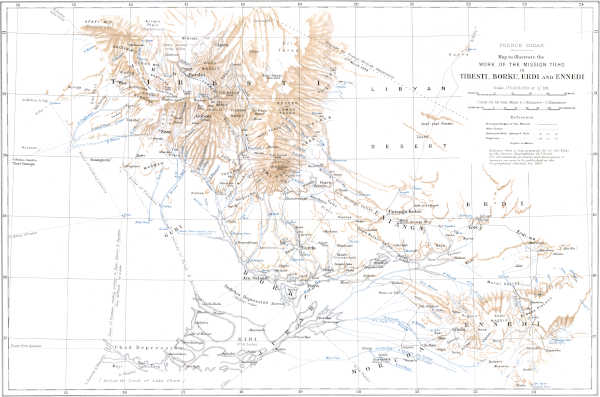
Modified Polyconic (1/M. International Map) Projection. Published by the Royal Geographical Society. TIBESTI Tilho
(Large size)