VI. (continued 3)
Reading edition
At Fréjus, the baptistery is ornamented with a granite monolithic column in each of its eight angles, provided with caps of white marble. The caps and bases (Fig. 134) are varied in design, and are all closely imitated from the Corinthian, although none of them are exactly after that pattern. The massive fragment of stone, moulded on the front, which is placed over each, is probably a survival or reminiscence of the entablature which was always thought necessary in classic times. The upper portion, which was most likely an octagonal dome in the original building, is now modernised. The plan shews an attempt to make the floor as square as possible, by means of four deep niches introduced in the four angles. The central font is peculiar in form, and stands on a fragment of an ancient column.
In connection with this baptistery it may be interesting here to call attention to the fact that a monument in the same style, but superior in size and design, still exists at
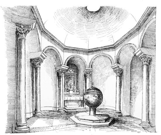
FIG. 134. FRÉJUS CATHEDRAL, BAPTISTERY.
Riez, an ancient Roman colony instituted under the patronage of Augustus, some distance to the north-west of Draguinon. The original town was built on the plain watered by the river Colastre (a tributary of the Verdon), but the inhabitants have long abandoned the low ground, and the houses now stand an the slope of the Mont Saint-Maximin above. In the deserted plain are to be found four Corinthian columns of grey granite from the Esterel with caps, bases, and architraves of marble. These, according to Texier and Pullan, formed the façade of a prostyle temple.
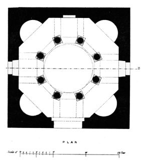
FIG. 135. THE “PANTHEON,” RIEZ (From Texier and Pullan).
The numerous fragments of pottery and mosaics which are constantly dug up, and a large quantity of portions of columns and architraves built into the modern walls, shew that the Roman works here were at one time considerable.
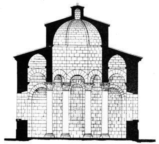
FIG. 136. THE “PANTHEON,” RIEZ (From Texier and Pullan).
In the chapel of St Maxime six Roman columns have been utilized. But the most remarkable monument of the place is the so-called “Temple” or “Pantheon.” This consists externally of a plain square structure, 37 feet each way, but internally it is octagonal in plan (Fig. 135), with four deep niches in the sides opposite the angles of the square. Within the octagon are eight columns standing detached, so as to form an aisle all round, while they support an octagonal drum (Fig. 136), roofed over with a dome. The aisle is vaulted, with an irregular form, composed of about three-fourths of a pointed arch. The columns are ancient, but they have evidently been removed from their original position, being unequal in the length of the shafts, and the size and design of the capitals, and have no doubt been collected from various sources. Texier
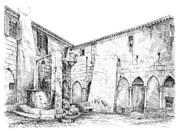
FIG. 137. FRÉJUS CATHEDRAL, CLOISTERS.
and Pullan believe that this was an ancient Roman structure converted to Christian uses in the sixth century; but excavations in the floor have revealed the remains of a large baptismal basin, similar to the original Italian ones, thus leaving no doubt as to the primitive destination of the structure. The pointed arch over the aisle is also a sign of its belonging to post-Roman times. It is certainly one of the most interesting of the early Christian edifices in Provence.
Returning to Fréjus, we observe that the cloisters, which are on the north side of the small court or lobby adjoining the baptistery, were erected at a somewhat later date than the tower, in a style strongly recalling the Italian-Gothic of Florence and Genoa, which we here meet with for the first time in our eastward progress (Fig. 137). The arcades of the cloisters are plain, and rest on coupled columns, with caps carved in the style of the Italian-Gothic of the fifteenth century, the whole being carefully and elegantly executed in white marble; and, though now sadly built up and mutilated, they still possess a wonderfully picturesque and charming effect. The coupled columns were evidently not intended to support vaulting, but to carry the unique and effective wooden roof (Fig. 138), part of which still exists, but is so greatly decayed that it has to be supported with rough props and wedges. At a still later period the entrance front of the cathedral has been altered and finished in its present ungainly form (Fig. 133). The floor of the cathedral, owing to the slope of the ground, is several feet below the present level outside, and has to be approached by descending steps. Originally the entrance to the narthex was no doubt on the level of the cathedral floor. The outside level has apparently, however, been heightened before the present entrance doorway was built, as it
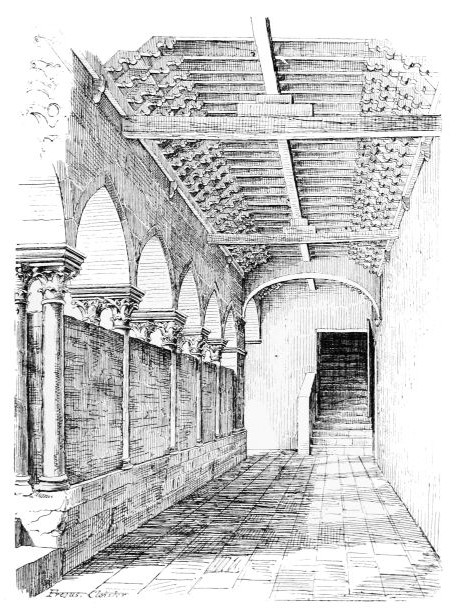
FIG. 138. FRÉJUS CATHEDRAL, CLOISTERS.
conforms to the level of the “place” on the south of the church. The late Gothic style of this doorway, in which Renaissance details are mixed with Gothic forms, belongs to the sixteenth century. The wall adjoining has been rebuilt and heightened at the same date, and an attempt has been made to bring the whole façade into a symmetrically balanced design, in accordance with one of the leading principles of the classic style then beginning to be revived. The wooden doors are beautifully carved with Scripture subjects mingled with Gothic details.
This building is a specimen of the imperfect and fragmentary manner in which the Northern Gothic style was employed in Provence. We have here also an example (and we shall meet with more frequent instances as we proceed eastwards) of the spread of the Italian-Gothic style beyond its ordinarily understood boundary. But as all the country between Genoa and Toulon was for long either under the sway of Genoa or of the Grimaldi of Monaco, it is only natural to find traces of Italian taste in the Riviera, which indeed is in all respects far more Italian than French.
Fig. 139 shews an ancient lamp of brass work suspended in the centre of the cathedral.
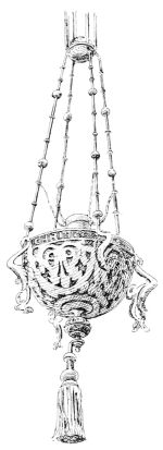
FIG. 139.
BRASS LAMP IN FRÉJUS CATHEDRAL
(From a Drawing by Mr R. Burns Begg).
The houses in the town of Fréjus possess many quaint bits of architectural detail, amongst which the woodwork of the old doorways may be specially mentioned (Fig. 140). Similar telling and original specimens of wood and iron work, it may be remarked, are not uncommon throughout the Riviera.
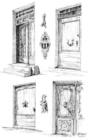
FIG. 140. DOORWAYS IN FRÉJUS
St Raphaël, a small town a few miles to the eastward, now forms the port of Fréjus. The mountainous district of “Les Maures,” which lies along the coast between Toulon and Fréjus, may either be visited from Hyères on the west (by diligence), or from St Raphaël on the east (by steamer). The latter mode forms a long but very pleasant day’s excursion. A small trading steamer leaves St Raphaël on certain days (mentioned in the “Indicateur”) at 8.30 a.m., and reaches St Tropez about 10.15, after a pleasant voyage round the headlands between the Gulf of Fréjus and that of Grimaud. St Tropez occupies the site of the ancient Heraclea Caccabaria, an important naval station in Roman times. The town has several times been destroyed by the Saracens and Corsairs, who in the ninth century took possession of the whole of the detached chain of mountains still called after them by the name of “Les Maures.” The sheltered gulf of Grimaud formed a fine harbour for their ships, and the port St Tropez was then a place from which a considerable trade was carried on with the African coast. In the later centuries it suffered the usual disturbances under Charles of Anjou, and in the wars of Religion.
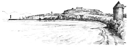
FIG. 141. ST TROPEZ.
The town still possesses some trade, and there is a fair number of coasting vessels in the harbour, to which, with their large brown sails, they give a peculiar and pleasing effect (Fig. 141). Some of the houses shew signs of having seen better days, but the whole place has a somewhat decayed and crumbling appearance. The town is surmounted by a castle, which was constructed in 1793, on the top of the hill to the south. It is surrounded with high walls loopholed for musketry and strengthened with bastions. The traffic in fish seems to be considerable, and is carried on in a dark vaulted market place, where the fish are exposed for sale, and where they are kept cooler than in the open air. The entrance to this fishy cave is somewhat picturesque (Fig. 142).
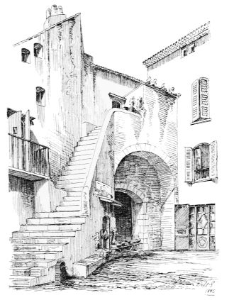
FIG. 142. ENTRANCE TO FISHMARKET, ST TROPEZ.
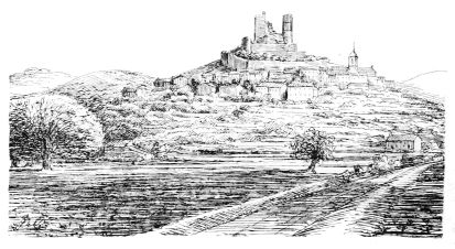
FIG. 143. GRIMAUD FROM THE PLAIN.
A daily omnibus runs from St Tropez to Cogolin at the upper end of the Gulf of Grimaud, forming a very pretty drive of an hour and a quarter. At Cogolin the road to Hyères branches off to the left, and that to Le Luc to the right. A daily diligence runs each way between Cogolin and Le Luc. There is time, after the arrival of the omnibus from St Tropez, to walk on to Grimaud and wait for the diligence there. In crossing the plain the towering ruins of the castle, crowning a lofty pyramidal hill, are seen rising about two miles off, and give promise of a splendid subject. From the base of the hill (Fig. 143) the white houses of the town clustering round the grey walls of the castle have a commanding appearance, and even when seen close they form some fine and picturesque combinations. But from an architectural point of view the castle is disappointing, being reduced to a mere skeleton of two towers, connected by a ruined wall of enceinte (Fig. 144). It was built in the fifteenth century by Italian architects for the Grimaldi, to whom this country then belonged, and it was occupied till the middle of last century.
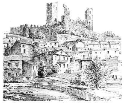
FIG. 144. CASTLE OF GRIMAUD.
Many of the houses of the town are new, but there are also some very old and picturesque streets, bordered with rude arcades. The church, though modernised, has retained its old tunnel vault, with transverse ribs, and simple Provençal mouldings. It has also a semi-circular apse, and a round arched door, with very deep voussoirs, like that of Hyères—possibly a survival of the art of the Moors.
The diligence passes here at 2 P.M., and reaches Le Luc about 4.30, after a very fine drive through a mountainous country, covered with noble old forest trees. These consist chiefly of chestnuts and cork oaks, which have grown to a great size, the latter furnishing the materials for the chief industry of the country. The road consists of a long hill up to the Col or pass, on which stands La Garde Freinet, and then a long descent down to the plain of the Argens. La Garde Freinet is a small town occupying the site of the famous Fraxinet, or chief citadel of the Moors, which gave its name to all their other settlements in Provence. The Moors took possession of this lofty district in the ninth century, and from it, as a secure centre, they made their predatory descents on the surrounding fertile plains. But in 973, after a severe struggle, they were driven out by a combination of the Christian inhabitants of Provence.
The ancient Fraxinet stood on the summit of a perpendicular rock to the north of the village; but there are almost no vestiges left of the fortress, save a square cistern for water. The town, as seen from the descent on the north side, with its background of precipitous rocks and the deep wooded valley in front, presents one of the most striking and remarkable pictures in this singular locality. The drive down to Le Luc is delightful; the pine woods and rocky glens recalling the peculiar scenery characteristic of our Scottish Highlands.
After passing St Raphaël, the railway has to cut its way through the rocky promontories which here terminate the Esterel range, and jut boldly out into the Mediterranean. In alternate tunnels and viaducts it sweeps round the Cap Roux, passing, on its way, the lovely bay of Agay, and the wonderfully coloured rock masses of the red porphyritic mountains, which contrast so admirably with the rich green pine woods filling the ravines which furrow the hillsides. These mountains were quarried by the Romans, and furnished them with supplies of red and blue porphyry for the adornment of their buildings. They are
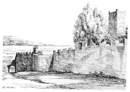
FIG. 145. CASTLE OF NAPOULE.
still worked, and yield a considerable quantity of hard materials used for street paving. On rounding the point of the Cap Roux, the wide and beautiful bay of Cannes opens to view, with its long range of white villas, backed by the dark pine-covered hills, beyond which the snowy peaks of the Basses Alpes are visible in the distance. The prominent mass of the Mont du Chevalier marks the centre, while the picture is bounded on the left by the valley of the Siagne, and on the right by the Iles de Lérins, with the Castle of St Honorat rising boldly from the sea on the furthest point. In the hollow of the bay, near the mouth of the Siagne, and commanding a fine view of Cannes, stands the ancient Castle of Napoule (Fig. 145), where some fragments of old work still survive; but a new château occupies the principal portion of the old site. Two of the original square towers are in fair preservation, and, together with the chapel and crenellated walls, form an interesting group (Fig. 146). The style seems to have been partly that of the castellated buildings of Italy, with V-shaped merlons between the embrasures, while the voussoirs of the arches are of the deep form observed at Grimaud and Hyères.
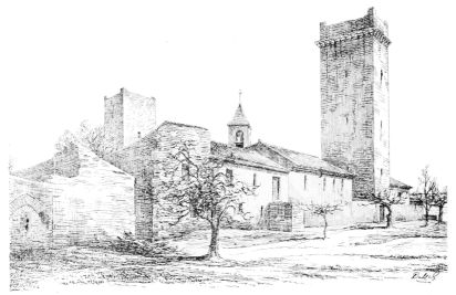
FIG. 146. CASTLE OF NAPOULE.
Napoule is supposed to have been a Roman port, having a depôt for grain connected with it. The castle was built by the Counts of Villeneuve in the fourteenth century. It belonged to that branch of the family called Villeneuve Franc, and afterwards to the family of Montgrand.
Close to Napoule rises the conical hill of St Peyré, on the top of which are the scanty ruins of a castle and a chapel with an apse. At the base of the hill, and close to the public road, may be seen the remains of another apsidal chapel. Beyond this various branches of the Siagne are crossed, when a small conical hill crowned with
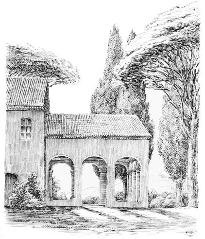
FIG. 147. MONT ST CASSIEN.
wood rises abruptly on the left, to which the distant towers of Grasse and Mougin, with the mountains beyond, form a background. This hill is the Mont St Cassien, where a famous hermitage existed, and where a great popular festival is still held annually on the 23rd of July. An entrenched post was formed here under the Romans, for the defence of the Aurelian Way. On this spot was also erected a Temple of Venus surrounded with a sacred grove called the Ara Luci (hence the modern Arluc, a small town in the vicinity). In the seventh century this heathen temple was demolished by the religious of the Lérins, and a convent erected instead, which, in its turn, was destroyed by the Saracens. A chapel with an open arcaded porch now marks the spot (Fig. 147), which, surrounded as it is with ancient cypresses and pines, is one of the best designed structures of the kind in the district. Small open-air chapels or shrines of this description, with arcaded porches, are very common all over the Riviera, and often form very pleasing objects in the landscape, occupying, as they frequently do, somewhat prominent sites. They are almost invariably in a late Renaissance style of architecture.
Cannes is the one of the health resorts which has perhaps made the greatest progress within the last fifty years, having developed from the small fishing village which Lord Brougham found it in 1831, when he erected the first English villa, into a town of fine residences and splendid hotels extending for about four miles along the coast, and rising on the wooded hills, or nestling in the sheltered ravines which seam their flanks.
Like most of the towns on the Riviera, Cannes owed its first existence to a rocky eminence in the middle of a bay, forming at once a naturally sheltered harbour and a suitable site for a fortification for its defence (Fig. 148). It is therefore probably a place of very ancient origin, and was in all likelihood the primitive Ligurian settlement of Ægitna, where the Roman Consul Quintus Opimius obtained a victory over the Ligurian tribes B.C. 155. The town was then handed over to the Massiliotes, the allies of the Romans, and went by the name of Castrum
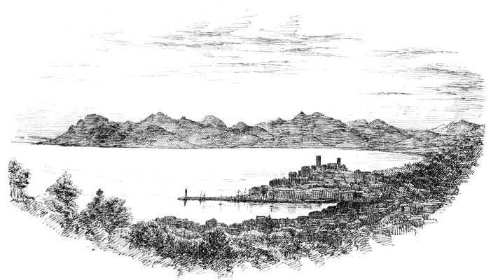
FIG. 148. BAY OF CANNES AND THE ESTERELLE MOUNTAINS.
Massiliorum during the Middle Ages. Sometime before the tenth century it became a fief of the powerful Abbey of the Lérins, to which the whole of the adjacent country had gradually become subject. The ecclesiastical suzerain was represented on the mainland by a “chevalier,” who occupied the castle of Cannes, which crowned the rock above referred to, and was surrounded with walls. On the slopes of the castle hill and round the harbour at its base were erected the houses of the ancient town, and in the same position still stand the dwellings of the native population, approached by steep and narrow alleys (Fig. 149).
The summit of the hill is crowned with the only buildings in Cannes having any claim to antiquity. These consist of the “Tour du Chevalier,” the ancient Church of St Anne (formerly the chapel of the castle), and the more modern parish church of the seventeenth century, the whole being surrounded with the remains of walls, towers, and bastions of various periods, enclosing open spaces and courtyards, and presenting a very varied and picturesque ensemble.
The “Tour du Chevalier” (Fig. 150) is a structure of peculiar interest, being the first we have met with of a series of similar towers which, we shall find as we proceed, were erected in the eleventh and twelfth centuries for the defence of the towns and churches of this district. These towers are generally, like that at Cannes, square on plan (Fig. 151), and have walls built with courses of square dressed stones, having the faces left rough. The ground floor is vaulted, and is entered only from the first floor by an aperture in the vault. The entrance doorway to the tower is on the first floor, at a considerable height above the ground; being so placed for security and being only approachable by a moveable ladder. The projecting step
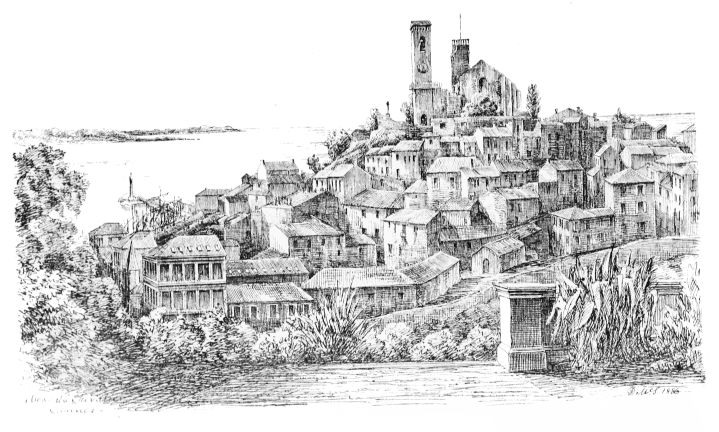
FIG. 149. THE OLD TOWN OF CANNES.
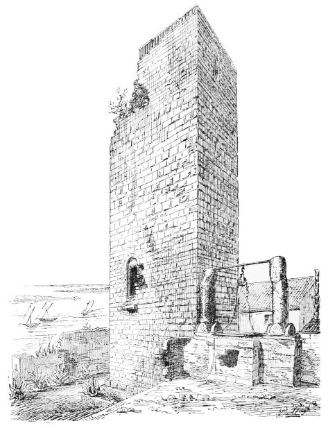
FIG. 150. TOUR DU CHEVALIER, CANNES.
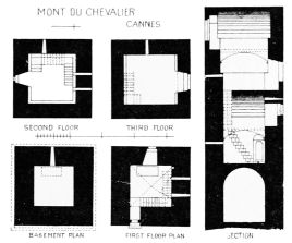
FIG. 151. PLAN AND SECTION OF THE “TOUR DU CHEVALIER,” CANNES.
to receive the top of the ladder is visible in the Tour du Chevalier, beneath the entrance door. The latter has a straight lintel recessed within a plain round arched opening. From the first floor level a stone stair corbelled out from the interior of the wall and running round the sides of the apartments led to the upper floors, which were originally formed of timber, although now vaulted with flat arches of more recent construction, probably of the sixteenth century. The roof was no doubt flat and was provided with a crenellated parapet, projected on corbels with machicolations between them. This parapet was only destroyed some years ago, when the tower was struck by lightning. The openings for light are small square apertures in the masonry without splay or ornament. They have no internal bay, but are mere oblong holes passing through the walls. These holes might almost be supposed to have been used for projecting beams through, on which to rest wooden hoardings for defence, but there are no doors for access to such works. According to the Abbé Allier, in his History of the “Iles de Lérins,” this tower was begun in 1073 by the Abbé Aldebert II., partly on Roman substructures. The parapet was, however, not completed till 1395 by the Abbé Jean de Thornafort. This tower and the other similar towers of this district (of which more hereafter) occupied in their design an intermediate position between the keeps of the North, such as that of Montmajour, and the lofty towers of the Italian cities, of which those of Sienna and Verona are well known examples. The courtyard of the castle was enclosed with walls fortified with towers, of which some portions still remain, but the enceinte has been greatly altered in later times, and converted into bastions with platforms for guns, and parapets loopholed for musketry. This was probably done during the Spanish wars of the sixteenth century. Within the walls there were no doubt buildings for the residence of the Chevalier and the garrison, the tower being only used for watching, and as a keep or last resort in case of siege. Of the original structures the only one besides the tower now remaining is the church of St Anne, which, according to the Abbé Allier, was erected towards the end of the twelfth century. This church forms an example of the simple style of Cistertian architecture, which, as already remarked, was largely adopted in Provence—especially, as we shall see, in many of the smaller churches. In these we find the Cistertian plainness combined with the plan of a simple nave without aisles, terminated with an apse at the east end.
The Church of St Anne (Fig. 152), although erected in connection with the castle, also served originally as the Town Church. It is of the same simple type as Thoronet, but on a much smaller scale. The plan (Fig. 153) consists of one long nave, 87 feet in length by 20 feet wide, with a round apse at the east end; and it has no aisles
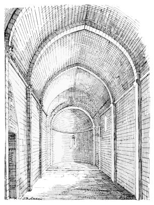
FIG. 152. CHURCH OF ST ANNE.
or transept. The walls are perfectly plain, both internally and externally, and the roof is constructed with a pointed vault, strengthened with square transverse ribs, which spring from simple pilasters in the wall. The cornice between the wall head and the arch consists of the same plain ovalo moulding as at Thoronet, and the part of it forming the impost of the transverse ribs is “cut off” at the sides, like the impost of the cloister arches at that abbey. Some of these imposts, adjoining the central door, have a few rude and scarcely intelligible carvings on them—apparently
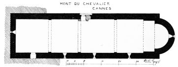
FIG. 153. PLAN OF ST ANNE.
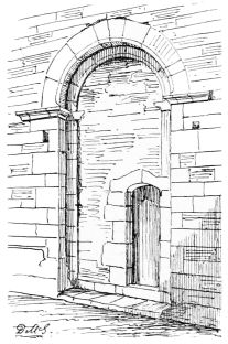
FIG. 154. DOORWAY OF ST ANNE.
of human heads. The apse is semi-circular, with a very short choir raised one step, and covered with a semi-dome as at Thoronet, but there is no round window above the choir arch. The original doorway (Fig. 154) enters from the north side, where, probably, the outer bailey of the castle was situated. It is composed of a simple outer and inner round arch, forming one nook. The impost is a plain cavetto, the portion supporting the inner arch being “cut off” at the sides. The doorway is 5 feet wide; but, in later times, this was found too large, and it has been partly built up and reduced. It was probably placed near the centre of the church, and made of the above width for the convenience of the town’s people. There is a door in the west bay of the chapel, placed on a high level, which may have been used for access from the castle to a gallery or upper floor, such as was frequently introduced in similar castle chapels.
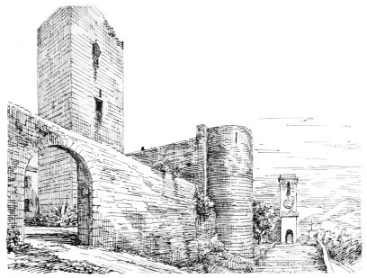
FIG. 155. MONT DU CHEVALIER, CANNES.
At a comparatively recent date the walls of the chapel have been raised (Fig. 155), and the top of its vault used to form a platform for guns, to aid in the defence of the town and castle.
The existing parish Church of Notre Dame d’Espérance occupies a prominent position on the Mont du Chevalier. It is a heavy building of the eighteenth century. The only redeeming feature it possesses is the west doorway (Fig. 156), which is a good example of the Renaissance work of the seventeenth century. The tower at the north-east angle of the church (seen in the above view) has been raised in comparatively recent times on the substructure of one of the original towers of the castle. The lower portion with its round archway is certainly ancient. The upper part, which is now the clock tower of the town, forms a prominent and telling feature in all the views of Cannes.
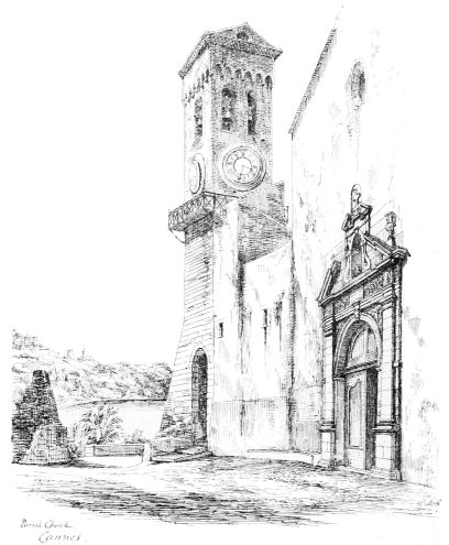
FIG. 156. NOTRE DAME D’ESPÉRENCE, CANNES.
In the bay, opposite Cannes, lie the two Iles de Lérins, dedicated respectively to Ste Marguérite and St Honorat.
Architecturally speaking, the Island of St Honorat possesses the most interesting series of buildings in the Riviera, combining, as it does, some features of the architecture of every period and style of Provençal art, whether Ecclesiastical or Civil.
This island, which is the outer and smaller of the two, held, for some centuries, an important and honourable position in the West of Europe. It was originally occupied as a post by the Romans, the materials of whose buildings, in the form of broken bricks, etc., are scattered over the soil. We shall also find that some Roman columns have been preserved and utilised in the castle, while numerous Latin inscriptions may be seen built into the walls of the modern cloisters. In the fifth century the island seems to have been deserted when St Honorat retired to it, and there founded a monastery, which was destined to become famous. It constituted for long the chief repository of all the learning and education which remained in Southern Gaul; and, like Iona, became a centre from which missionaries issued to enlighten the surrounding countries, and spread religion amongst the Barbarians. Besides many other celebrities, St Patrick, the patron saint of Ireland, is said to have been educated here.
A monastery was erected in the centre of the little island, which is only about half-a-mile in length. Some remains of a church of the eleventh century were still extant in 1836, when Mérimée visited the island. It was a simple basilica, having a nave of six bays, covered with a pointed barrel vault, and side aisles with abutting vaults, like Thoronet.
But, in 1876, these remains were swept away, and a new church erected in the Provençal style, but without any special features. The only ancient portion now remaining is the cloister (Fig. 157), built in the simple Cistertian style, with a circular vault, strengthened with transverse ribs. The side next the cloister garth is enclosed with a wall, in which only small openings or windows are perforated—not the usual wide arcade.
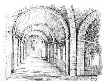
FIG. 157. CLOISTERS, ST HONORAT.
Of the antique structures of the island an extremely interesting example still survives in the chapel of the Ste Trinité (Fig. 158), situated at the eastern point of the island, opposite the islet of Ferreol. It is very peculiar in design, and is undoubtedly one of the earliest buildings in Provence.
The plan (Fig. 159) shews a nave of two bays, having one transverse arch supported on simple columns, with rude caps of the same section as the string courses or imposts of the arches, beyond which is a triapsal choir, crowned with a small and rudely-formed dome. The apses have their semi-domed vaults fairly well constructed, but the central dome is not raised from any definite pendentives,
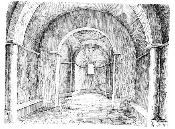
FIG. 158. STE TRINITÉ, ST HONORAT.
but as best it could be done by the workmen of the time out of a lower dome which fills in the angles between the apses.
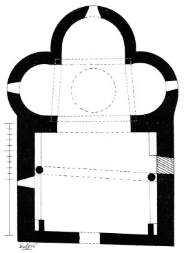
FIG. 159. PLAN OF STE TRINITÉ.
The original exterior (Figs. 160 and 161) is extremely plain, the quoins and doorway with its square lintel being constructed with large stones, probably derived from a Roman building (Fig. 162). The upper part of the walls was raised by the Spaniards, in the sixteenth century, to form a platform for guns. The earlier form of the western gable is visible in Fig. 160.
We have evidently, in this primitive structure, a rude attempt to imitate the triapsal and domical forms originally used in the early Christian architecture of the cemeteries at Rome, and afterwards more fully developed in the East. Viollet-le-Duc attributes its erection to the seventh or eighth century.
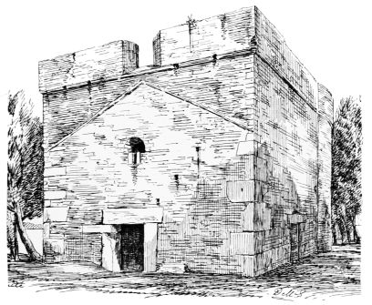
FIG. 160. WEST END OF STE TRINITÉ.
Of the seven chapels which once extended round the island, and formed the object of many pilgrimages, those of Ste Trinité (just described), and St Sauveur near the centre of the north side, alone survive. The latter (Fig. 163) is octagonal on plan, with niches on each of the sides, and a larger central one, forming an apse opposite the door. This apse alone is visible on the outside. The chapel is unfortunately greatly modernised.
In course of time the monastery naturally became rich, and formed a tempting bait to the Corsairs of the Mediterranean, whether Saracen or Christian, who attacked and plundered it several times. It is said that on the occasion of one of these descents in 725 St Porchaire and five hundred monks were massacred. A restored chapel to the south of the convent still bears the name of that martyr.
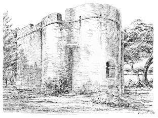
FIG. 161. STE TRINITÉ, EAST END.
To provide a safe place of retreat in case of similar attacks in future it was resolved to erect a keep or castle on a promontory of rock which juts out into the sea at the south side of the island. Here a perpetual look-out could be kept over the sea from the watch-tower on the summit, and notice of danger given by ringing the bell (the belfry for which still exists) in time to enable the monks to take refuge with their valuables within the keep. The castle is stated to have been begun about 1073 by the Abbé Aldebert II., partly on Roman substructions and partly on the rock, and the chapel was consecrated in 1088 (see “Les Iles de Lérins,” by the Abbé Allier.) In fifteen years the second floor was commenced, and in 1190 the tower was finished. Having been frequently sacked and destroyed there is some difficulty in making out the original plan. Besides, containing as it does, an open cloister, it differs so greatly otherwise
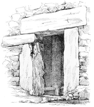
FIG. 162. DOORWAY, STE TRINITÉ.
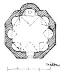
FIG. 163. ST SAUVEUR, LÉRINS
(from Révoil).
from the feudal castles of the time, that their plans give little aid in deciphering that of the monastic keep. It seems, however, to have been originally (Fig. 164) an oblong building measuring 85 feet from east to west, and 58 feet from north to south, with a wing projecting to the southwards. This block was divided into two portions by a central wall running north and south, and contained in the eastern division an open cloister, formerly three, though now reduced to two storys in height, and in the western division the refectory, dormitory, and other apartments. To the east a small projection or tower contained on the first floor the lavatory and latrines, and at the top was carried up as a watch-tower above the parapet, and
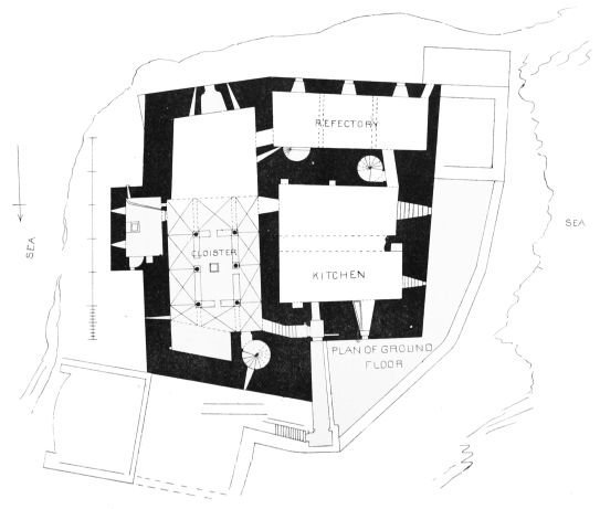
FIG. 164.
surmounted by the belfry for the alarm bell. The space at the north end of the cloister is (as we shall presently see) a
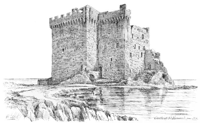
FIG 165. CASTLE OF ST HONORAT (from N.-W.)
later extension of the original keep. The entrance door is in the north wall (Fig. 165), several feet above the level of the ground. It has a square lintel, with a round saving arch over it, and the door was strengthened with a sliding bar. A narrow passage at right angles, furnished with a second door, leads by a few steps up to the level of the principal floor and opens on the cloister. This is the most striking and remarkable part of the castle. It is 40 feet long by 27 feet wide, and is surrounded with a vaulted gallery (Fig. 166), supported on six columns—three on each side—leaving open to the sky a central space of 19 feet by 10 feet. The first view of this cloister is most impressive. The ancient appearance of the granite columns, with their quaint caps and bases, surmounted by bold pointed arches, above which rises an upper and lighter arcade; the rich colour of the walls; the sombre effect of the dark arcades contrasted with the bright light of the open central court; and the unusual character of the structure, all combine to produce a powerful and lasting effect on the mind. Nor does a closer inspection diminish the interest. Some of the pillars are found to be genuine Roman ones, brought from some ancient building, and here utilised in a very matter-of-fact though telling manner. The columns being generally too short, some of them have been pieced up with the yellow limestone of the district, while others have been elevated on bases of extra height. Three of the ancient shafts are of granite, one of red marble, and the remaining two of limestone. On one of the former (that at the south-west angle) can be read part of an inscription in honour of Constantine. This shaft has the appearance of having been long exposed in the open air, and many of the letters are worn away, so that some parts of the inscription are difficult to decipher. The following is the rendering of the
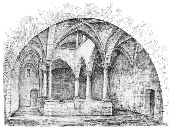
FIG. 166. LOWER CLOISTER, ST HONORAT.
Abbé Allier; the letters within brackets being, however, illegible:—
IMP [CÆS] FL VAL CONSTAN TINO PF AUG [DIVIMAX IMIANI AUG] NEPOTI DIVI CON STANT AUG [PII FILIO]
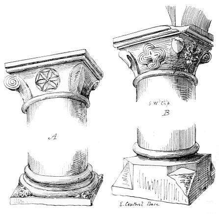
FIG. 167. CAPITALS AND BASES, CASTLE OF ST HONORAT.
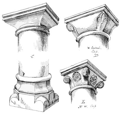
FIG. 167a. CAPITALS AND BASE, CASTLE OF ST HONORAT.
Another interesting point connected with these pillars is the form and decoration of their capitals and bases (Figs. 167 and 167^a). At first sight they look very rude and primitive, but on careful examination they are seen to possess certain characteristics which belong to a comparatively late period, thus raising a suspicion as to their antiquity, which the evidently late vaulting of the cloister tends to confirm. One is therefore somewhat puzzled how to regard them, and what date to assign to them. But a comparison of the caps and bases of St Honorat with those of the cloister of Thoronet at once removes all difficulty. Original and quaint as both are, they are evidently (with the exception of some which are later, and will be afterwards referred to) the product of the same style and period. The Abbé Allier informs us that in 1295 the Abbot Gancelme de Mayreris did much work in the interior of the tower, and in 1315 a general chapter granted certain fines in order to raise funds for its completion. To this period probably belongs the first construction of the cloister. But in 1400 the monastery was attacked by Genoese pirates, commanded by one Salageri, who took the castle by assault, imprisoned the monks, and pillaged the monastery. These Corsairs kept possession of the castle for about a year, and were only got rid of by a general muster of the nobility of Provence, with their retainers. The invaders probably greatly destroyed the building; for we learn that after 1400 the cloisters, “L’Escalier tournant,” and other works were commenced, and carried on by one Gastolius de Grasse, who died in 1422. These facts indicate two periods of considerable operations at the castle, one in the beginning of the fourteenth and the other of the fifteenth century. Some of the caps (such as A, D, and E), which so strikingly resemble those of the cloisters of Thoronet, probably belong to the first of these periods; while others (like B) have been executed in imitation of them, but contain details which are undoubtedly of the period of the later work. The capital (B) and most of the bases are clearly of the fifteenth century; the style of the ogee and other mouldings, and the foliage of the griffes or claws at the angles and on the cap B, being of a late character. The form of the vaulting (Fig. 168), with its thin groins all dying away to one sharp point at the springing, and without caps or corbels to rest on, also corresponds with that date. The cloister arches are pointed, but have no mouldings. It was in 1394, shortly before the second of the above periods, that the body of St Honorat was
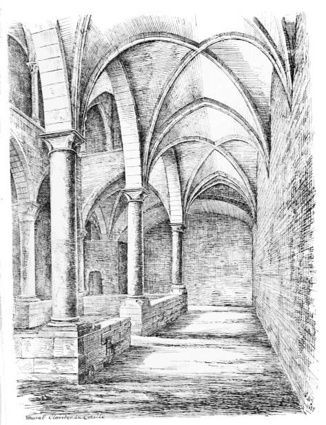
FIG. 168. LOWER CLOISTER IN CASTLE, ST HONORAT.
brought to the island from Forcalquier. Altogether, at this time the monastery seems to have been in great activity, and extensive works appear to have been then carried out at the castle. The portion adjoining the north side of the cloister was at that time extended, so as to form a projection to the northward, containing the “Escalier tournant” above mentioned. The elliptical arch of the doorway to this wheel-stair (see Fig. 166) is evidently a late work, and a wide joint or crack in the masonry, shewing the point from which the extension northward took place, can be distinctly seen in the exterior of the east wall (Fig. 169), where it extends from top to bottom of the castle. The style of the masonry of this portion is also smoother than the original work, which is left rough or “bossy” on the surface. The object of this addition has probably been to provide a space for a guard-room near the entrance to the castle with a wide staircase, and a broad platform on the roof for defensive purposes. Beneath the cloister is a large cistern or tank, stated by the Abbé Allier to have been constructed by Gastolius de Grasse early in the fifteenth century; it contains a supply of good water. A steep stair opposite the entrance door leads down to some small cellars, arranged in two storys (Fig. 170), under a portion only of the western part of the tower.
Ascending the “Escalier tournant,” the steps of which are four feet long, we arrive at the upper cloister (Fig. 171). This contains a gallery all round, with a parapet next the open court, on which stand twelve octagonal columns supporting as many pointed arches (Fig. 172). The whole is built in fine white marble, and the design is in the Italian-Gothic style, somewhat similar to that of the cloister arches at Fréjus. Some of the shafts and caps are evidently restorations in imitation of older ones (Fig. 173).
Allier states that the arms of the Grimaldi family
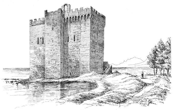
FIG. 169. CASTLE OF ST HONORAT (from N.-E.)
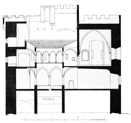
FIG. 170. CASTLE OF ST HONORAT (section from N. to S.)
could be traced on one side of this cloister, two members of that house having been Abbots commendatory of the Lérins. This probably marks the date of the restoration—fifteenth century—but the original pillars seem to be at least a century older. Some of the tiles of the floor, which are of a plain red colour and square, still remain. Although the cloister is now roofed in over the first floor, the section (see Fig. 170) indicates that there was formerly a third story. The corbels in the wall to support the beams of the roof are distinctly visible. The roof may have formed a platform nearly on the level of the battlements. The two upper floors were not vaulted, but arches were thrown across at the four angles (see Fig. 172) against the outer wall so as to strengthen and steady the whole structure. On the first floor (Fig. 171) the northern addition forms a recess, covered with a plain circular vault, and lighted by a wide window provided with stone seats. The east projection also forms a recess with a small window and a locker in the wall. This was probably the sacristy, as it adjoins the chapel in the south wing.
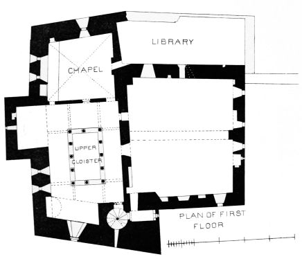
FIG. 171. CASTLE OF ST HONORAT, LÉRINS.
The southern wing or projection seems to be of the same date as the original castle, and to have formed part
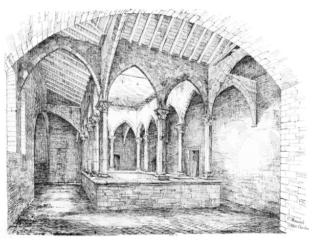
FIG. 172. UPPER CLOISTER, CASTLE OF ST HONORAT.
of it. On the ground floor it is covered with a plain semicircular tunnel vault similar in construction to that of the northern projection, but there is no indication on the exterior of there having been any extension of the masonry, such as above indicated at the northern end.
The first floor of the south wing contains the chapel, 25 feet by 26 feet with a groined vault about 28 feet high (see Fig. 170). The ribs are large and of a square section, and rest on plain corbels in the angles, the construction of the whole being very simple. The windows are small and have the same recesses deeply splayed towards the outside, as occur in the old part of the east wall in the upper cloister, and which indicate an early date.
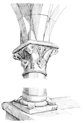
FIG. 173. UPPER CLOISTER, ST HONORAT, DETAILS.
The chapel was probably part of the original design, and was restored in the fourteenth century. We read that in 1342, the Abbot Geoffrey had the “choir” constructed in Toulon. This no doubt refers to a wooden gallery or stalls, which were then fitted up, but have now entirely disappeared.
The western portion of the castle was divided in the centre by a wall running east and west. The northern division seems to have contained the kitchen, and the other half the original refectory. The stone sink still exists in the kitchen window to the north. The windows looking to the west are small and high, the sill being stepped up. The upper floors in this wing would contain the dormitories, being provided with fireplaces and garderobes in the walls. But this part of the building was much altered in the seventeenth or eighteenth centuries, and Mérimée mentions that when he visited the Island in 1834, the place was divided up into small rooms with plaster partitions, and, he adds, “some of the chambers are still painted in the style of the eighteenth century, several of the panels over the doors representing shepherds and shepherdesses in the style of Van Loo, decorations one would scarcely look for amongst the monks.”
At a period subsequent to the original erection of the castle, the angle contained between the southern projection and the main building was enclosed with a wall and added to the structure. The walls of this addition are much thinner than the old ones, being only about 4 feet, while those of the original castle are from 8 to 10 feet thick. That this portion is an addition is evident from the style of the masonry of the old southern wall, which is visible in the interior of the extension, and corresponds with the rough ashlar of the exterior walls generally (see Fig. 174, right side).
The principal floor of this addition, entering off the lower cloister, was used as the refectory (Fig. 174). It is 47 feet long by 16 feet wide, and is roofed with a round tunnel vault strengthened with transverse ribs. This structure must belong to a comparatively late period—probably the fifteenth century—but it is noteworthy that the old Provençal style of tunnel vaulting, strengthened with transverse ribs, having a simple ovalo for the string course or impost, and “cut off” corbels, is still maintained.
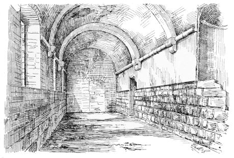
FIG. 174. REFECTORY, CASTLE OF ST HONORAT.
The custom of reading to the monks during meals by one of their number was evidently observed here, from the semi-circular recess or pulpit, raised a few steps above the floor, which is formed in the wall at the north-east angle.
The basement of this addition may have been used as cellars and stores, and was reached by a wheel stair in the thickness of the wall. The upper floor (now destroyed) was the library, which contained a large number of valuable MSS., now dispersed and lost.
At the restoration of the fifteenth century, the top of the castle on the sides next the land (Figs. 165 and 169) was crowned with a stone parapet projected on bold corbels, with wide machicolations or apertures for defence between them.
In 1524, and again in 1536, the castle was attacked and taken by the Spaniards, who, on the latter occasion, were commanded by the famous Genoese Captain Andrea Doria, on the part of Charles V. Some additional buildings were added by the Spaniards to render the castle more defensible according to the ideas of the sixteenth century. A narrow gangway only 4 to 5 feet wide was built, by which alone access could be obtained to the entrance doorway; and this was defended by a double doorway at its outer end, where also it could only be reached by a narrow stair placed at right angles. To the north of this was a ditch and drawbridge. An outer wall seems also to have enclosed the castle on the west side, and some additional buildings were erected at the south-west angle, but these have now almost entirely crumbled away.
This ancient ruin, so interesting historically and architecturally, is not less so artistically. Whether we regard the venerable aspect of the antique cloister or the rich golden colour of the exterior, contrasting so beautifully with the dark-green of the pines and the deep blue of the southern sea and sky, nothing could be more charming or delightful.
After the above dates the castle seems to have been garrisoned by the Crown of France, and was frequently taken and retaken by the Spaniards and the French. It was at this period that the Chapel of Ste Trinité was heightened, and fortified with two cannons; while, at the same time, other batteries were erected at different points round the island.
Meanwhile the monastery had dwindled away, but the monks still retained their suzerainty over Cannes, Vallauris, Napoule, and other villages on the mainland. Finally, in 1788, the number of monks had become reduced to four, when, on the request of the Bishop of Grasse, the monastery was secularised. Thereafter the island has several times changed hands, and now it is occupied by a body of Cistertian Monks, who cultivate the soil and superintend an orphanage.
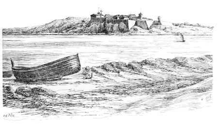
FIG. 175. CASTLE OF STE MARGUÉRITE.
The adjoining island of Ste Marguérite has but little interest architecturally. The fort, which is built on the precipitous rock on the north side of the island, facing the Croisette point at the eastern extremity of the bay of Cannes, was erected by Richelieu. Scarcely finished, it was attacked and taken by the Spaniards in 1635, who enlarged it, and after being recovered by the French, was repaired by Vauban. The view of the castle from the Croisette is picturesque and pleasing (Fig. 175); but the only point worth inspecting close at hand is the prison in which the “man with the iron mask” was confined by Louis XIV. for seventeen years. The extreme thickness of the walls (above 12 feet), the window defended by three successive gratings in the depth of the wall, the double doors covered with iron studs and secured with iron bars, give some idea of the importance of that mysterious prisoner.
In the environs of Cannes there are numerous delightful walks and excursions amongst the olives and vines of the valleys, or by footpaths over the pine-clad hills. One of the most favourite of these is to the town of Vallauris, famous for its fine pottery ware. It may be reached by a road through a rocky valley, which branches off the main road to Antibes, at Golfe Juan, or by a footpath, forming a pleasant walk of some four miles across the hills, past the wayside chapel of St Antoine, which crowns the “col” between the two valleys. From this point a splendid view is obtained over Vallauris and its surrounding hills, above which, in the distance, rise the snowy peaks of the Maritime Alps. At Vallauris there still exists an interesting architectural relic, being the original chapel of the summer palace of the Abbot of the Lérins. This residence, situated as it is amongst the hills some way inland from the sea, enjoys in summer a more temperate climate than the Island of St Honorat, which is said to be the hottest place in Provence. The property was acquired by the monastery in 1042, under a charter of Aldebert, Bishop of Antibes, and here the abbots built their seignorial castle. The chapel probably dates from the thirteenth century. The remainder of the palace was demolished in the end of the fourteenth century by a famous brigand, Raymond de Turenne, who devastated the whole coast of Provence. In the beginning of the sixteenth century one of the monks of the Lérins, Régnier de Lascaris, rebuilt the town on a regular plan, with good streets placed at right angles, presenting a very striking contrast to the network of
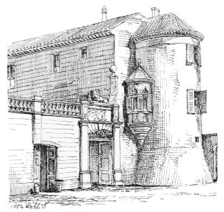
FIG. 176. ABBOT’S SUMMER PALACE, VALLAURIS.
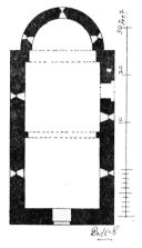
FIG. 177. CHAPEL OF ABBOT’S SUMMER PALACE, VALLAURIS.
narrow tortuous lanes which form the usual streets of Provençal towns. The houses were constructed for the accommodation of the workmen employed at the celebrated potteries of the valley, which were well known even in Roman times, and are still of world-wide fame. The palace was probably rebuilt about the same time, and possesses some picturesque features (Fig. 176). The chapel is (Fig. 177) like that of Cannes, a simple nave,
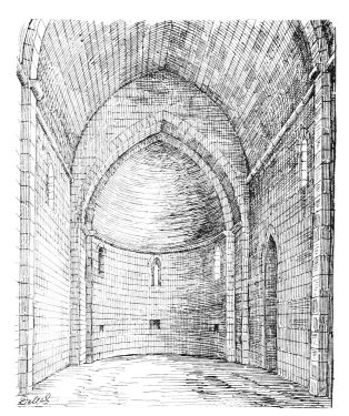
FIG. 178. CHAPEL OF ABBOT’S SUMMER PALACE, VALLAURIS.
31 feet long by 16 feet wide, with round apse about 10 feet deep. It is roofed in two bays (Fig. 178), with a pointed barrel-vault, having one square transverse rib in the centre, supported by a simple pilaster on each side, with a string course at the wall-head, and impost “cut off,” all as at the Mont du Chevalier. The apse is round, and has a pointed semi-dome instead of a round one, as at the latter. The windows are small and pointed, and have the deep external splay so common in all these buildings. There are two doors, also pointed, one of which enters at the south side from the castle court, and the other at the west end from the outside. The pointed arches in the doors and windows probably indicate a somewhat later date than the round ones of the “Mont du Chevalier.”
The chapel is now occupied as an oil mill.
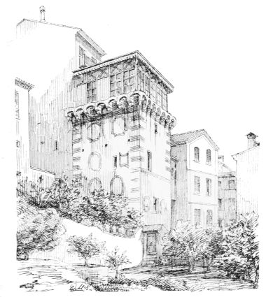
FIG. 179. “MAISON DU BRIGAND,” LE CANNET.
A wide boulevard has recently been constructed, leading from the centre of Cannes straight northwards for a distance of about two miles, through the only ground near the town which is at all level, to the village of Le Cannet. Here an ancient machicolated tower (Fig. 179), called the “Maison du brigand” (now crowned with a
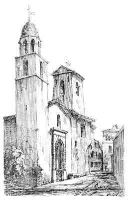
FIG. 180. NOTRE DAME DES ANGES, LE CANNET.
peaceful photographer’s studio), contrasts strangely with the new houses rapidly rising around it, along the recently constructed and improved roads; but on the higher ground some of the more antique houses and narrow lanes are still preserved near the quaint old church of Notre Dame des Anges (Fig. 180). Le Cannet forms an agreeable promenade from Cannes; and it is well worth while to continue the walk or drive northwards for about two miles through the magnificent groves of olives which here clothe the valley, as far as the base of the hill, on the summit of which stands the ancient town of Mougins. Whether viewed from below, or from the hill above on the right close by the ancient and picturesque church of Notre Dame de Vie (Fig. 181), the effect of the old town crowning its rocky and olive-clad height is always striking. The climb up the steep and many-stepped mule path to the habitations on the summit is no small task, but the labour is well repaid by the splendid
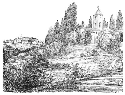
FIG. 181. NOTRE DAME DE VIE AND MOUGINS.
views thence obtained in all directions, especially towards Grasse, and by the picturesque vistas which meet the eye at every turn in the ancient narrow streets. One of the original gateways of the town (Fig. 182) is still preserved, with its machicolated parapet and the grooves for the portcullis behind its plain pointed arch. It is supposed that Mougins is the Mons Ægitna to which the native tribes retired, and where they fortified themselves after being driven from Cannes (or Ægitna) by the Romans. In returning to Cannes, the route may be delightfully varied by a walk over the hills, past Notre Dame de Vie, and along the footpath beside the aqueduct, which brings the water supply from the sources of the Siagne (some twenty miles off by road, but double the distance measured round the windings of the canal) to Cannes and Antibes.
Castellaras, about a couple of miles north from Mougins, is another splendid point of view. An ancient castle here occupies the summit of a hill, and is partly surrounded with its old wall of enceinte, but the most of the buildings connected with it are modern.
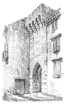
FIG. 182. MOUGINS, GATE TO TOWN.
The most important place, however, lying a few miles inland from Cannes, is Grasse, an ancient town of some celebrity, and still a place of considerable business and movement. It lies about ten miles north from Cannes, and may be approached by several roads or by railway. One road goes to the westward, by the plain of Laval and the valley of the Siagne, passing through the little town of Pégomas, and within a short distance of Auribeau (Fig. 183), an ancient city perched on the crest of a lofty hill. From this point the road steadily ascends, till, after a long climb, Grasse, which stands about 1000 feet above the sea, comes into view, its houses clustering round the old cathedral, and rising in the form of an amphitheatre (Fig. 184), tier over tier up the hillside on which it is built. From the height at which the town stands, the view over the luxuriant lower ground between it and Cannes is very commanding and delightful, the whole of the valley being laid out as gardens for the cultivation of the roses, violets, and other sweet scented flowers, from which the perfumes for which Grasse is famous are distilled.
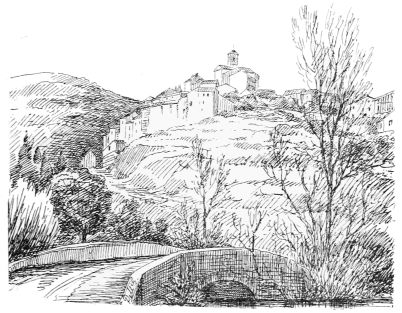
FIG. 183. AURIBEAU.
From an early time Grasse was an industrious and commercial town. It thus became rich, and its wealth brought upon it frequent attacks from the Saracens while they had their headquarters at the Great Fraxinet. Early in the twelfth century the inhabitants followed the example of the Italian towns with which they had commerce by constituting themselves a free republic. Their consuls formed treaties with Pisa and Genoa, and unfortunately the town got mixed up with Italian politics and the disputes of the Guelphs and Ghibellines. This led to the usual unhappy result of dividing the people into violent factions, and enabled Raymond Béranger, Count of Provence, in 1226, under pretext of aiding the Guelph party, to render himself master of the town. In the sixteenth century Grasse shared the unhappy fate of the rest of this part of France, when Francis I. found himself unable to defend it against Charles V., and therefore laid the whole country waste. The town also suffered greatly during the religious wars of the seventeenth century.
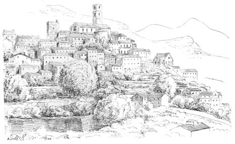
FIG. 184. GRASSE.
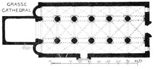
FIG. 185. PLAN OF GRASSE CATHEDRAL.
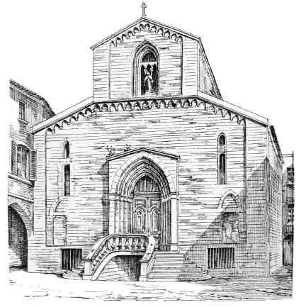
FIG. 186. GRASSE CATHEDRAL, WEST END.
The most important building in Grasse is the cathedral. It is the first church we have seen, on our way eastwards, which represents a type essentially different from that of Provence, and markedly akin to the architecture of Italy—a characteristic which we shall find more and more strongly developed in our progress along the Riviera. The plan (Fig. 185), like that of most of the churches of Italy, consists of a central nave and side aisles, all originally terminated with eastern apses, the
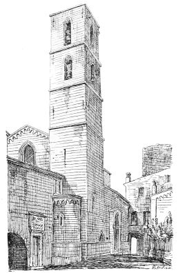
FIG. 187. GRASSE CATHEDRAL (Campanile at N.E. angle).
existing choir, which is square, being a late addition. The character of the exterior is essentially Italian (Fig. 186), being similar in its forms and ornament to the churches of Pisa and Genoa, with which towns, as above-mentioned, Grasse had commercial relations. The arcaded ornament at the eaves is very Lombardic, and the doorways of the west front and north side (Fig. 187) are of the ordinary Italian design of the thirteenth century, with low pitched roof. The tall and simple square campanile is also Italian in conception. The design of the interior (Fig. 188) is somewhat remarkable, the massive circular piers with their cushion caps having more of the character of a Northern than of a Southern edifice. They remind one, however, of those of Carcassonne. The solid square groins of the vault, springing from very simple corbels, are of a usual Provençal form—such, for instance, as those of Fréjus Cathedral. Close to the cathedral stands one of the square towers (Fig. 189), similar to that of the Mont du Chevalier at Cannes, which we have noticed as being common in the towns of this
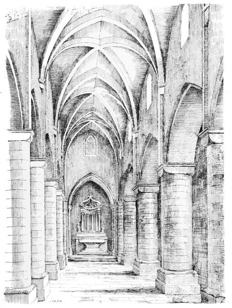
FIG. 188. GRASSE CATHEDRAL.
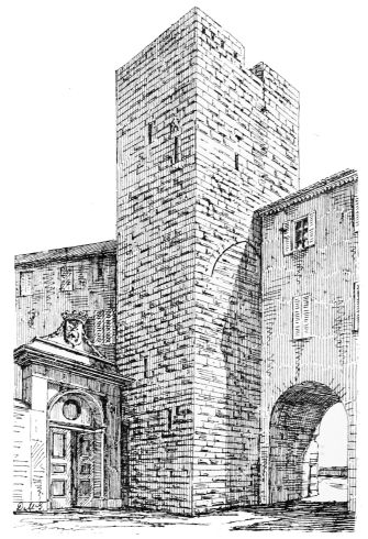
FIG. 189. KEEP TOWER, GRASSE.
province. It is built with the usual rough-faced ashlar work, but its other distinctive features are now lost, the interior being occupied as dwelling-rooms. This tower adjoins the ancient Bishop’s Palace, now the Municipal Buildings. Near this—and, indeed, scattered everywhere through the narrow and busy streets of Grasse—are
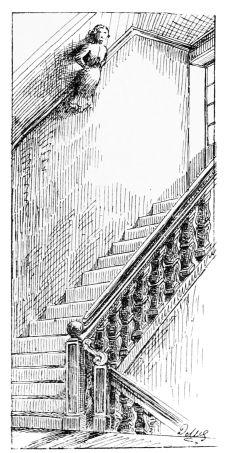
FIG. 190. STAIRCASE, GRASSE.
to be seen many fragments of the massive architecture of its ancient palaces. These are easily distinguished from their being built with the same rough-faced, solid masonry as the tower; and they often still retain a door or window of pointed form, recalling the older palaces occasionally found in the similar crowded lanes of Genoa. There are also some examples in Grasse of the great houses of the merchant princes of the Renaissance period, so distinctive of the Italian cities. The picturesque staircase of one of these is still preserved (Fig. 190). This building stands at the east end of one of the charming open “places,” surrounded with arcades, planted with trees, and enlivened with fountains, in which Grasse abounds, and which form such attractive subjects for the artist. In one of the narrow streets stands the Church of the “Oratoire,” (Fig. 191), the strikingly Italian façade of which at once arrests attention. It is evidently a building of the fifteenth century, and is exactly such a design as may be found in any of the cities of Northern Italy. The annexed sketch (Fig. 192) of one of the caps of the main piers is suggestive, and corresponds with similar details of the same period in Italy.
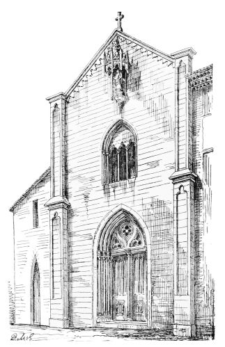
FIG. 191. CHURCH OF THE ORATOIRE, GRASSE.
From Grasse several very interesting excursions may be made, and a number of ancient buildings investigated. A very fine, although a long day’s expedition, is the drive to St Césaire and Callian. The former is reached by a side road, which branches off the main road to Draguignon, about six miles west of Grasse, and after a climb of three miles further up amongst the mountains finally arrives at St Césaire, beyond which all progress westwards is stopped on the crest of the great cliffs which hem in the gorge of the Siagne.
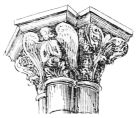
FIG. 192.
FROM L’ORATOIRE, GRASSE.
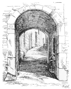
FIG. 193. ST CÉSAIRE, ANCIENT GATEWAY.
It is therefore necessary to return to the main road, itself sufficiently winding and romantic, along which a further course of eight to nine miles conducts to Montauroux and Callian. The whole journey there and back to Grasse thus extends to about thirty-seven miles, but can easily be accomplished in one day with a pair of the hardy ponies of the country.
The main road from Grasse descends by numerous wide loops towards the valley, and skirts the lofty mountains on the right, where several picturesque looking villages are seen clustering on the hillsides.
At Tignet the ruins of an ancient commandery of the templars are passed, but there is nothing of architectural interest sufficient to detain the traveller till St Césaire, amongst its remote and snow-clad hills, is reached.
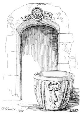
FIG. 194. AT ST CÉSAIRE.
The town of St Césaire is charmingly situated about nine miles west from Grasse. It stands on the edge of a lofty precipice overlooking the valley of the Siagne, which is here full of remarkable scenery and interesting grottoes and fountains, forming a romantic region, from which starts the aqueduct which supplies fresh water to Cannes and Antibes. St Césaire possesses still some remains of its ancient walls and gates (Fig. 193), some quaint pieces of carving over doorways etc. (Fig. 194). But its most interesting feature architecturally, is the ancient church which stands in its quiet churchyard outside the town, relieved against a background of snowy mountains (Fig. 195). It is similar in its Cistertian simplicity to those of Cannes and Vallauris, and differs only in having, instead of plain pilasters, rounded vaulting shafts, with simple caps and bases (Fig. 196), the former very similar to those of Thoronet. The church is 45 feet long by 20 wide (Fig. 197), divided into three bays, with apse 9 feet deep to the eastward. As at Vallauris there are two doors, one at the west end and one in the south side, the latter pointed externally and round internally. The windows have round arches, with the usual deep external splay, at the inner edge of which the opening is narrowed by two half roll mouldings, probably with a view to prevent draughts in this lofty and exposed region. For the same reason there are only three very small windows, two on the south side and one in the apse.
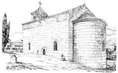
FIG. 195. CHURCH OF ST CÉSAIRE.
This church probably dates from the early part of the thirteenth century. Both the exterior and the interior are well preserved. The walls have been heightened at a later date, but why is not clear. As the alteration does not affect the interior, it has probably been done to make the slope of the roof harmonise with the west front, which has been altered and a belfry added.
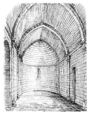
FIG. 196. CHURCH OF ST CÉSAIRE.
As in all the churches of the style, the tiles of the roof rest directly on the outside of the arches.
An ancient carved front (shewn in Fig. 194) is lying outside the church.
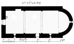
FIG. 197. PLAN OF CHURCH, ST Césaire.
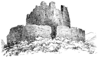
FIG. 198. CHÂTEAU DE TOURNON, NEAR ST CÉSAIRE.
The main road, from the point where the branch to St Césaire leaves it, continues westwards and descends with many wide and bold sweeps till it reaches the Siagne, which it crosses at Les Veyans, and again ascends the steep and wooded valley on the opposite side. Soon the rugged ruins of the castle of Tournon (Fig. 198) are seen frowning over the pass from their rocky eminence, which can only be reached after a hard climb through the thick wood and thorny heath which clothe the hillside. But that trouble is rewarded by the discovery of a rude and remarkable edifice. This consists of a Keep of semi-circular form built on the edge of a precipice which forms the diameter of the circle, and has apparently been considered a sufficient defence of the structure on that side. A semi-circular lofty wall of enceinte surrounds the keep on the side next the hill. The entrance gateway was doubtless in this wall where there is now a ruinous gap. The building is reduced to bare and shattered walls, so that its interior arrangements cannot be determined, but it must have been a very singular and unique structure.
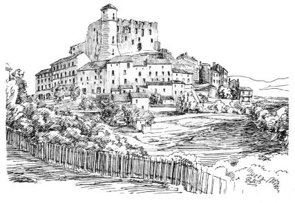
FIG. 199. TOWN AND CASTLE OF CALLIAN.
Near the highest point of the road, in continuing westwards, the village of La Colle-Noire stands across the way, and in olden times stopped all passage by means of gates in its walls. Beyond this, an open country rich in vines and olives is traversed, from which another long ascent leads to the town of Montauroux, standing on a promontory, crowned with the ruins of the Fort St Barthélemy, destroyed in 1592. A wide curve of the road, round a fine amphitheatre of terraced lands, leads from Montauroux to Callian, another little town perched on the hillside, and commanded by the immense ruins of an old castle (Fig. 199), which like all the others in the province, was sacked in 1792, and of which only the shattered shell remains. It would appear from the mullioned windows and round tower, to have been built in the fifteenth century, and has evidently been altered in the seventeenth, by the insertion of numerous large oblong openings. In the sixteenth century this pile was inhabited by Jean de Grasse.
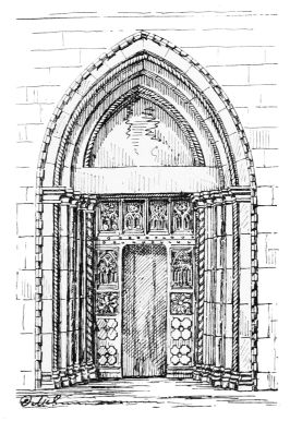
FIG. 200. LE BAR, S. DOORWAY OF CHURCH.
From Grasse another excursion of surpassing interest, not only on account of the magnificent natural scenery passed through, but also from the variety of the architectural remains, may be made to the eastward leading by Le Bar and Vence to Cagnes, where the Paris, Lyons, and Mediterranean Railway is reached. The whole distance is about twenty-five miles. The first place of note arrived at after leaving Grasse is Le Bar, about six miles to the eastward. It stands on a platform at a considerable height and enjoys a fine view to the southwards. The church, not remarkable otherwise, has a Roman inscription built into the tower, and a fine Italian Gothic doorway (Fig. 200) in the south side. This doorway, with its twisted nook shafts and arch mouldings, plain caps, and enclosing notched weather table, might have been found in almost any part of Italy. Wooden doors covered, like this one of Le Bar, with elaborate carvings, are a feature of common occurrence in every part of the province, and are often of much interest and beauty. The church contains two remarkable Mediæval paintings which were thought worthy of notice at the great Exhibition of Paris, to which they had been sent. The town is still dominated by the relics of a great castle of the Middle Ages, of which some towers remain, but it is now greatly ruined and shorn of its grandeur. Some of the old walls of the town also still survive, and give this quaint old place, perched as it is on the steep slope of the hill, an unusual and striking aspect.
From Le Bar the main road descends in wide curves towards the valley of the river Loup, but long before reaching the bottom of the gorge the eye is attracted by the unusual appearance of towers and pinnacles rising from the summit of a lofty pyramidal mountain to the northwards (Fig. 201). These distant peaks are found on nearer approach to be the edifices of the town of Gourdon, an eyrie built for security from the assaults of the Corsairs on this inaccessible and naturally fortified eminence.
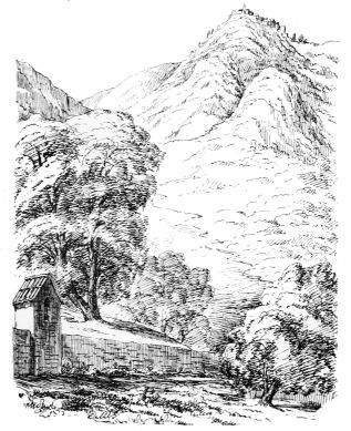
FIG. 201. GOURDON.
A post road, branching off the main road at Le Bar, passes, after many windings and ascents round the rocky sides of the opposite cliffs, within a short distance of Gourdon; but for those who intend going on to Vence, the latter course is too great a deviation from the route. Their only way of reaching Gourdon is by the steep and stony footpath which is seen rising to it in innumerable zig-zags from near the bridge over the Loup.
It is a splendid ascent, although a somewhat arduous one, and affords a lovely series of views; but it may be questioned whether one is sufficiently rewarded by the specimens of architecture which he finds in Gourdon. It is now a melancholy and deserted village, occupied apparently only by a few women and children. Some of the houses are picturesque in their grouping, like those in Fig. 202, but there is nothing fine about the place except the magnificent view to the south, east, and west from the terrace in front of the old church. One very large building seems to swamp all the rest of the little town. This is a great château (Fig. 203), built by the family of Lombard in the style of the seventeenth century, and which, we believe, is still occupied in summer, when the cool breezes of this elevated pinnacle form a grateful change from the heat of the plains.
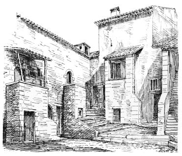
FIG. 202. HOUSES IN GOURDON.
From the point where the main road crosses the Loup, a delightful excursion may be made up the gorge amongst the mountains, as far as a famous waterfall called the “Saut du Loup.”
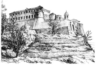
FIG. 203. CHÂTEAU, GOURDON.
The road now gradually ascends the northern side of the valley of the Loup, which is seen flowing at some distance below on the right through a richly cultivated plain. In some of the cuttings by which the road is carried round the rocks, numerous oyster and other fossil shells may be observed, characteristic of the tertiary limestone which here occurs of great thickness, and forms the immense cliffs which at some parts of the coast overhang the Mediterranean.
On approaching Tourettes the road sweeps round the abrupt side of a gorge where the rock is hollowed out into caverns, some of which are occupied as houses and stores. From this point a fine view is obtained of the grey old town of Tourettes, with its crumbling walls and houses rising from the margin of precipitous rocks of the same sad dusty colour. There seems to be nothing of special interest in the town, but outside the walls on the north side there is a wide open “place,” on which stand the Hôtel de Ville and the church of the fourteenth century. The latter is a specimen built on the plan of the simple hall without aisles. In this instance it is vaulted with groined arches (Fig. 204), the ribs having the unusual form of a plain bead, and springing from small primitive looking corbels, such as are common in Provençal churches.
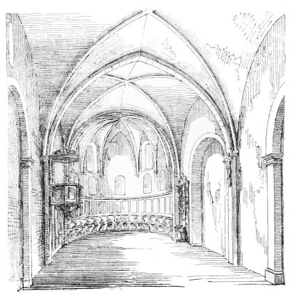
FIG. 204. CHURCH, TOURETTES.
The font (Fig. 205) in this church is of a rather remarkable design.
A few miles’ further drive through fine mountain scenery brings us to the ancient city of Vence (described further on), whence the railway station of Vence-Cagnes is about six miles distant.
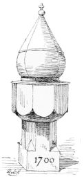
FIG. 205. FONT, TOURETTES.
We shall now return to Cannes and follow the route eastwards along the coast of the Mediterranean. This takes us first by the fine sheltered roadstead of Golfe Jouan to the city of Antibes, which stands upon a rocky peninsula jutting out into the sea, and enclosing a sheltered bay and harbour, defended on the opposite point by a great star-shaped fortification called the Fort Carré, erected by Vauban. The town itself is surrounded with walls, and strongly fortified in the style of the seventeenth century, of which it is a good and little altered specimen. The views of the town from the sea coast are charming (Fig. 206). Surrounded on the land side with its great stone ravelins and bastions, and protected on the south by its rocky seaboard, with the snowy peaks of the Maritime Alps forming a background, and the bright blue of the Mediterranean in the foreground, a finer picture can hardly be imagined.
The town of Antibes is of very ancient origin. According to M. Lenthéric, a sacred stone of the Phœnicians has here been found, with a Greek inscription, giving proof of the ancient worship of the Hellenes having been observed in this locality in the fifth century B.C. This town was also an important station under the Romans. In very early Christian times it became the see of a bishop,
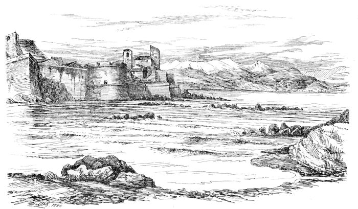
FIG. 206. ANTIBES (from W.)
but being greatly exposed to the attacks of the Saracen Corsairs, from whom it suffered severely, the see was in 1243 removed for security to Grasse. There were originally four bishoprics in this part of the Riviera, viz.:—Nice, Antibes (afterwards Grasse), Vence, and Fréjus. The whole are now comprised in the two dioceses of Nice and Fréjus.
As a frontier town Antibes was necessarily much damaged during the wars between Francis I. and Charles V., being frequently attacked and pillaged. Its ancient buildings have thus been almost entirely demolished, either by the direct effects of war or in the construction of the fortifications, so that scarcely a trace of Roman occupation remains, save in some tombs, inscriptions, and urns which have been dug up. The oldest existing structures stand on the highest point of the rock facing the sea. Here we find some parts of the cathedral of the thirteenth century, and two towers in the style of those of the Mont du Chevalier at Cannes. The church is very simple in design, and seems to have been originally similar to that of Vence, but it has been greatly altered and a new front added in the seventeenth century (Fig. 207). The two towers at Antibes are of peculiar interest. At Cannes there is only one tower or keep, which was attached to the castle of the Chevalier. At Antibes one of the towers (Fig. 208) is in connection with an old palace (now a barrack), which doubtless occupies the site of the ancient castle, being on the summit of the rock, and suitably placed for keeping a look-out seawards. The other tower is close to the cathedral (Fig. 207), and is still connected with it by a covered way on the first floor. It seems probable that the first was the keep of the temporal Commandant and the other that of the spiritual Lord. The frequent incursions of the Corsairs would render such a place of security desirable in
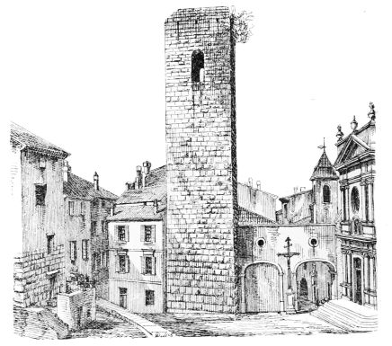
FIG. 207. TOWER OR KEEP ATTACHED TO CATHEDRAL, ANTIBES.
connection with the cathedral, and would also enable the bishop to be independent of the temporal power. Both keeps are constructed in the same manner as that of the Mont du Chevalier with rough faced ashlar blocks, and in both the entrance doorway is on the first floor. That of the castle (Fig. 208) is recessed under a plain round arch, and has a moulded step to receive the ladder or moveable stair by which it was approached. There are also two corbels, one on each side of the doorway, as if for the purpose of carrying a pent house roof. The stair is carried up round the inside of the walls and supported on corbels as at Cannes. The castle tower has in modern times been lowered and covered with a sloping roof. The bishop’s tower is now used as the belfry of the church, and has had large round headed openings cut in it near the top to let out the sound of the bells.
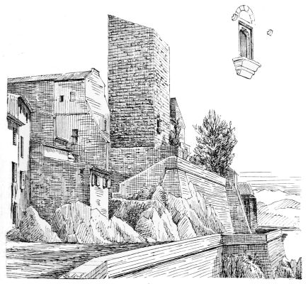
FIG. 208. TOWER OR KEEP OF THE CASTLE, ANTIBES.
On the left of this tower in the sketch (Fig. 207) may be observed some remains of similar workmanship in the masonry, which indicate the position of another ancient structure above which a modern house has been erected. Some fragments of ancient walls, and a gateway with two large round towers, may be observed on the eastern side of the Rue Aubernon, and these, together with the arcades on the opposite side, and the double row of trees which line the boulevard, form a striking and picturesque promenade. These walls doubtless enclosed the ancient cité, and the Rue Aubernon occupies the position of the original ditch. The fortifications of the existing town extend a long way beyond this ancient boundary.
In passing along the coast eastwards from Antibes a fine view is obtained on the right over the sea towards Nice, while on the other hand glimpses occur between the olive groves and up the valleys to the mountains beyond. The first of these openings, the valley of the Brague, shews the interesting old town of Biot in the distance, set as usual on a rocky height. A little further on the tower of the castle of Villeneuve-Loubet rises above the river Loup, and immediately thereafter the town of Cagnes bursts suddenly upon the view. This town consists as usual of a series of houses clustering in terraces round the sides of a detached and precipitous hill, crowned with an ancient castle on its summit. The station of Vence-Cagnes is easily reached by railway either from the direction of Nice or Cannes, and from it several pleasant excursions may be made to the places above referred to, which have just been passed, and also to the ancient towns of St Paul-du-Var and Vence, already mentioned.
Cagnes is a place of some industry, being the point of export for the products of the valleys of the Loup, the Malvan, and the Cagne. On leaving the railway station and approaching the town, the lower part of the hill on which it stands is seen to be richly clad with the dark green foliage of the orange trees, enlivened with their golden fruit, planted in stone-built terraces rising steeply one over the other up to the walls of the town.
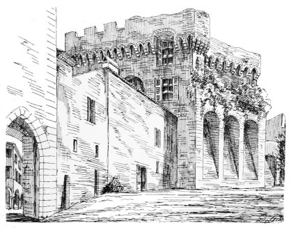
FIG. 209. CASTLE OF CAGNES (from the S.)
Entering at the south end of the hill a steep and narrow street leads straight up to the top at the north end, where stands the old castle of the Grimaldis (Fig. 209). This is evidently an ancient structure, having the bold machicolated parapet of the fourteenth and fifteenth centuries. But it has been greatly altered in the seventeenth century, when large windows have been opened in the walls, the machicolations being in numerous places cut away to receive them (Fig. 210); while at the entrance front a wide outer staircase with double ramp and marble balustrade has been introduced leading up to a principal entrance doorway on the first floor. From this access is obtained to a small inner courtyard surrounded with Renaissance columns forming a staircase and corridor above of two storys in height, which, adorned as it is with beautiful plants by the present proprietor, has a peculiarly pleasing effect. Some of the apartments are finely decorated. That of the “Belle Cheminée” has a sculptured marble fireplace and a ceiling painted with the fall of Phaeton, said to be by Carlowe. From the platform lying to the north of the château a magnificent view is obtained to the northward up the valley of the Malvan towards St Paul and Vence, and the lofty precipices of St Jeannot beyond, backed to the right with the snowy ridges of the distant Alps.
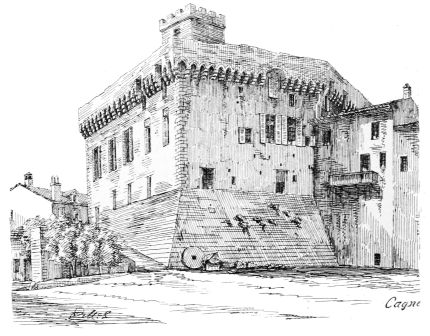
FIG. 210. CASTLE OF CAGNES (from the N.E.)
The nearest place of prominence from Cagnes is the Castle of Villeneuve-Loubet—about two miles to the north-west. This castle has been modernised and nearly rebuilt, but enough of the original work remains to render a visit very interesting. On nearing it, the edifice (Fig. 211) is seen to consist of a central castle strengthened with four towers at the angles, and surmounted by a lofty, quaint, and Moorish-looking watch-tower, the whole being enclosed with a strong wall of enceinte, defended with round towers at the angles (Fig. 212), provided with large port-holes for guns, and separated from the surrounding county by a deep ditch. The entrance gateway consists of an iron grating, guarded by two round towers, and furnished with a drawbridge over the moat. The round towers and walls of enceinte are by no means modern; they probably belong to the sixteenth century, but they have been shorn of their proud battlements, and thus present a very squat and subdued appearance.
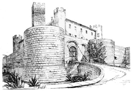
FIG. 211. CASTLE OF VILLENEUVE-LOUBET (from the N.W.)
The central castle is in part much more ancient, but also for the most part greatly altered and modernised. The
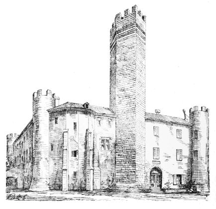
FIG. 212. CASTLE OF VILLENEUVE-LOUBET (from the S.E.)
original plan was probably not dissimilar to the existing one, comprising a central courtyard with buildings surrounding it. The exterior walls are modern, but those of the interior of the courtyard are partly ancient, although altered. They are built with the rough-faced ashlar of the thirteenth century, and contain some decayed coats of arms on which may still be traced the lances of the Villeneuves and the star of Les Baux. Externally, the east face (Fig. 212) presents two noteworthy features in the apse of the chapel and the tall watch-tower. The chapel, although now converted into apartments, still retains the outlines and buttresses of an apse which seems to belong to the fifteenth century. The watch-tower is one of the most perfect examples of those characteristic features of the Maritime Alps. It is of the same nature as the keep towers we have met with at Cannes, Grasse, and Antibes, having the same rough ashlar facing, but instead of being square on plan like them, it has the eastern side projected in the form of a sharp angle (like the tower of La Trinité in the same locality, to be described immediately, and of which a plan is given). The access to the top is by a narrow wheel-stair on the side next the quadrangle. The important point about the tower is that it preserves its battlemented top almost unaltered. It is carried up to the height of about 90 feet, and near the summit has several courses of a dark-coloured stone, which give it a Moorish or Italian character. These may at one time have been enriched with carving, of which one fancies some traces may still be observed, but they are so completely weather-worn that no forms can be distinguished. The level platform on the top is defended with a simple crenellated parapet without machicolations. From this lofty station a wide outlook could be kept over sea and land.
This castle and tower belonged in the thirteenth century to Romée de Villeneuve, the chief of that powerful family and the guardian of Beatrix, daughter of Raymond Béranger IV., the last of the Counts of Provence of that line. It was through the marriage with the heiress Beatrix that Charles of Anjou, the brother of St Louis, succeeded to the title and estates of the Count of Provence. The estate was sold at a later period to the Lascares of Ventimiglia, and is now the property of the Count of la Panisse-Pacy. In 1538 this castle entertained an illustrious guest in the person of Francis I., who stayed here while Pope Paul III. carried on negotiations between him and Charles V. The latter had landed at Villefranche in order to meet the French king; but so great was the antipathy and distrust of the two monarchs for each other, that they could not be brought to encounter a personal interview. These negotiations ended in the signature, by Francis in the Castle of Villeneuve-Loubet, of the Treaty of Nice (See “The Maritime Alps and their Sea Board.”)
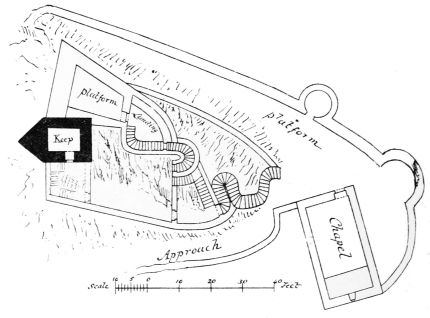
FIG. 213. TOWER OF LA TRINITÉ (Plan).
From the top of Romée de Villeneuve’s tower another similar tower is observed rising above the pine wood about a mile up the valley to the north-west. To reach it we descend from the castle so as to gain the bridge across the Loup, and in doing so the steep streets of the old town of Villeneuve, terraced in tiers on the slope of the
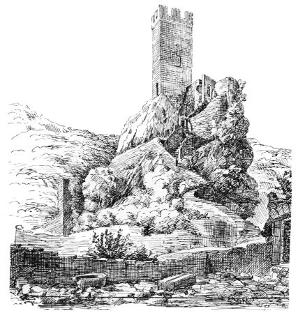
FIG. 214. TOWER OF LA TRINITÉ (from the Chapel).
hill, are traversed, and the old church on its fine platform is passed on the left. The road up the valley is easy and agreeable, but the ascent of the conical hill, the summit of which is crowned with the tower of La Trinité, is no light work. From a distance this tower looks like a lofty pedestal erected to support the colossal statue of the Virgin and child which now surmounts it. But on closer inspection it is found to be a remarkable example of a keep, defended with that accumulation of obstacles with which the old builders used to block up the access to their strongholds. After the steep hillside has been climbed, one finds himself at the base of the pointed rock on which the keep is set (Fig. 213). From here a sloping path leads up to the ruins of the chapel, of which only the vestiges of wall shewn in the sketch (Fig. 214), mingled with the scattered fragments of the font and other relics, now remain.
The ruins of a strong gateway in the outer walls which closed the access are passed just before reaching the chapel, and a lower bastioned terrace is continued round the northern part of the eminence at this level.
From the chapel, when one turns his eyes upwards to the tower (as in Fig. 214), he discovers such a series of winding stairs interrupted at frequent intervals with walls and gateways as must certainly have rendered a hostile approach in that direction impracticable, while perpendicular rocks and lofty walls made the access equally hopeless on the other sides. Besides this, on the side next the hill, which was perhaps the least invulnerable point, stands the keep (Fig. 215), strengthened with a projecting beak of similar form to that of the tower of Romée de Villeneuve. The lower story is original, and contained the doorway at the level of the top of the rock. This inaccessible point, on which there is a small platform, was probably reached by a rude stair cut in the rock (as indicated on the plan) and was defended with outworks, the approach to which was overlooked from the upper platform. The doorway, it will be observed, is placed on the opposite side of the tower from the platform, at a point where the foothold is narrow, and the door therefore all the more secure.
The upper portion of the tower dates from 1863, when, as the following inscription, which is carved on a marble slab let into the wall, announces, the old tower was reconstructed by the Comte and Comtesse de la Panisse-Pacy, and dedicated to the blessed Virgin:—
HOC ANTIQUUM CASTELLUM VULGO DICTUM LA TRINITÉ HENRICUS DE MARCK TRIPOLI COMES DE PANISSE-PASSIS ET MARIA THERESA DE ROBIN DE BARBENTANE EJUS UXOR INSTAURAVERUNT BEATÆQUE MARIAE VIRGINI IMMACULATAE TESTIMONIUM FIDEI AC PIETATIS DEDICAVERUNT ANNO DOMINI MDCCCLXIII.
The tower alone has been restored in the manner shewn by the sketches; all the other portions remain undisturbed in their ruins. The rooms in the tower are only 10 ft. 6 in. long by 7 ft. wide, and there is no indication of any other habitation connected with the fort.
The place has all the appearance of a typical robber’s stronghold, and, as James V. said of a similar Scottish keep, “He that built it was a thief in his heart.” According to tradition, La Trinité was originally a keep of the Templars. That order had extensive possessions in this part of Provence, and they may have erected this tower as a post for watching and giving notice of the approach of an enemy. After the suppression of the order La Trinité passed into the possession of the Mathurins or Redfriars. They were also called the Order of the Trinity, and their special duty was to succour prisoners. The name of the tower may possibly have been derived from them. The chapel is 29 ft. long by 14 ft. wide, and the raised step at the east end is still traceable. The
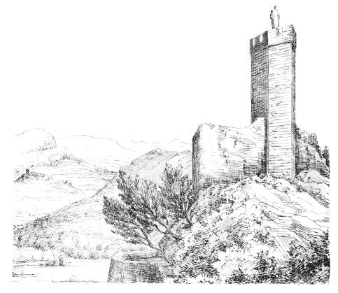
FIG. 215. TOWER OF LA TRINITÉ (from the S.W.)
walls have been about 8 ft. 6 in. high to the plain ovalo forming the string course from which sprung the semi-circular barrel vault of the roof. From the upper platform of the fortress a splendid view is obtained (Fig. 215), especially to the northwards, comprising St Paul-du-Var in the middle distance, and Vence backed by the towering precipices of St Jeannet. Beneath these stood the powerful Commandery of the Templars at St Martin (to be afterwards described), from which a signal at their watch-tower of La Trinité would be easily observed.
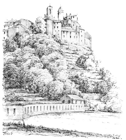
FIG. 216. BIOT.
From La Trinité a rough footpath leads across the pine-clad hills to Biot, a distance of about two and a half miles as the crow flies, but about an hour’s walk over the heath-covered heights, and through the deep ravines which have to be traversed. Some extensive quarries are passed on the way at Les Aspres. After a hot tramp over these rocky and barren hills, it is refreshing to reach the fertile and cultivated valley of the Brague with its steep and terraced banks richly clad with olive and orange trees. A very steep descent leads to the bottom of the valley, from which the walls and towers of Biot are seen rising on the crest of the hill above (Fig. 216). This is one of the most primitive old towns in the district. A very circuitous post road has now been constructed up to it, but the old accesses by long flights of wide steps, on which the peasants and their mules are constantly ascending and descending, are still preserved, and are in their way amongst the most picturesque streets in the Riviera. Climbing patiently up flight after flight, and winding round the narrow streets, we at length reach the highest point, on which stands the church. The following inscription is carved in the interior wall:—“Hanc Ecclesiam consecravit Illus, primus et reveredismus Inxpo P.D.D. Isnædus D. Grassa Episcopus Grassen,
1472 DIE 19. Janu.”

thus shewing that the church was consecrated by the bishop of Grasse at the above date. Some of the work corresponds with that period, e.g., the doorway in the west end (Fig. 217). But the south doorway (Fig. 217) has an earlier character. The exterior is all altered, and the interior has also been modernised in a very extraordinary manner, but some traces of the original building are still observable. Biot belonged to the Templars in 1247, and afterwards to the knights of Malta. In 1470 the bishop of Grasse brought hither forty-eight Genoese families, probably to help to re-people the town after the plague or some destructive assault of the Corsairs. This was evidently the occasion on which the bishop re-consecrated the church, which then no doubt required to
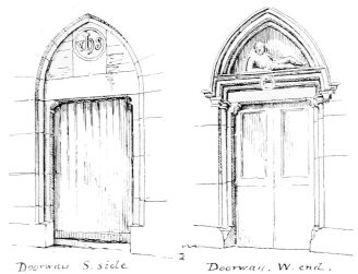
FIG. 217. CHURCH OF BIOT.
be to a great extent rebuilt. But some of it bears the signs of having been erected at an earlier date by the Templars. The plan (Fig. 218) is very unusual. A simple oblong divided into three aisles with three terminal apses such as we see here is common enough, but the plain round columns which separated the nave and aisles are very uncommon. The bases and caps are of a simple and early character (Fig. 219). The pillars are too light to have been intended to carry vaulting, and the original church would thus seem to have had a row of plain arches on each side, with perhaps a clerestory wall above supporting a wooden roof. The building would thus have originally the characteristics of a primitive basilica, somewhat like San Miniato at Florence (Fig. 33, p. 101). But this design has now been ingeniously altered and destroyed, and the whole character of the interior degraded from being one of the most interesting churches of Provence into a commonplace Renaissance chapel. By means of stucco the old round pillars have been converted on the side next the nave into flat
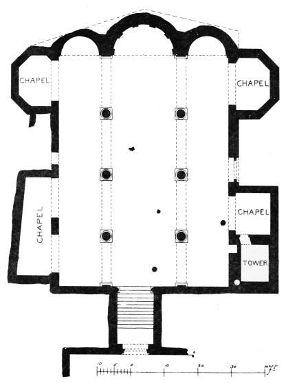
FIG. 218. PLAN OF CHURCH OF BIOT.
pilasters which are carried up and finished with Ionic caps, supporting an entablature which runs along each side of the church above the old arches. A groined vault in plaster springing from the top of the cornice is
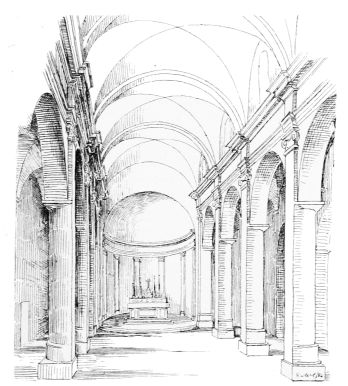
FIG. 219. CHURCH OF BIOT.
thrown across the nave. The old pillars with their caps and bases have, however, been allowed to remain unchanged on the side next the aisles, where their archaic forms contrast strikingly with the modern plaster work on the other side. An attempt has been made to Italianise the apse also, but the pilasters and entablature fit lamely into the old apse. A wide flight of steps at the west end leads down from the doorway into the church, and has a rather peculiar effect. This no doubt arose from the irregularity of the site. To the west of the church lies the public place, surrounded with plain houses, all arcaded on the ground floor, and presenting a pleasing example of that picturesque feature of the towns of the Riviera. A walk of about three miles through the olive gardens of the valley of the Brague leads to the Antibes Railway station. Biot may of course be visited directly from the latter; there is a good carriage road.
One of the most delightful excursions from Cagnes is that to St Paul-du-Var, and Vence, two of the most interesting old towns of the Riviera. The distance to St Paul is from three to four miles, and to Vence two to three miles further. This may be accomplished either by driving or on foot. A carriage may be hired near the Cagnes Railway Station. The route in driving goes by a rather circuituous road round the west side of the valley of the Malvan, passing within a short distance of the castle of Villeneuve-Loubet. The most direct road is either along the base of the hill on which Cagnes stands, or through the town. For the pedestrian the latter is by far the most agreeable. Starting from the terrace of the old castle (already described), a rough footpath is followed along the ridge which separates the valley of the Malvan from that of the Cagne, and affords a delightful prospect of both. The rich colour of the russet leaves of the forest trees, mingled with the dark green of the pines and the grey tint of the olives, gives a special charm to the walk. Looking northwards the towns of La Gaude and St Jeannet stand out prominently on their rocky heights against the lofty and precipitous mountains immediately behind them; while in the distance the white peaks of the Maritime Alps close the valley of the Var. To the south there is a splendid view of Cagnes with the Mediterranean on the horizon. After half an hour’s walk the footpath joins the main road
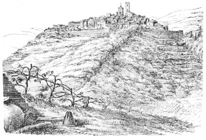
FIG. 220. ST PAUL-DU-VAR (from the E.)
opposite St Paul, and near the point where the mule path branches off to descend to the Malvan, before again ascending by a rough and steep track to the town. From the main road a fine view is obtained of St Paul (Fig. 220), surrounded with its massive walls, and standing on a detached promontory, with steep terraced slopes descending to the river. Other pleasing and varied prospects of the town and valley occur at intervals amongst the ancient olives in following the above footpath (Fig. 221). About half way up the path on the side next the town an outwork on a detached peak is passed, then a ruined fortification bars the road, and finally the ancient gateway and barbican, and the cemetery just outside the walls, are reached, and the main street of the town, which is but a narrow lane, is before us. The architectural interest of the place is at once apparent. On every hand are evidences of genuine ancient and
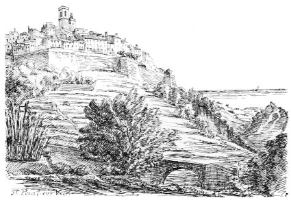
FIG. 221. ST PAUL-DU-VAR (from the W.)
unaltered work. The doorways (Fig. 222) are of old and varied forms, almost every one having a panelled lintel, supported by corbels, many of the former containing carved shields and ornaments, and the latter being enriched with leaves and scrolls. Most of these doorways are of the beginning of the sixteenth century, and indicate early Renaissance work. Others again are carved and moulded with the double curvature of the late Gothic style, and a few shew marks of a simpler and earlier design (Figs. 223 and 224). The windows also contain many specimens of Gothic shafts and mullions, but they are much more altered than the doorways. Even the ancient woodwork of the latter is in many instances retained, and the unpainted oak or walnut give, in addition to the picturesque and fanciful designs, a rich and antique character. One of the most interesting points connected with the main, and almost the only street in the town, is the preservation of its