FIRST DAY MORNING
Reading edition
THE MOUNTAIN OF RHEIMS
(See the complete Itineraries on p. 121, and the summary of the war operations on p. 131.)
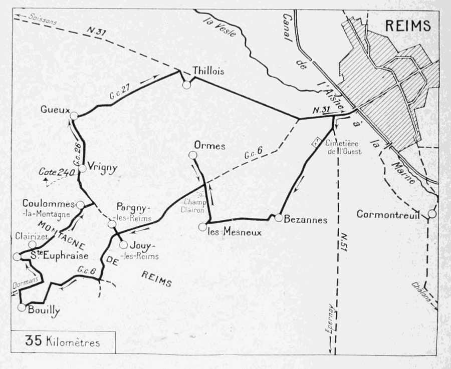
This part of the Itinerary will take the tourist to the most important points of the last German offensive of 1918, which aimed at the capture of Rheims.
Starting from the Place du Parvis Nôtre-Dame, take the Rue Libergier, opposite the Cathedral, turn to the right into the Rue Chanzy, follow same as far as the Rue de Vesle, take the latter on the left, and follow it to the end.
After the Porte de Paris (see p. 68) the Rue de Vesle becomes the Avenue de Paris. Take same, but after passing under the railway bridge, turn to the left into the Avenue d'Epernay (R. N. 51, see plan, p. 121).
Take the second street on the right (Rue de Bezannes), which passes in front of the Western Cemetery, devastated by the bombardments.
The road crosses numerous lines of trenches and boyaux, which defended the immediate approaches to Rheims.
Before reaching Bezannes village, leave on the right, two roads which skirt a large estate enclosed with railings, go straight on to the ruined railway-station of Bezannes, then turn to the right.
Bezannes
(See Itinerary, p. 122.)
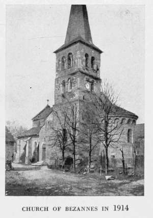
Cross the first group of half-ruined houses, then, on reaching a second group, which forms the main part of the village, turn to the left into the first street encountered, where the partially destroyed church stands.
The round-vaulted apse, tower, nave and aisles all belong to the Romanesque period. The Gothic doorway is 13th, and the spire of the belfry 15th century.
The square tower greatly resembles the old belfry on the doorway of St. Remi Church in Rheims, and, like the latter, dates apparently from the middle of the 11th century.
The Gothic doorway of the west front is set up against a Romanesque wall. The gable has been rebuilt in modern times. Vestiges of an ancient portal are to be found on each side of the doorway. The key-stones of the arch above the tympanum, like those of the upper arching, are numbered in Roman figures, a peculiarity rarely to be found.
Facing the doorway of the church, on the left of the great entrance-door to a court, is a niche containing a 16th century stone statue representing a bishop wearing a chasuble.
In the court of the same house, over the door of the main structure, on the right, in an arched Renaissance niche, hollowed out and ornamented with marble incrustations, is the statue of a canon with folded hands kneeling at the foot of a crucifixion.
A shell-splinter took off the head of the bishop's statue, but the other group is intact.
CHURCH OF BEZANNES IN 1914
Those interested in things pre-historic, may visit the Pistat Collection at Bezannes, which contains a great number of interesting specimens belonging to the stone and neolithic ages, and to the Gallic and Roman periods of the region.
Of the old castles of Bezannes, nothing of interest remains.
On September 11, 1914, during the Battle of the Marne, the German Staff took up their quarters in the house of M. Poullot. On the 12th, the battle attained the vicinity of the village.
Skirt the church, and at the cross-roads at the end of the village, keep straight on, past the cemetery on the right.
The road climbs a small hill lined with trenches, then descends to the village of Les Mesneux.
At the entrance to this village (which is of no particular interest) turn to the right, and at the fork about fifty yards farther on, to the left, leaving the unmetalled road on the right.
About half-a-mile from Les Mesneux and shortly before reaching the crossing with the road to Rheims (G. C. 6), there is a small wood at the place called Le Champ Clairon. It was from here that German batteries under Colonel von Roeder fired on Rheims on September 4, 1914, in spite of the protestations of the Mayor of Les Mesneux, who assured the German commander that the French troops had completely evacuated the town.
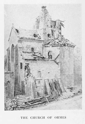
At the crossing with G. C. 6, keep straight on to Ormes, whose church, at the entrance to the village, was almost entirely destroyed.
Ormes
(See Itinerary, p. 122.)
This village, in addition to numerous subterranean passages and chambers, possesses the interesting 12th century Church St. Remi (photo below).
Its circular apse with cornice resting on corbels is barrel-vaulted. Colonnettes in the great bays of the steeple (in ruins) carry carved 12th century capitals.
The pointed vaulting of the southern transept is 12th century, and the ogival groining rests on Norman capitals. The doorway of the western façade dates from the second half of the 12th century, and although its porch was destroyed in 1853 it is still remarkable.
THE CHURCH OF ORMES
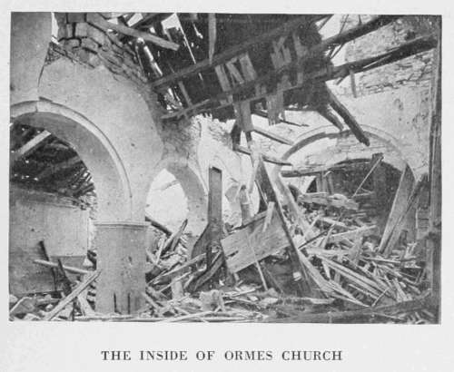
THE INSIDE OF ORMES CHURCH
It comprises three tierce-pointed arcades surmounted by a line of billet-moulding. The lateral arcades are blind, while the higher central arcading around the door is surmounted with three receding tori resting on crocketed foliate capitals. The lateral arcades have similar capitals but only one torus.
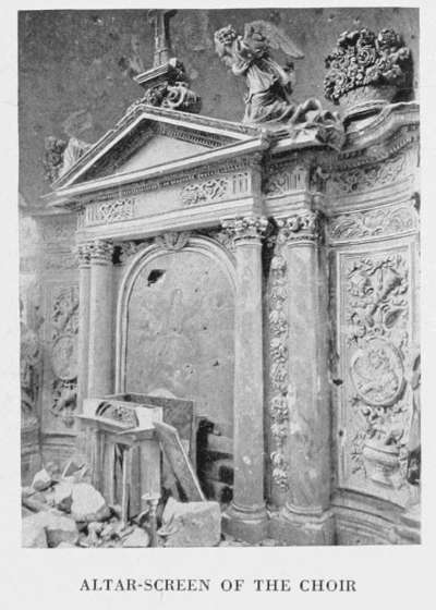
Inside the church are interesting 16th century statues: St. Barbara in stone and St. Catharine, painted and decorated, face the altar; St. Remi in stone, remarkable for its costume and decoration, stands above the altar of the northern chapel; a wooden Virgin surmounts the inner doorway.
ALTAR-SCREEN OF THE CHOIR
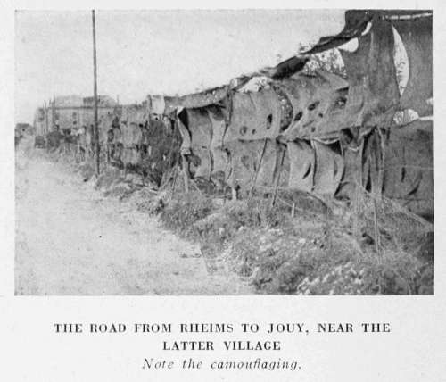
THE ROAD FROM RHEIMS TO JOUY, NEAR THE LATTER VILLAGE Note the camouflaging.
Return by the same road to the crossing with the road to Rheims (G. C. 6), where, opposite the Café du Joyeux Laboureur, turn to the right.
The road rises towards the Mountain of Rheims. Of the camouflaging seen in above photograph, only traces remain.
Shortly after, the tourist passes between the villages of Jouy and Pargny, whose houses border the road. Jouy (on the left) and Pargny (on the right) were bombarded by the Germans in June, 1915.
The Church of Jouy, visible from the road to Rheims, was almost entirely destroyed.
To visit the church of Pargny, turn to the right opposite the grocery stores, No. 262, then take the second street on the left (near a fine mansion partly in ruins).
About 100 yards farther on is the church, the belfry of which was destroyed. Return to the crossing with the main road to Rheims, where turn to the right.
The road continues to climb the northern slopes of the Mountain of Rheims. On a hill to the left, the Chapel of St. Lié dominates the surrounding plain. There is a very fine view of Rheims from here.
The top of the rise is reached soon afterwards. Descend the southern slopes, passing between the sidings of an important material and ammunition depot situated on the reverse side of the mountain out of sight of the enemy's observation-posts. On reaching the crossing half-way down the hill, leave on the left the two roads leading respectively to Ville Dommange and Courmas.
A short distance further on, after passing the road to Onrézy (on the left), take the following narrow road on the left, which passes between clumps of trees that were cut to pieces by shell-fire.
A little further on, on the right, is a cemetery containing the graves of some two hundred French, British and Italian soldiers.
Turn to the right after the cemetery. The road crosses a fine avenue bordered with shell-torn poplar trees, leading to the Castle of Commetreuil on the left. The village of Bouilly is reached soon afterwards.
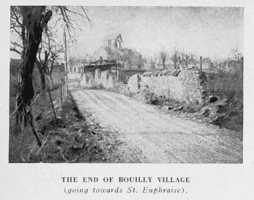
THE END OF BOUILLY VILLAGE (going towards St. Euphraise).
Bouilly—St. Euphraise—Clairizet
(See pp. 131-132, and Itinerary, p. 122.)
Bouilly was burnt by the Germans on September 12, 1914, under the pretext that the inhabitants had caused the death of two Uhlans killed the day before by French Chasseurs.
Turn to the right opposite the Church of Bouilly. There is a small cemetery on the right, just outside the village, containing several German graves.
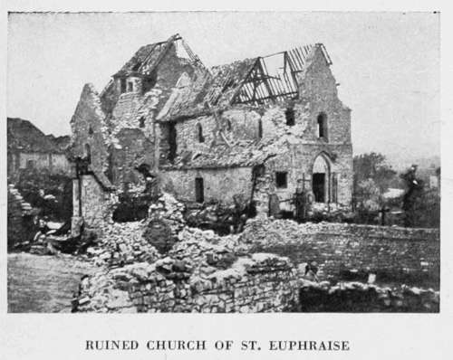
On reaching G.C. 6, leading to Rheims, turn to the right. Take the first road on the left, which passes through a small devastated wood, where batteries of guns were posted. Cross a small stream, and immediately afterwards the railway, then turn to the left into the village of St. Euphraise.
Turn to the right in the village, opposite the church. The road rises steeply to the hamlet of Clairizet, which was almost entirely destroyed. Pass by a "Calvary," composed of four large trees surrounding a cross, then turn to the left into a small narrow street.
RUINED CHURCH OF ST. EUPHRAISE
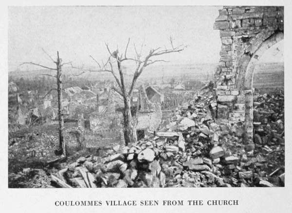
COULOMMES VILLAGE SEEN FROM THE CHURCH
Coulommes-la-Montagne—Vrigny
(See Itinerary, p. 122.)
The road rises, then descends to Coulommes-la-Montagne. Turn to the right at the entrance to the village. The church, in ruins, is on the left.
At the cross-roads just outside the village take G.C. 26 on the left. At first, the road dips rather abruptly, then rises to Vrigny.
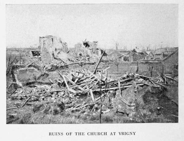
The Church of Vrigny, entirely in ruins, is on the right at the entrance to the village. Pass the Town Hall, leaving a public washing-place on the left, then turn to the right.
On leaving the village, take G.C. 26 on the left to the village of Gueux.
RUINS OF THE CHURCH AT VRIGNY
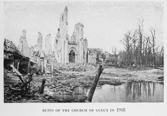
RUINS OF THE CHURCH OF GUEUX IN 1918
Gueux
(See pp. 131-132 and Itinerary, p. 122.)
Gueux is a small old-world village, with ancient houses, castle and church.
At the entrance to the village, a large square with trees, cut to pieces and devastated by the bombardment.
From the square, go to the Church on the right, now a heap of ruins. Seen through the trees from the square it forms a pitiful sight.
In the chapel, on the left of the main entrance, there was a fine piece of Renaissance carving.
GUEUX CHURCH IN 1917 Cardinal Luçon coming out of the Church (see above).
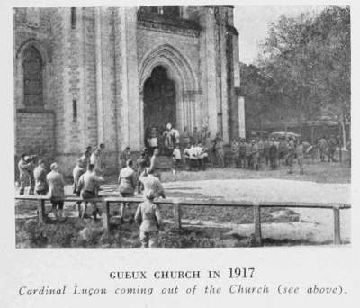
It was to Gueux that the Archbishop of Rheims, Mgr. Luçon, betook himself after the bombardments of April, 1917. The village cemetery contains many soldiers' graves. The Cardinal-Archbishop of Rheims presided at a pathetic ceremony held during the War in honour of the dead.
THE ANCIENT CASTLE OF GUEUX
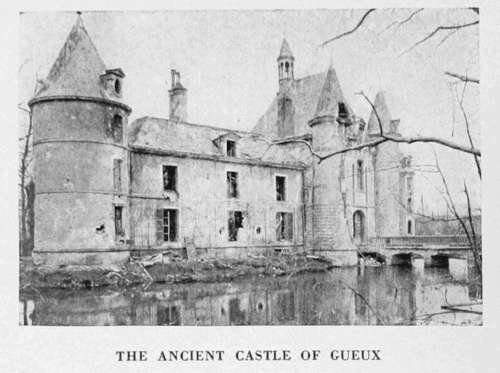
To visit the Castle, cross the square and take a small street on the left, which leads to the road to Rosnay (G.C. 27).
Turn to the left, and fifty yards further on take on foot the narrow street on the left, which leads to the old castle.
This ancient castle, where the Kings of France, on their way to Rheims to be consecrated, used to dine, suffered severely from the bombardments. Outwardly it has, however, retained its general appearance (photo above).
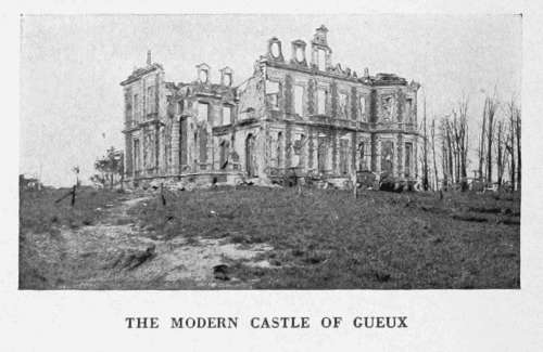
Return to the car, and go straight on to the fork in the roads to Rosnay and Prémecy. Facing the fork is the entrance to the park and modern Castle of Gueux, belonging to the Roederer family, which was completely destroyed (photo below).
Turn the car round at the above-mentioned fork and continue straight along G.C. 27.
Beyond the village of Gueux the road crosses numerous lines of trenches. Many shelters and ammunition depots can still be seen along the road. The National Road from Rheims to Soissons (N. 31) is reached soon afterwards. Near the cross-ways are the ruins of an inn.
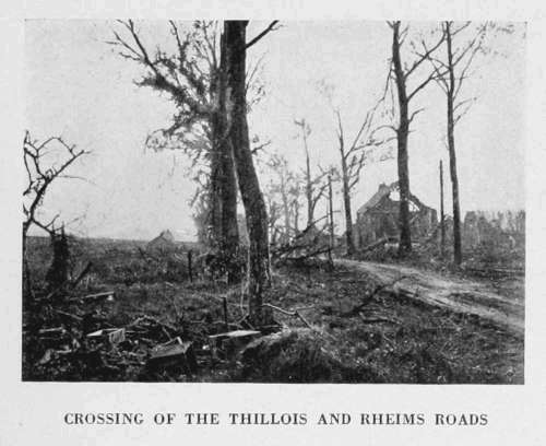
At this crossing, leave the National Road on the left and take the narrow road on the right which leads to Thillois.
THE MODERN CASTLE OF GUEUX
CROSSING OF THE THILLOIS AND RHEIMS ROADS
Thillois
(See Itinerary, p. 122.)
The Church of Thillois (late 12th century), now a heap of ruins, stood at the entrance to the village.
In 1914 it was still intact in all its vital parts. Its vaulting was pointed, with groining resting on columns, whose capitals were either Romanesque or Gothic. The nave had a timber roof.
The high-altar screen was a fine piece of sculptured stone-work of late 16th or early 17th century. In a niche above the altar, the Virgin, sitting on an X-shaped seat, was holding Jesus, clothed in a tunic and standing on her knee.
Leaving the church behind on the right, turn to the left, to reach the National Road. On the right is a small 18th century castle, behind a clump of fine stately trees, known as the Bosquet de Thillois. It was destroyed by shells.
Return to the National Road, turn to the right at the cross-roads, leaving on the left the road to Champigny, then return direct to Rheims, entering the city by the Avenue and Porte de Paris.
The Mountain of Rheims Battles
(See p. 14 and p. 122.)
The fighting known as the Battles of the Mountain of Rheims took place in 1918 over the whole of the area described above, i.e. from Bouilly to Thillois, via St. Euphraise, Coulommes, Vrigny and Gueux (see the Michelin Illustrated Guide: The Second Battle of the Marne).
The Mountain of Rheims prolongs the region of Tardenois to the east. It is an important military position between the Vesle and the Marne, as it dominates the plain of Champagne. The higher part of it is finely wooded, while on the lower slopes and eastern and southern edges are the famous Champagne vineyards (see Verzenay, pp. 171-172).
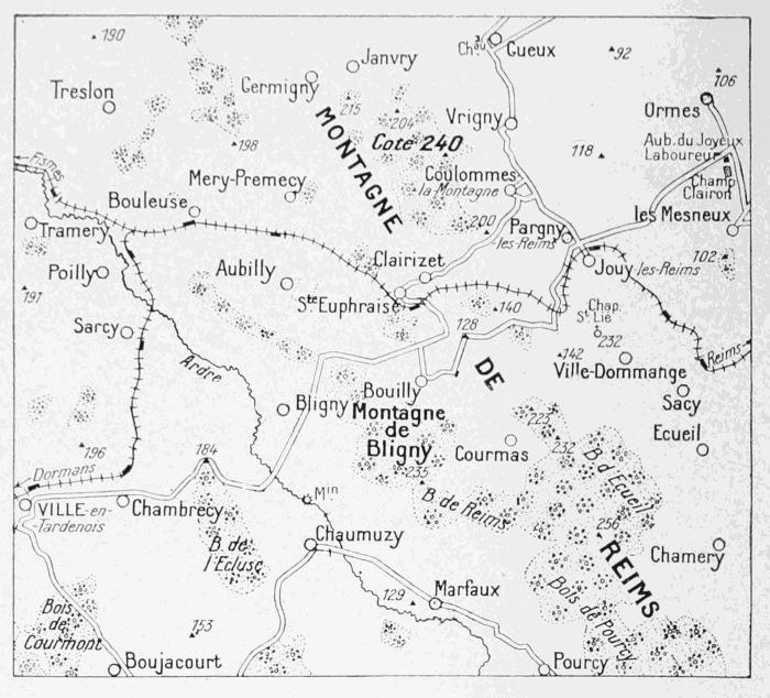
During the year 1918 the Germans made tremendous efforts to carry this position, the loss of which would have meant the fall of Rheims, leaving Epernay and Châlons-sur-Marne unprotected.
Although held to the east of Mountain, they obtained important successes on the west, where they reached the Marne, while in May they occupied the Woods of Courton and Le Roi. In July they crossed the Marne and advanced as far as Montvoisin, on the road to Epernay. Very fierce fighting took place, especially to the north-west of the Mountain at Bouilly, Bligny, St. Euphraise and Vrigny. These positions, and Hill 240 to the west of Vrigny, were several times lost and recaptured by the Allied troops under General Berthelot, French, Italian and British, who fought there side by side.
Vrigny was taken by the Germans on May 30, but retaken by the Allies on June 1 at the point of the bayonet. The same evening, four German regiments, after progressing slightly in the direction of Hill 240, were first checked, then driven back after bitter hand-to-hand fighting.
On June 9, the Germans were repulsed around Vrigny, after having sustained severe losses. On the 23rd, they rushed Bligny Hill, held by Italian troops, reaching the summit, but were shortly afterwards driven back. On the 29th, they sustained a like check at the same place.
In July they advanced their lines slightly towards Marfaux, Pourcy and Cuchery, but were unable to hold the captured ground. On the 18th, the Italians advanced in the region of Bouilly. On the 19th, Franco-British troops progressed towards St. Euphraise. On the 21st, the Allies carried Bouilly and St. Euphraise. On the 24th and 25th, in spite of desperate repeated efforts, the Germans were unable to hold Hill 240 which they had temporarily captured. On August 1 further enemy efforts to carry the Bligny uplands failed.
The region of Gueux—Thillois—Champigny was terribly ravaged by the war.
On September 11th, 1914, the French 5th Division, under General Mangin, drove the enemy from these positions, which remained in the French lines until May 30, 1918. Occupied by the Germans on May 31, after fierce fighting, they were completely devastated by artillery fire. Retaken by the French, then lost again in July, Thillois was finally recaptured on August 2, at the same time as Gueux.
On August 4, after having reached the Vesle at several points east of Fismes, French troops engaged a vigorous battle between Muizon and Champigny, and some of them succeeded in crossing the river the same day.
Champagne Wine
Wine-growing has always been a favourite industry in this part of France. The vineyards extend over the Rheims hills and along the valley of the Marne. In the hilly country around Rheims there are two distinct growths of wine: the Montagne proper, with its famous Verzy, Verzenay, Mailly, Ludes, Rilly and Villers "crus," and the Petite Montagne with its secondary "crus" of the Tardenois Valley, Hermonville Hills, St. Thierry, Nogent l'Abbesse and Cernay-les-Reims. The Montagne produces more especially black grapes for white wines.
Champagne wines were famous as far back as the 16th and 17th centuries. Henri IV. had a marked preference for the wines of Ay. The magnitude of the cellars still to be seen in the 16th and 17th century houses testifies to the importance of a trade, whose main outlets were Paris, Flanders, Belgium and Germany.
The Champagne wines of that period were red, and rivals of the famous Burgundy wines.
The vogue of Champagne wines as understood to-day dates back to the end of the 17th century. It was Dom Pérignon, cellarer of the Abbey of Hautevillers, near Epernay, who, if not actually the inventor of sparkling wines, first undertook to perfect them by blending the "crus" and preparing them with greater care.
In the last years of the reign of Louis XIV., and still more so under the Regency, the use of Champagne at Court gained ground, especially at the tables of the Duc de Vendôme and the Marquis de Sillery.
At that time Champagne was merely a "creamy" wine, i.e. semi-sparkling. The low breaking strain of the glass of those days would not have allowed of the higher pressure (six atmospheres) of the present-day wine. The discovery of the chemist François, who in 1836 at Châlons invented a special "densimeter," made it possible to calculate the amount of carbonic acid gas contained in the must, and to proportion the expansive force of the wine to the strength of the bottles, thus reducing losses by breakage, which for long had been very serious.
From the 19th century onwards, the production of Champagne wine has grown unceasingly. The number of bottles of sparkling Champagne placed on the market for sale in France and abroad rose from 19,145,481 (of which 16,705,719 went abroad) between April, 1875, and April, 1876, to 33,171,395 (of which 23,056,847 went abroad) between April, 1906 and April, 1907. During the first ten months of 1915, the exports of Champagne and sparkling wines were 630,140 wine-quarts, as against 1,092,660 wine quarts in 1914.