Chapter IX · SILURIAN.
Reading edition
Islands of Group I.
Flat-lying beds of light-coloured yellow and drab limestone occupy the lowlands of the southern and western parts of Southampton island, and also form outliers in depressions in the crystalline rocks on the north side of the island, notably at Duke of York bay.
A considerable collection of fossils was brought home from the beds forming the southern half of the west coast of the island. These have been examined by Dr. Ami and Mr. Lambe, whose determinations will be found in Appendix iv. The fossils show that the rocks contain a fauna closely resembling that of the Lake Winnipeg basin, and extend over a period from the Galena-Trenton to the Guelph and Niagara, or from the upper part of the Cambro-Silurian to high up in the Silurian.
Soundings taken on the even bottom of Fisher strait show that the limestones extend without a break to Coats island (to the southward of Southampton), where they occupy all of its surface except the portion at the east end of the island where the Archæan ridge crosses it. A few fossils from Mansfield island show that it also is formed of limestones of these horizons.
At Cape Chidley a collection of fossils from loose pieces of limestone corresponds with fossils from Akpatok island, and the direction of ice movement out of Hudson strait leaves little doubt that the loose limestone of Chidley came from that island. These fossils show a slightly wider range in age than the rocks of Southampton do; they extend from the Lower Galena-Trenton to the Lower Heidelberg.
West Coast of Hudson Bay.
The wide fringe of limestones which is found along the west shores of Hudson bay to the southward of Churchill do not come within the limits of this report. To the northward only Archæan rocks are found along the mainland until the northern half of Melville peninsula is reached, where Parry describes a wide area of sandstone, probably the base of the Cambro-Silurian, as separating the highlands of the interior from the western shores of the northern part of Fox channel. These rocks are continued on the north side of Fury and Hecla strait, where they are found on the west side of Baffin island fronting on Prince Regent inlet.
Islands of Group II.
The only known occurrence of Silurian limestone on the eastern side of Baffin island is at Silliman’s Fossil Mount, near the head of Frobisher bay, where the limestone forms a hill 1,000 yards long and 350 feet high, resting almost flat upon the crystalline rocks. Seventy-two species were identified by Schuchert from fossils brought back from this locality; he refers them all to the Galena-Trenton.
Little is known of the limestone about the great lakes, Nettilling and Amadjuak, in the interior of Baffin, beyond the meagre observations of Boas, who briefly refers to the limestone about Nettilling and along the east side of Fox channel. These limestones are probably an eastern extension of the Southampton area, but their exact age will remain unknown until fossils have been collected from them.
On the east side of Prince Regent inlet the rocks composing the high cliffs of Baffin island are the basal sandstone and shale overlaid by limestones, which in places are interbedded with beds of gypsum. These high cliffs of limestone extend eastward along the south shore of Lancaster sound to the mouth of Admiralty inlet, when they give place to the Archæan crystalline rocks, which rise slowly to the eastward from beneath the level of the sea, in a manner similar to that already described, on the north side of Lancaster sound.
Islands of Group III.
The large islands of this group are mainly built of Silurian limestones. North Somerset was the only island of this group visited in the Neptune, and all information concerning the others is derived from the observations made on earlier expeditions, and contained in Dawson’s summary of the northern geology.
Silurian limestones form the southern third of Banks island, being overlaid in the northern part by beds of Devonian and lower Carboniferous age. Dr. Rae reports the entire southern coast of Victoria island as being composed entirely of Silurian limestone.
‘The northern part of King William land, with Matty island to the east of it, are described by Sir John Ross as of limestone. Simpson states the eastern part of the south shore to be also of limestone, and Haughton dealing principally with the results of M’Clintock’s voyage writes as follows: “The east side of King William island, though composed of Silurian limestone like the rest of the island, is strewed with blocks of black and red micaceous gneiss, like that of Montreal island, and black metamorphic clay-slate, in which the crystals of mica are just commencing to be developed. It is probable that the granitoid rocks appear at the surface somewhere to the eastward of this locality.”
‘Numerous excellent though brief notes on the geology of the eastern and southwestern coasts of the Boothian peninsula occur in Sir John Ross’ remarkable narrative referred to. From these we learn that the eastern shore is composed of limestone to Port Logan (latitude 71° 21´), where a high range of hills—which is seen at a distance estimated at thirty miles inland at Creswell bay (further north) and runs north-and-south—impinged on the shore, and was found to consist of granitoid and gneissic rocks. Thence southward, from notes given in the body of the narrative, a narrow border of limestone may skirt the shore to about latitude 70° 35´, though the geological appendix does not make any mention of this.’
‘The narrow neck of the Boothian peninsula, which was crossed by Ross on several lines, is, from his description, composed of granitic rocks, with some outliers of limestone. One of these, definitely mentioned in the narrative but not in the geological appendix, is shown on the present map. On the coast of the mainland, west of the isthmus, the limestone formation is found resting on the granites of Lake Wittersted. Northwest from the isthmus the southwest coast of Boothia presents a range of granitoid hills, running northward, but becomes fringed by a low border of limestone near Cape Isabella, and this increases in width to the north, till an extensive flat limestone region is found in the vicinity of the magnetic pole.’
At Bellot strait a junction occurs between the granite and horizontal beds of Silurian limestone.
‘The entire western portion of Prince of Wales island is composed of Silurian limestone, which in the extreme west, at Cape Acworth, becomes chalky in character and non-fossiliferous, resembling the peculiar Silurian limestone found on the west side of Boothia Felix.’
The northern and eastern shores of North Somerset are of limestone, usually rising from the water in precipitous cliffs. These were examined at Port Leopold, where the cliffs rise sheer 1,000 feet from the sea. The bedding of the limestone is very distinct, and the face of the cliff has been sculptured by every runlet, so that between the horizontal and vertical markings the cliffs resemble on a gigantic scale the fluted walls of a castle. Fossils were collected from the lower beds of the cliff by M’Clintock, but none were collected on the present voyage.
Islands of Group IV.
The discovery of the Silurian limestone of the southern cliffs of North Devon and Cornwallis was made by Parry, while his collection of fossils was supplemented by those found by the Franklin search expeditions. Our knowledge of the geology of Ellesmere was, previous to the Sverdrup expedition, mainly due to the work of Feilden and De Rance in connection with the British expedition of 1875-76. Mr. P. Schei, the geologist who accompanied Sverdrup, collected much valuable information concerning the rock formations of Ellesmere. A summary of his observations is published as an appendix to Sverdrup’s ‘New Land,’ and is freely quoted from in the following.
The rocks found on the north side of the Archer plateau, in the eastern part of Ellesmere to the north of Cape Sabine, are very interesting geologically, as they show the only trace of an unbroken sequence of beds from the Huronian up through the Cambrian to the Silurian limestones so widely distributed on the Arctic islands. These rocks are described by Schei as follows:
‘At Cape Camperdown, on Bache peninsula, is found granite overlain by an arkose-like conglomerate sandstone, in flat strata, the dip being north-northwest. Its thickness here probably does not exceed 500 feet, though the contour swells to considerably greater magnitude by reason of intrusions of diabase, occasioning an additional thickness of perhaps 300 feet. At its upper part this sandstone merges gradually, by interstratification, into a series of gray, sandy and marl-like schists and limestone conglomerates. From a few inches up to a couple of yards in thickness these conglomerates and schists, continuously interstratified, build up a series 600 to 900 feet in thickness, interrupted by two compact beds of yellowish-gray dolomitic limestone about 150 feet in thickness. These are again overlain by a series similar to the underlying one, excepting that here the limestone conglomerates exceed the schists.’
‘In a detached block, in all probability originating from one of the two 150-foot beds, were traces of fossils, of which one, Leptoplastus sp., can be identified. In another detached block, whose mother rock is not known, was found Anomocare sp. It may be said with certainty after the finding of these fossils that this series contains deposits of the Cambrian age.’
‘The second series of conglomerates is overlain by a light grayish-white limestone in a bed some 300 feet in thickness, observed in the midst of the section of Cape Victoria Head. Indistinct Orthoceras, Lichas and Symphysurus assign this limestone to the Lower Silurian period.’
‘Above the othoceras-bearing, light-coloured limestone bed are some less extensive strata of alternating limestone and quartz-sandstone, and finally a 100-foot bed of close brown limestone of which certain layers are fossiliferous, and gave an Asaphus, traces of other Trilobites and some Gasteropods.’
‘Following the direction of the dip to the north side of Princess Marie bay we find it again, though seemingly somewhat abrupter, in the limestone beds of Norman Lockyer island. A fauna with Halysites sp., Zaphrentis sp., Orthisina sp., Rhynchonella sp., Leperditia sp., Illœnus sp., &c., assigns this limestone to Lower Silurian. It is again found with its fauna at the base of Cape Harrison; in this case with a thick super-incumbent bed of marly sandstone, quartz-sandstone, and finally extensive limestone conglomerate. This also occurs near the shore in Cape Prescott, indicating by its presence in the strike of the limestone of Norman Lockyer island the disturbance undergone by these tracts.
‘The line along which this disturbance took place is refound on the west side of Franklin Pierce bay, where the beds of limestone conglomerate dipping from the heights of Cape Harrison are cut off in the strike by a limestone, dark-gray in colour and broken into a breccia.’
In another place Schei hints that the rocks of the Cape Rawson beds, consisting largely of dark shales and impure limestones, found along the northern parts of the eastern shores of Ellesmere, may be of Triassic age, in sharply folded troughs of the older rocks, and consequently much younger than Cambrian, to which age they were referred by Fielden and De Rance.
Writing of the Silurian beds found on the southern coast of Ellesmere, Schei describes them as answering to the northern series, and their occurrence is as follows:—
‘There are at Havnefjord, in Jones sound, above some layers of quartz-sandstone, which entirely cover the gneiss-granite there, a series of limestone conglomerates with marly schists and pure limestones of a thickness of 1,200 to 1,500 feet. These are again overlain by a series of beds at least 2,000 feet thick, of hard, impure limestones, brown or yellowish-gray in colour, and often remarkably heavy.’
‘At South cape, which is entirely composed of this brown limestone, are found in the lower parts Maclurea sp., and Halysites sp., referable to the Middle Silurian, while west of it, at Bjorneborg, the upper parts of the series contain badly preserved remains of Orthocerata, Corals, and Pentamerus cfr. tenuistriatus. Hereafter the upper part of the limestone seems to be equivalent to the older Upper Silurian (Landovery). This brown limestone occurs from South cape westward to Kobbebugten in Hell Gate, and is broken at Lille Sandor, tectonic disturbance bringing up the underlying conglomerate series, and even the Archæan.’
‘On the south side of Rendalen appears the brown limestone of the capes, Series A, with a flat dip to the north-northwest; but on the north side of the valley is a division of dark schist, Series B, lying conformably above the beds of brown limestone. Associated with these schists, particularly in their lower and upper parts, are numerous layers of pure dark limestone, frequently fossiliferous. In Rendalen and in Kobbebugten, where this same division also appears, a quantity of material was collected, of which fifteen species are provisionally determined, among them being Favosites sp., Strophomena cfr. euglypha, Meristella in numbers, Rhynchonella cfr. borealis, Pentamerus cfr. galeatus, Spirifer cfr. elevatus. The period of this division in Series B is Wenlock.’
‘The upper part of Series B appears, among other places, at the headland north of Tunneldalen, in Hvalrosfjord. Above a black shale containing Monograptus sp. and Leperditia cfr. phaseolus is a bed of fragmentary limestone with Favosites, Strophomena cfr. pecten, Atrypa reticularis, Pterniea cfr. Sowerbyi. From a locality in Gaasefjord, on the same horizon, were taken Favosites cfr. Hisingeri, Favosites Gothlandicus, Thecia Swinderenana, Spirifer elevatus, Spirifer cfr. crispus, Strophomena corrugatella, Dav., Pterinea sp. According to these, the period of this upper part of Series B should be Ludlow. The thickness of the series is about 1,000 feet.’
‘In Hell Gate, as well as in Gaasefjord, these strata are overlaid by Series C; in its lower parts consisting of interstratified light and dark marl schists, which are somewhat sandy, while in its upper part appear pure quartz-sandstone beds and argillaceous sandstone. The collective thickness of these strata is about 1,000 feet in Gaasefjord, while in Hell Gate it is probably somewhat greater. No fossils were found in this series.’
‘At the base of the high cliffs at Indra Eide and Borgen appears Series C. In both of these places it is overlain by a dark limestone and black shale, partially fossiliferous. This dark limestone and shale are the lowest layers in a series of strata at least 1,500 feet in thickness, Series D, which appears in the profiles on both sides of Gaasefjord, from Borgen to the foot of Vargtoppen (Wolf Top), and from Indre Eide to Skrabdalen.’
‘In Series Da occurs Atrypa reticularis in great quantities, but little else. On the other hand, there are preliminary determined in Db about fifty-five species, of which may be mentioned: Favosites sp. div., Columnaria sp., Cyathophyllum sp. cfr. hexagonum, Recaplaculites sp., Fenestella sp., Homalonotus sp., Burmeisteria sp., Dechenella sp., Proetus sp., Orthis striatula, Leptaena sp., Strophomena, Streptorhyncus, Atrypa reticularis, aspera; Rhynchonella (Pugnax) cfr. reniformis, pugnus, Productus cfr. prolongus, Spirifer of the Verneuilli Murch. type, a peculiar Pentameride, Terebratula cfr. Dielasma, Pterinea sp., Modiolopsis sp., Lucina sp. div., Bellerophon sp., Platyceras sp., Orthoceras sp., Gomphoceras, gigantic nautilus and ganoid scales.’
‘The fauna in Dc is merely a repetition, and in the case of certain species, a further development, of the forms found in Db. It will thus be seen that there is a spring in regard to the fauna between the upper layers in Series B and the lower ones in Series D, which more particularly resemble Lower or Middle Devonian. The concordantly embedded (?) Series C might, therefore, be thought to represent uppermost Silurian as well as lowest Devonian.’
‘Divisions Dd and Df are poor in fossils, and are partly shale divisions. In the impure limestone of Dg occur again numerous fossils, among which are Atrypa reticularis, Rhynchonella cfr. cuboides, Spirifer cfr. undifera, Productus sp., Terebratula cfr. Dielasma, Pterinea sp., Avicula sp., Modiolopsis sp., Pleurotomaria sp., Proetus sp. Traces of placoderm fish are also met with. Above these strata are beds of purer limestone Dh, and above these again some less pure, Di. The uppermost strata of Di alternate with strata of light-gray quartz-sandstone terminating in a clay-sandstone, which in places is richly fossiliferous, though the fossils are in a bad state of preservation. Among these are lamellibranchiata, Dechenella sp., remains of Holoptychius, &c.’
‘This argillaceous sandstone is simultaneously the last link in Series D and the first in Series E. This is a huge collection of quartz-sandstone strata building up the mountains on both sides of the inner part of Gaasefjord. The lowest part, which is 900 to 1,200 feet in thickness, consists almost exclusively of quartz-sandstone. On the north side of Skrabdalen, in the sandstone profile, occur conglomerate strata, half an inch to an inch in thickness. In these were found considerable remains of Coccosteus sp., Holoptychius sp., and Modolia angusta. In the same strata with these were also seen indeterminable plant-fossils. Slightly higher up in the profile, however, in a black shale which occurred in two lentiform masses, eighteen inches and six feet in thickness, were found numerous plant-fossils.’
‘Professor Nathorst, of Stockholm, who has kindly undertaken the examination of these, says that among others are Archœopteris fissilis Schmalh. and Arch. archetypus Schmalh., both characteristic of Upper Devonian. In examining the material collected, Professor Nathorst also found with the plant remains some remains of fishes.’
From the above it will be seen that on the southern side of Ellesmere there is a complete succession of strata, bearing fossils from Middle Silurian age up to the Upper Devonian. These strata have an aggregate thickness of 8,000 feet, and form the thickest and most carefully measured section of the Silurian and Devonian beds of the Arctics.
On the southern and southwestern parts of North Devon the Silurian strata are much thinner than those described by Schei. At Cuming creek the Archæan gneisses were found overlain unconformably by red and purple arenaceous shales and thin bedded sandstones having an aggregate thickness of fifty to one hundred feet. These in turn were succeeded by beds of impure limestone of light-gray or creamy colour. The beds are usually under two feet in thickness, and separated by thinner beds containing a considerable amount of clay. These light-coloured limestones have a thickness of over 1,000 feet in the cliffs on both sides of the creek. The sides of the cliffs are covered with broken limestone, so that it was impossible to measure a section up them, but in two or three places a darker coloured limestone conglomerate was found, made up of small pebbles cemented by a dark shaly matrix. Fossils are only found in the beds immediately overlying the dark shales and sandstones of the base. These show that the lower limestone is of Silurian age, about the horizon of the Niagara.
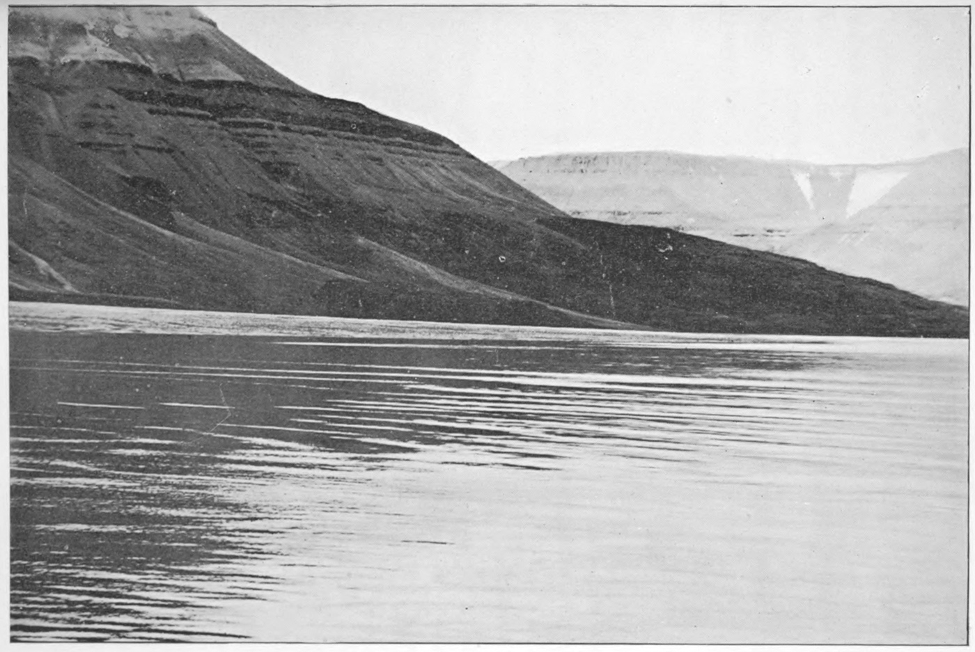
Limestone Cliffs of North Devon Island.
Similar conditions prevail in the cliffs at Beechey island, where a large collection of fossils was obtained from the lower limestone beds, while others, picked up loose, but evidently fallen from the cliffs above showed that the upper beds passed close to if not into the Devonian, as stated in Appendix IV.
Similar Silurian limestones constitute the island of Cornwallis, to the westward of North Devon, while in the remaining Parry islands farther west the Silurian strata are lost beneath the Devonian and Carboniferous rocks of those islands.