INDIAN GEOGRAPHICAL NAMES.
Reading edition
Hudson's River and Its Islands.
Muhheakun'nuk, "The great waters or sea, which are constantly in motion, either ebbing or flowing," was written by Chief Hendrick Aupaumut, in his history of the Muhheakun'nuk nation, as the name of Hudson's River, in the Stockbridge dialect, and its meaning. The first word, Muhheakun, was the national name of the people occupying both banks of the river from Roelof Jansen's Kill, a few miles south of Catskill, on the east side of the river, north and east with limit not known, and the second -nuk, the equivalent of Massachusetts -tuk, Lenape -ittuk, "Tidal river, or estuary," or "Waters driven by waves or tides," with the accessory meaning of "great." Literally, in application, "The great tidal river of the Muhheakan'neuw nation." The Dutch wrote the national name Mahikan, Maikan, etc., and the English of Connecticut wrote Mohegan, which was claimed by Drs. Schoolcraft and Trumbull to be derived from Maingan (Cree Mahéggun), "Wolf"—"an enchanted wolf, or a wolf of supernatural powers." From their prevailing totem or prevailing coat-of-arms, the Wolf, the French called them Loups, "wolves," and also Manhingans, including under the names "The nine nations gathered between Manhattan and Quebec." While the name is generic its application to Hudson's River was probably confined to the vicinity of Albany, where Chief Aupaumut located their ancient capital under the name of Pem-po-tow-wut-hut Muh-hea-kan-neuw, "The fire-place of the Muh-hea-kan-nuk nation." [FN] The Dutch found them on both sides of the river north of Catskill, with extended northern and eastern alliances, and south of that point, on the east side of the river, in alliance with a tribe known as Wappans or Wappings, Wappani, or "East-side people," the two nations forming the Mahikan nation of Hudson's River as known in history. (See Wahamensing.)
[FN] Presumed to have been at what is now known as Scho-lac, which see.
Father Jogues, the French-Jesuit martyr-missionary, wrote in 1646, Oi-o-gué as the Huron-Iroquoian name of the river, given to him at Sarachtoga, with the connection "At the river." "Ohioge, river; Ohioge-son, at the long river," wrote Bruyas. Arent van Curler wrote the same name, in 1634, Vyoge, and gave it as that of the Mohawk River, correcting the orthography, in his vocabulary, to "Oyoghi, a kill" or channel. It is an Iroquoian generic applicable to any principal stream or current river, with the ancient related meaning of "beautiful river."
It is said that the Mohawks called the river Cohohataton. I have not met that name in records. It was quoted by Dr. Schoolcraft as traditional, and of course doubtful. He wrote it Kohatatea, and in another connection wrote "-atea, a valley or landscape." It is suspected that he coined the name, as he did many others. Shate-muck is quoted as a Mohegan [FN-1] name, but on very obscure evidence, although it may have been the name of an eel fishing-place, or a great fishing-place (-amaug). Hudson called the stream "The River of the Mountains." On some ancient maps it is called "Manhattans River." The Dutch authorities christened it "Mauritus' River" in honor of their Staat-holder, Prince Maurice. The English recognized the work of the explorer by conferring the title "Hudson's River." It is a fact established that Verrazano visited New York harbor in 1524, and gave to the river the name "Riviere Grande," or Great River; that Estevan Gomez, a Spanish navigator who followed Verrazano in 1525, called it "St. Anthony's River," a name now preserved as that of one of the hills of the Highlands, and it is claimed that French traders visited the river, in 1540, and established a château on Castle [FN-2] Island, at Albany, [FN-3] and called the river "Norumbega." It may be conceded that possibly French traders did have a post on Castle Island, but "Norumbega" was obviously conferred on a wide district of country. It is an Abnaki term and belonged to the dialect spoken in Maine, where it became more or less familiar to French traders as early as 1535. That those traders did locate trading posts on the Penobscot, and that Champlain searched for their remains in 1604, are facts of record. The name means "Quiet" or "Still Water." It would probably be applicable to that section of Hudson's River known as "Stillwater," north of Albany, but the evidence is wanted that it was so applied. Had it been applied by the tribes to any place on Hudson's River, it would have remained as certainly as Menaté remained at New York.
[FN-1] "Mohegans is an anglicism primarily applied to the small band of Pequots under Uncas." (Trumbull.) While of the same linguistic stock, neither the name or the history of Uncas's clan should be confused with that of the Mahicani of Hudson's River.
[FN-2] Introduced by the Dutch—Kasteel. The Indians had no such word. The Delawares called a house or hut or a town that was palisaded, Moenach, and Zeisberger used the same word for "fence"—an enclosure palisaded around. Eliot wrote Wonkonous, "fort."
[FN-3] It is claimed that the walls of this fort were found by Hendrick Christiansen, in 1614; that they were measured by him and found to cover an area of 58 feet; that the fort was restored by the Dutch and occupied by them until they were driven out by a freshet, occasioned by the breaking up of the ice in the river in the spring of 1617; that the Dutch then built what was subsequently known as Fort Orange, at the mouth of the Tawalsentha, or Norman's Kill, about two miles south of the present State street, Albany, and that Castle Island took that name from the French château—all of which is possible, but for conclusive reasons why it should not be credited, the student may consult "Norumbega" in Winsor's "Narrative and Critical History of America." Wrote Dr. Trumbull: "Theuet, in La Cosmographie Universella, gives an account of his visit, in 1656, to 'one of the finest rivers in the whole world, which we call Norumbeque, and the aboriginees Agoncy,' now Penobscot Bay."
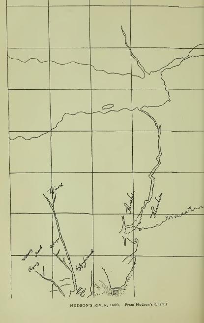
Manhattan, now so written, does not appear in the Journal of Hudson's exploration of the river in 1609. On a Spanish-English map of 1610, "Made for James I," and sent to Philip III by Velasco in letter of March 22, 1611, [FN-1] Mannahatin is written as the name of the east side of the river, and Mannahata as that of the west side. From the former Manhattan, and from it also the name of the Indians "among whom" the Dutch made settlement in 1623-4, otherwise known by the general name of Wickquaskecks, as well as the name of the entire Dutch possessions. [FN-2] Presumably the entries on the Spanish-English map were copied from Hudson's chart, for which there was ample time after his return to England. Possibly they may have been copied by Hudson, who wrote that his voyage "had been suggested" by some "letters and maps" which "had been sent to him" by Capt. Smith from Virginia. Evidently the notations are English, and evidently, also, Hudson, or his mate, Juet, had a chart from his own tracing or from that of a previous explorer, which he forwarded to his employers, or of which they had a copy, when he wrote in his Journal: "On that side of the river called Mannahata," as a reference by which his employers could identify the side of the river on which the Half-Moon anchored, [FN-3] Presumably the chart was drawn by Hudson and forwarded with his report, and that to him belongs the honor of reducing to an orthographic form the first aboriginal name of record on the river which now bears his name. Five years after Hudson's advent Adriaen Block wrote Manhates as the name of what is now New York Island, and later, De Vries wrote Manates as the name of Staten Island, both forms having the same meaning, i. e., "Small island." There have been several interpretations of Mannahatin, the most analytical and most generally accepted being by the late Dr. J. H. Trumbull: "From Menatey (Del.), 'Island'—Mannahata 'The Island,' the reference being to the main land or to Long Island as the large island. Menatan (Hudson's Mannah-atin, -an or -in, the indefinite or diminutive form), 'The small island,' or the smaller of the two principal islands, the Manhates of Adriaen Block. [FN-4] Manáhtons, 'People of the Island,' Manáhatanesen, 'People of the small islands.'" [FN-5] The Eastern-Algonquian word for "Island" (English notation), is written Munnoh, with formative -an (Mun-nohan). It appears of record, occasionally, in the vicinity of New York, presumably introduced by interpreters or English scribes. The usual form is the Lenape Menaté, Chippeway Minnis, "Small island," classed also as Old Algonquian, or generic, may be met in the valley of the Hudson, but the instances are not clear. It is simply a dialectic equivalent of Del. Ménates. (See Monach'nong.) Van Curler wrote in his Mohawk vocabulary (1635), "Kanon-newaga, Manhattan Island." The late J. W. Powell, Director of the Bureau of Ethnology, wrote me: "In the alphabet of this office the name may be transliterated Kanoñnò'ge. It signifies 'Place of Reeds.'" Perhaps what was known as the "Reed Valley" was referred to, near which Van Twiller had a tobacco plantation where the Indians of all nations came to trade. (See Saponickan.) The lower part of the island was probably more or less a district of reed swamps.
[FN-1] Brown's "Genesis of the United States," 327, 457, 459, ii, 80.
[FN-2] Colonial History of New York.
[FN-3] Hudson anchored in the bay near Hoboken. Near by his anchorage he noticed that "there was a cliff that looked of the color of white green." This cliff is near Elysian Fields at Hoboken. (Broadhead.) The cliff is now known as Castle Point.
[FN-4] The reference to Adriaen Block is presumably to the "Carte Figurative" of 1614-16, now regarded as from Block's chart.
[FN-5] "Composition of Indian Geographical Names," p. 22.
Pagganck, so written in Indian deed of 1637, as the name of Governor's Island—Peconuc, Denton, is an equivalent of Pagán'nak, meaning literally "Nut Island." Also written Pachgan, as in Pachganunschi, "White walnut trees." (Zeisb.) Denton explained, "Because excellent nut trees grew there." [FN] The Dutch called it "der Nooten Eilandt," literally "The Walnut Island," from whence the modern name, "Nutten Island." The island was purchased from the Indian owners by Director Wouter van Twiller, from whose occupation, and its subsequent use as a demense of the governors of the Province, its present name.
[FN] Denton's "Description of New York," p. 29. Ward's and Blackwell's islands were sold to the Dutch by the Marechawicks, of Long Island, in 1636-7. Governor's Island was sold in the same year by the Tappans, Hackinsacks and Nyacks, the grantors signing themselves as "hereditary owners." Later deeds were signed by chiefs of the Raritans and Hackinsacks.
Minnisais is not a record name. It was conferred on Bedloe's Island by Dr. Schoolcraft from the Ojibwe or Chippeway dialect, [FN] in which it means "Small island."
[FN] The Objibwe (Objibwai) were a nation of three tribes living northwest of the great lakes, of which the Ojibwai or Chippeway represented the Eagle totem. It is claimed by some writers that their language stands at the head of the Algonquian tongues. This claim is disputed on behalf of the Cree, the Shawanoe, and the Lenape or Delaware. It is not assumed that Ojibwe (Chippeway) terms are not Algonquian, but that they do not strictly belong to the dialects of the Hudson's river families. Rev. Heckewelder saw no particular difference between the Ojibwe and the Lenape except in the French and the English forms. Ojibwe terms may always be quoted in explanations of the Lenape.
Kiosh, or "Gull Island," was conferred on Ellis Island by Dr. Schoolcraft from the Ojibwe dialect. The interpretation is correct presumably.
Tenkenas is of record as the Indian name of what is now known as Ward's Island. [FN] It appears in deed of 1636-7. It means "Small island," from Tenke (Len.), "little."
[FN] The Dutch called the island Onvruchtbaar, "Unfruitful, barren." The English adopted the signification, "Barren," which soon became corrupted to "Barrent's," to which was added "Great" to distinguish it from Randal's Island, which was called "Little Barrent's Island." Barn Island is another corruption. Both islands were "barren" no doubt.
Monatun was conferred by Dr. Schoolcraft on the whirlpool off Hallet's Cove, with the explanation, "A word conveying in its multiplied forms the various meanings of violent, forcible, dangerous, etc." Dr. Schoolcraft introduced the word as the derivative of Manhatan, which, however, is very far from being explained by it. Hell-gate, a vulgar orthography of Dutch Hellegat, has long been the popular name of the place. It was conferred by Adriaen Block, in 1614-16, to the dangerous strait known as the East River, from a strait in Zealand, which, presumably, was so called from Greek Helle, as heard in Hellespont—"Sea of Helle"—now known as the Dardanelles—which received its Greek name from Helle, daughter of Athamas, King of Thebes, who, the fable tells us, was drowned in passing over it. Probably the Dutch sailors regarded the strait as the "Gate of Hell," but that is not the meaning of the name—"a dangerous strait or passage." In some records the strait is called Hurlgate, from Dutch Warrel, "Whirl," and gat, "Hole, gap, mouth"—substantially, "a whirlpool."
Monachnong, deed to De Vries, 1636; Menates, De Vries's Journal; Ehquaons (Eghquaous, Brodhead, by mistake in the letter n), deed of 1655, and Aquehonge-Monuchnong, deed to Governor Lovelace, 1670, are forms of the names given as that of Staten Island, and are all from Lenape equivalents. Menates means "Small island" as a whole; Monach'nong means a "Place on the island," or less than the whole, as shown by the claims of the Indians in 1670, that they had not previously sold all the island. (Col. Hist. N. Y., xiii, 453.) It is the equivalent of Menach'hen, Minsi; Menach'n, Abn., "Island," and ong, locative; in Mass. Mimnoh-han-auke. (See Mannhonake.) Eghquaons and Aquehonga are equivalents, and also equivalents of Achquoanikan-ong, "Bushnet fishing-place," of which Acquenonga is an alternate in New Jersey. (Nelson's "Indians of New Jersey," 122.) In other words, the Indians conveyed places on the island, including specifically their "bushnet fishing-place," and by the later deed to Lovelace, conveyed all unsold places. The island was owned by the Raritans who resided "behind the Kol," and the adjoining Hackensacks. (Deed of 1655.) Its last Indian occupants were the Nyacks, who removed to it after selling their lands at New Utrecht. (See Paganck note.)
Minnahanock, given as the name of Blackwell's Island, was interpreted by Dr. Trumbull from Munnŏhan, Mass., the indefinite form of Munnŏh, "Island," and auke, Mass., "Land" or place. Dr. O'Callaghan's "Island home," is not in the composition. (See Mannhonake.)
On Manhattan Island.
Kapsee, Kapsick, etc., the name of what was the extreme point of land between Hudson's River and the East River, and still known as Copsie Point, was claimed by Dr. Schoolcraft to be Algonquian, and to mean, "Safe place of landing," which it may have been. The name, however, is pretty certainly a corruption of Dutch Kaap-hoekje, "A little cape or promontory."
Saponickan and Sapohanican are the earliest forms of a name which appears later Sappokanican, Sappokanikke, Saponican, Shawbackanica, Taponkanico, etc. "A piece of land bounded on the north by the strand road, called Saponickan" (1629); "Tobacco plantation near Sapohanican" (1639); "Plantation situate against the Reed Valley beyond Sappokanican" (1640). Wouter van Twiller purchased the tract, in 1629, for the use of the Dutch government and established thereon a tobacco plantation, with buildings enclosed in palisade, which subsequently became known as the little village of Sapokanican—Sappokanican, Van der Donck—and later (1721) as Greenwich Village. It occupied very nearly the site of the present Gansevort market. The "Strand road" is now Greenwich Street. It was primarily, an Indian path along the shore of the river north, with branches to Harlem and other points, the main path continuing the trunk-path through Raritan Valley, but locally beginning at the "crossing-place," or, as the record reads, "Where the Indians cross [the Hudson] to bring their pelteries." [FN-1] "South of Van Twiller's plantation was a marsh much affected by wild-fowl, and a bright, quick brook, called by the Dutch 'Bestavar's Kil,' and by the English 'Manetta Water.'" [FN-2] (Half-Moon Series.) Saponickan was in place here when Van Twiller made his purchase (1629), as the record shows, and was adopted by him as the name of his settlement. To what feature it referred cannot be positively stated, but apparently to the Reed Valley or marsh. It has had several interpretations, but none that fare satisfactory. The syllable pon may denote a bulbous root which was found there. (See Passapenoc.) The same name is probably met in Saphorakain, or Saphonakan, given as the name of a tract described as "Marsh and canebrake," lying near or on the shore of Gowanus Bay, Brooklyn. (See Kanonnewage, in connection with Manhattan.)
[FN-1] "Through this valley pass large numbers of all sorts of tribes on their way north and east." (Van Tienhoven, 1650.) "Where the Indians cross to bring their pelteries." (De Laet, 1635.) The crossing-place is now known as Pavonia. The path crossed the Spuyten Duyvil at Harlem and extended along the coast east. To and from it ran many "paths and roads" on Manhattan, which, under the grant to Van Twiller, were to "forever remain for the use of the inhabitants." The evidence of an Indian village at or near the landing is not tangible. The only village or settlement of which there is any evidence was that which gathered around Van Twiller's plantation, which was a noted trading post for "all sorts of tribes."
[FN-2] Bestevaar (Dutch) means "Dear Father," and Manetta (Manittoo, Algonquian), means, "That which surpasses, or is more than ordinary." Water of more than ordinary excellence. (See Manette.)
Nahtonk, Recktauck, forms of the name, or of two different names, of Corlear's Hook, may signify, abstractively, "Sandy Point," as has been interpreted; but apparently, Nahtonk [FN-1] is from Nâ-i, "a point or corner," and Recktauck [FN-2] from Lekau (Requa), "Sand gravel"—a "sandy place." It was a sandy point with a beach, entered, on English maps, "Crown Point."
[FN-1] Naghtonk (Benson); Nahtonk (Schoolcraft); Rechtauck (record). It was to the huts which were located here to which a clan of Long Island Indians fled for protection, in February, 1643, and were inhumanly murdered by the Dutch. The record reads: "Where a few Rockaway Indians from Long Island, with their chief, Niande Nummerus, had built their wigwams." (Brodhead.) "And a party of freemen behind Corlear's plantation, on the Manhattans, who slew a large number and afterwards burned their huts." The name of the Chief, Niande Nummerus, is corrupted from the Latin Nicanda Numericus, the name of a Roman gens. De Vries wrote, "Hummerus, a Rockaway chief, who I knew."
[FN-2] See Rechqua-hackie. "The old Harlem creek, on Manhattan Island, was called Rechawanes, or 'Small, sandy river.'" (Gerard.)
Warpoes is given as the name of "a small hill" on the east side and "near ye fresh water" lake or pond called the Kolk (Dutch "pit-hole"), which occupied several acres in the neighborhood of Centre Street. [FN-1] The Indian name is that of the narrow pass between the hill and the pond, which it described as "small" or narrow. (See Raphoos.)
In the absence of record names, the late Dr. Schoolcraft conferred, on several points, terms from the Ojibwe or Chippeway, which may be repeated as descriptive merely. A hill at the corner of Charlton and Varick streets was called by him Ishpatinau, "A bad hill." [FN-2] A ridge or cliff north of Beekman Street, was called Ishibic, "A bad rock;" the high land on Broadway, Acitoc; a rock rising up in the Battery, Abie, and Mount Washington, Penabic, "The comb mountain." The descriptions are presumably correct, but the features no longer exist.
[FN-1] "By ye edge of ye hill by ye fresh water." (Cal. N. Y. Land Papers, 17.) The Dutch name ran into Kalch, Kolack and Collect, and in early records "Kalch-hock." from its peculiar shape, resembling a fish-hook.
[FN-2] "At ye sand Hills near the Bowery." (Cal. N. Y. Land Papers. 17.) Ishpetouga was given by the same writer to Brooklyn Heights, with the explanation "High, sandy banks," but the term does not describe the character of the elevation. (See Espating.)
Muscota is given as the name of the "plain or meadow" known later as Montagne's Flat, between 108th and 124th streets. (Col. Hist. N. Y., xiv.) It also appears as the name of a hill, and in Muskuta as that of the great flat on the north side of the Spuyten Duivel. "The first point of the main land to the east of the island Papirinimen, there where the hill Muskuta is." The hill takes the name from the meadows which it describes. "Moskehtu, a meadow." (Eliot.)
Papinemen (1646), Pahparinnamen (1693), Papirinimen (modern), are forms of the Indian name used interchangeably by the Dutch with Spuyten Duivel to designate a place where the tide-overflow of the Harlem River is turned aside by a ridge and unites with Tibbet's Brook, constituting what is known as the Spuyten Duivel Kill, correctly described by Riker in his "History of Harlem": "The narrow kill called by the Indians Pahparinamen, which, winding around the northerly end of Manhattan, connected the Spuyten Duyvil with the Great Kill or Harlem River, gave its name to the land contiguous to it on either side." The locative of the name is clearly shown in the boundaries of the Indian deed to Van der Donck, in 1646, and in the subsequent Philipse Patent of 1693, the former describing the south line of the lands conveyed as extending from the Hudson "to Papinemen, called by our people Spuyten Duivel," and the latter as extending to and including "the neck, island or hummock, Pahparinnamen," on the north side of the passage, at which point, in the early years of Dutch occupancy, a crossing place or "wading place" was found which had been utilized by the Indians for ages, and of which Jasper Bankers and Peter Sluyter wrote, in 1679-80, "They can go over this creek, at dead or low water, upon the rocks and reefs, at a place called Spuytten Duyvel." From this place the name was extended to the "island or hummock" and to what was called "the Papirinameno Patent," at the same point on the south side of the stream, to which it was claimed to belong in 1701. Mr. Riker's assignment of the name to the Spuyten Duivel passage is probably correct. The "neck, island or hummock" was a low elevation in a salt marsh or meadow. It was utilized as a landing place by the Indians whose path ran from thence across the marsh "to the main." Later, the path was converted to a causeway or road-approach to what is still known as King's Bridge. A ferry was established here in 1669 and known as "The Spuyten Duyvil passage or road to and from the island to the main." In 1692 Governor Andros gave power to the city of New York to build a bridge "over the Spiken devil ferry," and the city, with the consent of the Governor, transferred the grant to Frederick Philipse. In giving his consent the Governor made the condition that the bridge "should thenceforth be known and called King's Bridge." It was made a free bridge in 1758-9. The "island or hummock" came to be the site of the noted Macomb mansion.
The name has not been satisfactorily translated. Mr. Riker wrote, "Where the stream closes," or is broken off, recognizing the locative of the name. Ziesberger wrote, Papinamen, "Diverting," turning aside, to go different ways; accessorily, that which diverts or turns aside, and place where the action of the verb is performed. Where the Harlem is turned aside or diverted, would be a literal description.
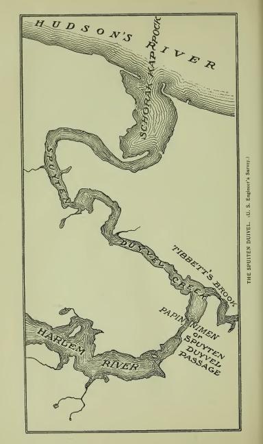
Spuyten Duyvil, now so written, was the early Dutch nickname of the Papirinimen ford or passage, later known as King's Bridge. "By our people called," wrote Van der Donck in 1652, indicating conference by the Dutch prior to that date. It simply described the passage as evil, vicious, dangerous. Its derivatives are Spui, "sluice;" Spuit, "spout;" Spuiten, "to spout, to squirt, to discharge with force," as a waterspout, or water forced through a narrow passage. Duyvil is a colloquial expression of viciousness. The same name is met on the Mohawk in application to the passage of the stream between two islands near Schenectady. The generally quoted translation, "Spuyt den Duyvil, In spite of the Devil," quoted by Brodhead as having been written by Van der Donck, has no standing except in Irving's "Knickerbocker History of New York." Van der Donck never wrote the sentence. He knew, and Brodhead knew, that Spuyt was not Spijt, nor Spuiten stand for Spuitten. The Dutch for "In spite of the Devil," is In Spijt van Duivel. The sentence may have been quoted by Brodhead without examination. It was a popular story that Irving told about one Antony Corlear's declaration that he would swim across the ford at flood tide in a violent storm, "In spite of the devil," but obviously coined in Irving's brain. It may, however, had for its foundation the antics of a very black and muscular African who was employed to guard the passage and prevent hostile Indians as well as indiscreet Dutchmen from crossing, and who, for the better discharge of his duty, built fires at night, armed himself with sword and firebrands, vociferated loudly, and acted the character of a devil very well. At all events the African is the only historical devil that had an existence at the ford, and he finally ran away and became merged with the Indians. Spiting Devil, an English corruption, ran naturally into Spitting Devil, and some there are who think that that is a reasonably fair rendering of Dutch Spuiten. They are generally of the class that take in a cant reading with a relish.
Shorakkapoch and Shorackappock are orthographies of the name of record as that of the cove into which the Papirinemen discharges its waters at a point on the Hudson known as Tubby Hook. It is specifically located in the Philipse charter of 1693: "A creek called Papparinnemeno which divides New York Island from the main land, so along said creek as it runs to Hudson's River, which part is called by the Indians Shorackhappok," i. e. that part of the stream on Hudson's River. In the patent to Hugh O'Neil (1666): "To the Kill Shorakapoch, and then to Papirinimen," i. e., to the cove and thence east to the Spuyten Duyvil passage. "The beautiful inlet called Schorakapok." (Riker.) Dr. Trumbull wrote "Showaukuppock (Mohegan), a cove." William R. Gerard suggests "P'skurikûppog (Lenape), 'forked, fine harbor,' so called because it was safely shut in by Tubby Hook, [FN-1] and another Hook at the north, the current taking a bend around the curved point of rock (covered at high tide) that forked or divided the harbor at the back." Dr. Brinton wrote: "W'shakuppek, 'Smooth still water;' pek, a lake, cove or any body of still water; kup, from kuppi, 'cove.'" Bolton, in his "History of Westchester County," located at the mouth of the stream, on the north side, an Indian fort or castle under the name of Nipinichen, but that name belongs on the west side of the Hudson at Konstable's Hook, [FN-2] and the narrative of the attack on Hudson's ship in 1609, noted in Juet's Journal, does not warrant the conclusion that there was an Indian fort or castle in the vicinity. A fishing village there may have been. At a later date (1675) the authorities permitted a remnant of the Weckquasgecks to occupy lands "On the north point of Manhattan Island" (Col, Hist. N. Y., xiii, 494), and the place designated may have been in previous occupation.
[FN-1] Tubby Hook, Dutch Tobbe Hoeck, from its resemblance to a washtub.
[FN-2] Called Konstabelshe's Hoek from a grant of land to one Jacobus Roy, the Konstabel or gunner at Fort Amsterdam, in 1646.
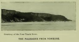
Names on the East from Manhattan North.
Keskeskick, "a piece of land, situated opposite to the flat on the island of Manhattan, called Keskeskick, stretching lengthwise along the Kil which runs behind the island of Manhattan, beginning at the head of said Kil and running to opposite of the high hill by the flat, namely by the great hill," (Deed of 1638.) Kaxkeek is the orthography of Riker (Hist. of Harlem); and Kekesick that of Brodhead (Hist. New York), in addition to which may be quoted Keesick and Keakates, given as the names of what is now known as Long Pond, which formed the southeast boundary of the tract, where was also a salt marsh or meadow. In general terms, the name means a "meadow," and may have been that of this salt marsh (a portion of the name dropped) or of the flat. The root is Kâk, "sharp;" Kâkákes, "sharp grass," or sedge-marsh; Sik-kákaskeg, "salt sedge-marsh." (Gerard.) Micûckaskéete, "a meadow." (Williams.) Muscota, now in use, is another word for meadow.
Mannepies is quoted by Riker (Hist. Harlem) as the name of the hilly tract or district of Keskeskick, described as lying "over against the flats of the island of Manhattan." It is now preserved as the name of Cromwell Lake and creek, and seems to have been the name of the former. The original was probably an equivalent of Menuppek, "Any enclosed body of water great or small." (Anthony.)
Neperah, Nippiroha, Niperan, Nepeehen, Napperhaera, Armepperahin, the latter of date 1642 (Col. Hist. N. Y., xiii, 9), forms of record as the name of Sawmill Creek, and also quoted as the name of the site of the present city of Yonkers, has been translated by Wm. R. Gerard, from the form of 1642: "A corruption of Ana-nepeheren, that is, 'fishing stream' or 'fishing rapids.'" Ap-pehan (Eliot), "a trap, a snare." There was an Indian village on the north side of the stream in 1642. (Col. Hist. N. Y., xiii, 9.)
Nepahkomuk, Nappikomack, etc., quoted as the name of a place on Sawmill Creek, and also as the name of an Indian village at Yonkers, may have been the name of the latter by extension. It has been translated with apparent correctness from Nepé-komuk (Mass.), "An enclosed or occupied water-place." [FN]
[FN] This translation is from Nepe (Nepa, Nape, Nippe, etc.), meaning "water," generally, and Komuk, "place enclosed, occupied, limited," a particular body of water. "The radical of Nipe is pe or pa, which, with the demonstrative and definitive ne prefixed, formed the noun nippe, water." (Trumbull.) Nape-ake (-auke, -aki) means "Water-land," or water-place. Nape-ek, Del., Nepeauk, Mass., means "Standing water," a lake or pond or a stretch of still water in a river. Menuppek, "Lake, sea, any enclosed body of water, great or small." (Anthony.) Nebi, nabe, m'bi, be, are dialectic forms. The Delaware M'hi (Zeisb.) is occasionally met in the valley, but the Massachusetts Nepe is more frequent. Gami is another noun-generic meaning "Water" (Cree, Kume). Komuk (Mass.), Kamick (Del.), is frequently met in varying orthographies. In general terms it means "Place, limited or enclosed," a particular place as a field, garden, house, etc., as distinguished from auke, "Land, earth, unlimited, unenclosed."
Meghkeekassin, the name of a large rock in an obscure nook on the west side of the Neperah, near the Hudson, is written Macackassin in deed of 1661. It is from Mechek, Del., "great," and assin "stone." "Meechek-assin-ik, At the big rock." (Heckewelder.) The name is also of record Amack-assin, a Delaware term of the same general meaning—"Amangi, great, big (in composition Aman-gach), with the accessory notion of terrible, frightful." (Dr. Brinton.) Presumably, in application here, "a monster," i. e. a stone not of the native formation usually found in the locality. [FN]
[FN] The Indians are traditionally represented as regarding boulders of this class, as monuments of a great battle which was fought between their hero myth Micabo and Kasbun his twin brother, the former representing the East or Orient, and the latter the West, the imagery being a description of the primary contest between Light and Darkness—Light gleaming from the East and Darkness retreating to the West before it. Says the story: "The feud between the brothers was bitter and the contest long and doubtful. It began on the mountains of the East. The face of the land was seamed and torn by the wrestling of the mighty combatants, and the huge boulders that are scattered about were the weapons hurled at each other by the enraged brothers." The story is told in its several forms by Dr. Brinton in his "American Hero Myths."
Wickquaskeck is entered on Van der Donck's map as the name of an Indian village or castle the location of which is claimed by Bolton to have been at Dobb's Ferry, where the name is of record. It was, however, the name of a place from which it was extended by the early Dutch to a very considerable representative clan or family of Indians whose jurisdiction extended from the Hudson to or beyond the Armonck or Byram's River, with principal seat on the head waters of that stream, or on one of its tributaries, who constituted the tribe more especially known to the Dutch settlers as the Manhattans. Cornelius Tienhoven, Secretary of New Amsterdam, wrote, in 1654, "Wicquaeskeck on the North River, five miles above New Amsterdam, is very good and suitable land for agriculture. . . . This land lies between the Sintsinck and Armonck streams, situate between the East and North rivers." (Doc. Hist, N. Y., iv, 29.) "Five miles," Dutch, was then usually counted as twenty miles (English). Standard Dutch miles would be about eighteen. The Armonck is now called Byram River; it flows to the Sound on the boundary line between New York and Connecticut. A part of the territory of this tribe is loosely described in a deed of 1682, as extending—"from the rock Sighes, on Hudson's River, to the Neperah, and thence north until you come to the eastward of the head of the creek, called by the Indians Wiequaskeck, [FN] stretching through the woods to a kill called Seweruc," including "a piece of land about Wighqueskeck," i. e. about the head of the creek, which was certainly at the end of a swamp. The historic seat of the clan was in this vicinity. In the narrative of the war of 1643-5, it is written, "He of Witqueschreek, living N. E. of Manhattans. . . . The old Indian (a captive) promised to lead us to Wetquescheck." He did so, but the castles, three in number, strongly palisaded, were found empty. Two of them were burned. The inmates, it was learned, had gathered at a large castle or village on Patucquapaug, now known as Dumpling Pond, in Greenwich, Ct., to celebrate a festival. They were attacked there and slaughtered in great numbers. (Doc. Hist. N. Y., iv, 29.) Bolton's claim that the clan had a castle at or near Dobb's Ferry, may have been true at some date. The name appears in many orthographies; in 1621, Wyeck; in treaty of 1645, Wiquaeshex; in other connections, Witqueschreek, Weaquassick, and Van der Donck's Wickquaskeek. Bolton translated it from the form, Weicquasguck, "Place of the bark kettle," which is obviously erroneous. Dr. Trumbull wrote: "From Moh. Weegasoeguck, 'the end of the marsh or wet meadow.'" Van der Donck's Wickquaskeck has the same meaning. It is from Lenape Wicqua-askek—wicqua, "end of," askek, "swamp," marsh, etc.: -ck,-eck, formative.
[FN] The creek now bearing the name flows to the Hudson through the village of Dobb's Ferry. Its local name, "Wicker's creek," is a corruption of Wickquaskeek. It was never the name of an individual.
Pocanteco, Pecantico, Puegkandico and Perghanduck, a stream so called [FN-1] in Westchester County, was translated by Dr. O'Callaghan from Pohkunni, "Dark." "The dark river," and by Bolton from Pockawachne, "A stream between hills," which is certainly erroneous. The first word is probably Pohk or Pak, root Paken (Pákenum, "Dark," Zeisb.; Pohken-ahtu, "In darkness," Eliot). The second may stand for antakeu, "Woods," "Forest," and the combination read "The Dark Woods." The stream rises in New Castle township and flows across the town of Mt. Pleasant to the Hudson at Tarrytown, where it is associated with Irving's story of Sleepy Hollow. The Dutch called it "Sleeper's-haven Kil," from the name which they gave to the reach on the Hudson, "Verdrietig Hoek," or "Tedious Point," because the hook or point was so long in sight of their slow-sailing vessels, and in calms their crews slept away the hours under its shadows, "Over against the Verdrietig Hoek, commonly called by the name of Sleeper's Haven," is the record. Pocanteco was a heavily wooded valley, and suggested to the early mothers stories of ghosts to keep their children from wandering in its depths. From the woods or the valley the name was extended to the stream.[FN-2] (See Alipkonck.)
[FN-1] December 1st, 1680, Frederick Phillips petitioned for liberty to purchase "a parcel of land on each side of the creek called by the Indians Pocanteco, . . . adjoining the land he hath already purchased; there to build and erect a saw-mill." (Col. Hist. N. Y., xiii, 546.)
[FN-2] "Far in the foldings of the hills winds this wizard stream—sometimes silently and darkly through solemn woodlands. . . . In the neighborhood of the aqueduct is a deep ravine which forms the dreamy region of Sleepy Hollow." (Sketch Book.)
Alipkonck is entered on Van der Donck's map of 1656, and located with the sign of an Indian village south of Sing Sing. Bolton (Hist. West. Co.) claimed it as the name of Tarrytown, and translated it, "The place of elms," which it certainly does not mean. Its derivative, however, is disguised in its orthography, and its locative is not certain. Conjecturally Alipk is from Wálagk (surd mutes g and p exchanged), "An open place, a hollow or excavation." The locative may have been Sleepy Hollow. Tarrytown, which some writers have derived from Tarwe (Dutch), "Wheat"—Wheat town—proves to be from an early settler whose name was Terry, pronounced Tarry, as written in early records. The Dutch name for Wheat town would be Tarwe-stadt, which was never written here.
Oscawanna, an island so called, lying a short distance south of Cruger's Station on N. Y. Central R. R., Hudson River Division, is of record, in 1690, Wuscawanus. (Doc. Hist. N. Y., ii, 237.) It seems to have been from the name of a sachem, otherwise known as Weskora, Weskheun, Weskomen, in 1685. Wuski, Len., "New, young;" Wuske'éne Williams, "A youth."
Shildrake, or Sheldrake, given as the name of Furnace Brook, takes that name from an extended forest known in local records as "The Furnace Woods." By exchange of l and n, it is probably from Schind, "Spruce-pine" (Zeisb.); aki, "Land" or place. Schindikeu, "Spruce forest" ("Hemlock woods," Anthony). (See Shinnec'ock.) Furnace Brook takes that name from an ancient furnace on its bank. In 1734 it was known as "The old-mill stream." Jamawissa, quoted as its Indian name, seems to be an aspirated form of Tamaquese, "Small beaver." (See Jamaica.)
Sing-Sing—Sinsing, Van der Donck; Sintsing, treaty of 1645—usually translated, "At the standing-stone," and "Stone upon stone," means "At the small stones," or "Place of small stones"—from assin "stone;" is, diminutive, and ing, locative. Ossinsing, the name of the town, has the same meaning; also, Sink-sink, L. I., ind Assinising, Chemung County. The interpretation is literally sustained in the locative on the Hudson.
Tuckahoe, town of East Chester, is from Ptuckweōō, "It is round." It was the name of a bulbous root which was used by the Indians for food and for making bread, or round loaves. (See Tuckahoe, L. I.)
Kitchiwan, modern form; Kitchawanc, treaty of 1643; Kichtawanghs, treaty of 1645; Kitchiwan, deed of 1645; Kitchawan, treaty of 1664; the name of a stream in Westchester County from which extended to an Indian clan, "Is," writes Dr. Albert S. Gatschet of the Bureau of Ethnology, "an equivalent of Wabenaki-ke'dshwan, -kidshuan, suffixed verbal stem, meaning 'Running Swiftly,' 'Rushing water,' or current, whether over rapids or not. Sas-katchéwan, Canada, 'The roiley, rushing stream'; assisku, 'Mud, dirt.' (Cree.) The prefix ki or ke, is nothing else than an abbreviation of kitchi, 'great,' 'large,' and here 'strong.' Examples are frequent as -kitchuan, -kitchawan, Mass.; kesi-itsooaⁿn or taⁿn, Abn., Kussi-tchuan, Mass., 'It swift flows.' The prefix is usually applied to streams which rise in the highlands and flow down rapidly descending slopes." The final k in some of the early forms, indicates pronunciation with the guttural aspirate, as met in wank and wangh in other local names. [FN] The final s is a foreign plural usually employed to express "people," or tribe. The stream is now known as the Croten from Cnoten, the name of a resident sachem, which by exchange of n and r, becomes Croten, an equivalent, wrote Dr. Schoolcraft of Noten, Chip., "The wind." "Bounded on the south by Scroton's River" (deed of 1703); "Called by the Indians Kightawank, and by the English Knotrus River." (Col. N. Y, Land Papers, 79.)
[FN] Dr. Trumbull wrote in the Natick (Mass.) dialect, "Kussitchuan, -uwan, impersonal verb, 'It flows in a rapid stream,' a current; it continues flowing; as a noun, 'a rapid stream.'" In Cree, Kussehtanne, "Flowing as a stream" In Delaware, -tanne has its equivalent in -hanne. "The impersonal verb termination -awan, -uan, etc., is sometimes written with the participial and subjunctive k" (ka or gh.) (Gerard.) The k or gh appears in some forms of Kitchawan. (See Waronawanka.)
Titicus, given as the name of a branch of the Croton flowing from Connecticut, is of record Mutighticos and Matightekonks, translated by Dr. Trumbull from Mat'uhtugh-ohke, "Place without wood," from which extended to the stream. (See Mattituck and Sackonck.)
Navish is claimed as the name of Teller's (now Croton) Point, on a reading of the Indian deed of 1683: "All that parcel, neck or point of land, with the meadow ground or valley adjoining, situate, lying and being on the east side of the river over against Verdrietig's Hooke, commonly called and known by the name of Slauper's Haven and by the Indians Navish, the meadow being called by the Indians Senasqua." Clearly, Navish refers to Verdrietig Hook, on the west side of the river, where it is of record. It is an equivalent of Newás (Len.), "promontory." (See Nyack-on-the-Hudson.)
Nannakans, given as the name of a clan residing on Croton River, is an equivalent of Narragans (s foreign plural), meaning "People of the point," the locative being Croton Point. (See Nyack.) This clan, crushed by the war of 1643-5, removed to the Raritan country, where, by dialectic exchange of n and r, they were known as Raritanoos, or Narritans. They were represented, in 1649, by Pennekeck, "The chief behind the Kul, having no chief of their own." (Col. Hist. N. Y., xiii.) The interpretation given to their removal, by some writers, viz., "That the Wappingers removed to New Jersey," is only correct in a limited sense. The removal was of a single clan or family. The Indians on both sides of the Hudson here were of kindred stock and were largely intermarried. (See Raritans and Pomptons.)
Senasqua, quoted as the name of Teller's Point (now Croton Point), and also as the name of Teller's Neck, is described as "A meadow," presumably on the neck or point. It is an equivalent of Del. Lenaskqual, "Original grass," (Zeisb.), i. e. grass which was supposed to have grown on the land from the beginning. (Heck.) Called "Indian grass" to distinguish it from "Whitemen's grass." [FN]
[FN] Askquall, or Askqua, is an inanimate plural in the termination -all, -al, or -a. All grass was not described by Maskik, in which the termination -ik is the animate plural.
Peppeneghek is a record form of the name quoted as that of what is now known as Cross-river.
Kewighecack, the name of a boundmark of Van Cortlandt's Manor, is written on the map of the Manor Keweghteuack as the name of a bend in the Croton west of Pine Bridge. It is from Koua, Kowa, Cuwé, "Pine"—Cuwé-uchac, "Pine wood, pine logs." (Zeisb.)
Kestaubniuk is entered on Van der Donck's map as the name of an Indian place or village north of Sing Sing. On Vischer's map the orthography is Kestaubocuck. Dr. Schoolcraft wrote Kestoniuck, "Great Point," and claimed that the last word had been borrowed and applied to Nyack on the opposite side of the river, but this is a mistake as Nyack is generic and of local record where it now is as early as 1660, and is there correctly applied. No one seems to know where Kestaubniuk was, but the name is obviously from Kitschi-bonok, "Great ground-nut place." Ketche-punak and Ketcha-bonac, L. I., K'schobbenak, Del.
Menagh, entered in Indian deed to Van Cortlandt, 1683, as the name of what is now known as Verplanck's Point, is probably from Menach'en (Del.), the indefinite form of Menátes, diminutive, meaning "Small island." The point was an island in its separation from the main land by a water course. Monack, Monach, Menach, are other orthographies of the name.
Tammoesis is of record as the name of a small stream north of Peekskill.
Appamaghpogh, now Amawalk, seems to have been extended to a tract of land without specific location. It is presumed to have been the name of a fishing place on what is now known as Mohegan Lake Appéh-ama-paug, "Trap fishing place," or pond. Amawalk, is from Nam'e-auke, "Fishing-place," (Trumbull.) In the Massachusetts dialect -pogh stands for "pond," or water-place.
Keskistkonck, Pasquasheck, and Nochpeem are noted on Van der Donck's map in the Highlands. In Colonial History is the entry (1644), "Mongochkonnome and Papenaharrow, chiefs of Wiquseskkack and Nochpeems." On the east side of the river, apparently about opposite the Donderberg, is located, on early maps, the Pachimi, who, in turn, are associated in records with the Tankitekes. Pacham is given as the name of a noted chief of the early period. His clan was probably the Pachimi. Keskistkonck was a living name as late as 1663, but disappears after that date. "The Kiskightkoncks, who have no chief now, but are counted among the foregoing savages." (Col. Hist. N. Y., xiii, 303.)
Sachus, Sachoes and Sackoack are quoted as names of Peekskill, and Magrigaries as the name of the stream. The latter is an orthography of MacGregorie's, from Hugh MacGregorie, an owner of lands on the stream. [FN-1] Though quoted as the name of Peak's Kill, it was the name given to a small creek south of that stream, as per map of 1776. Sachus and Sachoes are equivalents, and probably refer to the mouth or outlet of the small or MacGregorie's Creek—Sakoes or Saukoes. Sackonck has substantially the same meaning—Sakunk, "At the mouth or outlet of a creek or river." There was, however, a resident sachem who was called Sachoes, probably from his place of residence, but which can be read "Black Kettle," from Suckeu, "black," and ōōs, "kettle." Peekskill is modern from Peak's Kill, so called from Jan Peak, [FN-2] the founder of the settlement. The Indian name of the stream is noted, in deed of 1695, "Called by the Indians Paquintuk," probably an equivalent of Pokqueantuk, "A broad, open place in a tidal river or estuary." Peekskill Bay was probably referred to. (See Sackonck.)
[FN-1] Hugh MacGregorie was son of Major Patrick MacGregorie, the first settler in the present county of Orange. He was killed in the Leisler rebellion in New York in 1691. The son, Hugh, and his mother, were granted 1500 acres of land "At a place called John Peaches creek." No fees were charged for the patent out of respect for the memory of Major MacGregorie, as he then had "lately died in His Majesty's service in defence of the Province." (Doc. Hist. N. Y., ii, 364.) MacGregories sold to Van Cortlandt in 1696.
[FN-2] Peake, an orthography of Peak, English; Dutch, Piek; pronounced Pek (e as e in wet); English, Pek or Peck.
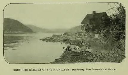
Kittatinny, erroneously claimed to mean "Endless hills," and to describe the Highlands as a continuation of the Allegheny range, belongs to Anthony's Nose [FN-1] to which, however, it has no very early record application. It is from Kitschi, "Principal, greatest," and -atinny, "Hill, mountain," applicable to any principal mountain peak compared with others in its vicinity. [FN-2]
[FN-1] The origin of the name is uncertain. Estevan Gomez, a Spanish navigator, wrote "St. Anthony's River" as the name of the Hudson, in 1525. The current explanation, "Antonius Neus, so called from fancied resemblance to the nose of one Anthony de Hoages," is a myth. The name as the early Dutch understood it, is no doubt more correctly explained by Jasper Bankers and Peter Sluyter in their Journal of 1679-80: "A headland and high hill in the Highlands, so called because it has a sharp ridge running up and down in the form of a nose," but fails to explain St. Anthony, or Latin Antonius. The name appears also on the Mohawk river and on Lake George, presumably from resemblance to the Highland peak.
[FN-2] The Indians had no names for mountain ranges, but frequently designated certain peaks by specific names. "Among these aboriginal people," wrote Heckewelder, "every tree was not the tree, and every mountain the mountain; but, on the contrary, everything is distinguished by its specific name." Kittatinny was and is the most conspicuous or greatest hill of the particular group of hills in its proximity and was spoken of as such in designating the boundmark.
Sacrahung, or Mill River, "takes its name from Sacra, 'rain.' Its liability to freshets after heavy rains, may have given origin to the name." (O'Callaghan.) Evidently, however, the name is a corruption of Sakwihung (Zeish.), "At the mouth of the river." The record reads, "A small brook or run called Wigwam brook, but by some falsely called Sackwrahung." (Deed of 1740.)
Quinnehung, a neck of land at the mouth and west side of Bronx River, is presumed to have been the name of Hunter's Point. The adjectival Quinneh, is very plainly an equivalent of Quinnih (Eliot), "long," and -ung or -ongh may stand for place—"A long place, or neck of land." (See Aquchung.)
Sackonck and Matightekonck, record names of places petitioned for by Van Cortlandt in 1697, are located in general terms, in the petition, in the neighborhood of John Peak's Creek and Anthony's Nose. (Cal. N. Y. Land Papers, 49.) The first probably referred to the mouth of Peak's Creek (Peekskill). Sakunk (Heck.), "At the mouth or outlet of a creek or river." Saukunk (Donck) is another form. (See Titicus.)
Aquehung, Acqueahounck, etc., was translated by Dr. O'Callaghan, "The place of peace." from Aquene, Nar., "peace," and unk, locative. Dr. Trumbull wrote, "A place on this side of some other place," from the generic Acq. The description in N. Y. Land Papers reads, "Bounded on the east by the river called by the Indians Aquehung," the river taking its name from its position as a boundary "on this side" of which was the land. The contemporary name, Ran-ahqua-ung, means "A place on the other side," corresponding with the description, "On the other side of the Great Kil." Bolton assigns Acqueahounck to Hutchinson's Creek, the west boundary of the town of Pelham. The "Great Kil" is now the Bronx.
Kakeout, the name of the highest hill in Westchester County, is from Dutch Kijk-uit, "Look-out—a place of observation, as a tower, hill," etc. It appears also in Rockland and in Ulster County and on the Mohawk. (See Kakiate.)
Shappequa, a name now applied to the Shappequa Hills and to a mineral spring east of Sing-Sing, and destined to be remembered as that of the home of Horace Greeley, was primarily given to locate a tract now embraced in the towns of New Castle and Bedford, and, as in all such cases, was a specific place by which the location could be identified, but which in turn has never been identified. The name is apparently a form of Chepi written also Chappa, signifying, "Separated, apart from, a distinct place." [FN] (See Kap-hack.)
[FN] The word Chippe or Shappa, means not only separate, "The separate place," but was employed to describe a future condition—Chepeck, the dead. As an adjective, Chippe (El.) signifies separated, set apart. Chepiohkomuk, the place of separation. The same word was used for 'ghost,' 'spectre,' 'evil spirit.' (Trumbull.) The corresponding Delaware word was Tschipey. It is not presumed that the word was made use of here in any other sense than its literal application, "A separate place." Bolton assigns the name to a Laurel Swamp, but with doubtful correctness.
Aspetong, a bold eminence in Bedford, is an equivalent of Ashpohtag, Mass., "A high place," "A height." (Trumbull.) See Ishpatinau.
Quarepos, of record as the name of the district of country called by the English "White Plains," from the primary prevalence there of white balsam (Dr. O'Callaghan), seems to have been the name of the lake now known as St. Mary's. Quar is a form of Quin, Quan, etc., meaning "Long," and pos stands for pog or paug, meaning "Pond." The name is met in Quin'e-paug, "Long Pond." The pond lies along the east border of the town of White Plains.
Peningo, the point or neck of land forming the southeastern extremity of the town of Rye, [FN] was interpreted by Dr. Bolton, with doubtful correctness: "From Ponus, an Indian chief." The neck is some nine miles long by about two miles broad and seems to have been primarily a region of ridges and swamps.
[FN] Rye is from Rye, England. The derivative is Ripe (Latin), meaning, "The bank of a river." In French, "The sea-shore."
Apanammis, Cal. N. Y, Land Papers; Apauamis and Apauamin, Col. Hist. N. Y.: Apawammeis, Apawamis, Apawqunamis, Epawames, local and Conn. Records, is given as the name of Budd's Neck, between Mamaroneck River and Blind Brook, Westchester County. Dr. Trumbull passed the name without explanation. It is written as the name of a boundmark.
Mochquams and Moagunanes are record forms of the name of Blind Brook, one of the boundary streams of the tract called Penningo, which is described as lying "between Blind Brook and Byram River." (See Armonck.)
Magopson and Mangopson are orthographies of the name given as that of De Lancey's Neck, described as "The great neck." (See Waumaniuck.) The dialect spoken in eastern Westchester seems to have been Quiripi (or Quinipiac), which prevailed near the Sound from New Haven west.
Armonck, claimed as the name of Byram's River, was probably that of a fishing place. In 1649 the name of the stream is of record, "Called by the Indians Seweyruck." In the same record the land is called Haseco and a meadow Misosehasakey, interpreted by Dr. Trumbull, "Great fresh meadow," or low wet lands. Haseco has no meaning; it is now assigned to Port Chester (Saw-Pits), and Misosehasakey to Horse Neck. Armonck has lost some of its letters. What is left of it indicates Amaug, "fishing place." (Trumbull's Indian Names.)
Eauketaupucason, the name written as that of the feature in the village of Rye known by the unpleasant English title of "Hog-pen Ridge," is, writes Mr. William R. Gerard, "Probably an equivalent of Lenape Ogid-ápuchk-essen, meaning, 'There is rock upon rock,' or one rock on another rock." Topography not ascertained.
Manussing—in will of Joseph Sherwood, Menassink—an island so called in the jurisdiction of Rye, may be an equivalent of Min-assin-ink, "At a place of small stones," Minneweis, now City Island, is in the same jurisdiction.
Mamaroneck, now so written as the name of a town in Westchester County, is of record, in 1644, Mamarrack and Mamarranack; later, Mammaranock, Mamorinack, Mammarinickes (1662), primarily as that of a "Neck or parcel of land," but claimed to be from the name of an early sachem of the Kitchtawanks whose territory was called Kitchtawanuck. [FN] Wm. R. Gerard explains: "The dissyllabic root, mamal, or mamar, means 'To stripe;' Mamar-a-nak, 'striped arms,' or eyebrows, as the name of an Indian chief who painted his arms in stripes or radiated his eyebrows," a custom noted by several early writers. There is no evidence that the Kitchtawanuck sachem had either residence or jurisdiction here, nor is his name signed to any deed in this district. The reading in one record, "Three stripes or strips of land," seems to indicate that the name was descriptive of the necks or strips of land. (See Waumaniuck.)
[FN] "Mamarranack and Waupaurin, chiefs of Kitchawanuck." (Col. Hist. N. Y., xiii, 17.) The Kitchawan is now known as Croton river. It has no connection whatever with Mamaroneck.
Waumaniuck and Maumaniuck, forms of the name of record as that of the eastern part of De Lancey's Neck, or Seaman's Point, Westchester County, as stated in the Indian deed of 1661, which conveyed to one John Richbell "three necks of land," described as "Bounded on the east by Mamaroneck River, and on the west by Gravelly or Stony Brook" (Cal. N. Y. Land Papers, 5), the latter by the Indians called Pockotesse-wacke, came to be known as Mamaraneck Neck, otherwise described as "The great neck of land at Mamaroneck."
Pockotessewacke, given as the name of what came to be known as "Gravelly or Stony Brook," and "Beaver-meadow Brook," [FN] has been translated by Wm. R. Gerard, from "Petuk-assin-icke, 'where there are numerous round stones'"; a place from which the name was extended to the stream, or the name of a place in the stream where there were numerous round stones, i. e. paving stones or "hard-heads." Esse (esseni) from assin, "stone," means "stony, flinty."
[FN] Pockotessewacke and Beaver-meadow Brook. (Cal. N. Y. Land Papers.)
Manuketesuck, quoted by Bolton (Hist. West. Co.) as the name of Long Island Sound and interpreted, "Broad flowing river," was more correctly explained by Dr. Trumbull: "Apparently a diminutive of Manunkatesuck, 'Menhaden country,' from Munongutteau, 'that which fertalizes or manures land,' the Indian name for white fish or bony fish, which were taken in great numbers by the Indians, on the shores of the Sound, for manuring their corn lands."
Moharsic is said to have been the name of what is now known as Crom-pond, in the town of Yorktown. The pond is in two parts, and the name may mean, "Where two ponds meet," or come together. Crom-pond is corrupt Dutch from Krom-poel, "Crooked pond."
Maharness, the name of a stream rising in Westchester County and flowing east to the Sound, is also written Mianus and Mahanus, in Dutch records Mayane, correctly Mayanno. It was the name of "a sachem residing on it between Greenwich and Stamford, Ct., who was killed by Capt. Patrick, in 1643, and his head cut off and sent to Fort Amsterdam." (Brodhead, i, 386.) Dr. Trumbull interpreted, "He who gathers together." Kechkawes is written as the name of the stream in 1640.
Nanichiestawack, given as the name of an Indian village on the southern spur of Indian Hill (so called) in the town of Bedford, rests on tradition.
Petuckquapaug, a pond in Greenwich, Ct., but originally under the jurisdiction of the Dutch at Fort Amsterdam, signifies "Round Pond." It is now called "Dumpling Pond." The Dutch changed the suffix to paen, "soft land," and in that form described an adjacent district of low land. (See Tappan.)
Katonah, the name of a sachem, is preserved in that of a village in the town of Bedford. The district was known as "Katonah's land." In deed of 1680, the orthography is Katōōnah—oo as in food.
Succabonk, a place-name in the town of Bedford, stands for Sagabonak-ong, "Place of ground nuts," or wild potatoes. (See Sagabonock.)
Wequehackhe is written by Reichel ("Mem. Moravian Church") as the name of the Highlands, with the interpretation, "The hill country"—"People of the hill country." The name has no such meaning. Weque or Wequa, means "The end," and -hackhe (hacki) means "Land," not up-land. In other words, the boundary was the end of the Highlands.' [FN]
[FN] "Hacki, land; Len-hacki, up-land." (Zeisberger.) "When they speak of highlands they say Lennihacke, original lands; but they do not apply the same name to low lands, which, being generally formed by the overflowing or washing of streams, cannot be called original." (Heckewelder.)
Mahopack, the modern form of the name of a lake in Putnam County, is of record Makoohpeck in 1765, and Macookpack on Sauthier's map of 1774, which seem to stand for M'achkookpéeck (Ukh-okpeck, Mah.), meaning "Snake Lake," or "Water where snakes are abundant." (See Copake.) In early years snakes were abundant in the region about the lake, and are not scarce in present times. [FN] The lake is ten miles in circumference and lies sixteen hundred feet above the level of Hudson's River. It contains two or three small islands, on the largest of which is the traditionally famous "Chieftain's Rock."
[FN] A wild, wet region among the hills, where the rattlesnake abounded. They were formerly found in all parts of the Highlands, and are still met frequently.
Canopus, claimed to have been the name of an Indian sachem and now preserved in Canopus Hollow, Putnam County, is not Indian; it is Latin from the Greek name of a town in Egypt. "Can'pus, the Egyptian god of water." (Webster.)
Wiccopee is of record as the name of the highest peak in the Fishkill Mountains on the south border of East Fishkill. It is also assigned to the pass or clove in the range through which ran the Indian path, now the present as well as the ancient highway between Fishkill Village and Peekskill, which was fortified in the war of the Revolution. An Indian village is traditionally located in the pass, of which "one Wikopy" is named as chief on the same authority. The name, however, has no reference to a pass, path, village or chief; it is a pronunciation of Wecuppe, "The place of basswoods or linden trees," from the inner bark of which (wikopi) "the Indians made ropes and mats—their tying bark par excellence." (Trumbull.) "Wikbi, bast, the inner bark of trees." (Zeisberger.) In Webster and The Century the name is applied to the Leather-wood, a willowy shrub with a tough, leathery bark.
Matteawan, now so written, has retained that orthography since its first appearance in 1685 in the Rombout Patent, which reads: "Beginning on the south side of a creek called Matteawan," the exact boundmark being the north side or foot of the hill known as Breakneck (Matomps'k). It has been interpreted in various ways, that most frequently quoted appearing in Spofford's Gazetteer: "From Matai, a magician, and Wian, a skin; freely rendered, 'Place of good furs,'" which never could have been the meaning; nor does the name refer to mountains to which it has been extended. Wm. R. Gerard writes: "Matáwan, an impersonal Algonquian verb, meaning, 'It debouches into,' i. e. 'a creek or river into another body of water,' substantially, 'a confluence.'" This rendering is confirmed by Albert S. Gatschet, of the Bureau of Ethnology, who writes: "Mr. Gerard is certainly right when he explains the radix mat—mata—by confluence, junction, debouching, and forming verbs as well as roots and nouns." -A'wan, -wan -uan, etc., is an impersonal verb termination; it appears only in connection with impersonal verbs. (See Waronawanka.) Matteawan is met in several forms—Matawa and Mattawan, Ontario, Canada; Mattawan, Maine; Matawan, Monmouth County, N. J.; Mattawanna, Pa.; Mattawoman, Maryland.
Fishkill, the English name of the stream of which Matteawan is the estuary, is from Dutch Vischer's Kil. It was probably applied by the Dutch to the estuary from Vischer's Rak which the Dutch applied to a reach or sailing course on the Hudson at this point. De Laet wrote: "A place which our country-men call Vischer's Rack, [FN] that is Fisherman's Bend." (See Woranecks.) On the earlier maps the stream, or its estuary, is named Vresch Kil, or "Fresh-water Kil," to distinguish it from the brackish water of the Hudson. From the estuary extended to the entire stream.
[FN] Rack is obsolete; the present word is Recht. It describes an almost straight part of the river.
Woranecks, Carte Figurative 1614-16; Waoranecks, 1621-25; Warenecker, Wassenaer; Waoranekye, De Laet, 1633-40; Waoranecks, Van der Donck's map, 1656—is located on the Carte Figurative north of latitude 42-15, on the east side of the river. De Laet and Van der Donck place it between what are now known as Wappingers' Creek and Fishkill Creek. De Laet wrote: "Where projects a sandy point and the river becomes narrower, there is a place called Esopus, where the Waoranekys, another barbarous nation, have their abode." Later, Esopus became permanent on the west side of the river at Kingston. It is a Dutch corruption of Algonquian Sepus, meaning brook, creek, etc., applicable to any small stream. From De Laet's description, [FN] there is little room for doubt that the "sandy point" to which he referred is now known as Low Point, opposite the Dans Kamer, at the head of Newburgh Bay, where the river narrows, or that Esopus was applied to Casper's Creek. On Van der Donck's map the "barbarous nation" is given three castles on the south side of the stream, which became known later (1643) as the Wappingers, who certainly held jurisdiction on the east side of Newburgh Bay. The adjectival of the name is no doubt from Wáro, or Waloh, meaning "Concave, hollowing," a depression in land, low land, the latter expressed in ock (ohke), "land" or place. The same adjectival appears in Waronawanka at Kingston, and the same word in Woronake on the Sound at Milford, Ct., where the topography is similar. The foreign plural s extends the meaning to "Dwellers on," or inhabitants of. (See Wahamenesing and {Waro?}nawanka.)
[FN] . . . "And thus with various windings it reaches a place which our countrymen call Vischer's Rack, that is the Fisherman's Bend. And here the eastern bank is inhabited by the Pachimi. A little beyond where projects a sandy point and the river becomes narrower, there is a place called Esopus, where the Waoranekys, another barbarous nation, have their abode. To these succeed, after a short interval, the Waranawankconghs, on the opposite side of the river." (De Laet.)
"At the Fisher's Hook are the Pachany, Wareneckers," etc. (Wassenaer.)
Mawenawasigh, so written in the Rombout Patent of 1684, covering lands extending from Wappingers' Creek to the foot of the hills on the north side of Matteawan Creek, was the name of the north boundmark of the patent and not that of Wappingers' Creek. The Indian deed reads: "Beginning on the south side of a creek called Matteawan, from thence northwardly along Hudson's river five hundred yards beyond the Great Wappingers creek or kill, called Mawenawasigh." The stream was given the name of the boundmark and was introduced to identify the place that was five hundred yards north of it, i. e. the rocky point or promontory through which passes the tunnel of the Hudson River R. R. at New Hamburgh. The name is from Mawe, "To meet," and Newásek, [FN] "A point or promontory"—literally, "The promontory where another boundary is met." The assignment of the name to Wappingers' Falls is as erroneous as its assignment to the creek.
[FN] Nawaas, on the Connecticut, noted on the Carte Figurative of 1614-16, is very distinctly located at a point on the head-waters of that river.
Neversink is a corruption of Newas-ink, "At the point or promontory."
Wahamanesing is noted by Brodhead (Hist. N. Y.) as the name of Wappingers' Creek—authority not cited and place where the stream was so called not ascertained. The initial W was probably exchanged for M by mishearing, as it was in many cases of record. Mah means "To meet," Amhannes means "A small river," and the suffix -ing is locative. The composition reads: "A place where streams come together," which may have been on the Hudson at the mouth of the creek. In Philadelphia Moyamansing was the name of a marsh bounded by four small streams. (N. Y. Land Papers, 646.) Dr. Trumbull in his "Indian Names on the Connecticut," quoted Mahmansuck (Moh.), in Connecticut, with the explanation, "Where two streams come together." The name was extended to the creek as customary in such cases. The Wahamanesing flows from Stissing Pond, in northern Duchess County, and follows the center of a narrow belt of limestone its entire length of about thirty-five miles southwest to the Hudson, which it reaches in a curve and passes over a picturesque fall of seventy-five feet to an estuary. From early Dutch occupation it has been known or called Wappinck (1645), Wappinges and Wappingers' Kill or creek, taking that name presumably from the clan which was seated upon it of record as "Wappings, Wappinges, Wapans, or Highland Indians." [FN-1] On Van der Donck's map three castles or villages of the clan are located on the south side or south of the creek, indicating the inclusion in the tribal jurisdiction of the lands as far south as the Highlands. From Kregier's Journal of the "Second Esopus War" (1663), it is learned that they had a principal castle in the vicinity of Low Point and that they maintained a crossing-place to Dans Kamer Point. Their name is presumed to have been derived from generic Wapan, "East"—Wapani, "Eastern people" [FN-2]—which could have been properly applied to them as residents on the east side of the river, not "Eastern people" as that term is applied to residents of the more Eastern States, but locally so called by residents on the west side of the Hudson, or by the Delawares as the most eastern nation of their own stock. They were no doubt more or less mixed by association and marriage with their eastern as well as their western neighbors, but were primarily of Lenape or Delaware origin, and related to the Minsi, Monsey or Minisink clans on the west side of the river, though not associated with them in tribal government. [FN-3] Their tribal jurisdiction, aside from that which was immediately local, extended on the east side of the river from Roelof Jansen's Kill (south of opposite to the Catskill) to the sea. At their northern bound they met the tribe known to the Dutch as the Mahicans, a people of eastern origin and dialect, whose eastern limit included the valley of the Housatonic at least, and with them in alliance formed the "Mahican nation" of Dutch history, as stated by King Ninham of the Wappingers, in an affidavit in 1757, and who also stated that the language of the Mahicans was not the same as that of the Wappingers, although he understood the Mahicani. Reduced by early wars with the Dutch around New Amsterdam and by contact with European civilization, they melted away rapidly, many of them finding homes in New Jersey and Pennsylvania, others at Stockbridge, and a remnant living at Fishkill removing thence to Otsiningo, in 1737, as wards of the Senecas. (Col. Hist. N. Y., vii, 153, 158.)
[FN-1] "Highland Indians" was a designation employed by the Dutch as well as by the English. (Col. Hist. N. Y., viii, 440.)
[FN-2] The familiar historic name Wappingers seems to have been introduced by the Dutch from their word Wapendragers, "Armed men." The tribe is first met of record in 1643, when they attacked boats coming down from Fort Orange. (Doc. Hist. N. Y., iv, 12.) A map of 1690 gives them a large settlement on the south side of the creek. There is no Opossum in the name, as some writers read it, although some blundering clerk wrote Oping for Waping.
[FN-3] The relations between the Esopus Indians and the Wappingers were always intimate and friendly, so much so that when the Mohawks made peace with the Esopus Indians, in 1669, and refused to include the Wappingers, it was feared by the government that further trouble would ensue from the "great correspondence and affinity between them." (Col. Hist. N. Y., xiii, 427.) "Affinity," relationship by marriage, kinship generally.
Gov. Tryon, in his report in 1774, no doubt stated the facts correctly when he wrote that the "Montauks and others of Long Island, Wappingers of Duchess County, Esopus, Papagoncks, &c., of Ulster County, generally denominated River Indians, spoke a language radically the same," and were "understood by the Delawares, being originally of the same race." (Doc Hist. N. Y., i, 765.)
Poughquag, the name of a village in the town of Beekman, Duchess County, and primarily the name of what is now known as Silver Lake, in the southeast part of the town, is from Apoquague, (Mass.), meaning, "A flaggy meadow," which is presumed to have adjoined the lake. It is from Uppuqui, "Lodge covering," and -anke, "Land" or place. (Trumbull.)
Pietawickquassick, a brook so called which formed a bound-mark of a tract of land conveyed by Peter Schuyler in 1699, described as "On the east side of Hudson's River, over against Juffrou's Hook, at a place called by the Christians Jan Casper's Creek." The creek is now known as Casper's Creek. It is the first creek north of Wappingers' Kill. Schuyler called the place Rust Plaest (Dutch, Rust-plaats), meaning "Resting place, or place of peace." The Indian name has not been located. It is probably a form or equivalent of P'tukqu-suk, "A bend in a brook or outlet."
Wassaic, a village and a creek so called in the town of Amenia, Duchess County, appears in N. Y. records in 1702, Wiesasack, as the name of a tract of land "lying to the southward of Wayanaglanock, to the westward of Westenhoek creek." (Cal. N. Y. Land Papers, 58); later, "Near a place called Weshiack" (Ib. 65), "and thence northerly to a place called Wishshiag, and so on about a mile northwest of ye Allum rocks." [FN] (Ib. 75.) The name seems to have been applied to the north end of West Mountain, where is located the ravine known as the Dover Stone Church, about half a mile west of the village of Dover Plains. The ravine is 20 to 25 feet wide at the bottom, 1 to 3 feet at the top, 30 to 40 feet long, and 40 to 50 feet high, hence called a church. The Webotuck, a tributary of Ten Mile River, flows through the ravine. Dr. Trumbull ("Indian Names in Connecticut") wrote: "Wassiog, (Moh.), alternate Washiack, a west bound of the Mohegan country claimed by Uncas; 'the south end of a very high hill' very near the line between Glastonbury and Hebron," a place near Hartford, Conn., but failed to give explanation of the name.
[FN] Wallam—the initial W dropped—literally, "Paint rocks," a formation of igneous rock which, by exposure, becomes disintegrated into soft earthy masses. There are several varieties. The Indians used the disintegrated masses for paint. The name is met in some forms in all Algonquian dialects. (See Wallomschack.)
Weputing, Weepitung, Webotuck, Weepatuck (N. Y. and Conn. Rec.), given as the name of a "high mountain," in the Sackett Patent, was translated by Dr. Trumbull, from Conn. Records: "Weepatuck, 'Place of the narrow pass,' or 'strait.'" (See Wassaic.)
Querapogatt, a boundmark of the Sackett Patent, is, apparently, a compound of Quenne, "long," pog (paug), "pond," and att locaaive—"Beginning at the (a) long pond." The name is met in Quine-baug, without locative suffix, signifying "Long Pond" simply.
She'kom'eko, preserved as the name of a small stream which rises near Federal Square, Duchess County, and flows thence north to Roelof Jansen's Kill, was primarily the name of an Indian village conspicuous in the history of the labors of the Moravian missionaries. [FN-1] It was located about two miles south of Pine Plains in the valley of the stream. Dr. Trumbull translated: "She'com'eko, modern Chic'omi'co, from -she, -che (from mishe or k'che), 'great,' and comaco, 'house,' or 'enclosed place'—'the great lodge,', or 'the great village.'" [FN-2] We have the testimony of Loskiel that the occupants of the village were "Mahicander Indians."
[FN-1] The field of the labors of the Moravian missionaries extended to Wechquadnach, Pachquadnach, Potatik, Westenhoek and Wehtak, on the Housatenuc. Wechquadnach (Wechquetank, Loskiel) was at the end of what is now known as Indian Pond, lying partly in the town of North East, Duchess County, and partly in Sharon, Conn. It was the Gnadensee, or "Lake of Grace," of the missionaries. Wequadn'ach means "At the end of the mountain" between which and the lake the Indian village stood. Pachquadn'ach was on the opposite side of the pond; it means "Clear bare mountain land." Wehtak means "Wigwam place." Pishgachtigok (Pach-gat-gock, German notation), was about twenty miles south of Shekomeko, at the junction of Ten Mile River and the Housatonuc. It means, "Where the river divides," or branches. (See Schaghticoke.) Westenhoek, noted above, is explained in another connection. Housatonuc, in N. Y. Land Papers Owassitanuc, stands for A-wass-adene-uc, Abn.; in Delaware, Awossi, "Over, over there, beyond," -actenne, "hill or mountain," with locative -uk, "place," "land"; literally, "A place beyond the hill." (Trumbull.) It is not the name of either the hill or the river, to which it was extended, but a verbal direction. An Indian village called Potatik by the Moravian missionaries, was also on the Housatonuc, and is written in one form, Pateook.
[FN-2] A translation from the Delaware Scha-gach-we-u, "straight," and meek "fish"—an eel—eel place—has been widely quoted. The translation by Dr. Trumbull is no doubt correct.
Shenandoah (Shenandoah Corners, East Fishkill) is an Iroquoian name of modern introduction here. It is met in place in Saratoga County and at Wyoming, Pa. (See Shannondhoi.)
Stissing, now the name of a hill and of a lake one mile west of the village of Pine Plains, Duchess County, is probably an apheresis of Mistissing, a "Great rock," and belongs to the hill, which rises 400 or 500 feet above the valley and is crowned with a mass of naked rock, described by one writer as "resembling a huge boulder transported there."
Poughkeepsie, now so written, is of record in many forms of which Pooghkeepesingh, 1683; Pogkeepke, 1702; Pokeapsinck, 1703; Pacaksing, 1704; Poghkeepsie, 1766; Poughkeepsie, 1767, are the earlier. The locative of the name and the key to its explanation are clearly determined by the description in a gift deed to Peter Lansing and Jan Smedes, in 1683: "A waterfall near the bank of the river called Pooghkeepesingh;" [FN-1] in petition of Peter Lansing and Arnout Velie, in 1704: "Beginning at a creek called Pakaksing, by ye river side." [FN-2] There are other record applications, but are probably extensions, as Poghkeepke (1702), given as the name of a "muddy pond" in the vicinity. Schoolcraft's interpretation, "Safe harbor," from Apokeepsing, is questioned by W. R. Gerard, who, from a personal acquaintance with the locative, "A water-fall," writes: "The name refers not to the fall, but to the basin of water worn out in the rocks at the foot of the fall. Zeisberger would have written the word Āpuchkìpìsink, that is, 'At the rock-pool (or basin) of water.' Āpuchk-ìpìs-ink is a composition of -puchk, 'rock'; ipis, in composition, 'little water,' 'pool of water,' 'pond,' 'little lake,' etc." Pooghk is no doubt from ápughk (apuchk), "rock." The stream has long been known as the Fall Kill. Primarily there seems to have been three falls upon it, of which Matapan will be referred to later.
[FN-1] "This fifth day of May, 1683, appeared before me . . . a Highland Indian called Massang, who declared herewith that he has given as a free gift, a bouwery (farm) to Pieter Lansingh, and a bouwery to Jan Smeedes, a young glazier, also a waterfall near the bank of the river, to build a mill thereon. The waterfall is called Pooghkeepesingh and the land Minnisingh, situated on the east side of the river." (Col. Hist. N. Y., xiii, 571.)
[FN-2] Cal. N. Y. Land Papers, 71. There are forty-nine record orthographies of the term, from which a selection could be made as a basis of interpretation. Poghkeepke, for example, might be accepted as meaning, "Muddy Pond," although there is neither a word or particle in it that would warrant the conclusion.
Wynogkee, Wynachkee, and Winnakee are record forms of the name of a district of country or place from which it was extended to the stream known as the Fall Kill "Through which a kill called Wynachkee runs, . . . including the kill to the second fall called Mattapan," is the description in a gift deed to Arnout Velie, in 1680, for three flats of land, one on the north and two on the south side of the kill. "A flat on the west side of the kil, called Wynachkee" (Col. Hist. N. Y., xiii, 545, 572), does not mean that the kill was called Wynachkee, but the flat of land, to which the name itself shows that it belonged. The derivatives are Winne, "good, fine, pleasant," and -aki (auke, ohke), "land" or place; literally, "land." [FN]
[FN] From the root Wulit, Del. From the same root Winne, Willi, Wirri, Waure, Wule, etc. The name is met in equivalent forms in several places. Wenaque and Wynackie are forms of the name of a beautiful valley in Passaic county, N. J. (Nelson.) Winakaki, "Sassifras land—rich, fat land." Winak-aki-ng, "At the Sassifras place," was the Lenape name of Eastern Pennsylvania. (See Wanaksink.) Eliot wrote in the Natick (Mass.) dialect, "Wunohke, good land." The general meaning of the root is pleasurable sensation.
Mattapan, "the second fall," so called in the deed to Arnout Velie (1680), was the name of a "carrying place," "the end of a portage, where the canoe was launched again and its bearers reembarked." (Trumbull.) A landing place. [FN] "At a place called Matapan, to the south side thereof, bounded on the west by John Casperses Creek." (Cal. Land Papers, 108.) (See Pietawick-quasick.)
[FN] Mattappan, a participle of Mattappu, "he sits down," denotes "a sitting down place," or as generally employed in local names, the end of a portage between two rivers, or from one arm of the sea to another—where the canoe was launched again and its bearers reembarked. (Trumbull.) In Lenape Aan is a radical meaning, "To move; to go." Paan, "To come; to get to"; Wiket-pann, "To get home"; Paancep, "Arrived"; Mattalan, "To come upto some body"; logically, Mattappan, "To stop," to sit down, to land, a landing place
Minnissingh is written as the name of a tract conveyed to Peter Lansing and Jan Smedes by gift deed in 1683. (See Poughkeepsie.) Minnissingh is, apparently, the same word that is met in Minnisink, Orange County. The locative of the tract has not been ascertained, but it was pretty certainly on the "back" or upper lands. There was no island there. (See Minnisink.)
Eaquorisink is of record as the name of Crom Elbow Creek, and Eaquaquanessìnck as that of lands on the Hudson, in patent to Henry Beekman, the boundary of which ran from the Hudson "east by the side of a fresh meadow called Mansakìn [FN-1] and a small run of water called Mancapawìmick." In patent to Peter Falconier the land is called Eaquaquaannessìnck, the meadow Mansakin, the small creek Nanacopaconick, and Crom Elbow (Krom Elleboog, Dutch, '"crooked elbow'") Creek. Eaquarysink is a compression of Eaquaquaannessinck. It was not the name of the creek, but located the boundmark "as far as the small creek." The composition is the equivalent of Wequa, [FN-2] "end of"; annes, "small stream," and ink, "at," "to," etc.
[FN-1] "A meadow or marsh land called Manjakan," is an equivalent record in Ulster County. (Cal. N. Y. Land Papers, 133.) "A fresh meadow," i. e. a fresh water meadow, or low lands by the side of the creek.
[FN-2] Enaughqua, L. I.; Yò anûck quaque, Williams; Wequa, Weque, Aqua, Ukwe, Echqu, etc., "end of." The word is met in many forms. Wehque, "as far as." (Eliot.)
Wawyachtanock, Indian deed to Robert Livingston, 1685; Wawyachtanock, Wawijachtanock, Wawigachtanock in Livingston Patent and Watwijachtonocks in association with "The Indians of the Long Reach" (Doc. Hist. N. Y., 93, 97), is given as the name of a place—"The path that leads to Wawyachtenock." In a petition for permission to purchase, in 1702 (Col. Land Papers, 58), the description reads: "A tract of land lying to the westward of Westenhoeks Creek [FN-1] and to ye eastward of Poghkeepsie, called by ye Indians Wayaughtanock." It is presumed that the locative of the name is now known as Union Corners, Duchess County, where Krom Elleboog Creek, after flowing southwesterly, turns at nearly a right angle and flows west to the Hudson, which it reaches in a narrow channel between bluffs, a little south of Krom Elbow Point, where a bend in the Hudson forms the north end of the Long Reach. The first word of the name is from Wawai, "Round about," "Winding around," "eddying," as a current in a bend of a river. The second, -tan, -ten, -ton means "current," by metonymie, "river," and ock, means "land" or place—"A bend-of-the-river place." The same name is met in Wawiachtanos, in the Ohio country, [FN-2] and the prefix in many places. (See Wawayanda.)
[FN-1] Westenhoek is Dutch. It means "West corner." It was given by the Dutch to a tract of land lying in a bend of Housatonuk river, long in dispute between New York and Massachusetts, called by the Indians W-nagh-tak-ook, for many years the name of the capital town of the Mahican nation.(Loskiel.) Rev. Dr. Edwards wrote it Wnoghquetookooke and translated it from an intimate acquaintance of the Stockbridge dialect, "A bend-of-the-river-place." Mr. Gerard writes it, Wamenketukok, "At the winding of the river." Now Stockbridge, Mass.
[FN-2] "Tjughsaghrondie, alias Wawayachtenok." (Col. Hist. N. Y., iv, 900; La Trobe's Translation of Loskiel, i, 23.) The first name, Tjughsaghrondie, is also written Taghsaglirondie, and in other forms. It is claimed to be from the Wyandot or Huron-Iroquoian dialect. In History of Detroit the Algonquin is quoted Waweatunong, interpreted "Circuitous approach," and the claim made that the reference was to the bend in the Strait at Detroit at an elevation "from which a view of the whole broad river" could be had. In Shawano, Wawia'tan describes bending or eddying water—with locative, "Where the current winds about." The name is applicable at any place where the features exist.
Metambeson, a creek so called in Duchess County, is now known as Sawkill. It is the outlet of a lake called Long Pond. The Indian name is from Matt, negative and depreciatory, "Small, unfavorable," etc., and M'beson, "Strong water," a word used in describing brandy, spirits, physic, etc. The rapidity of the water was probably referred to.
Waraughkameck—Waraukameck—a small lake in the same county, is now known as "Fever Cot or Pine Swamp." The Indian name is probably an equivalent of Len. Wálagh-kamik, an enclosed hole or den, a hollow or excavation.
Aquassing—"At a creek called by the Indians Aquassing, and by the Christians Fish Creek"—has not been located. Aquassing was the end of the boundary line, and may be from Enaughquasink, "As far as."
Tauquashqueick, given as the name of a meadow lying between Magdalen Island [FN] and the main land, now known as "Radcliff's Vly," is probably an equivalent of Pauqua-ask-ek. "Open or clear wet meadow or vly."
[FN] Magdalen Island is between Upper and Lower Red-hook. The original Dutch, Maagdelijn, supposed to mean "A dissolute woman," here means, simply, "Maiden," i. e. shad or any fish of the herring family. (See Magaat Ramis.) The name appears on Van der Donck's map of 1656.
Sankhenak and Saukhenak are record forms of the name given as that of Roelof Jansen's Kil (Doc. Hist. N. Y., iii, 612; French's Gazetteer.) Sauk-hannek would describe the mouth or outlet of the stream, and Sank-hannek would read "Flint-stone creek." Sauk is probably correct. The purchase included land on both sides of the creek from "A small kil opposite the Katskil," on the north, called Wachhanekassik. "to a place opposite Sagertyes Kil, called Saaskahampka." The stream is now known as Livingston's Creek. [FN]
[FN] The creek was the boundmark between the Wappingers and the Mahicans. (See Wahamanessing.)
Wachanekassik, Indian deed to Livingston, 1683; Waghankasick, patent to Van Rensselaer, 1649, and other orthographies, is written as the name of a small creek which marked the place of beginning of the northwest boundmark of the Livingston Patent and the place of ending of the southwest boundmark of the prior Van Rensselaer Patent of Claverack. The latter reads; ". . . And so along the said Hudson River southward to the south side of Vastrix Island, by a creek called Waghankasick, thence easterly to Wawanaquasik," etc. The deed to Livingston conveyed lands "On both sides of Roelof Jansen's Kill, [FN-1] called by the Indians Sauk-henak," including lands "along the river's bank from said Roeloff Jansen's Kill, northwards up, to a small stream opposite Catskill named Wachanekasseck, and southwards down the river to opposite the Sagertjes Kill, called by the Indians Saaskahampka." In the Livingston Patent of 1684: "Eighteen hundred acres of woodland lying between a small creek or kill lying over against Catskill called Wachanakasseck and a place called Suaskahampka," and in patent of 1686: "On the north by a line to be drawn from a certain creek or kill over against the south side of Vastrix Island in Hudson's River, called Wachankasigh," to which Surveyor John Beatty added more precisely on his map of survey in 1715: "Beginning on the east side of Hudson's River southward from Vastrix Island, at a place where a certain run of water watereth out into Hudson's River, called in ye Indian tongue, Wachankassik." The "run of water" is not marked on Beatty's map, nor on the map of survey of the patent in 1798, but it is marked, from existence or presumed existence, on a map of the boundary line between New York and Massachusetts and seems to have been one of the several small streams that flow down the bluff from the surface, apparently about two miles and a half north of Roelof Jansen's Kill, in the vicinity of the old Oak Hill station [FN-2] on the H. R. R., later known as Catskill station. While referred to in connection with the boundmark to identify its location, its precise location seems to have been lost. In early days boundmarks were frequently designated in general terms by some well known place. Hence we find Catskill spoken of and particularly "the south end of Vastrix Island," a point that every voyager on the Hudson knew to be the commencement of a certain "rak" or sailing course. [FN-3] Hence it was that Van Rensselaer's first purchase (1630) was bounded on the south by the south end of Beeren or Mahican Island, and the second purchase by the south end of Vastrix Island, which became the objective of the northwest bound of Livingston's Patent. While the name is repeatedly given as that of the stream, it was probably that of a place or point on the limestone bluff which here bounds the Hudson on the east for several miles. Surveyor Beatty's description, "Beginning at a place where," and the omission of the stream on his map, and its omission on subsequent maps of the manor, and the specific entry in the amended patent of 1715, "Beginning at a certain place called by the Indians Wahankassek," admit of no other conclusion, and the conclusion is, apparently, sustained by the name itself, which seems to be from Moh. Wakhununuhkōōsek, "A high point," as a hill, mountain, peak, bluff, etc., from Wakhu, "hill, mountain," uhk, "end, point," and ōōsic, "peak, pinnacle." etc. The reference may have been to a point formed by the channel of the little stream flowing down from the bluff above, or to some projection, but certainly to the bluff as the only permanent objective on the Hudson. The connection of the "small run of water" with the boundmark should entitle it to more particular description than has been given to it by local writers.
[FN-1] Named from Roeloff Jansen, Overseer of the Orphan Court under the Dutch Government. (French.)
[FN-2] Oak Hill station on the Hudson River R. R., about five miles south of the city of Hudson, was so called from a hill in the interior just north of the line of the town of Livingston, from which the land slopes west towards the Hudson and south to Roelof Jansen's Kill.
[FN-3] Vastrix is a compression of Dutch t'Vaste Rak as written on Van der Donck's map of 1656, meaning, "The fast or steady reach or sailing course," which began here. The island is the first island lying north of the mouth of the Katskill. It is now known as Roger's Island.
Nickankook, Kickua and Weckqashake are given as the names of "three flats" which, with "some small flats," were included in the first purchase by Livingston, and described as "Situate on both sides" of the kill called Saukhenak (Roelof Jansen's Kill). The Indian deed also included all land "Extending along the bank of the river northwards from Roelof Jansen's Kill to a small stream opposite Catskill named Wachanekassik." The names of the three flats are variously spelled—Nickankooke, Nickankook, etc. The first has been translated by Mr. Wm. R. Gerard from Nichánhkûk, "At the bend in front." Kickua, the second, is untranslatable. Wickquashaka, Wequakake, etc., is the equivalent of Wequaohke, "End land" or place. The kill flows through a valley of broad and fertile flats, but near the Hudson it breaks through the limestone bluff which forms the east line of the Hudson, and its banks are steep and rocky.
Saaskahampka, Indian deed; Suaskahampka patent of 1684—the southwest boundmark of the Livingston Patent, is described as "A dry gully at Hudson's River." It is located about opposite Sawyer's Creek, north of the present Saugerties or Esopus Creek. Sasco, or as written Saaska, means "A swamp;" Assisku (Del.), "Mud, clay"; Asuskokámika, "Muddy place," a gully in which no water was flowing. (Gerard.)
Mananosick—"Along the foot of a high mountain to the path that goes to Wawyactanock to a hill called by the Indians Mananosick." Also written Nanosick. Eliot wrote, in the Natick dialect, Nahōōsick, "Pinnacle," or high peak. The indefinite and impersonal M' or Ma, prefixed, would add "a" or "the" high peak. The hill has not been located except in a general way as near the Massachusetts line.
Nanapenahakan and Nanipanihekan are orthographies of the name of a "creek or brook" described as "coming out of a marsh lying near unto the hills where the heaps of stones lye." The stream flows to Claverack Creek. The outlet waters of Achkookpeek Lake unite with it, from which it is now called Copake Creek. It unites with Kinderhook Creek north of the city of Hudson.
Wawanaquasik, Claverack Patent, 1649; Wawanaquassick, Livingston Patent of 1686; Wawauaquassick and Mawauapquassek, patent of 1715; Mawanaqwassik, surveyor's notation, 1715; now written Mawanaquassick—a boundmark of the Claverack Patent of 1649, and also of the Livingston Patent, is described in the Claverack Patent, "To the high woodland called Wawanaquasik," and in the Livingston Patent, "To a place called by the Indians Wawanaqussek, where the heapes of stone lye, near to the head of a creek called Nanapenahaken, which comes out of a marsh lying near unto the hills of the said heapes of stones, upon which the Indians throw another as they pass by, from an ancient custom among them." The heap of stones here was "on the south side of the path leading to Wayachtanok," and other paths diverged, showing that the place was a place of meeting. "To the high woodland," in the description of 1649, is marked on the map of survey of 1715, "Foot of the hill," apparently a particular point, the place of which was identified by the head of the creek, the marsh and the heap of stones. The name may have described this point or promontory, or it may have referred to the place of meeting near the head of the creek, or to the end of the marsh, but it is claimed that it was the name of the heap of stones, and that it is from Miáe, or Miyáe, "Together"—Mawena, "Meeting," "Assembly"—frequently met in local names and accepted as meaning, "Where paths or streams or boundaries come together;" and Qussuk, "stone"—"Where the stones are assembled or brought together," "A stone heap." This reading is of doubtful correctness. Dr. Trumbull wrote that Qussuk, [FN-1] meaning "stone," is "rarely, perhaps never" met as a substantival in local names, and an instance is yet to be cited where it is so used. It is a legitimate word in some connections, however, Eliot writing it as a noun in Môhshe-qussuk, "A flinty rock," in the singular number. If used here it did not describe "a heap of stones," but a certain rock. On the map of survey of the patent, in 1798, the second station is marked "Manor Rock," and the third, "Wawanaquassick," is located 123 chains and 34 links (a fraction over one and one-half miles) north of Manor Rock, as the corner of an angle. In the survey of 1715, the first station is "the foot of the hill"—"the high woodland"—which seems to have been the Mawan-uhqu-ōōsik [FN-2] of the text. To avoid all question the heap of stones seems to have been included in the boundary. It now lies in an angle in the line between the townships of Claverack and Taghkanic, Columbia County, and is by far the most interesting feature of the locative—a veritable footprint of a perished race. Similar heaps were met by early European travelers in other parts of the country. Rev. Gideon Hawley, writing in 1758, described one which he met in Schohare Valley, and adds that the largest one that he ever saw was "on the mountain between Stockbridge and Great Barrington." Mass. (Doc. Hist. N. Y., iii, 1039.) The significance of the "ancient custom" of casting a stone to these heaps has not been handed down. Rev. Mr. Sergeant wrote, in 1734, that though the Indians "each threw a stone as they passed, they had entirely lost the knowledge of the reason for doing so," and an inquiry by Rev. Hawley, in 1758, was not attended by a better result. [FN-3] The heaps were usually met at resting places on the path and the custom of throwing the stone a sign-language indicating that one of the tribe had passed and which way he was going, but further than the explanation that the casting of the stone was "an ancient custom," nothing may be claimed with any authority. A very ancient custom, indeed, when its signification had been forgotten.