4. The Artesian Water Supplies.
Reading edition
The origin of the artesian water supplies of the Egyptian oases of Baharia, Kharga, Dakhla, and Farafra (Siwa seems hitherto generally to have been left out of consideration) has been a much-discussed question. Some geologists, myself amongst them, have always regarded the water as being derived from rainfall in the western Sudan, flowing underground in permeable beds towards the Mediterranean. Others have held the view that the oasis waters are merely Nile water which has penetrated more or less laterally into the adjoining deserts. The arguments that have been urged in support of the former view are, firstly, the high temperature of the water in many of the oasis wells; and, secondly, that the levels of the springs and wells are often much higher than those of the Nile in the same latitudes. To these arguments it has been justly replied that neither of them is conclusive; the high temperature of the outflowing water merely testifies that it has descended to considerable depths at some part of its underground path not very remote from the point of outflow, but really tells us nothing as to its place of origin; and the high level of the springs in Baharia, for instance, as compared with that of the Nile in the same latitude, might be accounted for by the seepage from the Nile taking place fairly high up in the river’s course. There the question remained until 1925, when I was able to visit and determine the positions and levels of a number of water-sources farther in the interior than any of those on which the “Nile” argument was based. Amongst other level-determinations, I ascertained that the Sheb well is 228 metres above sea-level, and that Merga Lake, lying far to the south-west (in lat. 19° 3′, long. 26° 18′), is at an altitude of no less than 509 metres above the sea. Shortly before my tour in the Sudan, Hassanein Bey had confirmed Rohlfs’ level of 400 metres for the Kufra water-sources, and I had found that of Abu Mungar (north-west of Dakhla Oasis) to be 117 metres. At all these places the water-supplies are derived from underground sources in the same rock—namely, the Nubian sandstone, which covers such vast areas in the Sudan and Egypt.
I had thus four well-determined natural water-levels at the corners of a great quadrilateral whose sides averaged over 500 kilometres in length, and embraced more than 20 square degrees of the Earth’s surface. Now just as in solid geometry the levels of any three points determine the inclination of an oblique plane to the horizontal, so on the Earth any three levels will determine the inclination of a surface to the geoid (of course assuming both geoid and surface to have the same curvature). And on making the calculation, I found that I obtained practically the same degree and direction of inclination for the natural water-surface, whichever three of the four known points I utilized for the calculation. In other words, I found that if I took, say, the levels of Kufra, Abu Mungar, and Sheb, and deduced from them the inclination of the water-surface to the horizontal, I could calculate the level of Merga pretty exactly. Extending the trial, I found that I could do the same with a fairly close approximation for the other wells in the Sheb neighbourhood, and also for wells in the oases of Dakhla and Kharga. The conclusion seemed irresistible that all the wells considered were fed from a continuous sheet of underground water; and it was evident that this water did not come from the Nile, firstly because of the high level of Merga, which is above that of the swamps of the Bahr el Ghazal and other western feeders of the White Nile, and secondly because of the direction of the downward slope of the underground static water-surface, which is from the south-west, instead of from the south as it would have been had the water been derived from the Nile in the Bahr el Ghazal region. The true source of the water must be somewhere more or less nearly on a line drawn south-west from Dakhla, for this is the direction of upward slope of the underground static water-surface; and if such a line be drawn on a map of Africa, it will be found to lead towards the Erdi and Ennedi region, on the borders of the Chad basin. It is in the highlands of Eastern Erdi and Ennedi, therefore, that we must look for the source of the artesian water of the Egyptian oases. What is known of this region from the recent explorations of Colonel Tilho lends good support to our conclusion.[17] It is a bare and rugged sandstone country, where, in spite of a rainfall which is by no means negligible, permanent water-sources are scanty, and where, in consequence, there must be a considerable absorption of moisture by the rocks; and it lies at so high an altitude as to give sufficient “head” for the absorbed water to percolate through the porous sandstones and thus to reach Egypt.
Being convinced that I had at last arrived at the true origin of the artesian water, I next began to entertain the idea of attempting to make a map which would show the contours of the underground water-sheet, and from which, in conjunction with the contour-map of the surface which I had already prepared, I might be able to predict the depth of boring required to tap the underground water at any point in the desert. But a little consideration showed that this idea was an impracticable one, by reason of our ignorance of the underground geological structure over the greater part of the desert. The underground water would naturally pass along permeable sandstone beds, often confined between impermeable clays above and below. And although the general structure of the Libyan Desert is doubtless one of simplicity as compared with that of other parts of Egypt, yet we know, from observations in the oases and in the Owenat region, that the beds are in some places folded and faulted, and that in others they have been uplifted and entirely removed by denudation, with the exposure of large areas of the underlying ancient crystalline rocks. The only parts of the desert for which the boring-depths could safely be predicted would be certain small areas within the oases, where wells have been sunk in sufficient numbers to give us definite information as to the local underground structure; and underground-water maps of these small areas, though they might usefully systematize our knowledge concerning them, would not be of any use for predictions at points situated elsewhere in the deserts.
But while it was thus impracticable to prepare maps showing everywhere the depth at which underground water actually exists, I conceived that it might be quite possible to prepare maps showing static water-levels; that is, the levels to which the water would anywhere rise hydrostatically when once it was tapped by borings. For the slope of the static water-surface between known points will be largely independent of the underground structure of the intervening country. Apart from any physical changes which may still be going on in the underground rocks themselves through geological agencies—changes which, if taking place at all, must be so slow as to be negligible except in the course of centuries—the only factors which can affect the slope of the static water-surface, once it has been established, are variations either in the rate of supply of water to the beds, or in the rate at which it is removed from them. As regards variations in the rate of supply, it is obvious that variations in the annual rainfall of the Erdi and Ennedi region must cause very considerable variations from year to year in the amount of water received by the underground beds. But the resistance of friction to the flow of water through the pores of the sandstones is so great, that the annual oscillations of pressure must be rapidly damped out as the distance from the place of influx increases; consequently the levels of the water in the wells of the Egyptian oases (and even, so far as is known, that of the lake at Merga) show little or no annual variation. And with regard to variations in the rate of removal of water from the beds (by outflow to the Nile, or to the sea, or into lakes wherein it evaporates, or by the exploitation of wells and springs for irrigation purposes), these changes, though possibly in some cases they may be progressive, and in restricted localities very sensible, can exercise but little influence from year to year on the general distribution of water-pressure within the underground strata. We may therefore conclude that the gradient of the static water-surface will everywhere have assumed practically a steady state. Unlike the actual water bearing beds themselves, which may be much folded, the static water-surface will in general have simple gentle slopes everywhere in the open desert. In the oases, of course, where numbers of wells yielding large outputs have been bored in proximity to each other, the static water surface will be wrinkled; but over the vast bulk of the desert the contours may be expected to be smooth curves. The diagrammatic section below will, I think, make clear this point about the general non-dependence of the shape of the static water-surface on the geological structure:
Diagrammatic section showing that the static water-level is largely independent of the underground structure
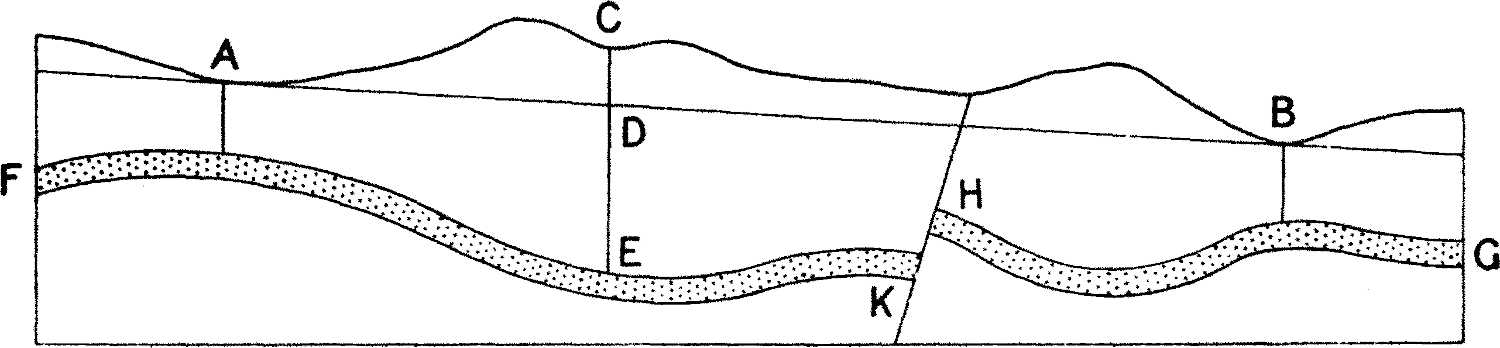
In the diagram, FEKHG represents a water-conveying stratum, folded throughout its course and faulted at HK, but having a general downward slope from F to G. A and B represent points at which the water just rises to the ground-level, either through natural fissures or in artificial borings. The straight line drawn through A and B represents very approximately the static level at any point between A and B, that is, the level to which the water would rise in bores carried down to the water-bearing bed. A boring at C, for instance, would have to go down to E to tap the water, but once the bed was tapped the water would rise in the bore as far as D. At the fault HK, the pressure of the water at K will cause it to rise through the crushed rock at the fault-plane and re-enter the porous stratum at H. If there is a considerable outflow at B, and the fault-plane is a very narrow fissure, we may expect some drop in the line AB over the fault, by reason of the extra frictional absorption of head at this place. But unless the thickness and degree of permeability of the fault-rock are markedly different from those of the sandstone bed itself, the drop of pressure will not greatly disturb the general slope AB. In any case it is apparent that the level of the static water-surface at any place between A and B is capable of being estimated with a far closer degree of approximation than is the level of the water-sheet itself. We may therefore justifiably assume a uniform gradient for the static level between points at which that level is known, disregarding folds in the strata; and though we cannot entirely allow in detail for unknown faults and variations in permeability, it must be borne in mind that the total effect of all the unknown factors between any two known points is already automatically allowed for in our data. It is only the variations from uniformity, due to the unknown distribution of the faults and of the departures from the average permeability, which can affect us; and these variations and departures are probably but small in most of the great unexplored areas of the south-west of Egypt, where the geological structure, from all we know of it, appears generally to be remarkably uniform.
The first requisite for the construction of a map showing the contours of the static water-surface was, of course, a sufficiency of well-determined positions of points where the static water-level of the artesian supply was fairly exactly known. Such points are the springs and wells of the various oases, the surfaces of lakes occupying depressions and presumably fed by underground supplies, and any places on the Nile where the river taps artesian beds.
In regard to the wells and springs, it was obvious that only those known to derive their supplies from artesian sources could be utilized as giving points on the static water-surface. This consideration cut out from the discussion the springs of Owenat and Arkenu, which are known to be fed by local rainfall, and also the small water-sources of Kurkur, Dungul, Nakheil, and Ain Amur, which occur in situations where percolation from occasional local rainfall seems to be the only possible source of supply. And for reasons which will appear presently, none of the wells and springs situated to the north of the Siwa-Qattara-Faiyum chain of depressions could be considered as entering into the problem. With these exceptions, every water-source situated within the area of the Libyan Desert covered by the map, and whose level was known, was utilized; but in the greater oases and in the Wadi Natrun the wells and springs are so numerous and so close together that in these localities it was necessary to select one or two wells as representatives of a group. I had no hesitation in including the wells of Siwa and the Wadi Natrun, because the temperature of some of the wells and springs of Siwa, and the quantity of the output of water at both places, seem to me to afford conclusive evidence of the artesian character of their supply.[18] The wells of the little oasis of Lageita, to the east of the Nile near Qena, were included, for although they are not in the Libyan Desert, they most probably derive their supplies from the same underground flow which feeds the western oases. I have included only one well in which the water does not rise nearly to the ground-level. That well is one which was bored by the British Army during the Great War, at a place called B6, some 40 kilometres to the east of Baharia Oasis. The level of the ground at this point is 112 metres above sea-level, and as the water was stationary in the bore at 78 metres below the ground, the static level here is 34 metres above sea.[19] The well is said to have yielded some 800 gallons per hour without the water-level in the bore being sensibly changed.
The level of the well at Sarra has recently been determined by Prince Kemal el Din; but I have not included it in my data, because he informs me that the water-level fluctuates by 20 metres or more in different years, while the level of the artesian water of the Egyptian oases and Merga is very nearly constant. The inference I draw from the great fluctuations in the water-level at the Sarra well is that it is dependent on percolation from a more or less local rainfall rather than on the same flow which feeds the Egyptian oases.