Front matter
Reading edition
FRAGMENTS OF EARTH LORE
PLATE I
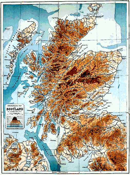
The Edinberg Geographical Institute J. G. Bartholemew, F.R.G.S.
Click on image to view larger size image.
FRAGMENTS
OF
EARTH LORE
SKETCHES & ADDRESSES
Geological and Geographical
BY
JAMES GEIKIE, D.C.L., LL.D., F.R.S., &c.
MURCHISON-PROFESSOR OF GEOLOGY AND MINERALOGY IN THE UNIVERSITY OF EDINBURGH FORMERLY OF H.M. GEOLOGICAL SURVEY OF SCOTLAND
WITH MAPS AND ILLUSTRATIONS
JOHN BARTHOLOMEW & CO. LONDON: SIMPKIN, MARSHALL, HAMILTON, KENT & Co., Ltd. 1893

PREFACE.
The articles in this volume deal chiefly with the history of Glacial times and the origin of surface-features. As they were not written with any view to their subsequent appearance in a collected form, each is so far independent and complete in itself. Under these circumstances some repetition was unavoidable, if the articles were not to be recast, and I did not think it advisable to make such radical alteration. With the exception of verbal changes and some excisions, therefore, the papers remain substantially in their original state. Here and there a footnote has been added to indicate where the views expressed in the text have since been modified; but I have not been careful to insert such notes throughout. Geologists, like other folk, live and learn, and the reader will probably discover that the opinions set forth in some of the later articles are occasionally in advance of those maintained in the writer’s earlier days.
I have to thank the Publishers of Good Words for allowing me to republish the articles on the Cheviot Hills and the Outer Hebrides. My acknowledgments are also due to Mr. Bartholomew for the excellent maps with which the volume is so well illustrated.
Edinburgh, April 5th, 1893.
LIST OF MAPS.
Plate I. PHYSICAL FEATURES OF SCOTLAND Frontispiece
” II. STRUCTURE OF MOUNTAINS 60
” III. PAST AND PRESENT GLACIATION OF THE WORLD 193
” IV. ICE AGE IN NORTHERN EUROPE 324
” V. THE GEOGRAPHICAL EVOLUTION OF CONTINENTS 348
” VI. BATHYOROGRAPHICAL MAP, ILLUSTRATING DEVELOPMENT OF COAST-LINES 428
CONTENTS.
CHAP. PAGE
I. GEOGRAPHY AND GEOLOGY 1
II. THE PHYSICAL FEATURES OF SCOTLAND 14
III. MOUNTAINS: THEIR ORIGIN, GROWTH, AND DECAY 36
IV. THE CHEVIOT HILLS 62
V. THE LONG ISLAND, OR OUTER HEBRIDES 125
VI. THE ICE AGE IN EUROPE AND NORTH AMERICA 160
VII. THE INTERCROSSING OF ERRATICS IN GLACIAL DEPOSITS 194
VIII. RECENT RESEARCHES IN THE GLACIAL GEOLOGY OF THE CONTINENT 220
IX. THE GLACIAL PERIOD AND THE EARTH-MOVEMENT HYPOTHESIS 248
X. THE GLACIAL SUCCESSION IN EUROPE 288
XI. THE GEOGRAPHICAL EVOLUTION OF EUROPE 326
XII. THE EVOLUTION OF CLIMATE 349
XIII. THE SCIENTIFIC RESULTS OF DR. NANSSEN’S EXPEDITION 382
XIV. THE GEOGRAPHICAL DEVELOPMENT OF COAST-LINES 393
I.
Geography and Geology.[A]
The teaching of Geography naturally occupies a prominent place in every school curriculum. It is rightly considered essential that we should from an early age begin to know something of our own and other countries. I am not sure, however, that Geography is always taught in the most interesting and effective manner. Indeed, according to some geographers, who are well qualified to express an opinion, the manner in which their subject is presented in many of our schools leaves much to be desired. But a decided advance has been made in recent years, and with the multiplication of excellent text-books, maps, and other appliances, I have no doubt that this improvement will continue. When I attended school the text-books used by my teachers were about as repellent as they could be. Our most important lesson was to commit to memory a multitude of place-names, and the maps which were supposed to illustrate the text-books were, if possible, less interesting and instructive. Nowadays, however, teachers have a number of more or less excellent manuals at their service, and the educational maps issued by our cartographers show in many cases a very great advance on the bald and misleading caricatures which did duty in my young days as pictures of the earth’s surface.
During the progress of some war we often remark that the task of following the military operations compels us to brush up our Geography. I am uncharitable enough to suspect that it would frequently be truer to say that, before these campaigns commenced, we had no such knowledge to brush up. The countries involved in the commotion were probably mere names to many of us. We had no immediate interest in them or their inhabitants, and had we been asked, before the outbreak of hostilities, to indicate the precise positions of the places upon a map, some of us perhaps might have been sorely puzzled to do so. Nor is such ignorance always discreditable. One cannot know everything; the land-surface of the globe contains upwards of 50 millions of square miles, and one may surely be excused for not having a detailed knowledge of this vast area. I have referred to the subject simply because I think it gives us a hint as to how the teaching of Political Geography might be made most instructive and interesting. Historical narrative might often be interwoven with the subject in such a way as to fix geographical features indelibly on the memory. Striking and picturesque incidents, eventful wars, the rise and progress of particular trades, the routes followed by commerce, the immigration and emigration of races, the gradual development of the existing political divisions of the Old World, the story of Columbus and the early voyagers, the geographical discoveries of later times—all these, and such as these, might be introduced into our lessons in Political Geography. The wanderings of a Mungo Park, a Bruce, a Livingstone, a Stanley, traced on a good map, could not fail to arrest the attention of the youthful student of African geography. In like manner, the campaigns of the great Napoleon might be made to do good service in illustrating the geographical features of large portions of our own continent. Then, as regards Britain, what a world of poetry and romantic story clings to every portion of its surface—why, the very place-names themselves might suggest to any intelligent teacher themes and incidents, the deft treatment of which would make the acquisition of Geography a delightful task to the dullest boy or girl.
The intimate relation that obtains between Political Geography and History has indeed long been recognised, and is in fact self-evident. And we are all well aware that in our school manuals of Geography it has been usual for very many years to note the scenes of remarkable events. Such notes, however, are of necessity extremely brief; and it need hardly be said that to fully incorporate history in a text-book of general Geography would be quite impracticable. It might be done to a certain extent for our own and a few of the more important countries; but similar detail need not be attempted in regard to regions which are of less consequence from the political point of view. Indeed, I should be inclined to leave the proper application of historical knowledge in the teaching of Geography very much to the teacher himself, who would naturally select such themes and incidents as seemed best adapted to attract the attention of his pupils. Be that, however, as it may, it is enough for my present purpose if I insist upon the fact that the proper study of Political Geography involves the acquisition of some historical knowledge. One can hardly conceive the possibility of an intelligent student taking pains to become acquainted with the political geography of a country without at the same time endeavouring to learn something of its history—otherwise, his geographical attainments would hardly surpass those of a commercial traveller, whose geographical studies have been confined to the maps and tables of his Bradshaw.
But if it be impossible to ignore History in the teaching of Political Geography, it is just as impossible to exclude from our attention great physical features and characteristics. Surface-configuration, climate, and natural products all claim our attention. It is obvious, in fact, that the proper study of Political Geography must give us at least a general notion of the configuration, the river-systems, and climatic conditions of many different lands. For has not the political development of races depended most largely on the physical conditions and natural resources of the countries occupied by them? So far, then, as these have sensibly influenced the progress of peoples, they come naturally under the consideration of Political Geography. Thus, if Political Geography be closely connected and interwoven, as it were, with History, not less intimate are its relations to Physical Geography. It does not embrace all Physical Geography, but it introduces us to many facts and phenomena, the causes and mutual relations of which we cannot understand without first mastering the teachings of Physical Geography. In the study of this latter science we come more closely into contact with Nature; we cease to think of the surface of the earth as parcelled out into so many lots by its human occupants—we no longer contemplate that surface from the limited point of view of the political geographer—we are now not merely members of one particular community, but have become true citizens of the world. To us north and south, east and west are of equal interest and importance. Our desire now is to understand, if haply we may, the complex system of which we ourselves form a part. The distribution of land and water—the configuration of continental areas and oceanic basins—the circulation of oceanic and terrestrial waters—earth-movements and volcanoes—ice-formations—the atmosphere—climatology—the geographical distribution of plants and animals—in a word, the world as one organic whole now forms the subject of our contemplation. Such being the scope of Physical Geography, it is satisfactory to know that its importance as a subject of study in our schools has been fully recognised. This being admitted, I shall now proceed to show that Physical Geography, although, like Political Geography, it is a separate and distinct subject, yet, just as the study of the latter involves some knowledge of History, so the prosecution of Physical Geography compels us to make a certain acquaintance with Geology. We cannot, in fact, learn much about the atmosphere, about rain and rivers, glaciers and icebergs, earthquakes and volcanoes, and the causes of climate, without at the same time becoming more or less familiar with the groundwork on which geological investigations are based. And just as a knowledge of history enables us better to understand the facts of Political Geography, so some acquaintance with the results of geological inquiry are necessary before we can hope to comprehend many of the phenomena of which Physical Geography treats. Let me try to make this plain. The physical geographer, we shall suppose, is considering the subject of terrestrial waters. He tells us what is meant by the drainage-system of a country, points out how the various minor water-courses or brooks and streams unite to form a river, describes for us the shape of the valley through which a typical river makes its way—how the valley-slope diminishes from the mountains onwards to the sea-coast—how, at first, in its upper or mountain-track, the flow of the river is torrential—how, as the slope of the valley decreases, the river begins to wind about more freely, until it reaches the head of its plain-track or delta, when, no longer receiving affluents, it begins to divide, and enters the sea at last by many mouths. He tells us further what proportion of the rainfall of the country passes seawards in our river, and he can measure for us the quantity of water which is actually discharged. All this is purely Physical Geography; but when we come to ask why some rivers flow in deep ca¤ons, like those of the Colorado—why valleys should widen out in one part and contract, as it were, elsewhere—why the courses of some rivers are interrupted by waterfalls and rapids, and many other similar questions, the physical geographer must know something of Geology before he can give an answer. He can describe the actual existing conditions; without the aid of Geology, he can tell us nothing of their origin and cause. So the political geographer can map out for us the present limits of the various countries of Europe, but History must be invoked if we would know how those boundaries came to be determined. The moment, therefore, the physical geographer begins to inquire into the origin of any particular physical feature, he enters upon the domains of the geologist. And as he cannot possibly avoid doing so, it is quite common now to find a good deal of the subject-matter of Geology treated of in text-books of Physical Geography. I state this merely to show how very closely the two sciences are interlocked. Take, for example, the configuration of river valleys just referred to. The physical geographer recognises the fact that a river performs work; by means of the sediment which it carries in suspension and rolls along its course, it erodes its bed in many places, and undermines its banks, and thus its channel is deepened and widened. He can measure the amount of sediment which it carries down to the sea, and the quantity of saline matters which its waters hold in solution: and knowing that all these substances have been abstracted from the land, he is able to estimate approximately the amount of material which is annually transferred from the surface of the drainage-area involved. He discovers this to be so relatively enormous that he has no difficulty in believing that the valleys in which rivers flow might have been hollowed out by the rivers themselves. But, without trespassing further into the geologist’s domains, he cannot go beyond this: and you will at once perceive that something more is required to prove that any particular valley owes its origin to the erosive action of running water. Suppose someone were to suggest to him that his river-valley might be a minor wrinkle in the earth’s crust caused by earth-movements, or that it might indicate the line of a fissure or dislocation, due to some comparatively recent convulsion—how could his computation of the amount of material at present carried seawards by the river prove such suggestions to be erroneous? And what light could it throw upon the origin of the varied configuration of the river-valley—how would it explain the presence or absence of cascades and rapids, of narrow gorges and open expanses? None of these phenomena can be interpreted and accounted for without the aid of the geologist: without some knowledge of rocks and rock-structures, the origin of the earth’s surface-features is quite inexplicable. To give an adequate explanation of all the surface-features of a country in detail would of course require a profound study of Geology; but a general acquaintance only with its elementary facts is quite sufficient to enable us to form a reasonable and intelligent view of the cause and origin of the main features of the land as a whole. Thus a few lessons in elementary Geology would make clear to any child how rivers have excavated valleys, why cataracts and gorges occur here, and open valleys with gently-flowing waters elsewhere.
Let me select yet another example to show how dependent Physical Geography is upon Geology. The physical geographer, in describing the features of the land, tells us how the great continental areas are traversed in various directions by what he calls mountain-chains. Thus, in speaking of America, he tells us that it may be taken as a type of the continental structure—namely a vast expanse of land, low or basin-like in the interior, and flanked along the maritime regions by elevated mountain borders—the highest border facing the deepest ocean. He points out further that the great continental areas are crossed from west to east by well-marked depressions, to a large extent occupied by water. Thus Europe is separated from Africa by the Mediterranean, a depression which is continued eastward through the Black Sea into the Aralo-Caspian area. South America is all but cut away from North America, while Australia is separated from Asia by the East India Seas. We find, in fact, all over the world that well-marked natural features are constantly being repeated. Not only do the great land-masses of the globe bear certain resemblances to each other, but even in their detailed structure similar parallelisms recur. The physical geographer notes all these remarkable phenomena, but he can give us no clue to their meaning. He may describe with admirable skill the characteristic features of plains and plateaux, of volcanic mountains and mountain-chains, but he cannot tell us why plains should occur here and mountains there; nor can he explain why some mountains, such as those of Scotland or Norway, differ so much in configuration from the Alps and the Pyrenees. The answer to all these questions can only be given by Geology. It is from this science we learn how continental areas and oceanic basins have been evolved. The patient study of the rocks has revealed the origin of the present configuration of the land. There is not a hill or valley, not a plateau or mountain-region, which does not reveal its own history. The geologist can tell you why continents are bordered by coast-ranges, and why their interiors are generally comparatively low and basin-shaped. The oceanic basins and continental areas, we learn, are primeval wrinkles in the earth’s crust, caused by its irregular subsidence upon the gradually cooling and contracting nucleus. The continents are immense plateau-like areas rising more or less abruptly above those stupendous depressions of the earth’s crust which are occupied by the ocean. While those depressions are in progress the maritime borders of the land-areas are subjected to enormous squeezing and crushing, and coast-ranges are the result—the elevation of those ranges necessarily holding some relation to the depth of the contiguous ocean. For, the deeper the ocean the greater has been the depression under the sea, and, consequently, the more intense the upheaval along the continental borders. It is for the same reason that destructive earthquakes are most likely to occur in the vicinity of coast-ranges which are of comparatively recent geological age. These, and indeed all, mountains of elevation are lines of weakness along which earth-movements may continue from time to time to take place. But all mountains are not mountains of elevation; many elevated regions owe their mountainous character simply to the erosive action of sub-aërial agents, such as rain, frost, ice, and running water, the forms assumed by the mountains being due to their petrological character and geological structure. There are, for example, no true mountains of elevation in Scotland; hence to write of the chain of the Grampians or the range of the Lowthers is incorrect and actually misleading. Without the aid of Geology the geographer cannot, in fact, discriminate between mountains of elevation and mountains of denudation; hence geographical terms so constantly in use as mountain-range and mountain-chain are very often applied by writers, ignorant of geological structure, to elevated regions which have no claim to be described either as chains or ranges. Some knowledge of Geology, therefore, is essential to us if we would have correct views of many of the grandest features of the globe. But it will be said that, after all, the physical geographer deals with the earth as we now find it; he does not need to trouble himself with the origin of the phenomena he describes. Well, as I have just shown, he cannot, even if he would, escape trenching on Geology; and if he could, his subject would be shorn of much of its interest. He recognises that the world he studies has in it the elements of change—the forces of Nature are everywhere modifying the earth’s surface—considerable changes are sometimes brought about even in one’s lifetime, while within the course of historical ages still greater mutations have taken place—he becomes conscious, in short, that the existing state of things is but the latest phase of an interminable series of changes stretching back into the illimitable past, and destined to be prolonged into the indefinite future. Thus he gladly welcomes the labours of the geologist, whose researches into the past have thrown such a flood of light upon the present. In fact, he can no more divorce his attention from the results of geological inquiry than the political geographer can shut his eyes to the facts of History.
Let me, in conclusion, give one further illustration of the close inter-dependence of the two sciences of which I am speaking. One of the subjects treated of by Physical Geography is the present geographical distribution of plants and animals. The land-surface of the globe has been mapped out into so many biological regions, each of which is characterised by its special fauna and flora. The greatest changes in the flora and fauna of a continent are met with as we pass from south to north, or vice versa. Proceeding in the direction of the latitude, the changes encountered are much less striking. Now, these facts are readily explained by the physical geographer, who points out that the distribution is due chiefly to climatic conditions—a conclusion which is obvious enough. But when we go into details we find that mere latitude will not account for all the phenomena. Take, for example, the case of the Scandinavian flora of our own Continent. It is true that this flora is largely confined to northern latitudes; but isolated colonies occur in our own mountains and in the mountains of middle and southern Europe. How are these to be accounted for? The physical geographer says that the plants grow there simply because they obtain at high levels in low latitudes the favourable climatic conditions underneath which they flourish at low levels in high latitudes. He therefore concludes that the distribution of life-forms is due to varying climatic and physical conditions. But if we ask him how those curious colonies of foreigners come to be planted on our mountains, he cannot tell. To get our answer we must come to the geologist; and he will explain that they are, as it were, living fossils—monuments of former great physical and climatic changes. He will prove to us that the climate of Europe was at a recent geological period so cold that the Scandinavian flora spread south into middle Europe, where it occupied the low grounds. When the climate became milder, then the northern invaders gradually retired—the main body migrating back to the north—while some stragglers, retreating before the stronger Germanic flora, took shelter in the mountains, whither the latter could not or would not follow, and so there our Scandinavians remain, the silent witnesses of a stupendous climatic revolution. Now, all the world over, plants and animals have similar wonderful tales to tell of former geographical changes. The flora and fauna of our country, for example, prove that the British Islands formed part of the Continent at a very recent geological period; and so, from similar evidence, we know that not long ago Europe was joined on to Africa. On the other hand, the facts connected with the present distribution of life demonstrate that some areas, such as Australia, have been separated from the nearest continental land for vastly prolonged periods of time.
It would be a very easy matter to adduce many further illustrations to show how close is the connection between the studies of the physical geographer and the geologist. I do not indeed exaggerate when I say that no one can hope to become a geologist who is not well versed in Physical Geography; nor, on the other hand, can the physical geographer possibly dispense with the aid of Geology. The two subjects are as closely related and interwoven, the one with the other, as History is with Political Geography. I do not see therefore how educationists who have admitted the great importance of Physical Geography as a branch of general education, can logically exclude Geology as a subject of instruction in schools. Already, indeed, it has been introduced by many teachers, and I am confident that ere long it will be as generally taught as Physical Geography. I would not, however, present the subject to young people as a lesson to be learned from books. A good teacher should be able to dispense with these helps, or rather hindrances—for such they really are to a young beginner. His pupils ought to have previously studied the subject of Physical Geography, and if they have been well taught they ought to have already acquired no mean store of geological knowledge. They ought, in fact, to have learned a good deal about the great forces which are continually modifying the surface of the globe, and what they have now to do is to study more particularly the results which have followed from the constant operation of those forces. We shall suppose, for example, that the teacher has described how rivers erode their channels, and waves tend to cut back a coast-line, and how the products of erosion, consisting of gravel, sand, and mud, are distributed along river-valleys and accumulated in lakes and seas. He now exhibits to his class good-sized fragments of conglomerate, sandstone, and shale, and points out how each of these rocks is of essentially the same character, and must therefore have had the same origin, as modern sedimentary accumulations. His pupils should be encouraged to examine the rocks of their own neighbourhood, whether exhibited in natural sections or artificial exposures, and to compare these with the products of modern geological action. One hour’s instruction in the field is, in fact, worth twenty hours of reading or listening to lectures. Knowledge at first hand is what is wanted. There are many excellent popular or elementary treatises dealing with Historical Geology, and these have their uses, and may be read with profit as well as pleasure. But the mere reading of such books, it is needless to say, will never make us geologists. They help no doubt to store the mind with interesting and entertaining knowledge, but they do not cultivate the faculties of observation and reasoning. And unless geology is so taught as to accomplish this result, I do not see why it should enter into any school curriculum. Further, I would remark that, however interesting a geological treatise may be, it cannot possibly stimulate the imagination as the practical study of the science is bound to do. One may put into the hands of a youth a clear and well-written description of some particular fossiliferous limestone, and he may by dint of slavish toil be able to repeat verbatim all that he has read. That is how a good deal of book-knowledge of science is acquired. Only think, however, of the drudgery it involves—the absolute waste of time and energy. But let us illustrate our lesson by means of a lump of the limestone itself; let us show him the character of the rock and the nature of its fossil contents, and his difficulties disappear. Better still—let us take him, if we can, into a limestone quarry, and he will be a dull boy indeed if he fails fully to understand what limestone is, or to realise the fact that the rock he is looking at accumulated slowly, like existing oceanic formations, at the bottom of a sea that teemed with animal life. It is unnecessary, however, that I should illustrate this subject further. I would only repeat that the beginner should be taught from the very first to use his own eyes, and to draw logical conclusions from the facts which he observes. Trained after this manner, he would acquire, not only a precise and definite knowledge of what geological data really are, but he would learn also how to interpret those data. He would become familiar, in fact, with the guiding principles of geological inquiry.
How much or how little of Historical Geology should be given in schools will depend upon circumstances. Great care, however, should be taken to avoid wearying the youthful student with strings of mere names. What good is gained by learning to repeat the names of fifty or a hundred fossils, if you cannot recognise any one of these when it is put into your hand? With young beginners I should not attempt anything of that kind. If the neighbourhood chanced to be rich in fossils, I should take my pupils out on Saturday to the sections where they were found, and let them ply their hammers and collect specimens for themselves. I should describe no fossils which they had not seen and handled. Of the more remarkable forms of extinct animals and plants, which are often represented by only fragmentary remains, I should exhibit drawings showing the creatures as they have been restored by the labours of comparative anatomists. Such restorations and ideal views of geological scenes like those given by Heer, Dana, Saporta, and others, convey far more vivid impressions of the life of a geological period than the most elaborate description. In fine, the story of our earth should be told much in the same manner as Scott wrote the history of Scotland for his grandson. There is no more reason for requiring the juvenile student to drudge through minute geological data before introducing him to the grand results of geological investigation, than there is for compelling him to study the manuscripts in our Record Offices before allowing him to read the history which has been drawn from these and similar sources of information. It is enough if at the beginning of his studies he has already learned the general nature of geological evidence and the method of its interpretation. Provided with such a stock of geological knowledge as I have indicated, our youth would leave school with some intelligent appreciation of existing physical conditions, and a not inadequate conception of world-history.
II.
The Physical Features of Scotland.[B]
Scotland, like “all Gaul,” is divided into three parts, namely, the Highlands, the Central Lowlands, and the Southern Uplands. These, as a correctly drawn map will show, are natural divisions, for they are in accordance not only with the actual configuration of the surface, but with the geological structure of the country. The boundaries of these principal districts are well defined. Thus, an approximately straight or gently undulating line taken from Stonehaven, in a south-west direction, along the northern outskirts of Strathmore to Glen Artney, and thence through the lower reaches of Loch Lomond to the Firth of Clyde at Kilcreggan, marks out with precision the southern limits of the Highland area and the northern boundary of the Central Lowlands. The line that separates the Central Lowlands from the Southern Uplands is hardly so prominently marked throughout its entire course, but it follows precisely the same north-east and south-west trend, and may be traced from Dunbar along the base of the Lammermoor and Moorfoot Hills, the Lowthers, and the hills of Galloway and Carrick, to Girvan. In each of the two mountain-tracts—the Highlands and the Southern Uplands—areas of low-lying land occur, while in the intermediate Central Lowlands isolated prominences and certain well-defined belts of hilly ground make their appearance. The statement, so frequently repeated in class-books and manuals of geography, that the mountains of Scotland consist of three (some writers say five) “ranges” is erroneous and misleading. The original author of this strange statement probably derived his ignorance of the physical features of the country from a study of those antiquated maps upon which the mountains of poor Scotland are represented as sprawling and wriggling about like so many inebriated centipedes and convulsed caterpillars. Properly speaking, there is not a true mountain-range in the country. If we take this term, which has been very loosely used, to signify a linear belt of mountains—that is, an elevated ridge notched by cols or “passes” and traversed by transverse valleys—then in place of “three” or “five” such ranges we might just as well enumerate fifty or sixty, or more, in the Highlands and Southern Uplands. Or, should any number of such dominant ridges be included under the term “mountain-range,” there seems no reason why all the mountains of the country should not be massed under one head and styled the “Scottish Range.” A mountain-range, properly so called, is a belt of high ground which has been ridged up by earth-movements. It is a fold, pucker, or wrinkle in the earth’s crust, and its general external form coincides more or less closely with the structure or arrangement of the rock-masses of which it is composed. A mountain-range of this characteristic type, however, seldom occurs singly, but is usually associated with other parallel ranges of the same kind—the whole forming together what is called a “mountain-chain,” of which the Alps may be taken as an example. That chain consists of a vast succession of various kinds of rocks, which at one time were disposed in horizontal layers or strata. But during subsequent earth-movements those horizontal beds were compressed laterally, squeezed, crumpled, contorted, and thrown, as it were, into gigantic undulations and sharper folds and plications. And, notwithstanding the enormous erosion or denudation to which the long parallel ridges or ranges have been subjected, we can yet see that the general contour of these corresponds in large measure to the plications or foldings of the strata. This is well shown in the Jura, the parallel ranges and intermediate hollows of which are formed by undulations of the folded strata—the tops of the long hills coinciding more or less closely with the arches, and the intervening hollows with the troughs. Now folded, crumpled, and contorted rock-masses are common enough in the mountainous parts of Scotland, but the configuration of the surface rarely or never coincides with the inclination of the underlying strata. The mountain-crests, so far from being formed by the tops of great folds of the strata, frequently show precisely the opposite kind of structure. In other words, the rocks, instead of being inclined away from the hill-tops like the roof of a house from its central ridge, often dip into the mountains. When they do so on opposite sides the strata of which the mountains are built up seem arranged like a pile of saucers, one within another.
There is yet another feature which brings out clearly the fact that the slopes of the surface have not been determined by the inclination of the strata. The main water-parting that separates the drainage-system of the west from that of the east of Scotland does not coincide with any axis of elevation. It is not formed by an anticlinal fold or “saddleback.” In point of fact it traverses the strata at all angles to their inclination. But this would not have been the case had the Scottish mountains consisted of a chain of true mountain-ranges. Our mountains, therefore, are merely monuments of denudation, they are the relics of elevated plateaux which have been deeply furrowed and trenched by running water and other agents of erosion. A short sketch of the leading features presented by the three divisions of the country will serve to make this plain.
The Highlands.—The southern boundary of this, the most extensive of the three divisions, has already been defined. The straightness of that boundary is due to the fact that it coincides with a great line of fracture of the earth’s crust—on the north or Highland side of which occur slates, schists, and various other hard and tough rocks, while on the south side the prevailing strata are sandstones, etc., which are not of so durable a character. The latter, in consequence of the comparative ease with which they yield to the attacks of the eroding agents—rain and rivers, frost and ice—have been worn away to a greater extent than the former, and hence the Highlands, along their southern margin, abut more or less abruptly upon the Lowlands. Looking across Strathmore from the Sidlaws or the Ochils, the mountains seem to spring suddenly from the low grounds at their base, and to extend north-east and south-west, as a great wall-like rampart. The whole area north and west of this line may be said to be mountainous, its average elevation being probably not less than 1500 feet above the sea.
A glance at the contoured or the shaded sheets of the Ordnance Survey’s map of Scotland will show better than any verbal description the manner in which our Highland mountains are grouped. It will be at once seen that to apply the term “range” to any particular area of those high grounds is simply a misuse of terms. Not only are the mountains not formed by plications and folds, but they do not even trend in linear directions. It is true that a well-trained eye can detect certain differences in the form and often in the colouring of the mountains when these are traversed from south-east to north-west. Such differences correspond to changes in the composition and structure of the rock-masses, which are disposed or arranged in a series of broad belts and narrower bands, running from south-west to north-east across the whole breadth of the Highlands. Each particular kind of rock gives rise to a special configuration, or to certain characteristic features. Thus, the mountains that occur within a belt of slate, often show a sharply cut outline, with more or less pointed peaks and somewhat serrated ridges—the Aberuchill Hills, near Comrie, are an example. In regions of gneiss and granite the mountains are usually rounded and lumpy in form. Amongst the schists, again, the outlines are generally more angular. Quartz-rock often shows peaked and jagged outlines; while each variety of rock has its own particular colour, and this in certain states of the atmosphere is very marked. The mode in which the various rocks yield to the “weather”—the forms of their cliffs and corries—these and many other features strike a geologist at once; and therefore, if we are to subdivide the Highland mountains into “ranges,” a geological classification seems the only natural arrangement that can be followed. Unfortunately, however, our geological lines, separating one belt or “range” from another, often run across the very heart of great mountain-masses. Our “ranges” are distinguished from each other simply by superficial differences of feature and structure. No long parallel hollows separate a “range” of schist-mountains from the succeeding “ranges” of quartz-rock, gneiss, or granite. And no degree of careful contouring could succeed in expressing the niceties of configuration just referred to, unless the maps were on a very large scale indeed. A geological classification or grouping of the mountains into linear belts cannot therefore be shown upon any ordinary orographical map. Such a map can present only the relative heights and disposition of the mountain-masses, and these last, in the case of the Highlands, as we have seen, cannot be called “ranges” without straining the use of that term. Any wide tract of the Highlands, when viewed from a commanding position, looks like a tumbled ocean in which the waves appear to be moving in all directions. One is also impressed with the fact that the undulations of the surface, however interrupted they may be, are broad—the mountains, however they may vary in detail according to the character of the rocks, are massive, and generally round-shouldered and often somewhat flat-topped, while there is no great disparity of height amongst the dominant points of any individual group. Let us take, for example, the knot of mountains between Loch Maree and Loch Torridon. There we have a cluster of eight pyramidal mountain-masses, the summits of which do not differ much in elevation. Thus in Liathach two points reach 3358 feet and 3486 feet; in Beinn Alligin there are also two points reaching 3021 feet and 3232 feet respectively; in Beinn Dearg we have a height of 2995 feet; in Beinn Eighe are three dominant points—3188 feet, 3217 feet, and 3309 feet. The four pyramids to the north are somewhat lower—their elevations being 2860 feet, 2801 feet, 2370 feet, and 2892 feet. The mountains of Lochaber and the Monadhliath Mountains exhibit similar relationships; and the same holds good with all the mountain-masses of the Highlands. No geologist can doubt that such relationship is the result of denudation. The mountains are monuments of erosion—they are the wreck of an old table-land—the upper surface and original inclination of which are approximately indicated by the summits of the various mountain-masses and the direction of the principal water-flows. If we in imagination fill up the valleys with the rock-material which formerly occupied their place, we shall in some measure restore the general aspect of the Highland area before its mountains began to be shaped out by Nature’s saws and chisels.
It will be observed that while streams descend from the various mountains to every point in the compass, their courses having often been determined by geological structure, etc., their waters yet tend eventually to collect and flow as large rivers in certain definite directions. These large rivers flow in the direction of the average slope of the ancient table-land, while the main water-partings that separate the more extensive drainage-areas of the country mark out, in like manner, the dominant portions of the same old land-surface. The water-parting of the North-west Highlands runs nearly north and south, keeping quite close to the western shore, so that nearly all the drainage of that region flows inland. The general inclination of the North-west Highlands is therefore easterly towards Glenmore and the Moray Firth. In the region lying east of Glenmore the average slopes of the land are indicated by the directions of the rivers Spey, Don, and Tay. These two regions—the North-west and South-east Highlands—are clearly separated by the remarkable depression of Glenmore, which extends through Loch Linnhe, Loch Lochy, and Loch Ness, and the further extension of which towards the north-east is indicated by the straight coast-line of the Moray Firth as far as Tarbat Ness. Now, this long depression marks a line of fracture and displacement of very great geological antiquity. The old plateau of the Highlands was fissured and split in two—that portion which lay to the north-west sinking along the line of fissure to a great but at present unascertained depth. Thus the waters that flowed down the slopes of the north-west portion of the broken plateau were dammed by the long wall of rock on the “up-cast,” or south-east side of the fissure, and compelled to flow off to north-east and south-west along the line of breakage. The erosion thus induced sufficed in the course of time to hollow out Glenmore and all the mountain-valleys that open upon it from the west.
The inclination of that portion of the fissured plateau which lay to the south-east is indicated, as already remarked, by the trend of the principal rivers. It was north-east in the Spey district, nearly due east in the area drained by the Don, east and south-east in that traversed by the Tay and its affluents, westerly and south-westerly in the district lying east of Loch Linnhe.[C] Thus, a line drawn from Ben Nevis through the Cairngorm and Ben Muich Dhui Mountains to Kinnaird Point passes through the highest land in the South-east Highlands, and probably indicates approximately the dominant portion of the ancient plateau. North of that line the drainage is towards the Moray Firth; east of it the rivers discharge to the North Sea; while an irregular winding line, drawn from Ben Nevis eastward through the Moor of Rannoch and southward to Ben Lomond, forms the water-parting between the North Sea and the Atlantic, and doubtless marks another dominant area of the old table-land.
That the valleys which discharge their water-flow north and east to the Moray Firth and the North Sea have been excavated by rivers and the allied agents of erosion, is sufficiently evident. All the large rivers of that wide region are typical. They show the orthodox three courses—namely, a torrential or mountain-track, a middle or valley-track, and a lower or plain-track. The same is the case with some of the rivers that flow east from the great north-and-south water-parting of the North-west Highlands, as, for example, those that enter the heads of Beauly Firth, Cromarty Firth, and Dornoch Firth. Those, however, which descend to Loch Lochy and Loch Linnhe, and the sea-lochs of Argyllshire, have no lower or plain-track. When we cross the north-and-south water-parting of the North-west Highlands, we find that many of the streams are destitute of even a middle or valley-track. The majority are mere mountain-torrents when they reach the sea. Again, on the eastern watershed of the same region, a large number of the valleys contain lakes in their upper and middle reaches, and this is the case also with not a few of the valleys that open upon the Atlantic. More frequently, however, the waters flowing west pass through no lakes, but enter the sea at the heads of long sea-lochs or fiords. This striking contrast between the east and west is not due to any difference in the origin of the valleys. The western valleys are as much the result of erosion as those of the east. The present contrast, in fact, is more apparent than real, and arises from the fact that the land area on the Atlantic side has been greatly reduced in extent by subsidence. The western fiords are merely submerged land-valleys. Formerly the Inner and Outer Hebrides were united to themselves and the mainland, the country of which they formed a part stretching west into the Atlantic, as far probably as the present 100 fathoms line. Were that drowned land to be re-elevated, each of the great sea-lochs would appear as a deep mountain-valley containing one or more lake-basins of precisely the same character as those that occur in so many valleys on the eastern watershed. Thus we must consider all the islands lying off the west coast of the Highlands, including the major portions of Arran and Bute, as forming part and parcel of the Highland division of Scotland. The presence of the sea is a mere accident; the old lands now submerged were above its level during a very recent geological period—a period well within the lifetime of the existing fauna and flora.
The old table-land of which the Highlands and Islands are the denuded and unsubmerged relics, is of vast geological antiquity. It was certainly in existence, and had even undergone very considerable erosion, before the Old Red Sandstone period, as is proved by the fact that large tracts of the Old Red Sandstone formation are found occupying hollows in its surface. Glenmore had already been excavated when the conglomerates of the Old Red Sandstone began to be laid down. Some of the low-lying maritime tracts of the Highland area in Caithness, and the borders of the Moray Firth, are covered with the sandstones of that age; and there is evidence to show that these strata formerly extended over wide regions, from which they have since been removed by erosion. The fact that the Old Red Sandstone deposits still occupy such extensive areas in the north-east of the mainland, and in Orkney, shows that the old table-land shelved away gradually to north and east, and the same conclusion may be drawn, as we have seen, from the direction followed by the main lines of the existing drainage-system. We see, in short, in the table-land of the Highlands, one of the oldest elevated regions of Europe—a region which has been again and again submerged either in whole or in part, and covered with the deposits of ancient seas and lakes, only to be re-elevated, time after time, and thus to have those deposits in large measure swept away from its surface by the long-continued action of running water and other agents of denudation.
The Central Lowlands.—The belt of low-lying ground that separates the Highlands from the Southern Uplands is, as we have seen, very well defined. In many places the Uplands rise along its southern margin as abruptly as the Highlands in the north. The southern margin coincides, in fact, for a considerable distance (from Girvan to the base of the Moorfoots) with a great fracture that runs in the same direction as the bounding fracture or fault of the Highlands. The Central Lowlands may be described, in a word, as a broad depression between two table-lands. A glance at the map will show that the principal features of the Lowlands have a north-easterly trend—the same trend, in fact, as the bounding lines of the division. To this arrangement there are some exceptions, the principal being the belt of hilly ground that extends from the neighbourhood of Paisley, south-east through the borders of Renfrewshire and Ayrshire, to the vicinity of Muirkirk. The major part of the Lowlands is under 500 feet in height, but some considerable portions exceed an elevation of 1000 feet, while here and there the hills approach a height of 2000 feet—the two highest points (2352 and 2335 feet) being attained in Ben Cleugh, one of the Ochils, and in Tinto. Probably the average elevation of the Lowland division does not exceed 350 or 400 feet. Speaking generally, the belts of hilly ground, and the more or less isolated prominences, are formed of more durable rocks than are met with in the adjacent lower-lying tracts. Thus the Sidlaws, the Ochil Hills, and the heights in Renfrewshire and Ayrshire, are composed chiefly of more or less hard and tough volcanic rocks; and when sandstones enter into the formation of a line of hills, as in the Sidlaws, they generally owe their preservation to the presence of the volcanic rocks with which they are associated. This is well illustrated by the Lomond Hills in Fifeshire, the basal and larger portion of which consists chiefly of somewhat soft sandstones, which have been protected from erosion by an overlying sheet of hard basalt-rock. All the isolated hills in the basin of the Forth are formed of knobs, bosses, and sheets of various kinds of igneous rock, which are more durable than the sandstones, shales, and other sedimentary strata by which they are surrounded. Hence it is very evident that the configuration of the Lowland tracts of Central Scotland is due to denudation. The softer and more readily disintegrated rocks have been worn away to a greater extent than the harder and less yielding masses.
Only in a few cases do the slopes of the hill-belts coincide with folds of the strata. Thus, the northern flanks of the Sidlaws and the Ochils slope towards the north-west, and this also is the general inclination of the old lavas and other rocks of which those hills are composed. The southern flanks of the same hill-belt slope in Fifeshire towards the south-east—this being also the dip or inclination of the rocks. The crest of the Ochils coincides, therefore, more or less closely, with an anticlinal arch or fold of the strata. But when we follow the axis of this arch towards the north-east into the Sidlaws, we find it broken through by the Tay valley—the axial line running down through the Carse of Gowrie to the north of Dundee. From the fact that many similar anticlinal axes occur throughout the Lowlands, which yet give rise to no corresponding features at the surface, we may conclude that the partial preservation of the anticline of the Ochils and Sidlaws is simply owing to the greater durability of the materials of which those hills consist. Had the arch been composed of sandstones and shales it would most probably have given rise to no such prominent features as are now visible.
Another hilly belt, which at first sight appears to correspond roughly to an anticlinal axis, is that broad tract of igneous rocks which separates the Kilmarnock coal-field from the coal-fields of the Clyde basin. But although the old lavas of that hilly tract slope north-east and south-west, with the same general inclination as the surface, yet examination shows that the hills do not form a true anticline. They are built up of a great variety of ancient lavas and fragmental tuffs or “ashes,” which are inclined in many different directions. In short, we have in those hills the degraded and sorely denuded fragments of an ancient volcanic bank, formed by eruptions that began upon the bottom of a shallow sea in early Carboniferous times, and subsequently became sub-aërial. And there is evidence to show that after the eruptions ceased the volcanic bank was slowly submerged, and eventually buried beneath the accumulating sediments of later Carboniferous times. The exposure of the ancient volcanic bank at the surface has been accomplished by the denudation of the stratified masses which formerly covered it, and its existence as a dominant elevation at the present day is solely due to the fact that it is built up of more resistant materials than occur in the adjacent low-lying areas. The Ochils and the Sidlaws are of greater antiquity, but have a somewhat similar history. Into this, however, it is not necessary to go.
The principal hills of the Lowlands form two interrupted belts, extending north-east and south-west, one of them, which we may call the Northern Heights, facing the Highlands, and the other, which may in like manner be termed the Southern Heights, flanking the great Uplands of the south. The former of these two belts is represented by the Garvock Hills, lying between Stonehaven and the valley of the North Esk; the Sidlaws, extending from the neighbourhood of Montrose to the valley of the Tay at Perth; the Ochil Hills, stretching along the south side of the Firth of Tay to the valley of the Forth at Bridge-of-Allan; the Lennox Hills, ranging from the neighbourhood of Stirling to Dumbarton; the Kilbarchan Hills, lying between Greenock and Ardrossan; the Cumbrae Islands and the southern half of Arran; and the same line of heights reappears in the south end of Kintyre. A well-marked hollow, trough, or undulating plain of variable width, separates these Northern Heights from the Highlands, and may be followed all the way from near Stonehaven, through Strathmore, to Crieff and Auchterarder. Between the valleys of the Earn and Teith this plain attains an abnormal height (the Braes of Doune); but from the Teith, south-west by Flanders Moss and the lower end of Loch Lomond to the Clyde at Helensburgh, it resumes its characteristic features. It will be observed also that a hollow separates the southern portion of Arran from the much loftier northern or Highland area. The tract known as the Braes of Doune, extending from Glen Artney south-east to Strath Allan, although abutting upon the Highlands, is clearly marked off from that great division by geological composition and structure, by elevation and configuration. It is simply a less deeply eroded portion of the long trough or hollow.
Passing now to the Southern Heights of the Lowlands, we find that these form a still more interrupted belt than the Northern Heights, and that they are less clearly separated by an intermediate depression from the great Uplands which they flank. They begin in the north-east with the isolated Garleton Hills, between which and the Lammermoors a narrow low-lying trough or hollow appears. A considerable width of low ground now intervenes before we reach the Pentland Hills, which are in like manner separated from the Southern Uplands by a broad low-lying tract. At their southern extremity, however, the Pentlands merge more or less gradually into a somewhat broken and interrupted group of hills which abut abruptly on the Southern Uplands, in the same manner as the Braes of Doune abut upon the slate hills of the Highland borders. In this region the greatest heights reached are in Tinto (2335 feet), and Cairntable (1844 feet), and, at the same time, the hills broaden out towards north-west, where they are continued by the belt of volcanic rocks already described as extending between the coal-fields of the Clyde and Kilmarnock. Although the Southern Heights abut so closely upon the Uplands lying to the south, there is no difficulty in drawing a firm line of demarcation between the two areas—geologically and physically they are readily distinguished. No one with any eye for form, no matter how ignorant he may be of geology, can fail to see how strongly contrasted are such hills as Tinto and Cairntable with those of the Uplands, which they face. The Southern Heights are again interrupted towards the south-east by the valleys of the Ayr and the Doon, but they reappear in the hills that extend from the Heads of Ayr to the valley of the Girvan.
Betwixt the Northern and Southern Heights spread the broad Lowland tracts that drain towards the Forth, together with the lower reaches of the Clyde valley, and the wide moors that form the water-parting between that river and the estuary of the Forth. The hills that occur within this inner region of the Central Lowlands are usually more or less isolated, and are invariably formed by outcrops of igneous rock. Their outline and general aspect vary according to the geological character of the rocks of which they are composed—some forming more or less prominent escarpments like those of the Bathgate Hills and the heights behind Burntisland and Kinghorn, others showing a soft rounded contour like the Saline Hills in the west of Fifeshire. Of the same general character as this inner Lowland region is the similar tract watered by the Irvine, the Ayr, and the Doon. This tract, as we have seen, is separated from the larger inner region lying to the east by the volcanic hills that extend from the Southern Heights north-west into Renfrewshire.
The largest rivers that traverse the Central Lowlands take their rise, as might be expected, in the mountainous table-lands to the north and south. Of these the principal are the North and South Esks, the Tay and the Isla, the Earn, and the Forth, all of which, with numerous tributaries, descend from the Highlands. And it will be observed that they have breached the line of the Northern Heights in three places—namely, in the neighbourhood of Montrose, Perth, and Stirling.
The only streams of importance coming north from the Southern Uplands are the Clyde and the Doon, both of which in like manner have broken through the Southern Heights. Now, just as the main water-flows of the Highlands indicate the average slope of the ancient land-surface before it was trenched and furrowed by the innumerable valleys that now intersect it, so the direction followed by the greater rivers that traverse the Lowlands mark out the primeval slopes of that area. One sees at a glance, then, that the present configuration of this latter division has been brought about by the erosive action of the principal rivers and their countless affluents, aided by the sub-aërial agents generally—rain, frost, ice, etc. The hills rise above the average level of the ground, not because they have been ridged up from below, but simply owing to the more durable nature of their component rocks. That the Northern and Southern Heights are breached only shows that the low grounds, now separating those heights from the adjacent Highlands and Southern Uplands, formerly stood at a higher level, and so allowed the rivers to make their way more or less directly to the sea. Thus, for example, the long trough of Strathmore has been excavated out of sandstones, the upper surface of which once reached a much greater height, and sloped outwards from the Highlands across what is now the ridge of the Sidlaw Hills. Here then, in the Central Lowlands, as in the Highlands, true mountain- or hill-ranges are absent. But if we are permitted to term any well-marked line or belt of high ground a “range,” then the Northern and Southern Heights of the Lowlands are better entitled to be so designated than any series of mountains in the Highlands.
The Southern Uplands.—The northern margin of this wide division having already been defined, we may now proceed to examine the distribution of its mountain-masses. Before doing so, however, it may be as well to point out that considerable tracts in Tweeddale, Teviotdale, and Liddesdale, together with the Cheviot Hills, do not properly belong to the Southern Uplands. In fact, the Cheviots bear the same relation to those Uplands as the Northern Heights do to the Highlands. Like them they are separated by a broad hollow from the Uplands, which they face—a hollow that reaches its greatest extent in Tweeddale, and rapidly wedges out to south-west, where the Cheviots abut abruptly on the Uplands. Even where this abrupt contact takes place, however, the different configuration of the two regions would enable any geologist to separate the one set of mountains from the other. But for geographical purposes we may conveniently disregard these geological contrasts, and include within the Southern Uplands all the area lying between the Central Lowlands and the English Border.
If there are no mountains in the Highlands so grouped and arranged as to be properly termed “ranges,” this is not less true of the Southern Uplands. Perhaps it is the appearance which those Uplands present when viewed from the Central Lowlands that first suggested the notion that they were ranges. They seem to rise like a wall out of the low grounds at their base, and extend far as eye can reach in an approximately straight line. It seems more probable, however, that our earlier cartographers merely meant, by their conventional hill-shading, to mark out definitely the water-partings. But to do so in this manner now, when the large contour maps of the Ordnance Survey may be in any one’s hands, is inexcusable. A study of those maps, or, better still, a visit to the tops of a few of the dominant points in the area under review, will effectually dispel the idea that the Southern Uplands consist of a series of ridges zigzagging across the country. Like the Highlands, the area of the Southern Uplands is simply an old table-land, furrowed into ravine and valley by the operation of the various agents of erosion.
Beginning our survey of these Uplands in the east, we encounter first the Lammermoor Hills—a broad undulating plateau—the highest elevations of which do not reach 2000 feet. West of this come the Moorfoot Hills and the high grounds lying between the Gala and the Tweed—a tract which averages a somewhat higher elevation—two points exceeding 2000 feet in height. The next group of mountains we meet is that of the Moffat Hills, in which head a number of important rivers—the Tweed, the Yarrow, the Ettrick, and the Annan. Many points in this region exceed 2000 feet, others approach 2500 feet; and some reach nearly 3000 feet, such as Broad Law (2754 feet), and Dollar Law (2680 feet). In the south-west comes the group of the Lowthers, with dominant elevations of more than 2000 feet. Then follow the mountain-masses in which the Nith, the Ken, the Cree, the Doon, and the Girvan take their rise, many of the heights exceeding 2000 feet, and a number reaching and even passing 2500 feet, the dominant point being reached in the noble mountain-mass of the Merrick (2764 feet). In the extreme south-west the Uplands terminate in a broad undulating plateau, of which the highest point is but little over 1000 feet. All the mountain-groups now referred to are massed along the northern borders of the Southern Uplands. In the south-west the general surface falls more or less gradually away towards the Solway—the 500 feet contour line being reached at fifteen miles, upon an average, from the sea-coast. In the extreme north-east the high grounds descend in like manner into the rich low grounds of the Merse. Between these low grounds and Annandale, however, the Uplands merge, as it were, into the broad elevated moory tract that extends south-east, to unite with the Cheviots—a belt of hills rising along the English Border to heights of 1964 feet (Peel Fell), and 2676 feet (the Cheviot).
The general configuration of the main mass of the Southern Uplands—that is to say, the mountain-groups extending along the northern portion of the area under review, from Loch Ryan to the coast between Dunbar and St. Abb’s Head—is somewhat tame and monotonous. The mountains are flat-topped elevations, with broad, rounded shoulders and smooth grassy slopes. Standing on the summits of the Higher hills, one seems to be in the midst of a wide, gently undulating plain, the surface of which is not broken by the appearance of any isolated peaks or eminences. Struggling across the bogs and peat-mosses that cover so many of those flat-topped mountains, the wanderer ever and anon suddenly finds himself on the brink of a deep green dale. He discovers, in short, that he is traversing an elevated undulating table-land, intersected by narrow and broad trench-like valleys that radiate outwards in all directions from the dominant bosses and swellings of the plateau. The mountains, therefore, are merely broad ridges and banks separating contiguous valleys; in a word, they are, like the mountains of the Highlands, monuments of erosion, which do not run in linear directions, but form irregular groups and masses.
The rocks that enter into the formation of this portion of the Southern Uplands have much the same character throughout. Consequently there is less variety of contour and colour than in the Highlands. The hills are not only flatter atop, but are much smoother in outline, there being a general absence of those beetling crags and precipices which are so common in the Highland regions. Now and again, however, the mountains assume a rougher aspect. This is especially the case with those of Carrick and Galloway, amongst which we encounter a wildness and grandeur which are in striking contrast to the gentle pastoral character of the Lowthers and similar tracts extending along the northern and higher parts of the Southern Uplands. Descending to details, the geologist can observe also modifications of contour even among those monotonous rounded hills. Such modifications are due to differences in the character of the component rocks, but they are rarely so striking as the modifications that arise from the same cause in the Highlands. To the trained eye, however, they are sufficiently manifest, and upon a geologically coloured map, which shows the various belts of rock that traverse the Uplands from south-west to north-east, it will be found that the mountains occurring within each of those separate belts have certain distinctive features. Such features, however, cannot be depicted upon a small orographical map. The separation of those mountains into distinct ranges, by reference to their physical aspect, is even less possible here than in the Highlands. Now and again, bands of certain rocks, which are of a more durable character than the other strata in their neighbourhood, give rise to pronounced ridges and banks, while hollows and valleys occasionally coincide more or less closely with the outcrops of the more readily eroded strata; but such features are mere minor details in the general configuration of the country. The courses of brooks and streams may have been frequently determined by the nature and arrangement of the rocks, but the general slope of the Uplands and the direction of the main lines of water-flow are at right angles to the trend of the strata, and cannot therefore have been determined in that way. The strata generally are inclined at high angles—they occur, in short, as a series of great anticlinal arches and synclinal curves, but the tops of the grand folds have been planed off, and the axes of the synclinal troughs, so far from coinciding with valleys, very often run along the tops of the highest hills. The foldings and plications do not, in a word, produce any corresponding undulations of the surface.
Mention has been made of the elevated moory tracts that serve to connect the Cheviots with the loftier Uplands lying to north-west. The configuration of these moors is tamer even than that of the regions just described, but the same general form prevails from the neighbourhood of the Moffat Hills to the head-waters of the Teviot. There, however, other varieties of rock appear, and produce corresponding changes in the aspect of the high grounds. Not a few of the hills in this district stand out prominently. They are more or less pyramidal and conical in shape, being built up of sandstones often crowned atop with a capping of some crystalline igneous rock, such as basalt. The Maiden Paps, Leap Hill, Needs Law, and others are examples. The heights draining towards Liddesdale and lower reaches of Eskdale, composed chiefly of sandstones, with here and there intercalated sheets of harder igneous rock, frequently show escarpments and terraced outlines, but have a general undulating contour; and similar features are characteristic of the sandstone mountains that form the south-west portion of the Cheviots. Towards the north-east, however, the sandstones give place to various igneous rocks, so that the hills in the north-east section of the Cheviots differ very much in aspect and configuration from those at the other extremity of the belt. They have a more varied and broken outline, closely resembling many parts of the Ochils and other portions of the Northern and Southern Heights of the Central Lowlands.
The low-lying tracts of Roxburghshire and the Merse, in like manner, present features which are common to the inner region of the Central Lowlands. Occasional ridges of hills rise above the general level of the land, as at Smailholm and Stitchell to the north of Kelso, while isolated knolls and prominences—some bald and abrupt, others smooth and rounded—help to diversify the surface. Bonchester Hill, Rubers Law, the Dunian, Penielheugh, Minto Hills, and the Eildons may be mentioned as examples. All of these are of igneous origin, some being mere caps of basalt resting upon a foundation of sandstone, while others are the stumps of isolated volcanoes.
In the maritime tracts of Galloway the low grounds repeat, on a smaller scale, the configuration of the lofty Uplands behind, for they are composed of the same kinds of rock. Their most remarkable feature is the heavy mountain-mass of Criffel, rising near the mouth of the Nith to a height of 1800 feet.
Everywhere, therefore, throughout the region of the Southern Uplands, in hilly and low-lying tracts alike, we see that the land has been modelled and contoured by the agents of erosion. We are dealing, as in the Highlands, with an old table-land, in which valleys have been excavated by running water and its helpmates. Nowhere do we encounter any linear banks, ridges, or ranges as we find described in the class-books, and represented upon many general maps of the country. In one of those manuals we read that in the southern district “the principal range of mountains is that known as the Lowther Hills, which springs off from the Cheviots, and, running in a zigzag direction to the south-west, terminates on the west coast near Loch Ryan.” This is quite true, according to many common maps, but unfortunately the “range” exists upon those maps and nowhere else. The zigzag line described is not a range of mountains, but a water-parting, which is quite another matter.
The table-land of the Southern Uplands, like that of the Highlands, is of immense antiquity. Long before the Old Red Sandstone period, it had been furrowed and trenched by running water. Of the original contour of its surface, all we can say is that it formed an undulating plateau, the general slope of which was towards south-east. This is shown by the trend of the more important rivers, such as the Nith and the Annan, the Gala and the Leader; and by the distribution of the various strata pertaining to the Old Red Sandstone and later geological periods. Thus, strata of Old Red Sandstone and Carboniferous age occupy the Merse and the lower reaches of Teviotdale, and extend up the valleys of the Whiteadder and the Leader into the heart of the Silurian Uplands. In like manner Permian sandstones are well developed in the ancient hollows of Annandale and Nithsdale. Along the northern borders of the Southern Uplands we meet with similar evidence to show that even as early as Old Red Sandstone times the old plateau, along what is now its northern margin, was penetrated by valleys that drained towards the north. The main drainage, however, then as now, was directed towards south-east.
Many geological facts conspire to show that the Silurian table-land of these Uplands has been submerged, like the Highlands, in whole or in part. This happened at various periods, and each time the land went down it received a covering of newer accumulations—patches of which still remain to testify to the former extent of the submergences. From the higher portions of the Uplands those accumulations have been almost wholly swept away, but they have not been entirely cleared out of the ancient valleys. They still mantle the borders of the Silurian area, particularly in the north-east, where they attain a great thickness in the moors of Liddesdale and the Cheviot Hills. The details of the evolution of the whole area of the Southern Uplands form an interesting study, but this pertains rather to Geology than to Physical Geography. It is enough, from our present point of view, to be assured that the main features of the country were chalked out, as it were, at a very distant geological period, and that all the infinite variety in the relief of our land has been brought about directly, not by titanic convulsions and earth-movements, but by the long-continued working of rain and rivers—of frost and snow and ice, supplemented from time to time by the action of the sea.
The physical features more particularly referred to in this paper are of course only the bolder and more prominent contours—those namely which can be expressed with sufficient accuracy upon sheets of such a size as the accompanying orographical map of Scotland (Plate I.). With larger maps considerably more detail can be added, and many characteristic and distinguishing features will appear according to the care with which such maps are drawn. In the case of the Ordnance Survey map, on the scale of 1 inch to a mile, the varying forms of the surface are so faithfully delineated as frequently to indicate to a trained observer the nature of the rocks and the geological structure of the ground. The artists who sketched the hills must indeed have had good eyes for form. So carefully has their work been done, that it is often not difficult to distinguish upon their maps hills formed of such rocks as sandstone from those that are composed of more durable kinds. The individual characteristics of mountains of schist, of granite, of quartz-rock, of slate, are often well depicted: nay, even the varieties of igneous rock which enter into the formation of the numerous hills and knolls of the Lowlands can frequently be detected by the features which the artists have so intelligently caught. Another set of features which their maps display are those due to glaciation. These are admirably brought out, even down to the smallest details. A glance at such maps as those of Teviotdale and the Merse, for example, shows at once the direction taken by the old mer de glace. The long parallel flutings of the hill-slopes, roches moutonnées, projecting knolls and hills with their “tails,” the great series of banks and ridges of stony clay which trend down the valley of the Tweed—these, and many more details of interest to specialists, are shown upon the maps. All over Scotland similar phenomena are common, and have been reproduced with marvellous skill on the shaded sheets issued by the Ordnance Survey. And yet the artists were not geologists. The present writer is glad of this opportunity of recording his obligations to those gentlemen. Their faithful delineations of physical features have given him many valuable suggestions, and have led up to certain observations which might otherwise not have been made.
III.
Mountains: Their Origin, Growth, and Decay.[D]
Mountains have long had a fascination for lovers of nature. Time was, however, when most civilised folk looked upon them with feelings akin to horror; and good people, indeed, have written books to show that they are the cursed places of the earth—the ruin and desolation of their gorges and defiles affording indubitable proof of the evils which befell the world when man lapsed from his primitive state of innocence and purity. All this has changed. It is the fashion now to offer a kind of worship to mountains; and every year their solitudes are invaded by devotees—some, according to worthy Meg Dods, “rinning up hill and down dale, knapping the chuckie-stanes to pieces wi’ hammers, like sae mony roadmakers run daft—to see, as they say, how the warld was made”—others trying to transfer some of the beauty around them to paper or canvas—yet others, and these perhaps not the least wise, content, as old Sir Thomas Browne has it, “to stare about with a gross rusticity,” and humbly thankful that they are beyond the reach of telegrams, and see nothing to remind them of the fumun et opes strepitumque Romæ. But if the sentiment with which mountains are regarded has greatly changed, so likewise have the views of scientific men as to their origin and history. Years ago no one doubted that all mountains were simply the result of titanic convulsions. The crust of the earth had been pushed up from below, tossed into great billows, shivered and shattered—the mountains corresponding to the crests of huge earth-waves, the valleys to the intervening depressions, or to gaping fractures and dislocations. This view of the origin of mountains has always appeared reasonable to those who do not know what is meant by geological structure, and in some cases it is pretty near the truth. A true mountain-chain, like that of the Alps, does indeed owe its origin to gigantic disturbances of the earth’s crust, and in such a region the larger features of the surface often correspond more or less closely with the inclination of the underlying rocks. But in many elevated tracts, composed of highly disturbed and convoluted strata, no such coincidence of surface-features and underground structure can be traced. The mountains do not correspond to great swellings of the crust—the valleys neither lie in trough-shaped strata, nor do they coincide with gaping fractures. Again, many considerable mountains are built up of rocks which have not been convoluted at all, but occur in approximately horizontal beds. Evidently, therefore, some force other than subterranean action must be called upon to explain the origin of many of the most striking surface-features of the land.
Every geologist admits—it is one of the truisms of his science—that corrugations and plications are the result of subterranean action. Nor does any one deny that when a true mountain-chain was first upheaved the greater undulations of the folded strata probably gave rise to similar undulations at the surface. Some of the larger fractures and dislocations might also have appeared at the surface and produced mural precipices. So long a time, however, has elapsed since the elevation of even the youngest mountain-chains of the globe that the sub-aërial agents of erosion—rain, frost, rivers, glaciers, etc.—have been enabled greatly to modify their primeval features. For these mountains, therefore, it is only partially true that their present slopes coincide with those of the underlying strata. Such being the case with so young a chain as the Alps, we need not be surprised to meet with modifications on a still grander scale in mountain-regions of much greater antiquity. In many such tracts the primeval configuration due to subterranean action has been entirely remodelled, so that hills now stand where deep hollows formerly existed, while valleys frequently have replaced mountains. And this newer configuration is the direct result of erosion, guided by the mineralogical composition and structural peculiarities of the rocks.
It is difficult, or even impossible, for one who is ignorant of geological structure to realise that the apparently insignificant agents of erosion have played so important a rôle in the evolution of notable earth-features. It may be well, therefore, to illustrate the matter by reference to one or two regions where the geological structure is too simple to be misunderstood. The first examples I shall give are from tracts of horizontal strata. Many readers are doubtless aware of the fact that our rock-masses consist for the most part of the more or less indurated and compacted sediments of former rivers, lakes, and seas. Frequently those ancient water-formed rocks have been very much altered, so as even sometimes to acquire a crystalline character. But it is enough for us now to remember that the crust of the globe, so far as that is accessible to observation, is built up mostly of rocks which were originally accumulated as aqueous sediments. Such being the case, it is obvious that our strata of sandstone, conglomerate, shale, limestone, etc., must at first have been spread out in approximately horizontal or gently inclined sheets or layers. We judge so from what we know of sediments which are accumulating at present. The wide flats of our river valleys, the broad plains that occupy the sites of silted-up lakes, the extensive deltas of such rivers as the Nile and the Po, the narrow and wide belts of low-lying land which within a recent period have been gained from the sea, are all made up of various kinds of sediment arranged in approximately horizontal layers. Now, over wide regions of the earth’s surface the sedimentary strata still lie horizontally, and we can often tell at what geological period they became converted into dry land. Thus, for example, we know that the elevated plateau through which the river Colorado flows is built up of a great series of nearly horizontal beds of various sedimentary deposits, which reach a thickness of many thousand feet. It is self-evident that the youngest strata must be those which occur at the surface of the plateau, and they, as we know, are of lacustrine origin and belong to the Tertiary period. Now, American geologists have shown that since that period several thousands of feet of rock-materials have been removed from the surface of that plateau—the thickness of rock so carried away amounting in some places to nearly 10,000 feet. Yet all that prodigious erosion has been effected since early Tertiary times. Indeed, it can be proved that the excavation of the Grand Ca¤on of the Colorado, probably the most remarkable river-trench in the world, has been accomplished since the close of the Tertiary period, and is therefore a work of more recent date than the last great upheaval of the Swiss Alps. The origin of the ca¤on is self-evident—it is a magnificent example of river-erosion, and the mere statement of its dimensions gives one a forcible impression of the potency of sub-aërial denudation. The river-cutting is about 300 miles long, 11 or 12 miles broad, and varies from 3000 to 6000 feet in depth.
Take another example of what denuding agents have done within a recent geological period. The Faröe Islands, some twenty in number, extend over an area measuring about 70 miles from south to north, and nearly 50 miles from west to east. These islands are composed of volcanic rocks—beds of basalt with intervening layers of fine fragmental materials, and are obviously the relics of what formerly was one continuous plateau, deeply trenched by valleys running in various directions. Subsequent depression of the land introduced the sea to these valleys, and the plateau was then converted into a group of islands, separated from each other by narrow sounds and fiords. Were the great plateau through which the Colorado flows to be partially submerged, it would reproduce on a larger scale the general phenomena presented by this lonely island-group of the North Atlantic. The flat-topped “buttes” and “mesas,” and the pyramidal mountains of the Colorado district would form islands comparable to those of the Faröes. Most of the latter attain a considerable elevation above the sea—heights of 1700, 2000, 2500, and 2850 feet being met with in several of the islands. Indeed, the average elevation of the land in this northern archipelago can hardly be less than 900 feet. The deep trench-like valleys are evidently only the upper reaches of valleys which began to be excavated when the islands formed part and parcel of one and the same plateau—the lower reaches being now occupied by fiords and sounds. It is quite certain that all these valleys are the work of erosion. One can trace the beds of basalt continuously across the bottoms, and be quite sure that the valleys are not gaping cracks or fractures. Now, as the strata are approximately horizontal, it is obvious that the hollows of the surface have nothing whatever to do with undulations produced by earth-movements. The sub-aërial erosion of the islands has resulted in the development of massive flat-topped and pyramidal mountains. These stand up as eminences simply because the rock-material which once surrounded them has been gradually broken up and carried away. Nothing can well be more impressive to the student of physical geology than the aspect presented by these relics of an ancient plateau (Plate II. Fig. 1). Standing on some commanding elevation, such as Nakkin in Suderöe, one sees rising before him great truncated pyramids—built up of horizontal beds of basalt rising tier above tier—the mountains being separated from each other by wide and profound hollows, across which the basalt-beds were once continuous. Owing to the parallel and undisturbed position of the strata, it is not hard to form an estimate of the amount of material which has been removed during the gradual excavation of the valleys. In order to do so we have simply to measure the width, depth, and length of the valleys. Thus in Suderöe, which is 19 miles long and 6 miles broad, the bottoms of the valleys are 1000 feet at least below the tops of the mountains, and some of the hollows in question are a mile in width. Now, the amount of rock worn away from this one little island by sub-aërial erosion cannot be less than that of a mass measuring 10 miles in length by 6 miles in breadth, and 800 feet in thickness. And yet the Faröe Islands are composed of rocks which had no existence when the soft clays, etc., of the London Basin were being accumulated. All the erosion referred to has taken place since the great upheaval of the Eocene strata of the Swiss Alps.
But if the evidence of erosion be so conspicuous in regions composed of horizontal strata, it is not less so in countries where the rocks are inclined at various angles to the horizon. Indeed, the very fact that inclined strata crop out at the surface is sufficient evidence of erosion. For it is obvious that these outcrops are merely the truncated ends of beds which must formerly have had a wider extension. But while the effects produced by the erosion of horizontal strata are readily perceived by the least-informed observer, it requires some knowledge of geological structure to appreciate the denudation of curved or undulating strata. And yet there is really no mystery in the matter. All we have to do is by careful observation to ascertain the mode of arrangement of the rocks—this accomplished, we have no difficulty in estimating the minimum erosion which any set of strata may have experienced. An illustration may serve to make this plain. Here, for example, is a section across a region of undulating strata (Fig. 2). Let the line A B represent the surface of the ground, and C D be any datum line—say, the sea-level. An observer at A, who should walk in the direction of B, would cross successively eight outcrops of coal; and, were he incapable of reading the geological structure of the ground, he might imagine that he had come upon eight separate coal-seams. A glance at the section, however, shows that in reality he had met with only two coals, and that the deceptive appearances, which might be misread by an incautious observer, are simply the result of denudation. In this case the tops of a series of curved or arched beds have been removed (as at E), and, by protracting the lines of the truncated beds until they meet, we can estimate the minimum amount of erosion they have sustained. Thus, if the strata between o and p be 300 feet thick, it is self-evident that a somewhat greater thickness of rock must have been removed from the top of the anticlinal arch or “saddleback” at E.
Again, let us draw a section across strata which have been fractured and dislocated, and we shall see how such fractures likewise enable us to estimate the minimum amount of erosion which certain regions have experienced. In Fig. 3 we have a series of strata containing a bed of limestone L, and a coal-seam a. The present surface of the ground is represented by the line A B. At F the strata are traversed by a fault or dislocation—the beds being thrown down for say 500 feet on the low side of the fault—so that the coal at a2 occurs now at a depth of 500 feet below its continuation at a1. At the surface of the ground there is no inequality of level—the beds overlying the coal (a2) having been removed by denudation. Were the missing rocks to be replaced, they would occupy the space contained within the dotted lines above the present surface A B. Such dislocations are of common occurrence in our coal-fields, and it is not often that they give rise to any features at the surface. We may thus traverse many level or gently-undulating tracts, and be quite unconscious of the fact that geologically we have frequently leaped up or dropped down for hundreds of feet in a single step. Nay, some Scottish streams and rivers flow across dislocations by which the strata have been shifted up or down for thousands of feet, and in some places one can have the satisfaction of sitting upon rocks which are geologically 3000 yards below or above those on which he rests his feet. In other words, thousands of feet of strata have been removed by denudation from the high sides of faults. These, as I have said, often give rise to no feature at the surface; but, occasionally, when “soft” rocks have been shifted by dislocations, and brought against “hard” rocks, the latter, by better resisting denudation than the former, cause a more or less well-marked feature at the surface, and thus betray the presence of a fault to the geologist. The phenomena presented by faults, therefore, are just as eloquent of denudation as is the truncated appearance of our strata; and only after we have carefully examined the present extension and mutual relations of our rock-masses, their varied inclination, and the size of the dislocations by which they are traversed, can we properly appreciate the degree of erosion which they have sustained. Before we are entitled to express any opinion as to the origin of the surface-features of a country, we must first know its geological structure. Until we have attained such knowledge, all our views as to the origin of mountains are of less value than the paper they are written upon.
I have spoken of the evidence of denudation which we find in our truncated and dislocated rock-masses; there is yet another line of evidence which I may very shortly point out. As every one knows, there exist in this and many other countries enormous masses of igneous rocks, which have certainly been extruded from below. Now, some of these rocks, such as granite, belong to what is called the plutonic class of rocks; they are of deep-seated origin—that is to say, they never were erupted at the surface, but cooled and consolidated at great depths in the earth’s crust. I need not go into any detail to show that this is the case—it is a conclusion based upon incontrovertible facts, and accepted by every practical geologist. When, therefore, we encounter at the actual surface of the earth great mountain-masses of granite, we know that in such regions enormous denudation has taken place. The granite appears at the surface simply because the thick rock-masses under which it solidified have been gradually removed by erosion.
The facts which I have now briefly passed in review must convince us that erosion is one of the most potent factors with which the geologist has to deal. We have seen what it has been able to effect in certain tracts composed of strata which date back to a recent geological period, such as the plateau of the Colorado and the pyramidal mountains of the Faröe Islands. If in regions built up of strata so young as the rocks of those tracts the amount of erosion be so great, we may well expect to meet with evidence of much more extensive denudation in regions which have been subjected for enormously longer periods to the action of the eroding agents.
The study of geological structure, or the architecture of the earth’s crust, has enabled us to group all mountains under these three principal heads:—
1. Mountains of Accumulation. 2. Mountains of Elevation. 3. Mountains of Circumdenudation.
1. Mountains of Accumulation.—Volcanoes may be taken as the type of this class of mountains. These are, of course, formed by the accumulation of igneous materials around the focus or foci of eruption, and their mode of origin is so generally understood, and, indeed, so obvious, that I need do no more than mention them. Of course, they are all subject to erosion, and many long-extinct volcanoes are highly denuded. Some very ancient ones, as those of our own country, have been so demolished that frequently all that remains are the now plugged-up pipes or flues through which the heated materials found a passage to the surface—all those materials, consisting of lavas and ashes, having in many cases entirely disappeared. In former times volcanic eruptions often took place along the line of an extensive fissure—the lava, instead of being extruded at one or more points, welled-up and overflowed along the whole length of the fissure, so as to flood the surrounding regions. And this happening again and again, vast plateaux of igneous rock came to be built up, such as those of the Rocky Mountains, Iceland, the Faröes, Antrim and Mull, Abyssinia and the Deccan. These are called plateaux of accumulation (see Fig. 1), and all of them are more or less highly denuded, so that in many cases the plateaux have quite a mountainous appearance. Of course, plateaux of accumulation are not always formed of igneous rocks. Any area of approximately horizontal strata of aqueous origin, rising to a height of a thousand feet or more above the sea, would come under this class of plateau—the plateau of the Colorado being a good example. Although that plateau is of recent origin, yet its surface, as we have seen, has been profoundly modified by superficial erosion; and this is true to a greater extent of plateaux which have been much longer exposed to denudation. It is obvious that even mountains and plateaux of accumulation often owe many of their present features to the action of the surface-agents of change.
2. Mountains of Elevation.—We have seen that the strata which enter most largely into the composition of the earth’s crust, so far as that is open to observation, consist of rocks which must originally have been disposed in horizontal or approximately horizontal layers. But, as every one knows, the stratified rocks are not always horizontally arranged. In Scotland they rarely are so. On the contrary, they are inclined at all angles from the horizon, and not infrequently they even stand on end. Moreover, they are often traversed by dislocations, large and small. No one doubts that these tilted and disturbed rocks are evidence of wide-spread earth-movements. And it has been long known to geologists that such movements have happened again and again in this and many other countries where similar disturbed strata occur. Some of these movements, resulting in the upheaval of enormous mountain-masses, have taken place within comparatively recent geological times. Others again date back to periods inconceivably remote. The Pyrenees, the Alps, the Caucasus, the Himalaya, which form the back-bone of Eurasia, are among the youngest mountains of the globe. The Highlands of Scotland and Scandinavia are immeasurably more ancient; they are, in point of fact, the oldest high grounds in Europe, nor are there any mountain-masses elsewhere which can be shown to be older. But while the Alps and other recent mountains of elevation still retain much of their original configuration, not a vestige of the primeval configuration of our own Highlands has been preserved; their present surface-features have no direct connection with those which must have distinguished them in late Silurian times. Our existing mountains are not, like those of the Alps, mountains of elevation.