Front matter (continued 7)
Reading edition
It is hardly necessary to pursue this particular subject further, but before leaving it, attention may be drawn for a moment to the curious conclusion that the ice-sheets were self-destructive. One is left to guess at what particular stage the sinking process began, but if the earth’s crust were as readily deformed as the extreme views I have been examining would compel one to imply, then depression must have commenced almost immediately with the accumulation of snow and ice. The several ice-sheets must soon have attained their maximum thickness, and their disappearance must have been correspondingly rapid. And yet all the evidence goes to show that a glacial epoch endured for a comparatively long time—for a time sufficient to account for a prodigious amount of rock-erosion, and for the accumulation of vast sheets of glacial débris and fluvio-glacial detritus.[BY]
If it be difficult to understand how the “earth-movement hypothesis” can account for the origin of one glacial epoch, the difficulty is not lessened when we remember that there are two or more such epochs to account for. And until the advocates of that hypothesis can furnish us with some reliable evidence, they can hardly expect us to believe in their mysterious upheavals and depressions of northern and temperate regions, and in the no less wonderfully rhythmic movements of the Isthmus of Panama. In fine, the views which I have been controverting seem to me to be untenable, inasmuch as they are founded on mere assumptions, and do not even give a reasonable and intelligible explanation of the phenomena of glaciated regions, while they practically ignore or leave unsolved the problem of interglacial conditions.
Some five-and-twenty years have now elapsed since my lamented friend and colleague, James Croll, published his well-known physical theory of the Glacial period. That theory, as you all know, has been frequently criticised by physicists and others, to whose objections Croll made a final reply in his Climate and Cosmology. In that work he has successfully defended his views, and even added considerably to the strength of his general argument. I am not aware that since then any serious objections to Croll’s theory have appeared. The only one indeed that seems to have attracted attention is that which has been urged especially by certain American geologists. Their belief is that the close of the Glacial period must have taken place at a much more recent date than Croll has inferred. And this belief of theirs is based upon various estimates which have been made as to the time required for the erosion of valleys and the accumulation of alluvial deposits since the Glacial period. Thus, according to Mr. Gilbert, the post-glacial gorge of Niagara, at the present rate of erosion, must have been excavated within 7000 years; while Mr. Winchell, from similar measurements of the post-glacial erosion of the Falls of St. Anthony, concludes that 8000 years have elapsed since the close of the Ice Age. I might cite a number of similar estimates that tend to show that since the close of the Glacial period only 7000 or 10,000 years have elapsed. What will archæologists say to this conclusion? We know that Egypt was already occupied by a civilised people nearly 6000 years ago, and their marvellously advanced civilisation at that time presupposes, according to Egyptologists, many thousands of years of development. Are we, then, prepared to admit that the close of the Ice Age coincided with the dawn of Egyptian civilisation? But all American observers are not so parsimonious with regard to post-glacial time. Thus Professor Spencer has given the age of the Falls of Niagara as 24,000 years, and he informed me recently that this does not represent half of the time since the formation of the third great series of glacial deposits of the Canadian uplands. In our own Continent similar estimates have been based on the rate of erosion of river-valleys, the rate of accumulation of alluvial deposits, of peat-bogs, of stalagmite in caves, and what not, with results that, to say the least, are rather discordant. The fact is that all such measurements and estimates, however carefully conducted and cautiously made, are in the nature of things unreliable. We are insufficiently acquainted with all the factors of the problem to be solved, and I cannot therefore agree with those who attribute much weight to conclusions based on such uncertain data. Dr. Croll’s theory may eventually be modified, but I feel sure that it will not be overturned by the inconclusive and unsatisfactory estimates to which I have referred. Moreover, opponents of that theory may be reminded that its truth does not rest on the accuracy of its author’s conclusion as to the date of the last Ice Age. That periods of high eccentricity of the earth’s orbit have occurred is beyond all doubt, but whether the formulæ employed by Croll in calculating the date of the last great cycle can be relied upon for that purpose is quite another question. At present, so far as I understand the facts, the glacial and the interglacial phenomena are explained by the astronomical theory, and by no other. It gives a simple, coherent, and consistent interpretation of the climatic vicissitudes of the Pleistocene and post-glacial periods, and in especial it is the only theory that throws any light on the very remarkable climates of interglacial times.
X.
The Glacial Succession in Europe.[BZ]
For many years geologists have recognised the occurrence of at least two boulder-clays in the British Islands and the corresponding latitudes of the Continent. It is no longer doubted that these are the products of two separate and distinct glacial epochs. This has been demonstrated by the appearance of intercalated deposits of terrestrial, freshwater, or, as the case may be, marine origin. Such interglacial accumulations have been met with again and again in Britain, and they have likewise been detected at many places on the Continent, between the border of the North Sea and the heart of Russia. Their organic contents indicate in some cases cold climatic conditions; in others, they imply a climate not less temperate or even more genial than that which now obtains in the regions where they occur. Nor are such interglacial beds confined to northern and north-western Europe. In the Alpine Lands of the central and southern regions of our Continent they are equally well developed. Impressed by the growing strength of the evidence, it is no wonder that geologists, after a season of doubt, should at last agree in the conclusion that the glacial conditions of the Pleistocene period were interrupted by at least one protracted interglacial epoch. Not a few observers go further, and maintain that the evidence indicates more than this. They hold that three or even more glacial epochs supervened in Pleistocene times. This is the conclusion I reached many years ago, and I now purpose reviewing the evidence which has accumulated since then, in order to show how far it goes to support that conclusion.
In our islands we have, as already remarked, two boulder-clays, of which the lower or older has the wider extension southwards, for it has been traced as far as the valley of the Thames. The upper boulder-clay, on the other hand, does not extend south of the midlands of England. In the north of England, and throughout Scotland and the major portion of Ireland, it is this upper boulder-clay which usually shows at the surface. The two clays, however, frequently occur together, and are exposed again and again in deep artificial and natural sections, as in pits, railway-cuttings, quarries, river-banks, and sea-cliffs. Sometimes the upper clay rests directly upon the lower; at other times they are separated by alluvial and peaty accumulations or by marine deposits. The wider distribution of the lower till, the direction of transport of its included erratics, and the trend of the underlying roches moutonnées and rock-striæ, clearly show that the earlier mer de glace covered a wider area than its successor, and was confluent on the floor of the North Sea with the Scandinavian ice-sheet. It was during the formation of the lower till, in short, that glaciation in these islands attained its maximum development.
The interglacial beds, which in many places separate the lower from the upper till, show that after the retreat of the earlier mer de glace the climate became progressively more temperate, until eventually the country was clothed with a flora essentially the same as the present. Wild oxen, the great Irish deer, and the horse, elephant, rhinoceros, and other mammals then lived in Britain. From the presence of such a flora and fauna we may reasonably infer that the climate during the climax of interglacial times was as genial as now. The occurrence of marine deposits associated with some of the interglacial peaty beds shows that eventually submergence ensued; and as the shells in some of the marine beds are boreal and arctic forms, they prove that cold climatic conditions accompanied the depression of the land. To what extent the land sank under water we cannot tell. It may have been 500 feet or not so much, for the evidence is somewhat unsatisfactory.
The upper boulder-clay of our islands is the product of another mer de glace, which in Scotland would seem to have been hardly less thick and extensive than its predecessor. Like the latter, it covered the whole country, overflowed the Outer Hebrides, and became confluent with the Scandinavian inland-ice on the bed of the North Sea. But it did not flow so far to the south as the earlier ice-sheet.
It is well known that this later mer de glace was succeeded in our mountain-regions by a series of large local glaciers, which geologists generally believe were its direct descendants. It is supposed, in short, that the inland-ice, after retreating from the low-grounds, persisted for a time in the form of local glaciers in mountain-valleys. This view I also formerly held, although there were certain appearances which seemed to indicate that, after the ice-sheet had melted away from the Lowlands and shrunk far into the mountains, a general advance of great valley-glaciers had taken place. I had observed, for example, that the upper boulder-clay is often well developed in the lower reaches of our mountain-valleys—that, in fact, it may be met with more or less abundantly up to the point at which large terminal moraines are encountered. More than this, I had noticed that upland valleys, in which no local or terminal moraines occur, are usually clothed and paved with boulder-clay throughout. Again, the aspect of valleys which have been occupied by large local glaciers is very suggestive. Above the point at which terminal moraines occur only meagre patches of till are met with on the bottoms of the valleys. The adjacent hill-slopes up to a certain line may show bare rock, sprinkled perchance with erratics and superficial morainic detritus; but above this line, if the acclivity be not too great, boulder-clay often comes on again. These appearances are most conspicuously displayed in the southern Uplands of Scotland, particularly in south Ayrshire and Galloway, and long ago they led me to suspect that the local glaciers into which our latest mer de glace was resolved, after retreating continuously towards the heads of their valleys, so as to leave the boulder-clay in a comparatively unmodified condition, had again advanced and ploughed this out, down to the point at which they dropped their terminal moraines. Subsequent observations in the Highlands and the Inner and Outer Hebrides confirmed me in my suspicion, for in all those regions we meet with phenomena of precisely the same kind. My friends and colleagues, Messrs. Peach and Horne, had independently come to a similar conclusion; and the more recent work of the Geological Survey in the north-west Highlands, as they inform me, has demonstrated that after the dissolution of the general ice-sheet underneath which the upper boulder-clay was accumulated, a strong recrudescence of glacial conditions supervened, and a general advance of great valley-glaciers took place—the glaciers in many places coalescing upon the low-grounds to form united mers de glace of considerable extent.
The development of these large glaciers, therefore, forms a distinct stage in the history of the Glacial period. They were of sufficient extent to occupy all the fiords of the northern and western Highlands, at the mouths of which they calved their icebergs, and they descended the valleys on the eastern slopes of the land into the region of the great lakes, at the lower ends of which we encounter their outermost terminal moraines. The Shetland and Orkney Islands and the Inner and Outer Hebrides at the same time nourished local glaciers, not a few of which flowed into the sea. Such, for example, was the case in Skye, Harris, South Uist, and Arran. The broad Uplands of the south were likewise clothed with snow-fields that fed numerous glaciers. These were especially conspicuous in the wilds of Galloway, but they appeared likewise in the Peeblesshire hills; and even in less elevated tracts they have left more or less well-marked traces of their former presence.
It is to this third epoch of glaciation that I would assign the final scooping out of our lake-basins and the completion of the deep depressions in the beds of our Highland fiords. All the evidence, indeed, leads to the conviction that the epoch was one of long duration.
It goes without saying that what holds good for Scotland must, within certain limits, hold good also for Ireland and England. In Wales and the Cumberland lake district, and in the mountain-regions of the sister island, we meet with evidence of similar conditions. Each of those areas has obviously experienced intense local glaciation subsequent to the disappearance of the last big ice-sheet.
Attention must now be directed to another series of facts which help us to realise the general conditions that obtained during the epoch of local glaciation. In the basin of the estuary of the Clyde, and at various other places both on the west and east coasts of Scotland, occur certain clays and sands, which overlie the upper boulder-clay, and in some places are found wrapping round the kames and osar of the last great ice-sheet. These beds are charged with the relics of a boreal and arctic fauna, and indicate a submergence of rather more than 100 feet. In the lower reaches of the rivers Clyde, Forth, and Tay the clays and sands form a well-marked terrace, and a raised sea-beach, containing similar organisms, occurs here and there on the sea-coast, as between Dundee and Arbroath, on the southern shores of the Moray Firth, and elsewhere. When the terraces are traced inland they are found to pass into high-level fluviatile gravels, which may be followed into the mountain-valleys, until eventually they shade off into fluvio-glacial detritus associated with the terminal moraines of the great local glaciers. It is obvious, in short, that the epoch of local ice-sheets and large valley-glaciers was one also of partial submergence. This is further shown by the fact that in some places the glaciers that reached the sea threw down their moraines on the 100-feet beach. It must have been an epoch of much floating ice, as the marine deposits contain now and again many erratics, large and small, and are, moreover, frequently disturbed and contorted as if from the grounding of pack-ice.
The phenomena which I have thus briefly sketched suffice to show that the epoch of local glaciation is to be clearly distinguished from that of the latest general mer de glace. I have long suspected, indeed, that the two may have been separated by as wide an interval of time as that which divided the earlier from the later epoch of general glaciation. Again and again I have searched underneath the terminal moraines, in the faint hope of detecting interglacial accumulations. My failure to discover these, however, did not weaken my conviction, for it was only by the merest chance that interglacial beds could ever have been preserved in such places. I feel sure, however, that they must occur among the older alluvia of our Lowlands. Indeed, as I shall point out in the sequel, it is highly probable that they are already known, and that we have hitherto failed to recognise their true position in the glacial series.
Although we have no direct evidence to prove that a long interglacial epoch of mild conditions immediately preceded the advent of our local ice-sheets and large valley-glaciers, yet the indirect evidence is so strong that we seem driven to admit that such must have been the case. To show this I must briefly recapitulate what is now known as to the glacial succession on the Continent. It has been ascertained, then, that the Scandinavian ice has invaded the low-grounds of Germany on two separate occasions, which are spoken of by Continental geologists as the “first” and “second” glacial epochs. The earlier of these was the epoch of maximum glaciation, when the inland ice flowed south into Saxony, and overspread a vast area between the borders of the North Sea and the base of the Ural Mountains. This ice-sheet unquestionably coalesced with the mer de glace of the British Islands. Its bottom-moraine and the associated fluvio-glacial detritus are known in Germany as “Lower Diluvium,” and the various phenomena connected with it clearly show that the inland-ice radiated outwards from the high-grounds of Scandinavia. The terminal front of that vast mer de glace is roughly indicated by a line drawn from the south coast of Belgium round the north base of the Harz, and by Leipzig and Dresden to Krakow, thence north-east to Nijnii Novgorod, and further north to the head-waters of the Dvina and the shores of the Arctic Sea near the Tcheskaia Gulf.
The lower diluvium is covered in certain places by interglacial deposits and an overlying upper diluvium—a succession clearly indicative of climatic changes. In the interglacial beds occur remains of Elephas antiquus and other Pleistocene mammals, and a flora which denotes a genial temperate climate. One of the latest discoveries of interglacial remains is that of two peat-beds lying between the lower and upper diluvium near Grünenthal in Holstein.[CA] Among the abundant plant-relics are pines and firs (no longer indigenous to Schleswig-Holstein), aspen, willow, white birch, hazel, hornbeam, oak, and juniper. Associated with these are Ilex and Trapa natans, the presence of which, as Dr. Weber remarks, betokens a climate like that of western middle Germany. Amongst the plants is a water-lily, which occurs also in the interglacial beds of Switzerland, but is not now found in Europe. The evidence furnished by this and other interglacial deposits in north Germany shows that, after the ice-sheet of the lower diluvium had melted away, the climate became as temperate as that now experienced in Europe. Another recent find of the same kind[CB] is the “diluvial” peat, etc., of Klinge, in Brandenburg, described by Professor Nehring. These beds have yielded remains of elk (Cervus alces), rhinoceros (species not determined), a small fox (?), and Megaceros. This latter is not the typical great Irish deer, but a variety (C. megaceros, var. Ruffii, Nehring). The plant-remains include pine, fir (Picea excelsa), hornbeam, warty birch (Betula verrucosa), various willows (Salix repens, S. aurita, S. caprea [?], S. cinerea), hazel, poplar (?), common holly, etc. It is worthy of note that here also the interglacial water-lily (Cratopleura) of Schleswig-Holstein and Switzerland makes its appearance. Dr. Weber writes me that the facies of this flora implies a well-marked temperate insular climate (Seeklima). The occurrence of holly in the heart of the Continent, where it no longer grows wild, is particularly noteworthy. The evidence furnished by such a flora leads one to conclude that at the climax of the genial interglacial epoch, the Scandinavian snow-fields and glaciers were not more extensive than they are at present.
The presence of the upper diluvium, however, proves that such genial conditions eventually passed away, and that an ice-sheet again invaded north Germany. But this later invasion was not on the same scale as that of the preceding one. The geographical distribution of the upper diluvium and the position of large terminal moraines put this quite beyond doubt. The boulder-clay in question spreads over the Baltic provinces of Germany, extending south as far as Berlin,[CC] and west into Schleswig-Holstein and Denmark. At the climax of this later cold epoch glaciers occupied all the fiords of Norway, but did not advance beyond the general coast-line. Norway at that time must have greatly resembled Greenland—the inland-ice covering the interior of the country, and sending seawards large glaciers that calved their icebergs at the mouths of the great fiords. In the extreme south, however, the glaciers did not quite reach the sea, but piled up large terminal moraines on the coast-lands, which may be followed thence into Sweden in an easterly direction by the lower end of Lake Wener and through Lake Wetter. A similar belt of moraines marks out the southern termination of the ice-sheet in Finland. Between Sweden and Finland lies the basin of the Baltic, which, at the epoch in question was filled with ice, forming a great Baltic glacier. This glacier overflowed the Öland Islands, Gottland, and Öland, fanning out as it passed towards the south-west and west, so as to invade on the south the Baltic provinces of Germany, while in the north it traversed the southern part of Scania, and overwhelmed the Danish islands as it spread into Jutland and Schleswig-Holstein. The course of this second ice-sheet is indicated by the direction of transport of erratics, etc., and by the trend of rock-striæ and roches moutonnées, as well as by the position of its terminal and lateral moraines.
Such, then, is the glacial succession which has been established by geologists in Scandinavia, north Germany, and Finland. The occurrence of two glacial epochs, separated by a long interval of temperate conditions, has been proved. The evidence, however, does not show that there may not have been more than two glacial epochs. There are certain phenomena, indeed, connected with the glacial accumulations of the regions in question which strongly suggest that the succession of changes was more complex than is generally understood. Several years ago Dr. A. G. Nathorst adduced evidence to show that a great Baltic glacier, similar to that underneath which the upper diluvium was amassed, existed before the advent of the vast mer de glace of the so-called “first glacial epoch,”[CD] and his observations have been confirmed and extended by H. Lundbohm.[CE] The facts set forth by them prove beyond doubt that this early Baltic glacier smoothed and glaciated the rocks in southern Sweden in a direction from south-east to north-west, and accumulated a bottom-moraine whose included erratics are equally cogent evidence as to the trend of glaciation. That old moraine is overlaid by the lower diluvium—i.e., the boulder-clay, etc., of the succeeding vast mer de glace that flowed south to the foot of the Harz—the transport of the stones in the superjacent clay indicating a movement from NNE. to SSW., or nearly at right angles to the trend of the earlier Baltic glacier. It is difficult to avoid the conclusion that we have here to do with the products of two distinct ice-epochs. But hitherto no interglacial deposits have been detected between the boulder-clays in question. It might, therefore, be held that the early Baltic glacier was separated by no long interval of time from the succeeding great mer de glace, but may have been merely a stage in the development of the latter. It is at all events conceivable that before the great mer de glace attained its maximum extension, it might have existed for a time as a large Baltic glacier. I would point out, however, that if no interglacial beds had been recognised between the lower and the upper diluvium, geologists would probably have considered that the last great Baltic glacier was simply the attenuated successor of the preceding continental mer de glace. But we know this was not so; the two were actually separated by a long epoch of genial temperate conditions.
There are certain other facts that may lead us to doubt whether in the glacial phenomena of the Baltic coast-lands we have not the evidence of more than two glacial epochs. Three, and even four, boulder-clays have been observed in east and west Prussia. They are separated, the one from the other, by extensive aqueous deposits, which are sometimes fossiliferous. Moreover, the boulder-clays in question have been followed continuously over considerable areas. It is quite possible, of course, that all those boulder-clays may be the product of one epoch, laid down during more or less considerable oscillations of an ice-sheet. In this view of the case the intercalated aqueous deposits would indicate temporary retreats, while the boulder-clays would represent successive re-advances of one and the same mer de glace. On the other hand, it is equally possible, if not more probable, that the boulder-clays and intercalated beds are evidence of so many separate glacial and interglacial epochs. We cannot yet say which is the true explanation of the facts. But these being as they are, we may doubt if German glacialists are justified in so confidently maintaining that their lower and upper diluvial accumulations are the products of the “first” and “second” glacial epochs. Indeed, as I shall show presently, the upper diluvium of north Germany and Finland cannot represent the second glacial epoch of other parts of Europe.
For a long time it has been supposed that the glacial deposits of the central regions of Russia were accumulated during the advance and retreat of one and the same ice-sheet. In 1888, however, Professor Pavlow brought forward evidence to show that the province of Nijnii Novgorod had been twice invaded by a general mer de glace. During the first epoch of glaciation the ice-sheet overflowed the whole province, while only the northern half of the same region was covered by the mer de glace of the second invasion. Again, Professor Armachevsky has pointed out that in the province of Tchernigow two types of glacial deposits appear, so unlike in character and so differently distributed that they can hardly be the products of one and the same ice-sheet. But until recently no interglacial deposits had been detected, and the observations just referred to failed, therefore, to make much impression. The missing link in the material evidence has now happily been supplied by M. Krischtafowitsch.[CF] At Troïzkoje, in the neighbourhood of Moscow, occur certain lacustrine formations which have been long known to Russian geologists. These have been variously assigned to Tertiary, lower glacial, post-glacial, and pre-glacial horizons. They are now proved, however, to be of interglacial age, for they rest upon and are covered by glacial accumulations. Amongst their organic remains are oak (Quercus pedunculata), alder (Alnus glutinosa, A. incana), white birch, hazel, Norway maple (Acer platanoides), Scots fir, willow, water-lilies (Nuphar, Nymphæa), mammoth, pike, perch, Anadonta, wing-cases of beetles, etc. The character of the plants shows that the climate of central Russia was milder and more humid than it is to-day.
It is obvious that the upper and lower glacial deposits of central Russia cannot be the equivalents of the upper and lower diluvium of the Baltic coast-lands. The upper diluvium of those regions is the bottom-moraine of the so-called great Baltic glacier. At the time that glacier invaded north Germany, Finland was likewise covered with an ice-sheet, which flowed towards the south-east, but did not advance quite so far as the northern shores of Lake Ladoga. A double line of terminal moraines, traced from Hango Head on the Gulf of Finland, north-east to beyond Joensuu, puts this beyond doubt.[CG] The morainic deposits that overlie the interglacial beds of central Russia cannot, therefore, belong to the epoch of the great Baltic glacier. They are necessarily older. In short, it is obvious that the upper and lower glacial accumulations near Moscow must be on the horizon of the lower diluvium of north Germany. And if this be so, then it is clear that the latter cannot be entirely the product of one and the same mer de glace. When the several boulder-clays described by Schröder and others as occurring in the Baltic provinces of Germany are reinvestigated, they may prove to be the bottom-moraines of as many distinct and separate glacial epochs.
It may be contended that the glacial and interglacial deposits of central Russia are perhaps only local developments—that their evidence may be accounted for by the oscillations of one single mer de glace. This explanation, as already pointed out, has been applied to the boulder-clays and intercalated aqueous beds of the lower diluvium of north Germany, and the prevalent character of the associated organic remains makes it appear plausible. It is quite inapplicable, however, to the similar accumulations in central Russia. During the formation of the freshwater beds of Troïzkoje, no part of Russia could have been occupied by an ice-sheet; the climate was more genial and less “continental” than the present. Yet that mild interglacial epoch was preceded and succeeded by extremely arctic conditions. It is impossible that such excessive changes could have been confined to central Russia. Germany, and indeed all northern and north-western Europe, must have participated in the climatic revolutions.
So far, then, as the evidence has been considered, we may conclude that three glacial and two interglacial epochs at least have been established for northern Europe. If this be the case, then a similar succession ought to occur in our own islands; and a little consideration of the evidence already adduced will suffice to show that it does. It will be remembered that the lower and upper boulder-clays of the British Islands are the bottom-moraines of two separate and distinct ice-sheets, each of which in its time coalesced on the floor of the North Sea with the inland-ice of Scandinavia. It is obvious, therefore, that our upper boulder-clay cannot be the equivalent of the upper diluvium of the Baltic coast-lands, of Sweden, Denmark, and Schleswig-Holstein. De Geer and others have shown that while the great Baltic glacier was accumulating the upper diluvium of North Germany, etc., the inland-ice of Norway calved its icebergs at the mouths of the great fiords. Thus, during the so-called “second” glacial epoch of Scandinavian and German geologists, the Norwegian inland-ice did not coalesce with any British mer de glace. The true equivalent in this country of the upper diluvium is not our upper boulder-clay, but the great valley-moraines of our mountain-regions. It is our epoch of large valley-glaciers which corresponds to that of the great Baltic ice-flow. Our upper and lower boulder-clays are on the horizon of the lower diluvium of Germany and the glacial deposits of central Russia.
It will now be seen that the evidence in Britain is fully borne out by what is known of the glacial succession in the corresponding latitudes of the Continent. I had inferred that our epoch of large valley-glaciers formed a distinct stage by itself, and was probably separated from that of the preceding ice-sheet by a prolonged interval of interglacial conditions. One link in the chain of evidence, however, was wanting: I could not point to the occurrence of interglacial deposits underneath the great valley-moraines. But these, as we have seen, form a well-marked horizon on the Continent, and we cannot doubt that a similar interglacial stage obtained in these islands. We may feel confident, in fact, that genial climatic conditions supervened on the dissolution of the last great mer de glace in Britain, and that the subsequent development of extensive snow-fields and glaciers in our mountain-regions was contemporaneous with the appearance of the last great Baltic glacier.
We need not be surprised that interglacial beds should be well developed underneath the bottom-moraine of that great glacier, while they have not yet been recognised below the corresponding morainic accumulations of our Highlands and Uplands. The conditions in the low-grounds of the Baltic coast-lands favoured their preservation, for the ice in those regions formed a broad mer de glace, under the peripheral areas of which sub-glacial erosion was necessarily at a minimum and the accumulation at a maximum. In our Scottish mountain-valleys, however, the very opposite was the case. The conditions obtaining there were not at all comparable to those that characterised the low-grounds of northern Germany, etc., but were quite analogous to those of Norway, where, as in our own mountain-regions, interglacial beds are similarly wanting. It is quite possible, however, that patches of such deposits may yet be met with underneath our younger moraines, and they ought certainly to be looked for. But whether they occur or not in our mountain-valleys, it is certain that some of the older alluvia of our Lowlands must belong to this horizon. Hitherto all alluvial beds that overlie our upper boulder-clay have been classified as post-glacial; but since we have ascertained that our latest mer de glace was succeeded by genial interglacial conditions, we may be sure that records of that temperate epoch will yet be recognised in such Lowland tracts as were never reached by the glaciers of the succeeding cold epoch. Hence, I believe that some of our so-called “post-glacial” alluvia will eventually be assigned to an interglacial horizon. Amongst these may be cited the old peat and freshwater beds that rest upon the upper boulder-clay at Hailes Quarry, near Edinburgh. To the same horizon, in all probability, belong the clays, with Megaceros, etc., which occur so frequently underneath the peat-bogs of Ireland. An interesting account of these was given some years ago by Mr. Williams,[CH] who, as a collector of Megaceros remains, had the best opportunity of ascertaining the nature of the deposits in which these occur. He gives a section of Ballybetagh Bog, nine miles south-east of Dublin, which is as follows:—
1. Boulder-clay. 2. Fine tenacious clay, without stones. 3. Yellowish clay, largely composed of vegetable matter. 4. Brownish clay, with remains of Megaceros. 5. Greyish clay. 6. Peat.
The beds overlying the boulder-clay are evidently of lacustrine origin. The fine clay (No. 2), according to Mr. Williams, is simply reconstructed boulder-clay. After the disappearance of the mer de glace the land would for some time be practically destitute of any vegetable covering, and rain would thus be enabled to wash down the finer ingredients of the boulder-clay that covered the adjacent slopes, and sweep them into the lake. The clay formed in this way is described as attaining a considerable thickness near the centre of the old lake, but it thins off towards the sides. The succeeding bed (No. 3) consists so largely of vegetable débris that it can hardly be called a clay. Mr. Williams describes it as a “bed of pure vegetable remains that has been ages under pressure.” He notes that there is a total absence in this bed of any tenacious clay like that of the underlying stratum, and infers, therefore, that the rainfall during the growth of the lacustrine vegetation was not so great as when the subjacent clay was being accumulated. The remains of Megaceros occur resting on the surface of the plant-bed and at various levels in the overlying brownish clay, which attains a thickness of three to four feet. The latter is a true lacustrine sediment, containing a considerable proportion of vegetable matter, interstratified with seams of clay and fine quartz-sand. According to Mr. Williams, it was accumulated under genial or temperate climatic conditions like the present. Between this bed and the overlying greyish clay (from 30 inches to 3 feet thick) there is always in all the bog deposits examined by Mr. Williams a strongly-marked line of separation. The greyish clay consists exclusively of mineral matter, and has evidently been derived from the disintegration of the adjacent granitic hills. Mr. Williams is of opinion that this clay is of aqueo-glacial formation. This he infers from its nature and texture, and from its abundance. “Why,” he asks, “did not this mineral matter come down in like quantity all the time of the deposit of the brown clay which underlies it? Simply because, during the genial conditions which then existed, the hills were everywhere covered with vegetation; when the rain fell it soaked into the soil, and the clay being bound together by the roots of the grasses, was not washed down, just as at the present time, when there is hardly any degradation of these hills taking place.” He mentions, further, that in the grey clay he obtained the antler of a reindeer, and that in one case the antlers of a Megaceros, found embedded in the upper surface of the brown clay, immediately under the grey clay, were scored like a striated boulder, while the under side showed no markings. Mr. Williams also emphasises the fact that the antlers of Megaceros frequently occur in a broken state—those near the surface of the brown clay being most broken, while those at greater depths are much less so. He shows that this could not be the result of tumultuous river-action—the elevation of the valley precluding the possibility of its receiving a river capable of producing such effects. Moreover, the remains show no trace of having been water-worn, the edges of the teeth of the great deer being as sharp as if the animal had died but yesterday. Mr. Williams thinks that the broken state of the antlers is due to the “pressure of great masses of ice on the surface of the clay in which they were embedded, the wide expanse of the palms of the antlers exposing them to pressure and liability to breakage; and even, in many instances, when there was 12 or 14 inches in circumference of solid bone almost as hard and sound as ivory, it was snapped across.” It is remarkable that in this one small bog nearly one hundred heads of Megaceros have been dug up.
Mr. Williams’ observations show us that the Megaceros-beds are certainly older than the peat-bogs with their buried timber. When he first informed me of the result of his researches (1880), I did not believe the Megaceros-beds could be older than the latest cold phase of the Ice Age. I thought that they were later in date than our last general mer de glace, and I think so still, for they obviously rest upon its ground-moraine. But since I now recognise that our upper boulder-clay is not the product of the last glacial epoch, it seems to me highly probable that the Megaceros-beds are of interglacial age—that, in short, they occupy the horizon of the interglacial deposits of north Germany, etc. The appearances described by Mr. Williams in connection with the “grey clay” seem strongly suggestive of ice-action. Ballybetagh Bog occurs at an elevation of 800 feet above the sea, in the neighbourhood of the Three Rock Mountain (1479 feet), and during the epoch of great valley-glaciers the climatic conditions of that region must have been severe. But without having visited the locality in question I should hesitate to say that the phenomena necessarily point to local glaciation. Probably frost, lake-ice, and thick accumulations of snow and névé might suffice to account for the various facts cited by Mr. Williams.
I have called special attention to these Irish lacustrine beds, because it is highly probable that the post-glacial age of similar alluvia occurring in many other places in these islands has hitherto been assumed and not proved. Now that we know, however, that a long interglacial stage succeeded the disappearance of the last general mer de glace, we may feel sure that the older alluvia of our Lowland districts cannot belong exclusively to post-glacial times. The local ice-sheets and great glaciers of our “third” glacial epoch were confined to our mountain-regions; and in the Lowlands, therefore, which were not invaded, we ought to have the lacustrine and fluviatile accumulations of the preceding interglacial stage. A fresh interest now attaches to our older alluvia, which must be carefully re-examined in the new light thus thrown upon them.
Turning next to the Alpine Lands of central Europe, we find that geologists there have for many years recognised two glacial epochs. Hence, like their confrères in northern Europe, they speak of “first” and “second” glacial epochs.[CI] Within recent years, however, Professor Penck has shown that the Alps have experienced at least three separate periods of glaciation. He describes three distinct ground-moraines, with associated river-terraces and interglacial deposits in the valleys of the Bavarian Alps, and his observations have been confirmed by Professor Brückner and Dr. Böhm.[CJ] The same glacialists, I understand, have nearly completed an elaborate survey of the eastern Alps, of which they intend shortly to publish an extended account. The results obtained by them are very interesting, and fully bear out the conclusions already arrived at from their exploration of the Bavarian Alps.[CK] A similar succession of glacial epochs has quite recently been determined by Dr. Du Pasquier in north Switzerland.[CL] Nor is this kind of evidence confined to the north side of the Alps. On the shores of Lake Garda, between Salò and Brescia, three ground-moraines, separated by interglacial accumulations, are seen in section. The interglacial deposits consist chiefly of loams—the result of sub-aërial weathering—and attain a considerable thickness. From this Penck infers that the time which has elapsed since the latest glaciation is less than that required for the accumulation of either of the two interglacial series—a conclusion which, he says, is borne out by similar observations in other parts of the Alpine region.[CM]
Although the occurrence of such sub-äerial products intercalated between separate morainic accumulations is evidence of climatic changes, still it does not tell us how far the glaciers retreated during an interglacial stage. Fortunately, however, lignite beds and other deposits charged with plant remains are met with occupying a similar position, and from these we gather that during interglacial times the glaciers sometimes retired to the very heads of the mountain-valleys, and must have been smaller than their present representatives. Of such interglacial plant-beds, which have been met with in some twenty localities, the most interesting, perhaps, is the breccia of Hötting, in the neighbourhood of Innsbruck.[CN] This breccia rests upon old morainic accumulations, and is again overlaid by the later moraines of the great Inn glacier. From the fact that the breccia yielded a number of supposed extinct species of plants, palæontologists were inclined to assign it to the Pliocene. Professor Penck, however, prefers to include it in the Pleistocene system, along with all the glacial and interglacial deposits of the Alpine Lands. According to Dr. von Wettstein, the flora in question is not Alpine but Pontic. At the time of the formation of the breccia the large-leaved Rhododendron ponticum flourished in the Inn Valley at a height of 1200 metres above the sea; the whole character of the flora, in short, indicates a warmer climate than is now experienced in the neighbourhood of Innsbruck. It is obvious, therefore, that in interglacial times the glaciers must have shrunk back, as Professor Penck remarks, to the highest ridges of the mountains.
We may now glance at the glacial succession which has been established for central France. More than twenty years ago Dr. Julien brought forward evidence to show that the region of the Puy de Dôme had witnessed two glacial epochs.[CO] During the first of these epochs a large glacier flowed from Mont Dore. After its retreat a prolonged interglacial epoch followed, during which the old morainic deposits and the rocks they rest upon were much eroded. In the valleys and hollows thus excavated freshwater beds occur which have yielded relics of an abundant flora, together with the remains of Elephas meridionalis, Rhinoceros leptorhinus, etc. After the deposition of these freshwater alluvia, glaciers again descended the valleys and covered the interglacial beds with their moraines. Similar results have been obtained by M. Rames from a study of the glacial phenomenon of Cantal, which he shows belong to two separate epochs.[CP] The interval between the formation of the two series of glacial accumulations must have been prolonged, for the valleys during that interval were in some places eroded to a depth of 900 feet. M. Rames further recognises that the second glacial epoch was distinguished by two advances of valley-glaciers, separated by a marked episode of fusion. Dr. Julien has likewise noted the evidence for two episodes of fusion during the first extension of the glaciers of the Puy de Dôme.
Two glacial epochs have similarly been admitted for the Pyrenees;[CQ] but Dr. Penck some years ago brought forward evidence to show that these mountains, like the Alps, have experienced three separate and distinct periods of glaciation.[CR]
We may now return to Scotland, and consider briefly the changes that followed upon the disappearance of the local ice-sheets and large valley-glaciers of our mountain-regions. The evidence is fortunately clear and complete. In the valley of the Tay, for example, at and below Perth, we encounter the following succession of deposits:—
6. Recent alluvia. 5. Carse-deposits, 45 feet above sea-level. 4. Peat and forest bed. 3. Old alluvia. 2. Clays, etc., of 100-feet beach. 1. Boulder-clay.
The old alluvia (3) are obviously of fluviatile origin, and show us that after the deposition of the clays, etc., of the 100-feet beach the sea retreated, and allowed the Tay and its tributaries to plough their way down through the marine and estuarine deposits of the “third” glacial epoch. These deposits would appear to have extended at first as a broad and approximately level plain over all the lower reaches of the valleys. Through this plain the Tay and the Earn cut their way to a depth of more than 100 feet, and gradually removed all the material over a course which can hardly be less than 2 miles in breadth below the Bridge of Earn, and considerably exceeds that in the Carse of Gowrie. No organic remains occur in the “old alluvia,” but the deposits consist principally of gravel and sand, and show not a trace of ice-action. Immediately overlying them comes the well-known peat-bed (4). This is a mass of vegetable matter, varying in thickness from a few inches up to 3 or 4 feet. In some places it seems to be made up chiefly of reed-like plants and sedges and occasional mosses, commingled with which are abundant fragments of birch, alder, willow, hazel, and pine. In other places it contains trunks and stools of oak and hazel, with hazel-nuts—the trees being rooted in the subjacent deposits. It is generally highly compressed and readily splits into laminæ, upon the surface of which many small reeds, and now and again wing-cases of beetles, may be detected. A large proportion of the woody débris—twigs, branches, and trunks—appears to have been drifted. A “dug-out” canoe of pine was found, along with trunks of the same tree, in the peat at Perth. The Carse-deposits (5), consisting principally of clay and silt, rest upon the peat-bed. The occurrence in these deposits of Scrobicularia piperata and oyster-shells leaves us in no doubt as to their marine origin. They vary in thickness from 10 up to fully 40 feet.[CS]
A similar succession of deposits is met with in the valley of the Forth,[CT] and we cannot doubt that these tell precisely the same tale. I have elsewhere[CU] adduced evidence to show that the peat-bed, with drifted vegetable débris, which underlies the Carse accumulations of the Forth and Tay is on the same horizon as the “lower buried forest” of our oldest peat-bogs, and the similar bogs that occur in Norway, Sweden, Denmark, Schleswig-Holstein, Holland, etc. Underneath the “lower buried forest” of those regions occur now and again freshwater clays, charged with the relics of an arctic-alpine flora; and quite recently similar plant remains have been detected in old alluvia at Corstorphine, near Edinburgh. When the beds below our older peat-bogs are more carefully examined, traces of that old arctic flora will doubtless be met with in many other parts of these islands. It was this flora that clothed north-western Europe during the decay of the last district ice-sheets of Britain and the disappearance of the great Baltic glacier.
The dissolution of the large valley-glaciers of this country was accompanied by a general retreat of the sea—all the evidence leading to the conviction that our islands eventually became united to the Continent. The climatic conditions, as evidenced by the flora of the “lower buried forest,” were decidedly temperate—probably even more genial than they are now, for the forests attained at that time a much greater horizontal and vertical range. This epoch of mild climate and continental connection was eventually succeeded by one of submergence, accompanied by colder conditions. Britain was again insulated—the sea-level in Scotland reaching a height of 45-50 feet above present high-water. To this epoch pertain the Carse-clays of the Forth and Tay. A few erratics occur in these deposits, probably betokening the action of floating ice, but the beds more closely resemble the modern alluvial silts of our estuaries than the tenacious clays of the 100-feet terrace. When the Carse-clays are followed inland, however, they pass into coarse river-gravel and shingle, forming a well-marked high-level alluvial terrace of much the same character as the yet higher-level fluviatile terrace which is associated in like manner with the marine deposits of the 100-feet beach.
Of contemporaneous age with the Carse-clays, with which indeed they are continuous, are the raised beaches at 45-50 feet. These beaches occur at many places along the Scottish coasts, but they are seldom seen at the heads of our sea-lochs. When the sea stood at this level, glaciers of considerable size occupied many of our mountain-valleys. In the west they came down in places to the sea-coast, and dropped their terminal moraines upon the beach-deposits accumulating there. Thus, in Arran[CV] and in Sutherland,[CW] these moraines are seen reposing on the raised beaches of that epoch. And I think it is probable that the absence of such beaches at the heads of many of the sea-lochs of the Highland area is to be explained by the presence there of large glaciers, which prevented their formation.
Thus, there is clear evidence to show that after the genial epoch represented by the “lower buried forest,” a recrudescence of glacial conditions supervened in Scotland. Many of the small moraines that occur at the heads of our mountain-valleys, both in the Highlands and Southern Uplands, belong in all probability to this epoch. They are characterised by their very fresh and well-preserved appearance.[CX] It is not at all likely that these later climatic changes could have been confined to Scotland. Other regions must have been similarly affected. But the evidence will probably be harder to read than it is with us. Had it not been for the existence of our “lower buried forest,” with the overlying Carse-deposits, we could hardly have been able to distinguish so readily between the moraines of our “third” glacial epoch and those of the later epoch to which I now refer. The latter, we might have supposed, simply marked a stage in the final retreat of the antecedent great valley-glaciers.
I have elsewhere traced the history of the succeeding stages of the Pleistocene period, and adduced evidence of similar, but less strongly-marked, climatic changes having followed upon those just referred to, and my conclusions have been supported by the independent researches of Professor Blytt in Norway. But these later changes need not be considered here. It is sufficient for my general purpose to confine attention to the well-proved conclusion that after the decay of the last district ice-sheets and great glaciers of our “third” glacial epoch genial conditions obtained, and that these were followed by cold and humid conditions, during the prevalence of which glaciers reappeared in many mountain-valleys.
We have thus, as it seems to me, clear evidence in Europe of four glacial epochs, separated the one from the other by protracted intervals of genial temperate conditions. So far, one’s conclusions are based on data which cannot be gainsaid, but there are certain considerations which lead to the suspicion that the whole of the complex tale has not yet been unravelled, and that the climatic changes were even more numerous than those that I have indicated. Let it be noted that glacial conditions attained their maximum during the earliest of our recognised glacial epochs. With each recurring cold period the ice-sheets and glaciers successively diminished in importance. That is one of the outstanding facts with which we have to deal. Whatever may have been the cause or causes of glacial and interglacial conditions, it is obvious that those causes, after attaining a maximum influence, gradually became less effective in their operation. Such having been the case, one can hardly help suspecting that our epoch of greatest glaciation may have been preceded by an alternation of cold and genial stages analogous to those that followed it. If three cold epochs of progressively diminished severity succeeded the epoch of maximum glaciation, the latter may have been preceded by one or more epochs of progressively increased severity. That something of the kind may have taken place is suggested by the occurrence of the old moraine of that great Baltic glacier that preceded the appearance of the most extensive mer de glace of northern Europe. The old moraine in question, it will be remembered, underlies the lower diluvium. Unfortunately, the very conditions that attended the glaciation of Europe render it improbable that any conspicuous traces of glacial epochs that may have occurred prior to the period of maximum glaciation could have been preserved within the regions covered by the great inland-ice. Their absence, therefore, cannot be held as proving that the lower boulder-clays of Britain and northern Europe are the representatives of the earliest glacial epoch. The lowest boulder-clay, I believe, has yet to be discovered.
It is in the Alpine Lands that we encounter the most striking evidence of glacial conditions anterior to the epoch of maximum glaciation. The famous breccia of Hötting has already been referred to as of interglacial age. From the character of its flora, Ettinghausen considered this accumulation to be of Tertiary age. The assemblage of plants is certainly not comparable to the well-known interglacial flora of Dürnten. According to the researches of Dr. R. von Wettstein,[CY] the Hötting flora has most affinity with that of the Pontic Mountains, the Caucasus, and southern Spain, and implies a considerably warmer climate than is now experienced in the Inn Valley. This remarkable deposit, as Dr. Penck pointed out some ten years ago, is clearly of interglacial age. His conclusions were at once challenged, on the ground that the flora had a Tertiary and not a Pleistocene facies; consequently, it was urged that, as all glacial deposits were of Pleistocene age, this particular breccia could not be interglacial. But in this, as in similar cases, the palæontologist’s contention has not been sustained by the stratigraphical evidence, and Dr. Penck’s observations have been confirmed by several highly-competent geologists, as by MM. Böhm and Du Pasquier. The breccia is seen in several well-exposed sections resting upon the moraine of a local glacier which formerly descended the northern flanks of the Inn Valley, opposite Innsbruck, where the mountain-slopes under existing conditions are free from snow and ice. Nor is this all, for certain erratics appear in the breccia, which could only have been derived from pre-existing glacial accumulations, and their occurrence in this accumulation at a height of 1150 metres shows that before the advent of the Hötting flora the whole Inn Valley must have been filled with ice. The plant-bearing beds are in their turn covered by the ground-moraine of a later and more extensive glaciation. To bring about the glacial conditions that obtained before the formation of the breccia, the snow-line, according to Penck, must have been at least 1000 metres lower than now; while, to induce the succeeding glaciation, the depression of the snow-line could not have been less than 1200 metres. These observations have been extended to many other parts of the Alps, and the conclusion arrived at by Professor Penck and his colleagues, Professor Brückner and Dr. Böhm, is briefly this—that the maximum glaciation of those regions did not fall in the “first” but in the “second” Alpine glacial epoch.
The glacial phenomena of northern and central Europe are so similar—the climatic oscillations which appear to have taken place had so much in common, and were on so grand a scale—that we cannot doubt they were synchronous. We may feel sure, therefore, that the epoch of maximum glaciation in the Alps was contemporaneous with the similar epoch in the north. And if this be so, then in the oldest ground-moraines of the Alps we have the records of an earlier glacial epoch than that which is represented by the lower boulder-clays of Britain and the corresponding latitudes of the Continent. In other words, the Hötting flora belongs to an older stage of the Glacial period than any of the acknowledged interglacial accumulations of northern Europe. The character of the plants is in keeping with this conclusion. The flora has evidently much less connection with the present flora of the Alps than the interglacial floras of Britain and northern Europe have with those that now occupy their place. The Hötting flora, moreover, implies a considerably warmer climate than now obtains in the Alpine regions, while that of our interglacial beds indicates a temperate insular climate, apparently much like the present.
The high probability that oscillations of climate preceded the advent of the so-called “first” mer de glace of northern Europe must lead to a re-examination of our Pliocene deposits, with a view to see whether these yield conclusive evidence against such climatic changes having obtained immediately before Pleistocene times. By drawing the line of separation between the Pleistocene and the Pliocene at the base of our glacial series, the two systems in Britain are strongly marked off the one from the other. There is, in short, a distinct “break in the succession.” From the Cromer Forest-bed, with its abundant mammalian fauna and temperate flora, we pass at once to the overlying arctic freshwater bed and the superjacent boulder-clay that marks the epoch of maximum glaciation.[CZ] Amongst the mammalian fauna of the Forest-bed are elephants (Elephas meridionalis, E. antiquus), hippopotamus, rhinoceros, (R. etruscus), horses, bison, boar, and many kinds of deer, together with such carnivores as bears, Machærodus, spotted hyæna, etc. The freshwater and estuarine beds which contain this extensive fauna rest immediately upon marine deposits (Weybourn Crag), the organic remains of which have a decidedly arctic facies. Here, then, we have what at first sight would seem to be another break in the succession. The Forest-bed, one might suppose, indicated an interglacial epoch, separating two cold epochs. But Mr. Clement Reid, who has worked out the geology of the Pliocene with admirable skill,[DA] has another explanation of the phenomena. It has long been known that the organic remains of the marine Pliocene of Britain denote a progressive lowering of temperature. The lower member of the system is crowded with southern forms, which indicate warm-temperate conditions. But when we leave the Older and pass upwards into the Newer Pliocene those southern forms progressively disappear, while at the same time immigrants from the north increase in numbers, until eventually, in the beds immediately underlying the Forest-bed, the fauna presents a thoroughly arctic facies. During the formation of the Older Pliocene with its southern fauna our area was considerably submerged, so that the German Ocean had then a much wider communication with the seas of lower latitudes. At the beginning of Newer Pliocene times, however, the land emerged to some extent, and all connection between the German Ocean and more southern seas was cut off. When at last the “Forest-bed series” began to be accumulated, the southern half of the North Sea basin had become dry land, and was traversed by the Rhine in its course towards the north, the Forest-bed representing the alluvial and estuarine deposits of that river.
Mr. Reid, in referring to the progressive change indicated by the Pliocene marine fauna, is inclined to agree with Professor Prestwich that this was not altogether the result of a general climatic change. He thinks the successive dying out of southern forms and the continuous arrival of boreal species was principally due to the North Sea remaining fully open to the north, while all connection with southern seas was cut off. Under such conditions, he says, “there was a constant supply of arctic species brought by every tide or storm, while at the same time the southern forms had to hold their own without any aid from without; and if one was exterminated it could not be replaced.” Doubtless the isolation of the North Sea must have hastened the extermination of the southern forms, but the change could not have been wholly due to such local causes. Similar, if less strongly-marked, changes characterise the marine Pliocene of the Mediterranean area, while the freshwater alluvia of France, etc., furnish evidence in the same direction.
The Cromer Forest-bed overlies the Weybourn Crag, the marine fauna of which has a distinctly Arctic facies. The two cannot, therefore, be exactly contemporaneous: the marine equivalents of the Forest-bed are not represented. But Mr. Reid points out that several arctic marine shells of the Weybourn Crag occur also in the Forest-bed, while certain southern freshwater and terrestrial shells common in the latter are met with likewise in the former, commingled with the prevailing arctic marine species. He thinks, therefore, that we may fairly conclude that the two faunas occupied adjacent areas. One can hardly accept this conclusion without reserve. It is difficult to believe that a temperate flora and mammalian fauna like those of the Forest-bed clothed and peopled eastern England when the adjacent sea was occupied by arctic molluscs, etc. Surely the occurrence of a few forms, which are common to the Forest-bed and the underlying Crag, does not necessarily prove that the two faunas occupied adjacent districts. Mr. Reid, indeed, admits that some of the marine shells in the Forest-bed series may have been derived from the underlying Crag. Were the marine equivalents of the Forest-bed forthcoming we might well expect them to contain many Crag forms, but the facies of the fauna would most probably resemble that of the existing North Sea fauna. Again, the appearance in the Weybourn Crag of a few southern shells common to the Forest-bed does not seem to prove more than that such shells were contemporaneous somewhere with an arctic marine fauna. But it is quite possible that they might have been carried for a long distance from the south; and, even if they actually existed in the near neighbourhood of an arctic marine fauna, we may easily attach too much importance to their evidence.[DB] I cannot think, therefore, that Mr. Reid’s conclusion is entirely satisfactory. After all, the Cromer Forest-bed rests upon the Weybourn Crag, and the evidence as it stands is explicable in another way. It is quite possible, for example, that the Forest-bed really indicates an epoch of genial or temperate conditions, preceded, as it certainly was eventually succeeded, by colder conditions.
If it be objected that this would include as interglacial what has hitherto been regarded by most as a Pliocene mammalian fauna,[DC] I would reply that the interglacial age of that fauna has already been proved in central France. The interglacial beds of Auvergne, with Elephas meridionalis, rest upon and are covered by moraines,[DD] and with these have been correlated the deposits of Saint-Prest. Again, in northern Italy the lignites of Leffe and Pianico, which, as I showed a number of years ago,[DE] occupy an interglacial position, have likewise yielded Elephas meridionalis and other associated mammalian forms.
There can be no doubt, then—indeed it is generally admitted—that the cold conditions that culminated in our Glacial period began to manifest themselves in Pliocene times. Moreover, as it can be shown that Elephas meridionalis and its congeners lived in central Europe after an epoch of extensive glaciation, it is highly probable that the Forest-bed, which contains the relics of the same mammalian fauna, is equivalent in age to the early interglacial beds of France and the Alpine Lands. We seem, therefore, justified in concluding that the alternation of genial and cold climates that succeeded the disappearance of the greatest of our ice-sheets was preceded by analogous climatic changes in late Pliocene times.
I shall now briefly summarise what seems to have been the glacial succession in Europe:—
Glacial 1. Weybourn Crag; ground-moraine of great Baltic glacier underlying lower diluvium; the oldest recognised ground-moraines of central Europe. These accumulations represent the earliest glacial epoch of which any trace has been discovered. It would appear to have been one of considerable severity, but not so severe as the cold period that followed.

Interglacial 2. Forest-bed of Cromer; Hötting breccia; lignites of Leffe and Pianico; interglacial beds of central France. Earliest recognised interglacial epoch; climate very genial.
Glacial 3. Lower boulder-clays of Britain; lower diluvium of Scandinavia and north Germany (in part); lower glacial deposits of south Germany and central Russia; ground-moraines and high-level gravel-terraces of Alpine Lands, etc.; terminal moraines of outer zone. The epoch of maximum glaciation; the British and Scandinavian ice-sheets confluent; the Alpine glaciers attain their greatest development.
Interglacial 4. Interglacial freshwater alluvia, peat, lignite, etc., with mammalian remains (Britain, Germany, etc., central Russia, Alpine Lands, etc.); and marine deposits (Britain, Baltic coast-lands). Continental condition of British area; climate at first cold, but eventually temperate. Submergence ensued towards close of the period, with conditions passing from temperate to arctic.
Glacial 5. Upper boulder-clay of Britain; lower diluvium of Scandinavia, Germany, etc., in part; upper glacial series in central Russia; ground-moraines and gravel-terraces in Alpine Lands. Scandinavian and British ice-sheets again confluent, but mer de glace does not extend quite so far as that of the preceding cold epoch. Conditions, however, much more severe than those of the next succeeding cold epoch. Alpine glaciers deposit the moraines of the inner zone.

Interglacial 6. Freshwater alluvia, lignite, peat, etc. (some of the so-called post-glacial alluvia of Britain; interglacial beds of north Germany, etc.; Alpine Lands(?); marine deposits of Britain and Baltic coast-lands). Britain probably again continental; climate at first temperate and somewhat insular; submergence ensues with cold climatic conditions—Scotland depressed for 100 feet; Baltic provinces of Germany, etc., invaded by the waters of the North Sea.
Glacial 7. Ground-moraines, terminal moraines, etc., of the mountain regions of Britain; upper diluvium of Scandinavia, Finland, north Germany, etc.; great terminal moraines of same regions; terminal moraines in the large longitudinal valleys of the Alps (Penck). Major portion of Scottish Highlands covered by ice-sheet; local ice-sheets in Southern Uplands of Scotland and mountain districts in other parts of Britain; great valley-glaciers sometimes coalesce on low-grounds; icebergs calved at mouths of Highland sea-lochs; terminal moraines dropped upon marine deposits then forming (100-feet beach). Scandinavia shrouded in a great ice-sheet, which broke away in icebergs along the whole west coast of Norway. Epoch of the last great Baltic glacier.
Interglacial 8. Freshwater alluvia (with arctic plants); “lower buried forest and peat” (Britain and north-west Europe generally). Carse-clays and raised beaches of 45 to 50-feet level in Scotland. Britain again continental; climate at first cold, subsequently becoming temperate: great forests. Eventual insulation of Britain; climate humid, and probably colder than now.
Glacial 9. Local moraines in mountain-valleys of Britain, here and there resting on 45 to 50-feet beach; so-called “post-glacial” moraines in the upper valleys of the Alps. Probably final appearance of glaciers in our islands. Some of these glaciers attained a considerable size, reaching the sea and shedding icebergs. It may be noted here that the decay of these latest glaciers was again followed by emergence of the land and a recrudescence of forest-growth (“upper buried forest”).
A word of reference may now be made to that remarkable association of evidence of submergence, with proofs of glacial conditions, which has so frequently been noted by geologists. Take, for example, the succession in Scotland, and observe how each glacial epoch was preceded and apparently accompanied by partial submergence of the land:—
1. Epoch of Greatest Mer de Glace (lower boulder-clay); British and Scandinavian ice-sheets coalescent. Followed by wide land-surface = Continental Britain, with genial climate. Submergence of land—to what extent is uncertain, but apparently to 500 feet or so.
2. Epoch of Lesser Mer de Glace (upper boulder-clay); British and Scandinavian ice-sheets coalescent. Followed by wide land-surface = Continental Britain, with genial climate. Submergence of land for 100 feet or thereabout.
3. Epoch of Local Ice-sheets in Mountain Districts; glaciers here and there coalesce on the low-grounds; icebergs calved at mouths of Highland sea-lochs (moraines on 100-feet beach). Followed by wide land-surface = Continental Britain, with genial climate. Submergence of land for 50 feet or thereabout.
4. Epoch of Small Local Glaciers, here and there descending to sea (moraines on 50-feet beach).
These oscillations of the sea-level did not terminate with the emergence of the land after the formation of the 50-feet beach. There is evidence to show that subsequent to the retreat of the small local glaciers (4) and the emergence of the land, our shores extended seawards beyond their present limits, but how far we cannot tell. With this epoch of re-emergence the climate again became more genial, our forests once more attaining a greater vertical and horizontal range. Submergence then followed (the 25 to 30-feet beach), accompanied by colder and more humid conditions, which, while unfavourable to forest-growth, tended greatly to increase the spread of peat-bogs. We have no evidence, however, to show that small local glaciers again appeared. Finally the sea retired, and the present conditions ensued.
It will be seen that the submergence which preceded and probably accompanied the advent of the lesser mer de glace (2) was greater than that which heralded the appearance of the local ice-sheets (3), as that in turn exceeded the depression that accompanied the latest local glaciers (4). There would seem, therefore, to be some causal connection between cold climatic conditions and submergence. This is shown by the fact that not only did depression immediately precede and accompany the appearance of ice-sheets and glaciers, but the degree of submergence bore a remarkable relation to the extent of glaciation. Many speculations have been indulged in as to the cause of this curious connection between glaciation and depression; these, however, I will not consider here. None of the explanations hitherto advanced is satisfactory, but the question is one well deserving the attention of physicists, and its solution would be of great service to geology.
A still larger question which the history of these times suggests is the cause of climatic oscillations. I have maintained that the well-known theory advanced by James Croll is the only one that seems to throw any light upon the subject, and the observations which have been made since I discussed the question at length, some fifteen years ago, have added strength to that conviction. As Sir Robert Ball has remarked, the astronomical theory is really much stronger than Croll made it out to be. In his recently-published work, The Cause of an Ice Age, Sir Robert says that the theory is so thoroughly well based that there is no longer any ground for doubting its truth. “We have even shown,” he continues, “that the astronomical conditions are so definite that astronomers are entitled to direct that vigorous search be instituted on this globe to discover the traces of those vast climatic changes through which astronomy declares that our earth must have passed.” In concluding this paper, therefore, I may shortly indicate how far the geological evidence seems to answer the requirements of the theory.
Following Croll, we find that the last period of great eccentricity of the earth’s orbit extended over 160,000 years—the eccentricity reaching its highest value in the earlier stages of the cycle. It is obvious that during this long cycle the precession of the equinox must have completed seven revolutions. We might therefore expect to meet with geological evidence of recurrent cold or glacial and genial or interglacial epochs; and not only so, but the records ought to show that the earlier glacial epoch or epochs were colder than those that followed. Now we find that the epoch of maximum glaciation supervened in early Pleistocene times, and that three separate and distinct glacial epochs of diminished severity followed. Of these three, the first would appear to have been almost as severe as that which preceded it, and it certainly much surpassed in severity the cold epochs of the later stages. But the epoch of maximum glaciation, or the first of the Pleistocene series, was not the earliest glacial epoch. It seems to have been preceded by one of somewhat less severity than itself, but which nevertheless, as we gather from the observations of Penck and his collaborators, was about as important as that which came after the epoch of maximum glaciation. Hence it would appear that the correspondence of the geological evidence with the requirements of the astronomical theory is as close as we could expect it to be. Four glacial with intervening genial epochs appear to have fallen within Pleistocene times; while towards the close of the Pliocene, or at the beginning of the Pleistocene period, according as we choose to classify the deposits, an earlier glacial epoch followed by genial interglacial conditions, supervened.
In this outline of a large subject it has not been possible to do more than indicate very briefly the general nature of the evidence upon which the chief conclusions are based. I hope, however, to have an opportunity ere long of dealing with the whole question in detail.
[Note.—Since the original publication of this Essay, renewed investigation and study have led me to conclude that the correlation of the British and Continental glacial series is even more simple than I had supposed. I believe the use of the terms “Lower” and “Upper” in connection with the “Diluvial” deposits of the Continent has hitherto blinded us to the obvious succession of the boulder-clays. In Britain we have, as shown above, a “lower boulder-clay,” an “upper boulder-clay,” and the still younger boulder-clays (ground-moraines), and terminal moraines of our district ice-sheets and valley-glaciers. In the low-grounds of the Continent the succession is precisely similar. Thus the lower boulder-clay that sweeps south into Saxony represents the lower boulder-clay of Britain. In like manner, the upper boulder-clay of western and middle Germany, of Poland, and western and north-western Russia, is the equivalent of our own upper boulder-clay. Lastly, the so-called “upper diluvium” and the great terminal moraines of the Baltic coast-lands are on the horizon of the younger boulder-clays and terminal moraines of the mountainous areas of the British Islands. The so-called “lower diluvium” of the Baltic coast-lands thus represents not the lower but the upper diluvium of western and middle Germany, Poland, etc. German geologists are of opinion that the upper boulder-clays of the Baltic coast-lands and of the valley of the Elbe are the ground-moraines of one and the same ice-sheet, which, on its retreat, piled up the terminal moraines of the Baltic Ridge. I believe the two boulder-clays in question are quite distinct, and that the terminal moraines referred to mark the furthest advance of the last great Baltic glacier. The contemporaneity of the two boulder-clays has been taken for granted simply because they are each underlaid by a lower boulder-clay. But, as we have seen, the upper boulder-clay of the Baltic coast-lands is underlaid not by one only, but by two, and in some places even by three other boulder-clays—phenomena which never present themselves in the regions not invaded by the last great Baltic glacier. Three or four boulder-clays occur in the coast-lands of the Baltic because those regions were overflowed successively by three or four separate ice-sheets. Only two boulder-clays are met with south and east of the Baltic Ridge, because the tracts lying south and south-east of that ridge were traversed by only two mers de glace—namely, by that of the epoch of maximum glaciation and by the less extensive ice-sheet of the next succeeding cold period. In the region between the Elbe and the mountains of middle Germany only one boulder-clay appears, because that region has never been invaded by more than one ice-sheet. The succession thus indicated may be tabulated as follows:—
1. Epoch of Earliest Baltic Glacier. Lowest boulder-clay of southern Sweden; lowest boulder-clay of Baltic provinces of Prussia; horizon of the Weybourn Crag.
2. Epoch of Greatest Mer de Glace. Lower boulder-clays of middle and southern Germany, central Russia, British Islands; second boulder-clay of Baltic provinces of Prussia.
3. Epoch of Lesser Mer de Glace. Upper boulder-clay of western and middle Germany, Poland, and west central Russia; upper boulder-clay of Britain; third boulder-clay of Baltic provinces of Prussia.
4. Epoch of Last Great Baltic Glacier. Upper boulder-clay and terminal moraines of Baltic coast-lands; district and valley-moraines of Highlands and Uplands of British Islands.
5. Epoch of Small Local Glaciers. Valley-moraines in mountainous regions of Britain, etc.
The evidence on which these conclusions are based is set forth at some length in a forthcoming re-issue of my Great Ice Age.—Nov. 1, 1892.]
SKETCH MAP OF NORTHERN EUROPE SHOWING AREAS COVERED BY ICE DURING THE EPOCH OF MAXIMUM GLACIATION, AND BY THE GREAT BALTIC GLACIER AND THE LOCAL ICE-SHEETS OF BRITAIN AT A LATER DATE.
PLATE IV
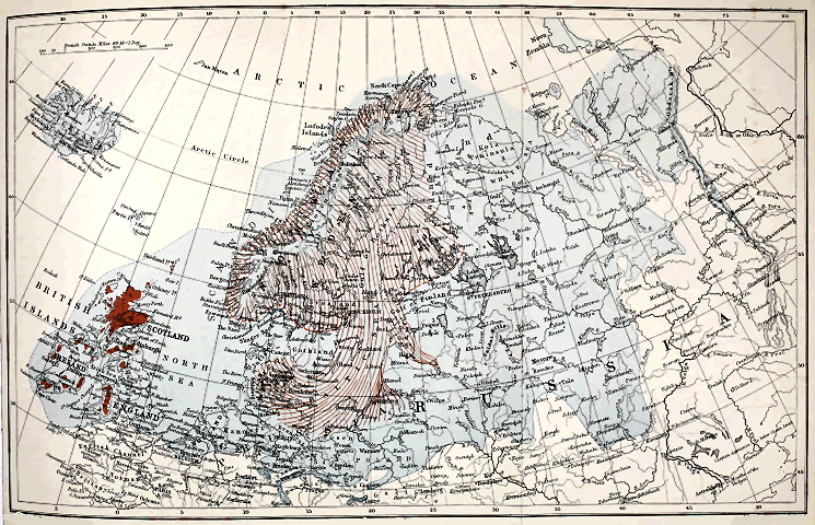
The Edinberg Geographical Institute J. G. Bartholemew, F.R.G.S.
Click on image to view larger size image.
NOTE TO COLOURING.
Maximum Glaciation Great Baltic Glacier and Local Ice-Sheets


Explanation of Plate IV.
Map of Europe showing the areas occupied by ice during the Epoch of Maximum Glaciation (Second Glacial Epoch), and the extent of glaciation in Scandinavia, Finland, Baltic coast-lands, etc., and the British Islands during the Fourth Glacial Epoch. For the limits of the greater glaciation on the Continent, Habenicht, Penck, Nikitin, and Nathorst have been followed. The Great Baltic Glacier is chiefly after De Geer.
XI.
The Geographical Evolution of Europe.[DF]
It is one of the commonplaces of geology that the Present is built up out of the ruins of the Past. Every rock beneath our feet has its story of change to tell us. Mountains, valleys, and plains, continents and islands, have passed through vicissitudes innumerable, and bear within them the evidence of a gradual development or evolution. Looking back through the vista of the past one sees the dry lands gradually separating from the ocean, and gathering together into continental masses according to a definite plan. It is this slow growth, this august evolution, carried on through countless æons, which most impresses the student of physical geology. The earth seems for the time as if endowed with life, and like a plant or animal to pass through its successive stages of development until it culminates in the present beautiful world. This conception is one of comparatively recent growth in the history of geological science. Hutton, the father of physical geology, had indeed clearly perceived that the dry lands of the globe were largely composed of the débris of former land-surfaces—that there had been alternate elevations and depressions of the earth’s crust, causing now sea and now land to predominate over given areas. But the facts known in this day could not possibly have suggested those modern ideas of geographical evolution, which are the outcome of the multifarious observation and research of later years. It is to Professor Dana, the eminent American geologist, that we are indebted for the first clear enunciation of the views which I am now about to illustrate. According to him the great oceanic basins and continental ridges are of primeval antiquity—their origin is older than that of our oldest sedimentary formations. It is not maintained that the present lands have always continued above the level of the sea. On the contrary, it can be proved that many oscillations of level have taken place within each continental area, by which the extent and outline of the land have been modified again and again. Notwithstanding such changes, however, the great continental ridges would appear to have persisted from the earliest geological times as dominant elevations of the earth’s crust. Some portions of these, as Dana remarks, may have been submerged for thousands of feet, but the continents have never changed places with the oceans.
I shall presently indicate the nature of the evidence by which it is sought to prove the vast age of our continental masses, but before doing so it will be well to give an outline of the facts which go to show that the oceanic depressions of the globe are likewise of primeval antiquity.
The memorable voyage of the Challenger has done much to increase our knowledge of the deep seas and the accumulations forming therein. The researches of the scientific staff of the expedition, and more particularly those of Mr. Murray, have indeed given a new impulse to the study of the larger questions of physical geology, and have lent strong support to the doctrine of the permanence of the oceanic basins and continental ridges. One of the most important facts brought before our attention by Mr. Murray is the absence of any land-derived materials from the sediments now gathering in the deeper abysses of the ocean. The coasts of continents and continental islands are strewn, as every one knows, with the wreck of the land—with gravel, sand, and mud, derived from the demolition of our rocks and soils. The coarser débris accumulates upon beaches and in shallow littoral waters, while the finer materials are swept further out to sea by tidal and other currents—the sediment being gradually sifted as it is borne outwards into deeper water, until only the finest mud and silt remain to be swept forward. As the floor of the ocean shelves down to greater depths the transporting power of currents gradually lessens, and finally land-derived sediment ceases to appear. Such terrigenous materials may be said to extend from the littoral zone down to depths of 2000 feet and more, and to a distance of 60 to 300 miles from shore. They are confined, therefore, to a comparatively narrow belt round the margins of continents and islands. And thus there are vast regions of the oceanic depressions over which no terrigenous or land-derived materials are accumulating. Instead of these we meet with a remarkable red clay and various kinds of ooze, made up largely of the shells of foraminifera, pelagic mollusca, and radiolarians, and the frustules of diatoms. The red clay is the most widely distributed of abysmal deposits. Indeed, it seems to form a certain proportion of all the deep-sea organic oozes, and may be said, therefore, to exist everywhere in the abysmal regions of the oceanic basins. It is extremely fine-grained, and owes its deep brown or red colour to the presence of the oxides of manganese and iron. Scattered through the deposit occur particles of various minerals of volcanic origin, together with lapilli and fragments of pumice, i.e., volcanic ejectamenta. Such materials may have been thrown out from terrestrial volcanoes and carried by the winds or floated by currents until they became water-logged and sank; or they may to some extent be the relics of submarine eruptions. Whatever may have been their immediate source, they are unquestionably of volcanic origin, and are not associated with any truly terrigenous sediment. The red clay is evidently the result of the chemical action of sea-water on volcanic products; and many facts conspire to show that its formation is an extremely slow process. Thus, remains of vertebrates, consisting of the ear-bones of whales, beaks of ziphius, and teeth of sharks, are often plentifully present, and there is no reason to suppose, as MM. Murray and Renard point out, that the parts of the ocean where these remains occur are more frequented by whales and sharks than other regions where similar relics are rarely or never dredged up. Of these remains some have all the appearance of having lain upon the sea-bottom for a very long time, for they belong to extinct species, and are either partially coated or entirely surrounded with thick layers of manganese-iron. In the same red clay occur small metallic spherules which are of cosmic origin—in other words, meteoric dust. The accumulation of all these substances in such relatively great abundance shows us that the oceanic basins have remained unchanged for a vast period of time, and assures us that the formation of the abysmal red clay is extremely slow.
When we come to examine the rocks which enter into the framework of our continents, we find that they may be roughly classed under these heads:—
1st, Terrestrial and Aqueous Rocks. 2d, Igneous Rocks. 3d, Crystalline Schists.
By far the largest areas of land are composed of rocks belonging to the first class. These consist chiefly of the more or less indurated sediments of ancient rivers, lakes, and seas—namely, conglomerate, sandstone, shale, limestone, etc. And now and again, interstratified with such aqueous beds, we meet with rocks of terrestrial origin, such as lignite, coal, and the débris of former glacial action. Now, most of our aqueous rocks have been accumulated in the sea, and thus we arrive at the conclusion that the present continental areas have from time to time been largely submerged—that the sea has frequently covered what are now the dry lands of the globe. But one remarkable fact stands out, and it is this: Nowhere amongst the sedimentary rocks of the earth’s crust do we meet with any ancient sediments which can be likened to the red clay now slowly accumulating in the deeper abysses of the ocean. There are no rocks of abysmal origin. Many of our limestones have undoubtedly formed in deep, clear water, but none of these is abysmal. Portions of Europe may now and again have been submerged for several thousand feet, but no part of this or any other continent, so far as we yet know, has within geological time been depressed to depths comparable to those of the present oceanic basins. Nay, by far the larger portions of our marine formations have accumulated in comparatively shallow water—sandstones and shales (sand and mud) being by far the most common kinds of rock that we encounter. In short, aqueous strata have, as a rule, been deposited at no great depth and at no great distance from dry land; the rocks are built up mostly of terrigenous material; and even the purer limestones and chalks, which we may suppose accumulated in seas of moderate depth, not infrequently contain some terrestrial relic which has been drifted out to sea, and afford other evidence to show that the nearest land was never very far away. Followed along their outcrop such rocks sooner or later become mixed and interbedded with ordinary sedimentary matter. Thus, for example, the thick carboniferous limestone of Wales and the Midlands of England must have accumulated in the clear water of a moderately deep sea. But when this limestone is traced north into Northumberland it begins to receive intercalations of sandstone and shale, which become more and more important, until in Scotland they form by much the larger portion of the series—the enormous thick limestones of the south being represented by only a few inconsiderable beds, included, along with seams of ironstone and coal, in a thick succession of sandstones and shales.
Of the igneous rocks and the crystalline schists I need not speak at present, but I shall have something to say about them before I have done.
Having learned that no truly abysmal rocks enter into the composition of our continents, of what kind of rocks, we may ask, are the islands composed? Well, some of those islands are built up of precisely the same materials as we find in the continents. This is the case with most islands which are not separated from continental areas by profoundly deep seas. Thus our own islands with their numerous satellites are geologically one with the adjacent continent. Their present separation is a mere accident. Were the European area, with the adjacent sea-bed, to be elevated for a few hundred feet we should find that Britain and Ireland form geologically part and parcel of the continent. And the same is the case with Nova Zembla and Spitzbergen in the north, and with the Mediterranean islands in the south. There is another large class of islands, however, which are characterised by the total absence of any of those sedimentary rocks of which, as I have just said, our continents and continental islands are chiefly built up. The islands referred to are scattered over the bosom of the great ocean, and are surrounded by profoundly deep water. Some are apparently composed entirely of coral, others are of volcanic origin, and yet others are formed partly of volcanic rock and partly of coral. Thus we have two distinct kinds of island:—
1st, Islands which have at one time evidently been connected with adjacent continents, and which are therefore termed continental islands; and
2d, Oceanic islands, which rise, as it were, from profound depths in the sea, and which have never formed part of the continents.
The fauna and flora of the former class agree with those of the neighbouring continents, although some modifications are met with, especially when the insulation has been of long standing. When such has been the case the species of plants and animals may be almost entirely distinct. Nevertheless, such ancient continental islands agree with those which have been separated in more recent geological times in containing both indigenous amphibians and mammals. Oceanic islands, on the other hand, contain no indigenous mammals or amphibians, their life consisting chiefly of insects and birds, and usually some reptiles—just such a fauna as might have been introduced by the influence of winds and of oceanic currents carrying driftwood.
Such facts, as have now been briefly summarised, point clearly to the conclusion that the oceanic basins and continental areas are of primeval antiquity. All the geological facts go to prove that abysmal waters have never prevailed over the regions now occupied by dry land; nor is there any evidence to show that continental land-masses ever existed in what are now the deepest portions of the ocean. The islets dotted over the surface of the Pacific and the other great seas are not the relics of a vast submerged continent. They are either the tops of submarine volcanic mountains, or they are coral structures founded upon the shoulders of degraded volcanoes and mountain-chains, and built up to the surface by the indefatigable labours of the humble polyp. We come then to the general conclusion that oceanic basins and intervening continental ridges are great primeval wrinkles in the earth’s crust—that they are due to the sinking down of that crust upon the cooling and contracting nucleus. These vast wrinkles had come into existence long before the formation of our oldest geological strata. All our rocks may, in short, be looked upon as forming a mere superficial skin covering and concealing the crystalline materials which no doubt formed the original surface of the earth’s crust.
Having premised so much, let me now turn to consider the geological history of our own Continent, and endeavour to trace out the various stages in its evolution. Of course I can only do so in a very brief and general manner; it is impossible to go into details. We shall find, however, that the history of the evolution of Europe, even when sketched in outline, is one full of instruction for students of physical geography, and that it amply bears out the view of the permanency of the greater features of the earth’s surface.
The oldest rocks that we know of are the crystalline schists and gneiss, belonging to what is called the Archæan system. The origin of these rocks is still a matter of controversy—some holding them to be part of the primeval crust of the globe, or the chemical precipitates of a primeval ocean, others maintaining that they are altered or metamorphosed rocks of diverse origin, a large proportion having consisted originally of aqueous or sedimentary rocks, such as sandstone and shale; while not a few are supposed to have been originally eruptive igneous rocks. According to some geologists, therefore, the Archæan rocks represent the earliest sediments deposited over the continental ridges. It is supposed that here and there those ridges rose above the surface of what may have been a boiling or highly-heated ocean, from whose waters copious chemical precipitations took place, while gravel and shingle gathered around the shores of the primeval lands. According to other writers, however, the Archæan rocks were probably accumulated under normal conditions. They consist, it is contended, partly of sediment washed down from some ancient land-surface, and distributed over the floor of an old sea (just as sediments are being transported and deposited in our own day), and partly of ancient igneous rocks. Their present character is attributed to subsequent changes, superinduced by heat and pressure, at a time when the masses in question were deeply buried under later formations, which have since been washed away. In a word, we are still quite uncertain as to the true origin of the Archæan rocks. Not infrequently they show a bedded structure, and in that respect they simulate the appearance of strata of sedimentary origin. It is very doubtful, however, whether this “bedded structure” is any evidence of an original aqueous arrangement. We know now that an appearance of bedding has been induced in originally amorphous rocks during great earth-movements. Granite masses, for example, have been so crushed and squeezed as to assume a bedded aspect, and a similar structure has been developed in many other kinds of rock subjected to enormous pressure. Whatever may have been the origin of the bedded structure of the Archæan rocks, it is certain that the masses have been tilted up and convoluted in the most remarkable manner. Hitherto they have yielded no unequivocal trace of organic remains—the famous Eozoon being now generally considered as of purely mineral origin. The physical conditions under which the Archæan gneiss and schist came into existence are thus quite undetermined, but geologists are agreed that the earliest land-surfaces, of the former existence of which we can be quite certain, were composed of rocks. And this brings us to the beginning of reliable geological history.
All subsequent geological time—that, namely, of which we have any record preserved in the fossiliferous strata—is divided into four great eras, namely the Palæozoic, the Mesozoic, the Cainozoic, and the Post-Tertiary eras, each of which embraces various periods, as follows:—
Post-Tertiary Recent. Pleistocene.

Tertiary or Cainozoic Pliocene. Miocene. Oligocene. Eocene.
Secondary or Mesozoic Cretaceous. Jurassic. Triassic.
Primary or Palæozoic Permian. Carboniferous. Devonian and Old Red Sandstone. Silurian. Cambrian.
Archæan, . Fundamental Gneiss.
Leaving the Archæan, we find that the next oldest strata are those which were accumulated during the Cambrian period, to which succeeded the Silurian, the Devonian and Old Red Sandstone, the Carboniferous, and the Permian periods—all represented by great thicknesses of strata, which overspread wide regions.
Now, at the beginning of the Cambrian period, we have evidence to show that the primeval continental ridge was still largely under water, the dry land being massed chiefly in the north. At that distant date a broad land-surface extended from the Outer Hebrides north-eastwards through Scandinavia, Finland, and northern Russia. How much further north and north-west of the present limits of Europe that ancient land may have extended we cannot tell, but it probably occupied wide regions which are now submerged in the shallow waters of the Arctic Ocean. In the north of Scotland a large inland sea or lake existed in Cambrian times,[DG] and there is some evidence to suggest that similar lacustrine conditions may have obtained in the Welsh area at the beginning of the period. South of the northern land lay a shallow sea covering all middle and southern Europe. That sea, however, was dotted here and there with a few islands of Archæan rocks, occupying the site of what are now some of the hills of middle Germany, such as the Riesen Gebirge, the Erz Gebirge, the Fichtel Gebirge, etc., and possibly some of the Archæan districts of France and the Iberian peninsula.