Front matter (continued 3)
Reading edition
Fig. 8.—s, Silurian strata; i, Cheviot Igneous Rocks (Lower Old Red Sandstone); r, Upper Old Red Sandstone series; c, Kelso Igneous Rocks (Lower Carboniferous); d, Lower Carboniferous Sandstones, Shales, etc.

I come now to speak of certain rocks which, although they are developed chiefly beyond the limits of our district, yet require a little consideration before we can complete our account of the geological history of the Cheviots. The rocks referred to consist chiefly of old lava-beds, which very closely resemble those of the Lower Old Red Sandstone. They appear on the south side of the Tweed valley below Kelso, whence they extend south-west and west, crossing the river at Makerstoun, and sweeping north to form the hills about Smailholm, Stichill, and Hume (Fig. 8). All to the east of these rocks, the valley of the Tweed is occupied by a great thickness of grey sandstones, and grey and blue shales and clays, with which are associated thin cement-stone bands, and occasional coarse sandy limestones called cornstone. These strata rest upon the outskirts of the Kelso igneous rocks, and are clearly of later date than these, since in their lower beds, which are often conglomeratic, we find numerous rounded fragments of the igneous rocks upon which the sandstones and shales abut. The latter have yielded a number of fossils, both animals and plants, to which I shall refer presently. In the bed of the Teviot near Roxburgh, and elsewhere, the Kelso igneous rocks are found reposing upon whitish and reddish sandstones, which are evidently the upper members of the red beds of the Jed Water and other localities.
Strata closely resembling the grey sandstones and shales of the Tweed valley appear among the Cheviot Hills at the head of the Jed Water, where they are marked by the presence of thick massive sandstones, which form all the tops of the hills between Hungry Law and the heights that overlook the sources of the Liddel Water—the greatest height reached being at Carter Fell, which is 1815 feet above the sea-level. The strata at this place contain some impure limestone and thin seams of coal, while beds of lava and tuff appear intercalated in the series.
Fig. 9.—Section across old volcanic neck. The dotted line above suggests the original form of the volcano; b, plug of igneous rock which rose in a molten state and cooled in the vent.
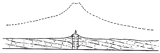
Now let us rapidly sum up what seem to be the inferences suggested by these briefly-stated facts. We have seen that the Upper Old Red Sandstone began to be deposited in a lake which, as time wore on, probably communicated with the sea, while the land was undergoing a process of depression, so that the area of deposition was thus widely increased, and sediment gradually accumulated in places and at levels which had existed as land when the ancient lake first appeared in the Cheviot district. The old lava-beds of Kelso show that the volcanic forces, which had long been quiescent, again became active. Great floods of molten matter issued from the bowels of the earth, and poured over the bottom of the inland sea. But all the larger volcanoes of this period were confined to the centre of the Tweed valley. Not a few little isolated volcanoes, however, seem to have dotted the sea-bottom beyond the limits of the Kelso area. From these, showers of stones were ejected, and sometimes also they poured out molten matter. Their sites are now represented by rounded hills which stand up, more or less abruptly, above the level of the undulating tracts in which they occur (Fig. 9). Among the most marked are Rubers Law, Black Law, the Dunian, and Lanton Hill. Of course it is only the plugged-up vents or necks that now remain; all the loose ejectamenta by which these must at one time have been surrounded have long since been worn and washed away. At last the Kelso volcanoes became extinct, and the little ones also probably died out at the same time. Another long period now ensued, during which the inland sea disappeared, and its dried-up bed was subjected to the denuding action of the sub-aërial forces. The volcanic rocks of the Kelso district suffered considerable erosion, while the softer sandy strata amongst which they were erupted no doubt experienced still greater waste. Ere long, however, the scene again changes; and what is now the vale of Tweed becomes a wide estuary, the shores of which are formed at first by the Kelso igneous rocks. Into this estuary, rivers and streams carry the spoil of the Southern Uplands, and strew its bed with sand and mud. Occasionally ferns and large coniferous trees are floated down, and, getting water-logged, sink to the bottom, where they become entombed in the slowly accumulating sediment. The character of these buried plants shows that the climate must have been genial. They belong to species which are characteristic of the Carboniferous system, and we look upon them with interest as the forerunners of that vast plant-growth which by-and-by was to cover wide areas in Britain, and to give rise to our coal-seams, the source of so much national wealth. In the waters of the estuary, minute crustaceous creatures called cyprides abounded, and with these was associated a number of small molluscs, chiefly univalves. Here and there considerable quantities of calcareous mud and sand gathered on the bed of the estuary, and formed in time beds of cement-stone, and impure limestone or cornstone. How long that condition of things obtained in the Tweed valley we cannot tell; but we know that after a very considerable thickness of sediment had accumulated, estuarine conditions prevailed over the south-west end of what is now the Cheviot range. This points to a considerable depression of the land. In this same region volcanic action appeared, and streams of lava and showers of fragmental materials were ejected—the remains of which are seen in Hungry Law, Catcleugh Shin, and the head-waters of the Jed. Genial climatic conditions continued; and here and there, along what were either low islets or the flat muddy shores of the estuary, plants grew in sufficient quantity to form masses of vegetation which, subsequently buried under mud and sand, were compressed and mineralised, and so became coal. The only place where these are now met with is on the crest of the Cheviots at Carter Fell. The process of depression still continuing, thick sand gradually spread over the site of the submerged forests. To trace the physical history immediately after this, we must go out of the Cheviot district; and it may suffice if I merely state that these estuarine or lacustrine conditions, which prevailed for a long time not only over the Tweed and Cheviot areas but in various other parts of Scotland, at last gave place to the sea. In this sea, corals, sea-lilies, and numerous molluscs and fishes abounded—all pointing to the prevalence of genial climatic conditions. The organic remains and the geological position of the estuarine beds of the Tweed and the Cheviots—resting as they do upon the Upper Old Red Sandstone—prove them to belong to the Lower series of the great Carboniferous system.
It was some time during the Carboniferous period that wide sheets of melted matter were forcibly intruded among the Old Red Sandstone and the Lower Carboniferous strata of the Cheviot district; but although these are now visible at the surface, as at Southdean, Bonchester, etc., they never actually reached that surface at the time of their irruption. They cooled in the crust of the earth amongst the strata between which they were intruded, and have only been exposed to view by the action of the denuding forces which have worn away the sedimentary beds by which they were formerly covered.
A very wide blank next occurs in the geological history of the Cheviots. We have no trace of the many great systems, comprising vast series of strata and representing long eras of time, which we know, from the evidence supplied by other regions, followed after the deposition of the Lower Carboniferous strata. The Middle and Upper Carboniferous groups are totally wanting, so likewise is the Permian system; and all the great series of “Secondary” systems, of which the major portion of England is composed, are equally absent. Nay, even Tertiary accumulations are wanting. There is one very remarkable relic, however, of Tertiary times, and that is a long dyke or vertical wall of basalt-rock which traverses the country from east to west, crossing the crest of the Cheviots near Brownhart Law, and striking west by north through Belling Hill, by the Rule Water at Hallrule Mill, on towards Hawick. This is one of a series of such dykes, common enough in some parts of Scotland, which become more numerous as we approach the west coast, where they are found associated with certain volcanic rocks of Tertiary age, in such a way as to lead to the belief that they all belong to the same period. The melted rock seems to have risen and cooled in great cracks or fissures, and seldom to have overflowed at the surface. Indeed it is highly probable that many or even most of the dykes never reached the surface at all, but have been exposed by subsequent denudation of the rocks that once overlaid them. Such would appear to have been the case with the great dyke of the Cheviot district.
We can only conjecture what the condition of this part of southern Scotland was in the long ages that elapsed between the termination of the Lower Carboniferous period and the close of the Tertiary ages. It is more than likely that it shared in some of the submergences that ensued during the deposition of the upper group of the Carboniferous system; but after that it may have remained, for aught we can tell, in the condition of dry land all through those prolonged periods which are unrecorded in the rocks of the Cheviot Hills, but have left behind them such noteworthy remains in England and other countries. Of one thing we may be sure, that during a large part of those unrecorded ages the Cheviot district could not have been an area of deposition. Rather must it have existed for untold eras as dry land; and this explains and accounts for the enormous denudation which the whole country has experienced; for there can be little doubt that the Lower Carboniferous strata of Carter Fell were at one time continuous with the similar strata of the lower reaches of the Tweed valley. Yet hardly a trace of the missing beds remains in any part of the country between the ridge of the hills at the head of the Jed Water and the Tweed at Kelso. Only little patches are found capping the high ground opposite Jedburgh, as at Hunthill, etc. Thus more than a thousand feet of Lower Carboniferous strata, and probably not less than five hundred or six hundred feet of Old Red Sandstone rocks, have been slowly carried away, grain by grain, from the face of the Cheviot district since the close of the Lower Carboniferous period.
IV.
In the first of these papers some reference was made to the configuration of the ground in the Cheviot district. We have seen that the outlines assumed by the country have been determined in large measure by the nature of the rocks. Thus where igneous masses abound, the hills present a more or less irregular, and broken or lumpy contour, while the valleys are frequently narrow and deep. In the tracts occupied by Silurian strata, we have, as a rule, broad-topped hill-masses with a smoothly-rounded outline, whose slopes generally fall away with a long gentle sweep into soft green valleys, along the bottoms of which the streams often flow in deep gullies and ravines. Where the country is formed of sandstones, and other associated strata, the hills are generally broad and well-rounded, but the outline is not infrequently interrupted by lines of cliff and escarpment. These strata, however, are confined chiefly to the low-grounds, where they form a gently-undulating country, broken here and there, as in Dunian Hill, Bonchester Hill, Rubers Law, etc., by abrupt cones and knobs of igneous rock.
It is evident, then, that the diversified character of the Cheviot Hills and the adjoining low-grounds depends on the character of the rocks and also, as we shall see presently, upon geological structure. Each kind of rock has its own peculiar mode of weathering. All do not crumble away under the action of rain, frost, and running water in precisely the same manner. Some which yield equally and uniformly give rise to smooth outlines, others of more irregular composition, such as many igneous rocks, break up and crumble unequally in a capricious and eccentric way, and these in the course of time present a hummocky, lumpy, and rough irregular configuration. And as soft and readily-weathered rocks must wear away more rapidly than indurated and durable masses, it follows that the former will now be found most abundantly at low levels, while the latter will enter most extensively into the composition of the hills. But the contour of a country depends not only upon the relative durability of the rocks, but also upon the mode of their occurrence in the crust of the earth. Strata, as we have seen, do not all lie in one way; some are horizontal, others are inclined to the horizon, while yet others are vertical. Again, many rocks are amorphous; that is to say, they occur in somewhat thick masses which show no trace of a bedded arrangement. Such differences of structure and arrangement influence in no small degree the weathering and denudation of rocks, and cannot be left out of account when we are seeking to discover the origin of the present configuration of our hills and valleys. Thus, escarpments and the terraced aspect of many hill-slopes are due to inequalities in the strata of which such hills are built up. The softer strata crumble away more rapidly under the touch of the atmospheric forces than the harder beds which rest upon them, and hence the latter are undermined, and their exposed ends or crops, losing support, fall away and roll down the slopes. The igneous rocks of the Cheviots are arranged in beds; but so massive are these, that frequently a hill proves to be composed from base to summit of one and the same sheet of old lava. Hence there is a general absence of that terraced aspect which is so conspicuous in hills that are built up of bedded rock-masses. Here and there, however, the beds are not so massive, several cropping out upon a hill-side; and whenever this is the case (as near Yetholm) we find the hill-slopes presenting the usual terraced appearance—a series of cliffs and escarpments, separated by intervening slopes, rising one above the other. In the Silurian districts no such terraces or escarpments exist, the general high dip of the strata, which often approaches the vertical, precluding any such contour. In a region composed of highly-inclined greywacké and shale, however, we should expect to find that where the strata are of unequal durability, the harder beds will stand up in long narrow ridges, separated by intervening hollows, which have been worn out along the outcrops of the softer and more easily-denuded beds. And such appearances do show themselves in some parts of the Silurian area. As a rule, however, the Silurian strata are not thick-bedded, and harder and softer bands alternate so rapidly that they yield on the whole a smooth surface under the action of the atmospheric forces. In the low-lying districts, which, as I have said, are mostly occupied by sandstones and shaly beds, all the abrupt isolated hills are formed of igneous rocks, which are much harder and tougher than the strata that surround them. It is quite evident that these hills owe their present appearance to the durable nature of their constituent rocks, which now project above the general level of the surface, simply because they have been better able to resist the denuding agents than the softer rocks that once covered and concealed them.
We see, then, that each kind of rock has its own particular mode of weathering, and that the configuration of a country depends primarily upon this and upon geological structure. Indeed, so close is the connection between the geology and the surface-outline of a country, that to a practised observer the latter acts as an unfailing index to the general nature of the underlying rocks, and tells him at a glance whether these are igneous like basalt and porphyrite, aqueous like sandstone and shale, or hardened and altered strata like greywacké. But while one cannot help noticing how in the Cheviot district the character of the scenery depends largely upon the nature and structure of the rocks, he shall, nevertheless, hardly fail to observe that flowing outlines are more or less conspicuous over all the region. And as he descends into the main valleys, he shall be struck with the fact that the hill-slopes seem to be smoothed off in a direction that coincides with the trend of these valleys. In short, he cannot help noticing that the varied configuration that results from the weathering of different rock-masses has been subsequently modified by some agent which seems to have acted universally over the whole country. In the upper reaches of the Cheviot valleys, the rocks have evidently been rounded off by some force pressing upon them in a direction coinciding with that of the valleys; but soon after entering upon their lower reaches, we notice that the denuding or moulding force must have turned gradually away to the north-east—the northern spurs of the Cheviots, and the low-grounds that abut upon these being smoothed off in a direction that corresponds exactly with the trend of that great strath through which flow the Teviot and the Tweed, from Melrose downwards. Throughout this broad strath, which extends from the base of the Lammermuirs to the foot of the Cheviots, and includes the whole of Teviotdale, the ground presents a remarkable closely-wrinkled surface, the ridges and intervening hollows all coinciding in direction with the general trend of the great strath, which is south-west and north-east; but turning gradually round to east, as we approach the lower reaches of the Tweed.
Passing round the north-eastern extremity of the Cheviot range into Northumberland, we observe that the same series of ridges and hollows continues to follow an easterly direction until we near the sea-board, when the trend gradually swings round to the south-east, as in the neighbourhood of Belford and Bamborough, where the ridges run parallel with the coast-line.
The ridges and hollows are most conspicuous in the low-grounds of Roxburghshire and Berwickshire, especially in the regions between Kelso and Smailholm, and between Duns and Coldstream. The dwellers along the banks of the Tweed are quite familiar with the fact that the roads which run parallel with the river are smooth and level, for they coincide with the trend of the ridges and hollows; whilst those that cross the country at right angles to this direction must of course traverse ridge after ridge, and are therefore exceedingly uneven. In this low-lying district most of the ridges are composed of superficial deposits of stony and gravelly clay and sand, and the same is the case with those that sweep round the north-eastern spurs of the Cheviots by Coldstream and Ancroft. Some ridges, however, consist either of solid rock alone, as near Stichill, or of rock and overlying masses of clay and stones. In the hilly regions, again, nearly all the ridges are of rock alone, especially in the districts lying between Melrose and Selkirk and between Selkirk and Hawick. Indeed, the hills drained by the upper reaches of the Teviot and its tributaries are more or less fluted and channelled, as it were—many long parallel narrow hollows having been driven out along their slopes and even frequently across their broad tops. This scolloped and ridged aspect of the hills, however, disappears as we approach the upper reaches of the hill-valleys. From Skelfhill Pen (1745 feet) by Windburgh Hill (1662 feet), on through the ridge of the Cheviot watershed, none of the hills shows any appearance of a uniformly-wrinkled surface.
Fig. 10.—Rounded Rocks, with superficial deposits, t t t, heaped up against steep faces. The arrows indicate direction followed by the smoothing agent.

A close inspection of the rock-ridges satisfies one that they have been smoothed off by some agent pressing upon them in a direction that coincides with their own trend; and not only so, but the smoothing agent, it is clearly seen, must have come from the watersheds and then pressed outwards to the low-grounds which are now watered by the Teviot and the Tweed. This is shown by the manner in which the rocks have been smoothed off, for their smooth faces look towards the dominant watersheds, while their rough and unpolished sides point away in the opposite direction. Sometimes, however, we find that more or less steeply projecting rocks face the dominant watersheds. When such is the case, there is usually a long sloping “tail” behind the crag—a “tail” which is composed chiefly of superficial deposits. The hills between Hume and Stichill afford some good examples. The two kinds of appearances are exhibited in the accompanying diagram (Figs. 10, 11.) The appearance shown in Fig. 10 is of most common occurrence in the upland parts of the country, while “crag and tail” (as shown in Fig. 11) is seen to greatest advantage in the open low-grounds. In both cases it will be observed that superficial deposits (t) nestle behind a more or less steep face of rock.
Fig. 11.—“Crag and Tail”; boss of hard rock, c; intersecting sandstones, s; superficial deposits heaped up in rear of crag, t. The arrow indicates direction followed by smoothing agent.

When the rocks have not been much exposed to the action of the weather, they often show a polished surface covered with long parallel grooves and striæ or scratches. Such polished and scratched surfaces are best seen when the superficial deposits have been only recently removed. Often, too, when we tear away the thick turf that mantles the hill-slopes, we find the same phenomena. Indeed, wherever the rocks have not been much acted upon by the weather, and thus broken up and decomposed, we may expect to meet with more or less well-marked grooves and stride. Now the remarkable circumstance about these scratches is this—they agree in direction with the trend of the rock-ridges and the hollows described above. Nor can we doubt that the superficial markings have all been produced by one and the same agent. In the upper valleys of the Cheviots, the scratches coincide in direction with the valleys, which is, speaking generally, from south to north, but as we approach the low-grounds they begin to turn more to the east (just, as we have seen, is the case with the ridges and hollows), until we enter England to the east of Coldstream, where the striæ point first nearly due east, but eventually swing round to the south-east, as is well seen upon the limestone rocks between Lowick and Belford. In Teviotdale the general trend of the striæ is from south-west to north-east, a direction which continues to hold good until the lower reaches of the Tweed are approached, when, as we have just mentioned, they begin to turn more and more to the east. Thus it becomes evident that the denuding agent, whatever it was, that gave rise to these ridges and scratched rock-surfaces must have pressed outwards from all the dominant watersheds, and, sweeping down through the great undulating strath that lies between the Cheviots and the Lammermuirs, must have gradually turned away to the east and south as it rounded the northern spurs of the former range, so as to pass south-east over the contiguous maritime districts of Northumberland.
A few words now as to the character of the superficial deposits which enter so largely into the composition of the long parallel banks and ridges in the low-grounds of Roxburghshire, Berwickshire, and the northern part of Northumberland. The most conspicuous and noteworthy deposit is a hard tough tenacious clay, which is always more or less well-charged with blunted and sub-angular stones and boulders, scattered pell-mell through the mass. This clay is as a rule quite unstratified—it shows no lines of bedding, and although here and there it contains irregular patches and beds of gravel and sand, yet it evidently does not owe its origin to the action of water. Its colour in the upper part of Teviotdale and the Cheviots is generally a drab-brown, or pale grey and sometimes yellow, while here and there, as in the upper reaches of the Jed valley, it is a dark dingy bluish grey. In the lower parts of Teviotdale and in the Tweed district it is generally red or reddish brown. The stones in the clay have all been derived from the rocks of the region in which it occurs. Thus in Teviotdale we find that in the higher reaches of the dale which are Silurian the stones and boulders consist of various kinds of greywacké, etc. In the lower reaches, however, when we pass into the Red Sandstone area, we note that the clay begins to contain fragments of red sandstone, while the clay itself takes on a reddish tinge, until we get down to the vale of the Tweed, where not only is the clay very decidedly red, but its sandstone boulders also are very numerous. The same appearances present themselves in passing outwards from the Cheviots. At first the clay contains only stones that have been derived from the upper parts of the hills, but by-and-by, as we near the low-grounds, other kinds begin to make their appearance, so that by the time we reach the Tweed we may obtain from the clay specimens of every kind of rock that occurs within the drainage-area of the Teviot and the lower reaches of the River Tweed.
Look at the stones, and you shall observe that all the harder and finer-grained specimens are well-smoothed and covered with striæ or scratches, the best marked of which run parallel with the longer axis of each stone and boulder. These scratches are evidently very similar to those markings that cover the surface of the underlying solid rock, and we may feel sure, therefore, that the denuding agent which smoothed and scratched the solid rocks had also something to do with the stones and boulders of the clay.
Underneath the stony clay, or Till, as it is called, we find here and there certain old river gravels. We know that these gravels are river-formations, because not only do they lie at the bottom of the river-valleys, but the stones, we can see, have been arranged by water running in one constant direction, and that direction is always down the valley in which the gravels chance to occur. Frequently, however, there is no trace of such underlying gravels, but the till rests directly upon the solid rocks.
Now what do all these appearances mean? It is clear that there is no natural agent in this country engaged in rounding and scratching the rocks, or in accumulating a stony clay like till. In alpine regions, however, we know that glaciers, as they slowly creep down their valleys, grind and polish and scratch the rocks over which they pass, and that underneath the moving ice one may detect smoothed and striated stones precisely resembling those that occur in till. Frost in such alpine regions splits up the rocks of the cliffs and mountain-slopes that overlook a glacier, and immense masses of angular stones and débris, thus loosened, roll down and accumulate along the flanks of the ice-streams. Eventually such accumulations are borne slowly down the valley upon the back of the glacier, and are dropped at last over the terminal front of the ice, where they become intermingled with the stones and rubbish, which are pushed or washed out from underneath the ice. These heaps and masses of angular débris and stones are called “moraines,” and one can see that in Switzerland the glaciers must at some time have been much larger, for ancient moraines occur far down in the low-grounds of that country—the glaciers being now confined to the uppermost reaches of the deep mountain-valleys. Moreover, we may note how the mountain-slopes overlooking the present puny glaciers have been rubbed by ice up to a height of sometimes a thousand feet and more above the level of the existing ice-streams. Now since the aspect presented by the glaciated rock-surfaces of Switzerland is exactly paralleled by the rounded and smoothed rocks of Scotland, there can be no doubt that the latter have had a similar origin. Again, we find throughout the low-grounds of Switzerland a deposit of till precisely resembling that which is so well developed in Teviotdale and the valley of the Tweed. And as there can be no doubt that the Swiss till has been produced by the action of glacier ice, we are compelled to believe the same of the till in Scotland.
Let us further note that in the deep mountain-valleys of Switzerland the glacial deposits consist for the most part of coarse morainic débris—of such materials, in short, as the terminal moraines of existing glaciers are mainly composed. Not infrequently this morainic débris has been more or less acted upon by the rivers that escape from the glaciers, and the angular stones have been rounded and arranged in bedded masses. It is only when we get out of the mountain-valleys and approach the low-grounds that the till, or stony clay, begins to appear abundantly. The same phenomena characterise the Cheviot district. In the upper reaches of the mountain-valleys at the heads of the Teviot, the Kale, the Bowmont, etc., either till does not occur or it is thin and often concealed below masses of rude morainic débris and gravel. Out in the low-grounds, however, till, as we have already remarked, is the most conspicuous of all the superficial deposits. From these facts it may be inferred that till indicates the former presence of great confluent glaciers, while morainic débris in hill-valleys points to the action of comparatively small local and isolated glaciers.
What, then, are the general conclusions which may be derived from a study of the rock-ridges, flutings, and striæ, and the till of the Cheviot district? Clearly this: that the whole country has at one time been deeply buried under glacier ice. The evidence shows us that the broad strath stretching between the Lammermuirs and the Cheviots must have been filled to overflowing with a great mass of ice that descended from the uplands of Peebles and Selkirk and the broad-topped heights that overlook the sources of the Teviot. The Cheviots appear to have been quite buried underneath this wide sea of ice, and so likewise were the Lammermuirs. At the same time, as we know, all Scotland was similarly enveloped in a vast sheet of snow and ice, which streamed out from the main watersheds of the country, and followed the lines of the chief straths—that is to say, the general slope of the ground. The track of the ice in the Cheviot district is very distinctly marked. In Teviotdale it followed the trend of the valley, and, grinding along the outcrop of the Silurian strata, deepened old hollows and scooped out new ones in the soft shaly beds, while the intervening harder strata, which offered greater resistance to the denuding action of the ice, did not wear so easily, and so were rounded off, and formed a series of ridges running parallel to the eroded hollows. The stones and rubbish, dragged along underneath the ice, necessarily increased as the glacier mass crept on its way. The rocks were scratched and grooved by the stones that were forced over them, and the polishing was completed by the finer sand and clay which resulted from the grinding process. Wherever a rock projected there would be a tendency for the stones and clay and sand to gather behind it. One may notice the same kind of action upon the bed of a stream, where the sediment tends to collect in the rear of prominent stones and boulders. And we can hardly fail to have observed further that the sediment of a river often arranges itself under the action of the current in long banks, which run parallel to the course of the water. Underneath the ice-sheet the stones, sand, and clay behaved in the same way. Behind projecting rocks in sheltered nooks and hollows, they accumulated, while in places exposed to the full sweep of the ice-stream they were piled up and drawn out into long parallel banks and ridges, the trend of which coincided with that of the ice-flow. The presence of confused and irregular patches and lenticular beds of sand, clay, and gravel in the till is not difficult to understand when we know that there is always more or less water flowing on underneath a glacier. Such streams must assort the débris, and roll angular fragments into rounded stones and pebbles; but the materials thus assorted in layers will ever and anon be crushed up so as to be either partially or wholly obliterated by the slowly moving glacier.
As the stones and clay were derived from the underlying rocks, it is no wonder that the colour of the till should vary. In the Silurian tracts it is pale yellowish, or bluish grey, and the stones consist chiefly of fragments of Silurian rocks, all blunted and smoothed, and often beautifully polished and striated. When we get into the Red Sandstone region of the low-grounds the colour of the clay begins by-and-by to change, and fragments of red sandstone become commingled with the Silurian stones, until ere long the colour of the deposit is decidedly red, and sandstone fragments abound. Everywhere the stones show that they have been carried persistently in one direction, and that is out from the watershed, and down the main valleys.
The direction of the ice-marks upon the solid rocks, and the trend of the “drums,” as the parallel ridges of till are termed, show that the ice-sheet of Teviotdale and Tweed gradually turned away to the east and south-east as it swept round the north-eastern spurs of the Cheviots. Now we may well ask why the ice did not go right out into the North Sea, which is apparently the course it ought to have followed. The same curious deflection affected the great ice-stream that occupied the basin of the Forth. When it got past North Berwick, that stream, instead of flowing directly east into the North Sea, turned away to the south-east and overflowed the northern spurs of the Lammermuirs, bringing with it into the valley of the Tweed stones and boulders which had travelled all the way from the Highlands. It is obvious there must have been some impediment to the flow of the Scottish ice into the basin of the North Sea. What could have blocked its passage in that direction? At the very time that Scotland lay concealed beneath its ice-sheet, Norway and Sweden were likewise smothered in ice which attained a thickness of not less than five or six thousand feet. The whole basin of the Baltic was occupied by a vast glacier which flowed south into Northern Germany, and this sheet was continuous with glacier-ice that crossed over Denmark. When we consider how shallow the North Sea is (it does not average more than forty fathoms between Scotland and the Continent), we cannot doubt that the immense masses of ice descending from Norway could not possibly have floated off, but must actually have crept across the bottom of that sea until they abutted upon and coalesced with the Scottish ice, so as to form one vast mer de glace.
Thus it was that the Scandinavian ice blocked up the path of the Scottish glaciers into the basin of the North Sea, and compelled them to flow south-east into England.[H] Had there been no such obstruction to the passage of the Scottish glaciers, it is impossible to believe that snow and ice could ever have accumulated to such a depth in Scotland. The Scottish ice reached a thickness of some three thousand feet in its deeper parts. It is evident, however, that had there been a free course for the glaciers, they would have moved off before they could have attained this thickness. And we can hardly doubt, therefore, that it was the damming-up of their outlet by the great Scandinavian ice-sheet that enabled them to deepen to such an extent in the valleys and low-grounds of Scotland.
When the ice-sheet was at its thickest, the Cheviots were completely covered, nevertheless they served to divide the ice-flow between Scotland and England, although here and there one finds that the ice passed over some of the lower summits, carrying with it boulders and stones. This is by no means an uncommon circumstance in Scotland and other glaciated countries. Thus we note that Highland boulders have been brought into the vale of the Tweed across the Lammermuirs; and in the same way boulders from the heights overlooking Eskdale have been carried over some of the lower hill-tops into the vale of the Teviot. In like manner the Swedish ice occasionally overflowed the lower mountain-tops of the dividing ridge or watershed into Norway.
What wonder now that the Cheviot area should exhibit so many flowing outlines, that the hills should be so smoothed and rounded and fluted, that the low-grounds should be cumbered with such heaps of clay and striated stones? Long before the great glaciers appeared, the rocks were weathered and worn by the action of the usual atmospheric forces, and each had assumed its own peculiar outline; but how greatly has this been modified by the grinding action of the ice-sheet! To what an extent have projecting rocks been rubbed, and how great is the destruction that has befallen the loose accumulations of river gravel, sand, and clay that gathered in the valleys before the advent of the Ice Age! All that now remains of these are a few patches preserved here and their underneath the till. The Cheviots can tell us nothing of the kinds of plants and animals that clothed and peopled the country in pre-glacial times. All we learn is that streams and rivers flowed as they flow now, and that by-and-by everything was changed, and the land disappeared underneath a vast covering of snow and ice.
In my concluding paper I will show how this ice period passed away, and how the present condition of things succeeded.
V.
I have described the condition of the Cheviot district during the climax of the Ice Age as one of intense arctic cold, the whole ridge of hills being then completely smothered in snow and ice. This excessive climate, however, did not last continuously throughout the so-called glacial period, but was interrupted by more than one mild interglacial epoch. We have evidence in Scotland, as in other countries, to show that the great confluent ice-masses melted away so as to uncover all the low-grounds and permit the reappearance of plants and animals. Rivers again watered the land, and numerous lakes diversified the face of the country. Willows, hazels, and alders grew in the sheltered valleys, oak-trees flourished in the low-grounds, and Scots firs clustered upon the hill-slopes. A strong, grassy vegetation covered wide areas, and sedges and rushes luxuriated in marshy places and encroached upon the margins of the lakes. The mammoth, or woolly-coated elephant, roamed over the land, and among its congeners were the extinct ox, the horse, the Irish elk, and the reindeer. After such a temperate condition of things had continued for some time—perhaps for thousands of years—the land, during the last interglacial epoch, became gradually submerged to a depth of several hundred feet, and a cold, ungenial sea, in which flourished species of northern and arctic shells, covered the low-grounds of Scotland. The cold continuing to increase, our glaciers descended for the last time from the mountains and encroached upon the bed of the sea, until they became confluent, fairly usurping the floor of the German Ocean, and pushing back the western seas as far as, and even beyond, the islands of the Outer Hebrides. There is good reason to believe that such great changes of climate occurred several times during the glacial period, which thus seems to have consisted of an alternation of cold and genial epochs. But as the last phase in this extraordinary series of changes was a cold one, during which great glaciers scoured the face of the country, we now obtain only a few scattered traces of the genial conditions that characterised the preceding mild interglacial epochs. Vegetable accumulations, lake and river deposits with mammalian remains, marine beds and their shelly contents, were all ploughed up by the ice, and to a very large extent demolished. Here and there, however, we find in the till or boulder-clay that marks the last cold epoch, wasted fragments of trees, tusks of mammoths, and broken sea-shells; while underneath the till we occasionally come upon old lake deposits with vegetable and mammalian remains, or, as the case may be, beds of marine origin well stocked with sea-shells of arctic species. And these freshwater and marine beds repose, in many cases, upon an older accumulation of till, which belongs to an earlier cold epoch of the glacial period. In the Cheviot district proper, the traces of mild, interglacial conditions are very slight, but in the immediate neighbourhood we find them more strongly marked. Thus, in the valley of the Slitrig, near Hawick, we notice freshwater beds with peaty matter lying between a lower and an upper till or boulder-clay; and interglacial freshwater beds also appear in the neighbouring county of Peebles, particularly in the valley of the Leithan Water. Again, in the valley of the Tweed near Carham, there occur interglacial beds in which I detected numerous bones of water-rats and frogs. These interglacial remains acquire a peculiar interest when we come to view the “superficial deposits” of Scotland in connection with those of England and the Continent; for, as I have endeavoured to show elsewhere,[I] it is most likely that the ancient gravels of England, which contain the earliest traces of man, belong for the most part to interglacial times; and the extraordinary changes of climate described above may therefore have been actually witnessed by human eyes. Indeed, I believe it was the advent of the last cold epoch of the Ice Age that drove out the old tribes who used the rude flint implements that are now found in the gravel deposits and caves of England, and who occupied the British area along with hippopotami, rhinoceroses, elephants, lions, hyænas, and other animals. The men who entered Britain after the final disappearance of arctic conditions, were more advanced in civilisation, and were accompanied by a very different assemblage of animals—by a group represented by oxen, sheep, dogs, and other creatures, most of which are still indigenous to Britain.
But to return to the Cheviots. When the final cold epoch had reached its climax, and the ice-sheet began to melt away for the last time, the tops of the hills then once more became uncovered, and large blocks, detached by the action of the frost, fell upon the surface of the glaciers, and were borne down the valleys, some of them to become stranded here and there on hill-slopes, others to be carried far away from the Cheviot area and dropped at last over Northumberland and Durham, or even further south. As the melting of the ice continued, and the glacier of the Tweed ceased to reach the sea, great accumulations of gravel and sand were formed. Underneath the ice, sub-glacial streams ploughed out the till, and paved their hidden courses with gravel and sand. In summer-time, the whole surface of the Tweed glacier was abundantly washed with water, which, pouring down by clefts and holes in the ice, swelled all the sub-glacial streams and rivers. At the same time, floods descending from the Lammermuirs and the Cheviots, pushed with them vast quantities of shingle, gravel, and sand, part of which was swept upon the surface of the Tweed glacier, while much seems to have gathered along its flanks, forming banks and ridges running parallel with the course of the valley.
At last the time came when the ice had fairly vanished from the lower reaches of the Tweed, and we now walk over its bed and mark the long ridges and banks of shingle and gravel that were formed by the sub-glacial streams and rivers, and the somewhat similar accumulations that gathered along the sides of the glacier at the foot of the Lammermuir Hills. Here and there, also, we note the heaps (i.e. moraines) of shingle, earth, clay, and débris, with large erratics which travelled on the surface of the ice, and were dropped upon the ground as that ice melted away. All the loose erratics that lie at the surface in the lower reaches of the Tweed valley have come from the west. Some of them rest upon hard rock, others upon till, and yet others crown the tops and slopes of gravel and sand hillocks, or appear in low mounds of morainic origin.
In the valleys of the Cheviot Hills one traces the footsteps of the retiring glaciers in mounds and hummocks of rude earthy débris, blocks, and rock-rubbish. These are terminal moraines, and they indicate certain pauses in the recession of the ice. The most remarkable examples occur in the valley of the Kale Water at Blinkbonny, a mile or so above the village of Eckford. At that place a bank of morainic matter at one time blocked up the valley of the Kale, and thus formed a wide and extensive lake that stretched up to and beyond Morebattle. Numerous curious hillocks of gravel and sand are banked against the moraine, and point to the action of the flood-waters that escaped from the melting glacier. Other gravelly moraine mounds occur higher up the same valley, as near Grubbit Mill. These last tell us of a time when the Kale glacier had retreated still further, so as to have its terminal front near where Morebattle now is. Wreaths and hummocks of gravel and sand, extending from Grubbit to the north-east, along the hollow in the hills that leads to Yetholm Loch, indicate the course taken by a portion of the torrents that escaped from the ice in summer-time. In other hill-valleys, similar indications of ancient local glaciers may be seen. Some of the most conspicuous of these appear upon the slopes and in the high valleys within the drainage-areas of the Jed and the Kale. They consist chiefly of mounds and hillocks, made up of coarse earthy débris and rock-rubbish; sometimes these are solitary and rest in the throat of a valley, at other times they are scattered all over the hill-slopes and valley-bottom. One can have no doubt as to what they mean: they indicate clearly the presence of insignificant glaciers that were soon to vanish away. The larger and better-defined mounds are true terminal moraines, while the scattered heaps of rubbish point out for us the beds in which the glaciers lay. Thus, from the sea-coast up to the highest ridge of this border country, we follow the spoor of the melting ice; passing from massive and wide-spread deposits of till, gravel, and sand, and angular débris in the low-grounds, up to insignificant heaps and scatterings of rock-rubbish and angular boulders at the higher levels of the country.
Several more or less extensive flats in the hill-valleys indicate the former presence of lakes which have become obliterated by the action of the streams. But by far the most conspicuous example of such silted-up lakes is that of the Kale valley, to which reference has already been made. In the later stages of the Ice Age that river-valley must have existed as a lake from Marlfield up to and beyond Morebattle. Indeed, there is evidence to show that even within historical times a considerable lake overspread the flat grounds in this neighbourhood. The name Morebattle is supposed to mean the “village by the lake,” and, up to a few years ago, there was a sheet of water called Linton Loch a little to the east of Morebattle. But this has been drained by the proprietor, and is now represented by only two insignificant pools. The present course of the Kale between Marlfield and Kalemouth is of post-glacial age—the old pre-glacial and interglacial course being filled up with drifted materials. As the appearances at this place are somewhat typical of many of the valleys of the Cheviot district, I may briefly summarise the history of the Morebattle lake.
Before the advent of the last great age of ice the Kale would seem to have flowed from Marlfield, close to the line now followed by the turnpike road as far as Easter Wooden, after which it passed near the present sites of Blinkbonny and Mosstower, and so on to the Teviot, which it joined some little distance above Kalemouth. During the Ice Age many of the old river-courses were completely choked up with clay, stones, and gravel, so that when the ice melted away the rivers did not always or even often regain their old channels. Thus, in the case of the Kale, we find that the present course of the river below Marlfield is of recent or post-glacial age, having been excavated by the river since the close of the glacial epoch. The old or pre-glacial course lies completely choked up and concealed under the rubbish shot into it at a time when glacier-ice filled all the valley of the Kale down to Marlfield. At this latter place the Kale glacier seems to have made a considerable pause—it ceased for some time to retreat—and thus a heavy bank of gravel, sand, shingle, earth, blocks, and angular rubbish gathered in front of it, and obliterated the old river-course into which they were dropped. When the glacier at last disappeared, a lake was formed above the morainic dam that closed the valley below Marlfield, and the outflow of the lake took place at a point lying some little distance to the north of the old or pre-glacial course of the Kale. By slow degrees the river excavated a new channel for itself in the Old Red Sandstone rocks, and in doing so gradually lowered the level of the waters. This and the silting action of the Kale and its feeders slowly converted the lake-hollow into a broad alluvial flat through which the river now winds its way.
Another extensive lake seems to have occupied the vale of the Teviot between Jedfoot and Eckford, and similar old lake-beds occur in several of the hill-valleys. One good example is seen in the valley of the Oxnam Water, where the flat tract that extends from the old village of Oxnam up to the foot of the Row Hill indicates the former presence of a lake which has been drained by the stream cutting for itself a gorge in Silurian greywackés and shales. In many other valleys it is easy to see that the streams do not always occupy their pre-glacial courses, and some of the old forsaken courses are still patent enough. Thus, a glance at the hollow that extends from Mossburnford on the Jed to Hardenpeel on the Oxnam is enough to convince one that in pre-glacial, and probably in early post-glacial times also, a considerable stream has flowed from what is now the vale of the Jed into the valley of the Oxnam.
In all the valleys we meet with striking evidence to show that the streams and rivers must formerly have been larger than they are now. Certain banks and ridges of gravel fringe the valley-slopes at considerable heights, and indicate the action of deeper and broader currents than now make their way towards the sea. It is probable that these high-level gravel terraces date their existence back to the close of the Ice Age, when local glaciers still lingered in some of the mountain-valleys, and when in summer-time great floods and torrents descended from the hills.
An extremely humid climate seems to have characterised Scotland even in post-glacial times, as may be gathered from the phenomena of her peat-mosses. Very little peat occurs on the Scottish side of the Cheviots, and it is conspicuous chiefly on the very crest of the hills, where it attains a thickness that varies from a foot or two up to five or six yards. Here and there we detect the remains of birch under the peat, but the peat itself is composed chiefly of bog-moss and heather. The evidence so abundantly supplied by the peat-mosses in other parts of Scotland shows that after the Ice Age had passed away the Scottish area became clothed with luxuriant forests of oak, pine, and other trees. At that time the British Islands appear to have been joined to themselves and the Continent across the upraised beds of the Irish Sea and the German Ocean. Races of men who used polished stone implements and sailed in canoes that were hollowed out of single oaks inhabited the country, together with certain species of oxen (now either extinct or domesticated), the elk, the beaver, the wolf, and other animals, such as the dog and the sheep, which are still indigenous. The climate was more excessive then than it is now—the summers being warmer and the winters colder. By-and-by, however, submergence ensued, the great wooded plain that seems once to have extended between Britain and the Continent disappeared below the waves, and the climate of this country became more humid. The old forests began to decay and the peat-mosses to increase, until by-and-by large areas in the low-grounds passed into the condition of dreary moor and morass, and even the brushwood and stunted trees of the hills died down and became enveloped in a mantle of bog-moss. A study of the present condition of the Scottish peat-mosses leads one to believe that the rate of increase is now much exceeded by the rate of decay, and that the eventual disappearance of the peat that clothes hill-tops and valley-bottoms is only a question of time. Draining and other agricultural operations have no doubt influenced to some extent this general decay of the peat-mosses; but there is reason to suspect that the change of climate, to which the decay of the peat is due, may really be owing to some cosmical cause. Quite recently an accomplished Norwegian botanist has come to similar conclusions regarding the peat-mosses of the Scandinavian peninsula.
We have now traced the geological history of the Cheviot district down to the “Recent Period.” From this point the story of the past must be continued by the archæologist, and into his province I will not trespass further than to indicate some of the more remarkable traces which the early human occupants of the upland valleys left behind them. Before doing so, however, I may briefly recapitulate the general results we have obtained from our rapid review of the glacial and post-glacial deposits. A study of these has taught us that the Cheviot Hills and the adjoining low-grounds participated in those arctic conditions under the influence of which all Scotland and a large portion of England were buried beneath a wide-spread mer de glace. The Cheviots themselves were completely smothered under a mass of glacier-ice which extended across the vale of the Tweed, and was continuous over the Lammermuirs with the vast sheet that filled all the great lowlands of central Scotland. But although the Cheviots were thus overwhelmed, they yet served to divide the ice-flow, for we find that the gelid masses moved outwards from the hills towards the valley of the Tweed, turning gradually away to east and south-east to creep over the north part of England. How far south the ice-sheet reached has not yet been determined, but its moraine profonde or till may be traced to the edge of the Thames valley; and I have picked up in Norfolk ice-worn fragments of igneous rock, which have been derived from the Cheviots themselves, showing that Scottish ice actually invaded the low-grounds south of the Wash. Such severe glacial conditions, after continuing for a long time, were interrupted more than once by intervening periods characterised by a milder and more genial climate. The great mer de glace then melted out of the valleys, and for aught that we can say the snow and ice may even have vanished from the hills themselves. Vegetation now covered the country, and herds of the mammoth, the old extinct ox, the Irish elk, the reindeer, the horse, and probably other creatures, roamed over the now deserted beds of the glaciers. It was probably at this time that Palæolithic man lived in Britain. He was contemporaneous with lions, elephants, rhinoceroses, hippopotami, mammoths, reindeer, and other animals of southern and northern habitats, the former living in England when the climate was genial, but being replaced by the northern species when the temperature began again to fall, and snow and glaciers once more reappeared and crept downwards and outwards from the hills. Towards the close of the interglacial period the land became submerged to a considerable extent, and species of arctic shells lived over the sites of the drowned land where the mammoth and its congeners had flourished. By-and-by the cold so far increased that another great ice-sheet filled up the shallow sea, and as it slowly ground over the face of the land and the sea-bottom, it scoured out and demolished to a large extent all loose fluviatile, lacustrine, and marine accumulations. When at last the ice melted away, it left the ground cumbered with stony clay, and with much gravel and sand and morainic débris. It is underneath these deposits that we yet obtain now and again fragments of the life of that interglacial epoch. But in all the regions visited by the last great incursion of the mer de glace, such relics are comparatively rare; it is only when we get beyond the districts that were overwhelmed that the ancient interglacial remains are well preserved. Beyond the southern extremity reached by the latest general ice-sheet—that is to say, in the regions south of the Humber, we find the country often sprinkled with tumultuous heaps and wide-spread sheets of gravel and brick-earth, which seem to owe their origin to the floods and torrents that escaped from the melting ice. These waters, sweeping over the land, carried along with them such relics of man and beast as lay at the surface, washing away interglacial river-deposits, and scattering the materials far and wide over the undulating low-grounds of central and eastern England. Mr. S. B. J. Skertchly, of the Geological Survey of England, has shown that such is the origin of the so-called “river-gravels” with ancient flint implements and mammalian remains in the districts watered by the Little Ouse, the Waveney, and other rivers in that part of England. These gravels could not possibly have been deposited by the present rivers, for they are found capping the hills at a height of more than eighty feet above the sources of the streams. The whole aspect of the gravels, indeed, betokens the action of rapid floods and torrents, such as must have been discharged abundantly in summer-time from the melting ice-sheet that lay at no great distance to the north.
When the ice-sheet vanished away, it left the ground covered thickly in many places with its various deposits. Rivers and streams were thus often debarred from their old channels, and were forced to cut out for themselves new courses, partly in drifted materials, and partly in solid rock. A number of lakes then existed which have since been silted up. So long as glaciers lingered in the hill-valleys, the rivers seem to have flowed in greater volume than they now do. By-and-by the bare and treeless country became clothed with a luxuriant forest-growth, and was tenanted by animals, many of which are still indigenous to our country, while others have become locally extinct, such as wolf, beaver, and wild boar. In certain of the old lake-beds of the Cheviot district numerous remains of red-deer and other animals have been turned out in the search for marl, and in land drainage and reclamation operations—the red-deer antlers being sometimes of noble dimensions. It seems probable that in early post-glacial times our country was joined to the Continent and shared in a continental climate, the summers being then warmer and the winters colder than now.
The men who lived in Britain after the final disappearance of the great glaciers used stone implements, which were often polished and highly finished, and they sailed in canoes, being probably a race of active hunters and fishers. They belong to the archæologist’s “Neolithic” or new-stone period—the “Palæolithic” or old-stone period being of much older date, and separated, as I believe, from Neolithic times by the intervention of the last cold epoch of the Ice Age.
To the forest epoch succeeded a time when the climate became very humid, a result which may have been due in large part to the separation of Britain from the Continent. It was then that the ancient forests began to decay, and peat-mosses to increase. How long such humid conditions of climate characterised the country we can hardly say, but we know that nowadays our peat-mosses do not grow so rapidly as they once did, and indeed almost everywhere the rate of decay is greater than the rate of increase. This points to a further change of climate, and brings us at once face to face with the present.
And now a few words, in conclusion, as to the old camps and other remains that occur so abundantly in the valleys of the Cheviot Hills. In many of the hill-valleys, especially towards their upper reaches, as in the valleys of the Kale and the Bowmont, almost every hill is marked by the presence of one or more circular or oval camps or forts. They are generally placed in the most defensible positions, on the very tops of the hills or on projecting spurs and ridges. Most of them are of inconsiderable dimensions, and could not have afforded protection to any large number of men, for many hardly exceed one hundred feet in diameter. Not a few consist of only a single circular or oval rampart with an external ditch—the rampart being composed of the rude débris which was dug out to form the ditch. Others, however, are not only much larger (five to six hundred feet in diameter), but surrounded, in whole or in part, with two or more ramparts separated by intervening ditches; and I have noticed that as a rule the side which must have been most easily assailable was protected by several ramparts rising one above the other. From the extraordinary number of these hill-forts one has the impression that the upper valleys of the Cheviots must at one time have been thickly peopled, probably in pre-Roman times. It is easy to see that the camps or forts overlooking a valley often bear a certain relation to each other, as if the one had been raised to support the other, and not infrequently we can trace well-marked intrenchments extending across a hill-ridge, or along a hill-slope for a distance of not much short of a mile, and evidently having some strategic connection with the forts or camps in their vicinity. I found no trace of any “dwellings,” either near the forts or in the vicinity of the terraces. The only indications of what may have been the walls of such appear within a fortified camp, called the Moat Hill, at Buchtrig. This is an isolated knoll of rock, which has been strongly fortified—large slabs and blocks of the porphyrite of which it is composed having been wedged out with infinite pains to form circular ramparts. The “walls” are of course nearly level with the ground and grassed over, but they indicate little square enclosures, which may very possibly have been huts closely huddled together. This fort is oval, and measures five hundred feet by two hundred and seventy.
In the same neighbourhood we also meet with plentiful marks of ancient cultivation and with places of sepulture—all of which may without much doubt be referred to the same period as the camps and forts. The slopes of the hills are often marked with broad horizontal terraces, that remind one strongly of the “lazy-beds” of the Hebrides. They are evidently the “cultivated grounds” of the hill-men, and doubtless the hill-slopes were selected for various reasons, chief among which would be their retired and somewhat inaccessible position. The ease with which they could be drained and irrigated would be another of their recommendations; and we must bear in mind that at this early date the low-grounds were covered with forests and morasses, and therefore not so easily cultivated as the hill-slopes.
Here and there we notice also little conical hillocks or tumuli. They were formerly much more numerous, and by-and-by they will doubtless all disappear. Numbers, even within recent years, have been pulled down, partly to clear the ground, and partly for the sake of the stones of which they are composed. This is much to be regretted; for their destruction simply means the obliteration of historical records, the loss of which can never be made good. I asked a farmer what had become of the tumuli which at one time, according to the Ordnance Survey map, were dotted over the hill behind his house. “If it’s the wee knowes (knolls) you mean, I pu’d them down, for they were jist in the way. There was naething o’ importance below the stanes, only a wheen worthless bits o' pottery!” And the worthy pointed to a heap of stones behind a neighbouring “dyke,” where I afterwards found some fragments of the pottery which had been so ruthlessly demolished. These tumuli are no doubt old burial-places, and much information concerning the habits of our ancient predecessors might often be obtained by a careful examination of the mounds, when it is deemed essential to remove them. But, surely, after all, they might be spared, for they can seldom be so very much “in the way”; and, at all events, if they must be removed, might it not be well to communicate the fact of their approaching demolition to some local archæological society, or to any member of the Berwickshire Naturalists’ Club, who for the sake of science would, I feel certain, do what was possible to preserve an accurate account of their contents?
“Standing-stones” are met with now and again, either singly or in groups, and sometimes they form circles. It is most likely that they were raised by the same people who made the forts and tilled the horizontal “lazy-beds.” One can only conjecture that they may have been designed as memorial stones, to mark the place where a chief or person of consequence was slain in battle. They may also mark burial-places, or indicate the site of some deed of prowess or other action or circumstance worthy of being remembered. Antiquarians at one time considered that all these stones were relics of druidical worship; but it is needless to say that this view has long been abandoned. That the ancient inhabitants of the Cheviots may have had some kind of religion is exceedingly probable, but it must have been of a very primitive kind, not more advanced than that of the North American Indians.
Such are some of the more notable relics of the people who lived in the valleys of the Cheviot Hills in pre-Roman times. These valleys, as I have said, seem to have supported a numerous population, who tilled the slopes and probably hunted in the forests of the adjoining low-grounds. That they lived in fear of foes is sufficiently evident from the number of their intrenchments and fortified camps, to which they would betake themselves whenever their enemies appeared.
What effect the Roman occupation had on the dwellers among these hills we cannot tell. The great “Watling Street” passes across the Cheviots, and there are some old circular forts and camps quite close to that wonderful road, along which many a battalion of Roman soldiers must have marched; and these forts, if of pre-Roman age, were not at all likely to have been held by the natives after Watling Street was made. In the remoter fastnesses of the hills, however, the old tribes may have continued to crop their “lazy-beds,” to hunt, and tend their herds, during the Roman occupation, and the old forts may have been in requisition long after the last Roman had disappeared over the borders.
But I have already, I fear, delayed too long over the old history of the Cheviot Hills, and must now draw my meagre sketches to a close. In my first paper I said that these hills were a terra incognita to the tourist. Those who visit the district must not therefore expect to meet with hotel accommodation. But “knowing” pedestrians will not be much disturbed with this information, and will probably find, after they have concluded their wanderings, that the hospitality and general heartiness for which our stalwart Borderers were famous in other days are still as noteworthy characteristics as they used to be.
V.
The Long Island, or Outer Hebrides.[J]
I.
That long range of islands and islets which, extending from latitude 56° 47' N. to latitude 58° 32' N., acts as a great natural breakwater to protect the north-west coast of Scotland from the rude assaults of the Atlantic billows is not much visited by the ordinary tourist. During “the season” the steamers now and again, it is true, deposit a few wanderers at Tarbert and Stornoway, some of whom may linger for a shorter or longer time to try a cast for salmon in Loch Laxdail, while others, on similar piscatorial deeds intent, may venture inland as far as Gearaidh nah Aimhne (Garrynahine). Others, again, who are curious in the matter of antiquities, may visit the weird standing-stones of Callernish, or even brave the jolting of a “trap” along the somewhat rough road that leads from Tarbert to Rodel, in order to inspect the picturesque little chapel there, and take rubbings of its quaint tombstones with their recumbent effigies of knights, and Crusaders’ swords, and somewhat incomprehensible Latinity. Occasionally a few bolder spirits may be tempted by the guide-books to visit Barra Head, with its ruddy cliffs and clouds of noisy sea-birds, or even to run north to the extremity of the Long Island to view the wonders of the Butt of Lewis. But, as a rule, the few summer visitants who are landed at Stornoway content themselves with a general inspection of the grounds about Sir James Mathieson’s residence, while those who are dropped at Tarbert on Saturday are usually quite ready to depart on Monday with the steamer that brought them. The fact is that hotel accommodation in the Outer Hebrides is rather limited, and the means of locomotion through the islands is on the same slender scale. Those, therefore, who are not able and willing to rough it had better not venture far beyond Tarbert and Stornoway.
When the islands are first approached they present, it must be confessed, a somewhat forbidding aspect. Bare, bleak rocks, with a monotonous rounded outline, crowd along the shore, and seem to form all but the very highest portions of the land that meet our view, while such areas of low-ground as we can catch a glimpse of appear to be everywhere covered with a dusky mantle of heath and peat. But, although the general character of the scenery is thus tame and sombre, yet there are certain districts which in their wild picturesqueness are hardly surpassed by many places in the northern Highlands, while one may search the coast-line of the mainland in vain for cliffs to compare with those gaunt walls of rock, against which the great rollers of the Atlantic continually surge and thunder. It is wonderful, too, how, under the influence of a light-blue sky, flecked with shining silvery clouds, the sombre peat-lands lighten up and glow with regal purple and ruddy brown. With such a sky above him, and with a lively breeze fresh from the Atlantic and laden with the sweetness of clover and meadow-hay and heather-bloom sweeping gaily past him, what wanderer in the Outer Hebrides need be pitied? And such days are by no means so rare in these islands as many a jaundiced Lowlander has maintained. It is true that heavy mists and drizzling rain are often provokingly prevalent, and I cannot forget the experience of a sad-hearted exile, who had resided continuously for a year in Lewis, and who, upon being asked what kind of climate that island enjoyed, replied: "Sir, it has no climate. There are nine months of winter, and three months of very bad weather." For myself, I can say that my experience of the climate in June, July, and early August of several years has been decidedly favourable. During those months I found comparatively few days in which a very fair amount of walking and climbing could not be accomplished with ease and pleasure, and that is a good deal more than one could venture to say of Skye and many parts of the west coast of the mainland. The greatest drawback to one’s comfort are the midges, which in these islands are beyond measure bloodthirsty, and quite as obnoxious as the most carnivorous mosquitoes. Smoking, and all the other arts and devices by which the designs of these tiny pests are usually circumvented, have no effect upon the Hebridean vampires. In the low-grounds especially they make life a burden. But those who have already become acquainted with the Ross-shire midges, and yet have preserved their equanimity, may feel justified in braving the ferocity of the Hebridean hosts. And if they do so I believe they will be well repaid for their courage. To the hardy pedestrian, especially, who likes to escape from the beaten track laid down in guide-books, it will be a pleasure in itself to roam over a region which has not yet come entirely under the dominion of Mr. Cook. If he be simply a lover of the picturesque he will yet not be disappointed, and possibly he may pick up a few hints in these notes as to those districts which are most likely to repay him for his toil in reaching them. But if to his love of the picturesque he joins a taste for archæological pursuits, then I can assure him there is a rich and by no means exhausted field of study in the antiquities of the Long Island. Interesting, however, as are the relics of prehistoric and later times which one meets with, yet it is the geologist, perhaps, who will be most rewarded by a visit to these islands.
The physical features of the Outer Hebrides are, as already stated, somewhat monotonous, but this is quite consistent with considerable variety of scenic effect. All the islands are not equally attractive, although the configuration of hills and low-grounds remains persistently the same from the Butt of Lewis to Barra Head. The most considerable island is that of which Lewis and Harris form the northern and southern portions respectively. By far the larger part of the former is undulating moorland, the only really mountainous district being that which adjoins Harris in the south. A good general idea of the moorlands is obtained by crossing the island from Stornoway to Garrynahine. What appeared at first to be only one vast extended peat-bog is then seen to be a gently-undulating country, coated, it is true, with much peat in the hollows, but clad for the most part with heath, through which ever and anon peer bare rocks and rocky débris. Now and again, indeed, especially towards the centre of the island, the ground rises into rough round-topped hills, sprinkled sparingly with vegetation. One of the most striking features of the low-grounds, however, is the enormous number of freshwater lakes, which are so abundant as to form no small proportion of the surface. They are, as a rule, most irregular in outline, but have a tendency to arrange themselves in two directions—one set trending from south-east to north-west, while another series is drawn out, as it were, from south-west to north-east. I am sure that I am within the mark in estimating the freshwater lakes in the low-grounds of Lewis to be at least five hundred in number. In the mountain-district the lakes are, of course, confined to the valleys, and vary in direction accordingly.
Harris and the southern part of Lewis are wholly mountainous, and show hardly a single acre of level ground. The mountains are often bold and picturesque, especially those which are over 1600 feet in height. They are also exceedingly bare and desolate, the vegetation on their slopes being poor and scanty in the extreme. Some of the hills, indeed, are absolutely barren. In North Harris we find the highest peaks of the Outer Hebrides: these are the Clisham, 2622 feet, and the Langa, 2438 feet. The glens in this elevated district are often wild and rugged, such as the Bealach-Miavag and the Bealach-na-Ciste, both of which open on West Loch Tarbert. But amid all this ruggedness and wild disorder of broken crag and beetling precipice, even a very non-observant eye can hardly fail to notice that the general contour or configuration of the hills is smooth, rounded, and flowing, up to a rather well-marked level, above which the outline becomes broken and interrupted, and all the rounded and smoothed appearance vanishes. The contrast between the smoothly-flowing contour of the lower elevations and the shattered and riven aspect of the harsh ridges, sharp peaks, and craggy tors above, is particularly striking. The mammillated and dome-shaped masses have a pale, ghastly grey hue, their broad bare surfaces reflecting the light freely, while at higher elevations the abundant irregularities of the rocks throw many shadows, and impart a darker aspect to the mountain-tops.
The appearances now described are very well seen along the shores of West Loch Tarbert. All the hills that abut upon that loch show smoothed and rounded faces, and this character prevails up to a height of 1600 feet, or thereabout, when all at once it gives way, and a broken, interrupted contour succeeds. Thus the top of the Tarcall ridge in South Harris is dark, rough, and irregular, while the slopes below are grey, smooth, and flowing. The same is conspicuously the case with the mountains in North Harris, the ruinous and sombre-looking summits of the Langa and the Clisham soaring for several hundred feet above the pale grey mammillated hills that sweep downwards to the sea.
After having familiarised themselves with the aspect of the hills as seen from below, the lover of the picturesque, not less than the geologist, will do well to ascend some dominant point from which an extensive bird’s-eye view can be obtained. For such purpose I can recommend the Tarcall and Roneval in South Harris, the Clisham and the Langa in North Harris, and Suainabhal in Lewis. The view from these hills is wonderfully extensive and very impressive. From Suainabhal one commands nearly all Lewis; and what a weird picture of desolation it is! An endless succession of bare, grey, round-backed rocks and hills, with countless lakes and lakelets nestling in their hollows, undulates outwards over the districts of Uig and Pairc. Away to the north spread the great moorlands with their lochans, while immediately to the south one catches a fine panoramic view of the mountains of Harris. And then those long straggling arms of the sea, reaching into the very heart of the island—how blue, and bright, and fresh they look! I suppose the natives of the Lewis must have been fishermen from the very earliest times. It seems hardly possible otherwise to believe that the bare rocks and peat-bogs, which form the major portion of its surface, could ever have supported a large population; and yet there is every evidence to show that this part of the Long Island was tolerably well populated in very early days. The great standing-stones of Callernish and the many other monoliths, both solitary and in groups, that are scattered along the west coast of Lewis, surely betoken as much. And those curious round towers, or places of refuge and defence, which are so well represented in the same district, although they may be much younger in date than the monoliths of Callernish, tell the same tale.
From the summits of the Clisham and the Langa the view is finer than that obtained from Suainabhal. The former overlook all the high-grounds of Harris and Lewis, and the monotonous moors with their countless straggling lakes and peaty tarns. Indeed, they dominate nearly the whole of the Long Island, the hills of distant Barra being quite distinguishable. Of course, the lofty island of Rum, and Skye with its Coolins, are both clearly visible, the whole view being framed in to eastward by the mountains of Ross and Sutherland. On a clear day, which, unfortunately, I did not get, one should be quite able to see St. Kilda. Hardly less extensive is the view obtained from Roneval (1506 feet) in the south of Harris. Far away to the west lie St. Kilda and its little sister islet of Borerey. Southwards stretch the various islands of the Outer Hebrides—North Uist, Benbecula, South Uist, and Barra. How plainly visible they all are—a screen of high mountains facing the Minch, and extending, apparently, along their whole eastern margin—with broad lake-dappled plains sweeping out from the foot-hills to the Atlantic. In the east, Skye with its spiky Coolins spreads before one, and north of Skye we easily distinguish Ben Slioch and the mountains of Loch Maree and Loch Torridon. South Harris lies, of course, under our feet, and it is hard to give one who has not seen it an adequate notion of its sterile desolation. Round-backed hills and rocks innumerable, scraped bare of any soil, and supporting hardly a vestige of vegetation; heavy mountain-masses with a similar rounded contour, and equally naked and desolate; blue lakelets scattered in hundreds among the hollows and depressions of the land: such is the general appearance of the rocky wilderness that stretches inland from the shores of the Minch. Then all around lies the great blue sea, shining like sapphire in the sun, and flecked with tiny sails, where the fishermen are busy at their calling.
From what has now been said, it will readily be understood that there is not much cultivable land in Harris and the hilly parts of Lewis. What little there is occurs chiefly along the west coast, a character which we shall find is common to most of the islands of the Outer Hebrides. In the neighbourhood of Stornoway, and over considerable areas along the whole west coast of Lewis, the moorlands have been broken in upon by spade and plough, with more or less success. But natural meadow-lands, such as are frequently met with on the west side of many of the islands both of the Outer and Inner Hebrides, are not very common in Lewis.
One of the most notable features of the hillier parts of the Long Island are the enormous numbers of loose stones and boulders which are everywhere scattered about on hill-top, hill-side, and valley-bottom. Harris is literally peppered with them, and they are hardly less abundant in the other islands. They are of all shapes and sizes—round, sub-angular, and angular. One great block in Barra I estimated to weigh seven hundred and seventy tons. Many measure over three or four yards across, while myriads are much smaller. These boulders are sometimes utilised in a singular way. In Harris, there being only one burial-place, the poor people have often to carry their dead a long distance, and this of course necessitates resting on the journey. To mark the spot where they have rested, the mourners are wont to erect little cairns by the road-side, many of which are neatly built in the form of cones and pyramids, while others are mere shapeless heaps of stones thrown loosely together. Instead of raising cairns, however, they occasionally select some boulder, and make it serve the purpose by canting it up and inserting one or more stones underneath. Occasionally I have seen in various parts of the mainland great boulders cocked up at one end in the same way. Some of these may be in their natural position, but as they often occupy conspicuous and commanding situations, I am inclined to think that the cromlech-builders may have tampered with them for memorial purposes. The present custom of the Harris men may therefore be a survival from that far-distant period when Callernish was in its glory.
North Uist is truly a land of desolation and dreariness. Bare, rocky hills, which are remarkable for their sterile nakedness even in the Long Island, form the eastern margin, and from the foot of these the low, undulating rocky and peaty land stretches for some ten or twelve miles to the Atlantic. The land is everywhere intersected by long, straggling inlets of sea-water, and sprinkled with lakes and peaty tarns innumerable. Along the flat Atlantic coast, which is overlooked by some sparsely-clad hills, are dreary stretches of yellow sand blown up into dunes. Near these are a few huts and a kirk and manse. Not a tree, not even a bush higher than heather, is to be seen. Peat, and water, and rock; rock, and water, and peat—that is North Uist. The neighbourhood of Lochmaddy, which is the residence of a sheriff-substitute, and rejoices besides in the possession of a jail, is depressing in the extreme. It is made up of irregular bits of flat land all jumbled about in a shallow sea, so that to get to a place one mile in direct distance you may have to walk five or six miles, or even more. I could not but agree with the natives of the more coherent parts of the Long Island, who are wont to declare that Lochmaddy is only “the clippings of creation”—the odds and ends and scraps left over after the better lands were finished. North Uist, however, boasts of some interesting antiquities—Picts’ houses, and a great cairn called the Barp, inside of which, according to tradition, rest the remains of a wicked prince of the “good old days.” Notwithstanding these, there are probably few visitors who will not pronounce North Uist to be a dreary island.
Benbecula is precisely like North Uist, but it lacks the bare mountains of the latter. There is only one hill, indeed, in Benbecula; all the rest is morass, peat, and water.
Massive mountains fringe all the eastern shores of South Uist, and send westward numerous spurs and foot-hills that encroach upon the “machars,” or good lands, so as to reduce then to a mere narrow strip, bordering on the Atlantic. Save the summits of Beinn Mhor (2033 feet) and Hecla (1988 feet), which are peaked and rugged, all the hills show the characteristic flowing outline which has already been described in connection with the physical features of Harris. The low-grounds are, as usual, thickly studded with lakes, and large loose boulders are scattered about in all directions.
Barra is wholly mountainous, and, except that it is somewhat less sterile, closely resembles Harris in its physical features, the hills being smoothed, rounded, and bare, especially on the side of the island that faces the Minch. Of the smaller islands that lie to the south, such as Papey, Miuley, and Bearnarey, the most noteworthy features are the lofty cliffs which they present to the Atlantic. For the rest, they show precisely the same appearances as the hillier and barer portions of the larger islands—rounded rocks with an undulating outline, dotted over with loose stones and boulders, and now and again half-smothered in yellow sand, which the strong winds blow in upon them.
There is thus, as I have said, considerable uniformity and even monotony throughout the whole range of the Outer Hebrides. I speak, however, chiefly as a geologist. An artist, no doubt, will find infinite variety, and as he wends his way by moorland, or mountain-glen, or sea-shore, scenes are constantly coming into view which he will be fain to transfer to his sketch-book. The colour-effects, too, are often surprisingly beautiful. When the rich meadow-lands of the west coast are in all their glory, they show many dazzling tints and shades, the deep tender green being dashed and flushed with yellow, and purple, and scarlet, and blue, over which the delighted eye wanders to a belt of bright sand upon the shore, and the vast azure expanse of the Atlantic beyond. Inland are the heath-clad moors, sprinkled with grey boulders and masses of barren rock, and interspersed with lakes, some of which are starred with clusters of lovely water-lilies. Behind the moorlands, again, rise the grim, bald mountains, seamed and scarred with gullies, and in their very general nakedness and sterility offering the strongest contrast to the variegated border of russet moor, and green meadow, and yellow beach that fringe the Atlantic coast.
All through the islands, indeed, the artist will come upon interesting subjects. A most impressive scene may sometimes be witnessed on crossing the North Ford, between North Uist and Benbecula. At low-water, the channel or sound between these two islands, which is five miles in breadth, disappears and leaves exposed a wide expanse of wet sand and silt, dotted with black rocks and low tangle-covered reefs and skerries. On the morning I passed over, ragged sheets of mist hung low down on the near horizon, half-obscuring and half-revealing the stony islets, and crags, and hills that lay between the ford and the Minch. Seen through such a medium, the rocks assumed the most surprising forms, sometimes towering into great peaks and cliffs, at other times breaking up, as it were, into low reefs and shoals, and anon dissolving in grey mist and vapour. At other times the thin cloud-curtain would lift, and then one fancied one saw some vast city with ponderous walls and battlements, and lofty towers and steeples, rising into the mist-wreaths that hung above it, while from many points on the Benbecula coast, where kelp was being prepared, clouds of smoke curled slowly upwards, as if from the camp-fires of some besieging army. The track of the ford winds round and about innumerable rocks, upon which a number of “natives,” each stooping solitary and silent to his or her work, were reaping the luxuriant seaweed for kelp-making. Their silence was quite in keeping with the general stillness, which would have been unbroken but for the harsh scream of the sea-birds, as they ever and anon rose scared from their favourite feeding-grounds while we plodded and plashed on our way. The artist who could successfully cope with such a scene would paint a singularly weird and suggestive picture.
But, to return to the physical features of the Long Island, what, we may ask, is the cause of that general monotony of outline to which reference has so frequently been made? At first we seem to get an answer to our question when we are told that the islands of the Outer Hebrides are composed chiefly of one and the same kind of rock. Everyone nowadays has some knowledge of the fact that the peculiar features of any given district are greatly due to the character and arrangement of the rock-masses. For example, who is not familiar with the outline of a chalk country, as distinguished from the contour of a region the rocks of which are composed, let us say, of alternating beds of limestone and sandstone and masses of old volcanic material? The chalk country, owing to the homogeneousness of its component strata, has been moulded by the action of weather and running water into an undulating region with a softly-flowing outline, while the district of composite formation has yielded unequally to the action of Time’s workers—rains, and frosts, and rivers—and so is diversified with ridge, and escarpment, and knolls, and crags. When, therefore, we learn that the Outer Hebrides are composed for the most part of the rock called gneiss and its varieties, we seem to have at once found the meaning of the uniformity and monotony. It is true that although pink and grey gneiss and schistose rocks prevail from the Butt of Lewis to Barra Head, yet there are some other varieties occasionally met with—thus soft red sandstone and conglomerate rest upon the gneissic rocks near Stornoway, but they occur nowhere else throughout the Long Island. Now and again, however, the gneiss gives place to granite, as on the west coast of Lewis near Carloway; and here and there the strata are pierced by vertical dykes and curious twisted and reticulated veins of basalt-rock. All these, however, hold but a minor and unimportant place as constituents of the islands. Gneiss is beyond question the most prevalent rock, and we seem justified in assigning the peculiar monotony of the Outer Hebridean scenery to that fact.
But when we come to examine the matter more attentively, we find that there is still some important factor wanting. We have not got quite to the solution of the question. When we study the manner in which the gneiss and gneissic rocks disintegrate and break up at the sea-coast or along the flanks of some rugged mountain-glen, we see they give rise to an irregular uneven surface. They do not naturally decompose and exfoliate into rounded dome-shaped masses, such as are so commonly met with all through the islands, but rather tend to assume the aspect of rugged tors, and peaks, and ridges. The reason for this will be more readily understood when it is learned that the gneissic rocks of the Outer Hebrides are for the most part arranged in strata, which, notwithstanding their immense antiquity—(they are the oldest rocks in Europe)—and the many changes they have undergone, are yet, as a rule, quite distinguishable. The strata are seldom or never horizontal, but are usually inclined at a high angle, either to north-east or south-west, although sometimes, as in the vicinity of Stornoway, the “dip” or inclination of the beds is to south-east. Throughout the major portion of the Long Island, however, the outcrop of the strata runs transversely across the land from south-east to north-west. Now we know that when this is the case strata of variable composition and character give rise to long escarpments and intervening hollows—the escarpments marking the outcrops of the harder and more durable beds, and the hollows those strata that are softer and more easily eroded by the action of the denuding forces, water and frost. When the dip of the strata is north-east we expect the escarpments to face the south-west, and the reverse will be the case when the strata incline in the opposite direction.
Seeing then that the Outer Hebrides are composed chiefly of gneissic rocks and schists which yield unequally to the weather, and which, in the course of time, would naturally give rise to lines of sharp-edged escarpments or ridges and intervening hollows, with now and again massive hills and mountains showing great cliffs and a generally broken and irregular outline, why is it that such rugged features are so seldom present at low levels, and are only conspicuous at the very highest elevations? The rocks of the Outer Hebrides are of immense antiquity, and there has therefore been time enough for them to assume the irregular contour which we might have expected. But in place of sharp-rimmed escarpments, and tors, and broken shattered ridges, we see everywhere a rounded and smoothly-flowing configuration which prevails up to a height of 1600 feet or thereabout, above which the rocks take on the rugged appearance which is natural to them. By what magic have the strata at the lower levels escaped in such large measure from the action of rain and frost, which have furrowed and shattered the higher mountain-tops?