Front matter (continued 5)
Reading edition
The general course followed by the ice-sheet underneath which this boulder-clay was formed has been well ascertained, partly by the evidence of the clay and its contents, and partly by that of roches moutonnées and striated rocks. The observations of geologists in Canada and the States leave it in no doubt that an enormous sheet of ice flowed south over all the tracts which are now covered with boulder-clay. During a recent visit to Canada and the States, I had opportunities of examining the glacial deposits at various points over a somewhat extensive area, and everywhere I found the exact counterparts of our own accumulations. In Minnesota, Wisconsin, Iowa, Illinois, Indiana, and Ohio, and again in New York, Connecticut, and Massachusetts, and the low-grounds of Canada, I recognised boulder-clay of precisely the same character as that with which we are familiar at home. The glacial phenomena of the Hudson valley and of the lower part of the Connecticut River were especially interesting. In those regions the evidence of a southward flow of the ice is most conspicuous, and the phenomena, down to the smallest details, exactly recalled those of many parts of Europe. Professor Dana, under whose guidance I visited the Connecticut valley, showed me, at a considerable height upon the valley-slope, an ancient water-course, charged with gravel and shingle, which could not possibly have been laid down under present conditions. It was, in fact, a sub-glacial water-course, and resembled the similar water-courses which are associated with boulder-clay in our own country.
If I met with only familiar glacial phenomena in the low-lying tracts traversed by me, I certainly saw nothing strange or abnormal in the hillier tracts. In passing over the dreary regions between the valley of the Red River and Lake Superior I was constantly reminded of the bleak tracts of Archæan gneiss in the north-west of Scotland, and of the similar rough broken uplands in many parts of Scandinavia and Finland. The whole of that wild land is moutonnée. Rough tors and crags are smoothed off, while boulder-clay nestles on the lee-side. In the hollows between the roches moutonnées are straggling lakes and pools and bogs innumerable. Frequently, too, one comes upon rounded cones and smooth banks of morainic gravel and sand, and heaps of coarse shingle and boulders, while erratics in thousands are scattered over the whole district. If you wish to have a fair notion of the geological aspect of the region I refer to, you will find samples of it in many parts of the Outer Hebrides and western Ross-shire and Sutherland. Cover those latter districts with scraggy pines, and their resemblance to the uplands of Canada will be complete.
From descriptions given by travellers it would appear that morainic detritus—mounds and sheets of stony clay, gravel and sand, shingle, boulders, and erratics—are more or less plentifully sprinkled over all the British Possessions and the islands of the Arctic Archipelago; so that we have every reason to believe that the ice-sheet which left its moraines at New York and Cincinnati extended northwards to the Arctic Ocean. Nor can there be much doubt that this same mer de glace became confluent in the west with the great glaciers that streamed outwards from the Rocky Mountains; while we know for a certainty that the southern portion of Alaska, together with British Columbia and Vancouver Island, were buried in ice that flowed outwards into the Pacific.
Along the eastern sea-board north of New York city there is no tract which has not been overflowed by ice. The islands in Boston Harbour are made up for the most part of tough boulder-clay; and boulder-clay and striated rocks occur also in Maine, New Brunswick, Nova Scotia, and Newfoundland.
Thus we may say that the ice-covered region of North America was bounded on the north by the Arctic, on the west by the Pacific, and on the east by the Atlantic Oceans. The Rocky Mountains, however, divided the great mer de glace that overflowed Canada and the States from the ice that streamed outwards to the Pacific. Measured from the base of the Rockies to the Atlantic, the mer de glace of Canada and the States must have exceeded 2500 miles in width, and it stretched from north to south over 40 degrees of latitude.
Outside of this vast region and the great mountain-ranges of the far west, there are few hilly areas in the States which reach any considerable elevation. South of the mers de glace of the north and west, no such mountain-groups as those of middle and southern Europe occur, and consequently we do not expect to meet with many traces of local glaciation. Nevertheless, these have been recognised in the Alleghany Mountains, West Virginia, and in the Unaka Mountains, between Tennessee and North Carolina. But the glaciers of those minor hill-ranges were of course mere pigmies in comparison with the enormous ice-streams that flowed down the valleys of the Rocky Mountains and the Sierra Nevada. Even as far south as the Sierra Madre of Mexico glaciers seem formerly to have existed; and Mr. Belt has described the occurrence of what he considered to be boulder-clays at a height of 2000 to 3000 feet in Nicaragua.
I have mentioned the fact that in Europe we have, outside of the glaciated areas, certain accumulations (such as the Gibraltar breccias) which could only have been formed under the influence of extreme cold. Similar accumulations occur in North Carolina, where they have been carefully studied by Mr. W. C. Kerr. According to Mr. Kerr, these deposits have crept down the declivities of the ground under the influence of successive freezings and thawings; and now that attention has been called to such phenomena, our American friends will doubtless detect similar appearances in many other places.
The facts which I have now briefly indicated suffice to show that during the climax of glaciation North America must have presented very much the same appearance as Europe. Each continent had its great northern ice-sheet, south of which local glaciers existed in hilly districts, many of which are now far below the limits of perennial snow. We may note, also, that in each continent the mers de glace attained their greatest development over those regions which at the present day have the largest rainfall. Following the southern limits of glaciation in Europe, we are led at first directly east, until we reach central Russia, when the line we follow trends rapidly away to the north-east. The like is the case with North America. Trace the southern boundary of the ice-sheet west of New York, and you find, when you reach the valley of the Missouri, that it bends away to the north-west. Now we can hardly doubt that one principal reason for the non-appearance of the mer de glace in the far east of Europe and the far west of America was simply a diminishing snow-fall. Those non-glaciated regions which lay north of the latitudes reached by the ice-sheets were dry regions in glacial times for the same reasons that they are dry still. The only differences between glacial Europe and America were differences due to geographical position and physical features. The glaciation of the Urals was comparatively unimportant, because those mountains, being flanked on either side by vast land-areas, could have had only a limited snow-fall; while the mountain-ranges of western North America, on the other hand, being situated near the Pacific, could not fail to be copiously supplied. For obvious reasons, also, the North American ice-sheet greatly exceeded that of Europe. In all other respects the conditions were similar in both continents.
V.
Changes of Climate in North America during the Ice Age.
American geologists are now pretty well agreed that their “interglacial deposits”—the existence of which is not disputed—have precisely the same meaning as the similar deposits which occur in Europe. They tell of great climatic changes. At present, however, there is no certain evidence in the American deposits of more than one interglacial epoch; but the proofs of such an epoch having obtained are overwhelming. The occurrence again and again of fossiliferous beds intercalated between two separate and distinct sheets of boulder-clay and morainic accumulations, leaves us in no doubt that we are dealing with precisely the same phenomena which confront us in Europe. No mere partial recession and re-advance of the mer de glace will account for the facts. We have seen that during the culmination of the Glacial period the American ice-sheet overflowed Ohio, Indiana, and Illinois. Now interglacial deposits occur as far north as the Canadian shores of Lakes Ontario and Superior, so that all the country to the south must have been uncovered by ice before those interglacial deposits were laid down. But the evidence entitles us to say much more than this. The interglacial beds of Ohio, Indiana, Illinois, and other States, afford abundant evidence of a great forest-growth having covered the regions vacated by the ice of the penultimate glacial epoch. The trees of this forest-land included sycamore, beech, hickory, red-cedar, and others; and amongst the plants were grape vines of enormous growth, which, according to Professor Cox, “indicate perhaps the luxuriance of a warmer climate.” At all events, the climate that nourished such a forest-growth could not have been less genial than the present. And such being the case, we may reasonably infer that the vast regions to the north of the lakes were no more inhospitable then than they are now.
To this genial interglacial epoch succeeded the last glacial epoch, when a great ice-sheet once more enveloped a wide area. In the extreme east this latest mer de glace appears to have reached as far south as that of the earlier epoch; but as we follow its terminal moraines westward they lead us further and further away from the southern limits attained by the preceding ice-sheet. These great terminal moraines form an interesting study, and the general results obtained by American observers have been very carefully put together by Professor Chamberlin. I traversed wide regions of those moraines in Indiana, Illinois, Wisconsin, and Minnesota, and, so far as my observations went, I could only confirm the conclusions arrived at by Professor Chamberlin and others. The mounds, banks, cones, and ridges are unquestionably moraines—of enormous dimensions, no doubt, but in all their phenomena strictly analogous to similar gravelly moraines in our own country and the Continent. Many of the American moraines consist almost entirely of water-worn material—sand, gravel, shingle, and boulders, together with large angular and sub-angular erratics. These deposits are generally stratified, and frequently show diagonal or false-bedding. In this and other respects they exactly reproduce—but of course on a much larger scale—our Scottish kames, and the similar accumulations of north Germany and Finland, and the low-grounds of Italy opposite the mouths of the great Alpine lakes. The kames of Wisconsin again and again reminded me of the gravelly moraines that cover the ground for many miles round the lower end of Lake Garda. It is this gravelly and sandy aspect of the American moraines that is most conspicuous, water-assorted materials seeming everywhere to form their upper and outer portions. Now and again, however, a deep cutting discloses underneath and behind such water-worn detritus a mass of confused materials, consisting of clay, sand, gravel, shingle, and boulders, which are angular and sub-angular, often smoothed and striated, and of all shapes and sizes. According to Mr. Chamberlin, this unstratified material “is indistinguishable from true till, and is doubtless to be regarded as till pushed up into corrugations by the mechanical action of the ice.”
This grand series of moraines stretches from the peninsula of Cape Cod across the northern States, and passes in a north-westerly direction into the British Possessions, over which it has been followed for some 400 miles. The disposition of the moraines, forming as they do a series of great loops, shows that the ice-sheet terminated in a number of lobes or gigantic tongue-like processes. Nothing seen by me suggested any marine action; on the contrary, every appearance, as I have said, betokened the morainic origin of the mounds; and Mr. Chamberlin assured me that their peculiar distribution was everywhere suggestive of this origin. No one who has traversed the regions I refer to is at all likely to agree with Sir W. Dawson’s view, that the American mounds, etc., are the shore-accumulations of an ice-laden sea.
The morainic origin of these accumulations having been demonstrated by American geologists, we are now able to draw another parallel between the European and American glacial deposits. We have seen that in Europe the ice-sheet of the latest glacial epoch was by no means so extensive as that of the preceding glacial epoch. The same was the case in North America. Moreover, in America, just as in Europe, the latest occupant of the land was not the sea, but glacier-ice. In Scotland and Scandinavia the gradual disappearance of the latest ice-sheets was marked by a partial submergence, which in the former country did not greatly exceed 100 feet, and in the latter 700 feet. In America, in like manner, we find traces of a similar partial submergence. In Connecticut this did not exceed 40 or 50 feet, but increased to some 500 feet in the St. Lawrence, and to over 1000 feet in the Arctic regions. If there ever was during the Glacial period a greater submergence than this in North America it must have taken place in earlier glacial or interglacial times, but of such a submergence no trace has yet been recognised. In this respect the American record differs somewhat from our own, for in Britain we have evidence of a submergence of over 1000 feet, which supervened in times immediately preceding the latest great extension of continental ice.[P] But nowhere in middle Europe, and nowhere in North America, in the region south and west of the great lakes, is there any trace of a general marine submergence. The “Palæocrystic Sea” is as idle a dream for the northern States of America as it is for any part of Europe.
VI.
The Results of Fluvio-glacial Action in North America.
The close analogies which obtain between the glacial and interglacial deposits of Europe and North America are equally characteristic of the fluvio-glacial accumulations of the two continents. As in Europe, so in America we meet with considerable sheets of gravel and shingle, sand, fine clay, and loam, which are evidently of freshwater origin. In the gently-undulating tracts of the northern States those deposits often spread continuously over wide regions; in the hillier districts, however, they are most characteristic of the valleys. They are very well represented, for example, in the Connecticut valley, where they have been carefully studied by Professor Dana. Like the similar deposits of our own Continent, they have been laid down by the torrents and swollen rivers of the Glacial period. The great range of moraines which marks the extreme limits reached by the latest ice-sheet is generally associated with sheets of gravel and sand, which one can see at a glance are of contemporaneous origin, having been spread out by the water escaping from the melting ice. Nor can one doubt that the vast sheets of löss in the Missouri and Mississippi valleys are strictly analogous in origin, as they are in structure and disposition, to the löss of Europe. I have spoken of the probable existence of a glacial lake formed by the damming back of the Rhine and other rivers by the European ice-sheet. Now, in North America we meet with evidence of the same phenomenon. When the last ice-sheet of that continent attained its maximum development, all the water escaping from its margin in the north States necessarily flowed south into the Mississippi and Missouri rivers. But in course of time the ice melted away beyond the drainage-area of those rivers, and disappeared from the valley of the Red River of the north, which, it will be remembered, empties itself northward into Lake Winnipeg. When the ice-front had retired so far it naturally impeded the drainage of the Red River basin, and thus formed a vast glacial lake, the limits of which have been approximately mapped out by Mr. Upham, by whom the ancient lake has been designated Lake Agassiz. The deposits laid down in this lake consist of finely laminated clays, etc., which resemble in every particular the similar unfossiliferous clays so frequently found associated with glacial accumulations in Europe. Had the drainage of the Red River valley been south instead of north, the clays and loams of the far north-west would not have been arrested and spread out where they now are, and Manitoba would have been covered for the most part with loose shingle, gravel, and sand.
Thus the final disappearance of the American ice-sheet was marked by the formation not only of moraines, but of flood-gravels and torrential- and inundation-deposits of the same character as those with which we are familiar at home. Wherever similar geographical conditions prevailed, there similar geological results followed.
VII.
Conclusion.
There are many other points of resemblance between the glacial and fluvio-glacial accumulations of the two continents, but to these time forbids any reference. Indeed, I cannot recall any signal difference. Such differences as do occur are due simply to the varying conditions of the two continental areas. The glacial phenomena of North America are a repetition of those of Europe, but upon a much grander scale. The boulder-clays of the former continent, in their composition, structure, and distribution, exactly recall our own. Interglacial beds occur under similar circumstances in both continents; and the same is the case with the gravelly moraines and fluvio-glacial accumulations. We are driven, then, to the conclusion that the physical conditions of the Glacial period were practically the same in Europe and North America. What those conditions were I have already indicated, and have shown that the results arrived at by geologists are not vague dreams and speculations, but a logical induction from well-ascertained facts. Before we can believe that volcanic eruptions, a general deluge, or a Palæocrystic Sea have produced the many varied phenomena of our glacial formations, either in whole or in part, we must first shut our eyes and then erase from our minds all knowledge of the facts which have been so laboriously gathered by a long succession of competent observers.
PLATE III
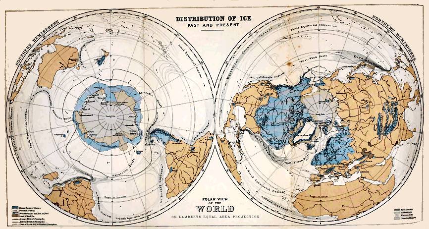
The Edinberg Geographical Institute J. G. Bartholemew, F.R.G.S.
Click on image to view larger size image.
VII.
The Intercrossing of Erratics in Glacial Deposits.[Q]
Among the many phenomena connected with the glacial deposits of this country which have puzzled geologists there is none more remarkable than the “intercrossing of erratics.” The fact that such wandered blocks have apparently crossed each other’s tracks in their journeys appears at first sight inexplicable on the assumption that their transport has been effected by land-ice. The phenomena in question, therefore, have always been appealed to by those who uphold the iceberg origin of our boulder-clays, etc., as evidence decisively in favour of their views. No one can deny that any degree and amount of intercrossing might take place in the case of icebergs. We can readily conceive how floating ice, detached from a long line of coast, might be compelled by shifting winds and changing currents to tack about again and again, so as to pursue the most devious course, and scatter their stony burdens in the most erratic manner over the sea-bottom; while, on the other hand, it is quite impossible to understand how a similar irregular distribution of erratics could take place under one and the same glacier flowing in a determinate direction. It is little wonder, then, that the curious phenomena of the intercrossing of erratics should have had much importance attached to it by the upholders of the iceberg theory, seeing that all the other proofs which have been adduced in favour of this theory have only served to demonstrate its insufficiency. Upon the facts connected with the intercrossing of erratics, the supporters of this time-honoured theory are now making what I must believe is their last stand. I purpose therefore, in this paper, to give a short outline of those facts, with the view of showing that so far from being antagonistic to the land-ice theory, they are in complete harmony with it; and indeed must be considered as affording an additional demonstration of its truth.
Some years ago I called attention to the fact that in the middle districts of Scotland the boulder-clay not infrequently contains a curious commingling of northern and southern erratics.[R] I showed that this was the case throughout a belt of country extending from the sea-coast near Ayr, north-east to the valley of the Irvine, and thence across the watershed into the Avon, and east to Lesmahagow, then down the valley of the Clyde to Carluke, stretching away to the east by Wilsontown, and thereafter continuing along the crest of the Pentlands and the northern slopes of the Lammermuir Hills, by Reston and Ayton, to the sea. “All along this line,” I remarked, “we have a ‘debatable ground’ of variable breadth, throughout which we find a commingling in the till of stones which have come from north and from south. South of it, characteristic Highland stones do not occur, and north of it stones derived from the south are similarly absent.” The explanation of these facts is obvious. The belt of ground referred to was evidently the meeting-place of the Highland and southern mers de glace. Here the two opposing ice-flows coalesced and became deflected by their mutual pressure to right and left—one great current going east and another west. It is evident that the line of junction between the two mers de glace could not be rigorously maintained in one and the same position during a period of glaciation, but would tend to oscillate backwards and forwards, according as one or the other ice-sheet prevailed. Sometimes the southern ice-sheet would be enabled to push back the northern mer de glace, while at other times the converse would take place. Nor is it necessary to suppose that the advance of one ice-sheet was general along the whole line. On the contrary, it is most likely that the movement was quite irregular—an ice-sheet advancing in some places, while at other points its line of junction with the opposing ice-sheet remained stationary, or even retrograded. Such movements would obviously give rise to oscillations in the sub-glacial débris of clay and stones; and thus we have a simple and natural explanation of those intercrossings of erratics which are so characteristic of that region which I have termed the “debatable ground.” And this conclusion is borne out by the fact that the glacial striæ of the same “debatable ground” afford like evidence of oscillation in the trend of the ice-flow.
Along the base of the Highland mountains in Forfarshire, etc., we meet with similar intercrossings of erratics. Thus we occasionally encounter in the boulder-clays overlying the Silurian regions erratics of Old Red Sandstone rocks which have come from the east or south-east; while the abundant presence of erratics of Silurian origin, on the other hand, bespeak an ice-flow from the west towards the low-grounds. In some places within the Silurian area we encounter a greyish-blue boulder-clay containing Silurian fragments only, while in other places within the same area the boulder-clay becomes reddish, and is charged with many boulders of Old Red Sandstone rocks. Now the greyish-blue till could only have been laid down by glacier-ice descending from the Silurian high-grounds to Strathmore, while the red boulder-clay points to a partial invasion of the Silurian regions by land-ice, which had previously traversed the lower-lying Old Red Sandstone areas. These apparently contradictory movements are readily accounted for by the former presence in the area of the North Sea of the great Scandinavian mer de glace. Dr. James Croll was the first to point out that the glacial phenomena of Caithness and the Shetlands could only be accounted for by the advance of the Scandinavian ice-sheet towards our coasts, where it encountered and deflected the Scottish ice-sheet out of its normal course—a sagacious induction, which the admirable and exhaustive researches of my colleagues, Messrs. B. N. Peach and J. Horne, have now firmly established. The lower blue boulder-clay was evidently accumulated at a time when the Scottish ice was able to flow more or less directly east or south-east towards what is now the coast-line; while the overlying red boulder-clay points to a subsequent period when the presence of the Scandinavian mer de glace was sufficiently great to compel the Scottish ice out of its normal course, and cause it to flow in a north-easterly direction. In doing so it now and again passed from tracts of Old Red Sandstone to invade the Silurian area, and thus an overlying red boulder-clay was here and there accumulated upon the surface of a greyish-blue till in which not a single fragment of any Old Red Sandstone rock occurs.
Recently Messrs. B. N. Peach and J. Horne, in a most instructive paper on the “Glaciation of Caithness,”[S] have described some remarkable comminglings of material which occur in a region where the glacial striæ afford equally striking evidence of conflicting ice-movements. These phenomena are developed here and there along a line which indicates the meeting-place of two rival ice-streams, on each side of which the boulder-clay presents different characteristics—the one boulder-clay being the moraine profonde of the ice that flowed ENE. and NNE. towards the Caithness plain, while the other is an accumulation formed underneath the ice that streamed across that plain from SE. to NW. These phenomena are thus, as my colleagues remark, quite analogous to those met with in the middle districts of Scotland, as described by me, and referred to in a preceding paragraph. Now it is obvious that while these examples of “intercrossings” of erratics and “cross-hatching” of striæ all go strongly to support the land-ice theory of the glacial phenomena, they at the same time negative the notion of floating-ice having had anything to do with the production of the phenomena under review.
Before considering the evidence adduced by Mr. Mackintosh and others as to the intercrossings of erratics in the drift-deposits of England, I shall mention some of the more remarkable examples of the same phenomena which have been noticed by continental geologists. The first cases I shall cite are those which have been observed in the glacial accumulations of the Rhone valley in eastern France. The land-ice origin of these accumulations has never been called in question, and as the intercrossings of erratics in that region are not only more common, but much more striking and apparently inexplicable than any which have been noticed elsewhere, it will be admitted that they of themselves afford a strong presumption that the conflicting courses followed by the erratics in certain regions of our own country are the result rather of oscillations in the flow of land-ice than of the random and eccentric action of icebergs. The researches of Swiss and French glacialists have proved that during the climax of the Glacial period an enormous area in the low-grounds of eastern France was covered with a huge mer de glace, formed by the union of the great Rhone glacier with the glaciers descending from the mountains of Savoy and Dauphiny. A line drawn from Bourg by way of Chatillon, Villeneuve, Trévoux, and Lyons to Vienne, and thence south-east by Beaurepaire to the valley of the Isère, a few miles above St. Marcellin, indicates roughly the furthest limits reached by the mer de glace. Over all the low-grounds between that terminal line and the mountains are found widespread sheets of boulder-clay and sand and gravel, together with loose erratics. Now and again, too, well-marked terminal moraines make their appearance, while the rock-surfaces, when these are visible and capable of bearing and retaining glacial markings, present the usual aspect of roches moutonnées. The same kinds of morainic materials and ice-markings may of course be followed up into the valleys not only of the Alps properly so-called, but also into those of the hills of Bugey and the secondary mountain-chain of Savoy and Dauphiny. It has indeed long been known that local glaciers formerly occupied the mountain-valleys of Bugey. For example, a number of small glaciers have descended from the slopes of the mountains west of Belley (such as Bois de la Morgue, Bois de Lind, etc.) to the Rhone, and again from Mont du Chat to the north-west. These glaciers were quite independent of the greater ice-streams of the neighbouring Alps of Savoy, and the same was the case with the glaciers of that mountainous tract which extends from Nantua south to Culoz, between the valleys of the Ain and the Rhone. From this elevated region many local glaciers descended, such as that of the Valromey, which flowed for a distance of some twenty miles from north to south. Again, similar local glaciers have left abundant traces of their former presence throughout the mountainous belt of land that stretches between Chambery and Grenoble to the west of the valley of the Isère. The moraines of all those local glaciers, charged as they are with the débris of the neighbouring heights, clearly indicate that the local glaciers flowed each down its own particular valley. There are certain other appearances, however, which seem at first sight to contradict this view. Sometimes, for example, we encounter in the same valleys erratics which do not belong to the drainage-system within which they occur, but have without doubt been derived from the higher Alps of Switzerland and Savoy. And the course followed by these foreign erratics has crossed at all angles that which the local glaciers have certainly pursued—occasionally, indeed, the one set of erratics has travelled in a direction exactly opposed to the trend taken by the others. As examples, I may cite the case of the erratics which occur in Petit Bugey. In this district we encounter many locally-derived erratics which have come from Mont du Chat to the west of the Lac du Bourget—that is to say, they have travelled in a north-westerly direction. But in the same neighbourhood are found many erratics of Alpine origin which have been carried from north-east to south-west, or at right angles to the course followed by the local erratics. Again, in the valley of the Seran we have evidence in erratics and terminal moraines of a local glacier which flowed south as far as the Lyons and Geneva Railway, in the neighbourhood of which, a few miles to the west of Culoz, its terminal moraines may be observed. This is the extinct Glacier du Valromey of MM. Falsan and Chantre. Now it is especially worthy of note that in the same valley we have distinct evidence of an ice-flow from south to north—i.e., up the valley. Erratics and morainic materials which are unquestionably of Alpine origin have been followed a long way up the Seran valley—for two-thirds of its length at least. Before they could have entered that valley and approached the slopes of Romey, they must have travelled down the valley of the Rhone from the higher Alps of Savoy in a south-west and south direction until they rounded the Montagne du Grand Colombier. It was only after they had rounded this massive mountain-ridge that they could pursue their course up the valley of the Seran, in a direction precisely opposite to that which they had previously followed. These and many similar and even more remarkable examples of the “intercrossings” of streams of erratics are described by MM. Falsan and Chantre, and graphically portrayed in their beautiful and instructive work on the “Ancient Glaciers and Erratic Deposits of the Basin of the Rhone”; and the explanation of the phenomena given by them is extremely simple and convincing. The local erratics and moraines pertain partly to the commencement and partly to the closing stage of the Glacial period. Long before the south branch of the great glacier of the Rhone had united with the glacier of the Arve, and this last with the glaciers of Annecy and Beaufurt, and before these had become confluent with the glacier of the Isère, etc., the secondary mountain-ranges of Savoy and Dauphiny and the hills of Bugey were covered with very considerable snow-fields, from which local glaciers descended all the valleys to the low-ground. But when the vast ice-flows of Switzerland, Upper Savoy, etc., at last became confluent, they completely overflowed many of the hilly districts which had formerly supported independent snow-fields and glaciers, and deposited their bottom-moraines over the morainic débris of the local glaciers. In other cases, where the secondary hill-ranges were too lofty to be completely drowned in the great mer de glace, long tongues of ice dilated into the valleys, and compelled the local ice out of its course; sometimes, as in the case of the Valromey, forcing it backward up the valleys down which it formerly flowed. But when once more the mighty mer de glace was on the wane, then the local glaciers came again into existence, and reoccupied their old courses. And thus it is that in the hilly regions at the base of the higher Alps, and even out upon the low-grounds and plains, we encounter that remarkable commingling of erratics which has been described above. Not infrequently, indeed, we find one set of moraines superposed upon another, just as in the low-grounds of northern Germany, etc., we may observe one boulder-clay overlying another, the erratics in which give evidence of transport in different directions. The observations recorded by MM. Falsan and Chantre, and their colleagues, thus demonstrate that “intercrossings” of erratics of the most pronounced character have been brought about solely by the action of glaciers. In the case of the erratics and morainic accumulations of the basin of the Rhone, the action of icebergs is entirely precluded.
I may now mention some of the more remarkable examples of intercrossings of erratics which have been recorded from the glacial accumulations of north Germany, etc. An examination of the glacial striæ, roches moutonnées, and boulder-clays of Saxony leads to the conviction, according to Credner, Penck, Torell, Helland, and others, that the whole of that region has been invaded by the great Scandinavian mer de glace which flowed into Saxony from NNE. to SSW. Erratics from southern Sweden and Gothland occur in the boulder-clay, and the presence of these, taken in connection with the direction of the glaciation, leaves us no alternative but to agree with the conclusions arrived at by the Saxon geologists. But, apparently in direct contradiction of this conclusion, we have evidence to show that boulders of the same kinds of rock occur in Denmark and Holland, pointing to a former ice-flow from north-east to south-west and west. Thus boulders derived from Gothland occur at Gröningen in Holland, while fragments from the island of Öland are met with in Faxö; and erratics from the borders of the Gulf of Finland are encountered at Hamburg. Indeed, when geologists come to examine the erratics in north Germany and Poland generally, they find evidence of apparently two ice-flows—one of which went south-south-west, south, and south-east—spreading out, as it were, in a fan-shape towards the southern limits reached by the great “Northern Drift,”—while the other seems to have followed the course of the Baltic depression, overflowing the low-grounds of northern Prussia, Holland, etc., in a south-west and west direction. Now, it is quite evident that no one mer de glace could have followed these various directions at one and the same time. The explanation of the apparent anomaly, however, is not far to seek. It is reasonable to infer that long before the mer de glace had attained its maximum dimensions, when as yet it was confined to the basin of the Baltic and was only able to overflow the northern regions of Prussia, etc., its course would be determined by the contour of the pavement upon which it advanced. It would, therefore, be compelled to follow the Baltic depression, and for a long time it would carry erratics from Finland, the Baltic islands, and eastern Sweden in a south-west and west-south-west direction. And this would continue to be the direction even after a considerable portion of the low-grounds of Prussia, etc., had been overflowed. But when the ice-sheet was enabled to advance south into Saxony, Poland, and Lithuania, erratics from Finland, the Baltic islands, etc., would necessarily cease to travel towards the west, and hold on a south-south-east, south, and south-south-west course. Again, when the mer de glace was on the decline, a time would return when the ice, as before, would be controlled in its flow by the Baltic depression, and this would give rise to a further distribution of erratics in a prevalent west-by-south direction.[T]
No one of late years has been more assiduous in the collection of facts relating to the intercrossing of erratics in the drift-deposits of England than Mr. D. Mackintosh.[U] He has written many instructive and interesting descriptions of the phenomena in question, which he justly thinks are of prime importance from a theoretical point of view. In a recent paper[V] he presents us with the results of a systematic survey of the direction and limits of dispersion of the erratics of the west of England and east of Wales, which he evidently is of opinion afford strong support to the iceberg theory, while at the same time they are directly opposed to the theory of transport by land-ice. I have attentively considered all the arguments advanced by Mr. Mackintosh in favour of his views—the one upon which he apparently lays most stress being that of the intercrossings of erratics observed by him—and I shall now proceed to point out how the phenomena described by him are most satisfactorily explained by the land-ice theory. They seem to me, indeed, to lend additional support to that theory, in the same manner as the intercrossings of boulders observed in Scotland, northern Germany, etc., and sub-alpine regions of France. Mr. Mackintosh calls attention to the fact that erratics of the well-known Criffel granite are found scattered over a large part of the plain of Cumberland, from which they extend south along the coast to near the mouth of the estuary of the Duddon. They reappear on the coast in the neighbourhood of Blackpool and Liverpool, and again at intervals on the coasts of north Wales from Flint to Colwyn Bay, and thence to Penmaenmawr and the neighbourhood of Beaumaris. They are dispersed over the peninsula of Wirral and the Cheshire plain, etc., and they have been followed south-east as far as the neighbourhood of Cardington, near Church Stretton, Burton, Wolverhampton, Stafford, Hare Castle, Macclesfield, and Manchester. This great stream of boulders, therefore, spreads out to south-east, south, and south-west: the erratics, to quote Mr. Mackintosh, “have radiated from an area much smaller than their terminal breadth.” The same is the case, I may remark in passing, with erratics in the boulder-clays of Scotland, Scandinavia, north Germany, etc., as also with those in the drift-deposits of the great Rhone glacier and other ancient glaciers both on the north and south side of the Alps. Now, the course followed by the Criffel erratics is crossed at an acute angle by the path pursued by many boulders of Eskdale granite, and various felspathic rocks derived from the Cumberland mountains. For example, Cumberland erratics of the kinds mentioned occur near St. Asaph and Moel-y-Tryfane and in Anglesey, and they have been followed over a wide district in Cheshire, etc., extending as far south as Church Stretton and Wolverhampton, and as far east as Rochdale. More than this, we find that numerous erratics of felstone, derived from the mountain of Great Arenig, in north Wales, have gone to north-east as far as Halkin Mountain, in Flintshire, Eryrys, near Llanarmon, and Chirk, from which last-named place they have been traced in a south-easterly direction to Birmingham, Bromsgrove, etc. A glance at the map of England will show that this south-easterly drift of erratics crosses at an acute angle the paths followed by the Criffel granite boulders and the erratics derived from Cumberland, so that we have now several intercrossings to account for. How can this be done by the land-ice theory?
The explanation seems to me obvious, for the phenomena are, after all, less striking than similar appearances which have been observed in Scotland, especially by my colleagues, Messrs. Peach and Horne, in Caithness and the Orkney and Shetland Islands; and they are certainly less intricate than the facts recorded by MM. Falsan and Chantre concerning the intercrossing, interosculation, and direct opposition of erratic paths in Savoy and Dauphiny. We have only to reflect that the great mer de glace—to which, as I believe, all the English phenomena are due—did not come into existence and attain its maximum dimensions in the twinkling of an eye, nor could it afterwards have disappeared in the same sudden manner. On the contrary, a period of local glaciation must have preceded the appearance of the great ice-sheet. At first, and for a long time, permanent snow would be confined to the higher elevations of the land, and glaciers would be limited to mountain-valleys; but as the temperature fell the snow-line would gradually descend, until at last, probably after a prolonged period, it reached what is now the sea-level. Thus the formation of névé and glacier-ice would eventually take place over what are now our low-grounds, and other tracts also, which are now submerged. It is quite impossible that the vast sheets of ice which can be demonstrated to have covered Scotland, a large part of England, Ireland, Scandinavia, and north Germany, and even the limited area of the Faröe Islands, could possibly have been fed by the snow-fields of mountain-heights only. The precipitation and accumulation of snow, and the formation of névé and glacier-ice, must have taken place over enormous regions in what are now the temperate latitudes of Europe.
It is obvious that the direction of ice-flow in the basin of the Irish Sea opposite the south of Scotland and the west of England, while preserving a general southerly trend, would vary at different periods. Before the mer de glace in that basin had attained its climax there must have been a time when the ice, streaming outwards from the high-grounds of Cumberland, was enabled to push its way far westward out into the basin of the Irish Sea. At that time it was still able to hold its own against the pressure exerted by the Scottish ice. But as the general mer de glace increased in thickness, the course of the Cumberland ice would be diverted ever further and further to the south-east, until, eventually, the Scottish ice came to hug the coast of Cumberland, and to overflow Lancashire in its progress towards the south-east. So gorged with ice did the basin of the Irish Sea become, that a portion of the Scottish ice was forced over the plain of Cumberland and up the valley of the Eden, where it coalesced with the ice coming north from the Shap district, and thereafter flowed in an easterly direction to join the great mer de glace of the North Sea basin.
Thus the intercrossings of the Criffel and Cumberland erratics described by Mr. Mackintosh receive a ready explanation by the land-ice theory. Nor do the intercrossings of the Welsh erratics with those derived from Scotland and Cumberland offer any difficulty. The ice coming from the Welsh mountains would naturally be deflected towards south-east by the mer de glace that streamed in that direction, and might quite well have carried its characteristic boulders as far as Birmingham before the general mer de glace had attained its greatest dimensions. But when that period of maximum glaciation arrived, the Welsh boulders would be unable to travel so far towards the east, and the Scottish and Cumberland boulders would then cross the path formerly followed by the felstone erratics from Great Arenig.
Again, it is evident that when the mer de glace was gradually decreasing similar oscillations of the ice-flow would take place, but in reverse order, and thus would give rise to a second series of intercrossings. Moreover, we must remember that the Glacial period was characterised by several great changes of climate. It was not one continuous and prolonged period of cold conditions, but consisted rather of a succession of arctic and genial climates; so that the same countries were overrun at different epochs by successive mers de glace, each of which would rework, denude, and redistribute to a large extent the morainic materials of its predecessor, and thus might well cause even greater complexity in the dispersion of erratics than has yet been recognised anywhere in these islands.
Mr. Mackintosh refers to the occurrence of chalk-flints and Lias fossils associated with northern erratics in the drift-deposits of the west of England, the presence of which, he thinks, is fatal to the theory of transport by land-ice. Thus, he says, chalk-flints, etc., have been met with at Lillieshall (east of Wellington), at Strethill (near Ironbridge), at Seisdon (between Wolverhampton and Bridgenorth), at Wolverhampton, near Stafford, and near Bushbury. Chalk-flints have also been found as far west as Malvern and Hatfield Camp, south of Ledbury. All these erratics have crossed England from the east, according to Mr. Mackintosh and other observers. Not only so, but, as Mr. Mackintosh remarks, those found at Wolverhampton, Birmingham, etc., “must have crossed the course of the northern boulders near its southerly termination.” And since both northern and eastern erratics are found associated in the same drift-deposit, it seems to him “impossible to explain the intercrossing by land-ice or glaciers.” Now, on the contrary, those eastern erratics are scattered over the very districts where I should have expected to find them. The observations of geologists in East Anglia have shown that that region has been invaded by the mer de glace of the North Sea basin.[W] This remarkable glacial invasion is proved not only by the direction followed by stones of local derivation, and by boulders which have come south from Scotland and the northern counties, but by the occurrence in the boulder-clay at Carnelian Bay and Holderness of erratics of certain well-known Norwegian rocks, which have been recognised by Mr. Amund Helland. The occurrence of chalk-flints and fragments of Oolitic rocks in the neighbourhoods mentioned by Mr. Mackintosh thus only affords additional evidence in favour of the land-ice origin of the drift-deposits described by him. The mer de glace that flowed down the east coast of England seems to have encroached more and more upon the land, until eventually it swept over the low-lying Midlands in a south-westerly direction, and coalesced with the mer de glace that streamed inland from the basin of the Irish Sea, and the ice that flowed outwards from the high-grounds of Wales. The united ice-stream would thereafter continue on its south-westerly course down the Severn valley to the Bristol Channel. I have no doubt that Mr. Mackintosh will yet chronicle the occurrence of chalk-flints and other eastern erratics from localities much further to the south than Ledbury.
Again, considerable stress has been laid by Mr. Mackintosh upon the occurrence of chalk-flints in the drift-deposits of Blackpool, Dawpool, Parkgate, Halkin Mountain, Wrexham, the peninsula of Wirral, Runcorn, Delamere, Crewe, Leylands, Piethorne (near Rochdale), and other places. “All these flints,” Mr. Mackintosh remarks, “belong to the basin of the Irish Sea, and have almost certainly crossed the general course of the northern boulders on their way from Ireland.” Here, unfortunately, the Irish Sea intervenes to conceal the evidence that is needed to enable us to track the exact path followed by the erratics in question. I am not so certain as Mr. Mackintosh that the chalk-flints he refers to came from the north of Ireland. Chalk-flints occur pretty numerously in the drift-deposits in the maritime districts of north-eastern Scotland, which we have every reason to believe have been derived from an area of Cretaceous rocks covering the bottom of the adjacent sea; and for aught one can say to the contrary, patches of chalk-with-flints may occur in like manner in the bed of the Irish Sea. I cannot at present remember whether any boulders of the basalt-rocks, which are associated with the Chalk in the north of Ireland, have been recognised in the drifts of the west of England; but if the chalk-flints really came from Antrim, it is more than probable that they would be accompanied by fragments of the hard igneous rocks which overlie the Cretaceous strata of north Ireland. Chalk and chalk-flints occur in the boulder-clay of the Isle of Man, where they are associated, Mr. Horne tells us, with Criffel granite and fragments of a dark trap-rock.[X] Possibly these last are basalt-rocks from Antrim. It seems reasonable, therefore, to believe that erratics of Irish origin have found their way to the Isle of Man; and if this be so, it may be permissible to assume that the chalk-flints of Blackpool, etc. (and perhaps also some of the basalt-rocks), have come from the same quarter. Mr. Horne has no doubt that the Irish erratics were brought to the Isle of Man by land-ice. Referring to the conclusion arrived at by Mr. Close that the Irish mer de glace “was probably not less than 3000 feet in depth,” he remarks: “It is highly probable that this great mass of Irish ice succeeded, after a hard battle (i.e., with the Scottish ice-sheet), in reaching the Manx coast-line. It is not to be supposed that the normal momentum of the respective ice-sheets remained constant. The moving force must have varied with changing conditions. On the other hand, it is quite possible that there may have been an ‘under-tow’ of the ice from the north-east coast of Ireland, which would easily account for Antrim chalk and chalk-flints in the Manx till.” I would go further, and state my conviction that before the united ice-sheets had attained their maximum development, it is almost certain that the ice flowing into the Irish Sea basin by the North Channel would for a long time exceed in mass the coalescent glaciers that descended from the Southern Uplands of Scotland, and would therefore be enabled to extend much further to the east than it could at a later date, when the general mer de glace had reached its climax. It might thus have advanced as far as and even beyond the Isle of Man. This inference is based upon the simple fact that the area drained by the mer de glace of the North Channel was very much greater than the area extending from the watershed of the Southern Uplands of Scotland to the Isle of Man. Erratics from the north of Ireland would thus travel down the bed of the North Channel, and eventually be distributed over a wide area up to and possibly even some distance beyond the Isle of Man. But as the Scottish and Cumbrian ice-flows gradually increased in importance, the mer de glace coming from the North Channel would be forced further and further to the west, until the ice-flow issuing from the high-grounds of Kirkcudbright at last succeeded in reaching the middle of the Irish Sea basin. This gradual modification of the general ice-flow in that basin would of course give rise to a redistribution of the ground-moraine, and the Irish erratics would then travel onwards underneath the Scottish ice, and eventually reach the low-grounds of Lancashire and Cheshire, along with erratics from Criffel and the Cumbrian mountains. It is, therefore, quite unnecessary to suppose that the mer de glace of the North Channel actually crossed the whole breadth of the basin of the Irish Sea to invade Lancashire, Cheshire, and north Wales. Had this been the case, chalk-flints, chalk, and many other kinds of rock derived from the north of Ireland, and even from Arran and Argyll, would have abounded in the drifts of the west of England. Erratics coming from Ireland could not possibly have travelled underneath Irish ice further east than the Isle of Man. There or thereabouts, as I have said, the mer de glace of the North Channel would begin to encounter the ice streaming down from the uplands of Galloway and the mountains of Cumberland: and as the ice from these quarters increased in thickness, it would gradually override what had formerly been the bottom-moraine or till of the North Channel mer de glace. Thus Irish erratics would become commingled with erratics from Criffel, etc., and be carried forward in a southerly and south-easterly direction. The chalk-flints in the drifts of Lancashire, Cheshire, etc., are probably therefore remaniés—the relics of the bottom-moraine of the North Channel mer de glace rearranged and redistributed. And this is why they and other Irish rocks are so comparatively rare in the glacial accumulations of the west of England.
Thus all the instances of intercrossings adduced by Mr. Mackintosh as favouring the iceberg theory, and condemning its rival, I would cite as proving exactly the opposite. So far from presenting any real difficulty to an upholder of the land-ice theory, they, in point of fact, as I have already remarked, lend that view additional support.
It is not my purpose to criticise all the arguments and reasons advanced by Mr. Mackintosh in favour of his special views, but I may be allowed a few remarks on the somewhat extraordinary character of the agents which, according to him, were mainly instrumental in producing the drift-phenomena of western England. Before doing so, however, I may point out that, in ascribing the transport of erratics in that region (and, by implication, the formation of the boulder-clays, etc., with which most of these erratics are associated) to floating-ice and sea-currents, Mr. Mackintosh has failed to furnish us with any “fossil evidence” to show that western England was under water at the time the boulder-clays and erratics were being accumulated. He speaks of cold and warm currents, but where do we find any traces of the marine organisms which must have abounded in those waters? Where are the raised sea-beaches which must have marked the retreat of the sea? Where do we encounter any organic relics that might help us to map out the zones of shallow and deep water? The sea-shells, etc., which occur in the boulder-clays are undeniably remaniés; they are erratics just as much as the rock-fragments with which they are associated. Similar assemblages of organic remains are met with in the till of Caithness, where shallow-water and deep-sea shells, and shells indicative of genial and again of cold conditions, are all confusedly distributed throughout one and the same deposit. The same or analogous facts are encountered in the Blocklehm of some parts of Prussia, marine and freshwater shells occurring commingled in the boulder-clay. Nay, even in the moraine profonde of the ancient Rhone glacier, broken and well-preserved shells of Miocene and Pliocene species appear enclosed in the tumultuous accumulation of clay, sand, and erratics. And precisely similar phenomena confront us in the glacial deposits of the neighbourhood of Lago Lugano. Mr. Mackintosh refers to the so-called “stratification” of the boulder-clay, as if that were a proof of accumulation in water. But a rude kind of bedding, generally marked by differences of colour, and sometimes by lines of stones, was the inevitable result of the sub-glacial formation of the boulder-clay. The “lines of bedding” are due to the shearing of the clay under great pressure, and may be studied in the boulder-clay of Switzerland and Italy, and in the till not only of the Lowlands but of the Highlands of Scotland. Occasionally the “lines” are so close that the clay sometimes presents the appearance of rude and often wavy and irregular lamination—a section of such a boulder-clay reminding one sometimes of that of a gnarled gneiss or crumpled schist. And these appearances may be noted in boulder-clays which occupy positions that preclude the possibility of their being marine—as in certain valleys of the Highlands, such as Strathbraan, and in the neighbourhood of Como, in Italy. This “lamination” is merely indicative of the intense pressure to which the till was subjected during its gradual accumulation under the ice. It is assuredly not the result of aqueous action. Aqueous lamination is due to sifting and winnowing—the coarser or heavier and finer or lighter particles being separated in obedience to their different specific gravity, and arranged in layers of more or less regularity according to circumstances. There is nothing of this kind of arrangement, however, in the so-called stratified boulder-clay. If the clay of an individual lamina be washed and carefully sifted, it will be found to be composed of grains of all shapes, sizes, and weights, down to the finest and most impalpable flour. It is impossible to believe that such a heterogeneous assemblage of grains could have been dropt into water without the particles being separated and sifted in their progress to the bottom. Of course, every one knows that patches and beds of laminated clay and sand of veritable aqueous origin occur now and again in boulder-clay. I suppose there is no boulder-clay without them. I have seen them in the till of Italy and Switzerland, where they show precisely the same features as the similar laminated clays in the till of our own islands. But these included patches and beds point merely to the action of sub-glacial waters, such as we know circulate under the glaciers of the Alps, of Norway, and of Greenland.
Again, I would remark that Mr. Mackintosh has ignored all the evidence which has been brought forward from time to time to demonstrate the sub-glacial origin of boulder-clay, and to prove the utter insufficiency of floating-ice to account for the phenomena. And he adduces no new facts in support of the now discredited iceberg theory, unless it be his statement that flat striated rock-surfaces (such as those near Birkenhead) have been caused by floating-ice—the dome-shaped roches moutonnées being, on the other hand the work of land-ice. As a matter of personal observation, I can assure Mr. Mackintosh that flat striated surfaces are by no means uncommonly associated in one and the same region with roches moutonnées. What are roches moutonnées but the rounded relics of what were formerly rough uneven tors, projecting bosses, and prominent rocks? The general tendency of glacial action is to reduce the asperities of a land-surface; hence projecting points are rounded off, while flat surfaces are simply, as a rule, planed smoother. Mr. Mackintosh might traverse acres of such smoothed rock-surfaces in regions where the strata are comparatively horizontal—for example, in the case of the basaltic plateaux of the Faröes and of Iceland, which have certainly been glaciated by land-ice. Similar flat glaciated surfaces are met with again and again both in the Highlands and Lowlands of Scotland, occupying positions and associated with roches moutonnées and till of such a character as to prove beyond any doubt that they no less certainly are the result of the action of land-ice. But it is needless to discuss the probability or possibility of glaciation of any kind being due to floating-ice. We know that glaciers can and do polish and striate rock-surfaces; no one, however, can say the same of icebergs: and until some one can prove to us that icebergs have performed this feat, or can furnish us with well-considered reasons for believing them to be capable of it, glacialists will continue sceptical.
But leaving these and other points which serve to show the weakness of the cause which Mr. Mackintosh supports with such keen enthusiasm, I may, in conclusion, draw attention to certain very remarkable theoretical views of his which seem to me to be not only self-contradictory, but opposed to well-known natural laws. Briefly stated, his general view is that the erratics of the west of England have been distributed by floating-ice during a period of submergence—the scattering of erratics and the accumulation of the associated glacial deposits having commenced at or about the time when the land began to sink, and continued until the submergence reached some 2000 feet below the present sea-level. In applying this hypothesis to explain the phenomena, Mr. Mackintosh makes rather free use of sea-currents and winds. For example, he holds that a current coming from Criffel carried with it boulder-laden ice which flowed south-west to the Isle of Man, south to north Wales, and south-east in the direction of Blackpool and Manchester, Liverpool and Wolverhampton, Dawpool and Church Stretton. Now, in the first place, it is very strange that there is not a vestige or trace of any such submergence, either in the neighbourhood of Criffel itself or in the region to the north of it. The whole of that region has been striated and rubbed by land-ice coming down from the watershed of the Galloway mountains, to the north of which the striæ, roches moutonnées, and tracks followed by erratics, indicate an ice-flow towards the north-west, north, and north-east. It is, therefore, absolutely certain that at the time the granite erratics are supposed to have sailed away from Criffel on floating-ice, the whole of the Southern Uplands of Scotland were covered with a great ice-field extending from Wigtown to Berwickshire; so that, according to Mr. Mackintosh’s hypothesis, we should be forced to believe that an ocean-current originated in Criffel itself! But waiving this and other insuperable objections which will occur to any geologist who is familiar with the glacial phenomena of the south of Scotland, and confining myself to the evidence supplied by the English drifts, I would remark that Mr. Mackintosh’s hypothesis is not consistent with itself. A current flowing in the direction supposed could not possibly have permitted floating-ice to sail from Cumbria to the Isle of Man, to Moel-y-Tryfane and Colwyn Bay. Mr. Mackintosh admits this himself, but infers that the transport of the Cumbrian erratics may have taken place at a different time. But how could this be, seeing that the Criffel and Cumbrian erratics occur side by side in one and the same deposit? Again, the hypothesis of an ocean-current coming from Criffel is inconsistent with the presence of the Irish chalk-flints in the drifts of the west of England. Did these also come at a different time? And what about the dispersion of erratics from Great Arenig, which have gone north-east and north-north-east, almost exactly in the face of the supposed Criffel current? Here an ocean-current is obviously out of the question; and accordingly we are told that this dispersion of Welsh boulders was probably the result of wind. But why should this wind have propelled the floating-ice so far and no further in an easterly direction? Surely if floating-ice was swept outwards from Great Arenig as far as Eryrys, bergs must have been carried now and again much further to the east. And if they did not sail eastwards, what became of them? Did they all melt away immediately when they came into the ice-laden current that flowed towards the south-east?[Y] A still greater difficulty remains. The Criffel and Cumbrian erratics suddenly cease when they are followed to the south, great quantities of them being accumulated over a belt of country extending from beyond Wolverhampton to Bridgenorth. What was it that defined the southern limits of these northern boulders? It is clear that it could not have been high-ground, for the Severn valley, not to speak of low-lying regions further to the north-east, must have been submerged according to Mr. Mackintosh’s hypothesis. There was therefore plenty of sea-room for the floating-ice to escape southwards. And yet, notwithstanding this, vast multitudes of bergs and floes, as soon as they arrived at certain points, suddenly melted away and dropt their burdens! In what region under the sun does anything like that happen at the present day? Mr. Mackintosh thinks that the more or less sharply-defined boundary-line reached by the erratics “could only have resulted from close proximity to a persistent current of water (or air?) sufficiently warm to melt the boulder-laden ice.” He does not tell us, however, where this warm current of water or air came from, or in what direction it travelled. He forgets some of his own facts connected with the appearance of erratics of eastern derivation, and which, according to him, point to an ocean-current that flowed across from Lincolnshire into the very sea in which the Criffel granite and Cumbrian boulders were being dropt. The supposed warm ocean-current, then, if such it was rather than air, could hardly have come from the east. Neither is it at all likely that it could have come from the west, sheltered as the region of the Severn valley must have been by the ice-laden mountains of Wales. Again, the south is shut to us; for there are no erratics in the south of England from which to infer a submergence of that district. If it be true that all the northern erratics which are scattered over the low-grounds of England, Denmark, Holland, Germany, Poland, and Russia, owe their origin to boulder-laden ice carried by ocean-currents, no such warm water as Mr. Mackintosh desiderates could possibly have come from the east or south-east. We are left, then, to infer that the supposed warm current[Z] must have flowed up the Severn valley directly in the face of the Criffel current, underneath which it suddenly plunged at a high temperature, the line of junction between it and the cold water being sharply defined, and retaining its position unchanged for a long period of time! However absurd this conclusion may be, it is forced upon us if we admit the hypothesis at present under review. For we must remember that the floating-ice is supposed to have melted whenever it came into contact with the warm current. The erratics occur up to a certain boundary-line, where they are concentrated in enormous numbers, and south of which they do not appear. Here, then, large and small floes alike must have vanished at once! Certainly a very extraordinary case of dissolution.
If we dismiss the notion of a warm ocean-current for that of a warm wind, we do not improve our position a whit. Where did the warm wind come from? Not, certainly, from the ice-laden seas to the east. Are we to suppose, then, that it flowed in from the south or south-west? If so, we might well ask how it came to pass that in the immediate proximity of such a very warm wind as the hypothesis demands, great snow-fields and glaciers were allowed to exist in Wales? Passing that objection, we have still to ask how this wind succeeded in melting large and small masses of floating-ice with such rapidity that it prevented any of them ever trespassing south of a certain line? It is obvious that it must have been an exceedingly hot wind; and that, just as the hypothetical warm ocean-current must have suddenly dived under the cold water coming from the north, so the hot wind, after passing over the surface of the sea until it reached a certain more or less well-defined line, must have risen all at once and flowed vertically upwards into the cold regions above.
Thus, in seeking to escape from what he doubtless considers the erroneous and extravagant views of “land-glacialists,” Mr. Mackintosh adopts a hypothesis which lands him in self-contradictions and a perfect “sea of troubles”—a kind of chaos, in fact. In attempting to explain the drifts of western England and east Wales he has ignored the conditions that must have obtained in contiguous regions—thus forgetting that “nothing in the world is single,” and that one ought not to infer physical conditions for one limited area without stopping to inquire whether these are in consonance with what is known of adjacent districts, or in harmony with the existing phenomena of nature.
I have so strongly opposed Mr. Mackintosh’s explanation of the sudden termination of the northern erratics in the neighbourhood of Wolverhampton and elsewhere, that perhaps I ought to offer an explanation of my own, that it may, in its turn, undergo examination. I labour under the disadvantage, however, of not having studied the drifts in and around Wolverhampton, etc., and the suggestion which I shall throw out must therefore be taken for what it is worth. It seems to me, then, that the concentration of boulders in the neighbourhood of Wolverhampton, and the limits reached by the northern erratics generally, mark out, in all probability, the line of junction between the mer de glace coming from the basin of the Irish Sea and that flowing across the country from the vast mer de glace that occupied the basin of the German Ocean. Along this line the southerly transport of the northern boulders would cease, and here they would therefore tend to become concentrated. But it is most likely that now and again they would get underneath the ice-flow that set down the Severn valley, and I should anticipate that they will yet be detected, along with erratics of eastern origin, as far south even as the Bristol Channel. If it be objected to this view that erratics from Great Arenig have been met with south of Wolverhampton, at Birmingham and Bromsgrove, I would reply that these erratics were probably carried south either before or after the general mer de glace had attained its climax—at a period when the Welsh ice was able to creep out further to the east than it could when the invasion of the North Sea ice was at its height.
I cannot conclude this paper without expressing my admiration for the long-continued and successful labours of the well-known geologist whose views I have been controverting. Although I have entered my protest against his iceberg hypothesis, and have freely criticised his theoretical opinions, I most willingly admit that the practical results of his unwearied devotion to the study of those interesting phenomena with which he is so familiar have laid all his fellow-workers under a debt of gratitude.
VIII.
Recent Researches in the Glacial Geology of the Continent.[AA]
THE President of this section must often have some difficulty in selecting a subject for his address. It is no longer possible to give an interesting and instructive summary of the work done by the devotees of our science during even one year. So numerous have the students of geological science become—so fertile are the fields they cultivate—so abundant the harvests they reap, that one in my present position may well despair of being able to take stock of the numerous additions to our knowledge which have accumulated within the last twelve months. Neither is there any burning question which at this time your President need feel called upon to discuss. True, there are controversies that are likely to remain unsettled for years to come—there are still not a few matters upon which we must agree to differ—we do not yet see eye to eye in all things geological. But experience has shown that as years advance truth is gradually evolved, and old controversies die out, and so doubtless it will continue to be. The day when controversies shall cease, however, is yet, I hope, far in the future; for should that dull and unhappy time ever arrive, it is quite certain that mineralogists, petrologists, palæontologists, and geologists shall have died out of the world. Following the example of many of my predecessors, I shall confine my remarks to certain questions in which I have been specially interested; and in doing so I shall endeavour to steer clear, as far as I can, of controversial matters. My purpose, then, is to give an outline of some of the results obtained during the last few years by Continental workers in the domain of glacial geology.
Those who are not geologists will probably smile when they hear one declare that wielders of the hammer are extremely conservative—that they are slow to accept novel views, and very tenacious of opinions which have once found favour in their eyes. Nevertheless, such is the case, and well for us that it is so. However captivating, however imposing, however strongly supported by evidence a new view may appear to be, we do well to criticise, to sift the evidence, and to call for more facts and experiments, if such are possible, until the proofs become so strong as to approach as near a demonstration as geologists can in most cases expect such proofs to go. The history of our science, and indeed of most sciences, affords abundant illustration of what I say. How many long years were the views of sub-aërial erosion, as taught by Hutton and Playfair, canvassed and controverted before they became accepted! And even after their general soundness had been established, how often have we heard nominal disciples of these fathers of physical geology refuse to go so far as to admit that the river-valleys of our islands have been excavated by epigene agents! If, as a rule, it takes some time for a novel view to gain acceptance, it is equally true that views which have long been held are only with difficulty discarded. Between the new and the old there is a constant struggle for existence, and if the latter should happen to survive, it is only in a modified form. I have often thought that a history of the evolution of geological theories would make a very entertaining and instructive work. We should learn from it, amongst other things, that the advance of our science has not always been continuous—now and again, indeed, it has almost seemed as if the movement had been retrograde. Knowledge has not come in like an overwhelming flood—as a broad majestic river—but rather like a gently-flowing tide, now advancing, now retiring, but ever, upon the whole, steadily gaining ground. The history I speak of would also teach us that many of the general views and hypotheses which have been from time to time abandoned as unworkable, are hardly deserving of the reproach and ridicule which we in these latter days may be inclined to cast upon them. As the Scots proverb says: “It is easy to be wise behindhand.” It could be readily shown that not a few discarded notions and opinions have frequently worked for good, and have rather stimulated than checked inquiry. Such reflections should be encouraging to every investigator, whether he be a defender of the old or an advocate of the new. Time tries all, and each worker may claim a share in the final establishment of the truth.
Perhaps there is no department of geological inquiry that has given rise to more controversy than that which I have selected for the subject of this address. Hardly a single step in advance has been taken without vehement opposition. But the din of contending sides is not so loud now—the dust of the conflict has to some extent cleared away, and the positions which have been lost or maintained, as the case may be, can be readily discerned. The glacialist who can look back over the last twenty-five years of wordy conflict has every reason to be jubilant and hopeful. Many of those who formerly opposed him have come over to his side. It is true he has not had everything his own way. Some extreme views have been abandoned in the struggle; that of a great Polar ice-sheet, for example, as conceived of by Agassiz. I am not aware, however, that many serious students of glacial geology ever adopted that view. But it was quite an excusable hypothesis, and has been abundantly suggestive. Had Agassiz lived to see the detailed work of these later days, he would doubtless have modified his notion and come to accept the view of large continental glaciers which has taken its place.
The results obtained by geologists who have been studying the peripheral areas of the drift-covered regions of our Continent, are such as to satisfy us that the drifts of those regions are not iceberg-droppings, as we used to suppose, but true morainic matter and fluvio-glacial detritus. Geologists have not jumped to this conclusion—they have only accepted it after laborious investigation of the evidence. Since Dr. Otto Torell, in 1875, first stated his belief that the Diluvium of north Germany was of glacial origin a great literature on the subject has sprung up, a perusal of which will show that with our German friends glacial geology has passed through much the same succession of controversial phases as with us. At first icebergs are appealed to as explaining everything—next we meet with sundry ingenious attempts at a compromise between floating-ice and a continuous ice-sheet. As observations multiply, however, the element of floating-ice is gradually eliminated, and all the phenomena are explained by means of land-ice and “Schmelz-wasser” alone. It is a remarkable fact that the iceberg hypothesis has always been most strenuously upheld by geologists whose labours have been largely confined to the peripheral areas of drift-covered countries. In the upland and mountainous tracts, on the other hand, that hypothesis has never been able to survive a moderate amount of accurate observation. Even in Switzerland—the land of glaciers—geologists at one time were of opinion that the boulder-clays of the low-grounds had a different origin from those which occur in the mountain-valleys. Thus, it was supposed that at the close of the Pleistocene period the Alps were surrounded by great lakes or by gulfs of some inland sea, into which the glaciers of the high valleys flowed and calved their icebergs—these latter scattering erratics and earthy débris over the drowned areas. Sartorius von Waltershausen[AB] set forth this view in an elaborate and well-illustrated paper. Unfortunately for his hypothesis no trace of the supposed great lakes or the inland sea has ever been detected: on the contrary, the character of the morainic accumulations, and the symmetrical grouping and radiation of the erratics and perched blocks over the foot-hills and low-grounds, show that these last have been invaded and overflowed by the glaciers themselves. Even the most strenuous upholders of the efficacy of icebergs as originators of some boulder-clays, admit that the boulder-clay or till, of what we may call the inner or central region of a glaciated tract is the product of land-ice. Under this category comes the boulder-clay of Norway, Sweden, and Finland, and of the Alpine Lands of central Europe, not to speak of the hilly parts of our own islands.
When we come to study the drifts of the peripheral areas, it is not difficult to see why these should be considered to have had a different origin. They present certain features which, although not absent from the glacial deposits of the inner region, are not nearly so characteristic of such upland tracts. I refer especially to the frequent interstratification of boulder-clays with well-bedded deposits of clay, sand, and gravel; and to the fact that these boulder-clays are often less compressed than those of the inner region, and have even occasionally a silt-like character. Such appearances do seem at first to be readily explained on the assumption that the deposits have been accumulated in water opposite the margin of a continental glacier or ice-sheet—and this was the view which several able investigators in Germany were for some time inclined to adopt.
But when the phenomena came to be studied in greater detail, and over a wider area, this preliminary hypothesis did not prove satisfactory. It was discovered, for example, that “giants’ kettles”[AC] were more or less commonly distributed under the glacial deposits, and such “kettles” could only have originated at the bottom of a glacier. Again, it was found that pre-glacial accumulations were plentifully developed in certain places below the drift, and were often involved with the latter in a remarkable way. The “brown-coal formation” in like manner was violently disturbed and displaced, to such a degree that frequently the boulder-clay is found to underlie it. Similar phenomena were encountered in regions where the drift overlies the Chalk—the latter presenting the appearance of having been smashed and shattered—the fragments having often been dragged some distance, so as to form a kind of friction-breccia underlying the drift, while large masses are often included in the clay itself. All the facts pointed to the conclusion that these disturbances were due to tangential thrusting or crushing, and were not the result of vertical displacements, such as are produced by normal faulting, for the disturbances in question die out from above downwards. Evidence of similar thrusting or crushing is seen in the remarkable faults and contortions that so often characterise the clays and sands that occur in the boulder-clay itself. The only agent that could produce the appearances, now briefly referred to, is land-ice, and we must therefore agree with German geologists that glacier-ice has overflowed all the drift-covered regions of the peripheral area. No evidence of marine action in the formation of the stony clays is forthcoming—not a trace of any sea-beach has been detected. And yet, if these clays had been laid down in the sea during the retreat of the ice-sheet from Germany, surely such evidence as I have indicated ought to be met with. To the best of my knowledge the only particular facts which have been appealed to, as proofs of marine action, are the appearance of bedded deposits in the boulder-clays, and the occasional occurrence in the clays themselves of a sea-shell. But other organic remains are also met with now and again in similar positions, such as mammalian bones and freshwater shells. All these, however, have been shown to be derivative in their origin—they are just as much erratics as the stones and boulders with which they are associated. The only phenomena, therefore, that the glacialist has to account for are the bedded deposits which occur so frequently in the boulder-clays of the peripheral regions, and the occasional silty and uncompressed character of the clays themselves.
The intercalated beds are, after all, not hard to explain. If we consider for a moment the geographical distribution of the boulder-clays, and their associated aqueous deposits, we shall find a clue to their origin. Speaking in general terms, the stony clays thicken out as they are followed from the mountainous and high-lying tracts to the low-grounds. Thus they are of inconsiderable thickness in Norway, the higher parts of Sweden, and in Finland, just as we find is the case in Scotland, northern England, Wales, and the hilly parts of Ireland. Traced south from the uplands of Scandinavia and Finland, they gradually thicken out as the low-grounds are approached. Thus in southern Sweden they reach a thickness of 43 metres or thereabout, and of 80 metres in the northern parts of Prussia, while over the wide low-lying regions to the south they attain a much greater thickness—reaching in Holstein, Mecklenburg, Pomerania, and west Prussia, a depth of 120 to 140 metres, and still greater depths in Hanover, Mark Brandenburg, and Saxony. In those regions, however, a considerable portion of the diluvium consists, as we shall see presently, of water-formed beds.
The geographical distribution of the aqueous deposits, which are associated with the stony clays, is somewhat similar. They are very sparingly developed in districts where the boulder-clays are thin. Thus they are either wanting, or only occur sporadically in thin irregular beds, in the high-grounds of northern Europe generally. Further south, however, they gradually acquire more importance, until in the peripheral regions of the drift-covered tracts they come to equal and eventually to surpass the boulder-clays in prominence. These latter, in fact, at last cease to appear, and the whole bulk of the diluvium, along the southern margin of the drift area, appears to consist of aqueous accumulations alone.
The explanations of these facts advanced by German geologists are quite in accordance with the views which have long been held by glacialists elsewhere, and have been tersely summed up by Dr. Jentzsch.[AD] The northern regions, he says, were the feeding-grounds of the inland-ice. In those regions melting was at a minimum, while the grinding action of the ice was most effective. Here, therefore, erosion reached its maximum—ground-moraine or boulder-clay being unable to accumulate to any thickness. Further south melting greatly increased, while ground-moraine at the same time tended to accumulate—the conjoint action of glacier-ice and sub-glacial water resulting in the complex drifts of the peripheral area. In the disposition and appearance of the aqueous deposits of the diluvium we have evidence of an extensive sub-glacial water-circulation—glacier-mills that gave rise to “giants' kettles”—chains of sub-glacial lakes in which fine clays gathered—streams and rivers that flowed in tunnels under the ice, and whose courses were paved with sand and gravel. Nowhere do German geologists find any evidence of marine action. On the contrary, the dovetailing and interosculation of boulder-clay with aqueous deposits are explained by the relation of the ice to the surface over which it flowed. Throughout the peripheral area it did not rest so continuously upon the ground as was the case in the inner region of maximum erosion. In many places it was tunnelled by rapid streams and rivers, and here and there it arched over sub-glacial lakes, so that accumulation of ground-moraine proceeded side by side with the formation of aqueous sediments. Much of that ground-moraine is of the usual tough and hard-pressed character, but here and there it is somewhat less coherent and even silt-like. Now a study of the ground-moraines of modern glaciers affords us a reasonable explanation of such differences. Dr. Brückner[AE] has shown that in many places the ground-moraine of the Alpine glaciers is included in the bottom of the ice itself. The ground-moraine, he says, frequently appears as an ice-stratum abundantly impregnated with silt and rock-fragments—it is like a conglomerate or breccia which has ice for its binding material. When this ground-moraine melts out of the ice—no running water being present—it forms a layer of unstratified silt or clay, with stones scattered irregularly through it. Such being the case in modern glaciers, we can hardly doubt that over the peripheral areas occupied by the old northern ice-sheet boulder-clay must frequently have been accumulated in the same way. Nay, when the ground-moraine melted out and dropt here and there into quietly-flowing water it might even acquire in part a bedded character.
The limits reached by the inland-ice during its greatest extension are becoming more and more clearly defined, although its southern margin will probably never be so accurately determined as that of the latest epoch of general glaciation. The reasons for this are obvious. When the inland-ice flowed south to the Harz and the hills of Saxony it formed no great terminal moraines. Doubtless many erratics and much rock-rubbish were showered upon the surface of the ice from the higher mountains of Scandinavia, but owing to the fanning-out of the ice on its southward march, such superficial débris was necessarily spread over a constantly-widening area. It may well be doubted, therefore, whether it ever reached the terminal front of the ice-sheet in sufficient bulk to form conspicuous moraines. It seems most probable that the terminal moraines of the great inland-ice would consist of low banks of boulder-clay and aqueous materials-the latter, perhaps, strongly predominating, and containing here and there larger and smaller angular erratics which had travelled on the surface of the ice. However that may be, it is certain that the whole region in question has been considerably modified by subsequent denudation, and to a large extent is now concealed under deposits belonging to later stages of the Pleistocene period. The extreme limits reached by the ice are determined rather by the occasional presence of rock-striæ and roches moutonnées, of boulder-clay and northern erratics, than by recognisable terminal moraines. The southern limits reached by the old inland-ice appear in this way to have been tolerably well ascertained over a considerable portion of central Europe. Some years ago I published a small sketch-map[AF] showing the extent of surface formerly covered by ice. On this map I did not venture to draw the southern margin of the ice-sheet in Belgium further south than Antwerp, where northern erratics were known to occur, but the more recent researches of Belgian geologists show that the ice probably flowed south for some little distance beyond Brussels.[AG] Here and there in other parts of the Continent the southern limits reached by the northern drift have also been more accurately determined, but, so far as I know, none of these later observations involves any serious modification of the sketch-map referred to.
I have now said enough, however, to show that the notion of a general ice-sheet having covered so large a part of Europe, which a few years ago was looked upon as a wild dream, has been amply justified by the labours of those who are so assiduously investigating the peripheral areas of the “great northern drift.” And perhaps I may be allowed to express my own belief that the drifts of middle and southern England, which exhibit the same complexity as the Lower Diluvium of the Continent, will eventually be generally acknowledged to have had a similar origin. I have often thought that whilst politically we are happy in having the sea all round us, geologically we should have gained perhaps by its greater distance. At all events we should have been less ready to invoke its assistance to explain every puzzling appearance presented by our glacial accumulations.
I now pass on to review some of the general results obtained by continental geologists as to the extent of area occupied by inland-ice during the last great extension of glacier-ice in Europe. It is well known that this latest ice-sheet did not overflow nearly so wide a region as that underneath which the lowest boulder-clay was accumulated. This is shown not only by the geographical distribution of the youngest boulder-clay, but by the direction of rock-striæ, the trend of erratics, and the position of well-marked terminal moraines. Gerard de Geer has given a summary[AH] of the general results obtained by himself and his fellow-workers in Sweden and Norway; and these have been supplemented by the labours of Berendt, E. Geinitz, Hauchecorne, Keilhack, Klockmann, Schröder, Wahnschaffe, and others in Germany, and by Sederholm in Finland.[AI] From them we learn that the end-moraines of the ice circle round the southern coasts of Norway, from whence they sweep south-east by east across the province of Gottland in Sweden, passing through the lower ends of Lakes Wener and Wetter, while similar moraines mark out for us the terminal front of the inland-ice in Finland—at least two parallel frontal moraines passing inland from Hango Head on the Gulf of Finland through the southern part of that province to the north of Lake Ladoga. Further north-east than this they have not been traced; but, from some observations by Helmersen, Sederholm thinks it probable that the terminal ice-front extended north-east by the north of Lake Onega to the eastern shores of the White Sea. Between Sweden and Finland lies the basin of the Baltic, which at the period in question was filled with ice, forming a great Baltic glacier which overflowed the Öland Islands, Gottland, and Öland, and which, fanning-out as it passed towards the south-west, invaded, on the south side, the Baltic provinces of Germany, while, on the north, it crossed the southern part of Scania in Sweden and the Danish islands to enter Jutland.
The upper boulder-clay of those regions is now recognised as the ground-moraine of this latest ice-sheet. In many places it is separated from the older boulder-clay by interglacial deposits—some of which are marine, while others are of freshwater and terrestrial origin. During interglacial times the sea that overflowed a considerable portion of north Germany was evidently continuous with the North Sea, as is shown not only by the geographical distribution of the interglacial marine deposits, but by their North Sea fauna. German geologists generally group all the interglacial deposits together, as if they belonged to one and the same interglacial epoch. This perhaps we must look upon as only a provisional arrangement. Certain it is that the freshwater and terrestrial beds which frequently occur on the same or a lower level, and at no great distance from the marine deposits, cannot in all cases be contemporaneous with the latter. Possibly, however, such discordances may be accounted for by oscillations in the level of the interglacial sea—land and water having alternately prevailed over the same area. Two boulder-clays, as we have seen, have been recognised over a wide region in the north of Germany. In some places, however, three or more such boulder-clays have been observed overlying one another throughout considerable areas, and these clays are described as being distinctly separate and distinguishable the one from the other.[AJ] Whether they, with their intercalated aqueous deposits, indicate great oscillations of one and the same ice-sheet—now advancing, now retreating—or whether the stony clays may not be the ground-moraines of so many different ice-sheets, separated the one from the other by true interglacial conditions, future investigations must be left to decide.
The general conclusions arrived at by those who are at present investigating the glacial accumulations of northern Europe may be summarised as follows:—
1. Before the invasion of northern Germany by the inland-ice the low-grounds bordering on the Baltic were overflowed by a sea which contained a boreal and arctic fauna. These marine conditions are indicated by the presence under the lower boulder-clay of more or less well-bedded fossiliferous deposits. On the same horizon occur also beds of sand, containing freshwater shells, and now and again mammalian remains, some of which imply cold and others temperate climatic conditions. Obviously all these deposits may pertain to one and the same period, or more properly to different stages of the same period—some dating back to a time when the climate was still temperate, while others clearly indicate the prevalence of cold conditions, and are therefore probably somewhat younger.
2. The next geological horizon in ascending order is that which is marked by the Lower Diluvium—the glacial and fluvio-glacial detritus of the great ice-sheet which flowed south to the foot of the Harz Mountains. The boulder-clay on this horizon now and again contains marine, freshwater, and terrestrial organic remains—derived undoubtedly from the so-called pre-glacial beds already referred to. These latter, it would appear, were ploughed up and largely incorporated with the old ground-moraine.
3. The interglacial beds which next succeed contain remains of a well-marked temperate fauna and flora, which point to something more than a mere partial or local retreat of the inland-ice. The geographical distribution of the beds, and the presence in these of such forms as Elephas antiquus, Cervus elephas, C. megaceros, and a flora comparable to that now existing in northern Germany, justify geologists in concluding that the interglacial epoch was one of long duration, and characterised in Germany by climatic conditions apparently not less temperate than those that now obtain. One of the phases of that interglacial epoch, as we have seen, was the overflowing of the Baltic provinces by the waters of the North Sea.
4. To this well-marked interglacial epoch succeeded another epoch of arctic conditions, when the Scandinavian inland-ice once more invaded Germany, ploughing through the interglacial deposits, and working these up in its ground-moraine. So far as I can learn, the prevalent belief among geologists in north Germany is that there was only one interglacial epoch; but, as already stated, doubt has been expressed whether all the facts can be thus accounted for. There must always be great difficulty in the correlation of widely-separated interglacial deposits, and the time does not seem to me to have yet come when we can definitely assert that all those interglacial beds belong to one and the same geological horizon.
I have dwelt upon the recent work of geologists in the peripheral areas of the drift-covered regions of northern Europe, because I think the results obtained are of great interest to glacialists in this country. And for the same reason I wish next to call attention to what has been done of late years in elucidating the glacial geology of the Alpine Lands of central Europe—and more particularly of the low-grounds that stretch out from the foot of the mountains. Any observations that tend to throw light upon the history of the complex drifts of our own peripheral areas cannot but be of service. It is quite impossible to do justice in this brief sketch to the labours of the many enthusiastic geologists who within recent years have increased our knowledge of the glaciation of the Alpine Lands. At present, however, I am not so much concerned with the proofs of general glaciation as with the evidence that goes to show how the Alpine ground-moraines have been formed, and with the facts which have led certain observers to conclude that the Alps have endured several distinct glaciations within Pleistocene times. Swiss geologists are agreed that the ground-moraines which clothe the bottoms of the great Alpine valleys, and extend outwards sometimes for many miles upon the low-grounds beyond, are of true glacial origin. Now these ground-moraines are closely similar to the boulder-clays of this country and northern Europe—like them, they are frequently tough and hard-pressed, but now and again somewhat looser, and less firmly coherent. Frequently also they contain lenticular beds, and more or less thick sheets of aqueous deposits—in some places the stony clays even exhibiting a kind of stratification—and ever and anon such water-assorted materials are commingled with stony clay in the most complex manner. These latter appearances are, however, upon the whole best developed upon the low-grounds that sweep out from the base of the Alps. The only question concerning the ground-moraines that has recently given rise to much discussion is the origin of the materials themselves. It is obvious that there are only three possible modes in which those materials could have been introduced to the ground-moraine: either they consist of superficial morainic débris which has found its way down to the bottom of the old glaciers by crevasses; or they may be made up of the rock-rubbish, shingle, gravel, etc., which doubtless strewed the valleys before these were occupied by ice; or, lastly, they may have been derived in chief measure from the underlying rocks themselves by the action of the ice that overflowed them. The investigations of Penck, Blaas, Böhm, and Brückner appear to me to have demonstrated that the ground-moraines are composed mostly of materials which have been detached from the underlying rocks by the erosive action of the glaciers themselves. Their observations show that the regions studied by them in great detail were almost completely buried under ice—so that the accumulation of superficial moraines was for the most part impossible; and they advance a number of facts which prove positively that the ground-moraines were formed and accumulated under ice. I cannot here recapitulate the evidence, but must content myself by a reference to the papers in which this is fully discussed.[AK] These geologists do not deny that some of the material may occasionally have come from above, nor do they doubt that pre-existing masses of rock-rubbish and alluvial accumulations may also have been incorporated with the ground-moraines; but the enormous extent of the latter, and the direction of transport and distribution of the erratics which they contain cannot be thus accounted for, while all the facts are readily explained by the action of the ice itself, which used its sub-glacial débris as tools with which to carry on the work of erosion.