Front matter (continued 8)
Reading edition
The succeeding period was one of eminently marine conditions, the wide distribution of Silurian strata showing that during the accumulation of these, enormous tracts of our Continent were overflowed by the sea. None of these deposits, however, is of truly oceanic origin. They appear for the most part to have been laid down in shallow seas, which here and there may have been moderately deep. During the formation of the Lower Silurian the whole of the British area, with the exception perhaps of some of the Archæan tracts of the north-west, seems to have been under water. The submergence had commenced in Cambrian times, and was continued up to the close of the Lower Silurian period. During this long-continued period of submergence volcanic activity manifested itself at various points—our country being represented at that time by groups of volcanic islands, scattered over the site of what is now Wales, and extending westward into the Irish region, and northwards into the districts of Cumberland and south Ayrshire. Towards the close of the Lower Silurian period considerable earth-movements took place, which had the effect of increasing the amount of dry land, the most continuous mass or masses of which still occupied the northern and north-western part of our Continent. In the beginning of Upper Silurian times a broad sea covered the major portion of middle and probably all southern Europe. Numerous islands, however, would seem to have existed in such regions as Wales, and the various tracts of older Palæozoic and Archæan rocks of middle Germany. Many of these islands, however, were partially and some entirely submerged before the close of Silurian times.
The next great period—that, namely, which witnessed the accumulation of the Devonian and Old Red Sandstone strata—was in some respects strongly contrasted to the preceding period. The Silurian rocks, as I have said, are eminently marine. The Old Red Sandstones, on the other hand, appear to have been accumulated chiefly in great lakes or inland seas, and they betoken therefore the former existence of extensive lands, while the contemporaneous Devonian strata are of marine origin. Towards the close of the Upper Silurian period, then, we know that considerable upheavals ensued in western and north-western Europe, and wide stretches of the Silurian sea-bottom were converted into dry land. The geographical distribution of the Devonian in Europe, and the relation of that system to the Silurian, show that the Devonian sea did not cover so broad an expanse as that of the Upper Silurian. The sea had shallowed, and the area of dry land had increased when the Devonian strata began to accumulate. In trying to realise the conditions that obtained during the formation of the Devonian and the Old Red Sandstone, we may picture to ourselves a time when the Atlantic Ocean extended eastwards over the south of England and the north-east of France, and occupied the major portion of central Europe, sweeping north-east into Russia, and how much further we cannot tell. North of that sea stretched a wide land-surface, in the hollows of which lay great lakes or inland seas, which seem now and again to have had communication with the open ocean. It was in these lakes that the Old Red Sandstone was accumulated, while the Devonian or marine rocks were formed in the wide waters lying to the south. Submarine volcanoes were active at that time in Germany; and similarly in Scotland numerous volcanoes existed, such as those of the Sidlaw Hills and the Cheviots.
The Carboniferous system contains the record of a long and complex series of geographical changes, but the chief points of importance in the present rapid review may be very briefly summed up. In the earlier part of the period marine conditions prevailed. Thus we find evidence to show that the sea extended further north than it did during the preceding Devonian period. During the formation of the mountain-limestone, a deep sea covered the major portion of Ireland and England, but shallowed off as it entered the Scottish area. A few rocky islets were all that represented Ireland and England at that time. Passing eastwards, the Carboniferous sea appears to have covered the low-grounds of middle Europe and enormous tracts in Russia. The deepest part of the sea lay over the Anglo-Hibernian and Franco-Belgian areas; towards the east it became shallower. Probably the same sea swept over all southern Europe, but many islands may have diversified its surface, as in Brittany and central France, in Spain and Portugal, and in the various areas of older Palæozoic and Archæan rocks in central and south-west Europe. In the latter stages of the Carboniferous period, the limits of the sea were much circumscribed, and wide continental conditions supervened. Enormous marshes, jungles, and forests now overspread the newly-formed lands. Another feature of the Carboniferous was the great number of volcanoes—submarine and sub-aërial—which were particularly abundant in Scotland, especially during the earlier stages of the period.
The rocks of the Permian period seem to have been deposited chiefly in closed basins. When, owing to the movement of elevation or upheaval which took place in late Carboniferous times, the carboniferous limestone sea had been drained away from extensive areas in central Europe, wide stretches of sea still covered certain considerable tracts. These, however, as time went on, were cut off from the main ocean and converted into great salt lakes. Such inland seas overspread much of the low-lying tracts of Britain and middle Germany, and they also extended over a broad space in the north-east of Russia. It was in these seas that the Permian strata were accumulated. The period, it may be added, was marked by the appearance of volcanic action in Scotland and Germany.
So far, then, as our present knowledge goes, that part of the European continent which was the earliest to be evolved lay towards the north-west and north. All through the Palæozoic era a land-surface would seem to have endured in that direction—a land-surface from the denudation or wearing down of which the marine sedimentary formations of the bordering regions were derived. But when we reflect on the great thickness and horizontal extent of those sediments, we can hardly doubt that the primeval land must have had a much wider range towards the north and north-west than is the case with modern Europe. The lands, from which the older Palæozoic marine sediments of the British Islands and Scandinavia were obtained, must, for the most part, be now submerged. In later Palæozoic times land began to extend in the Spanish peninsula, northern France, and middle Europe, the denudation of which doubtless furnished materials for the elaboration of the contemporaneous strata of those regions. Southern Europe is so largely composed of Mesozoic and Cainozoic rocks that we can say very little as to the condition of that area in Palæozoic times, but the probabilities are that it continued for the most part under marine conditions. In few words, then, we may conclude that while after Archæan times dry land prevailed in the north and north-west, marine conditions predominated further south. Ever and anon, however, the sea vanished from wide regions in central Europe, and was replaced by terrestrial and lacustrine conditions. Further, as none of the Palæozoic marine strata indicates a deep ocean, but all consist for the most part of accumulations formed at moderate depths, it follows that there must have been a general subsidence of our area to allow of their successive deposition—a subsidence, however, which was frequently interrupted by long pauses, and sometimes by movements in the opposite direction.
The first period of the Mesozoic era, namely, the Triassic, was characterised by much the same kind of conditions as obtained towards the close of Palæozoic times. A large inland sea then covered a considerable portion of England, and seems to have extended north into the south of Scotland, and across the area of the Irish Sea into the north-east of Ireland. Another inland sea extended westward from the Thüringer-Wald across the Vosges into France, and stretched northwards from the confines of Switzerland over what are now the low-grounds of Holland and northern Germany. In this ancient sea the Harz Mountains formed a rocky island. While terrestrial and lacustrine conditions thus obtained in central and northern Europe, an open sea existed in the more southerly regions of the continent. Towards the close of the period submergence ensued in the English and German areas, and the salt lakes became connected with the open sea.
During the Jurassic period the regions now occupied in Britain and Ireland by the older rocks appear to have been chiefly dry land. Scotland and Ireland, for the most part, stood above the sea-level, while nearly all England was under water—the hills of Cumberland and Westmoreland, the Pennine chain, Wales, the heights of Devon and Cornwall, and a ridge of Palæozoic rocks which underlies London, being the chief lands in south Britain. The same sea overflowed an extensive portion of what is now the Continent. The older rocks in the north-west and north-east of France, and the central plateau of the same country, formed dry land; all the rest of that country was submerged. In like manner the sea covered much of eastern Spain. In middle Europe it overflowed nearly all the low-grounds of north Germany, and extended far east into the heart of Russia. It occupied the site of the Jura Mountains, and passed eastward into Bohemia, while on the south side of the Alps it spread over a large part of Italy, extending eastward so as to submerge a broad area in Austria-Hungary and the Turkish provinces. Thus the northern latitudes of Europe continued to be the site of the chief land-masses, what are now the central and southern portions of the Continent being a great archipelago with numerous islands, large and small.
The Jurassic rocks, attaining as they do a thickness of several thousand feet, point to very considerable subsidence. The movement, however, was not continuous, but ever and anon was interrupted by pauses. Taken as a whole, the strata appear to have accumulated in a comparatively shallow sea, which, however, was sufficiently deep in places to allow of the growth, in clear water, of coral-reefs.
Towards the close of the Jurassic period a movement of elevation ensued, which caused the sea to retreat from wide areas, and thus when the Cretaceous period began the British region was chiefly dry land. Middle Europe would seem also to have participated in this upward movement. Eventually, however, subsidence again ensued. Most of what are now the low-grounds of Britain were submerged, the sea stretching eastwards over a vast region in middle Europe, as far as the slopes of the Urals. The deepest part of this sea, however, was in the west, and lay over England and northern France. Further east, in what are now Saxony and Bohemia, the waters were shallow, and gradually became silted up. In the Mediterranean basin a wide open sea existed, covering large sections of eastern Spain and southern France, overflowing the site of the Jura Mountains, drowning most of the Alpine Lands, the Italian peninsula, the eastern borders of the Adriatic, and Greece. In short, there are good grounds for believing that the Cretaceous Mediterranean was not only much broader than the present sea, but that it extended into Asia, overwhelming vast regions there, and communicated with the Indian Ocean.
Summing up what we know of the principal geographical changes that took place during the Mesozoic era, we are impressed with the fact that, all through those changes, a wide land-surface persisted in the north and north-west of the European area, just as was the case in Palæozoic times. The highest grounds were the Urals and the uplands of Scandinavia and Britain. In middle Europe the Pyrenees and the Alps were as yet inconsiderable heights, the loftiest lands being those of the Harz, the Riesen Gebirge, and other regions of Palæozoic and Archæan rocks. The lower parts of England and the great plains of central Europe were sometimes submerged in the waters of a more or less continuous sea; but ever and anon elevation ensued, and the sea was divided, as it were, into a series of great lakes. In the south of Europe a Mediterranean Sea would appear to have endured all through the Mesozoic era—a Mediterranean of considerably greater extent, however, than the present. Thus we see the main features of our Continent were already clearly outlined before the close of the Cretaceous period. The continental area then, as now, consisted of a wide belt of high-ground in the north, extending roughly from south-west to north-east; south of this a vast stretch of low-grounds, sweeping from west to east up to the foot of the Urals, and bounded on the south by an irregular zone of elevated land having approximately the same trend; still further south, the maritime tracts of the Mediterranean basin. During periods of depression the low-grounds of central Europe were invaded by the sea, and the Mediterranean at the same time extended north over many regions which are now dry land. It is in these two low-lying tracts, therefore, and the country immediately adjoining them, that the Mesozoic strata of Europe are chiefly developed.
A general movement of upheaval[DH] supervened at the close of the Cretaceous period, and the sea which, during that period, overflowed so much of middle Europe had largely disappeared before the beginning of Eocene times. The southern portions of the continent, however, were still mostly under water, while great bays and arms of the sea extended northwards now and again into central Europe. On to the close of the Miocene period, indeed, southern and south-eastern Europe consisted of a series of irregular straggling islands and peninsulas washed by the waters of a genial sea. Towards the close of early Cainozoic times, the Alps, which had hitherto been of small importance, were greatly upheaved, as were also the Pyrenees and the Carpathians. The floor of the Eocene sea in the Alpine region was ridged up for many thousands of feet, its deposits being folded, twisted, inverted, and metamorphosed. Another great elevation of the same area was effected after the Miocene period, the accumulations of that period now forming considerable mountains along the northern flanks of the Alpine chain. Notwithstanding these gigantic elevations in south-central Europe—perhaps in consequence of them—the low-lying tracts of what is now southern Europe continued to be largely submerged, and even the middle regions of the continent were now and again occupied by broad lakes which sometimes communicated with the sea. In Miocene times, for example, an arm of the Mediterranean extended up the Rhone valley, and stretched across the north of Switzerland to the basin of the Danube. After the elevation of the Miocene strata these inland stretches of sea disappeared, but the Mediterranean still overflowed wider areas in southern Europe than it does in our day. Eventually, however, in late Pliocene times, the bed of that sea experienced considerable elevation, newer Pliocene strata occurring in Sicily up to a height of 3000 feet at least. It was probably at or about that period that the Black Sea and the Sea of Asov retreated from the wide low-grounds of southern Russia, and that the inland seas and lakes of Austria-Hungary finally vanished.
The Cainozoic era is distinguished in Europe for its volcanic phenomena. The grandest eruptions were those of Oligocene times. To that date belong the basalts of Antrim, Mull, Skye, the Faröe Islands, and the older series of volcanic rocks in Iceland. These basalts speak to us of prodigious fissure eruptions, when molten rock welled up along the lines of great cracks in the earth’s crust, flooding wide regions, and building up enormous plateaux, of which we now behold the merest fragments. The ancient volcanoes of central France, those of the Eifel country and many other places in Germany, and the volcanic rocks of Hungary, are all of Cainozoic age; while, in the south of Europe, Etna, Vesuvius, and other Italian volcanoes date their origin to the later stages of the same great era.
Thus before the beginning of Pleistocene times all the main features of Europe had come into existence. Since the close of the Pliocene period there have been many great revolutions of climate; several very considerable oscillations of the sea-level have taken place, and the land has been subjected to powerful and long-continued erosion. But the greater contours of the surface which began to appear in Palæozoic times, and which in Mesozoic times were more strongly pronounced, had been fully evolved by the close of the Pliocene period. The most remarkable geographical changes which have taken place since then have been successive elevations and depressions, in consequence of which the area of our Continent has been alternately increased and diminished. At a time well within the human period our own islands have been united to themselves and the Continent, and the dry land has extended north-west and north, so as to include Spitzbergen, the Faröe Islands, and perhaps Iceland. On the other hand, our islands have been within a recent period largely submerged.
The general conclusion, then, to which we are led by a review of the greater geographical changes through which the European continent has passed is simply this—that the substructure upon which all our sedimentary strata repose is of primeval antiquity. Our dry lands are built up of rocks which have been accumulated over the surface of a great wrinkle of the earth’s crust. There have been endless movements of elevation and depression, causing minor deformations, as it were, of that wrinkle, and inducing constant changes in the distribution of land and water; but no part of the continental ridge has ever been depressed to an abysmal depth. The ridge has endured through all geological time. We can see also that the land has been evolved according to a definite plan. Certain marked features begin to appear very early in Palæozoic times, and become more and more pronounced as the ages roll on. All the countless oscillations of level, all the myriad changes in the distribution of land and water, all the earthquake disturbances and volcanic eruptions—in a word, all the complex mutations to which the geological record bears witness—have had for their end the completion of one grand design.
A study of the geological structure of Europe—an examination of the manner in which the highly folded and disturbed strata are developed—throws no small light upon the origin of the larger or dominant features of our Continent. The most highly convoluted rocks are those of Archæan and Palæozoic age, and these are developed chiefly in the north-western and western parts of the Continent. Highly contorted strata likewise appear in all the mountain-chains of central Europe—some of the rocks being of Palæozoic, while others are of Mesozoic and of Cainozoic age. Leaving these mountains for the moment out of account, we find that it is along the western and north-western sea-board where we encounter the widest regions of highly-disturbed rocks. The Highlands of Scandinavia and Britain are composed, for the most part, of highly-flexed and convoluted rocks, which speak to titanic movements of the crust; and similar much-crushed and tilted rock-masses occur in north-west France, in Portugal, and in western Spain. But when we follow the highly-folded Palæozoic strata of Scandinavia into the low-grounds of the great plains, they gradually flatten out, until in Russia they occur in undisturbed horizontal positions. Over thousands of square miles in that country the Palæozoic rocks are just as little altered and disturbed as strata pertaining to Mesozoic and Cainozoic times.
These facts can have but one meaning. Could we smooth out all the puckerings, creases, foldings, and flexures which characterise the Archæan and Palæozoic rocks of western and north-western Europe, it is certain that these strata would stretch for many miles out into the Atlantic. Obviously they have been compressed and crumpled up by some force acting upon them from the west. Now, if it be true that the basin of the Atlantic is of primeval origin, then it is obvious that the sinking down of the crust within that area would exert enormous pressure upon the borders of our continental area. As cooling and contracting of the nucleus continued, subsidence would go on under the oceanic basin, depression taking place either slowly and gradually, during protracted periods, or now and again more or less suddenly. But whether gradually or suddenly effected, the result of the subsidence would be the same upon the borders of our Continent; the strata along the whole western and north-western margins of the European ridge would necessarily be flexed and disturbed. Away to the east, however, the strata, not being subject to the like pressure, would be left in their original horizontal positions.
Now it can be shown that the mountains of Scandinavia and the British Islands are much older than the Alps, the Pyrenees, and many other conspicuous ranges in central and southern Europe. Our mountains and those of Scandinavia are the mere wrecks of their former selves. Originally they may have rivaled—they probably exceeded—the Alps in height and extent. It is most likely, indeed, that the areas of Palæozoic rocks in France, Portugal, and Spain also attained mountainous elevations. But the principal upheaval of the western margins of our Continent was practically completed before the close of the Palæozoic period, and since that time those elevated regions have been subjected to prodigious erosion, the later formations being in large measure composed of their débris. I do not, of course, wish it to be understood that there has been no upheaval affecting the west of Europe since Palæozoic times. The tilted position of many of our Mesozoic strata clearly proves the contrary. But undoubtedly the main disturbances which produced the folding, fracturing, and contortion of the Palæozoic strata of western Europe took place before the close of the Palæozoic period. The mountains of Britain and Scandinavia are amongst the oldest in Europe.
When we come to inquire into the origin of the mountains of central Europe we have little difficulty in detecting the chief factors in their formation. An examination of the Pyrenees, the Alps, and other hill-ranges having the same general trend shows us that they consist of flexed and convoluted rocks. They are, in short, mountains of elevation, ridged up by tangential thrusts. Of this we need not have the slightest doubt. If, for example, we approach the Alps from the low-grounds of France, we observe the strata as we come towards the Jura beginning to undulate—the undulations becoming more and more marked, and passing into sharp folds and plications, until, in the Alps, the beds become twisted, convoluted, and bent back upon themselves in the wildest confusion. Now, speaking in general terms, we may say that similar facts confront us in connection with every true mountain-range in central Europe. Let it be noted, further, that all those ranges have the same trend, which we may take to be approximately east and west, or nearly at right angles to the trend of the Palæozoic high-grounds of western and north-western Europe. Looked at broadly, our continental ridge may be said to be traversed from west to east by two wide depressions or troughs, separated by the intervening belt of higher grounds just referred to. The former of these troughs corresponds to the great central plain, which passes through the south of England, north-east France, the Low Countries, and Denmark, whence it sweeps east through Germany, and expands into the wide low-grounds of Russia. The southern trough or depression embraces the maritime tracts of the Mediterranean and the regions which that sea covers. Such, then, are the dominant features of our Continent, to which all others are of subordinate importance. Now it cannot be doubted that the two great troughs are belts of subsidence in the continental ridge itself. And their existence explains the origin of the mountain-ranges which separate them. We know that the northern trough is of extreme antiquity; it is older, at all events, than the Silurian period. Even at that distant date its southern limits were marked out by ridges of Archæan rocks, which seem to have formed islands in what is now middle Germany, and probably also in Switzerland and central France. The appearance of those Archæan rocks in central Europe was doubtless due to a ridging up of the crust induced by those parallel movements of subsidence which produced the northern and southern troughs. The northern trough was probably always the shallower depression of the two, for we have evidence to show that, again and again in Mesozoic and later times, the seas which overflowed what are now the central plains of Europe were of less considerable depth than that which occupied the Mediterranean trough. As time rolled on, therefore, the northern trough eventually became silted up; but so low even now is the level of that trough that a relatively slight depression would cause the sea to inundate most extensive regions in middle Europe.
In Cainozoic times, as we have seen, the last great elevation of the Alps was effected—an elevation which can hardly have been due to any other cause than the more or less abrupt depression of the earth’s crust under the Mediterranean basin. The area of that sea is now much less considerable than it was in Tertiary times—a change due in part to silting up, but chiefly perhaps to the sinking down of its bed to profounder depths.
Thus we may conclude that from a very early period—a period ante-dating the formation of our oldest fossiliferous strata—the physical structure of our Continent had already been planned. The dominant features of the primeval continental ridge are those which have endured through all geological time. They are the lines along which the beautiful lands in which we dwell have been constructed. Tilted and convoluted, broken and crushed by myriad earth-movements—scarred, furrowed, worn and degraded by the frosts, the rains, the rivers, and the seas of countless ages—the rocks of our Continent are yet eloquent of design. Where the ignorant sees nothing save confusion and discord, the thoughtful student beholds everywhere the evidence of a well-ordered evolution. Such is the conclusion to which we are led by all geological research.
SKETCH-MAPS ILLUSTRATING THE GEOGRAPHICAL EVOLUTION OF CONTINENTAL AREAS
By PROFESSOR JAMES GEIKIE, LL.D., D.C.L., F.R.S.
PLATE V
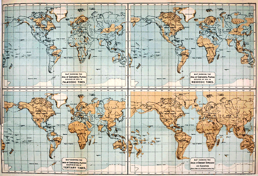
The Edinberg Geographical Institute J. G. Bartholemew, F.R.G.S.
Click on each map image to view larger sized.
XII.
The Evolution of Climate.[DI]
One of the most interesting questions with which geological science has to deal is that of the evolution of climate. Although there is no general agreement as to how former climatic fluctuations came about, yet the prevalent opinion is that in the past, just as in the present, the character of the climate must have depended mainly on latitude and the relative position of the great land- and water-areas. This was the doctrine taught by Lyell, and its cogency none will venture to dispute. It is true he postulated a total redistribution of oceans and continents—a view which the progress of science has shown to be untenable. We can no longer speculate with him on the possibility of all the great land-areas having been grouped at one time round the equator, and at some other period about the poles. On the contrary, the evidence goes to show that the continents have never changed places with the ocean—that the dominant features of the earth’s crust are of primeval antiquity, and ante-date the oldest of the fossiliferous formations. The whole question of climatic changes, therefore, must be reconsidered from the point of view of the modern doctrine of the permanency of continental and oceanic areas.
But before proceeding to this discussion, it may be well to glance for a moment at the evidence from which it has been inferred that the climate of the world has varied. Among the chief proofs of climatic fluctuations are the character and the distribution of former floras and faunas. It is true, fossils are, for the most part, relics of extinct forms, and we cannot assert of any one of these that its environment must have been the same as that of some analogous living type. But, although we can base no argument on individual extinct forms, it does not follow that we are precluded from judging of the conditions under which a whole suite of extinct organisms may have lived. Doubtless, we can only reason from the analogy of the present; but, when we take into account all the forms met with in some particular geological system, we seem justified in drawing certain conclusions as to the conditions under which they flourished. Thus, should we encounter in some great series of strata many reef-building corals, associated with large cephalopods and the remains of tree-ferns and cycads, which last from their perfect state of preservation could not have drifted far before they became buried in sediment, we should surely be entitled to conclude that the strata in question had been deposited in the waters of a genial sea, and that the neighbouring land likewise enjoyed a warm climate. Again should a certain system, characterised by the presence of some particular and well-marked flora and fauna, be encountered not only in sub-tropical and temperate latitudes but also far within the Arctic Circle, we should infer that such a flora and fauna lived under climatic conditions of a very different kind from any that now exist. The very presence, in the far north, of fossils having such a geographical distribution would show that the temperature of polar seas and lands could not have been less than temperate. When such broad methods of interpretation are applied to the problems suggested by former floras and faunas, we seem compelled to conclude that the conditions which determined the distribution of life in bygone ages must have been, upon the whole, more uniform and equable than they are now. It is unnecessary that I should go into detailed proof; but I may refer, by way of illustration, to what is known of the Silurian and Carboniferous fossils of the arctic regions. Most of these occur also in the temperate latitudes of Europe and North America, while many are recognised as distinctive types of the same strata nearly all the world over. As showing how strongly the former broad distribution of life-forms is contrasted with their present restricted range, Professor Heilprin has cited the Brachiopoda. Taking existing species and varieties as being 135 in number, he remarks that “there is scarcely a single species which can be said to be strictly cosmopolitan in its range, although not a few are very widely distributed; and, if we except boreal and hyperboreal forms, but a very limited number whose range embraces opposite sides of the same ocean. On the other hand, if we accept the data furnished by Richthofen concerning the Chinese Brachiopoda we find that out of a total of thirteen Silurian and twenty-four Devonian species, no less than ten of the former and sixteen of the latter recur in the equivalent deposits of western Europe: and, further, that the Devonian species furnish eleven, or nearly 50 per cent. of the entire number, which are cosmopolitan or nearly so. Again, of the twenty-five Carboniferous species, North America holds fully fifteen, or 60 per cent., and a very nearly equal number are cosmopolitan.” The same palæontologist reminds us that by far the greater number of fossils which occur in the Palæozoic strata of Australia are present also in regions lying well within the limits of the north temperate zone. “In fact,” he continues, “the relationship between this southern fauna and the faunas of Europe and North America is so great as to practically amount to identity.”
But, side by side with such evidence of broad distribution, we are confronted with facts which go to show that, even at the dawn of Palæozoic times, the oceanic areas at all events had their more or less distinct life-provinces. While many of the old forms were cosmopolitan, others were apparently restricted in their range. It would be strange, indeed, had it been otherwise; for, however uniform the climatic conditions may have been, still that uniformity was only comparative. An absolutely uniform world-climate is well-nigh inconceivable. All we can maintain is that the conditions during certain prolonged periods were so equable as to allow of the general diffusion of species over vastly greater areas than now; and that such conditions extended from low latitudes up to polar regions. Now, among the chief factors which in our day determine the limitation of faunas and floras, we must reckon latitude and the geographical position of land and water. What, then, it may be asked, were the causes which allowed of the much broader distribution of species in former ages?
It is obvious that before a completely satisfactory answer to that question can be given, our knowledge of past geographical conditions must be considerably increased. If we could prepare approximately correct maps and charts to indicate the position of land and sea during the formation of the several fossiliferous systems, we should be able to reason with some confidence on the subject of climate. But, unfortunately, the preparation of such correct maps and charts is impossible. The data for compilations of the kind required are still inadequate, and it may well be doubted whether, in the case of the older systems, we shall ever be able to arrive at any detailed knowledge of their geographical conditions. Nevertheless, the geological structure of the earth’s crust has been so far unravelled as to allow us to form certain general conceptions of the conditions that must have attended the evolution of our continents. And it is with such general conceptions only that I have at present to deal.
I said a little ago that the question of geological climates must now be considered from the point of view of the permanency of the great dominant features of the earth’s crust. I need not recapitulate the evidence upon which Dana and his followers have based this doctrine of the primeval antiquity of our continental and oceanic areas. It is enough if I remind you that by continental areas we simply mean certain extensive regions in which elevation has, upon the whole, been in excess of depression; by oceanic area, on the other hand, is meant that vast region throughout which depression has exceeded elevation. Thus, while the area of permanent or preponderating depression has, from earliest geological times, been occupied by the ocean, the continental areas have been again and again invaded by the sea—and even now extensive portions are under water. It is not only the continental dry land, therefore, but all the bordering belt of sea-floor which does not exceed 1000 fathoms or so in depth, that must be included in the region of dominant elevation. Were the whole of this region to be raised above the level of the sea, the present continents would become connected so as to form one vast land-mass, or continental plateau. (D, Plate IV.)
All the sedimentary strata with which we are acquainted have been accumulated over the surface of that great plateau, and consequently are of comparatively shallow-water origin. They show us, in fact, that at no time in geological history has that plateau ever been drowned in depths at all comparable to those of the deeper portions of our oceanic troughs. The stratified rocks teach us, moreover, that the present land-areas have been gradually evolved, and that, notwithstanding many oscillations of level, these areas have continued to increase in extent—so that there is probably more land-surface now than at any previous era in the history of our globe. To give even a meagre outline of the evidence bearing upon this interesting subject is here impossible. All that I can do is to indicate very briefly some of the general results to which that evidence seems to lead.
The oldest rocks with which we are acquainted are the so-called Archæan schists[DJ] But these have hitherto yielded no unequivocal traces of organic life, and as their origin is still doubtful, it would obviously be futile to speculate upon the geographical conditions of the earth’s surface at the time of their formation. Reliable geological history only begins with the fossiliferous strata of the Palæozoic era. From these we learn that in the European area the Archæan rocks of Britain, Scandinavia, and Finland formed, at that time, the most extensive tract of dry land in our part of the world. How far beyond the present limits of Europe that ancient northern land extended we cannot tell; but it probably occupied considerable regions which are now submerged in the waters of the Arctic Ocean. Further south, the continental plateau appears to have been, for the most part, overflowed by a shallow sea, the surface of which was dotted by a few islands of Archæan rocks, occupying the sites of what are now some of the hills of middle Germany and the Archæan districts of France and the Iberian Peninsula. Archæan rocks occur likewise in Corsica and Sardinia, and again in Turkey: they also form the nuclei of most of the great European mountain-chains, as the Pyrenees, the Alps, the Carpathians, and the Urals. These areas of crystalline schists may not, it is true, have existed as islands at the beginning of Palæozoic times, for they were doubtless ridged up by successive elevations at later dates; but their very presence as mountain-nuclei is sufficient to show that at a very early geological period, the continental plateau could not have been covered by any great depth of sea. We can go further than this—for all the evidence points to the conclusion that, even so far back as Cambrian times, the dominant features of the present European continent had been, as it were, sketched out. Looked at broadly, that part of the great continental plateau upon which our European lands have been gradually built up may be said to be traversed from west to east by two wide depressions, separated by an intervening elevated tract. The former of these depressions corresponds to the great Central Plain which passes through the south of England, north-east of France, and the Low Countries, whence it sweeps through Germany, to expand into the extensive low-grounds of central and northern Russia. The southern depression embraces the maritime tracts of the Mediterranean, and the regions which that sea covers. To these dominant features all the others are of subordinate importance. The two great troughs are belts of depression in the continental plateau itself. The northern one is of extreme antiquity—it is older, at all events, than the Cambro-Silurian period. Even at that distant date its southern limits were marked out by ridges of Archæan rock, which, as I have said, seem to have formed islands in what is now central Europe. It was probably always the shallower depression of the two, for we have evidence to show that again and again, in Mesozoic and later times, the sea that overflowed what are now the central lowlands of Europe was of less considerable depth than that which occupied the Mediterranean trough.
If we turn to North America, we find similar reason to conclude, with Professor Dana, that the general topography of that region had likewise been foreshadowed as far back as the beginning of the Palæozoic era. Dana tells us that even then the formation of its chief mountain-chains had been commenced, and its great intermediate basins were already defined. The oldest lands of North America were built up, as in Europe, of azoic rocks, and were grouped chiefly in the north. Archæan masses extend over an enormous region, from the shores of the Arctic Ocean down to the great lake country, and they are seen likewise in Greenland and many of the Arctic islands. They appear also in the long mountain-chains that run parallel with the coast-lines of the Continent. In a word, the present distribution of the Archæan rocks, and their relation to overlying strata, lead to the belief that in North America, just as in Europe, they form the foundation-stones of that continent, and stretch continuously throughout its whole extent.
We know comparatively little of the geology of the other great land-masses of the globe, but from such evidence as we have there is reason to believe that these in their general structure have much the same story to tell as Europe and North America. In South America, Archæan rocks extend over vast areas in the east and north-east, and reappear in the lofty mountain-chains of the Pacific border. They have been recognised also in various parts of Africa, alike in the north and east, in the interior, and in the west and south. In Asia, again, they occupy wide areas in the Indian Peninsula; they are well developed in the Himalaya, while in China and the mountains and plateaux of central Asia, azoic rocks, which are probably of Archæan age, are well developed. The crystalline schists, which cover extensive tracts in Australia and in the northern island of New Zealand, have also been referred to the same age. Thus, all the world over, Archæan rocks seem to form the surface of the ancient continental plateau upon which all other sedimentary strata have been accumulated. And in every region where Palæozoic rocks occur, we have evidence to prove that at the time these last were formed vast areas of the old continental plateau were under water.
The geological structure of the Palæozoic tracts of Europe and America has shown us that, during the protracted period of their accumulation, and notwithstanding many oscillations of level, the land-surface continued to increase. The same growth of dry land characterised Mesozoic and Cainozoic times—the primeval depressions that traverse the continental plateau became more and more silted up, and the sea eventually disappeared from extensive regions which it had overflowed in Palæozoic ages. This land-growth, of course, was not everywhere continuous. Again and again, throughout wide tracts, depression was in excess of sedimentation and elevation. Even at the present time, broad tracts of what was once dry land are submerged. But the simple fact that the younger fossiliferous strata do not extend over such wide areas as the older systems, is sufficient proof that our land-masses have all along tended to grow, and to become more and more consolidated.
Reference has already been made to the remarkable fact that no abysmal accumulations have yet been detected amongst the stratified rocks of the earth’s crust. Ordinary clastic rocks, such as shale, sandstone, and conglomerate—altered or unaltered, as the case may be—form by far the largest proportion of our aqueous strata, and speak to us only of shallow waters. It is true that some of our limestones must have accumulated in moderately deep clear seas, yet none of these limestones is of abysmal origin. They prove that portions of the continental plateau have now and again been submerged for several thousand feet, but afford no evidence of depths comparable to those of the present oceanic basins. The enormous thickness obtained by the sedimentary strata can only be explained on the supposition that deposition took place over a gradually sinking area. And thus it can be shown that, within the continental plateau, movements of depression have been carried on more or less continuously during vast periods of time—and yet so gradually, that sedimentation was able to keep pace with them. Take, for example, the Cambrian strata of Wales and Shropshire—all, apparently, shallow-water deposits—which attain a thickness of 30,000 feet, or thereabout; or the Silurian strata of the same regions, which are not much less than 20,000 feet thick; and similar great depths of sedimentary rocks might be cited from North America. Passing on to later periods, we find like evidence of long-continued depression in the thick sediments of the younger Palæozoic systems. It is noteworthy, however, that when we come down to still later ages, the movements of depression, as measured by the depths of the strata, appear to have become less and less extensive and profound. Each such movement of depression was eventually brought to a close by one or more movements of upheaval—slowly or more rapidly effected, as the case may have been. Here, then, we are confronted with the striking fact that the continental plateau has, from time to time, sunk down over wide areas to depths exceeding those of existing oceans, and yet at so slow a rate, that sedimentation prevented the depressed regions from becoming abysmal. It is obvious, then, that such areas are now dry land simply because, in the long-run, sedimentation and upheaval have been in excess of depression.
And yet, notwithstanding the numerous upheavals which have taken place over the continental plateau, these have succeeded in doing little more than drain away the sea more or less completely from the great primeval depressions by which that plateau is traversed. If it be true, therefore, that the continental plateau owes its existence to the sinking down of the earth’s crust within the oceanic basins—if the continents have been squeezed up by the tangential thrusts exerted by the sinking areas that surround them—then it follows that while lands have been gradually extending over the continental plateau, the bed of the ocean has been sinking to greater and greater depths.
If this general conclusion holds good, it is obvious that the oceanic troughs of early geological times could not have been so deep as they are now. During the Palæozoic period, the most continuous areas of dry land, as we have seen, were distributed over the northern parts of our hemisphere, while, further south, groups of islands indicated the continuation of the continental plateau. Doubtless South America, Africa, Asia, and Australia were, at that distant date, represented by similar detached areas of dry land. In a word, the primeval continental plateau was still largely under water. Judging from the character and broad distribution of the Palæozoic marine faunas the temperature of the sea was wonderfully uniform. There is certainly nothing to indicate the existence of such climatic zones as those of the present. We know very little of the terrestrial life of early Palæozoic times—the Cambro-Silurian strata are essentially marine. Land-plants, however, become more numerous in the Old Red Sandstone, and, as every one knows, they abound in the succeeding Carboniferous and Permian systems. And the testimony of these floras points to the same conclusion as that furnished by the marine faunas. The Carboniferous floras of the arctic regions, and of temperate Europe and America, not only have the same facies, but a considerable number of the species is common to both areas; while many European species occur in the Carboniferous strata of Australia and other distant lands. This common facies, and the presence of numerous cosmopolitan forms, surely indicate the former prevalence of remarkably uniform climatic conditions. The conditions, of course, need not—indeed, could not—have been absolutely uniform. At present the various climates which our globe experiences depend upon the amount of heat received directly and indirectly from the sun—oceanic and aërial currents everywhere modifying the results that are due to latitude. It cannot have been otherwise in former times. In all ages the tropics must have received more direct sun-heat than temperate and polar regions; and however much the climatic conditions of the Palæozoic era may have differed from the present—however uniformly temperature may have been distributed—still, as I have said, absolute uniformity was impossible. It was doubtless owing to the fact that the dry lands of Palæozoic times were not only much less extensive than now, but more interrupted, straggling, and insular, that the climate of the globe was so equable. Under such geographical conditions, great oceanic currents would have a much freer course than is now possible, and warm water would find its way readily across wide regions of the submerged continental plateau into the highest latitudes. The winds blowing athwart the land would everywhere be moist and warm, and no such marked differences of temperature, such as now obtain, would distinguish the arctic seas from those of much lower latitudes. At the same time, the comparatively shallow water overlying the submerged areas of the continental plateau would favour the distribution of species, and thus bring about that wide distribution of cosmopolitan forms and general similarity of facies, which are such marked features of the Palæozoic faunas. It is even quite possible that migration may have taken place here and there across the great oceanic depression itself; for it may well be doubted whether, at so early a period, the depression had sunk down to its present depth below the level of the continental plateau.
Yet, notwithstanding such facilities for migration, and the consequent similarity of facies I have referred to, the Palæozoic faunas of different regions have usually certain distinctive characters. Even at the very dawn of the era the marine faunas were already grouped into provinces, sometimes widely separated from one another, at other times closely adjacent, so that it is evident that barriers to migration here and there existed. It could hardly have been otherwise; for local and more widely-spread movements of elevation and depression took place again and again during Palæozoic times.
While the younger Palæozoic systems were being accumulated, excess of upheaval over depression resulted in the gradual increase of the land.[DK] The continental plateau came more and more to the surface, in spite of many oscillations of level. It is quite possible, nay, even probable that this persistent growth of land, and consequent modification of oceanic currents may have rendered the climatic conditions of later Palæozoic times less uniform: but, if so, such diminished uniformity has left no recognisable impress on either faunas or floras; for fossils characteristic of the Devonian and Carboniferous strata of temperate latitudes occur far within the Arctic Circle.
Descending to the Mesozoic era, we find that the character and distribution of marine faunas are still indicative of uniformity. There could have been little difference of temperature at that time between arctic seas and those of our own latitude. Cosmopolitan species abounded in the Jurassic waters, but were relatively less numerous in those of the Cretaceous period. Professor Neumayr maintains that already, in the Jurassic period, the climate had become differentiated into zones. This, he thinks, is indicated by the fact that coral reefs abound in the Jurassic strata of central Europe, while they are wanting in the contemporaneous deposits of boreal regions. Dr. Heilprin, on the other hand, is of opinion that this and certain other distinctive features of separate Jurassic life-provinces may not have been due to differences of temperature, but rather to varying physical conditions, such as character of the sea-bottom, depth of water, and so forth. Perhaps the safest conclusion we can come to, in the present state of the evidence, is that the climatic conditions of the Mesozoic era were, upon the whole, less obviously uniform than those of earlier ages, but that marked zones of climate like the present had not as yet been evolved. At the same time, when we consider how many great geographical revolutions took place during the period in question, we must be prepared to admit that these could hardly fail to influence the climate, and thus to have induced modifications in the distribution of faunas and floras. And probably evidence of such modifications will yet be recognised, if indeed the phenomena referred to by Neumayr be not a case in point. It may be noted, further, that while, according to many botanists, the plants of the Palæozoic periods bespeak not only uniform climatic conditions but the absence of marked seasonal changes, those of late Mesozoic times are indicative of less uniformity. The Cretaceous conifers, for example, show regular rings of growth, and betoken the existence of seasons, which were less marked, however, than is now the case.
The geographical changes of Mesozoic times were notable in many respects. The dominant features of Europe, already foreshadowed in early Palæozoic times, had become more clearly outlined before the close of the Cretaceous period. Notwithstanding many movements of depression, the chief land-areas continued to show themselves in the north and north-west. The highest grounds were the Urals, and the uplands of Scandinavia and Britain. In middle Europe the Pyrenees and the Alps were as yet inconsiderable heights, the loftiest lands in that region being those of the Harz, the Riesen Gebirge, and other tracts of Archæan and Palæozoic rocks. The lower parts of England and the great lowland plains of central Europe were sometimes submerged in the waters of a wide, shallow sea, but ever and anon elevation ensued, new lands appeared, and these waters became divided into a series of large inland seas and lakes. In the south, a deep Mediterranean sea would appear to have persisted all through the Mesozoic era—a sea of considerably greater extent, however, than the present.
While in Europe the dominant features of the continental plateau run approximately east and west, in North America they follow nearly the opposite direction. In early Mesozoic times, vast tracts of dry land extended across the northern and eastern sections of the latter area. Over the Rocky Mountain region, low lands and saline lakes appear to have stretched, while further west the area of the Great Plateau and the Pacific slope were covered by the sea. Towards the end of the Mesozoic era, the land in the far west became more continuous—a broad belt extending in the direction of the Pacific coast-line from Mexico up to high northern latitudes. In short, before the Cretaceous period closed, the major portion of North America had been evolved. A considerable tract of what is now the western margin of the continent, however, was still under water, while from the Gulf of Mexico (then much wider than now) a broad Mediterranean sea swept north and north-west through Texas and the Rocky Mountain region to communicate with the Arctic Ocean. All to the east of this inland sea was then, as it is now, dry land. Thus, up to the close of the Cretaceous period, in America and Europe alike, oceanic currents coming from the south had ready access across the primeval continental plateau to the higher latitudes. Southern Europe indeed, during Mesozoic times, was simply a great archipelago, having free communication on the one hand across the low-grounds of central and northern Russia with the arctic seas, and, on the other, across vast regions in Asia with the Indian Ocean.
Of the other great land-masses of the globe our knowledge is too limited to allow us to trace their geographical evolution with any confidence. But from the very wide distribution of Mesozoic strata in South America, Africa, Asia, and Australia, there can be no doubt that, at the time of their accumulation, enormous tracts in those regions were then under water. The land-masses, in short, were not so continuous and compact as they are at present. And although we must infer that considerable areas of Mesozoic land are now submerged, yet these cannot but bear a very small proportion to the wide regions which have been raised above the sea-level since Mesozoic times. In short, from what we do know of the geological structure of the continents in question, we can hardly doubt that they have passed through geographical revolutions of a like kind with those of Europe and North America. Everywhere over the great continental plateau elevation appears, in the long-run, to have been in excess of depression, so that, in spite of many subsidences, the tendency of the land throughout the world has been to extend its margins, and to become more and more consolidated. The Mesozoic lands were larger than those of the preceding Palæozoic era, but they were still penetrated in many places by the sea, and warm currents could make their way over wide tracts that are now raised above the sea-level. Under such circumstances approximately uniform conditions of climate could not but obtain.
Great geographical changes supervened upon the close of the Cretaceous period. North America then acquired nearly its present outline. Its Mediterranean sea had vanished, but the Gulf of Mexico still overflowed a considerably wider region than now, while a narrow margin of the Pacific border of the continent continued submerged. In Europe elevation ensued, and the sea which had overspread so much of the central and eastern portions of our Continent disappeared. Southern Europe, however, was still largely under water, while bays and inlets extended northwards into what are now the central regions of the Continent. On to the close of the Miocene period, indeed, the southern and south-eastern tracts of Europe were represented by straggling islands. In middle Cainozoic times the Alps, which had hitherto been of small importance, were considerably upheaved, as were also the Pyrenees and the Carpathians; and a subsequent great elevation of the Alpine area was effected after the Miocene period. Notwithstanding these gigantic movements, the low-lying tracts of what is now southern Europe continued to be largely submerged, and even the central regions of the Continent were now and again occupied by broad lakes, which sometimes communicated with the sea. After the elevation of the Miocene strata, these inland seas disappeared, but the Mediterranean still overflowed wider areas than it does to-day. Eventually, however, in late Pliocene times, the bed of that sea experienced considerable elevation; and it was probably at or about this stage that the Black Sea and the Sea of Asov retreated from the broad low-grounds of southern Russia, and that the inland seas and lakes of Austria-Hungary finally vanished.
The movements of upheaval, which caused the Cretaceous seas to disappear from such broad areas of the continental plateau, induced many changes in the floras and faunas of the globe. A notable break in the succession occurs between the Cretaceous and the Eocene, hardly one species of higher grade than the protozoa passing from one system to the other. In the Cainozoic deposits we are no longer confronted with numerous cosmopolitan species—the range of marine forms has become much more restricted. Nevertheless, the faunas and floras continue to be indicative of much warmer climates for arctic and temperate latitudes than now obtain. But, at the same time, differentiation of climate into zones is distinctly marked. In the early Cainozoic period, our present temperate latitudes supported a flora of decidedly tropical affinities, while the fauna of the adjacent seas had a similar character. Later on the climate of the same latitudes appears to have passed successively through sub-tropical and temperate stages. In short, a gradual lowering of the temperature is evinced by the character and distribution both of floras and faunas. The differentiation of the climate during one stage of the Cainozoic era is well illustrated by the Miocene flora. Thus, at a time when Italy was clothed with a tropical vegetation, in which palm-trees predominated, middle Europe had its extensive forests of evergreens and conifers, while in the region of the Baltic conifers and deciduous trees were the prevalent forms.
When one takes into consideration the fact that, notwithstanding many oscillations of level, the land during Cainozoic times was gradually extending, and the sea disappearing from wide regions which it had formerly covered, one can hardly doubt that the seemingly gradual change from tropical to temperate conditions was due, in large measure, to that persistent continental growth. I confess, however, that it is difficult to account for the very genial climate which continued to prevail over the arctic regions. So far as one can gather from the evidence at present available, some of the marine approaches to those latitudes had been cut off by the movements of elevation which brought the Cainozoic era to a close, while the arctic lands were perhaps more extensive than they are now. The Cretaceous Mediterranean Sea of North America had vanished, and we cannot prove that the Tertiary Sea of southern Europe communicated across the low-grounds of Russia with the Arctic Ocean. We know, however, that the archipelago of southern Europe was in direct connection with the Indian Ocean, and it is most probable that a wide arm of the same sea stretched north from the Aralo-Caspain area through Siberia. Indeed, much of what are now the lowlands of western and northern Asia was probably sea in Tertiary times. It seems likely, therefore, that, even at this late period, marine currents continued to reach the Arctic Zone across the continental plateau. When the warm waters of the Indian Ocean eventually ceased to invade Europe, and the Mediterranean became much restricted in area, the climate of the whole Continent could not fail to be profoundly affected.
There is yet another line of evidence to which brief reference may be made. I have spoken of the remarkable uniformity of climatic conditions which obtained in Palæozoic times, and of the gradual modification of these conditions which subsequently supervened. Now, it is worthy of note that in their lithological characters the oldest sedimentary strata themselves likewise exhibit a prevalent uniformity which in later systems becomes less and less conspicuous. The Cambro-Silurian mechanical sediments, for example, maintain much the same character all the world over; and the like is true, although in a less degree, of the marine accumulations of the Devonian period. The corresponding mechanical deposits of later Palæozoic ages continue to show more and more diversity, but at the same time they preserve a similarity of character over much more extensive areas than is found to be the case with the analogous sediments of the Mesozoic era. Finally, these last are more or less strongly contrasted with the marine mechanical accumulations of Cainozoic times, which are altogether more local in character. This increasing differentiation is quite in keeping with what we know of the evolution of our land-areas. In early Palæozoic ages, when insular conditions prevailed and the major portion of the primeval continental plateau was covered by shallow seas, it is obvious that mechanical sediments would be swept by tidal and other currents over enormous areas, and that these sediments would necessarily assume a more or less uniform character. Indeed, I suspect that much of the sediment of those early seas may have been the result of tidal scour, and that marine erosion was more generally effective then than it is now. With the gradual growth of the land and the consequent deflection and limitation of currents, marine mechanical sediments would tend to become more and more local in character. Thus the increasing differentiation which we observe in passing from the earlier to the later geological systems is just what might have been expected.
Summing up, now, the results of this rapid review of the evidence, we seem justified in coming to the following conclusions:—
(1.) In Palæozoic times, Europe and North America were represented by considerable areas of dry land, massed chiefly in the higher latitudes, while further south groups of smaller islands were scattered over the submerged surface of the primeval continental plateau. The other continents appear, in like manner, to have been represented by islands—some of which may have reached continental dimensions. A very remarkable uniformity of climate accompanied these peculiar geographical conditions.
(2.) In Mesozoic times, the primeval continental plateau came more and more to the surface, but the land-areas were still much interrupted, so that currents from tropical regions continued to have ready access to high latitudes. The climate of the whole globe, therefore, was still uniform, but apparently not so markedly as in the preceding era.
(3.) In Cainozoic times, the land-masses continued to extend, and the sea to retreat from hitherto submerged areas of the continental plateau; and this persistent land-growth was accompanied by a gradual lowering of the temperature of northern and temperate latitudes, and a more and more marked differentiation of climate into zones.
Having thus very briefly sketched the geographical evolution of the land during Palæozoic, Mesozoic, and Tertiary times, and come to the general conclusion that climate has varied according to the relative position of land and sea, I have next to consider the geographical and climatic conditions of the Quaternary period. These, however, are now so well known, that I need to no more than remind you that, so far as the chief features of our lands are considered, all these had come into existence before the dawn of the Ice Age. The greater contours of the surface, which were foreshadowed in Palæozoic times, and which in Mesozoic times were more clearly indicated, had been fully evolved by the close of the Pliocene period. The connection between the Mediterranean and the Indian Ocean probably ceased in late Pliocene times. The most remarkable geographical changes which have taken place since then within European regions have been successive elevations and depressions, in consequence of which the area of our Continent has been alternately increased and diminished. At a time well within the human period, our own islands have been united to themselves and the Continent, and the dry land has extended north-west and north, so as to include Spitzbergen, the Faröe Islands, and perhaps Iceland. On the other hand, our islands have been within a recent period largely submerged. Similarly, in North America, we are furnished with many proofs of like oscillations of level having taken place in Quaternary times. Is it possible, then, to explain the climatic vicissitudes of the Pleistocene period by means of such oscillations? Many geologists have tried to do so, but all these attempts have failed. It is quite true that a general elevation of the land in high latitudes would greatly increase the ice-fields of arctic regions, and might even give rise to perennial snow and glaciers in the mountain-districts of our islands. But it is inconceivable that any such geographical change could have brought about that general lowering of temperature over the whole northern hemisphere which took place in Pleistocene times. For we have to account not only for the excessive glaciation of northern and north-western Europe, and of the northern parts of North America, but for the appearance of snow-fields and glaciers in much more southern latitudes, and in many parts of Asia where no perennial snow now exists. Moreover, we have to remember that arctic conditions of climate obtained in north-western Europe even when the land was relatively much lower than it is at present. The arctic shell-beds of our own and other temperate regions sufficiently prove that geographical conditions were not the only factor concerned in bringing about the peculiar climate of the Pleistocene period. Then, again, we must not forget that at certain stages of the same period genial conditions of climate were coincident with a much wider land-surface in north-western Europe than now exists. The very fact that interglacial deposits occur in every glaciated region is enough of itself to show that the arctic conditions of the Pleistocene could not have resulted entirely from a mere elevation of land in the northern parts of our hemisphere.
The only explanation of the peculiar climatic vicissitudes in question which seems to meet the facts, so far as these have been ascertained, is the well-known theory advanced by Dr. Croll. After carefully considering all the objections which have been urged against that theory, there is only one, as it seems to me, that is deserving of serious attention. This objection is not based on any facts connected with the Pleistocene deposits themselves, but on evidence of quite another kind. It is admitted that were the Pleistocene deposits alone considered, Croll’s theory would fully account for the phenomena. But, it is argued, we cannot take the Pleistocene by itself, for if that theory be true, then climatic conditions similar to those of the Pleistocene must have supervened again and again during the past. Where, then, we are asked, is there any evidence in Palæozoic, Mesozoic, or Cainozoic strata of former widespread glacial conditions? If continental ice-sheets, comparable to those of the Pleistocene, ever existed in the earlier ages, surely we ought to find more or less unmistakable traces of them. Now, at first sight, this looks a very plausible objection, but it has always seemed to me to be based upon an assumption that is not warranted by our knowledge of geographical evolution. Dr. Croll always admitted implicitly that high eccentricity of the earth’s orbit might have happened again and again without inducing glacial conditions like those of the Pleistocene. The objection takes no account of the fact that the excessive climate of the Glacial period was only possible because of special geographical conditions—conditions that do not appear to have been fully evolved before Pliocene times. No one has seen this more clearly than Mr. Wallace,[DL] with the general drift of whose argument I am quite at one. In earlier ages, the warm water of the tropics overflowed wide areas of our present continents—most of the dry land was more or less insular, and the seas within the Arctic Circle were certainly not cold as at present, but temperate and even genial. If we go back to Cambro-Silurian times, we find only the nuclei, as it were, of our existing continents appearing above the surface of widespread shallow seas. It is quite impossible, therefore, that under such geographical conditions, great continuous ice-sheets, like those of the Pleistocene, could have existed—no matter how high the eccentricity of the earth’s orbit may have been. The most that could have happened during such a period of eccentricity would be the accumulation of snow-fields on mountains and plateaux of sufficient height, the formation here and there of local glaciers, and the descent of these in some places to the sea. And what evidence of such local glaciation might we now expect to find? No old land-surface of that far-distant period has come down to us: we look in vain for Cambro-Silurian roches moutonnées and boulder-clay or moraines. The only evidence we could expect is just that which actually occurs, namely, erratics (some of them measuring five feet and more in diameter) embedded in marine deposits. It may be said that a few erratics are hardly sufficient to prove that a true Glacial period supervened in Cambro-Silurian times, and I do not insist that they are. But I certainly maintain that if any lowering of the temperature were induced by high eccentricity of the earth’s orbit during Cambro-Silurian times, then ice-floated erratics are the only evidence of refrigeration that we need ever hope to find. The geographical conditions of early Palæozoic times forbade the formation of enormous ice-sheets like those of the Pleistocene period. Extreme climatic changes were then impossible, and periods of high eccentricity might have come and gone without inducing any modifications of flora and fauna which we could now recognise. We are ignorant of the terrestrial life of the globe at that distant period, and our knowledge of the marine fauna is not sufficient to enable us to deny the possibility of moderate fluctuations in the temperature of the seas of early Palæozoic times. Moreover, we must not forget there were then no such barriers to migration as now exist. If the conditions became temporarily unsuitable, marine organisms were free to migrate into more genial waters, and to return to their former habitats when the unfavourable conditions had passed away.
The uniform climate so characteristic of the Cambro-Silurian period appears to have prevailed likewise during the later stages of the Palæozoic era. This we gather from a general consideration of the floras and faunas, and their geographical distribution. The dry land, as we have seen, continued to increase in extent; but vast areas of the primeval continental plateau of the globe still continued under water, and currents from southern latitudes flowed unrestricted into polar regions. During the protracted lapse of time required for the formation of the later Palæozoic systems several periods of high eccentricity must have occurred. But, so far as one can judge, the disposition of the larger land-areas was never such as to induce a true Ice Age. Nevertheless we are not without evidence of ice-action in Old Red Sandstone, Carboniferous, and Permian strata. And it seems to me probable that the erratic accumulations referred to may really indicate local action, of more or less intensity, brought about by such lowering of the temperature as would supervene during a period of high eccentricity. It is true we may explain the phenomena by inferring the existence of mountains of sufficient elevation—and this, indeed, is the usual explanation. But it is doubtful whether those who adopt that view have fully considered what it involves. Take, for example, the case of the breccias and conglomerates of the Lammermuir Hills, which have all the appearance of being glacial and fluvio-glacial detritus. These deposits overlie the highly-denuded Silurian greywackés of Haddingtonshire in the north and of Berwickshire in the south, and have evidently been derived from the intervening high-grounds—the width of which between the Old Red Sandstone accumulations in question does not exceed eight or nine miles. The breccias reach a height of 1300 feet, while the dominating point of the intervening uplands is 1700 feet. Under present geographical conditions it is doubtful whether perennial snow and glaciers of any size at all could exist in the region of the Lammermuirs at a less altitude than 7000 feet or more. But between the breccias of Haddingtonshire and the equivalent deposits in Berwickshire there is no space for any intermediate range of mountains of circumdenudation of such a height. Moreover, we must remember that under the extremely uniform conditions which obtained in Palæozoic times the snow-line could not possibly have been attained even at that elevation. When the Devonian coral-reefs described by Dupont were growing in the sea that overflowed western Europe, to what height must the southern uplands of Scotland have been elevated in order to reach the snow-line! We may make what allowance we choose for the denudation which the Silurian rocks of the Lammermuirs must have experienced since the deposition of the Old Red Sandstone, but it is simply a physical impossibility that mountains of circumdenudation of the desiderated height could ever have existed in the Lammermuir region at the time the coarse breccias were being accumulated.[DM] It seems to me, then, that these breccias are in every way better accounted for by a lowering of temperature due to increased eccentricity of the orbit. This view frees us from the necessity of postulating excessive upheavals over very restricted areas, and of creating Alps where no Alps could have existed.
When we consider the enormous thickness of the strata that constitute any of our larger coal-fields, we can hardly doubt that one or more periods of high eccentricity must have occurred during their accumulation. It does not follow, however, that we should be able to detect in these strata any evidence of alternating cold and warm epochs. So long as ocean-currents from the tropics found ready entrance to polar regions across vast tracts of what is now dry land, extreme and widespread glacial conditions were impossible. Any lowering of temperature due to cosmical causes might indeed induce new snow-fields and glaciers to appear, or existing ones to extend themselves in northern regions and the most elevated lands of lower latitudes; but such local glaciation need not have seriously affected any of the areas in which coal-seams were being formed. For nothing appears more certain than this—that our coal-seams as a rule were formed over broad, low-lying alluvial lands, and in swamps and marshes, along the margins of estuaries or shallow bays of the sea. Some seams, it is true, are evidently formed of drifted vegetable débris, but the majority point to growth in situ. The strata with which they are associated are shallow-water sediments which could only have been deposited at some considerable distance from any mountain-regions in which glaciers were likely to exist. It is idle, therefore, to ask for evidence of glacial action amongst strata formed under such conditions. The only evidence of ice-work we are likely to get is that of erratics. And these are not wanting, although it is probable that most of those which are found embedded in coals have been transported by rafts of vegetable matter or in the roots of trees. The same explanation, however, will not account for the boulders which Sir William Dawson has recorded from the coal-fields of Nova Scotia. He describes them as occurring on the outside of a gigantic esker of Carboniferous age, and thinks they were probably dropped there by floating-ice at a time when coal-plants were flourishing in the swamps on the other side of the gravel embankment.
If the disposition of the land-areas in Carboniferous times rendered such an ice-age as that of the Pleistocene impossible—in other words, if the effects flowing from high eccentricity of the orbit must to a large extent have been neutralised—the flora and fauna of the period can hardly be expected to yield any recognisable evidence of fluctuating climatic conditions. When our winter happened in aphelion new snow-fields might have appeared, or already existing glaciers might have increased in size; while, with the winter in perihelion, the temperature in northern latitudes would doubtless be raised. But the general result would simply be an alternation of warm and somewhat cooler conditions. And such fluctuations of climate might readily have taken place without materially modifying; the life of the period.
The breccias of the Permian system have been described by Ramsay as of glacial origin. Some geologists agree with him, while others do not—and many have been the ingenious suggestions which these last have advanced in explanation of the phenomena. Some have tried to show how the stones and blocks in the breccias may have been striated without having recourse to the agency of glacier-ice, but they cannot explain away the fact that many of the stones (which vary in size from a few inches to three or four feet in diameter) have travelled distances of thirty or forty miles from the parent rocks. Similar erratic accumulations, which may belong to the same system or to the Carboniferous, occur in India and Australia. According to Dr. Blanford, the Indian boulder-beds are clearly indicative of ice-action, and he does not think that they can be explained by an assumed former elevation of the Himalaya. On the contrary, he is of opinion that the facts are best accounted for by a general lowering of the temperature, due probably to the action of cosmical causes. Daintree, Wilkinson, R. Oldham, and others who have studied the Australian erratic beds have likewise stated their belief that these are of true glacial origin.
I may pass rapidly over the Mesozoic systems, taking note, however, of the fact that in them we encounter evidence of ice-action of much the same kind as that met with in Palæozoic strata. While, on the one hand, the Mesozoic floras and faunas bespeak climatic conditions similar to those of earlier ages, but probably not quite so uniform; on the other, the occurrence of erratics in various marine accumulations is sufficient to show that now and again ice floated across seas, the floors of which were tenanted by reef-building corals. The geographical conditions continued unfavourable to the formation of extensive ice-sheets in temperate latitudes, no matter how high the eccentricity of the orbit might have been. The erratics which occur in certain Jurassic and Cretaceous deposits are admitted by most geologists to have been ice-borne. Now, it is highly improbable that the transporting agent could have been coast-ice, for it is hardly possible to conceive of ice forming on the surface of a sea in which flourished an abundant Mesozoic fauna. The erratics, therefore, seem to imply the existence in Mesozoic times of local glaciers, which here and there descended to the sea, as in the north-east of Scotland. The erratics in the Scottish Jurassic are evidently of native origin, and it is most improbable that those which have been met with in the Chalk of England and France could have floated from any very great distance. How, then, can we explain the appearance of local glaciers in these latitudes during Mesozoic times? The geographical conditions of the period could not have favoured the formation of perennial snow and ice in our area, unless our lands were at that time much more elevated than now. And this is the usual explanation. It is supposed that mountains much higher than any we now possess probably existed in such regions as the Scottish Highlands. It is easy to imagine the former existence of such mountains. So long a time has elapsed since the Jurassic period, that the Archæan and Palæozoic areas cannot but have suffered prodigious denudation in the interval. But, when one considers how very lofty, indeed, those mountains must have been, in order to reach the snow-line of Jurassic times, one may be excused for expressing a doubt as to whether the suggested explanation is reasonable. At all events, the phenomena are, to say the least, as readily explicable on the supposition that the snow-line was temporarily lowered by cosmical causes. Even with eccentricity at a high value, no great ice-sheets, indeed, could have existed, but local snow-fields and glaciers might have appeared in such mountain-regions as were of sufficient height. And this might have happened without producing any great difference in the temperature of the sea, or any marked modification in the distribution of life. In short, we should simply have, as before, an alternation of warm and somewhat cooler climates, but nothing approaching to the glacial and interglacial epochs of the Pleistocene.
These conclusions seem to me to be strongly supported by the evidence of ice-action during Tertiary times. The gigantic erratics of the Alpine Eocene do not appear to have been derived from the Alps, but rather from the Archæan area of southern Bohemia. The strata in which they occur are, for the most part, unfossiliferous; they contain only fucoidal remains, and are presumably marine. How is it possible to account for the appearance of these erratics in marine deposits in central Europe at a time when, as evidenced by the Eocene flora and fauna the climate was warm? Are we to infer the former existence of an extremely lofty range of Bohemian Alps which has since vanished? Is it not more probable that here, too, we have evidence of a lowering of the snow-line, induced by cosmical causes, which brought about the appearance of snow-fields and glaciers in a mountain-tract of much less elevation than would have been required in the absence of high eccentricity of the orbit? If it be objected that such cosmical causes must have had some effect upon the distribution of life, I reply that very probably they had, although not to any extreme extent. The researches of Mr. Starkie Gardner have shown that the flora of the English Eocene affords distinct evidence of climatic changes. But as the geographical conditions of that period precluded the possibility of extensive glaciation, and could only, at the most, have induced local glaciers to appear in elevated mountain-regions, it seems idle to cite the non-occurrence of erratics and morainic accumulations in the Eocene of England and France as an argument against the application of Croll’s theory to the case of the erratics of the Flysch. I repeat, then, that under the geographical conditions of the Eocene, all the more obvious effects likely to have resulted from the passage of a period of high eccentricity would be the appearance of a few local glaciers, the existence of which could have had no more influence on the climate of adjacent lowlands than is notable in similar circumstances in our own day. It is absurd, therefore, to expect to find evidence in Eocene strata of as strongly contrasted climates as those of the glacial and interglacial deposits of the Pleistocene. There must, doubtless, have been alternations of climate in our hemisphere; but these would consist simply of passages from warm to somewhat cooler conditions—just such changes, in fact, as are suggested by the plants of the English Eocene.
The evidence of ice-action in the Miocene strata is even more striking than that of which I have just been speaking. The often-cited case of the erratics of the Superga near Turin I need do little more than mention. These erratics were undoubtedly carried by icebergs, calved from Alpine glaciers at a time when northern Italy was largely submerged. The erratic deposits are unfossiliferous, and are underlaid and overlaid by fossiliferous strata, in none of which are any erratics to be found. What is the meaning of these intercalated glacial accumulations? Can we believe it possible that the Miocene glaciers were enabled to reach the sea in consequence of a sudden movement of elevation, which must have been confined to the Alps themselves? Then, if this be so, we must go a step further, and suppose that, after some little time, the Alps were again suddenly depressed, so that the glaciers at once ceased to reach the sea-coast. For, as Dr. Croll has remarked, “had the lowering of the Alps been effected by the slow process of denudation, it must have taken a long course of ages to have lowered them to the extent of bringing the glacial state to a close.” And we should, in such a case, find a succession of beds indicating a more or less protracted continuance of glacial conditions, and not one set of erratic accumulations intercalated amongst strata, the organic remains in which are clearly suggestive of a warm climate. The occurrence of erratics in the Miocene of Italy is all the more interesting from the fact that in the Miocene of France and Spain similar evidence of ice-action is forthcoming.
Opponents of Dr. Croll’s theory have made much of Baron Nordenskiöld’s statement that he could find no trace of former glacial action in any of the fossiliferous formations within the Arctic regions. He is convinced that “an examination of the geognostic condition, and an investigation of the fossil flora and fauna of the polar lands, show no signs of a glacial era having existed in those parts before the termination of the Miocene period.” Well, as we have seen, there is no reason to believe that the geographical conditions in our hemisphere, at any time previous to the close of the Pliocene period, could have induced glacial conditions comparable to those of the Pleistocene Ice Age. The strata referred to by Nordenskiöld, are, for the most part, of marine origin, and their faunas are sufficient to show us that the Arctic seas were formerly temperate and genial. If any ice existed then, it could only have been in the form of glaciers on elevated lands. And it is quite possible that these, during periods of high eccentricity, may have descended to the sea and calved their icebergs; and, if so, erratics may yet be found embedded here and there in the Arctic fossiliferous formations, although Nordenskiöld failed to see them. One might sail all round the Palæozoic coast-lines of Scotland without being able to observe erratics in the strata, and yet, as we know, these have been encountered in the interior of the country. The wholesale scattering of erratics at any time previous to the Pleistocene, must have been exceptional even in arctic regions, and consequently one is not surprised that they do not everywhere stare the observer in the face.
The general conclusion, then, to which I think we may reasonably come, is simply this:—That geological climate has been determined chiefly by geographical conditions. So long as the lands of the globe were discontinuous and of relatively small extent, warm ocean-currents reaching polar regions produced a general uniformity of temperature—the climate of the terrestrial areas being more or less markedly insular in character. Under these conditions, the sea would nowhere be frozen. But when the land-masses became more and more consolidated, when owing to the growth of the continents the warm ocean-currents found less ready access to arctic regions, then the temperature of those regions was gradually lowered, until eventually the seas became frost-bound, and the lands were covered with snow and ice. But while the chief determining cause of climate has been the relative distribution of land and water, it is impossible to doubt that during periods of high eccentricity of the orbit, the climate must have been modified to a greater or less extent. In our own day the geographical conditions are such that, were eccentricity to attain a high value, the climate of the Pleistocene would be reproduced, and our hemisphere would experience a succession of alternating cold and genial epochs.
But in earlier stages of the world’s history, the geographical conditions were not of a kind to favour the accumulation of vast ice-fields. During a period of extreme eccentricity, there would probably be fluctuations of temperature in high latitudes; but nothing like the glacial and interglacial epochs of the Pleistocene could have occurred. At most, there would be a general lowering of the temperature, sufficient to render the climate of arctic seas and lands somewhat cooler, and probably to induce the appearance in suitable places of local glaciers; and, owing to precession of the equinox, these cooler conditions would be followed by a general elevation of the temperature above the normal for the geographical conditions of the period. In Palæozoic and Mesozoic times, the effects of high eccentricity of the orbit appear to have been, in a great measure, neutralised by the geographical conditions, with a possible exception in the Permian period. But in Tertiary times, when the land-masses had become more continuous, the cosmical causes of change referred to must have had greater influence. And I cannot help agreeing with Dr. Croll that the warm climates of the Arctic regions during that era were, to some extent, the result of high eccentricity.
In concluding this discussion, I readily admit that our knowledge of geographical evolution is as yet in its infancy. We have still very much to learn, and no one will venture to dogmatise upon the subject. But I hope I have made it clear that the evidence, so far as it goes, does not justify the confident assertions of Dr. Croll’s opponents, that his theory is contradicted by what we know of the climatic conditions of Palæozoic, Mesozoic, and Cainozoic times. On the contrary, it seems to me to gain additional support from the very evidence to which Nordenskiöld and others have appealed.
Note.—The accompanying sketch-maps (Plate IV.) require a few words of explanation. The geology of the world is still so imperfectly known that any attempt at graphic representation of former geographical conditions cannot but be unsatisfactory. The approximate positions of the chief areas of predominant elevation and depression during stated periods of the past may have been ascertained in a general way; but when we try to indicate these upon a map, such provisional reconstructions are apt to suggest a more precise and definite knowledge than is at present attainable. For it must be confessed that there is hardly a line upon the small maps (A, B, C) which might not have been drawn differently. This, of course, is more especially true of South America, Africa, Asia—of large areas of which the geological structure is unknown. But although the boundaries of the land-masses shown upon the maps referred to are thus confessedly provisional, the maps nevertheless bring out the main fact of a gradual growth and consolidation of the land-areas—a passage from insular to continental conditions. I need hardly say this is no novel idea. It was clearly set forth by Professor Dana upwards of forty years ago (Silliman’s Journal, 1846, p. 352; 1847, pp. 176, 381), and it received some years later further illustration from Professor Guyot, who insisted upon the insular character of the climate during Palæozoic times (The Earth and Man, 1850). It must be understood that the maps (A, B, C) are not meant to exhibit the geographical conditions of the world at any one point of time. In Map A, for example, the area coloured blue was not necessarily covered by sea at any particular stage in the Palæozoic era. It simply represents approximately the regions tended. But, as already stated, numerous oscillations of level occurred in Palæozoic times, so that many changes in the distribution of land and water must have taken place down to the close of the Permian period. The land-areas shown upon the map are simply those which appear to have been more or less persistent through all the geographical changes referred to. Similar remarks apply to the other maps representing the more or less persistent land-areas of Mesozoic and Tertiary times. Thus, for example, there are reasons for believing that Madagascar was joined to the mainland of Africa at some stage of the Mesozoic era, but was subsequently insulated before Tertiary times. Again, as Mesozoic era a land-connection obtained between New Zealand and Australia. The same naturalist also points out that a chain of islands, now represented by numerous islets and shoals, served in Tertiary times to link Madagascar to India. Map D shows the areas of predominant elevation and depression. The area coloured brown represents the great continental plateau, which extends downwards to 1000 fathoms or so below the present sea-level. The area tinted blue is the oceanic depression. From the present distribution of plants and animals, we infer that considerable tracts which are now submerged have formerly been dry land—some of these changes having taken place in very recent geological times. And the same conclusions are frequently suggested by geological evidence. There can be little doubt that Europe in Tertiary times extended further into the Northern Ocean than it does now. And it is quite possible that in the Mesozoic and Palæozoic eras considerable land-areas may likewise have appeared here and there in those northern regions which are at present under water. There is, indeed, hardly any portion of the continental plateau which is now submerged that may not have been land at some time or other. But after making all allowance for such possibilities, the geological evidence, as far as it goes, nevertheless leads to the conclusion that upon the whole a wider expense of primeval continental plateau has come to the surface since Tertiary times than was ever exposed during any former period of the world’s history.
[Mr. Marcou states (American Geologist, 1890, p. 229) that the idea of a gradual growth of land-areas originated with Elie de Beaumont, who was in the habit of showing such maps, and used them in his lectures at Paris as early as 1836. Professor Beudant published three of these same maps for the Jurassic, Cretaceous, and Tertiary seas in his Cours élémentaire de Géologie (1841); and Professor Carl Vogt in his Lehrbuch der Geologie und Petrefactenkunde (1845), which was confessedly based on Elie de Beaumont’s lectures during 1844-46, gives four maps of the Carboniferous, Jurassic, Cretaceous, and Tertiary seas.]
XIII.
The Scientific Results of Dr. Nansen’s Expedition.[DN]
In the Appendix to his most interesting and instructive work, The First Crossing of Greenland, Dr. Nansen treats of the scientific results of his remarkable journey. The detailed enumeration of these results, he tells us, would have been out of place in a general account of his expedition, but will appear in due time elsewhere. Hence he confines attention in his present work to such questions as are of most obvious interest, such as the extent, outward form, and elevation of the inland-ice of Greenland. By way of introduction his readers are presented with some account of the geological history of the country, which, although it contains nothing that was not already familiar to geologists, will doubtless prove interesting to others. After indicating that Greenland would appear to be composed almost exclusively of Archæan schists and granitoid eruptive rocks, the author glances at the evidence which the Mesozoic and Cainozoic strata of the west coast have supplied as to the former prevalence of genial climatic conditions. Heer is cited to show that during the formation of the Cretaceous beds the mean temperature of north Greenland was probably between 70° and 72° F., while in later Cainozoic times it could not have been less than 55° F., in 70° N.L. These conclusions are based on the character of the fossil floras. Now the mean annual temperature on the west coast of Greenland, where the relics of these old floras occur, is about 15° F., from which it is inferred that there has been a decrease of 40° since Cainozoic times. In those times, says Dr. Nansen, “the country must have rejoiced in a climate similar to that of Naples, while in the earlier Cretaceous period it must have resembled that of Egypt.” He then refers to the well-known fact that, long after the deposition of the Cainozoic beds of Greenland, intensely arctic conditions supervened, when the inland-ice of that country extended much beyond its present limits. This was the Glacial period of geologists, during which all the northern regions of America and Europe, down to what are now temperate latitudes were likewise swathed in ice. Various hypotheses have been advanced in explanation of these strange climatic vicissitudes, and some of them are very briefly discussed by Dr. Nansen. None of the suggested solutions of the problem quite satisfies him; but he appears to look with most favour on the view that great climatic revolutions in what are now polar regions may have resulted from movements of the earth’s axis. He admits, however, that there are certain strong objections to this hypothesis, and concludes that we have not yet got any satisfactory explanation to cover all the facts of the case. In discussing the question of a possible wandering of the pole, the author cites certain astronomical observations to show that the position of the axis is even now slowly changing, the movement amounting to half a second in six months. This is not much; but if the change, as he remarks, were to continue at the same rate for 3600 years, the shift would amount to one degree. Thus in a period of no more than 72,000 to 108,000 years Greenland might be brought into the latitude required for the growth of such floras as those of Cainozoic and Mesozoic times. Geologists will readily concede these or longer periods if they be required, but they will have graver doubts than Dr. Nansen as to whether any such great changes in the axis are possible. The astronomical observations referred to, even if they were fully confirmed, do not show that the movement is constant in one direction. They indicated, as he mentions, a slight increase of latitude during the first quarter of 1889, followed in the second quarter of the same year by a decrease, which continued to January, 1890. Since the publication of Professor George Darwin’s masterly paper on the influence of geological changes on the earth’s axis of rotation, geologists have felt assured that the great climatic revolutions to which the stratified rocks bear witness must be otherwise explained than by a wandering of the pole. Indeed, the geological evidence alone is enough to show that profound climatic changes have taken place while the pole has occupied its present position. Thus, there is no reasonable grounds for doubting that during the Glacial period the pole was just where we find it to-day. For, under existing geographical conditions, could a sufficient lowering of temperature be brought about, snow-fields and ice-sheets would gather and increase over the very same areas as we know were glaciated in Pleistocene times. Still further, we have only to recall the fact that several extreme revolutions of climate supervened during the so-called Glacial period, to see how impossible it is to account for the phenomena by movements of the earth’s axis.