VOLUME XVII SLICE VI Map to Mars (continued 3)
Reading edition
h = (cos c − cos c′) / (c′ − c) {z + 1⁄2 (c + c′)}.
It can also be shown that any other zone of the same range in latitude will have the same scale errors along its limiting parallels. For instance, a series of projections may be constructed for zones, each having a range of 10° of latitude, from the equator to the pole. Treating the earth as a sphere and using the above formulae, the series will possess the following properties: the meridians will all be true to scale, the area of each zone will be correct, the scale errors of the limiting parallels will all be the same, so that the length of the upper parallel of any zone will be equal to that of the lower parallel of the zone above it. But the curvatures of these parallels will be different, and two adjacent zones will not fit but will be capable of exact rolling contact. Thus a very instructive flat model of the globe may be constructed which will show by suitably arranging the points of contact of the zones the paths of great circles on the sphere. The flat model was devised by Professor J. D. Everett, F.R.S., who also pointed out that the projection had the property of the equality of scale errors of the limiting parallels for zones of the same width. The projection may be termed Everett’s Projection.
Simple Conical Projection.—If in the last group of projections the two selected parallels which are to be errorless approach each other indefinitely closely, we get a projection in which all the meridians are, as before, of the true rectified lengths, in which one parallel is errorless, the curvature of that parallel being clearly that which would result from the unrolling of a cone touching the sphere along the parallel represented. And it was in fact originally by a consideration of the tangent cone that the whole group of conical projections came into being. The quasi-geometrical way of regarding conical projections is legitimate in this instance.
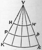
Fig. 17.
The simple conical projection is therefore arrived at in this way: imagine a cone to touch the sphere along any selected parallel, the radius of this parallel on paper (Pp, fig. 17) will be r cot φ, where r is the radius of the sphere and φ is the latitude; or if the spheroidal shape is taken into account, the radius of the parallel on paper will be ν cot φ where ν is the normal terminated by the minor axis (the value ν can be found from ordinary geodetic tables). The meridians are generators of the cone and every parallel such as HH′ is a circle, concentric with the selected parallel Pp and distant from it the true rectified length of the meridian arc between them.
This projection has no merits as compared with the group just described. The errors of scale along the parallels increase rapidly as the selected parallel is departed from, the parallels on paper being always too large. As an example we may take the case of a map of South Africa of the same range as that of the example given in (a) above, viz. from 15° S. to 35° S. Let the selected parallel be 25° S.; the radius of this parallel on paper (taking the radius of the sphere as unity) is cot 25°; the radius of parallel 35° S. = radius of 25° − meridian distance between 25° and 35° = cot 25° − 10π/180 = 1.970. Also h = sin of selected latitude = sin 25°, and length on paper along parallel 35° of ω° = ωh × 1.970 = ω × 1.970 × sin 25°,
but length on sphere of ω = ω cos 35°,
hence scale error = 1.970 sin 25° − 1 = 1.6%,
cos 35°
an error which is more than twice as great as that obtained by method (a).
Bonne’s Projection.—This projection, which is also called the “modified conical projection,” is derived from the simple conical, just described, in the following way: a central meridian is chosen and drawn as a straight line; degrees of latitude spaced at the true rectified distances are marked along this line; the parallels are concentric circular arcs drawn through the proper points on the central meridian, the centre of the arcs being fixed by describing one chosen parallel with a radius of ν cot φ as before; the meridians on each side of the central meridian are drawn as follows: along each parallel distances are marked equal to the true lengths along the parallels on sphere or spheroid, and the curve through corresponding points so fixed are the meridians (fig. 18).
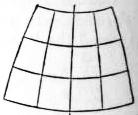
Fig. 18.
This system is that which was adopted in 1803 by the “Dépôt de la Guerre” for the map of France, and is there known by the title of Projection de Bonne. It is that on which the ordnance survey map of Scotland on the scale of 1 in. to a mile is constructed, and it is frequently met with in ordinary atlases. It is ill-adapted for countries having great extent in longitude, as the intersections of the meridians and parallels become very oblique—as will be seen on examining the map of Asia in most atlases.
If φ0 be taken as the latitude of the centre parallel, and co-ordinates be measured from the intersection of this parallel with the central meridian, then, if ρ be the radius of the parallel of latitude φ, we have ρ = cot φ0 + φ0 − φ. Also, if S be a point on this parallel whose co-ordinates are x, y, so that VS = ρ, and θ be the angle VS makes with the central meridian, then ρθ = ω cos φ; and x = ρ sin θ, y = cot φ0 − ρ cos θ.
The projection has the property of equal areas, since each small element bounded by two infinitely close parallels is equal in length and width to the corresponding element on the sphere or spheroid. Also all the meridians cross the chosen parallel (but no other) at right angles, since in the immediate neighbourhood of that parallel the projection is identical with the simple conical projection. Where an equal-area projection is required for a country having no great extent in longitude, such as France, Scotland or Madagascar, this projection is a good one to select.
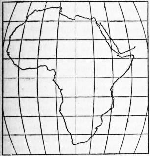
Fig. 19.—Sinusoidal Equal-area Projection.
Sinusoidal Equal-area Projection.—This projection, which is sometimes known as Sanson’s, and is also sometimes incorrectly called Flamsteed’s, is a particular case of Bonne’s in which the selected parallel is the equator. The equator is a straight line at right angles to the central meridian which is also a straight line. Along the central meridian the latitudes are marked off at the true rectified distances, and from points so found the parallels are drawn as straight lines parallel to the equator, and therefore at right angles to the central meridian. True rectified lengths are marked along the parallels and through corresponding points the meridians are drawn. If the earth is treated as a sphere the meridians are clearly sine curves, and for this reason d’Avezac has given the projection the name sinusoidal. But it is equally easy to plot the spheroidal lengths. It is a very suitable projection for an equal-area map of Africa.
Werner’s Projection.—This is another limiting case of Bonne’s equal-area projection in which the selected parallel is the pole. The parallels on paper then become incomplete circular arcs of which the pole is the centre. The central meridian is still a straight line which is cut by the parallels at true distances. The projection (after Johann Werner, 1468-1528), though interesting, is practically useless.
Polyconic Projections.
These pseudo-conical projections are valuable not so much for their intrinsic merits as for the fact that they lend themselves to tabulation. There are two forms, the simple or equidistant polyconic, and the rectangular polyconic.
The Simple Polyconic.—If a cone touches the sphere or spheroid along a parallel of latitude φ and is then unrolled, the parallel will on paper have a radius of ν cot φ, where ν is the normal terminated by the minor axis. If we imagine a series of cones, each of which touches one of a selected series of parallels, the apex of each cone will lie on the prolonged axis of the spheroid; the generators of each cone lie in meridian planes, and if each cone is unrolled and the generators in any one plane are superposed to form a straight central meridian, we obtain a projection in which the central meridian is a straight line and the parallels are circular arcs each of which has a different centre which lies on the prolongation of the central meridian, the radius of any parallel being ν cot φ.
So far the construction is the same for both forms of polyconic. In the simple polyconic the meridians are obtained by measuring outwards from the central meridian along each parallel the true lengths of the degrees of longitude. Through corresponding points so found the meridian curves are drawn. The resulting projection is accurate near the central meridian, but as this is departed from the parallels increasingly separate from each other, and the parallels and meridians (except along the equator) intersect at angles which increasingly differ from a right angle. The real merit of the projection is that each particular parallel has for every map the same absolute radius, and it is thus easy to construct tables which shall be of universal use. This is especially valuable for the projection of single sheets on comparatively large scales. A sheet of a degree square on a scale of 1 : 250,000 projected in this manner differs inappreciably from the same sheet projected on a better system, e.g. an orthomorphic conical projection or the conical with rectified meridians and two standard parallels; there is thus the advantage that the simple polyconic when used for single sheets and large scales is a sufficiently close approximation to the better forms of conical projection. The simple polyconic is used by the topographical section of the general staff, by the United States coast and geodetic survey and by the topographical division of the U.S. geological survey. Useful tables, based on Clarke’s spheroid of 1866, have been published by the war office and by the U.S. coast and geodetic survey.
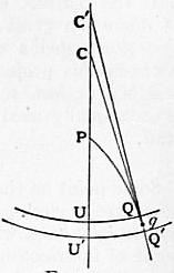
Fig. 20.
Rectangular Polyconic.—In this the central meridian and the parallels are drawn as in the simple polyconic, but the meridians are curves which cut the parallels at right angles.
In this case, let P (fig. 20) be the north pole, CPU the central meridian, U, U′ points in that meridian whose co-latitudes are z and z+dz, so that UU′ = dz. Make PU = z, UC = tan z, U′C′ = tan (z + dz); and with CC′ as centres describe the arcs UQ, U′Q′, which represent the parallels of co-latitude z and z + dz. Let PQQ′ be part of a meridian curve cutting the parallels at right angles. Join CQ, C′Q′; these being perpendicular to the circles will be tangents to the curve. Let UCQ = 2α, UC′Q′ = 2(α + dα), then the small angle CQC′, or the angle between the tangents at QQ′, will = 2dα. Now
CC′ = C′U′ − CU − UU′ = tan (z + dz) − tan z − dz = tan2 z dz.
The tangents CQ, C′Q′ will intersect at q, and in the triangle CC′q the perpendicular from C on C′q is (omitting small quantities of the second order) equal to either side of the equation
tan2 z dz sin 2α = −2 tan zd α. −tan z dz = 2 dα / sin 2α,
which is the differential equation of the meridian: the integral is tan α = ω cos z, where ω, a constant, determines a particular meridian curve. The distance of Q from the central meridian, tan z sin 2α, is equal to
2 tan z tan α = 2ω sin z .
1 + tan2 α 1 + ω2 cos2 α
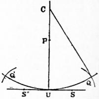
Fig. 21.
At the equator this becomes simply 2ω. Let any equatorial point whose actual longitude is 2ω be represented by a point on the developed equator at the distance 2ω from the central meridian, then we have the following very simple construction (due to O’Farrell of the ordnance survey). Let P (fig. 21) be the pole, U any point in the central meridian, QUQ′ the represented parallel whose radius CU = tan z. Draw SUS′ perpendicular to the meridian through U; then to determine the point Q, whose longitude is, say, 3°, lay off US equal to half the true length of the arc of parallel on the sphere, i.e. 1° 30′ to radius sin z, and with the centre S and radius SU describe a circular arc, which will intersect the parallel in the required point Q. For if we suppose 2ω to be the longitude of the required point Q, US is by construction = ω sin z, and the angle subtended by SU at C is
tan−1 ( ω sin z ) = tan−1 (ω cos z) = α,
tan z
and therefore UCQ = 2α as it should be. The advantages of this method are that with a remarkably simple and convenient mode of construction we have a map in which the parallels and meridians intersect at right angles.
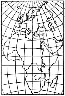
Fig. 22.
Fig. 22 is a representation of this system of the continents of Europe and Africa, for which it is well suited. For Asia this system would not do, as in the northern latitudes, say along the parallel of 70°, the representation is much cramped.
With regard to the distortion in the map of Africa as thus constructed, consider a small square in latitude 40° and in 40° longitude east or west of the central meridian, the square being so placed as to be transformed into a rectangle. The sides, originally unity, became 0.95 and 1.13, and the area 1.08, the diagonals intersecting at 90° ± 9° 56′. In Clarke’s perspective projection a square of unit side occupying the same position, when transformed to a rectangle, has its sides 1.02 and 1.15, its area 1.17, and its diagonals intersect at 90° ± 7° 6′. The latter projection is therefore the best in point of “similarity,” but the former represents areas best. This applies, however, only to a particular part of the map; along the equator towards 30° or 40° longitude, the polyconic is certainly inferior, while along the meridian it is better than the perspective—except, of course, near the centre. Upon the whole the more even distribution of distortion gives the advantage to the perspective system. For single sheets on large scales there is nothing to choose between this projection and the simple polyconic. Both are sensibly perfect representations. The rectangular polyconic is occasionally used by the topographical section of the general staff.
Zenithal Projections.
Some point on the earth is selected as the central point of the map; great circles radiating from this point are represented by straight lines which are inclined at their true angles at the point of intersection. Distances along the radiating lines vary according to any law outwards from the centre. It follows (on the spherical assumption), that circles of which the selected point is the centre are also circles on the projection. It is obvious that all perspective projections are zenithal.
Equidistant Zenithal Projection.—In this projection, which is commonly called the “equidistant projection,” any point on the sphere being taken as the centre of the map, great circles through this point are represented by straight lines of the true rectified lengths, and intersect each other at the true angles.
In the general case—
if z1 is the co-latitude of the centre of the map, z the co-latitude of any other point, α the difference of longitude of the two points, A the azimuth of the line joining them, and c the spherical length of the line joining them, then the position of the intersection of any meridian with any parallel is given (on the spherical assumption) by the solution of a simple spherical triangle.
Thus—
let tan θ = tan z cos α, then cos c = cos z sec θ cos (z − θ), and sin A = sin z sin α cosec c.
The most useful case is that in which the central point is the pole; the meridians are straight lines inclined to each other at the true angular differences of longitude, and the parallels are equidistant circles with the pole as centre. This is the best projection to use for maps exhibiting the progress of polar discovery, and is called the polar equidistant projection. The errors are smaller than might be supposed. There are no scale errors along the meridians, and along the parallels the scale error is (z / sin x) − 1, where z is the co-latitude of the parallel. On a parallel 10° distant from the pole the error of scale is only 0.5%.
General Theory of Zenithal Projections.—For the sake of simplicity it will be at first assumed that the pole is the centre of the map, and that the earth is a sphere. According to what has been said above, the meridians are now straight lines diverging from the pole, dividing the 360° into equal angles; and the parallels are represented by circles having the pole as centre, the radius of the parallel whose co-latitude is z being ρ, a certain function of z. The particular function selected determines the nature of the projection.
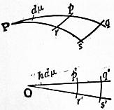
Fig. 23.
Let Ppq, Prs (fig. 23) be two contiguous meridians crossed by parallels rp, sq, and Op′q′, Or′s′ the straight lines representing these meridians. If the angle at P is dμ, this also is the value of the angle at O. Let the co-latitude
Pp = z, Pq = z + dz; Op′ = ρ, Oq′ = ρ + dρ,
the circular arcs p′r′, q′s′ representing the parallels pr, qs. If the radius of the sphere be unity,
p′q′ = dρ; p′r′ = ρ dμ, pq = dz; pr = sin z dμ.
Put
σ = dρ / dz; σ′ = ρ / sin z,
then p′q′ = σpq and p′r′ = σ′pr. That is to say, σ, σ′ may be regarded as the relative scales, at co-latitude z, of the representation, σ applying to meridional measurements, σ′ to measurements perpendicular to the meridian. A small square situated in co-latitude z, having one side in the direction of the meridian—the length of its side being i—is represented by a rectangle whose sides are iσ and iσ′; its area consequently is i2σσ′.
If it were possible to make a perfect representation, then we should have σ = 1, σ′ = 1 throughout. This, however, is impossible. We may make σ = 1 throughout by taking ρ = z. This is the Equidistant Projection just described, a very simple and effective method of representation.
Or we may make σ′= 1 throughout. This gives ρ = sin z, a perspective projection, namely, the Orthographic.
Or we may require that areas be strictly represented in the development. This will be effected by making σσ′ = 1, or ρ dρ = sin z dz, the integral of which is ρ = 2 sin 1⁄2z, which is the Zenithal Equal-area Projection of Lambert, sometimes, though wrongly referred to as Lorgna’s Projection after Antonio Lorgna (b. 1736). In this system there is misrepresentation of form, but no misrepresentation of areas.
Or we may require a projection in which all small parts are to be represented in their true forms i.e. an orthomorphic projection. For instance, a small square on the spherical surface is to be represented as a small square in the development. This condition will be attained by making σ = σ′, or dρ/ρ = dz/sin z, the integral of which is, c being an arbitrary constant, ρ = c tan 1⁄2z. This, again, is a perspective projection, namely, the Stereographic. In this, though all small parts of the surface are represented in their correct shapes, yet, the scale varying from one part of the map to another, the whole is not a similar representation of the original. The scale, σ = 1⁄2c sec2 1⁄2z, at any point, applies to all directions round that point.
These two last projections are, as it were, at the extremes of the scale; each, perfect in its own way, is in other respects objectionable. We may avoid both extremes by the following considerations. Although we cannot make σ = 1 and σ′ = 1, so as to have a perfect picture of the spherical surface, yet considering σ − 1 and σ′ − 1 as the local errors of the representation, we may make (σ − 1)2 + (σ′ − 1)2 a minimum over the whole surface to be represented. To effect this we must multiply this expression by the element of surface to which it applies, viz. sin zd zd μ, and then integrate from the centre to the (circular) limits of the map. Let β be the spherical radius of the segment to be represented, then the total misrepresentation is to be taken as
∫β0 { ( dρ − 1 )2 + ( ρ − 1 )2 } sin z dz,
dz sin z
which is to be made a minimum. Putting ρ = z + y, and giving to y only a variation subject to the condition δy = 0 when z = 0, the equations of solution—using the ordinary notation of the calculus of variations—are
N − d(P) = 0; Pβ = 0,
dz
Pβ being the value of 2p sin z when z = β. This gives
sin2 z d2y + sin z cos z dy − y = z − sin z ( dy ) β = 0.
dz2 dz dz
This method of development is due to Sir George Airy, whose original paper—the investigation is different in form from the above, which is due to Colonel Clarke—will be found in the Philosophical Magazine for 1861. The solution of the differential equation leads to this result—
ρ = 2 cot 1⁄2z loge sec 1⁄2z + C tan 1⁄2z,
C = 2 cot2 1⁄2β loge sec 1⁄2β.
The limiting radius of the map is R = 2C tan 1⁄2β. In this system, called by Sir George Airy Projection by balance of errors, the total misrepresentation is an absolute minimum. For short it may be called Airy’s Projection.
Returning to the general case where ρ is any function of z, let us consider the local misrepresentation of direction. Take any indefinitely small line, length = i, making an angle α with the meridian in co-latitude z. Its projections on a meridian and parallel are i cos α, i sin α, which in the map are represented by iσ cos α, iσ′ sin α. If then α′ be the angle in the map corresponding to α,
tan α′ = (σ′ / σ) tan α.
Put
σ′ / σ = ρ dz / sin z dρ = Σ,
and the error α′ − α of representation = ε, then
tan ε = (Σ − 1) tan α .
1 + Σ tan2 α
Put Σ = cot2 ζ, then ε is a maximum when α = ζ, and the corresponding value of ε is
ε = 1⁄2π − 2ζ.
For simplicity of explanation we have supposed this method of development so applied as to have the pole in the centre. There is, however, no necessity for this, and any point on the surface of the sphere may be taken as the centre. All that is necessary is to calculate by spherical trigonometry the azimuth and distance, with reference to the assumed centre, of all the points of intersection of meridians and parallels within the space which is to be represented in a plane. Then the azimuth is represented unaltered, and any spherical distance z is represented by ρ. Thus we get all the points of intersection transferred to the representation, and it remains merely to draw continuous lines through these points, which lines will be the meridians and parallels in the representation.
Thus treating the earth as a sphere and applying the Zenithal Equal-area Projection to the case of Africa, the central point selected being on the equator, we have, if θ be the spherical distance of any point from the centre, φ, α the latitude and longitude (with reference to the centre), of this point, cos θ = cos φ cos α. If A is the azimuth of this point at the centre, tan A = sin α cot φ. On paper a line from the centre is drawn at an azimuth A, and the distance θ is represented by 2 sin 1⁄2θ. This makes a very good projection for a single-sheet equal-area map of Africa. The exaggeration in such systems, it is important to remember, whether of linear scale, area, or angle, is the same for a given distance from the centre, whatever be the azimuth; that is, the exaggeration is a function of the distance from the centre only.
General Theory of Conical Projections.
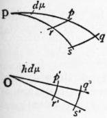
Fig. 24.
Meridians are represented by straight lines drawn through a point, and a difference of longitude ω is represented by an angle hω. The parallels of latitude are circular arcs, all having as centre the point of divergence of the meridian lines. It is clear that perspective and zenithal projections are particular groups of conical projections.
Let z be the co-latitude of a parallel, and ρ, a function of z, the radius of the circle representing this parallel. Consider the infinitely small space on the sphere contained by two consecutive meridians, the difference of whose longitude is dμ, and two consecutive parallels whose co-latitudes are z and z + dz. The sides of this rectangle are pq = dz, pr = sin z dμ; in the projection p′q′r′s′ these become p′q′ = dρ, and p′r′ = ρhdμ.
The scales of the projection as compared with the sphere are p′q′/pq = dρ/dz = the scale of meridian measurements = σ, say, and p′r′/pr = ρhdμ/sin zdμ = ρh/sin z = scale of measurements perpendicular to the meridian = σ′, say.
Now we may make σ = 1 throughout, then ρ = z + const. This gives either the group of conical projections with rectified meridians, or as a particular case the equidistant zenithal.
We may make σ = σ′ throughout, which is the same as requiring that at any point the scale shall be the same in all directions. This gives a group of orthomorphic projections.
In this case dρ/dz = ρh/sin z, or dρ/ρ = h dz/sin z.
Integrating,
ρ = k(tan 1⁄2z)h,
(i.)
where k is a constant.
Now h is at our disposal and we may give it such a value that two selected parallels are of the correct lengths. Let z1, z2 be the co-latitudes of these parallels, then it is easy to show that
h = log sin z1 − log sin z2 .
log tan 1⁄2z1 − log tan 1⁄2z2
(ii.)
This projection, given by equations (i.) and (ii.), is Lambert’s orthomorphic projection—commonly called Gauss’s projection; its descriptive name is the orthomorphic conical projection with two standard parallels.
The constant k in (i.) defines the scale and may be used to render the scale errors along the selected parallels not nil but the same; and some other parallel, e.g. the central parallel may then be made errorless.
The value h = 1⁄3, as suggested by Sir John Herschel, is admirably suited for a map of the world. The representation is fan-shaped, with remarkably little distortion (fig. 24).
If any parallel of co-latitude z is true to scale hk(tan 1⁄2z1)h = sin z, if this parallel is the equator, so that z1 = 90°, kh = 1, then equation (i.) becomes ρ = (tan 1⁄2z)h/h, and the radius of the equator = 1/h. The distance r of any parallel from the equator is 1/h − (tan 1⁄2z)h/h = (1/h){1 − (tan 1⁄2z)h}.
If, instead of taking the radius of the earth as unity we call it a, r = (a/h){1 − (tan 1⁄2z)h}. When h is very small, the angles between the meridian lines in the representation are very small; and proceeding to the limit, when h is zero the meridians are parallel—that is, the vertex of the cone has removed to infinity. And at the limit when h is zero we have r = a loge cot 1⁄2z, which is the characteristic equation of Mercator’s projection.
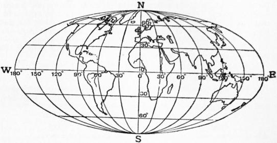
Fig. 25.—Elliptical equal-area Projection, showing the whole surface of the globe.
Mercator’s Projection.—From the manner in which we have arrived at this projection it is clear that it retains the characteristic property of orthomorphic projections—namely, similarity of representation of small parts of the surface. In Mercator’s chart the equator is represented by a straight line, which is crossed at right angles by a system of parallel and equidistant straight lines representing the meridians. The parallels are straight lines parallel to the equator, and the distance of the parallel of latitude φ from the equator is, as we have seen above, r = a loge tan (45° + 1⁄2φ). In the vicinity of the equator, or indeed within 30° of latitude of the equator, the representation is very accurate, but as we proceed northwards or southwards the exaggeration of area becomes larger, and eventually excessive—the poles being at infinity. This distance of the parallels may be expressed in the form r = a (sin φ + 1⁄3 sin3 φ + 1⁄5 sin5 φ + ...), showing that near the equator r is nearly proportional to the latitude. As a consequence of the similar representation of small parts, a curve drawn on the sphere cutting all meridians at the same angle—the loxodromic curve—is projected into a straight line, and it is this property which renders Mercator’s chart so valuable to seamen. For instance: join by a straight line on the chart Land’s End and Bermuda, and measure the angle of intersection of this line with the meridian. We get thus the bearing which a ship has to retain during its course between these ports. This is not great-circle sailing, and the ship so navigated does not take the shortest path. The projection of a great circle (being neither a meridian nor the equator) is a curve which cannot be represented by a simple algebraic equation.
If the true spheroidal shape of the earth is considered, the semiaxes being a and b, putting e = √(a2 − b2) / a, and using common logarithms, the distance of any parallel from the equator can be shown to be
(a / M) {log tan (45° + 1⁄2φ) − e2 sin φ − 1⁄3 e4 sin3 φ ...}
where M, the modulus of common logarithms, = 0.434294. Of course Mercator’s projection was not originally arrived at in the manner above described; the description has been given to show that Mercator’s projection is a particular case of the conical orthomorphic group. The introduction of the projection is due to the fact that for navigation it is very desirable to possess charts which shall give correct local outlines (i.e. in modern phraseology shall be orthomorphic) and shall at the same time show as a straight line any line which cuts the meridians at a constant angle. The latter condition clearly necessitates parallel meridians, and the former a continuous increase of scale as the equator is departed from, i.e. the scale at any point must be equal to the scale at the equator × sec. latitude. In early days the calculations were made by assuming that for a small increase of latitude, say 1′, the scale was constant, then summing up the small lengths so obtained. Nowadays (for simplicity the earth will be taken as a sphere) we should say that a small length of meridian adφ is represented in this projection by a sec φ dφ, and the length of the meridian in the projection between the equator and latitude φ,
√φ0 a sec φ dφ = a loge tan (45° + 1⁄2φ),
which is the direct way of arriving at the law of the construction of this very important projection.
Mercator’s projection, although indispensable at sea, is of little value for land maps. For topographical sheets it is obviously unsuitable; and in cases in which it is required to show large areas on small scales on an orthomorphic projection, that form should be chosen which gives two standard parallels (Lambert’s conical orthomorphic). Mercator’s projection is often used in atlases for maps of the world. It is not a good projection to select for this purpose on account of the great exaggeration of scale near the poles. The misconceptions arising from this exaggeration of scale may, however, be corrected by the juxtaposition of a map of the world on an equal-area projection.
It is now necessary to revert to the general consideration of conical projections.
It has been shown that the scales of the projection (fig. 23) as compared with the sphere are p′q′ / pq = dp / dz = σ along a meridian, and p′r′ / pr′ = ρh / sin z = σ′ at right angles to a meridian.
Now if σσ′ = 1 the areas are correctly represented, then
hρ dρ = sin z dz, and integrating 1⁄2hρ2 = C − cos z;
(i.)
this gives the whole group of equal-area conical projections.
As a special case let the pole be the centre of the projected parallels, then when
z = 0, ρ = 0, and const = 1, we have p = 2 sin 1⁄2z / δh
(ii.)
Let z1 be the co-latitude of some parallel which is to be correctly represented, then 2h sin 1⁄2z1 / δh = sin z1, and h = cos2 1⁄2z1; putting this value of h in equation (ii.) the radius of any parallel
= ρ = 2 sin 1⁄2z sec 1⁄2z1
(iii.)
This is Lambert’s conical equal-area projection with one standard parallel, the pole being the centre of the parallels.
If we put z1=θ, then h = 1, and the meridians are inclined at their true angles, also the scale at the pole becomes correct, and equation (iii.) becomes
ρ = 2 sin 1⁄2z;
(iv.)
this is the zenithal equal-area projection.
Reverting to the general expression for equal-area conical projections
ρ = √{2 (C − cos z) / h},
(i.)
we can dispose of C and h so that any two selected parallels shall be their true lengths; let their co-latitudes be z1 and z2, then
2h (C − cos z1) = sin2 z1
(v.)
2h (C − cos z2) = sin2 z2
(vi.)
from which C and h are easily found, and the radii are obtained from (i.) above. This is H. C. Albers’ conical equal-area projection with two standard parallels. The pole is not the centre of the parallels.
Projection by Rectangular Spheroidal Co-ordinates.
If in the simple conical projection the selected parallel is the equator, this and the other parallels become parallel straight lines and the meridians are straight lines spaced at equatorial distances, cutting the parallels at right angles; the parallels are their true distances apart. This projection is the simple cylindrical. If now we imagine the touching cylinder turned through a right-angle In such a way as to touch the sphere along any meridian, a projection is obtained exactly similar to the last, except that in this case we represent, not parallels and meridians, but small circles parallel to the given meridian and great circles at right angles to it. It is clear that the projection is a special case of conical projection. The position of any point on the earth’s surface is thus referred, on this projection, to a selected meridian as one axis, and any great circle at right angles to it as the other. Or, in other words, any point is fixed by the length of the perpendicular from it on to the fixed meridian and the distance of the foot of the perpendicular from some fixed point on the meridian, these spherical or spheroidal co-ordinates being plotted as plane rectangular co-ordinates.
The perpendicular is really a plane section of the surface through the given point at right angles to the chosen meridian, and may be briefly called a great circle. Such a great circle clearly diverges from the parallel; the exact difference in latitude and longitude between the point and the foot of the perpendicular can be at once obtained by ordinary geodetic formulae, putting the azimuth = 90°. Approximately the difference of latitude in seconds is x2 tan φ cosec 1″ / 2ρν where x is the length of the perpendicular, ρ that of the radius of curvature to the meridian, ν that of the normal terminated by the minor axis, φ the latitude of the foot of the perpendicular. The difference of longitude in seconds is approximately x sec ρ cosec 1″ / ν. The resulting error consists principally of an exaggeration of scale north and south and is approximately equal to sec x (expressing x in arc); it is practically independent of the extent in latitude.
It is on this projection that the 1/2,500 Ordnance maps and the 6-in. Ordnance maps of the United Kingdom are plotted, a meridian being chosen for a group of counties. It is also used for the 1-in., 1⁄2 in. and 1⁄4 in. Ordnance maps of England, the central meridian chosen being that which passes through a point in Delamere Forest in Cheshire. This projection should not as a rule be used for topographical maps, but is suitable for cadastral plans on account of the convenience of plotting the rectangular co-ordinates of the very numerous trigonometrical or traverse points required in the construction of such plans. As regards the errors involved, a range of about 150 miles each side of the central meridian will give a maximum error in scale in a north and south direction of about 0.1%.
Elliptical Equal-area Projection.
In this projection, which is also called Mollweide’s projection the parallels are parallel straight lines and the meridians are ellipses, the central meridian being a straight line at right angles to the equator, which is equally divided. If the whole world is represented on the spherical assumption, the equator is twice the length of the central meridian. Each elliptical meridian has for one axis the central meridian, and for the other the intercepted portion of the equally divided equator. It follows that the meridians 90° east and west of the central meridian form a circle. It is easy to show that to preserve the property of equal areas the distance of any parallel from the equator must be √2 sin δ where π sin φ = 2δ + sin 2δ, φ being the latitude of the parallel. The length of the central meridian from pole to pole = 2 √2, where the radius of the sphere is unity. The length of the equator = 4 √2.
The following equal-area projections may be used to exhibit the entire surface of the globe: Cylindrical equal area, Sinusoidal equal area and Elliptical equal area.
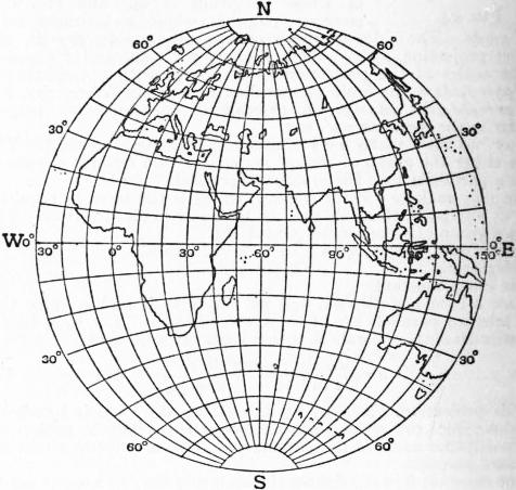
Fig. 26.—Globular Projection.
Conventional or Arbitrary Projections.
These projections are devised for simplicity of drawing and not for any special properties. The most useful projection of this class is the globular projection. This is a conventional representation of a hemisphere in which the equator and central meridian are two equal straight lines at right angles, their intersection being the centre of the circular boundary. The meridians divide the equator into equal parts and are arcs of circles passing through points so determined and the poles. The parallels are arcs of circles which divide the central and extreme meridians into equal parts. Thus in fig. 26 NS = EW and each is divided into equal parts (in this case each division is 10°); the circumference NESW is also divided into 10° spaces and circular arcs are drawn through the corresponding points. This is a simple and effective projection and one well suited for conveying ideas of the general shape and position of the chief land masses; it is better for this purpose than the stereographic, which is commonly employed in atlases.
(From Text Book of Topographical Surveying, by permission of the Controller of H.M. Stationery Office.)
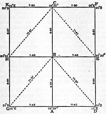
Fig. 27.—Plane Table Graticule, dimensions in inches, for a scale of 4 in. to 1 m.
Projections for Field Sheets.
Field sheets for topographical surveys should be on conical projections with rectified meridians; these projections for small areas and ordinary topographical scales—not less than 1/500,000—are sensibly errorless. But to save labour it is customary to employ for this purpose either form of polyconic projection, in which the errors for such scales are also negligible. In some surveys, to avoid the difficulty of plotting the flat arcs required for the parallels, the arcs are replaced by polygons, each side being the length of the portion of the arc it replaces. This method is especially suitable for scales of 1 : 125,000 and larger, but it is also sometimes used for smaller scales.
Fig. 27 shows the method of plotting the projection for a field sheet. Such a projection is usually called a graticule. In this case ABC is the central meridian; the true meridian lengths of 30′ spaces are marked on this meridian, and to each of these, such as AB, the figure (in this case representing a square half degree), such as ABED, is applied. Thus the point D is the intersection of a circle of radius AD with a circle of radius BD, these lengths being taken from geodetic tables. The method has no merit except that of convenience.
Summary.
The following projections have been briefly described:—
Perspective 1. Cylindrical equal-area.
2. Orthographic.
3. Stereographic (which is orthomorphic).
4. General external perspective.
5. Minimum error perspective. (Clarke’s).
6. Central.
Conical 7. Conical, with rectified meridians and two standard parallels (5 forms).
8. Simple conical.
9. Simple cylindrical (a special case of 8).
10. Modified conical equal-area (Bonne’s).
11. Sinusoidal equal-area (Sanson’s).
12. Werner’s conical equal-area
13. Simple polyconic.
14. Rectangular polyconic.
15. Conical orthomorphic with 2 standard parallels (Lambert’s, commonly called Gauss’s).
16. Cylindrical orthomorphic (Mercator’s).
17. Conical equal-area with one standard parallel.
18. Conical equal-area with two standard parallels.
19. Projection by rectangular spheroidal co-ordinates.
Zenithal 20. Equidistant zenithal.
21. Zenithal equal-area.
22. Zenithal projection by balance of errors (Airy’s).
23. Elliptical equal-area (Mollweide’s).
24. Globular (conventional).
25. Field sheet graticule.
Of the above 25 projections, 23 are conical or quasi-conical, if zenithal and perspective projections be included. The projections may, if it is preferred, be grouped according to their properties. Thus in the above list 8 are equal-area, 3 are orthomorphic, 1 balances errors, 1 represents all great circles by straight lines, and in 5 one system of great circles is represented correctly.
Among projections which have not been described may be mentioned the circular orthomorphic (Lagrange’s) and the rectilinear equal-area (Collignon’s) and a considerable number of conventional projections, which latter are for the most part of little value.
The choice of a projection depends on the function which the map is intended to fulfil. If the map is intended for statistical purposes to show areas, density of population, incidence of rainfall, of disease, distribution of wealth, &c., an equal-area projection should be chosen. In such a case an area scale should be given. At sea, Mercator’s is practically the only projection used except when it is desired to determine graphically great circle courses in great oceans, when the central projection must be employed. For conveying good general ideas of the shape and distribution of the surface features of continents or of a hemisphere Clarke’s perspective projection is the best. For exhibiting the progress of polar exploration the polar equidistant projection should be selected. For special maps for general use on scales of 1/1,000,000 and smaller, and for a series of which the sheets are to fit together, the conical, with rectified meridians and two standard parallels, is a good projection. For topographical maps, in which each sheet is plotted independently and the scale is not smaller than 1/500,000, either form of polyconic is very convenient.
The following are the projections adopted for some of the principal official maps of the British Empire:—
Conical, with Rectified Meridians and Two Standard Parallels.—The 1 : 1,000,000 Ordnance map of the United Kingdom, special maps of the topographical section, General Staff, e.g. the 64-mile map of Afghanistan and Persia. The 1 : 1,000,000 Survey of India series of India and adjacent countries.
Modified Conical, Equal-area (Bonne’s).—The 1 in., 1⁄2 in., 1⁄4 in. and 1⁄10 in. Ordnance maps of Scotland and Ireland. The 1 : 800,000 map of the Cape Colony, published by the Surveyor-General.
Simple Polyconic and Rectangular Polyconic maps on scales of 1 : 1,000,000, 1 : 500,000, 1 : 250,000 and 1 : 125,000 of the topographical section of the General Staff, including all maps on these scales of British Africa. A rectilinear approximation to the simple polyconic is also used for the topographical sheets of the Survey of India. The simple polyconic is used for the 1 in. maps of the Militia Department of Canada.
Zenithal Projection by Balance of Errors (Airy’s).—The 10-mile to 1 in. Ordnance map of England.
Projection by Rectangular Spheroidal Co-ordinates.—The 1 : 2500 and the 6 in. Ordnance sheets of the United Kingdom, and the 1 in., 1⁄2 in. and 1⁄4 in. Ordnance maps of England. The cadastral plans of the Survey of India, and cadastral plans throughout the empire.
Authorities.—See Traité des projections des cartes géographiques, by A. Germain (Paris, 1865) and A Treatise on Projections, by T. Craig, United States Coast and Geodetic Survey (Washington, 1882). Both Germain and Craig (following Germain) make use of the term projections by development, a term which is apt to convey the impression that the spherical surface is developable. As this is not the case, and since such projections are conical, it is best to avoid the use of the term. For the history of the subject see d’Avezac, “Coup d’œil historique sur la projection des cartes géographiques,” Société de géographie de Paris (1863).
J. H. Lambert (Beiträge zum Gebrauch der Mathematik, u.s.w. Berlin, 1772) devised the following projections of the above list: 1, 15, 17, and 21; his transverse cylindrical orthomorphic and the transverse cylindrical equal-area have not been described, as they are seldom used. Among other contributors we mention Mercator, Euler, Gauss, C. B. Mollweide (1774-1825), Lagrange, Cassini, R. Bonne (1727-1795), Airy and Colonel A. R. Clarke.
(C. F. Cl.; A. R. C.)
1 The ancient Greeks called a map Pinax, The Romans Tabula geographica. Mappa mundi was the medieval Latin for a map of the world which the ancients called Tabula totius orbis descriptionem continens.
2 Close, “The Ideal Topographical Map,” Geog. Journal, vol. xxv. (1905).
3 K. Peucker, Schattenplastik und Farbenplastik (Vienna, 1898); Geograph. Zeitschrift (1902 and 1908).
4 Professor Henrici, Report on Planimeters (64th meeting of the British Association, Oxford, 1894); J. Tennant, “The Planimeter” (Engineering, xlv. 1903).
5 H. Wagner’s Lehrbuch (Hanover, 1908, pp. 241-252) refers to numerous authorities who deal fully with the whole question of measurement.
6 Kienzl of Leoben in 1891 had invented a similar apparatus which he called a Relief Pantograph (Zeitschrift, Vienna Geog. Soc. 1891).
7 M. Fiorini, Erd- und Himmelsgloben, frei bearbeitet von S. Günther (Leipzig, 1895).
8 Jahrb. des polytechn. Instituts in Wien, vol. xv.
9 Compare the maps of Europe, Asia, &c., in this work.
10 The great majority of the maps in this work are made by this process.
11 Lepsius, Urkundenbuch, Pl. XXII.
12 These Colchians certainly were not Egyptians. The maps referred to may have been Assyrian.
13 We are indebted to Strabo for nearly all we know about Greek cartographers anterior to Ptolemy, for none of their maps has been preserved.
14 The gnomon was known to the Chinese in the 5th century B.C., and reached the Greeks (Anaximander) through Babylon. Pytheas, as far as known, was the first to utilize it for the determination of a latitude.
15 If, with W. Dörpfeld, we assume an Attic stadium of 200 steps (500 ft.) to be equal to 164 metres, a degree of 700 stad. would be equal to 114,800 metres, its actual length according to modern measurement being 110,808 metres.
16 Climata based on the length of the longest day were introduced by Hippocrates (c. 400 B.C.). Zones similar to those already drawn out for the celestial sphere were first introduced by the Pythagoreans. Parmenides of Elea (544-430 B.C.) distinguishes five of these zones, viz. a torrid zone, between the tropics of summer and winter, which was uninhabitable on account of heat; two frigid zones, uninhabitable on account of cold, and two intermediate temperate zones.
17 Celestial globes were made much earlier than terrestrial ones. In the museum of Naples there is a celestial globe, 2 metres in diameter, supported upon the shoulders of an Atlas, which E. Heis, judging by the constellations engraved upon it (Atlas coelestis novus, Bonn, 1872) judges to date from the 4th century B.C. It may even be the work of Eudoxus (d. 386 B.C.) the famous astronomer. Aratus of Soli in Cilicia, in his poetical Prognostics of Stars and the World, refers to a globe in his possession. Archimedes, the famous mathematician, had a celestial globe of glass, in the centre of which was a small terrestrial globe. Hero of Alexandria (284-221 B.C.), the ingenious inventor of “Hero’s Fountain,” is believed to have possessed a similar apparatus. The celestial globe of Hipparchus still existed in the Alexandrian library in the time of Ptolemy, who himself refers to globes in his Almagest, as also in the Geography. Leontius, who wrote a book on the manufacture of globes (first published at Basel in 1539), is identified by Fiorini with a bishop of Neapolis (Cyprus) of the time of Constantine III. (642-668).
18 The oldest MS. of Ptolemy’s Geography is found in the Vatopedi monastery of Mt Athos. It dates from the 12th or 13th century and was published by Victor Langlois in 1867. For the latest edition we are indebted to the late Carl Müller (Paris, 1883-1906) to whom we are likewise indebted for an edition of the Geographi graeci minores (1855-1861).
19 Facsimiles of it have been published by Desjardins(1869-1871), by K. Miller (1886), who ascribes it to Castorius, A.D. 366, and by others.
20 R. Gough, British Topography (London 1768). His “Histories” are published in Rerum brit. scriptores XL. and LVII. 1866-1869.
21 M. Bittner, Die topogr. Capital des ind. Seespiegels (Vienna, 1897).
22 E. G. Ravenstein, Martin Behaim, his Life and his Globe (London, 1908). On the original only equator, ecliptics, tropics, polar circles and one meridian 80° to the west of Lisbon are laid down.
23 See fig. 23, Catalan Map of the World (1375).
24 J. G. Kohl published facsimiles of the American section of the maps (Weimar, 1860).
25 Facsimiles of the maps of 1507 and 1517 were published by J. Fischer and F. M. von Wieser (Innsbruck, 1903).
26 See “The Survey in British Africa”: the Annual Report of the Colonial Survey Commission.
27 A. Germain, Traité des Projections (Paris, 1865).
28 T. Craig, A Treatise on Projections (U.S. Coast and Geodetic Survey, Washington, 1882).
29 This error is much less than that which may be expected from contraction and expansion of the paper upon which the projection is drawn or printed.

MAPLE, SIR JOHN BLUNDELL, Bart. (1845-1903), English business magnate, was born on the 1st of March 1845. His father, John Maple (d. 1900), had a small furniture shop in Tottenham Court Road, London, and his business began to develop about the time that his son entered it. The practical management soon devolved on the younger Maple, under whom it attained colossal dimensions. The firm became a limited liability company, with a capital of two millions, in 1890, with Mr Maple as chairman. He entered parliament as Conservative member for Dulwich in 1887, was knighted in 1892, and was made a baronet in 1897. He was the owner of a large stud of race-horses, and from 1885 onwards won many important races, appearing at first under the name of “Mr Childwick.” His public benefactions included a hospital and a recreation ground to the city of St Albans, near which his residence, Childwickbury, was situated, and the rebuilding, at a cost of more than £150,000, of University College Hospital, London. He died on the 24th of November 1903. His only surviving daughter married in 1896 Baron von Eckhardstein, of the German Embassy.
MAPLE, in botany. The maple (O.E. mapel-tréow, mapulder) and sycamore trees are species of Acer, of the order Acerineae. The genus includes about sixty species, natives of Europe, North America and Asia, especially the Himalayas, China and Japan. Maples are for the most part trees with opposite, long-stalked, palmately lobed leaves. The flowers are in fascicles, appearing before the leaves as in the Norway maple, or in racemes or panicles appearing with, or later than, the leaves as in sycamore. Some of the flowers are often imperfect, the stamens or pistil being more or less aborted. The fruit is a two-winged “samara.” The genus was represented in the Tertiary flora of Europe, when it extended into the polar regions; nineteen species have been recorded from the Miocene strata of Oeningen in Switzerland. The common maple, A. campestre, is the only species indigenous to Great Britain. This and the sycamore were described by Gerard in 1597 (Herball, p. 1299), the latter being “a stranger to England.” Many species have been introduced, especially from Japan, for ornamental purposes. The following are more especially worthy of notice.
Acer campestre, the common maple, is common in hedgerows, but less often seen as a tree, when it is seldom more than 20 ft. high, though in sheltered situations 30 ft. or more is attained. The leaves are generally less than 2 in. across, and the five main lobes are blunter than in the sycamore. The clusters of green flowers terminate the young shoots and are erect; the two wings of the fruit spread almost horizontally, and are smaller than in the sycamore. It occurs in northern Europe, the Caucasus, and northern Asia. The wood is excellent fuel, and makes the best charcoal. It is compact, of a fine grain, sometimes beautifully veined, and takes a high polish. Hence it has been celebrated from antiquity for tables, &c. The wood of the roots is frequently knotted, and valuable for small objects of cabinet work. The young shoots, being flexible and tough, are employed in France as whips.
A. pseudo-platanus, the sycamore or great maple, is a handsome tree of quick growth, with a smooth bark. The leaves are large, with finely acute and serrated lobes, affording abundant shade. The flowers are borne in long pendulous racemes, and the two wings of the fruit are ascending. It lives from 140 to 200 years. It is found wild chiefly in wooded mountainous situations in central Europe. The wood when young is white, but old heartwood is yellow or brownish. Like the common maple it is hard and takes a high polish. It is much prized by wheelwrights, cabinet-makers, sculptors, &c., on the Continent; while knotted roots are used for inlaying. Sugar has been obtained from the sap of this as from other species, the most being one ounce from a quart of sap. The latter has also been made into wine in the Highlands of Scotland. It withstands the sea and mountain breezes better than most other timber trees, and is often planted near farm-houses and cottages in exposed localities for the sake of its dense foliage. Its wood is valued in turnery for cups, bowls and pattern blocks. It produces abundance of seeds, and is easily raised, but it requires good and tolerably dry soil; it will not thrive on stiff clays nor on dry sands or chalks. There are many varieties, the variegated and cut-leaved being the most noticeable. The lobed shape of its leaf and its dense foliage caused it to be confused with the true sycamore—Ficus sycamorus—of scripture.
A. platanoides, the Norway maple, is met with from Norway to Italy, Greece, and central and south Russia. It was introduced into Britain in 1683. It is a lofty tree (from 40 to 70 ft.), resembling the sycamore, but with yellow flowers, appearing before the leaves, and more spreading wings to the fruit. There are several varieties. The wood is used for the same purposes as that of the sycamore. Sugar has been made from the sap in Norway and Sweden.
Many varieties of A. palmatum, generally known as polymorphum, with variously laciniated and more or less coloured foliage, have been introduced from Japan as ornamental shrubs. The branches and corolla are purple, the fruit woolly. The foliage of the typical form is bright green with very pointed lobes. It occurs in the central mountains of Nippon and near Nagasaki. Beautiful varieties have been introduced under the varietal names, ampelopsifolium, atropurpureum, dissectum, &c. They are remarkable for the coppery purple tint that pervades the leaves and young growths of some of the varieties. Other Japanese species are A. japonicum, the varieties of which are among the most handsome of small deciduous shrubs; A. rufinerve, with the habit of the sycamore; A. distylum, bearing leaves without lobes; A. diabolicum, with large plane-like leaves; and A. carpinifolium, with foliage resembling that of the hornbeam.
A. saccharinum, a North American species, the sugar, rock, or bird’s-eye maple, was introduced in 1735. It sometimes attains to 70 or even over 100 ft., more commonly 50 to 60 ft. It is remarkable for the whiteness of the bark. The wood is white, but acquires a rosy tinge after exposure to light. The grain is fine and close, and when polished has a silky lustre. The timber is used instead of oak where the latter is scarce, and is employed for axle-trees and spokes, as well as for Windsor chairs, &c. It exhibits two accidental forms in the arrangement of the fibres, an undulated one like those of the curled maple (A. rubrum), and one of spots, which gives the name bird’s-eye to the wood of this species. Like the curled maple, it is used for inlaying mahogany. It is much prized for bedsteads, writing-desks, shoe-lasts, &c. The wood forms excellent fuel and charcoal, while the ashes are rich in alkaline principles, furnishing a large proportion of the potash exported from Boston and New York. Sugar is principally extracted from this species, the sap being boiled and the syrup when reduced to a proper consistence runs into moulds to form cakes. Trees growing in low and moist situations afford the most sap but least sugar. A cold north-west wind, with frosty nights and sunny days in alternation, tends to incite the flow, which is more abundant during the day than the night. A thawing night is said to promote the flow, and it ceases during a south-west wind and at the approach of a storm; and so sensitive are the trees to aspect and climatic variations that the flow of sap on the south and east side has been noticed to be earlier than on the north and west side of the same tree. The average quantity of sap per tree is from 12 to 24 gallons in a season.
A. rubrum, the red-flowering or scarlet maple, is a middle-sized tree, and was introduced in 1656. The bright scarlet or dull red flowers appear before the leaves in March and April. The wood, like that of other species, is applicable to many purposes—as for the seats of Windsor chairs, turnery, &c. The grain in very old trees is sometimes undulated, which suggested the name of curled maple, and gives beautiful effects of light and shade on polished surfaces. The most constant use of curled maple is for the stocks of fowling-pieces and rifles, as it affords toughness and strength combined with lightness and elegance. The inner bark is dusky red. On boiling, it yields a purple colour which with sulphate of iron affords a black dye. The wood is inferior to that of the preceding species in strength and as fuel. Sugar was made from the sap by the French Canadians, but the production is only half as great as that from the sugar maple. In Britain it is cultivated as an ornamental tree, as being conspicuous for its flowers in spring, and for its red fruit and foliage in autumn.
A. macrophyllum, a north-western American species, is a valuable timber tree.
For a good account of the North American species see C. S. Sargent’s Silva of North America, vol. ii. See also under Sugar.
MAPU, ABRAHAM (1808-1867), Hebrew novelist. His works are chiefly historical romances in Hebrew. His most famous books were The Love of Zion and the Transgression of Samaria. Besides their intrinsic merits, these novels stand high among the works which produced the romantic movement in modern Hebrew literature. Mapu’s plots were somewhat sensational, incident being more prominent than characterization. But underlying all was a criticism of contemporary life. His novels made a deep impression and became instantly popular. Mapu’s Hebrew style is simple and classical. An English translation of the Love of Zion bears the title Amnon, Prince and Peasant, by F. Jaffe (1887). Mapu’s stories have been often translated into other languages.
See N. Slouschz, The Renascence of Hebrew Literature (1909), ch. v.
(I. A.)
MAQQARĪ, or Maḳḳarī [Abū-l-‘Abbās Ahmad ibn Maḥommed ul-Maqqarī] (c. 1591-1632), Arabian historian, was born at Tlemcen in Algeria and studied at Fez and Marrakesh, where he remained engaged in literary work until he made the pilgrimage to Mecca in 1618. In the following year he settled in Cairo. In 1620 he visited Jerusalem and Damascus, and during the next six years made the pilgrimage five times. In 1628 he was again in Damascus, where he gave a course of lectures on Bukhārī’s collection of Traditions, spoke much of the glories of Moslem Spain, and received the impulse to write his work on this subject later. In the same year he returned to Cairo, where he spent a year in writing his history. He was just making preparations to settle definitely in Damascus when he died in 1632.
His great work, The Breath of Perfume from the Branch of Green Andalusia and Memorials of its Vizier Lisān ud-Dīn ibn ul-Khatīīb, consists of two parts. The first is a compilation from many authors on the description and history of Moslem Spain; it was published by Wright, Krehl, Dozy and Dugat as Analectes sur l’histoire et la littérature des Arabes d’Espagne (Leiden, 1855-1861), and in an abridged English translation by P. de Gayangos (London, 1840-1843). The whole work has been published at Būlāq (1863) and Cairo (1885).
For other works of Maqqarī see C. Brockelmann’s Gesch. der arabischen Litteratur (Berlin, 1902), ii. 297.
(G. W. T.)
MAQRĪZĪ, or Makrizi [Taqī ud-Dīn Aḥmad ibn ‘Alī] (1364-1442), Arabian historian, known as al-Maqrīzī because of his ancestral connexion with Maqrīz, a suburb of Baalbek, was born at Cairo and spent most of his life in Egypt, where he was trained in the Hanifite school of law, though later he became a Shāfi’ite with an inclination to Zāhirite views. In 1385 he made the pilgrimage. For some time he was secretary in a government office, and in 1399 became inspector of markets for Cairo and northern Egypt. This post he soon gave up to become preacher at the mosque of ‘Amr, president of the mosque ul-Hākim, and a lecturer on tradition. In 1408 he went to Damascus to become inspector of the Qalānisīyya and lecturer. Later he retired into private life at Cairo. In 1430 he made the pilgrimage with his family and travelled for some five years. His learning was great, his observation accurate and his judgment good, but his books are largely compilations, and he does not always acknowledge the sources to which he is indebted. Most of his works are concerned with Egypt. The most important is the Mawā‘iz wal-I’tibār fī dhikr ul-Ḥitaṭ wal-Āihār (2 vols., Bulāq, 1854), translated into French by U. Bouriant as Description topographique et historique de l’Égypte (Paris, 1895-1900; cf. A. R. Guest, “A List of Writers, Books and other Authorities mentioned by El Maqrīzī in his Khiṭat,” in Journal of the Royal Asiatic Society, 1902, pp. 103-125). Of his History of the Fatimites an extract was published by J. G. L. Kosegarten in his Chrestomathia (Leipzig, 1828), pp. 115-123; the History of the Ayyūbit and Mameluke Rulers has been translated into French by E. Quatremère (2 vols., Paris, 1837-1845). Maqrīzī began a large work called the Muqaffā, a cyclopaedia of Egyptian biography in alphabetic order. It was intended to be in 80 volumes, but only 16 were written. Three autograph volumes exist in MS. in Leiden, and one in Paris.
Among smaller works published are the Mahommedan Coinage (ed. O. G. Tychsen, Rostock, 1797; French translation by S. de Sacy, Paris, 1797); Arab Weights and Measures (ed. Tychsen, Rostock, 1800); the Arabian Tribes that migrated to Egypt (ed. F. Wüstenfeld, Göttingen, 1847); the Account of Hadhramaut (ed. P. B. Noskowyj, Bonn, 1866); the Strife between the Banī Umayya and the Banī Hāshim (ed G. Vos, Leiden, 1888), and the Moslems in Abyssinia (ed. F. T. Rink, Leiden, 1790). For Maqrīzī’s life see the quotations from contemporary biographies in S. de Sacy’s Chrestomathie arabe (2nd ed., Paris, 1826), ii. 112 seq., and for other works still in MS. C. Brockelmann, Gesch. der arabischen Litteratur (Berlin, 1902), ii. 38-41.
(G. W. T.)
MAR, EARLDOM OF. Mar, one of the ancient divisions or provinces of Scotland, comprised the larger portion of Aberdeenshire, extending from north of the Don southward to the Mounth. Like other such districts, it was in Celtic times under the rule of a mormaer. In the 12th century his place was taken by an earl, but no definite succession of earls appears till the 13th century, nor is any connexion established between them and the mormaers. From the middle of the 13th century the earls were recognized as among “the seven earls of Scotland” and held a great position. Earl Gratney (fl. c. 1300) married a sister of (King) Robert Bruce, who brought him the lordship of Garioch and castle of Kildrummy, which she held against the earl of Athole, an ally of the English (1335). Their son Donald was made regent in July 1332, but was disastrously defeated and slain at Dupplin next month. His daughter and eventual heir, Margaret, brought the earldom to her husband, William, earl of Douglas, and on the accession of her daughter Isabél a troublous time followed.
While she was living as a widow at her castle of Kildrummy, it was stormed by Alexander Stewart, a bastard, who forced her to execute a charter (August 12, 1404) settling the reversion to the earldom on himself and his heirs. This act she revoked by a charter of the 19th of September 1404, which cannot now be found; but on marrying him, on the 9th of December 1404, she granted him the earldom for life, the king confirming this on the 21st of June 1405. After her death in 1408 the earl played a great part, commanding the royal forces at the battle of Harlaw, when the Lord of the Isles was defeated in 1411, and afterwards acting as warden of the Marches. In 1426 he resigned the earldom to the Crown, the king granting it by a fresh creation to him and certain heirs, with reversion to the Crown. On the earl’s death in 1435 the earldom was claimed by Robert, Lord Erskine, as heir of Gratney, earl of Mar, through a daughter; but the Crown claimed as reversionary under the creation of 1426. A long struggle followed, till in 1457 James II. obtained from a justiciary court at Aberdeen a recognition of the Crown’s right to the earldom and its lands, and shortly after bestowed them on his son John as earl of Mar and Garioch. He died unmarried in 1479, and in 1483 his elder brother Alexander duke of Albany received the earldom, but was soon forfeited. James III. created his son John earl of Mar and Garioch in 1486, and after his death unmarried in 1503, James IV. alienated to Lord Elphinstone (1507-1510) many of the Mar lands, including Kildrummy. The title was not revived till 1562, when James Stewart, earl of Murray, held it for a few months.
In 1565 John, Lord Erskine, succeeded in getting returned heir to the earldom, and shortly after (June 23, 1565) Queen Margaret restored the charter to him and his heirs “all and hail the said earldom of Mar.” As earl he took part against the queen in 1567, and in 1571 was made regent of Scotland, which post he retained till his death (1572). His son, earl John (c. 1558-1634), played a great part in the history of the family. His great achievement was the recovery of the Mar estates, alienated by the Crown during the long period that his family had been out of possession, including Kildrummy, the “head” of the earldom. It was in his time that the precedence of the earldom (see below) was settled. John, the next earl (c. 1585-1654) was a Royalist, as was his son John (d. 1668), much to the injury of the family fortune, which was further impaired by the attachment of the family, after the Revolution, to the Stuarts. His son Charles (1650-1689) was arrested by the government just before his death (1689), and the next earl, John (1675-1732), a prominent Jacobite (see below), was attainted, the earldom remaining under forfeiture for 108 years; by the Old Pretender he was created duke of Mar.
Alloa and other Erskine estates of the attainted earl were repurchased for the family, and descended to John Francis Erskine (1741-1825), his heir-male, who was also his heir of line through his daughter. To him, in his eighty-third year, as grandson and lineal representative of the attainted earl, the earldom was restored by act of parliament in 1824. His grandson, who succeeded him in 1828, inherited the earldom of Kellie (1619) and other Erskine dignities by decision of 1835. At his death in 1866, his earldom of Mar was the subject of rival claims, and the right to the succession was not determined till 1875. His estates passed to his cousin and heir-male, who succeeded to his earldom of Kellie and claimed “the honour and dignity of earl of Mar.” But the latter was also claimed by a Mr Goodeve, whose father had married the late earl’s eldest sister, and who assumed the title. It was not suggested that the late earl had more than one earldom of Mar, but Lord Kellie claimed it as descendible to heirs-male under a creation by Queen Mary, and Mr Goodeve as descendible to heirs of line under an earlier creation. The House of Lords decided (Feb. 25, 1875) that Lord Kellie was entitled to the earldom as having been created by Queen Mary in 1565, with a limitation which must be presumed to be to heirs-male of the body. This decision gave great dissatisfaction, but was described as “final, right or wrong, and not to be questioned” by Lord Selborne and the lord chancellor in 1877, and Lord Kellie was thenceforth recognized as holding the earldom on the Union Roll, the only one known, though Mr Goodeve continued to assume the title. The Lords’ decision could not be reversed, but in 1885, after much agitation, a means was found of evading it in practice by the “Earldom of Mar Restitution Act.” By “an equivocation on the facts of the case,” it was recited that “doubts may exist whether the said ancient honour, dignity, and title of peerage of earl of Mar ... was or was not ... by any lawful means surrendered or merged in the Crown” before 1565, and that the House of Lords had decided that Queen Mary’s known charter of 1565 applied only to lands and “did not operate or extend to restore” the peerage dignity, and enacted that “John Francis Erskine Goodeve Erskine” (which last name the claimant had added) should be “restored to” the ancient earldom. His previous assumption of the title was thus rejected as invalid, but from the passing of the act two earldoms of Mar were in existence, that of Lord Kellie being confirmed and allowed the precedence of 1565, while the restored earldom was allowed that of the dignity on the Union Roll, the only one known till then. This precedence had been assigned to it by the Decreet of Ranking (1606), and assigns to it an origin in 1404 (or, as some say, 1395). It is frequently, but absurdly, stated to have been “created before 1014,” and wrongly spoken of as the Premier Scottish Earldom (see Earl). A barony of Garioch is also wrongly said to be annexed to it, but the title is used by the earl’s eldest son in default of any other.
Bibliography.—Minutes of Evidence, 1875 and 1885; Riddell’s Peerage and Consistorial Law; Skene, Celtic Scotland; Lord Crawford’s Earldom of Mar in Sunshine and Shade; articles by G. Burnett (Lyon), Sir H. Barkly, Cornelius Hallen, W. A. Lindsay and J. H. Round in Genealogist (N.S.), vols. 3, 4, 9; Lord Redesdale’s The Earldom of Mar, a Letter to the Lord Clerk Register (reply to Lord Crawford) (1883); J. H. Round’s “Are there two Earls of Mar?” in Foster’s Collectanea genealogica, and “The later Earldom of Mar” in Walford’s Antiquarian Magazine, vol. ii.; also his Studies in Peerage and Family History.
(J. H. R.)
MAR, JOHN ERSKINE, 1st or 6th Earl of (d. 1572), regent of Scotland, was a son of John, 5th Lord Erskine (d. 1552), who was guardian of King James V., and afterwards of Mary Queen of Scots. The younger John, who succeeded his father as 6th Lord Erskine in 1552, joined the religious reformers, but he was never very ardent in the cause, although he subscribed the letter asking Knox to return to Scotland in 1557. The custody of Edinburgh Castle was in his hands, and during the struggle between the regent, Mary of Lorraine, and the lords of the Congregation he appears to have acted consistently in the interests of peace. When Mary Stuart returned to Scotland in 1561 Lord Erskine was a member of her council, he favoured her marriage with Lord Darnley, and his wife, Annabella Murray, called by Knox a “verray Jesabell,” was a frequent companion of the queen. In 1565 Erskine was granted the earldom of Mar (see above). As guardian of James, afterwards King James VI., he prevented the young prince from falling into the hands of Bothwell, and when the Scottish nobles rose against Mary and Both well, Mar was one of their leaders; he took part in the government of Scotland during Mary’s imprisonment at Lochleven, and also after her subsequent abdication. In September 1571 he was chosen regent of Scotland, but he was overshadowed and perhaps slighted by the earl of Morton, and he died at Stirling on the 29th of October 1572.
MAR, JOHN ERSKINE, 2nd or 7th Earl of (c. 1558-1634), Scottish politician, was the only son of the preceding. Together with King James VI. he was educated by George Buchanan. After attaining his majority he was nominally the guardian of the young king, who was about seven years his junior, and who lived with him at Stirling; but he was in reality a puppet in the hands of the regent, the earl of Morton; and he lost power and position when Morton was imprisoned. He was concerned in the seizure of James VI. in 1582 (a plot known as the raid of Ruthven); but when James escaped from his new custodians the earl fled into the west of Scotland. Then leaving his hiding-place Mar seized Stirling Castle, whereupon James marched against him, and he took refuge in England. Queen Elizabeth interceded for him, but in vain, and after some futile communications between the governments of England and Scotland Mar and his friends gathered an army, entered the presence of the king at Stirling, and were soon in supreme authority (1585). Mar was restored to his lands and titles. Henceforward he stood high in the royal favour; he became governor of Edinburgh Castle and was made tutor to James’s son, Prince Henry, and for his second wife he married Mary, daughter of Esmé Stewart, duke of Lennox. In 1601 the earl was sent as envoy to London; here Elizabeth assured him that James should be her successor, and his mission was conducted with tact and prudence. Having joined the English privy council Mar was created Lord Cardross in 1610; he was a member of the Court of High Commission and was lord high treasurer of Scotland from 1615 to 1630. He died at Stirling on the 14th of December 1634. John (c. 1585-1654), his only son by his first wife, succeeded to his earldom; by his second wife he had five sons, among them being James (d. 1640), earl of Buchan; Henry (d. 1628), whose son David (d. 1671) succeeded to the barony of Cardross; and Charles, the ancestor of the earls of Rosslyn.
MAR, JOHN ERSKINE, 6th or 11th Earl of (1675-1732), Scottish Jacobite, was the eldest son of Charles, the 5th earl (1650-1689), from whom he inherited estates which were heavily loaded with debt. He was associated with the party favourable to the English government; he was one of the commissioners for the Union, and was made a Scottish secretary of state, becoming after the Union of 1707 a representative peer for Scotland, keeper of the signet and a privy councillor. In 1713 Mar was made an English secretary of state by the Tories, but he seems to have been equally ready to side with the Whigs, and in 1714 he assured the new king, George I., of his loyalty. However, like the other Tories, he was deprived of his office, and in August 1715 he went in disguise to Scotland and placed himself at the head of the adherents of James Edward, the Old Pretender. Meeting many Highland chieftains at Aboyne he avowed an earnest desire for the independence of Scotland, and at Braemar on the 6th of September 1715 he proclaimed James VIII. king of Scotland, England, France and Ireland. Gradually the forces under his command were augmented, but as a general he was a complete failure. Precious time was wasted at Perth, a feigned attack on Stirling was resultless, and he could give little assistance to the English Jacobites. At Sheriffmuir, where a battle was fought in November 1715, Mar’s forces largely outnumbered those of his opponent, Archibald Campbell, afterwards 3rd duke of Argyll; but no bravery could atone for the signal incompetence displayed by the earl, and the fight was virtually a decisive defeat for the Jacobites. Mar then met James Edward at Fetteresso; the cause however was lost, and the prince and the earl fled to France. Mar sought to interest foreign powers in the cause of the Stuarts; but in the course of time he became thoroughly distrusted by the Jacobites. In 1721 he accepted a pension of £3500 a year from George I., and in the following year his name was freely mentioned in connexion with the trial of Bishop Atterbury, whom it was asserted that Mar had betrayed. This charge may perhaps be summarized as not proven. At the best his conduct was highly imprudent, and in 1724 he left the Pretender’s service. His later years were spent in Paris and at Aix-la-Chapelle, where he died in May 1732.
Mar, who was known as “bobbing John,” married for his second wife, Frances (d. 1761), daughter of the 1st duke of Kingston, and was thus a brother-in-law of Lady Mary Wortley Montagu. He had been attainted in 1716, and his only son, Thomas, Lord Erskine, died childless in March 1766.
Mar’s brother, James Erskine (1679-1754), was educated as a lawyer and became lord justice clerk of the Court of Session and Lord Grange in 1710. He took no part in the rising of 1715, although there is little doubt that at times he was in communication with the Jacobites; but was rather known for his piety and for his sympathy with the Presbyterians. He is more famous, however, owing to the story of his wife’s disappearance. This lady, Rachel Chicely, was a woman of disordered intellect; probably with reason she suspected her husband of infidelity, and after some years of unhappiness Grange arranged a plan for her seizure. In January 1732 she was conveyed with great secrecy from Edinburgh to the island of Hesker, thence to St Kilda, where she remained for about ten years, thence she was taken to Assynt in Sutherland, and finally to Skye. To complete the idea that she was dead her funeral was publicly celebrated, but she survived until May 1745. Meanwhile in 1734 Grange had resigned his judgeship and had become an English member of parliament; here he was a bitter opponent of Sir Robert Walpole. He died in London on the 20th of January 1754.
See the Journal of the Earl of Mar (1716); R. Patten, History of the late Rebellion (1717); and A. Lang, History of Scotland, vol. iv. (1907).
MARA, GERTRUD ELISABETH (1749-1833), German singer, was born at Cassel, the daughter of a poor musician named Schmeling. From him she learnt the violin, and while still a child her playing at the fair at Frankfort was so remarkable that money was collected to provide for her. She was helped by influential friends, and studied under Hillel at Leipzig for five years, proving to be endowed with a wonderful soprano voice. She began to sing in public in 1771, and was soon recognized as the greatest singer that Germany had produced. She was permanently engaged for the Prussian Court, but her marriage to a debauched violinist named Mara created difficulties, and in 1780 she was released. After singing at Vienna, Munich and elsewhere, she appeared in Paris in 1782, where her rivalry with the singer Todi developed into a regular faction. In 1784 she went to London, and continued to appear there with great success, with visits at intervals to Italy and to Paris till 1802, when for some years she retired to Russia. She visited England again in 1819, but then abandoned the stage. She went to Livonia, and died on the 20th of January 1833 at Revel.
MARABOUT (the French form of the Arab. murābit, “one who pickets his horse on a hostile frontier”; cf. Portug. marabute; Span. morabito), in Mahommedan religion a hermit or devotee. The word is derived from ribāṭ, a fortified frontier station. To such stations pious men betook them to win religious merit in war against the infidel; their leisure was spent in devotion, and the habits of the convent superseded those of the camp (see M’G. De Slane in Jour. As., 1842, i. 168; Dozy, Suppl. i. 502). Thus ribāṭ came to mean a religious house or hospice (zāwiya). The great sphere of the marabouts is North Africa. There it was that the community formed by Yahya b. Ibrāhīm and the doctor Abdullah developed into the conquering empire of the Murābiṭs, or, as Christian writers call them, the Almoravides (q.v.), and there still, among the Berbers, the marabouts enjoy extraordinary influence, being esteemed as living saints and mediators. They are liberally supported by alms, direct all popular assemblies, and have a decisive voice in intertribal quarrels and all matters of consequence. On their death their sanctity is transferred to their tombs (also called marabouts), where chapels are erected and gifts and prayers offered. The marabouts took a prominent part in the resistance offered to the French by the Algerian Moslems; and they have been similarly active in politico-religious movements in Tunisia and Tripoli.
See L. Rinn, Marabouts et Khouan (Algiers, 1884); and the article Dervish.
MARACAIBO, a large lake of western Venezuela, extending southward from the Gulf of Venezuela, into which it opens through a long neck, or strait, obstructed at its mouth by islands and bars, and having a large drainage basin bounded on the W. by the Eastern Cordillera, on the S.E. by the Cordillera de Merida, and on the E. by a low range of mountains extending N. by W. from Trujillo to the coast. The lake is roughly quadrangular in shape, and extends from the 9th to the 11th parallel of S. lat. and from the 71st to the 72nd meridian. It opens into the Gulf through 13 channels, the depth on the bar in the main channel ranging from 7 ft. at low water to 12 ft. at high water. Inside the bar the depth is about 30 ft., and the lake is navigable for vessels of large size. It receives the waters of many rivers, principally on its west and south sides, the largest of which are the Catatumbo and Zulia, Escalante, Chanudo, Ceniza, Sant’Ana, Negro, Apan and Palmar. The first three have navigable channels for river steamers. There are a number of small lakes near Lake Maracaibo’s southern and western margins, the largest of which is the Laguna de Zulia. The heavy rainfall on the eastern slopes of the Eastern Cordillera, which is said to exceed 86 in. per annum, is responsible for the great volume of water discharged into the lake. The average annual precipitation over the whole basin is said to be 70 in. In the upper half of the lake the water is sweet, but below that, where the tidal influence is stronger, it becomes brackish. The only port of consequence on the lake is Maracaibo, but there are small ports at its upper end which are in direct communication with the inland cities of Trujillo, Merida and San Cristobal. The Catatumbo River, which enters from the west near the north end of the lake, and its principal tributary, the Zulia, are navigable as far as Villamizar, in Colombia, and afford an excellent transportation route for the coffee and other products of Santander.
MARACAIBO (sometimes Maracaybo), a city and seaport of Venezuela and capital of the state of Zulia (formerly Maracaibo), on the west shore of the broad channel or neck which connects Lake Maracaibo with the Gulf of Venezuela, or Maracaibo, about 25 m. from the mouth of the channel opening into the latter. Pop. (1889), 34,284; (1905), 49,817; there is a considerable German element in the vicinity. The best residential suburb, Haticos, extends along the lake shore toward the south. The city is provided with tramways, telephone service and electric lighting, but the water supply and drainage are inferior. The most important buildings are the executive’s residence, the legislative chambers, the municipal hall, the Baralt theatre, the prison, the market, a hospital and six churches. The city also has a school of arts, a public library, and a public garden. In colonial times Maracaibo had a famous Jesuits’ college (now gone) and was one of the educational centres of Spanish America; the city now has a national college and a nautical school. The industries include shipbuilding, and the manufacture of saddlery and other leather products, bricks and tile, rum, beer, chocolate and coco-nut oil. Maracaibo is chiefly known, however, as one of the principal commercial centres and shipping ports on the northern coast of South America. The bar at the entrance to Maracaibo channel does not admit vessels drawing more than 12 ft., but there is a depth of 30 ft. inside and near the city. Steam communication is maintained on the Catatumbo and Zulia rivers to Villamizar, and on the Escalante to Santa Cruz. The principal exports from Maracaibo are coffee, hides and skins, cabinet and dye-woods, cocoa, and mangrove bark, to which may be added dividivi, sugar, copaiba, gamela and hemp straw for paper-making, and fruits. In 1906, 26% of the coffee exports was of Colombian origin.
Maracaibo was founded in 1571 by Alonso Pacheco, who gave it the name Nueva Zamora. Up to 1668 the entrepôt for the inland settlements was a station named Gibraltar at the head of the lake, but the destruction of that station by pirates in that year transferred this valuable trade to Maracaibo. The city did not figure actively in the War of Independence until 1821 (Jan. 28), when the province declared its independence and sought an alliance with Colombia. This brought to an end the armistice between Bolívar and Morillo, and thenceforward the city experienced all the changing fortunes of war until its final capture by the revolutionists in 1823.
MARĀGHA, a town of Persia in the province of Azerbaijan, on the Safi River, in 37° 23′ N., 46° 16′ E., 80 m. from Tabriz. Pop. about 16,000. It is pleasantly situated in a narrow valley running nearly north and south at the eastern extremity of a well-cultivated plain opening towards Lake Urmia, which lies 18 m. to the west. The town is encompassed by a high wall ruined in many places, and has four gates. Two stone bridges in good condition, said to have been constructed during the reign of Hulaku Khan (1256-1265), and since then several times repaired, lead over the Safi River on the western side of the town. The place is surrounded by extensive vineyards and orchards, all well watered by canals led from the river, and producing great quantities of fruit for exportation to Russia. On a hill west of the town are the remains of a famous observatory (rasad) constructed under the direction of the great astronomer Nasr-ud-din of Tus. The hills west of the town consist of horizontal strata of sandstone covered with irregular pieces of basalt and the top of the hill on which the observatory stood was made level by taking away the basalt. The building, which no doubt served as a citadel as well, enclosed a space of 380 yds. by 150, and the foundations of the walls were 41⁄2 to 5 ft. in thickness. The marble, which is known throughout Persia as Marāgha marble, is a travertine obtained at the village of Dashkesen (Turkish for “stone-breakers”) about 30 m. north-west from Maragha. It is deposited from water, which bubbles up from a number of springs in the form of horizontal layers, which at first are thin crusts and can easily be broken, but gradually solidify and harden into blocks with a thickness of 7 to 8 in. It is a singularly beautiful substance, being of pink, greenish, or milk-white colour, streaked with reddish, copper-coloured veins. An analysis of the marble gave the following result: calcium carbonate, 90.93; magnesium, .75; iron, 1.37; manganese, 4.34; calcium sulphate, 2.30; calcium phosphate, .24 (R. T. Günther, Geog. Journ. xiv. 517).
MARANHÃO, or Maranham (Span. Marañon, the name given to the upper Amazon), a northern state of Brazil, bounded N. by the Atlantic, E. and S.E. by Piauhy, S.W. and W. by Goyaz and Pará. Area, 177,569 sq. m.; pop. (1890), 430,854; (1900), 499,308. The coastal zone and the north-west corner of the state belong to the Amazon valley region, being a heavily forested plain traversed by numerous rivers. The eastern and southern parts, however, belong to the lower terraces of the great Brazilian plateau, broken by eroded river-courses between which are high open plains. There are no true mountain ranges in Maranhão, those indicated on the maps being only plateau escarpments marking either its northern margin or the outlines of river valleys. The climate is hot, and the year is divided into a wet and dry season, extreme humidity being characteristic of the former. The heat, however, is greatly modified on the coast by the south-east trade winds, and the climate is generally considered healthy, though beri-beri and eruptive diseases are common on the coast. The coast itself is broken and dangerous, there being many small indentations, which are usually masked by islands or shoals. The largest of these are the Bay of Tury-assú, facing which is the island of São João, and several others of small size, and the contiguous bays of São Marcos and São José, between which is the large island of Maranhão. The rivers of the state all flow northward to the Atlantic and a majority of them have navigable channels. The Parnahyba forms the eastern boundary of Maranhão, but it has one large tributary, the Balsas, entirely within the state. A part of the western boundary is formed by the Tocantins, and another part by the Gurupy, which separates the state from Pará. The principal rivers of the state are the Maracassumé and Tury-assú, the Mearim and its larger tributaries (the Pindaré, Grajahú, Flôres and Corda) which discharge into the Bay of São Marcos, and the Itapicurú and Monim which discharge into the Bay of São José. Like the Amazon, the Mearim has a pororoca or bore in its lower channel, which greatly interferes with navigation. There are a number of small lakes in the state, some of which are, apparently, merely reservoirs for the annual floods of the rainy season.
The principal industries of Maranhão are agricultural, the river valleys and coastal zone being highly fertile and being devoted to the cultivation of sugar-cane, cotton, rice, coffee, tobacco, mandioca and a great variety of fruits. The southern highlands, however, are devoted to stock-raising, which was once an important industry. Troublesome insects, vampire bats, and the failure to introduce new blood into the degenerated herds, are responsible for its decline. Agriculture has also greatly declined, the state producing for export only a comparatively small quantity of cotton, rice, sugar and aguardiente. Besides São Luiz, the capital of the state, the principal towns, with the population of their municipal districts in 1890, are: Caxias (19,443), Alcantara (4730), Carolina (7266), Grajahú (11,704), Tury-assú (8983) and Viana (9965).
The coast of Maranhão was first discovered by Pinzon in 1500, but it was included in the Portuguese grant of captaincies in 1534. The first European settlement, however, was made by a French trading expedition under Jacques Riffault, of Dieppe, in 1594, who lost two of his three vessels in the vicinity of the island of Maranhão, and left a part of his men on that island when he returned home. Subsequently Daniel de la Rivardière was sent to report on the place, and was then commissioned by the French crown to found a colony on the island; this was done in 1612. The French were expelled by the Portuguese in 1615, and the Dutch held the island from 1641 to 1644. In 1621 Ceará, Maranhão and Pará were united and called the “Estado do Maranhão,” which was made independent of the southern captaincies. Ceará was subsequently detached, but the “state” of Maranhão remained independent until 1774, when it again became subject to the colonial administration of Brazil. Maranhão did not join in the declaration of independence of 1822, but in the following year the Portuguese were driven out by Admiral Lord Cochrane and the province became a part of the new empire of Brazil.
MARANO (accursed or banned), a term applied to Jewish Christians in Spain. Converted to Roman Catholicism under compulsion, these “New Christians” often continued to observe Jewish rites in their homes, as the Inquisition records attest. It was in fact largely due to the Maranos that the Spanish Inquisition was founded. The Maranos made rapid strides in prosperity, and “accumulated honours, wealth and popular hatred” (Lea, History of the Spanish Inquisition, i. 125). This was one of the causes that led to the expulsion of the Jews from Spain in 1492. Maranos emigrated to various countries, but many remained in the Peninsula. Subsequently distinguished individuals left home for more tolerant lands. The Jewish community in London was refounded by Maranos in the first half of the 17th century. Hamburg commerce, too, owed much to the enterprise of Portuguese Maranos. In Amsterdam many Maranos found asylum; Spinoza was descended from such a family. There are still remnants of Marano families in Portugal.