VOLUME XV SLICE VIII Kite-Flying to Kyshtym (continued 10)
Reading edition
The new city, officially termed T’ai-tu (“great court”), but known among the Mongols and western people as Kaan-baligh (“city of the khan”) was finished in 1267. The next year war against the Sung Empire was resumed, but was long retarded by the strenuous defence of the twin cities of Siang-yang and Fan-chēng, on opposite sides of the river Han, and commanding two great lines of approach to the basin of the Yangtsze-kiang. The siege occupied nearly five years. After this Bayan, Kublai’s best lieutenant, a man of high military genius and noble character, took command. It was not, however, till 1276 that the Sung capital surrendered, and Bayan rode into the city (then probably the greatest in the world) as its conqueror. The young emperor, with his mother, was sent prisoner to Kaan-baligh; but two younger princes had been despatched to the south before the fall of the city, and these successively were proclaimed emperor by the adherents of the native throne. An attempt to maintain their cause was made in Fu-kien, and afterwards in the province of Kwang-tung; but in 1279 these efforts were finally extinguished, and the faithful minister who had inspired them terminated the struggle by jumping with his young lord into the sea.
Even under the degenerate Sung dynasty the conquest of southern China had occupied the Mongols during half a century of intermittent campaigns. But at last Kublai was ruler of all China, and probably the sovereign (at least nominally) of a greater population than had ever acknowledged one man’s supremacy. For, though his rule was disputed by the princes of his house in Turkestan, it was acknowledged by those on the Volga, whose rule reached to the frontier of Poland, and by the family of his brother Hulagu, whose dominion extended from the Oxus to the Arabian desert. For the first time in history the name and character of an emperor of China were familiar as far west as the Black Sea and not unknown in Europe. The Chinese seals which Kublai conferred on his kinsmen reigning at Tabriz are stamped upon their letters to the kings of France, and survive in the archives of Paris. Adventurers from Turkestan, Persia, Armenia, Byzantium, even from Venice, served him as ministers, generals, governors, envoys, astronomers or physicians; soldiers from all Asia to the Caucasus fought his battles in the south of China. Once in his old age (1287) Kublai was compelled to take the field in person against a serious revolt, raised by Nayan, a prince of his family, who held a vast domain on the borders of Manchuria. Nayan was taken and executed. The revolt had been stirred up by Kaidu, who survived his imperial rival, and died in 1301. Kublai himself died in 1294, at the age of seventy-eight.
Though a great figure in Asiatic history, and far from deserving a niche in the long gallery of Asiatic tyrants, Kublai misses a record in the short list of the good rulers. His historical locus was a happy one, for, whilst he was the first of his race to rise above the innate barbarism of the Mongols, he retained the force and warlike character of his ancestors, which vanished utterly in the effeminacy of those who came after him. He had great intelligence and a keen desire for knowledge, with apparently a good deal of natural benevolence and magnanimity. But his love of splendour, and his fruitless expeditions beyond sea, created enormous demands for money, and he shut his eyes to the character and methods of those whom he employed to raise it. A remarkable narrative of the oppressions of one of these, Ahmed of Fenāket, and of the revolt which they provoked, is given by Marco Polo, in substantial accordance with the Chinese annals.
Kublai patronized Chinese literature and culture generally. The great astronomical instruments which he caused to be made were long preserved at Peking, but were carried off to Berlin in 1900. Though he put hardly any Chinese into the first ranks of his administration, he attached many to his confidence, and was personally popular among them. Had his endeavour to procure European priests for the instruction of his people, of which we know through Marco Polo, prospered, the Roman Catholic church, which gained some ground under his successors, might have taken stronger root in China. Failing this momentary effort, Kublai probably saw in the organized force of Tibetan Buddhism the readiest instrument in the civilization of his countrymen, and that system received his special countenance. An early act of his reign had been to constitute a young lama of intelligence and learning the head of the Lamaite Church, and eventually also prince of Tibet, an act which may be regarded as a precursory form of the rule of the “grand lamas” of Lassa. The same ecclesiastic, Mati Dhwaja, was employed by Kublai to devise a special alphabet for use with the Mongol language. It was chiefly based on Tibetan forms of Nagari; some coins and inscriptions in it are extant; but it had no great vogue, and soon perished. Of the splendour of his court and entertainments, of his palaces, summer and winter, of his great hunting expeditions, of his revenues and extraordinary paper currency, of his elaborate system of posts and much else, an account is given in the book of Marco Polo, who passed many years in Kublai’s service.
We have alluded to his foreign expeditions, which were almost all disastrous. Nearly all arose out of a hankering for the nominal extension of his empire by claiming submission and tribute. Expeditions against Japan were several times repeated; the last, in 1281, on an immense scale, met with huge discomfiture. Kublai’s preparations to avenge it were abandoned owing to the intense discontent which they created. In 1278 he made a claim of submission upon Champa, an ancient state representing what we now call Cochin China. This eventually led to an attempt to invade the country through Tongking, and to a war with the latter state, in which the Mongols had much the worst of it. War with Burma (or Mien, as the Chinese called it) was provoked in very similar fashion, but the result was more favourable to Kublai’s arms. The country was overrun as far as the Irrawaddy delta, the ancient capital, Pagān, with its magnificent temples, destroyed, and the old royal dynasty overthrown. The last attempt of the kind was against Java, and occurred in the last year of the old khan’s reign. The envoy whom he had commissioned to claim homage was sent back with ignominy. A great armament was equipped in the ports of Fu-kien to avenge this insult; but after some temporary success the force was compelled to re-embark with a loss of 3000 men. The death of Kublai prevented further action.
Some other expeditions, in which force was not used, gratified the khan’s vanity by bringing back professions of homage, with presents, and with the curious reports of foreign countries in which Kublai delighted. Such expeditions extended to the states of southern India, to eastern Africa, and even to Madagascar.
Of Kublai’s twelve legitimate sons, Chingkim, the favourite and designated successor, died in 1284/5; and Timur, the son of Chingkim, took his place. No great king arose in the dynasty after Kublai. He had in all nine successors of his house on the throne of Kaan-baligh, but the long and imbecile reign of the ninth, Toghon Timur, ended (1368) in disgrace and expulsion and the native dynasty of Ming reigned in their stead.
(H. Y.)

KUBUS, a tribe inhabiting the central parts of Sumatra. They are nomadic savages living entirely in the forests in shelters of branches and leaves built on platforms. It has been suggested that they represent a Sumatran aboriginal race; but Dr J. G. Garson, reporting on Kubu skulls and skeletons submitted to him by Mr. H. O. Forbes, declared them decidedly Malay, though the frizzle in the hair might indicate a certain mixture of negrito blood (Jour. Anthrop. Instit., April 1884). They are of a rich olive-brown tint, their hair jet black and inclined to curl, and, though not dwarfs, are below the average height.
KUCHĀN, a fertile and populous district of the province Khorasan in Persia, bounded N. by the Russian Transcaspian territory, W. by Bujnurd, S. by Isfaraïn, and extending in the E. to near Radkan. Its area is about 3000 sq. m. and its population, principally composed of Zafaranlu Kurds, descendants of tribes settled there by Shah Abbas I. in the 17th century, is estimated at 100,000. About 3000 families are nomads and live in tents. The district produces much grain, 25,000 to 30,000 tons yearly, and contains two towns, Kuchan and Shirvan (pop. 6000), and many villages.
Kuchan, the capital of the district, has suffered much from the effects of earthquakes, notably in 1875, 1894 and 1895. The last earthquake laid the whole town in ruins and caused considerable loss of life. About 8000 of the survivors removed to a site 7½ m. E. and there built a new town named Nasseriyeh after Nasr-ud-din Shah, but known better as Kuchan i jadid, i.e. New Kuchan, and about 1000 remained in the ruined city in order to be near their vineyards and gardens. The geographical position of the old town is 37° 8´ N., 58° 25´ E., elevation 4100 ft. The new town has been regularly laid out with broad streets and spacious bazaars, and, situated as it is half-way between Meshed and Askabad on the cart-road connecting those two places, has much trade. Its population is estimated at 10,000. There are telegraph and post offices.
KUCH BEHAR, or Cooch Behar, a native state of India, in Bengal, consisting of a submontane tract, not far from Darjeeling, entirely surrounded by British territory. Area, 1307 sq. m. Pop. (1901), 566,974; estimated revenue, £140,000. The state forms a level plain of triangular shape, intersected by numerous rivers. The greater portion is fertile and well cultivated, but tracts of jungle are to be seen in the north-east corner, which abuts upon Assam. The soil is uniform in character throughout, consisting of a light, friable loam, varying in depth from 6 in. to 3 ft., superimposed upon a deep bed of sand. The whole is detritus, washed down by torrents from the neighbouring Himalayas. The rivers all pass through the state from north to south, to join the main stream of the Brahmaputra. Some half-dozen are navigable for small trading boats throughout the year, and are nowhere fordable; and there are about twenty minor streams which become navigable only during the rainy season. The streams have a tendency to cut new channels for themselves after every annual flood, and they communicate with one another by cross-country watercourses. Rice is grown on three-fourths of the cultivated area. Jute and tobacco are also largely grown for export. The only special industries are the weaving of a strong silk obtained from worms fed on the castor-oil plant, and of a coarse jute cloth used for screens and bedding. The external trade is chiefly in the hands of Marwari immigrants from Rajputana. Among other improvements a railway has been constructed, with the assistance of a loan from the British government. The earthquake of the 12th of June 1897 caused damage to public buildings, roads, &c., in the state to the estimated amount of £100,000.
The Koch or Rajbansi, from which the name of the state is derived, are a widely spread tribe, evidently of aboriginal descent, found throughout all northern Bengal, from Purnea district to the Assam valley. They are akin to the Indo-Chinese races of the north-east frontier; but they have now become largely hinduized, especially in their own home, where the appellation “Koch” has come to be used as a term of reproach. Their total number in all India was returned in 1901 as nearly 2½ millions.
As in the case of many other small native states, the royal family of Kuch Behar lays claim to a divine origin in order to conceal an impure aboriginal descent. The greatest monarch of the dynasty was Nar Narayan, the son of Visu Singh, who began to reign about 1550. He conquered the whole of Kamrup, built temples in Assam, of which ruins still exist bearing inscriptions with his name, and extended his power southwards over what is now part of the British districts of Rangpur and Purnea. His son, Lakshmi Narayan, who succeeded him in Kuch Behar, became tributary to the Mogul Empire. In 1772 a competitor for the throne, having been driven out of the country by his rivals, applied for assistance to Warren Hastings. A detachment of sepoys was accordingly marched into the state; the Bhutias, whose interference had led to this intervention, were expelled, and forced to sue for peace through the mediation of the lama of Tibet. By the treaty made on this occasion, April 1773, the raja acknowledged subjection to the Company, and made over to it one-half of his annual revenues. In 1863, on the death of the raja, leaving a son and heir only ten months old, a British commissioner was appointed to undertake the direct management of affairs during the minority of the prince, and many important reforms were successfully introduced. The maharaja Sir Nripendra Narayan, G.C.I.E., born in 1862, was educated under British guardianship at Patna and Calcutta, and became hon. lieutenant-colonel of the 6th Bengal Cavalry. In 1897-98 he served in the Tirah campaign on the staff of General Yeatman-Biggs, and received the distinction of a C.B. He was present at the Jubilee in 1887, the Diamond Jubilee of 1897, and King Edward’s Coronation in 1902, and became a well-known figure in London society. In 1878 he married a daughter of Keshub Chunder Sen, the Brahmo leader. His eldest son was educated in England.
The town of Kuch Behar is situated on the river Tursa, and has a railway station. Pop. (1901), 10,458. It contains a college affiliated to the Calcutta University.
KUDU (koodoo), the native name for a large species of African antelope (q.v.), with large corkscrew-like horns in the male, and the body marked with narrow vertical white lines in both sexes. The female is hornless. Strepsiceros capensis (or S. strepsiceros) is the scientific name of the true kudu, which ranges from the Cape to Somaliland; but there is also a much smaller species (S. imberbis) in East and North-East Africa.
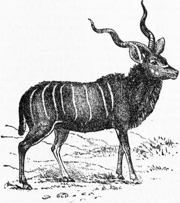
Male Kudu.
KUENEN, ABRAHAM (1828-1891), Dutch Protestant theologian, the son of an apothecary, was born on the 16th of September 1828, at Haarlem, North Holland. On his father’s death it became necessary for him to leave school and take a humble place in the business. By the generosity of friends he was educated at the gymnasium at Haarlem and afterwards at the university of Leiden. He studied theology, and won his doctor’s degree by an edition of thirty-four chapters of Genesis from the Arabic version of the Samaritan Pentateuch. In 1853 he became professor extraordinarius of theology at Leiden, and in 1855 full professor. He married a daughter of W. Muurling, one of the founders of the Gröningen school, which made the first pronounced breach with Calvinistic theology in the Reformed Church of Holland. Kuenen himself soon became one of the main supports of the modern theology, of which J. N. Scholten (1811-1885) and Karel Willem Opzoomer (b. 1821) were the chief founders, and of which Leiden became the headquarters. His first great work, an historico-critical introduction to the Old Testament, Historisch-kritisch onderzoek naar het onstaan en de verzameling van de boeken des Ouden Verbonds (3 vols., 1861-1865; 2nd ed., 1885-1893; German by T. Weber and C. T. Müller, 1885-1894), followed the lines of the dominant school of Heinrich Ewald. But before long he came under the influence of J. W. Colenso, and learned to regard the prophetic narrative of Genesis, Exodus, and Numbers as older than what was by the Germans denominated Grundschrift (“Book of Origins”). In 1869-1870 he published his book on the religion of Israel, De godsdienst van Israël tot den ondergang van der Joodschen Staat (Eng. trans., 1874-1875). This was followed in 1875 by a study of Hebrew prophecy, De profeten en de profetie onder Israel (Eng. trans., 1877), largely polemical in its scope, and specially directed against those who rest theological dogmas on the fulfilment of prophecy. In 1882 Kuenen went to England to deliver a course of Hibbert lectures, National Religions and Universal Religion; in the following year he presided at the congress of Orientalists held at Leiden. In 1886 his volume on the Hexateuch was published in England. He died at Leiden on the 10th of December 1891.
Kuenen was also the author of many articles, papers and reviews; a series on the Hexateuch, which appeared in the Theologisch Tijdschrift, of which in 1866 he became joint editor, is one of the finest products of modern criticism. His collected works were translated into German and published by K. Budde in 1894. Several of his works have been translated into English by Philip Wicksteed. See the article in Herzog-Hauck, Realencyklopädie.
KUEN-LUN, or Kwen-Lun, a term used to designate generally the mountain ranges which run along the northern edge of the great Tibetan plateau in Central Asia. In a wider application it means the succession of ranges which extend from the Pamirs on the W. to 113° E., until it strikes against or merges in the steep escarpments of the S.E. flank of the Mongolian plateau. In the narrower acceptation it applies only to those ranges which part the desert of Takla-makan on the N. from the Tibetan plateau on the S. between the Pamirs and the transverse glen of the Kara-muren, that is, nearly to the longitude of the town of Cherchen (about 85½° E.). Although the use of the name is thus restricted in geographical usage, the mountain system so designated does, as a fact, extend eastwards as far as the great depression of Tsaidam (say 95° E.), though it is uncertain whether its direct orographical continuation eastwards is to be identified with the Astin-tagh, or, as F. Grenard and K. Bogdanovich believe—and with them Sven Hedin is inclined to agree—with the parallel ranges of Kalta-alaghan and Arka-tagh, which lie S. of the Astin-tagh. At any rate the Astin-tagh, whether it is the principal continuation of the Kuen-lun or only a subsidiary flanking system, is itself the westward continuation of the Nan-shan or Southern Mountains, which reach down far into China (to 113° E.).
Taken in its widest meaning, the Kuen-lun Mountains thus stretch in a wavy line for nearly 2500 m. from E. to W., and while in the W. their constituent ranges are folded and squeezed by lateral compression into a breadth of some 150-200 m., their summits being forced up to correspondingly higher altitudes, in the E. they spread out to a breadth of some 600 m., the ranges being in that quarter less folded, and consequently both flatter and lower. In the tectonic structure of Asia the Kuen-lun forms, as it were, the backbone of the continent. In point of age it is very much older than either the Himalayas to the S. or the Tian-shan to the N. But although the crests of its component ranges reach altitudes of 21,500 to 22,000 ft., they are not as a rule overtopped by individual peaks of commanding and towering elevation, as the Himalayas are, but run on the whole tolerably uniform and relatively at little greater altitude than the lofty valleys which separate them one from another. It is a strikingly marked characteristic of the northern edge of the Tibetan plateau that its outermost border-range (e.g. Western Kuen-lun and Astin-tagh) is throughout double; and this “twinning” of the mountain-ranges, as also of the intermont lake-basins among the Kuen-lun ranges, is a peculiar feature of the Tibetan plateau.
The supreme orographic importance of this great Central Asian mountain system was recognized in a fashion even by the geographers of ancient Greece. They used to suppose that an immense range of mountains crossed Asia from west to east on the parallel of the island of Rhodes, extending through Asia Minor, the Kurdish highlands, the N. of Persia, the N. of Bactria (Afghanistan), the Hindu-kush, and so on into China. This long range they supposed to separate the waters which flow N. to the Arctic from those which flow S. to the Indian Ocean. K. Ritter (Asien, ii.) was the first of modern geographers to recognize the true character of the Kuen-lun as a border range of the Tibetan plateau; and Baron von Richthofen (China, i. 1876) still further defined and accentuated the conception of the system by representing it as a complex arrangement of several parallel ranges, running in wavy lines from the Pamirs (76° E.) eastwards to 118° E. But though von Richthofen’s general conception of the Kuen-lun system was broadly sound and in accordance with facts, the details both of his description and of that of his pupil Wegener1 require now very considerable revision, and need even to be in part recast, as a consequence of explorations and investigations made since they wrote by, amongst others, the Russian explorers N. M. Przhevalsky, M. V. Pyevtsov, V. I. Roboroysky, P. K. Kozlov, K. Bogdanovich, V. A. Obruchev, and (?) Skassi; by the Englishmen A. D. Carey, A. Dalgleish, St G. R. Littledale, H. Bower, H. H. P. Deasy and M. S. Wellby; by the American W. W. Rockhill; the Frenchmen J. L. Dutreuil de Rhins, F. Grenard, P. G. Bonvalot and Prince Henri d’Orléans; by the Hungarians L. von Loczy and Count Szechényi; and above all by the Swede Sven Hedin.
Western Kuen-lun.—On the east the Pamir highlands are fenced off from the East Turkestan lowlands by the double border-ridge of Sarik-kol (the Sarik-kol range and the Muztagh or Kashgar range), which has its eastern foot down in the Tarim basin (4000-4500 ft.) and its western up on the Pamirs at 10,500 to 13,000 ft. above sea-level, while its own summits, e.g. the Muztagh-ata (25,780 ft.), shoot up far above the limits of perpetual snow. This double border-ridge is continued east of the meridian of Yarkand or Yarkent (77° E.) by a succession of twin ranges, all running, though under different names, from the W.N.W. to the E.S.E. According to the investigations of F. Stoliczka and K. Bogdanovich, the same fossils occur in both sets of border ranges, in the Sarik-kol and in their eastward continuations, e.g. corals, Stromatophorae, Bryozoa, Atrypa reticularis, A. latilinguis and A. aspera, Spirifer verneuili, &c., and these the latter geologist assigns to the Devonian epoch. These eastward continuations of the double border-range of the Pamirs are the constituent ranges of the Kuen-lun proper. The names given to them are the Kilian or Kiliang, the Khotan and the Keriya Mountains in the more northerly range and the Raskem or Raskan, the Sughet and the Ullugh-tagh Mountains in the more southerly range. Although they all decrease in altitude from west to east, they nevertheless reach elevations of 19,000 ft., with individual peaks ascending some 2000-2500 ft. higher. From the East Turkestan lowlands on the north the ascent is very steep, and the passes across both sets of ranges lie at great altitudes; for example, the pass of Sanju-davan in the lower range is 16,325 ft. above sea-level, and the Kyzyl-davan, farther east, is 16,900 ft., while the Sughet-davan in the higher range is 17,825 ft. The latter range is separated from the Karakorum Mountains by the deeply trenched gorge of the Raskem or Yarkand-darya, while the deep glen of the Kara-kash or Khotan-darya intervenes between the upper (Sughet Mountains) and the lower (Kilian Mountains) border-ranges. Altogether this western extremity of the Kuen-lun system is a very rugged mountainous region, a consequence partly of the intricacy of the flanking ranges and spurs, partly of the powerful lateral compression to which they have been subjected, and partly of the great and abrupt differences in vertical elevation between the crests of the ranges and the bottoms of the deep, narrow, rugged glens between them. In the broad orographical disposition of the ranges there is considerable similarity between north Tibet and west Persia, in that in both cases the ranges are crowded together in the west, but spread out wider as they advance towards the east. To the two principal ranges in this part of the system F. Grenard, who accompanied J. L. Dutreuil de Rhins on his journey in 1890-1895, gives the names the Altyn-tagh and Ustun-tagh, though he names no less than six parallel ranges altogether. Now as Altyn-tagh2 is an accepted, though in point of fact erroneous, name for Astin-tagh, it is clear that Grenard considers the main Kuen-lun ranges to be continued directly by the Astin-tagh.
From the transverse breach of the Keriya-darya (about 81½° E.) to that of the Kara-muren in the longitude of Cherchen (about 85½° E.) the parallel border-ranges of the Tibetan plateau trend to the E.N.E., and here occur in the lower or outer range the passes of Dalai-kurghan-art (14,290 ft.), Choka-davan, i.e. Littledale’s Chokur Pass (9530 ft.) and others at altitudes ranging from 8600 to 11,500 ft., while in the upper range are the At-to-davan (16,600 ft.), Yapkak-lik-davan (15,550 ft.), Sarshu-davan (15,680 ft.) and others not named at 16,590 and 17,300 ft.
Middle Kuen-lun.—Between the upper transverse glens of the Kara-muren (or Mitt River) and the Cherchen-darya stretches the short range of Tokuz-davan. From it, on the east side of the Cherchen-daryt, in about 86° E., the component ranges of the middle Kuen-lun begin to diverge and radiate outwards (i.e. to north and to south) like the fingers of the outspread human hand. And here at least four principal ranges or groups of ranges admit of being discriminated, namely the Astin-tagh, the Chimen-tagh, the Kalta-alaghan and the Arka-tagh, all belonging to the mountainous country which borders on the north the actual plateau region of Tibet. Although these several ranges, or systems of ranges, differ considerably in their orographical characteristics, the following description will apply generally to the entire region from the Astin-tagh southwards to the Arka-tagh. The broad features of the surface configuration are a series of nearly parallel mountain-ranges, running from W.S.W. E.N.E. to W.N.W. E.S.E., and separated by high intermont valleys, which are choked with disintegrated material and divided into a chequered pattern of self-contained, shallow lacustrine basins. As a rule the crests of the ranges are worn down by aerial denudation and have the general appearance of rounded domes. Hard rock (mostly granite and crystalline schists, with red sandstone in places) appears only in the transverse glens, which are often choked with their débris in the form either of gravel-and-shingle or loose blocks of stone or both. The flanks of the mountains are so deeply buried in disintegrated material that the difference in vertical altitude between the floors of the valleys and the summits of the ranges is comparatively small. But as each successive range, proceeding south, represents a higher step in the terraced ascent from the desert of Gobi to the plateau of Tibet, the ranges when viewed from the north frequently appear like veritable upstanding mountain ranges, and this appearance is accentuated by the general steepness of the ascent; whereas, when viewed on the other hand from the south, these several ranges, owing to their long and gentle slope in that direction, have the appearance of comparatively gentle swellings of the earth’s surface rather than of well-defined mountain ranges. As a rule, the streams flow alternately east and west down the intermont latitudinal valleys, until they break through some transverse glen in the range on the northern side of the valley. In the western parts of the system they mostly go to feed the Kara-muren or the Cherchen-darya, while farther east they flow down into some larger self-contained basin of internal drainage, such as the Achik-kol, the two lakes Kara-kol, or the Ghaz-kol, and even yet farther east make their way, some of them into the lakes of the Tsaidam depression or become lost in its sands or in those of the Kum-tagh desert on the north, or go to feed the headstreams of the great rivers, the Hwang-ho (Yellow River) and the Yangtsze-kiang (Blue River) in the south. It appears to be a rule that the rivers which eventually terminate in the deserts of Gobi and Takla-makan grow increasingly larger in magnitude from east to west. Another law appears to distinguish the hydrography of at any rate the great latitudinal valleys of the Arka-tagh and the Chimen valley (north of the Chimen-tagh): the streams flow close under the foot of the range that shuts in each individual valley on the north. But in respect of precipitation there is a very marked difference between the valleys of the north and those of the south. Whereas both the mountains and valleys of the Astin-tagh and of the Akato-tagh (the next large range to the Astin-tagh on the south) are arid and desolate in the extreme, smitten as it were with the desiccating breath of the desert, those of the Arka-tagh and beyond are supersaturated with moisture, so that, at any rate in summer, the surface is in many parts little better than a quaking quagmire. Throughout vegetation is scanty and faunal life poor in species, though in some respects certain of the species, e.g. wild yaks, wild asses (kulans), antelopes (orongo and others), marmots, hares and partridges exist locally in large numbers. The wild camel approaches the north outliers of the Astin-tagh, but rarely, if ever, ventures to enter their fastnesses. Bears, wolves, foxes, goats (kökmet), wild sheep (arkharis), lizards, earth-rats, and a small rodent (teshikan), with ravens, eagles, wild ducks and wild geese are the other varieties principally encountered. The vegetation consists almost entirely of scrubby bushes of several varieties, including tamarisks and wild briers, of reeds (kamish), and of grass on the yaylaks (pasture-grounds) of the middle ranges. On the Arka-tagh even the moss, the last surviving representative of the flora, disappears entirely. In the eastern Astin-tagh a variety of wild tea (chay, mountain tea) is used by the Mongols. Gold is obtained in very small quantities in a few places in the Astin-tagh and the Kalta-alaghan. The nomenclature of the numerous ranges in this part of the Kuen-lun is extremely confusing, owing to different travellers having applied the same name to different ranges and to different travellers have applied different names to what is probably often identically the same range. In this article the nomenclature adopted is that employed by the latest, and probably the most thorough, explorer of this part of Central Asia, namely, Sven Hedin. Nevertheless, owing to the fact that nearly all the longer and more important crossings of Tibet and its northern montane region have been made from north to south, or vice versa, that is, transversely across the ranges, and comparatively few from east to west along the intermont latitudinal valleys, the identifications between ranges in the east and ranges in the west are in more than one instance more or less doubtful.
The Astin-tagh, although it occupies a similar position to the twin ranges of the Western Kuen-lun, in that it forms the outermost escarpment or border-ridge on the north of the Tibetan plateau, would appear in the opinion of the most competent judges (e.g. Grenard, Bogdanovich, Sven Hedin, Przhevalsky), to be only a branch or subsidiary range of the main range of the Kuen-lun. It is not however a single, long, continuous chain, as it is shown, for example, on the map of the Russian general staff, but consists of two parallel main ranges, and in the east of three, and even to the N.E. of Tsaidam of four, parallel main ranges, flanked throughout by several subsidiary chains, spurs and offshoots. Beyond that it swells out into the vast massif of Anambaruin-ula, which is traversed by at least three minor parallel chains. But on the east of the Anambaruin-ula it once more contracts to two main ranges, the more southerly being that which Przhevalsky called the Humboldt Range (crossed by a pass at 13,200 ft.). This branch is probably continued in the range which overhangs the Koko-nor on the south, namely, the south Koko-nor Range. The northern branch merges eastwards into the Nan-shan or Southern Mountains.3 The passes in the Lower Astin-tagh range from altitudes of 10,150 to 10,700 ft., and in the Upper Astin-tagh at 11,770 to 15,680 ft. (Tash-davan), though one pass beside the Charkhlik-su is only 9660 ft. high. And as the relative altitudes of crest and pass remain approximately the same as in the Western Kuen-lun, it is evident how greatly the general elevation of the twin border ridge decreases towards the east. But there exists a striking difference between the crests of the Astin-tagh and those of the ranges which give rise to the gigantic ridge and furrow arrangement on the Tibetan plateau. “Here in the Astin-tagh the mountains, like those in the Kuruk-tagh,4 are indeed severely weathered, but they always consist, from base to summit, of hard rock, bare and barren, most frequently piled up in eccentric, rugged masses, denticulated, pinnacled crests and peaks. On the Tibetan plateau, on the other hand, most of the ranges are distinguished by their rounded outlines and soft consistency, and their striking poverty in hard rock, which in the best cases only crops out near the summits. There too disintegration has been to a remarkable extent operative. This gives rise to the great morphological difference, that in the former regions, the Astin-tagh and the Kuruk-tagh, the products of disintegration are almost always carried away by the wind, and so disappear; no matter how powerful or how active the disintegration may be, none of the loosened material ever succeeds either in gathering amongst the mountains or in accumulating at their foot. The climate is so arid, and precipitation so extremely rare, that the fine powdery material falls a helpless prey to the winds. On the other hand, the precipitation on the Tibetan plateau is so copious, and so uniformly distributed, that it is able to retain the loosened material in situ, and causes it to heap itself up in rounded masses on the flanks of the mountains that are its primitive source of origin, these projecting in great part like skeletons from the midst of their own ruins.”5 The twin ranges of the Astin-tagh are fairly equivalent in point of magnitude and regularity; but while the Lower Range, on the north, sensibly decreases in altitude towards the east, the Upper Range, on the south, maintains its general altitude in a remarkable way, and is gapped by steep, wild, deeply incised transverse glens directed towards the north, and generally fenced in by dark precipitous walls of rock. The great valley between the two is “cut up into a series of self-contained basins, each serving as the gathering ground of the brooks that run down off the adjacent mountains. Outside the lower end of each large transverse glen there is a scree of sedimentary matter. These screes are however very flat and their lower edges generally reach all the way down to the central part of the basin, which is occupied by an expanse of yellow clay, perfectly flat and fairly hard, as well as dry and barren, often cracked into polygonal cakes and drawn out in the direction of the long axis of the valley.... But though the great morphological features of this latitudinal valley forcibly recall the latitudinal valleys of Tibet, the climatic differences give rise to differences between the basins corresponding to the differences between the mountain-ranges themselves. For while the self-contained basins of Tibet generally possess a salt lake in the middle, into which brooks and streams of greater or less magnitude gather, often from very considerable distances, these self-contained basins of the Astin-tagh are very small in area, and it is extremely seldom that their central parts receive any water at all, only in fact after copious rain. These terminal lakes, or more accurately sedimentary plains, are therefore almost always dry.”6
The next parallel range on the south, the Akato-tagh, and the valley which separates it from the Astin-tagh, are equally arid and waterless. The valley, known by the general name of Kakir, meaning a “hard, dry, sterile expanse of clay,” is chequered with shallow self-contained basins of the usual type and has remarkably gentle slopes up to the mountains on both north and south. Its surface slopes from altitudes of 10,100 to 10,600 ft. in the west, where is the lake of Uzunshor (9650 ft.) to 9400 ft. in the east, in which direction it continues as far as the Anambaruin-ula (see below) and the plain or flat basin of Särtäng, a north extension of Tsaidam. This range of Akato-tagh, the Altun Range of Carey, is the same as that which on the map of the Russian general staff bears the name Chimen-tagh. Like the Astin-tagh it stretches towards the E.N.E., and, like it, appears to be built up of granite and schists, but its crest is greatly denuded, so that it is a mere crumbling skeleton protruding above the deep mantle of disintegrated material which masks its flanks. The slopes on both north and south are extremely gentle, but that on the south is eight to ten times as long as that on the north. In the east the range is mostly narrow, and dies away on the edge of the Tsaidam depression; but in the west it swells out into the lofty and imposing mass of the Ilve-chimen or Shia-manglay, which is capped with perpetual snow. This part of the range is crossed by the pass of Chopur-alik at an altitude of 16,160 ft., but farther east the passes lie at altitudes of 13,380 to 10,520 ft. The latitudinal valley that intervenes between the Akato-tagh and the next great range on the south, the Chimen-tagh, slopes for the most part eastwards, from 12,500 ft. down to the shallow salt lake of Ghaz-kol or Chimen-koli (9305 ft.). In the western part of this valley occurs the very important transverse water-divide of Gulcha-davan (14,150 ft.), which separates the basin of the Cherchen-darya that goes down into the Tarim basin from the area that drains down to the Ghaz-kol, which belongs to the Tsaidam depression. This, the Chimen valley, contains in places a good deal of drift-sand, which however is stationary in the mass and heaped up along the northern foot of the Chimen-tagh. Nevertheless the Akato-tagh is only of secondary importance in the general Kuen-lun system, being nothing more than a central ridge running along the broad Kakir valley that separates the Astin-tagh from the Chimen-tagh.
The latter range, the Chimen-tagh, is identical in its western parts with the Piazlik-tagh and in the east must be equated with the Tsaidam chain of Przhevalsky; and it is probably continued westwards by the range which the Russian explorers call the Moscow Range or the Achik-tagh, running north of the Achik-kol and, according to Przhevalsky, connecting on the west with the Tokuz-davan. The Chimen-tagh rises into imposing summits, some rounded, some pyramidal in outline, which are capped with snow, though the snow melts in summer. This range acts as a “breakwater” to the clouds, arresting and condensing the moisture which is carried northwards by the south winds. Hence its slopes are not so arid as those of the Akato-tagh and the Astin-tagh. Snow falls all the year round on the Chimen-tagh, even in July, and water is abundant everywhere. The southern slope of the range is gentle but short, the northern slope long and steep. Grass is able to grow, and animal life is more abundant. The range is crossed by passes at 13,970, 13,230 and 13,760 ft., and the Piazlik-tagh by a pass at an altitude of 13,640 ft.
The next important range, still going south, is the Kalta-alaghan, Carey’s Chimen-tagh Range, Przhevalsky’s Columbus Range and the range which is variously designated (e.g. by Pyevtsov) as the Ambal-ashkan, Kalga-lagan and Ara-tagh. This last is, however, properly the name of a short secondary range which rises along the middle (ara = middle) of the valley between the Chimen-tagh and the Kalta-alaghan. Not only is it of lower elevation than them both, but it dies away towards the west, the valleys on each side of it meeting round its extremity to form one broad, open valley, with an altitude of 11,790 to 13,725 ft. The Ara-tagh is crossed by a pass at an altitude of 14,345 ft. In the Kalta-alaghan, which is the culminating range of this part of the Kuen-lun, and is overtopped by towering, snow-clad peaks, the passes climb to considerably higher altitudes, namely, 14,560, 14,470, 14,430 and 14,190 ft., while the pass of Avraz-davan ascends to 15,700 ft. This range appears to be linked on to the Tokuz-davan by the Muzluk-tagh, in which there are passes at 16,870 and 15,450 ft. It is possible however that the Muzluk-tagh belongs more intimately to the Chimen-tagh system, that is, to the Moscow or Achik-kol ranges, Indeed Bogdanovich considers that the Tokuz-davan, the Muzluk-tagh, the Moscow Range and the Chimen-tagh form one single closely connected chain, in which he also places Przhevalsky’s isolated peak of Mount Kreml (15,055 ft.). Sven Hedin, whilst agreeing that this may possibly be the true conception, inclines to the view that the Achik-kol Range dies away towards the E., and that the Chimen-tagh and the Kalta-alaghan merge westwards into the border-ranges that lie north of the Muzluk-tagh and the Tokuz-davan. Unlike most of the other parallel ranges of N. Tibet, the Kalta-alaghan does not decrease, but it increases in elevation towards the east, where, like the Chimen-tagh, it abuts upon and merges in the ranges that border Tsaidam on the south.
Immediately south of the Kalta-alaghan comes a relatively deep depression, the Kum-kol valley, forming a very well-marked feature in the physical conformation of this region. It is crossed transversely by a water-divide which separates the basin of the twin-lakes of Kum-kol (12,700 ft.) from the basin of Tsaidam, some 3500 ft. lower. The floor of the valley consequently slopes away in both directions, like the Chimen valley between the Akato-tagh and the Chimen-tagh; and in so far as it slopes westwards towards the Kum-kol lakes it differs from nearly all the other great latitudinal valleys that run parallel with it, because they slope generally towards the east. Not far from the Kum-kol lakes there is a drift-sand area, though the dunes are stationary. The upper lake of Kum-kol (Chon-kum-kol) (12,730 ft.), which contains fresh water, is of small area (8 sq. m.) and in depth nowhere exceeds 13 ft.; but the lower lake (Ayak-kum-kol) (12,685 ft.), which is salt, is much bigger (283 sq. m.) and goes down to depths of 64 and 79 ft. Farther west, lying between the Muzluk-tagh and the Arka-tagh, is the lake of Achik-kol (13,940 ft.), 16½ m. broad and 50 m. in circuit.
The next great parallel range is the lofty and imposing Arka-tagh, the Przhevalsky Range of the Russian geographers, which has its eastward continuations in the Marco Polo Range (general altitude 15,750-16,250 ft.) and Gurbu-naiji Mountains of Przhevalsky. The Arka-tagh7 is the true backbone of the Kuen-lun system, and in Central Asia is exceeded in elevation only by the Tang-la, a long way farther south, this last being probably an eastern wing of the Karakorum Mountains of the Pamirs region. At the same time the Arka-tagh is the actual border-range of the Tibetan plateau properly so-called; to the south of it none of the long succession of lofty parallel ranges which ridge the Tibetan highlands seems to have any connexion with the Kuen-lun system. Of great length, the Arka-tagh, which is a mountain-system rather than a range, varies greatly in configuration in different parts, sometimes exhibiting a sharply defined main crest, with several lower flanking ranges, and sometimes consisting of numerous parallel crests of nearly uniform altitude. Amongst these it is possible to distinguish in the middle of the system four predominant ranges, of which the second from the north is probably the principal range, though the fourth is the highest. The passes across the first range (north) lie at altitudes of 15,675, 16,420, 17,320 and 18,300 ft.; across the second at 16,830, 17,020, 17,070 and 17,220 ft.; across the third at 16,800, 16,660, 17,065, 17,830 and 17,880 ft.; and across the fourth at 16,540, 16,765, 16,780, 18,100 and 18,110 ft. The crests of the ranges lie comparatively little higher than the valleys which separate them, the altitudes in the latter running at 14,940 to 16,700 ft., if not higher, and being only 500 to 1000 ft. lower than the crests of the accompanying ranges. The Arka-tagh ranges do not culminate in lofty jagged, pinnacled peaks, but in broad rounded, flattened domes, a characteristic feature of the system throughout. These Arka-tagh mountains are built up, at all events superficially, of sand and powdery, finely sifted disintegrated material. Where the hard rock does crop out on the surface, it is so excessively weathered as to be with difficulty recognized as rock at all. The culminating summits of the ranges generally present the appearance of a flat, rounded swelling, and when they are crowned with glaciers, as many of them are, these shape themselves into what may be described as a mantle, a breast-plate, or a flat cap, from which lappets and fringes project at intervals; nowhere do there exist any of the long, narrow, winding glacier tongues which are so characteristic of the Alps of Europe. But not the slightest indication has been discovered that these mountains were ever panoplied with ice. The process of disintegration and levelling down has reached such an advanced stage that, if ever there did exist evidences of former glaciation, they have now become entirely obliterated, even to the complete pulverization of the erratic blocks, supposing there were any. The view that meets the eye southwards from the heights of the Kalta-alaghan is the picture of a chaos of mountain chains, ridges, crests, peaks, spurs, detached masses, in fact, montane conformations of every possible description and in every possible arrangement. Immediately north of the Arka-tagh the country is studded with three or four exceptionally conspicuous and imposing detached mountain masses, all capped with snow and some of them carrying small glaciers. Amongst them are Shapka Monomakha or the Monk’s Cap; the Chulak-akkan, which may however be only Shapka Monomakha seen from a different point of view; Tömürlik-tagh8 (i.e. the Iron Mountain); and farther west, Ullugh-muz-tagh, which, according to Grenard, reaches an altitude of 24,140 ft. But the relations in which these detached mountain-masses stand to one another and to the Arka-tagh behind them have not yet been elucidated. In the vicinity of the Ullugh-muz-tagh there exist numerous indications of former volcanic activity, the eminences and summits frequently being capped with tuff, and smaller fragments of tuff are scattered over other parts of the Arka-tagh ranges.
The next succeeding parallel range, the Koko-shili, which is continued eastwards by the Bayan-khara-ula, between the upper headstreams of the Hwang-ho or Yellow River and the Yangtsze-kiang, belongs orographically to the plateau of Tibet.
The succession of ranges which follow one another from the deserts of Takla-makan and Gobi up to the plateau proper of Tibet rise in steps or terraces, each range being higher than the range to the north of it and lower than the range to the south of it. The difference in altitude between the lowest, most northerly range, the Lower Astin-tagh, and the most southerly of the Arka-tagh ranges amounts to nearly 7500 ft. With one exception, namely the climb out of the Kum-kol valley to the Arka-tagh, the first three steps are individually the biggest; whereas the Upper Astin-tagh exceeds the Lower Astin-tagh by an altitude of some 1350 ft., it is itself exceeded by the Akato-tagh to the extent of 1760 ft. There is also a considerable rise of 880 ft. from the Akato-tagh to the Chimen-tagh. But between the Chimen-tagh, the Ara-tagh and the Kalta-alaghan there is comparatively little difference in point of elevation, namely, 730 ft. in all. The biggest ascent is that from the Kalta-alaghan to the Arka-tagh, namely, nearly 1850 ft. The ranges of the Arka-tagh, again, run at pretty nearly the same absolute general altitudes, namely, 16,470 to 17,260 ft. When the altitudes of the intermont latitudinal valleys are compared, the significance orographically of the Chimen valley and of the Kum-kol valley is strikingly emphasized. Both are much more deeply excavated than all the other latitudinal valleys that run parallel to them, the Chimen valley being 875 ft. above the valley to the north of it, but no less than 2235 ft. below the valley to the south of it. The case of the Kum-kol valley is altogether exceptional, for it lies not higher, but 680 ft. lower, than the valley to the north of it, and consequently the climb up out of it to the first (on north) of the Arka-tagh valleys amounts to no less than 2900 ft. Hence these ten parallel ranges of the middle Kuen-lun system may be grouped in three divisions—(1) the more strictly border ranges of the Upper and Lower Astin-tagh and the Akato-tagh; (2) the three ranges of Chimen-tagh, Ara-tagh and Kalta-alaghan, which may be considered as forming a transitional system between the foregoing and the third division; (3) the Arka-tagh, which constitute the elevated rampart of the Tibetan plateau proper.
(J. T. Be.)
The Nan-shan Highlands overlook Tsaidam on the N.E. They embrace a region 380 m. long and 260 m. wide, entirely occupied with parallel mountain ranges all running from the N.W. to the S.E. Broad, flat, longitudinal valleys, at altitudes of 12,000 to 14,000 ft. (9000 to 10,000 at the south-western border) and dotted with lakes (Koko-nor, 9970 ft.; Khara-nor, 13,285 ft.), fill up the space between these mountain ranges. In the S.E. the Nan-shan highlands abut upon the highlands of the Chinese province of Kan-suh, and near the great northward bend of the Hwang-ho they meet the escarpments by which the Great Khingan and the In-shan ranges are continued, and by which the Mongolian plateau steps down to the lowlands of China. On the N.E. the Nan-shan highlands have their foot on the Mongolian plateau (average altitude, 4000 ft.), i.e. in the Ala-shan. On the N.W. they are fringed by a border range, the Da-sue-shan, a continuation of the Astin-tagh, which rises to 12,200-13,000 ft. in its passes, and is pierced by several rivers flowing west to Lake Khala-chi or Khara-nor. This border-range, which continues on to the 97th meridian, separates the Nan-shan range from the Pe-shan range.
On the S.W. the Nan-shan mountains consist of short irregular chains, separated by broad plains, dotted with lakes, which differ but slightly in altitude from Tsaidam (8800-9000 ft.). Next a succession of narrow ranges intervene between this lower border terrace and the higher terrace (12,000-13,500 ft.). The first mountain range on this higher terrace is Ritter’s range, covered in part with extensive snow-fields. The passes at both ends of this snow-clad massif lie at altitudes of 15,990 ft. and 14,680 ft. The next range is Humboldt or Ama-surgu range, which runs N.W. to S.E. from the Astin-tagh to about 38° N., and is perhaps continued by the southern Kuku (Koko)-nor range, which strikes the Hwang-ho with an elevation of 7440 ft. It includes, in fact, several other parallel ranges—e.g. the Mushketov, Semenov, Suess, Alexander III., Bain-sarlyk—the mutual relations of which are, however, not yet definitely settled.
Small lateral chains of mountains, rising some 2000 ft. above the general level of that plateau, connect the central Nan-shan with the next parallel ranges, namely, those of the eastern Nan-shan. The mutual relations of the latter, as well as the names of the several constituent chains, are equally unsettled. Thus, one of them is named indiscriminately Nan-shan, Richthofen Range and Momo-shan. In fact, the region is dominated by three ranges of nearly equal altitude, all lifting many of their peaks above the snow-line. Finally, there is a range of mountains, about 10,000 ft. high, named Lung-shan by Obruchev, which borders the Kan-chow and Lian-chow valley on the N.E., and belongs to the Nan-shan system. But the string of oases in Kan-suh province, which stretches between the towns named, lies on the lower level of the Mongolian plateau (4000 to 5000 ft.), so that the Lung-shan ought possibly to be regarded as a continuation of the Pe-shan mountains of the Gobi.
Generally speaking, the Nan-shan highlands are a region raised 12,000 to 14,000 ft. above the sea, and intersected by wild, stony and partly snow-clad mountains, towering another 4000 to 7000 ft. above its surface, and arranged in narrow parallel chains all running N.W. to S.E. The chains of mountains are severally from 8 to 17 m. wide, seldom as much as 35, while the broad, flat valleys between them attain widths of 20 to 27 m. As a rule the passes are at an altitude of 12,000 to 14,000 ft., and the peaks reach 18,000 to 20,000 ft. in the western portion of the highlands, while in the eastern portion they may be about 2000 ft. lower. The glaciers also attain a greater development in the western portion of the Nan-shan, but the valleys are dry, and the slopes of both the mountains and the valleys, furrowed by deep ravines, are devoid of vegetation. Good pasture grounds are only found near the streams. The soil is dry gravel and clay, upon which bushes of Ephedra, Nitraria and Salsolaceae grow sparsely. In the north-eastern Nan-shan, on the contrary, a stream runs through each gorge, and both the mountain slopes and the bottoms of the valleys are covered with vegetation. Forests of conifers (Picea obovata) and deciduous trees—Przhevalsky’s poplar, birch, mountain ash, &c., and a variety of bushes—are common everywhere. Higher up, in the picturesque gorges, grow rhododendrons, willows, Potentilla fruticosa, Spriaeae, Lonicereae, &c., and the rains must evidently be more copious and better distributed. In the central Nan-shan it is only the north-eastern slopes that bear forests. In the south, where the Nan-shan enters Kan-suh province, extensive accumulations of loess make their appearance, and it is only the northern slopes of the hills that are clothed with trees.
(P. A. K.)
Authorities.—An enumeration of the works published before 1890, and a map of itineraries, will be found in Wegener’s Versuch einer Orographie des Kuen-lun (Marburg, 1891), but his map is only approximately correct. Of the books published since 1890 the most important are Sven Hedin’s Scientific Results of a Journey in Central Asia, 1899-1902 (Stockholm, 1905-1907, 6 vols.), with an elaborate atlas and a general map of Tibet on the scale of 1 : 1,000,000; H. H. P. Deasy’s In Tibet and Chinese Turkestan (London, 1901), with a good map; F. Grenard’s vol. (iii.) of J. L. Dutreuil de Rhins’s Mission scientifique dans la haute Asie, 1890-1895 (n.p., 1897), also with a very useful map; W. W. Rockhill’s Diary of a Journey through Mongolia and Tibet in 1891 and 1892 (Washington, 1894); M. S. Wellby’s Through Unknown Tibet (London, 1898); P. G. Bonvalot’s De Paris au Tonkin à travers le Tibet inconnu (Paris, 1892); St G. R. Littledale’s “A Journey across Tibet,” in Geog. Journal (May 1896); H. Bower’s Diary of a Journey across Tibet (London, 1894); the Izvestia of the Russian Geog. Soc. and Geog. Journal, both passim.
1 In “Orographie des Kwen-lun,” in Zeitschrift der Gesellschaft für Erdkunde zu Berlin (1891).
2 It is used, for instance, on the map of “Inner-Asien” (No. 62) of Stieler’s Hand-atlas (ed. 1905) and in the Atlas of the Russian General Staff. Etymologically the correct form is Astin-tagh or Astun-tagh, meaning the Lower or Nearer Mountains. Ustun-tagh, which appears on Stieler’s map as an alternative name for Altyn-tagh, means Higher or Farther Mountains, and though not used locally of any specific range, would be appropriately employed to designate the higher and more southerly of the twin border-ranges of the Tibetan plateau.
3 The Northern Mountains are the Pe-shan in the desert of Gobi (see Gobi).
4 On the opposite or north side of the desert of Lop (desert of Gobi).
5 Sven Hedin, Scientific Results, iii. 308.
6 Ibid. 310-311.
7 This is the correct form, Arka-tagh meaning the Farther or Remoter Mountains. The form Akka-tagh is incorrect.
8 The form Tumenlik-tagh is erroneous.
KUFA, a Moslem city, situated on the shore of the Hindieh canal, about 4 m. E. by N. of Nejef (32° 4´ N., 44° 20´ E.), was founded by the Arabs after the battle of Kadesiya in A.D. 638 as one of the two capitals of the new territory of Irak, the whole country being divided into the sawads, or districts, of Basra and Kufa. The caliph ‘Ali made it his residence and the capital of his caliphate. After the removal of the capital to Bagdad, in the middle of the following century, Kufa lost its importance and began to fall into decay. At the beginning of the 19th century, travellers reported extensive and important ruins as marking the ancient site. Since that time the ruins have served as quarries for bricks for the building of Nejef, and at the present time little remains but holes in the ground, representing excavations for bricks, with broken fragments of brick and glass strewn over a considerable area. A mosque still stands on the spot where ‘Ali is reputed to have worshipped. (For history see Caliphate.)
KUHN, FRANZ FELIX ADALBERT (1812-1881), German philologist and folklorist, was born at Königsberg in Neumark on the 19th of November 1812. From 1841 he was connected with the Köllnisches Gymnasium at Berlin, of which he was appointed director in 1870. He died at Berlin on the 5th of May 1881. Kuhn was the founder of a new school of comparative mythology, based upon comparative philology. Inspired by Grimm’s Deutsche Mythologie, he first devoted himself to German stories and legends, and published Märkische Sagen und Märchen (1842), Norddeutsche Sagen, Märchen und Gebräuche (1848), and Sagen, Gebräuche und Märchen aus Westfalen (1859). But it is on his researches into the language and history of the Indo-Germanic peoples as a whole that his reputation is founded. His chief works in this connexion are: Zur ältesten Geschichte der Indogermanischen Völker (1845), in which he endeavoured to give an account of the earliest civilization of the Indo-Germanic peoples before their separation into different families, by comparing and analysing the original meaning of the words and stems common to the different languages; Die Herabkunft des Feuers und des Göttertranks (1859; new ed. by E. Kuhn, under title of Mythologische Studien, 1886); and Über Entwicklungsstufen der Mythenbildung (1873), in which he maintained that the origin of myths was to be looked for in the domain of language, and that their most essential factors were polyonymy and homonymy. The Zeitschrift für vergleichende Sprachforschung auf dem Gebiete der Indogermanischen Sprachen, with which he was intimately connected, is the standard periodical on the subject.
See obituary notice by C. Bruchmann in Bursian’s Biographisches Jahrbuch (1881) and J. Schmidt in the above Zeitschrift, xxvi. n.s. 6.
KÜHNE, WILLY (1837-1900), German physiologist, was born at Hamburg on the 28th of March 1837. After attending the gymnasium at Lüneburg, he went to Göttingen, where his master in chemistry was F. Wöhler and in physiology R. Wagner. Having graduated in 1856, he studied under various famous physiologists, including E. Du Bois-Reymond at Berlin, Claude Bernard in Paris, and K. F. W. Ludwig and E. W. Brücke in Vienna. At the end of 1863 he was put in charge of the chemical department of the pathological laboratory at Berlin, under R. von Virchow; in 1868 he was appointed professor of physiology at Amsterdam; and in 1871 he was chosen to succeed H. von Helmholtz in the same capacity at Heidelberg, where he died on the 10th of June 1900. His original work falls into two main groups—the physiology of muscle and nerve, which occupied the earlier years of his life, and the chemistry of digestion, which he began to investigate while at Berlin with Virchow. He was also known for his researches on vision and the chemical changes occurring in the retina under the influence of light. The visual purple, described by Franz Boll in 1876, he attempted to make the basis of a photochemical theory of vision, but though he was able to establish its importance in connexion with vision in light of low intensity, its absence from the retinal area of most distinct vision detracted from the completeness of the theory and precluded its general acceptance.
KUKA, or Kukawa, a town of Bornu, a Mahommedan state of the central Sudan, incorporated in the British protectorate of Nigeria (see Bornu). Kuka is situated in 12° 55´ N. and 13° 34´ E., 4½ m. from the western shores of Lake Chad, in the midst of an extensive plain. It is the headquarters of the British administration in Bornu, and was formerly the residence of the native sovereign, who in Bornu bears the title of shehu.
The modern town of Kuka was founded c. 1810 by Sheikh Mahommed al Amin al Kanemi, the deliverer of Bornu from the Fula invaders. It is supposed to have received its name from the kuka or monkey bread tree (Adansonia digitata), of which there are extensive plantations in the neighbourhood. Kuka or Kaoukaou was a common name in the Sudan in the middle ages. The number of towns of this name gave occasion for much geographical confusion, but Idrisi writing in the 12th century, and Ibn Khaldun in the 14th century, both mention two important towns called Kaou Kaou, of which one would seem to have occupied a position very near to that of the modern Kuka. Ibn Khaldun speaks of it as the capital of Bornu and as situated on the meridian of Tripoli. In 1840 the present town was laid waste by Mahommed Sherif, the sultan of Wadai; and when it was restored by Sheikh Omar he built two towns separated by more than half a mile of open country, each town being surrounded by walls of white clay. It was probably owing to there being two towns that the plural Kukawa became the ordinary designation of the town in Kano and throughout the Sudan, though the inhabitants used the singular Kuka. The town became wealthy and populous (containing some 60,000 inhabitants), being a centre for caravans to Tripoli and a stopping-place of pilgrims from the Hausa countries going across Africa to Mecca. The chief building was the great palace of the sheikh. Between 1823 and 1872 Kuka was visited by several English and German travellers. In 1893 Bornu was seized by the ex-slave Rabah (q.v.), an adventurer from the Bahr-el-Ghazal, who chose a new capital, Dikwa, Kuka falling into complete decay. The town was found in ruins in 1902 by the British expedition which replaced on the throne of Bornu a descendant of the ancient rulers. In the same year the rebuilding of Kuka was begun and the town speedily regained part of its former importance. It is now one of the principal British stations of eastern Bornu. Owing, however, to the increasing importance of Maidugari, a town 80 m. S.S.W. of Kuka, the court of the shehu was removed thither in 1908.
For an account of Kuka before its destruction by Rabah, see the Travels of Heinrich Barth (new ed., London, 1890); and Sahara und Sudan, by Gustav Nachtigal (Berlin, 1879), i. 581-748.
KU KLUX KLAN, the name of an American secret association of Southern whites united for self-protection and to oppose the Reconstruction measures of the United States Congress, 1865-1876. The name is generally applied not only to the order of Ku Klux Klan, but to other similar societies that existed at the same time, such as the Knights of the White Camelia, a larger order than the Klan; the White Brotherhood; the White League; Pale Faces; Constitutional Union Guards; Black Cavalry; White Rose; The ’76 Association; and hundreds of smaller societies that sprang up in the South after the Civil War. The object was to protect the whites during the disorders that followed the Civil War, and to oppose the policy of the North towards the South, and the result of the whole movement was a more or less successful revolution against the Reconstruction and an overthrow of the governments based on negro suffrage. It may be compared in some degree to such European societies as the Carbonara, Young Italy, the Tugendbund, the Confréries of France, the Freemasons in Catholic countries, and the Vehmgericht.
The most important orders were the Ku Klux Klan and the Knights of the White Camelia. The former began in 1865 in Pulaski, Tennessee, as a social club of young men. It had an absurd ritual and a strange uniform. The members accidentally discovered that the fear of it had a great influence over the lawless but superstitious blacks, and soon the club expanded into a great federation of regulators, absorbing numerous local bodies that had been formed in the absence of civil law and partaking of the nature of the old English neighbourhood police and the ante-bellum slave patrol. The White Camelia was formed in 1867 in Louisiana and rapidly spread over the states of the late Confederacy. The period of organization and development of the Ku Klux movement was from 1865 to 1868; the period of greatest activity was from 1868 to 1870, after which came the decline.
The various causes assigned for the origin and development of this movement were: the absence of stable government in the South for several years after the Civil War; the corrupt and tyrannical rule of the alien, renegade and negro, and the belief that it was supported by the Federal troops which controlled elections and legislative bodies; the disfranchisement of whites; the spread of ideas of social and political equality among the negroes; fear of negro insurrections; the arming of negro militia and the disarming of the whites; outrages upon white women by black men; the influence of Northern adventurers in the Freedmen’s Bureau (q.v.) and the Union League (q.v.) in alienating the races; the humiliation of Confederate soldiers after they had been paroled—in general, the insecurity felt by Southern whites during the decade after the collapse of the Confederacy.
In organization the Klan was modelled after the Federal Union. Its Prescript or constitution, adopted in 1867, and revised in 1868, provided for the following organization: The entire South was the Invisible Empire under a Grand Wizard, General N. B. Forrest; each state was a Realm under a Grand Dragon; several counties formed a Dominion under a Grand Titan; each county was a Province under a Grand Giant; the smallest division being a Den under a Grand Cyclops. The staff officers bore similar titles, relics of the time when the order existed only for amusement: Genii, Hydras, Furies, Goblins, Night Hawks, Magi, Monks and Turks. The private members were called Ghouls. The Klan was twice reorganized, in 1867 and in 1868, each time being more centralized; in 1869 the central organization was disbanded and the order then gradually declined. The White Camelia with a similar history had a similar organization, without the queer titles. Its members were called Brothers and Knights, and its officials Commanders.
The constitutions and rituals of these secret orders have declarations of principles, of which the following are characteristic: to protect and succour the weak and unfortunate, especially the widows and orphans of Confederate soldiers; to protect members of the white race in life, honour and property from the encroachments of the blacks; to oppose the Radical Republican party and the Union League; to defend constitutional liberty, to prevent usurpation, emancipate the whites, maintain peace and order, the laws of God, the principles of 1776, and the political and social supremacy of the white race—in short, to oppose African influence in government and society, and to prevent any intermingling of the races.
During the Reconstruction the people of the South were divided thus: nearly all native whites (the most prominent of whom were disfranchised) on one side irrespective of former political faith, and on the other side the ex-slaves organized and led by a few native and Northern whites called respectively scalawags and carpet-baggers, who were supported by the United States government and who controlled the Southern state governments. The Ku Klux movement in its wider aspects was the effort of the first class to destroy the control of the second class. To control the negro the Klan played upon his superstitious fears by having night patrols, parades and drills of silent horsemen covered with white sheets, carrying skulls with coals of fire for eyes, sacks of bones to rattle, and wearing hideous masks. In calling upon dangerous blacks at night they pretended to be the spirits of dead Confederates, “just from Hell,” and to quench their thirst would pretend to drink gallons of water which was poured into rubber sacks concealed under their robes. Mysterious signs and warnings were sent to disorderly negro politicians. The whites who were responsible for the conduct of the blacks were warned or driven away by social and business ostracism or by violence. Nearly all southern whites (except “scalawags”), whether members of the secret societies or not, in some way took part in the Ku Klux movement. As the work of the societies succeeded, they gradually passed out of existence. In some communities they fell into the control of violent men and became simply bands of outlaws, dangerous even to the former members; and the anarchical aspects of the movement excited the North to vigorous condemnation.1 The United States Congress in 1871-1872 enacted a series of “Force Laws” intended to break up the secret societies and to control the Southern elections. Several hundred arrests were made, and a few convictions were secured. The elections were controlled for a few years, and violence was checked, but the Ku Klux movement went on until it accomplished its object by giving protection to the whites, reducing the blacks to order, replacing the whites in control of society and state, expelling the worst of the carpet-baggers and scalawags, and nullifying those laws of Congress which had resulted in placing the Southern whites under the control of a party composed principally of ex-slaves.
Authorities.—J. C. Lester and D. L. Wilson, Ku Klux Klan (New York, 1905); W. L. Fleming, Civil War and Reconstruction in Alabama (New York, 1905), and Documentary History of Reconstruction (Cleveland, 1906); J. W. Garner, Reconstruction in Mississippi (New York, 1901); W. G. Brown, Lower South in American History (New York, 1901); J. M. Beard, Ku Klux Sketches (Philadelphia, 1876); J. W. Burgess, Reconstruction and the Constitution (New York, 1901).
(W. L. F.)
1 The judgment of the historian William Garrott Brown, himself a Southerner, is worth quoting: “That violence was often used cannot be denied. Negroes were often whipped, and so were carpet-baggers. The incidents related in such stories as Tourgée’s A Fool’s Errand all have their counterparts in the testimony before congressional committees and courts of law. In some cases, after repeated warnings, men were dragged from their beds and slain by persons in disguise, and the courts were unable to find or to convict the murderers. Survivors of the orders affirm that such work was done in most cases by persons not connected with them or acting under their authority. It is impossible to prove or disprove their statements. When such outrages were committed, not on worthless adventurers, who had no station in the Northern communities from which they came, but on cultivated persons who had gone South from genuinely philanthropic motives—no matter how unwisely or tactlessly they went about their work—the natural effect was to horrify and enrage the North.”
KUKU KHOTO (Chinese Kwei-hwa), a city of the Chinese province of Shan-si, situated to the north of the Great Wall, in 40° 50´ N. and 111° 45´ E., about 160 m. W. of Kalgan. It lies in the valley of a small river which joins the Hwang-ho 50 m. to the south. There are two distinct walled towns in Kuku Khoto, at an interval of a mile and a half; the one is the seat of the civil governor and is surrounded by the trading town, and the other is the seat of the military governor, and stands in the open country. In the first or old town more especially there are strong traces of western Asiatic influence; the houses are not in the Chinese style, being built all round with brick or stone and having flat roofs, while a large number of the people are still Mahommedans and, there is little doubt, descended from western settlers. The town at the same time is a great seat of Buddhism—the lamaseries containing, it is said, no less than 20,000 persons devoted to a religious life. As the southern terminus of the routes across the desert of Gobi from Ulyasutai and the Tian Shan, Kuku Khoto is a great mart for the exchange of flour, millet and manufactured goods for the raw products of Mongolia. A Catholic and a Protestant mission are maintained in the town. Lieut. Watts-Jones, R.E., was murdered at Kwei-hwa during the Boxer outbreak in 1900.
Early notices of Kuku Khoto will be found in Gerbillon (1688-1698, in Du Halde (vol. ii., Eng. ed.), and in Astley’s Collection (vol. iv.)
KULJA (Chinese, Ili-ho), a territory in north-west China; bounded, according to the treaty of St Petersburg of 1881, on the W. by the Semiryechensk province of Russian Turkestan, on the N. by the Boro-khoro Mountains, and on the S. by the mountains Khan-tengri, Muz-art, Terskei, Eshik-bashi and Narat. It comprises the valleys of the Tekez (middle and lower portion), Kunghez, the Ili as far as the Russian frontier and its tributary, the Kash, with the slopes of the mountains turned towards these rivers. Its area occupies about 19,000 sq. m. (Grum-Grzimailo). The valley of the Kash is about 160 m. long, and is cultivated in its lower parts, while the Boro-khoro Mountains are snow-clad in their eastern portion, and fall with very steep slopes to the valley. The Avral Mountains, which separate the Kash from the Kunghez, are lower, but rocky, naked and difficult of access. The valley of the Kunghez is about 120 m. long; the river flows first in a gorge, then amidst thickets of rushes, and very small portions of its valley are fit for cultivation. The Narat Mountains in the south are also very wild, but are covered with forests of deciduous trees (apple tree, apricot tree, birch, poplar, &c.) and pine trees. The Tekez flows in the mountains, and pierces narrow gorges. The mountains which separate it from the Kunghez are also snow-clad, while those to the south of it reach 24,000 ft. of altitude in Khan-tengri, and are covered with snow and glaciers—the only pass through them being the Muzart. Forests and alpine meadows cover their northern slopes. Agriculture was formerly developed on the Tekez, as is testified by old irrigation canals. The Ili is formed by the junction of the Kunghez with the Tekez, and for 120 m. it flows through Kulja, its valley reaching a width of 50 m. at Horgos-koljat. This valley is famed for its fertility, and is admirably irrigated by canals, part of which, however, fell into decay after 55,000 of the inhabitants migrated to Russian territory in 1881. The climate of this part of the valley is, of course, continental—frosts of −22° F. and heats of 170° F. being experienced—but snow lasts only for one and a half months, and the summer heat is tempered by the proximity of the high mountains. Apricots, peaches, pears and some vines are grown, as also some cotton-trees near the town of Kulja, where the average yearly temperature is 48°.5 F. (January 15°, July 77°). Barley is grown up to an altitude of 6500 ft.
The population may number about 125,000, of whom 75,000 are settled and about 50,000 nomads (Grum-Grzimailo). The Taranchis from East Turkestan represent about 40% of the population; about 40,000 of them left Kulja when the Russian troops evacuated the territory, and the Chinese government sent some 8000 families from different towns of Kashgaria to take their place. There are, besides, about 20,000 Sibos and Solons, 3500 Kara-kidans, a few Dungans, and more than 10,000 Chinese. The nomads are represented by about 18,000 Kalmucks, and the remainder by Kirghiz. Agriculture is insufficient to satisfy the needs of the population, and food is imported from Semiryechensk. Excellent beds of coal are found in different places, especially about Kulja, but the fairly rich copper ores and silver ores have ceased to be worked.
The chief towns are Suidun, capital of the province, and Kulja. The latter (Old Kulja) is on the Ili river. It is one of the chief cities of the region, owing to the importance of its bazaars, and is the seat of the Russian consul and a telegraph station. The walled town is nearly square, each side being about a mile in length; and the walls are not only 30 ft. high but broad enough on the top to serve as a carriage drive. Two broad streets cut the enclosed area into four nearly equal sections. Since 1870 a Russian suburb has been laid out on a wide scale. The houses of Kulja are almost all clay-built and flat-roofed, and except in the special Chinese quarter in the eastern end of the town only a few public buildings show the influence of Chinese architecture. Of these the most noteworthy are the Taranchi and Dungan mosques, both with turned-up roofs, and the latter with a pagoda-looking minaret. The population is mainly Mahommedan, and there are only two Buddhist pagodas. A small Chinese Roman Catholic church has maintained its existence through all the vicissitudes of modern times. Paper and vermicelli are manufactured with rude appliances in the town. The outskirts are richly cultivated with wheat, barley, lucerne and poppies. Schuyler estimated the population, which includes Taranchis, Dungans, Sarts, Chinese, Kalmucks and Russians, at 10,000 in 1873; it has since increased.
New Kulja, Manchu Kulja, or Ili, which lies lower down the valley on the same side of the stream, has been a pile of ruins since the terrible massacre of all its inhabitants by the insurgent Dungans in 1868. It was previously the seat of the Chinese government for the province, with a large penal establishment and strong garrison; its population was about 70,000.
History.—Two centuries B.C. the region was occupied by the fair and blue-eyed Ussuns, who were driven away in the 6th century of our era by the northern Huns. Later the Kulja territory became a dependency of Dzungaria. The Uighurs, and in the 12th century the Kara-Khitai, took possession of it in turn. Jenghiz Khan conquered Kulja in the 13th century, and the Mongol Khans resided in the valley of the Ili. It is supposed (Grum-Grzimailo) that the Oirads conquered it at the end of the 16th or the beginning of the 17th century; they kept it till 1755, when the Chinese annexed it. During the insurrection of 1864 the Dungans and the Taranchis formed here the Taranchi sultanate, and this led to the occupation of Kulja by the Russians in 1871. Ten years later the territory was restored to China.
KULM (Culm). (1) A town of Germany, in the province of West Prussia, 33 m. by rail N.W. of Thorn, on an elevation above the plain, and 1 m. E. of the Vistula. Pop. (1905), 11,665. It is surrounded by old walls, dating from the 13th century, and contains some interesting buildings, notably its churches, of which two are Roman Catholic and two Protestant, and its medieval town-hall. The cadet school, founded here in 1776 by Frederick the Great, was removed to Köslin in 1890. There are large oil mills, also iron foundries and machine shops, as well as an important trade in agricultural produce, including fruit and vegetables. Kulm gives name to the oldest bishopric in Prussia, although the bishop resides at Pelplin. It was presented about 1220 by Duke Conrad of Masovia to the bishop of Prussia. Frederick II. pledged it in 1226 to the Teutonic order, to whom it owes its early development. By the second peace of Thorn in 1466 it passed to Poland, and it was annexed to Prussia in 1772. It joined the Hanseatic League, and used to carry on very extensive manufactures of cloth.
(2) A village of Bohemia about 3 m. N.E. of Teplitz, at the foot of the Erzgebirge, celebrated as the scene of a battle in which the French were defeated by the Austrians, Prussians and Russians on the 29th and 30th of August 1813 (see Napoleonic Campaigns).
KULMBACH, or Culmbach, a town of Germany, in the Bavarian province of Upper Franconia, picturesquely situated on the Weisser Main, and the Munich-Bamberg-Hof railway, 11 m. N.W. from Bayreuth. Pop. (1900), 9428. It contains a Roman Catholic and three Protestant churches, a museum and several schools. The town has several linen manufactories and a large cotton spinnery, but is chiefly famed for its many extensive breweries, which mainly produce a black beer, not unlike English porter, which is largely exported. Connected with these are malting and bottling works. On a rocky eminence, 1300 ft. in height, to the south-east of the town stands the former fortress of Plassenburg, during the 14th and 15th centuries the residence of the margraves of Bayreuth, called also margraves of Brandenburg-Kulmbach. It was dismantled in 1807, and is now used as a prison. Kulmbach and Plassenburg belonged to the dukes of Meran, and then to the counts of Orlamunde, from whom they passed in the 14th century to the Hohenzollerns, burgraves of Nuremberg, and thus to the margraves of Bayreuth.
See F. Stein, Kulmbach und die Plassenburg in alter und neuer Zeit (Kulmbach, 1903); Huther, Kulmbach und Umgebung (Kulmbach, 1886); and C. Meyer, Quellen zur Geschichte der Stadt Kulmbach (Munich, 1895).
KULMSEE, a town of Germany, in the Prussian province of West Prussia, on a lake, 14 m. by rail N. of Thorn and at the junction of railways to Bromberg and Marienburg. Pop. (1900), 8987. It has a fine Roman Catholic cathedral, which was built in the 13th, and restored in the 15th century, and an Evangelical church. Until 1823 the town was the seat of the bishops of Kulm.
KULP, a town of Russian Transcaucasia, in the government of Erivan, 60 m. W.S.W. from the town of Erivan and 2 m. S. of the Aras river. Pop. (1897), 3074. Close by is the Kulp salt mountain, about 1000 ft. high, consisting of beds of clay intermingled with thick deposits of rock salt, which has been worked from time immemorial. Regular galleries are cut in the transparent, horizontal salt layers, from which cubes of about 70 ℔ weight are extracted, to the amount of 27,500 tons every year.
KULU, a subdivision of Kangra district, Punjab, British India, which nominally includes the two Himalayan cantons or waziris of Lahul and Spiti. The tahsil of Kulu has an area of 1054 sq. m., of which only 60 sq. m. are cultivated; pop. (1901), 68,954. The Sainj, which joins the Beas at Largi, divides the tract into two portions, Kulu proper and Soraj. Kulu proper, north of the Sainj, together with inner Soraj, forms a great basin or depression in the midst of the Himalayan system, having the narrow gorge of the Beas at Largi as the only outlet for its waters. North and east the Bara Bangahal and mid-Himalayan ranges rise to a mean elevation of 18,000 ft., while southward the Jalori and Dhaoladhar ridges attain a height of 11,000 ft. The higher villages stand 9000 ft. above the sea; and even the cultivated tracts have probably an average elevation of 5000 ft. The houses consist of four-storeyed châlets in little groups, huddled closely together on the ledges or slopes of the valleys, picturesquely built with projecting eaves and carved wooden verandas. The Beas, which, with its tributaries, drains the entire basin, rises at the crest of the Rohtang pass, 13,326 ft. above the sea, and has an average fall of 125 ft. per mile. Its course presents a succession of magnificent scenery, including cataracts, gorges, precipitous cliffs, and mountains clad with forests of deodar, towering above the tiers of pine on the lower rocky ledges. It is crossed by several suspension bridges. Great mineral wealth exists, but the difficulty of transport and labour prevents its development. Hot springs occur at three localities, much resorted to as places of pilgrimage. The character of the hillmen resembles that of most other mountaineers in its mixture of simplicity, independence and superstition. Tibetan polyandry still prevails in Soraj, but has almost died out elsewhere. The temples are dedicated rather to local deities than to the greater gods of the Hindu pantheon. Kulu is an ancient Rajput principality, which was conquered by Ranjit Singh about 1812. Its hereditary ruler, with the title of rai, is now recognized by the British government as jagirdar of Rupi.
KUM, a small province in Persia, between Teheran on the N. and Kashan on the S. It is divided into seven bulūk (districts): (1) Humeh, with town; (2) Kumrud; (3) Vazkerud; (4) Kinar Rud Khaneh; (5) Kuhistan; (6) Jasb; (7) Ardahal; has a population of 45,000 to 50,000, and pays a yearly revenue of about £8000. The province produces much grain and a fine quality of cotton with a very long staple.
Kum, the capital, in 34° 39´ N. and 50° 55´ E., on the Anarbar river, which rises near Khunsar, has an elevation of 3100 ft. It owes much of its importance to the fact that it contains the tomb of Imam Reza’s sister Fatmeh, who died there A.D. 816, and large numbers of pilgrims visit the city during six or seven months of the year. The fixed population is between 25,000 and 30,000. A carriage road 92 m. in length, constructed in 1890-1893, connects the city with Teheran. It has post and telegraph offices.
See Eastern Persian Irak, R. G. S. suppl. (London, 1896).
KUMAIT IBN ZAID (679-743), Arabian poet, was born in the reign of the first Omayyad caliph and lived in the reigns of nine others. He was, however, a strong supporter of the house of Hāshim and an enemy of the South Arabians. He was imprisoned by the caliph Hishām for his verse in praise of the Hāshimites, but escaped by the help of his wife and was pardoned by the intercession of the caliph’s son Maslama. Taking part in a rebellion, he was killed by the troops of Khālid ul-Qasrī.
His poems, the Hāshimīyyāt, have been edited by J. Horovitz (Leiden, 1904). An account of him is contained in the Kitāb ul-Aghāni, xv. 113-130.
(G. W. T.)
KUMAON, or Kumaun, an administrative division of British India, in the United Provinces, with headquarters at Naini Tal. It consists of a large Himalayan tract, together with two submontane strips called the Tarai and the Bhabhar; area 13,725 sq. m.; pop. (1901), 1,207,030, showing an increase of less than 2% in the decade. The submontane strips were up to 1850 an almost impenetrable forest, given up to wild animals; but since then the numerous clearings have attracted a large population from the hills, who cultivate the rich soil during the hot and cold seasons, returning to the hills in the rains. The rest of Kumaon is a maze of mountains, some of which are among the loftiest known. In a tract not more than 140 m. in length and 40 m. in breadth there are over thirty peaks rising to elevations exceeding 18,000 ft. (see Himalaya). The rivers rise chiefly in the southern slope of the Tibetan watershed north of the loftiest peaks, amongst which they make their way down valleys of rapid declivity and extraordinary depth. The principal are the Sarda (Kali), the Pindar and Kailganga, whose waters join the Alaknanda. The valuable timber of the yet uncleared forest tracts is now under official supervision. The chief trees are the chir, or three-leaved Himalayan pine, the cypress, fir, alder, sāl or iron-wood, and saindan. Limestone, sandstone, slate, gneiss and granite constitute the principal geological formations. Mines of iron, copper, gypsum, lead and asbestos exist; but they are not thoroughly worked. Except in the submontane strips and deep valleys the climate is mild. The rainfall of the outer Himalayan range, which is first struck by the monsoon, is double that of the central hills, in the average proportion of 80 in. to 40. No winter passes without snow on the higher ridges, and in some years it is universal throughout the mountain tract. Frosts, especially in the valleys, are often severe. Kumaon is occasionally visited by epidemic cholera. Leprosy is most prevalent in the east of the district. Goitre and cretinism afflict a small proportion of the inhabitants. The hill fevers at times exhibit the rapid and malignant features of plague.
In 1891 the division was composed of the three districts of Kumaon, Garhwal and the Tarai; but the two districts of Kumaon and the Tarai were subsequently redistributed and renamed after their headquarters, Naini Tal and Almora. Kumaon proper constituted an old Rajput principality, which became extinct at the beginning of the 19th century. The country was annexed after the Gurkha war of 1815, and was governed for seventy years on the non-regulation system by three most successful administrators—Mr Traill, Mr J. H. Batten and Sir Henry Ramsay.
KUMASI, or Coomassie, the capital of Ashanti, British West Africa, in 6° 34´ 50´´ N., 2° 12´ W., 168 m. by rail N. of Sekondi and 120 m. by road N.N.W. of Cape Coast. Pop. (1906), 6280; including suburbs, over 12,000. Kumasi is situated on a low rocky eminence, from which it extends across a valley to the hill opposite. It lies in a clearing of the dense forest which covers the greater part of Ashanti, and occupies an area about 1½ m. in length and over 3 m. in circumference. The land immediately around the town, once marshy, has been drained. On the north-west is the small river Dah, one of the headstreams of the Prah. The name Kum-asi, more correctly Kum-ase (under the okum tree) was given to the town because of the number of those trees in its streets. The most imposing building in Kumasi is the fort, built in 1896. It is the residence of the chief commissioner and is capable of holding a garrison of several hundred men. There are also officers’ quarters and cantonments outside the fort, European and native hospitals, and stations of the Basel and Wesleyan missions. The native houses are built with red clay in the style universal throughout Ashanti. They are somewhat richly ornamented, and those of the better class are enclosed in compounds within which are several separate buildings. Near the railway station are the leading mercantile houses. The principal Ashanti chiefs own large houses, built in European style, and these are leased to strangers.
Before its destruction by the British in 1874 the city presented a handsome appearance and bore many marks of a comparatively high state of culture. The king’s palace, built of red sandstone, had been modelled, it is believed, on Dutch buildings at Elmina. It was blown up by Sir Garnet (subsequently Viscount) Wolseley’s forces on the 6th of February 1874, and but scanty vestiges of it remain. The town was only partially rebuilt on the withdrawal of the British troops, and it is difficult from the meagre accounts of early travellers to obtain an adequate idea of the capital of the Ashanti kingdom when at the height of its prosperity (middle of the 18th to middle of the 19th century). The streets were numerous, broad and regular; the main avenue was 70 yds. wide. A large market-place existed on the south-east, and behind it in a grove of trees was the Spirit House. This was the place of execution. Of its population before the British occupation there is no trustworthy information. It appears not to have exceeded 20,000 in the first quarter of the 19th century. This is owing partly to the fact that the commercial capital of Ashanti, and the meeting-place of several caravan routes from the north and east, was Kintampo, a town farther north. The decline of Kumasi after 1874 was marked. A new royal palace was built, but it was of clay, not brick, and within the limits of the former town were wide stretches of grass-grown country. In 1896 the town again suffered at the hands of the British, when several of the largest and most ancient houses in the royal and priestly suburb of Bantama were destroyed by fire. In the revolt of 1900 Kumasi was once more injured. The railway from the coast, which passes through the Tarkwa and Obuassi gold-fields, reached Kumasi in September 1903. Many merchants at the Gold Coast ports thereupon opened branches in Kumasi. A marked revival in trade followed, leading to the rapid expansion of the town. By 1906 Kumasi had supplanted the coast towns and had become the distributing centre for the whole of Ashanti.
KUMISHAH, a district and town in the province of Isfahan, Persia. The district, which has a length of 50 and a breadth of 16 m., and contains about 40 villages, produces much grain. The town is situated on the high road from Isfahan to Shiraz, 52 m. S. of the former. It was a flourishing city several miles in circuit when it was destroyed by the Afghans in 1722, but is now a decayed place, with crumbled walls and mouldering towers and a population of barely 15,000. It has post and telegraph offices. South of the city and extending to the village Maksudbeggi, 16 m. away, is a level plain, which in 1835 (February 28) was the scene of a battle in which the army (2000 men, 16 guns) of Mahommed Shah, commanded by Sir H. Lindsay-Bethune, routed the much superior combined forces (6000 men) of the shah’s two rebellious uncles, Firman-Firma and Shuja es Saltana.
KUMQUAT (Citrus japonica), a much-branched shrub from 8 to 12 ft. high, the branches sometimes bearing small thorns, with dark green glossy leaves and pure white orange-like flowers standing singly or clustered in the leaf-axils. The bright orange-yellow fruit is round or ellipsoidal, about 1 in. in diameter, with a thick minutely tuberculate rind, the inner lining of which is sweet, and a watery acidulous pulp. It has long been cultivated in China and Japan, and was introduced to Europe in 1846 by Mr Fortune, collector for the London Horticultural Society, and shortly after into North America. It is much hardier than most plants of the orange tribe, and succeeds well when grafted on the wild species, Citrus trifoliata. It is largely used by the Chinese as a sweetmeat preserved in sugar.
KUMTA, or Coompta, a sea-coast town of British India, in the North Kanara district of Bombay, 40 m. S. of Karwar. Pop. (1901), 10,818. It has an open roadstead, with a considerable trade. Carving in sandal-wood is a speciality. The commercial importance of Kumta has declined since the opening of the Southern Mahratta railway system.
KUMYKS, a people of Turkish stock in Caucasia, occupying the Kumyk plateau in north Daghestan and south Terek, and the lands bordering the Caspian. It is supposed that Ptolemy knew them under the name of Kami and Kamaks. Various explorers see in them descendants of the Khazars. A. Vambéry supposes that they settled in their present quarters during the flourishing period of the Khazar kingdom in the 8th century. It is certain that some Kabardians also settled later. The Russians built forts in their territory in 1559 and under Peter I. Having long been more civilized than the surrounding Caucasian mountaineers, the Kumyks have always enjoyed some respect among them. The upper terraces of the Kumyk plateau, which the Kumyks occupy, leaving its lower parts to the Nogai Tatars, are very fertile.