VOLUME IV SLICE IV Bradford, William to Brequigny, Louis (continued 7)
Reading edition
The disputed boundary between Brazil and British Guiana, which involved the possession of a territory having an estimated area of 12,741 sq. m., was settled by arbitration in 1904 with the king of Italy as arbitrator, the award being a compromise division by which Great Britain received about 7336 sq. m. and Brazil about 5405. The definite boundary line starts from Mt. Roraima and follows the water-parting east and south to the source of the Ireng or Mahu river, which with the Takutú forms the boundary as far south as 1° N. to enclose the basin of the Essequibo and its tributaries, thence it turns east and north of east along the Serra Acaria to unite with the unsettled boundary line of Dutch Guiana near the intersection of the 2nd parallel north with the 56th meridian. Negotiations were initiated in 1905 for the definite location of the boundary with Dutch Guiana. Running north-east and south-east to enclose the sources of the Rio Paru, it unites with the French Guiana line at 2° 10′ N., 55° W., and thence runs easterly along the water-parting of the Serra Tumuc-Humac to the source of the Oyapok, which river is the divisional line to the Atlantic coast. The boundary with French Guiana (see Guiana), which had long been a subject of dispute, was settled by arbitration in 1900, the award being rendered by the government of Switzerland. The area of the disputed territory was about 34,750 sq. m.
Physical Geography.—A relief map of Brazil shows two very irregular divisions of surface: the great river basins, or plains, of the Amazon-Tocantins and La Plata, which are practically connected by low elevations in Bolivia, and a huge, shapeless mass of highlands filling the eastern projection of the continent and extending southward to the plains of Rio Grande do Sul and westward to the Bolivian frontier. Besides these there are a narrow coastal plain, the low plains of Rio Grande do Sul, and the Guiana highlands on the northern slope of the Amazon basin below the Rio Negro.
The coastal plain consists in great part of sandy beaches, detritus formations, and partially submerged areas caused by uplifted beaches and obstructed river channels. Mangrove swamps, lagoons and marshes, with inland canals following the Relief. coast line for long distances, are characteristic features of a large extent of the Brazilian coast. Parts of this coastal plain, however, have an elevation of 100 to 200 ft., are rolling and fertile in character, and terminate on the coast in a line of bluffs. In the larger depressions, like that of the Reconcavo of Bahia, there are large alluvial areas celebrated for their fertility. This plain is of varying width, and on some parts of the coast it disappears altogether. In Rio Grande do Sul, where two large lakes have been created by uplifted sand beaches, the coastal plain widens greatly, and is merged in an extensive open, rolling grassy plain, traversed by ridges of low hills (cuchillas), similar to the neighbouring republic of Uruguay. The western part of this plain is drained by the Uruguay and its tributaries, which places it within the river Plate (La Plata) basin.
The two great river basins of the Amazon-Tocantins and La Plata comprise within themselves, approximately, three-fifths of the total area of Brazil. Large areas of these great river plains are annually flooded, the flood-plains of the Amazon extending nearly across the whole country and comprising thousands of square miles. The Amazon plain is heavily forested and has a slope of less than one inch to the mile within Brazilian territory—one competent authority placing it at about one-fifth of an inch per mile. The La Plata basin is less heavily wooded, its surface more varied, and its Brazilian part stands at a much higher elevation.
Of the two highland regions of Brazil, that of the northern slope of the Amazon basin belongs physically to the isolated mountain system extending eastward from the Negro and Orinoco to the Atlantic, the water-parting of which forms the boundary line between the Guianas and Brazil. The culminating point is near the western extremity of this chain and its altitude is estimated at 8500 ft. The ranges gradually diminish in elevation towards the east, the highest point of the Tumuc-Humac range, on the frontier of French Guiana, being about 2600 ft. The Brazilian plateau slopes southward and eastward, traversed by broken ranges of low mountains and deeply eroded by river courses. The table-topped hills of Almeyrin (or Almeirim) and Ereré, which lie near the lower Amazon and rise to heights of 800 and 900 ft., are generally considered the southernmost margin of this plateau, though Agassiz and others describe them as remains of a great sandstone sheet which once covered the entire Amazon valley. Its general elevation has been estimated to be about 2000 ft. It is a stony, semi-arid region, thinly wooded, having good grazing campos in its extreme western section. Its semi-arid character is due to the mountain ranges on its northern frontier, which extract the moisture from the north-east trades and leave the Brazilian plateau behind them with a very limited rainfall, except near the Atlantic coast. The more arid districts offer no inducement for settlement and are inhabited only by a few roving bands of Indians, but there were settlements of whites in the grazing districts of the Rio Branco at an early date, and a few hundreds of adventurers have occupied the mining districts of the east. In general, Brazilian Guiana, as this plateau region is sometimes called, is one of the least attractive parts of the republic.
The great Brazilian plateau, which is the most important physical division of Brazil, consists of an elevated tableland 1000 to 3000 ft. above the sea-level, traversed by two great mountain systems, and deeply eroded and indented by numerous rivers. A thick sandstone sheet once covered the greater part if not all of it, remains of which are found on the elevated chapadas of the interior and on isolated elevations extending across the republic toward its western frontier. These chapadas and elevations, which are usually described as mountain ranges, are capped by horizontal strata of sandstone and show the original surface, which has been worn away by the rivers, leaving here and there broad flat-topped ridges between river basins and narrower ranges of hills between river courses. From the valleys their rugged, deeply indented escarpments, stretching away to the horizon, have the appearance of a continuous chain of mountains. The only true mountain systems, however, so far as known, are the two parallel ranges which follow the contour of the coast, and the central, or Goyana, system. The first consists of an almost continuous range crossing the northern end of Rio Grande do Sul and following the coast northward to the vicinity of Cape Frio, and thence northward in broken ranges to the vicinity of Cape St Roque, and a second parallel range running from eastern São Paulo northeast and north to the eastern margin of the São Francisco basin in northern Bahia, where that river turns eastward to the Atlantic. The first of these is generally known as the Serra do Mar, or Coast Range, though it is locally known under many names. Its culminating point is in the Organ Mountains (Serra dos Orgãos), near Rio de Janeiro, which reaches an elevation of 7323 ft. The inland range, which is separated from the Coast Range in the vicinity of Rio de Janeiro by the valley of the Parahyba do Sul river, is known as the Serra da Mantiqueira, and from the point where it turns northward to form the eastern rim of the São Francisco basin, as the Serra do Espinhaço. This range is also known under various local names. Its culminating point is toward the western extremity of the Mantiqueira range where the Itatiaya, or Itatiaia-assu, peak rises to an elevation of 8898 ft. (other measurements give 9823 ft.), probably the highest summit in Brazil. This range forms the true backbone of the maritime mountainous belt and rises from the plateau itself, while the Coast Range rises on its eastern margin and forms a rim to the plateau. North of Cape Frio the Coast Range is much broken and less elevated, while the Serra do Espinhaço takes a more inland course and is separated from the coast by great gently-sloping, semi-barren terraces. The second system—the Central or Goyana—consists of two distinct chains of mountains converging toward the north in the elevated chapadão between the Tocantins and São Francisco basins. The eastern range of this central system, which crosses western Minas Geraes from the so-called Serra das Vertentes to the valley of the Paracatú, a western tributary of the São Francisco, is called the Serra da Canastra and Serra da Matta da Corde. Its culminating point is toward its southern extremity in the Serra da Canastra, 4206 ft. above sea-level. The western range, or what is definitely known of it, runs across southern Goyaz, south-west to north-east, and forms the water-parting between the Paraná and Tocantins-Araguaya basins. Its culminating point is in the Montes Pyreneos, near the city of Goyaz, and is about 4500 ft. above sea-level.
The great part of this immense region consists of chapadões, as the larger table-land areas are called, chapadas or smaller sections of the same, and broadly excavated river valleys. How extensive this work of erosion has been may be seen in the Tocantins-Araguaya basin, where a great pear-shaped depression, approximately 100 to 500 m. wide, 700 m. long, and from 1000 to 1500 ft. deep, has been excavated northward from the centre of the plateau. Southward the Paraná has excavated another great basin and eastward the São Francisco another. Add to these the eroded river basins of the Xingú, Tapajós and Guaporé on the north and west, the Paraguay on the south-west, and the scores of smaller rivers along the Atlantic coast, and we may have some conception of the agencies that have been at work in breaking down and shaping this great table-land, perhaps the oldest part of the continent. The most southern of these chapadões, that of the Paraná basin, in which may be included the northern part of the Uruguay and eastern part of the Paraguay basins, includes the greater part of the states of Rio Grande do Sul, Santa Catharina, Paraná and São Paulo, the south-western corner of Minas Geraes, a part of southern Goyaz, and the south-eastern corner of Matto Grosso. The greatest elevation is on its eastern or Atlantic margin where the average is about 3280 ft. above sea-level. The plateau breaks down abruptly toward the sea, and slopes gradually some hundreds of feet toward the south and west. There has been considerable denudation toward the west, the eastern tributaries of the Paraná rising very near the coast. The northern and western parts of this plateau have an average elevation a little less than that of the Atlantic margin, and their slopes are toward the south and east, those of Goyaz and Matto Grosso being abrupt and deeply eroded. This great chapadão is in many respects the best part of Brazil, having a temperate climate, extensive areas of fertile soil, rich forests and a regular rainfall. Its Atlantic slopes are heavily wooded, but the western slopes exhibit grass-covered campos between the river courses. The São Francisco chapadão, which has a general elevation of about 2600 ft., covers the greater part of the states of Minas Geraes and Bahia, and a small part of western Pernambuco, and might also be considered continuous with those of the Parnahyba and Tocantins-Araguaya basins. This region is more tropical in character, partially barren, and has an uncertain rainfall, a large part of the São Francisco basin and the upper Atlantic slope of its eastern rim being subject to long-continued droughts. This region is well wooded along the river courses of Minas Geraes, the lower Atlantic slopes of Bahia, which are perhaps outside the plateau proper, and on the weather side of some of the elevated ridges where the rainfall is heavy and regular. It has extensive campos and large areas of exposed rock and stony steppes, but is richly provided with mineral deposits. It breaks down less abruptly toward the Atlantic, the slopes in Bahia being long and gradual. The Parnahyba chapadão covers the state of Piauhy, the southern part of Maranhão, and the western part of Ceará. Its general elevation is less than that of the São Francisco region, owing to the slope of the plateau surface toward the Amazon depression and to denudation. It resembles the São Francisco region in its uncertain rainfall and exposure to droughts, and in having large areas of campos suitable for grazing purposes. It is thinly wooded, except in the north, where the climatic conditions approach those of the Amazon valley. Its climate is more tropical and its development has gone forward less rapidly than in the more temperate regions of the south. The Amazonian chapadão, which includes the remainder of the great Brazilian plateau west of the São Francisco and Parnahyba regions and which appears to be the continuation of these tablelands westward, is much the largest of these plateau divisions. It covers the greater part of the states of Matto Grosso and Goyaz, a large part of southern Pará, the southern margin of Amazonas, and a considerable part of western Maranhão. It includes the river basins of the Tocantins-Araguaya, Xingú, Tapajós, and the eastern tributaries of the Guaporé-Madeira. A considerable part of it has been excavated by these rivers to a level which gives their valleys the elevation and character of lowlands, though isolated hills and ranges with the characteristic overlying horizontal sandstone strata of the ancient plateau show that it was once a highland region. The southern margin of this plateau breaks down abruptly toward the south and overlooks the Paraná and Paraguay basins from elevations of 2600 to 3000 ft. There is great diversity in the character and appearance of this extensive region. It lies wholly within the tropics, though its more elevated districts enjoy a temperate climate. Its chapadas are covered with extensive campos, its shallow valleys with open woodlands, and its deeper valleys with heavy forests. The rainfall is good, but not heavy. The general slope is toward the Amazon, and its rivers debouch upon the Amazonian plain through a succession of falls and rapids.
There remains only the elevated valley of the Parahyba do Sul, lying between the so-called Serra das Vertentes of southern Minas Geraes and the Serra do Mar, and extending from the Serra da Bocaina, near the city of São Paulo, eastward to Cape Frio and the coastal plain north of that point. It includes a small part of eastern São Paulo, the greater part of the state of Rio de Janeiro, a small corner of Espirito Santo, and a narrow strip along the southern border of Minas Geraes. It is traversed by two mountain chains, the Serra da Mantiqueira and Serra do Mar, and the broad, fertile valley of the Parahyba do Sul which lies between them, and which slopes gently toward the east from a general elevation exceeding 2000 ft. in São Paulo. This region is the smallest of the chapadão divisions of the great plateau, and might be considered either a southward extension of the São Francisco or an eastward extension of the Paraná chapadão. It is one of the most favoured regions of Brazil, having an abundant rainfall, extensive forests of valuable timber, and large areas of fertile soil. The mountain slopes are still masses of dense forest, though their lower elevations and neighbouring valleys have been cleared for cultivation and by dealers in rosewood and other valuable woods. This elevated valley is noted for its fertility and was once the principal coffee-producing district of Brazil.
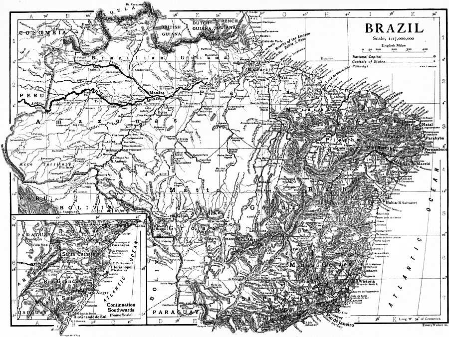
(Click to enlarge.)
Outside the two great river systems of the Amazon and river Plate (Rio de la Plata), which are treated under their respective titles, the rivers of Brazil are limited to the numerous small streams and three or four large rivers which flow Rivers. eastward from the plateau regions directly into the Atlantic. The Amazon system covers the entire north-western part of the republic, the state of Amazonas, nearly the whole of Pará and the greater part of Matto Grosso being drained by this great river and its tributaries. If the Tocantins-Araguaya basin is included in the hydrographic system, the greater part of Goyaz and a small part of Maranhão should be added to this drainage area. The Tocantins is sometimes treated as a tributary of the Amazon because its outlet, called the Rio Pará, is connected with that great river by a number of inland channels. It is an entirely separate river, however, and the inland communication between them is due to the slight elevation of the intervening country above their ordinary levels and to the enormous volume of water brought down by the Amazon, especially in the flood season. As the outlet of the Tocantins is so near to that of the Amazon, and their lower valleys are conterminous, it is convenient to treat them as parts of the same hydrographic basin.
In the extreme north-east corner of the republic where the Brazilian Guiana plateau slopes toward the Atlantic there is a small area lying outside the drainage basin of the Amazon. Its rivers flow easterly into the Atlantic and drain a triangular-shaped area of the plateau lying between the northern frontier and the southern and western watersheds of the Araguary, whose extreme limits are about 0° 30′ N. lat. and 53° 50′ W. long. The more important of these rivers are the Araguary, Amapá, Calçoene, Cassiporé and Oyapok. The Araguary rises in the Tumuc-Humac mountains, in about 2° 30′ N. lat., 52° 10′ W. long., and follows a tortuous course south and north-east to the Atlantic. Its largest tributary, the Amapary, rises still farther west. Little is known of the country through which it flows, and its channel is broken by rapids and waterfalls where it descends to the coastal plain. The Amapá is a short river rising on the eastern slopes of the same range and flowing across a low, wooded plain, filled with lagoons. The Calçoene and Cassiporé enter the Atlantic farther north and have a north-east course across the same plain. All these small rivers are described as auriferous and have attracted attention for this reason. The Oyapok, or Vicente Pinzon, is the best-known of the group and forms the boundary line between Brazil and French Guiana under the arbitration award of 1900. It rises in about 2° 05′ N., 53° 48′ W., and flows easterly and north-easterly to the Atlantic. Its course is less tortuous than that of the Araguary.
The rivers of the great Brazilian plateau which flow directly to the Atlantic coast may be divided into two classes: those of its northward slope which flow in a northerly and north-easterly direction to the north-east coast of the republic, and those which drain its eastern slope and flow to the sea in an easterly direction. The former reach the coastal plain over long and gradual descents, and are navigable for considerable distances. The latter descend from the plateau much nearer the coast, and are in most cases navigable for short distances only. In both classes navigation is greatly impeded by sandbars at the mouths of these rivers, while in the districts of periodical rainfall it is greatly restricted in the dry season. The more important rivers of the first division, which are described in more detail under the titles of the Brazilian states through which they flow, are the following: the Gurupy, Tury-assú, Mearim, Itapicurú and Balsas, in the state of Maranhão; the Parnahyba and its tributaries in Piauhy; Jaguaribe in Ceará; and the Apody and Piranhas in Rio Grande do Norte. Of these the Parnahyba is the most important, having a total length of about 900 m., broken at intervals by rapids and navigable in sections. It receives only one important tributary from Maranhão—the Rio das Balsas, 447 m. long—and five from Piauhy, the Urussuhy-assú, Gurgueia, Canindé, Poty and Longa. Piauhy is wholly within its drainage basin, although the river forms the boundary line between that state and Maranhão throughout its entire length. All the rivers in this division are influenced by the periodical character of the rainfall, their navigable channels being greatly shortened in the dry season (August-January). In Ceará the smaller rivers become dry channels in the dry season, and in protracted droughts the larger ones disappear also.
The rivers of the second division are included in a very great extension of coast and are influenced by wide differences in climate. Their character is also determined by the distance of the Serra do Mar from the coast, the more southern rivers having short precipitous courses. The more northern rivers are subject to periodical variations in volume caused by wet and dry seasons, but the greater distance of the coast range and the more gradual breaking down of the plateau toward the sea, give them longer courses and a greater extent of navigable water. North of the São Francisco the watershed projecting from the plateau eastward toward Cape St Roque, known as the Serra da Borborema in Parahyba and Rio Grande do Norte where its direction becomes north-east, leaves a triangular section of the easterly slope in which the river courses are short and much broken by rapids. The rainfall, also, is limited and uncertain. The largest of this group of small rivers is the Parahyba do Norte, belonging to the state of Parahyba, whose length is said to be less than 200 m., only 5 or 6 m. of which are navigable for small steamers. The São Francisco, which belongs to the inland plateau region, is the largest river of the eastern coast of Brazil and exists by virtue of climatic conditions wholly different from those of the coast where it enters the Atlantic. The tributaries of the lower half of this great river, which belong to the Atlantic coast region, are small and often dry, but the upper river where the rainfall is heavier and more regular receives several large affluents. The river is navigable up to the Paulo Affonso falls, 192 m. from the coast, and above the falls there is a much longer stretch of navigable water.
From the São Francisco to Cape Frio there are many short rivers rising on the slopes of the plateau and crossing the narrow coastal plain to the sea. There are also a few of greater length which rise far back on the plateau itself and flow down to the plain through deeply cut, precipitous courses. The navigable channels of these rivers are restricted to the coastal plain, except where a river has excavated for itself a valley back into the plateau. The more important of these rivers are the Itapicurú, Paraguassú, Contas or Jussiape, Pardo or Patype, and Jequitinhonha, of Bahia; the Mucury, and Doce, of Espirito Santo; and the Parahyba do Sul of the state of Rio de Janeiro. Of the Bahia group, the Jequitinhonha, sometimes called the Belmonte on its lower course, is the longest and most important, rising near Serro in the state of Minas Geraes and flowing in a curving north-east direction for a distance of about 500 m., 84 of which are navigable inland from the sea. The Mucury and Doce also rise in Minas Geraes, and are much broken in their descent to the lower plains, the former having a navigable channel of 98 m. and the latter of 138 m. The Parahyba, or Parahyba do Sul, which enters the sea about 30 m. north of Cape S. Thomé, is the largest and most important of the Atlantic coast rivers south of the São Francisco. It rises on an elevated tableland in the state of São Paulo and flows across the state of Rio de Janeiro from west to east, through a broad fertile valley producing coffee in its most elevated districts and sugar on its alluvial bottom-lands nearer the sea. It has a total length of 658 m., 57 of which are navigable between S. Fidelis and its mouth, and about 90 m. of its upper course.
South of Cape Frio there are no large rivers along the coast because of the proximity of the Serra do Mar—the coastal plain being very narrow and in places disappearing altogether. There are many short streams along this coast, fed by heavy rainfalls, but they have no geographic importance and no economic value under existing conditions. The largest of these and the only one of commercial value is the Ribeira de Iguape, which has its source on the tablelands of Paraná and after receiving several affluents west of the Serra do Mar breaks through a depression in that range and discharges into the Atlantic some miles below Santos on the southern boundary of the state of São Paulo. This river has a navigable channel of 118 m. below Xiririca, and communicates with an inland canal or waterway extending for many miles along this coast and known as the Iguape, or Mar Pequeno. In Rio Grande do Sul the Atlantic coastal plain extends westward more than half-way across the state, and is well watered by numerous streams flowing eastward to the Lagôa dos Patos. Of these only two are of large size—the Guayba and Camaquam. The first is formed by the confluence of the Jacuhy, Cahy, Sinos and Gravatahy, and is known under this name only from Porto Alegre to the Ponta de Itapuã, where it enters the Lagôa dos Patos. This river system drains a large part of the northern mountainous region of the state, and has a considerable extension of navigable channels between the plateau margin and the lake. In the extreme southern part of the state, the Lagôa Mirim empties into the Lagôa dos Patos through a navigable channel 61½ m. long, called the Rio São Gonçalo.
The Brazilian rivers of the Rio de la Plata system are numerous and important. Those of the Paraguay drain the south-western part of Matto Grosso, and the tributaries of the Paraná cover the western slopes of the Serra do Mar from Rio Grande do Sul north to the south-west part of Minas Geraes, and include the south-east part of Matto Grosso and the south part of Goyaz within their drainage basin. This is one of the most important fluvial systems of Brazil, but its economic value is impaired by the great waterfalls of Guayrá, or Sete Quedas, and Uribú-punga, and by the rapids and waterfalls in the majority of its affluents near their junction with the main stream. Between the two great waterfalls of the Paraná there is an open channel of 276 m., passing through a rich and healthy country, and receiving large tributaries from one of the most fertile regions of Brazil. Among the larger of these are the great falls of the Iguassú, near the junction of that river with the Paraná. Though the Uruguay plays a less important part, its relations to the country are similar to those of the Paraná, and its tributaries from the plateau region are similarly broken by falls and rapids. The Paraguay is in great part a lowland river, with a sluggish current, and is navigable by large river steamers up to Corumbá, and by smaller steamers to Cuyabá and the mouth of the Jaurú.
Compared with the number, length and volume of its rivers, Brazil has very few lakes, only two of which are noticeable for their size. There are a number of lakes in the lowland region of the Amazon valley, but these are mainly overflow Lakes. reservoirs whose areas expand and contract with the rise and fall of the great river. The coastal plain is also intersected by lagoons, lakes and inland channels formed by uplifted beaches. These inland channels often afford many miles of sheltered navigation. The lakes formed in this manner are generally shallow, and are sometimes associated with extensive swamps, as in southern Bahia. The lakes of the Alagôas coast, however, are long, narrow and deep, occupying valleys which were deeply excavated when the land stood at a higher level, and which were transformed into lakes by the elevation of the coast. The largest of these are the Lagôa do Norte, on whose margin stands the city of Maceió, and the Lagôa do Sul, a few miles south of that city. Both have outlets to the sea, and the former is salt There is a large number of these lakes along the coasts of Espirito Santo and Rio de Janeiro, some of them of considerable size. The two largest lakes of this class are on the coast of Rio Grande do Sul and are known as the Lagôa dos Patos and Lagôa Mirim. Both of these lakes lie nearly parallel with the coast line, are separated from the ocean by broad sand beaches filled with small lakes, and communicate with the ocean through the same channel. The Lagôa dos Patos is about 124 m. long with a maximum width of 37 m., and Lagôa Mirim is 108 m. long with a maximum width of 15 m. Both are navigable, though comparatively shallow and filled with sandbanks. So far as known, there are no lakes of noteworthy size in the interior of the country. There are a few small lakes in Maranhão and Piauhy, some in Goyaz in the great valley of the Araguaya, and a considerable number in Matto Grosso, especially in the Paraguay basin, where the sluggish current of that river is unable to carry away the rainfall in the rainy season.
The coast of Brazil is indented with a number of almost landlocked bays, forming spacious and accessible harbours. The larger and more important of these are Todos os Santos, on which is located the city of São Salvador or Bahia, and Coast. Rio de Janeiro or Guanabara, beside which stands the capital of the republic. These two are freely accessible to the largest ships afloat. The bays of Espirito Santo, Paranaguá and São Francisco have similar characteristics, but they are smaller and more difficult of access. The first is the harbour for the city of Victoria, and the other two for ports of the same name in southern Brazil. The port of Pernambuco, or Recife, is formed by a stone reef lying across the entrance to a shallow bay at the mouth of two small rivers, Beberibe and Capibaribe, and is accessible to steamers of medium draught. Santa Catharina and Maranhão have well-sheltered harbours formed by an island lying in the mouth of a large bay, but the latter is shallow and difficult of access. Pará, Parnahyba, Parahyba, Santos and Rio Grande do Sul are river ports situated near the sea on rivers having the same name; but, with the exception of Pará and Santos, they are difficult of access and are of secondary importance. There are still other bays along the coast which are well adapted for commercial purposes but are used only in the coasting trade. Many of the Atlantic coast rivers would afford excellent port facilities if obstructions were removed from their mouths.
Geology.—Brazil is a region which has been free from violent disturbances since an early geological period. It has, indeed, been subject to oscillations, but the movements have been regional in character and have not been accompanied by the formation of any mountain chain or any belt of intense folding. From the Devonian onwards the beds lie flat or dip at low angles. They are faulted but not sharply folded. The mountain ranges of the east of Brazil, from Cape St Roque to the mouth of the river Plate, are composed chiefly of crystalline and metamorphic rocks. Some of the metamorphic rocks may belong to the older Palaeozoic period, but the greater part of the series is probably Archaean. Similar rocks cover a large area in the province of Goyaz and in the south of the Matto Grosso, and they form, also, the hills which border the basin of the Amazon on the confines of Venezuela and Guiana. They constitute, in fact, an incomplete rim around the basin of sedimentary beds which occupies the Amazonian depression. In a large part of this basin the covering of sedimentary deposits is comparatively thin. The crystalline floor is exposed in the valleys of the Madeira, Xingú, &c. Some of the rocks thus exposed are, however, eruptive (e.g. in the Tapajoz), and probably do not belong to the Archaean. The crystalline rocks are succeeded by beds which have been referred to the Cambrian and Silurian systems. In the valley of the Trombetas, one of the northern tributaries of the Amazon, fossils have been found which indicate either the top of the Ordovician or the bottom of the Silurian. In the Maecuru, another northern affluent, graptolites of Ordovician age have been discovered, and Silurian fossils are said to have been found in the Maraca. Elsewhere the identification of the Silurian and older systems does not rest on palaeontological evidence. Devonian beds cover a much more extensive area. They crop out in a band some 25 to 50 m. north of the lower Amazon and in another band at a still greater distance south of that river. These bands are often concealed by more recent deposits, but it is clear that in this region the Devonian beds form a basin or synclinal with the Amazon for its axis. Devonian beds also lie upon the older rocks in the Matto Grosso and other provinces in the interior of Brazil, where they generally form plateaux of nearly horizontal strata. Fossils have been found in many localities. They belong to either the lower or the middle division of the Devonian system. The fauna shows striking analogies with that of the Bokkeveld beds of South Africa on the one hand and of the Hamilton group of North America on the other. The Carboniferous system in Brazil presents itself under two facies, the one marine and the other terrestrial. In the basin of the Lower Amazon the Carboniferous beds lie within the Devonian synclinal and crop out on both sides of the river next to the Devonian bands. There is a lower series consisting of sandstone and an upper series of limestone. The former appears to be almost unfossiliferous, the latter has yielded a rich marine fauna, which belongs to the top of the Carboniferous or to the Permo-carboniferous. In southern Brazil, on the other hand, in Rio Grande do Sul, Paraná, &c., the beds of this period are of terrestrial origin, containing coal seams and remains of plants. Some of the plants are European forms, others belong to the Glossopteris flora characteristic of India and South Africa. The beds are homotaxial with the Karharbári series of India, and represent either the top of the Carboniferous or the base of the Permian of Europe. The only Mesozoic system which is represented in Brazil by marine beds is the Cretaceous, and the marine facies, is restricted to the coasts and the basin of the Amazon. In the province of Sergipe, on the east coast, the beds are approximately on the horizon of the Cenomanian; in the valley of the Amazon they belong to the highest parts of the Cretaceous system, and the fauna shows Tertiary affinities. In the interior of Brazil, the Palaeozoic beds are directly overlaid by a series of red sandstones, &c., which appear to be of continental origin and of which the age is uncertain. Tertiary beds cover a considerable area, especially in the Amazonian depression. They consist chiefly of sands and clays of aeolian and freshwater origin. Of the Pleistocene and recent deposits the most interesting are the remains of extinct animals (Glyptodon, Mylodon, Megatherium, &c.) in the caves of the São Francisco.
From the above account it will appear that, excepting near the coast and in the basin of the Amazon, there is no evidence that any part of Brazil has been under the sea since the close of the Devonian period. During the Triassic and Jurassic periods even the basin of the Amazon appears to have been dry land. Eruptive rocks occur in the Devonian and Carboniferous beds, but there is no evidence of volcanic activity since the Palaeozoic epoch. The remarkable “stone reefs” of the north-east coast are ancient beaches hardened by the infiltration of carbonate of lime. They are quite distinct in their formation from the coral reefs of the same coast.
Climate.—Brazil lies almost wholly within the torrid zone, less than one-twelfth of its area lying south of the tropic of Capricorn. In general terms, it is a tropical country, with sub-tropical and temperate areas covering its three southern states and a great part of the elevated central plateau. The forest-covered, lowland valley of the Amazon is a region of high temperatures which vary little throughout the year, and of heavy rainfall. There is no appreciable change of seasons, except that produced by increased rainfall in the rainy season. The average temperature according to Castelnau is about 78°F., or 82.40° to 84.20° F. according to Agassiz. There is an increase in the rainfall from August to October, and again from November to March, the latter being the regular rainy season, but the time varies considerably between the valley of the upper Amazon and those of the upper Madeira and Negro. There is usually a short dry season on the upper Amazon in January and February, which causes two annual floods—that of November-December, and the great flood of March-June. The subsidence of the latter usually lasts until October. The average rainfall throughout the whole Amazon valley is estimated by Reclus as “probably in excess of 2 metres” (78.7 in.), and the maximum rise of the great flood is about 45 ft. The prevailing winds in the Amazon valley are easterly and westerly (or south-westerly), the former warm and charged with moisture, the latter dry and cold. The easterly winds, which are deflections of the trade winds, blow upstream with great regularity and force, more especially in the winter or dry season, and are felt as far inland as the mouths of the Madeira and Negro. Above these they are less regular and are attracted northward by the heated llanos of Venezuela in winter, or southward by the heated campos of Matto Grosso in summer. The cold south-westerly winds are felt when the sun is north of the equator, and are most severe, for a few days, in the month of May, when a tempo da friagem (cold period) causes much discomfort throughout the upper Amazon region. There are winter winds from the Andes, but in the summer season there are cold currents of air from up-river (ventos da cima) which are usually followed by downpours of rain.
The coastal plain as far south as Santos is a region of high temperatures and great humidity. The year is usually divided into a winter (inverno) and summer (verão), corresponding approximately to a dry and wet season. The “dry” season, however, is a season of moderate rainfall, except on the north-east coast where arid conditions prevail. Another exception is that of the Pernambuco coast, where the rainy season comes between March and August, with the heaviest rainfall from May to July, which is the time of the southern winter. Going southward there is also a gradual decrease in the mean annual temperature, the difference between Rio de Janeiro and the Amazon being about 5°. The north-east coast, which is sandy and barren, shows an average mean annual temperature (at Fortaleza) of nearly 80° F., which is slightly higher than those of Maranhão and Pará. At Pernambuco the mean summer temperature is 79.5° and that of winter 76.8°, which are about 3° lower than the mean temperature of Bahia in summer, and 5° higher than the Bahia mean in winter. South of Bahia there is a gradual increase in the rainfall, that of Rio de Janeiro exceeding 43 in. per annum. At Santos the rainfall is exceptionally heavy and the mean temperature high, but below that point the climatic conditions are considerably modified, the range in temperature being greater, the mean annual temperature lower, and the rainfall more evenly distributed throughout the year. The winds are more variable, and the seasons are more sharply defined. In Rio Grande do Sul the range in temperature is from 26° to 80°, the climate being similar to that of Uruguay. At Pelotas, a sea-level port on Lagôa dos Patos, the mean annual temperature is about 63° and the annual rainfall about 42 in. Extreme variations in temperature are often produced by cold south-west storms from the Argentine pampas, which sweep across southern Brazil as far north as Cape Frio, the fall in temperature sometimes being 22° to 27°. These storms usually last from two to three days and cause much discomfort. Winter rains are more frequent in southern Brazil, and violent storms prevail in August and September. At Blumenau, on the Santa Catharina coast, the annual rainfall is 53 in.
The climatic conditions of the Brazilian plateau are widely different from those of the coast in many respects. There is less uniformity in temperature, and the elevated chapadas are generally hotter during the day and cooler at night than are localities of the same latitude on the coast. The Brazilian Guiana plateau, lying immediately north of the equator, is in great part a hot, stony desert. Geographically it belongs to the Amazon basin, as its western and southern slopes are drained by tributaries of that great river. Climatically, however, it is a region apart. It lies in the north-east trade winds belt, but the mountain chain on its northern frontier robs these winds of their moisture and leaves the greater part of the Brazilian plateau rainless. Its eastern and western extremities, however, receive more rain, the former being well forested, while the latter is covered with grassy campos. South of the Amazon valley and filling a great part of the eastern projection of the continent, is another arid, semi-barren plateau, lying within the south-east trade winds belt, and extending from Piauhy southward to southern Bahia. It covers the state of Piauhy and the western or inland parts of the states of Ceará, Rio Grande do Norte, Parahyba, Pernambuco and Bahia. The year is divided into a dry and wet season, the first from June to December, when rain rarely falls, the streams dry up and the campos are burned bare, and the second from January to May when the rains are sometimes heavy and the campos are covered with luxuriant verdure. The rains are neither regular nor certain, however, and sometimes fail for a succession of years, causing destructive sêccas (droughts). The interior districts of Ceará, Pernambuco and Bahia have suffered severely from these sêccas. The sun temperature is high on these barren tablelands, but the nights are cool and refreshing. The prevailing winds are the south-east trades, which have lost some of their moisture in rising from the coastal plain. In summer, becoming warmed by the heated surface of the plateau, they sweep across it without a cloud or drop of rain. In winter the plateau is less heated, and cold currents of air from the west and south-west cause precipitation over a part if not all of this region. South and south-west of this arid plateau lie the inhabited tablelands of Rio de Janeiro, São Paulo and Minas Geraes, where the climate is greatly modified by a luxuriant vegetation and southerly winds, as well as by the elevation. Minas Geraes is forested along its water courses and along its southern border only; its sun temperature, therefore, is high and the rainfall in its northern districts is comparatively light. São Paulo is partly covered by open campos, and these also serve to augment the maximum temperature. In both of these states, however, the nights are cool, and the mean annual temperature ranges from 68° to 77°, the northern districts of Minas Geraes being much warmer than the southern. In São Paulo and southern Minas Geraes there are sometimes frosts. In the Parahyba valley, which extends across the state of Rio de Janeiro, the mean temperature is somewhat higher than it is in São Paulo and Minas Geraes, and the nights are warmer, but the higher valleys of the Serra do Mar enjoy a delightfully temperate climate. The rainfall throughout this region is abundant, except in northern Minas Geraes, where the climatic conditions are influenced to some extent by the arid eastern plateau. South of São Paulo the tablelands of Paraná, Santa Catharina and Rio Grande do Sul enjoy a temperate climate, with an abundant rainfall. There are occasional frosts, but snow is never seen. Of Goyaz and Matto Grosso very little can be said. The lower river valleys of the Tocantins-Araguaya, Xingú, Tapajós and Paraguay are essentially tropical, their climate being hot and humid like that of the Amazon. The higher valleys of the Paraná and its tributaries, and of the rivers which flow northward, are sub-tropical in character, having high sun temperatures and cool nights. Above these, the chapadas lie open to the sun and wind and have a cool, bracing atmosphere even where high sun temperatures prevail. The mean annual temperature at Goyaz (city), according to a limited number of observations, is about 77°. There is no absolutely dry season in this part of the great Brazilian plateau, though the year is customarily divided into a dry and wet season, the latter running from September to April in Goyaz, and from November to April in Matto Grosso. The prevailing winds are from the north-west in this region, and westerly winds in the rainy season are usually accompanied by rain.
Fauna.—The indigenous fauna of Brazil is noteworthy not only for the variety and number of its genera and species, but also for its deficiency in the larger mammals. Of this, one of the best authorities on the subject (H.W. Bates in The Naturalist on the River Amazons) says: “Brazil, moreover, is throughout poor in terrestrial mammals, and the species are of small size.” It is noteworthy, also, for the large number of species having arboreal habits, the density and extent of the Amazon forests favouring their development rather than the development of those of terrestrial habits. Of Quadrumana there are about fifty species in Brazil, all arboreal, thirty-eight of which inhabit the Amazon region. They belong mostly to the Cebidae family, and are provided with prehensile tails. The Carnivora are represented by six species of the Felidae, the best known of which is the onça, or jaguar (F. onça, L.), and the cougar, or puma (F. concolor); three species of the Canidae, the South American wolf (C. jubatus), and two small jackals (C. brasiliensis and C. vetulus); and a few species of the Mustelina including two of the otter, two Galictis and one Mephitis. Of the plantigrades, Brazil has no bears, but has the related species of raccoon (Nasua socialis and N. solitaria), popularly called coatis. The opossum (Didelphis) is represented by three or four species, two of which are so small that they are generally called wood rats. The rodents are numerous and include several peculiar species. Only one species of hare is found in Brazil, the Lepus brasiliensis, and but one also of the squirrel (Scyurus). Of the amphibious rodents, the prêá (Cavia aperea), mocó (C. rupestris), paca (Coelogenys paca), cutia (Dasyprocta aguti) and capybara (Hydrochoerus capybara) are noteworthy for their size and extensive range. Their flesh is used as an article of food, that of the paca being highly esteemed. Of the Muridae there are several genera and a large number of species, some of them evidently importations from the Old World. Brazil has three groups of animals similar to the common rat—the Capromydae, Loncheridae and Psammoryctidae—the best known of which is the “tuco-tuco” (Clenomys brasiliensis), a small burrowing animal of Rio Grande do Sul which excavates long subterranean galleries and lives on roots and bulbs. One of the characteristic orders of the Brazilian fauna is that of the Edentata, which comprises the sloth, armadillo and ant-eater. These animals are found only in the tropical regions of South America. The range of the sloth is from the Guianas south into Minas Geraes, the armadillo as far south as the Argentine pampas and the ant-eater from the Amazon south to Paraguay, though it is found in the Amazon region principally. The sloth (Bradypus) is an arboreal animal which feeds almost exclusively on the foliage of the Cecropias. It includes two recognized genera and half a dozen species, the best known of which is B. didactylus. The common name in Brazil is preguiça, which is equivalent to its English name. Of armadillos, commonly called tatú in Brazil, the largest species is the Dasypus gigas, but the best known is the tatú-été (D. octocinctus), which is highly esteemed for its flesh. The ant-eaters (Myrmecophaga) are divided into three or four species, one of which (M. jubata) is exclusively terrestrial, and the others arboreal. The popular name for the animal is tamanduá. The M. jubata, or tamanduá bandeira, is sometimes found as far south as Paraguay. Of the ruminants, Brazil has only four or five species of Cervidae, which are likewise common to other countries of South America. The largest of these is the marsh deer (C. paludosus), which in size resembles its European congeners. The others are the C. campestris, C. nemorivagus, C. rufus and a small species or variety called C. nanus by the Danish naturalist Dr P.W. Lund. The pachyderms are represented by three species of the peccary (Dicotyles) and two of the anta, or tapir (Tapirus). The former are found over a wide range of country, extending into Bolivia and Argentina, and are noted for their impetuous pugnacity. The tapir also has an extensive range between the coast and the foothills of the Andes, and from northern Argentina to south-eastern Colombia. It is the largest of the Brazilian mammals, and inhabits densely forested tracts near river courses. The two species are T. americanus, which is the larger and best known, and the anta chure, found in Minas Geraes, which is said to be identical with the T. Roulini of Colombia. Perhaps the most interesting mammal of Brazil is the manati, or sea-cow (Manatus americanus), which inhabits the lower Amazon and sometimes reaches a length of 15 to 20 ft. It is taken with the harpoon and its oil is one of the commercial products of the Amazon valley.
The avifauna of Brazil is rich in genera, species and individuals, especially in species with brilliantly-coloured plumage. It is estimated that more than half the birds of Brazil are insectivorous, and that more than one-eighth are climbers. The range in size is a wide one—from the tiny humming-bird to the ema, rhea, or American ostrich. Although the order which includes song-birds is numerous in species and individuals, it is noticeably poor in really good songsters. On the other hand it is exceptionally rich in species having strident voices and peculiar unmusical calls, like the pacô (Coracina scuttata) and the araponga (Chasmorhynchus nudicollis). Two species of vultures, twenty-three of falcons and eight of owls represent the birds of prey. The best known vulture is the common urubú (Cathartes foetens, Illig), which is the universal scavenger of the tropics. The climbers comprise a large number of species, some of which, like those of the parrot (Psittacidae) and woodpecker (Picus), are particularly noticeable in every wooded region of the country. One of the most striking species of the former is the brilliantly-coloured arara (Macrocercus, L.), which is common throughout northern Brazil. Another interesting species is the toucan (Ramphastos), whose enormous beak, awkward flight and raucous voice make it a conspicuous object in the great forests of northern Brazil. In strong contrast to the ungainly toucan is the tiny humming-bird, whose beautiful plumage, swiftness of flight and power of wing are sources of constant wonder and admiration. Of this smallest of birds there are fifty-nine well-known species, divided into two groups, the Phaethorninae, which prefer the forest shade and live on insects, and the Trochilinae, which frequent open sunny places where flowers are to be found. One of the Brazilian birds whose habits have attracted much interest is the João de Barro (Clay John) or oven bird (Furnarius rufus), which builds a house of reddish clay for its nest and attaches it to the branch of a tree, usually in a fork. The thrush is represented by a number of species, one of which, the sabiá (Mimus), has become the popular song-bird of Brazil through a poem written by Gonçalves Dias. The dove and pigeon have also a number of native species, one of which, the pomba jurity (Peristera frontalis), is a highly-appreciated table luxury. The gallinaceous birds are well represented, especially in game birds. The most numerous of these are the perdiz (partridge), the best known of which is the Tinamus maculosa which frequents the campos of the south, the inhambú (Crypturus), capoeira (Odontophorus), and several species of the penelope family popularly known as the jacutinga, jacú and jacú-assú. The common domesticated fowl is not indigenous. Among the wading and running birds, of which the ema is the largest representative, there are many species of both descriptions. In the Amazon lowlands are white herons (Ardea candidissima), egrets (A. egretta), bitterns (A. exilis), blue herons (A. herodias) scarlet ibises (Ibis rubra), roseate spoonbills (Platalea ajaja); on higher ground the beautiful peacock heron (A. helias) which is easily domesticated; and on the dry elevated campos the ceriema (Dicholophus cristatus) which is prized for its flesh, and the jacamin (Psophia crepitans) which is frequently domesticated. Prominent among the storks is the great black-headed white crane, called the jaburú (Mycteria americana), which is found along the Amazon and down the coast and grows to a height of 4½ ft. Of the swimmers, the number of species is smaller, but some of them are widely distributed and numerous in individuals. There are but few species of ducks, and they are apparently more numerous in southern Brazil than on the Amazon.
The reptilian fauna exhibits an exceptionally large number of interesting genera and species. A great part of the river systems of the country with their flooded areas are highly favourable to the development of reptilian life. Most prominent among these is the American alligator, of which there are, according to Netterer, two genera and eight species in Brazil. They are very numerous in the Amazon and its tributaries and in the Paraguay, and are found in all the rivers of the Atlantic coast. Three of the Brazilian species are voracious and dangerous. The largest of the Amazon species are the jacaré-assú (Caïman niger), jacaré (C. fissipes) and jacaré-tinga (C. sclerops). The Amazon is also the home of one of the largest fresh-water turtles known, the Emys amazonica, locally called the jurará-assú or tartaruga grande. These turtles are so numerous that their flesh and eggs have long been a principal food supply for the Indian population of that region. Another Amazon species, the E. tracaxa, is still more highly esteemed for its flesh, but it is smaller and deposits fewer eggs in the sandy river beaches. Lagartos (Iguanas) and lizards are common everywhere. The ophidians are also numerous, especially in the wooded lowlands valleys, and the poisonous species, though less numerous than others, include some of the most dangerous known—the rattlesnake surucucú (Lachesis rhombeatus), and jararáca (Bothrops). The Amazon region is frequented by the giboia (boa constrictor), and the central plateau by the sucuriú (Eunectes murinus), both distinguished for their enormous size. The batrachians include a very large number of genera and species, especially in the Amazon valley.
The fauna of the rivers and coast of Brazil is richer in species and individuals than that of the land. All the rivers are richly stocked, and valuable fishing grounds are to be found along the coast, especially that of southern Bahia and Espirito Santo where the garoupa (Serranus) is found in large numbers. Some of the small fish along the coast are highly esteemed for their flavour. Whales were once numerous between Capes St Roque and Frio, but are now rarely seen. Of the edible river fish, the best known is the pirarucú (Sudis gigas), a large fish of the Amazon which is salted and dried for market during the low-water season. Fish is a staple food of the Indian tribes of the Amazon region, and their fishing season is during the period of low water. The visit of Professor Louis Agassiz to the Amazon in 1865 resulted in a list of 1143 species, but it is believed that no less than 1800 to 2000 species are to be found in that great river and its tributaries.
In strong contrast to the poverty of Brazil in the larger mammals is the astonishing profusion of insect life in every part of the country. The Coleoptera and Lepidoptera are especially numerous, both in species and individuals. A striking illustration of this extraordinary profusion was given by the English naturalist H.W. Bates, who found 7000 species of insects in the vicinity of only one of his collecting places on the Amazon (Ega), of which 550 species were of butterflies. Within an hour’s walk of Pará are to be found, he says, about 700 species of butterflies, “whilst the total number found in the British Islands does not exceed 66, and the whole of Europe supports only 321.” (H.W. Bates, The Naturalist on the River Amazons.) One of the rare species of the Amazon Morphos (M. hecuba) measures 8 to 9 in. across its expanded wings. Dipterous insects are also very numerous in species, especially in those of sanguinary habits, such as the mosquito, pium, maroim, carapanā, borochudo, &c. In some places these insects constitute a veritable plague, and the infested regions are practically uninhabitable. The related species of the Oestridae family, which include the widely disseminated chigoe or bicho do pé (Pulex penetrans), and the equally troublesome berne (Cutiterebra noxialis), which is so injurious to animals, are equally numerous. The most numerous of all, however, and perhaps the most harmful to civilized man, are the termites and ants, which are found everywhere in the uninhabited campo and forest regions, as well as in the cultivated districts. Nature has provided several species of animals, birds and reptiles, to feed upon these insects, and various poisonous and suffocating compounds are used to destroy them, but with no great degree of success. It is not uncommon to find once cultivated fields abandoned because of their ravages and to see large campos completely covered with enormous ant-hills. The termites, or “white ants,” are exceptionally destructive because of their habit of tunnelling through the softer woods of habitations and furniture, while some species of ants, like the saúba, are equally destructive to plantations because of the rapidity with which they strip a tree of its foliage. Spiders are represented by a very large number of species, some of which are beautifully coloured. The largest of these is the Mygale with a body 2 in. in length and outstretched legs covering 7 in., a monster strong enough to capture and kill small birds. A large Mygale found on the island of Siriba, of the Abrolhos group, feeds upon lizards, and has been known to attack and kill young chickens. One of the most troublesome pests of the interior is a minute degenerate spider of the genus Ixodes, called carrapato, or bush-tick, which breeds on the ground and then creeps up the grass blades and bushes where it waits for some passing man or beast. Its habit is to bury its head in its victim’s skin and remain there until gorged with blood, when it drops off. Scorpions are common, but are considered less poisonous than some European species.
Flora.—Brazil not only is marvellously rich in botanical species, but included at the beginning of the 20th century the largest area of virgin forest on the surface of the earth. The flora falls naturally into three great divisions: that of the Amazon basin where exceptional conditions of heat and moisture prevail; that of the coast where heat, varying rainfall, oceanic influences and changing seasons have greatly modified the general character of the vegetation; and that of the elevated interior, or sertão, where dryer conditions, rocky surfaces, higher sun temperatures and large open spaces produce a vegetation widely different from those of the other two regions. Besides these, the flora of the Paraguay basin varies widely from that of the inland plateau, and that of the Brazilian Guiana region is essentially distinct from the Amazon. The latter region is densely forested from the Atlantic to the Andes, but with a varying width of about 200 m. on the coast to about 900 m. between the Bolivian and Venezuelan llanos, and thus far civilization has made only a very slight impression upon it. Even where settlements have been located, constant effort is required to keep the vegetation down. Along the coast, much of the virgin forest has been cut away, not only for the creation of cultivated plantations, but to meet the commercial demand for Brazil-wood and furniture woods.
The chief characteristic of the Amazonian forest, aside from its magnitude, is the great diversity of genera and species. In the northern temperate zone we find forests of a single species, others of three or four species; in this great tropical forest the habit of growth is solitary and an acre of ground will contain hundreds of species—palms, myrtles, acacias, mimosas, cecropias, euphorbias, malvaceas, laurels, cedrellas, bignonias, bombaceas, apocyneas, malpigias, lecythises, swartzias, &c. The vegetation of the lower river-margins, which are periodically flooded, differs in some particulars from that of the higher ground, and the same variation is to be found between the forests of the upper and lower Amazon, and between the Amazon and its principal tributaries. The density of the forest is greatly augmented by the cipós, or lianas, which overgrow the largest trees to their tops, and by a profusion of epiphytes which cover the highest branches. As a rule the trees of the Amazon forest are not conspicuously high, a few species rarely reaching a height of 200 ft. The average is probably less than one-half that height. This is especially true of the flood plains where the annual inundations prevent the formation of humus and retard forest growth. The largest of the Amazon forest trees are the massaranduba (Mimusops elata), called the cow-tree because of its milky sap, the samaúma (Eriodendron samauma) or silk-cotton tree, the páu d’ arco (Tecoma speciosa), páu d’ alho (Catraeva tapia), bacori (Symphonea coccinea), sapucaia (Lecythis ollaria), and castanheira or brazil-nut tree (Bertholletia excelsa). The Amazon region has a comparatively narrow frontage on the Atlantic. In Maranhão, which belongs to the coast region, open spaces or campos appear, though the state is well wooded and its forests have the general characteristics of the lower Amazon. South-east of the Parnahyba the coast region becomes dryer and more sandy and the forests disappear. The coast and tide-water rivers are fringed with mangrove, and the sandy plain reaching back to the margin of the inland plateau is generally bare of vegetation, though the carnahuba palm (Copernicia cerifera) and some species of low-growing trees are to be found in many places. The higher levels of this plain are covered with shrubs and small trees, principally mimosas. The slopes of the plateau, which receive a better rainfall, are more heavily forested, some districts being covered with deciduous trees, forming catingas in local parlance. This dry, thinly-wooded region extends south to the states of Parahyba, where a more regular rainfall favours forest growth nearer the coast. Between Parahyba and southern Bahia forests and open plains are intermingled; thence southward the narrow coastal plain and bordering mountain slopes are heavily forested. The sea-coast, bays and tide-water rivers are still fringed with mangrove, and on the sandy shores above Cape Frio grow large numbers of the exotic cocoa-nut palm. Many species of indigenous palms abound, and in places the forests are indescribably luxuriant. These are made up, as Prince Max zu Neuwied found in southern Bahia in 1817, “of the genera Cocos, Melastoma, Bignonia, Rhexia, Mimosa, Ingá, Bombax, Ilex, Laurus, Myrthus, Eugenia, Jacarandá, Jatropha, Visinia, Lecythis, Ficus, and a thousand other, for the most part, unknown species of trees.” Further inland the higher country becomes more open and the forests are less luxuriant. Giant cacti and spiny scrub abound. Then come the catinga tracts, and, beyond these, the open campos of the elevated plateau, dotted with clumps of low growing bushes and broken by tracts of carrasco, a thick, matted, bushy growth 10 to 12 ft. in height. Formerly this coast region furnished large quantities of Brazil-wood (Caesalpinia echinata), and the river valleys have long been the principal source of Brazil’s best cabinet-wood—rosewood (Dalbergia nigra), jacarandá (Machaeriumfirmum, Benth.), vinhatico (Plathymenia foliosa, Benth.), peroba (Aspidosperma peroba), cedro, &c. The exotic mangabeira (mango) is found everywhere along the coast, together with the bamboo, orange, lemon, banana, cashew, &c.
Of the great inland region, which includes the arid campos of the north, the partially-wooded plateaus of Minas Geraes, Goyaz and Matto Grosso, the temperate highlands of the south, and the tropical lowlands of the Paraguay basin, no adequate description can be given without taking each section in detail, which can be done to better advantage in describing the individual states. In general, the carrasco growth extends over the whole central plateau, and heavy forests are found only in the deep river valleys. Those opening northward have the characteristic flora of the Amazon basin. The Paraguay basin is covered with extensive marshy tracts and open woodlands, the palms being the conspicuous feature. The vegetation is similar to that of Paraguay and the Chaco, and aquatic plants are specially numerous and luxuriant. On the temperate uplands of the southern states there are imposing forests of South American pine (Araucaria brasiliensis), whose bare trunks and umbrella-like tops give to them the appearance of open woodland. These forests extend from Paraná into Rio Grande do Sul and smaller tracts are also found in Minas Geraes. Large tracts of Ilex paraguayensis, from which maté, or Paraguay-tea, is gathered, are found in this same region.
The economic plants of Brazil, both indigenous and exotic, are noticeably numerous. Coffee naturally occupies first place, and is grown wherever frosts are not severe from the Amazon south to Paraná. The states of São Paulo, Rio de Janeiro and Minas Geraes are the largest producers, but it is also grown for export in Espirito Santo, Bahia and Ceará. The export in 1905 was 10,820,604 bags of 132 ℔ each, with an official valuation of £21,420,330. Sugar cane, another exotic, has an equally wide distribution, and cotton is grown along the coast from Maranhão to São Paulo. Other economic plants and fruits having a wide distribution are tobacco, maize, rice, beans, sweet potatoes, bananas, cacáo (Theobroma cacao), mandioca or cassava (Manihot utilitissima), aipim or sweet mandioca (M. aipi), guavas (Psidium guayava, Raddi), oranges, lemons, limes, grapes, pineapples, mamão (Carica papaya), bread-fruit (Artocarpus incisa), jack fruit (A. integrifolia), and many others less known outside the tropics. Among the palms there are several of great economic value, not only as food producers but also for various domestic uses. The fruit of the pupunha or peach palm (Guilielma speciosa) is an important food among the Indians of the Amazon valley, where the tree was cultivated by them long before the discovery of America. Humboldt found it among the native tribes of the Orinoco valley, where it is called pirijao. The ita palm, Mauritia, flexuosa (a fan-leaf palm) provides an edible fruit, medullary meal, drink, fibre, roofing and timber, but is less used on the Amazon than it is on the lower Orinoco. The assaí (Euterpe oleracea) is another highly-prized palm because of a beverage made from its fruit along the lower Amazon. A closely-related species or variety (Euterpe edulis) is the well-known palmito or cabbage palm found over the greater part of Brazil, whose terminal phylophore is cooked and eaten as a vegetable. Another highly useful palm is the carnauba or carnahuba (Copernicia cerifera) which supplies fruit, medullary meal, food for cattle, boards and timber, fibre, wax and medicine. The fibre of the piassava (Leopoldinia piassava, or Attalea funifera) is widely used for cordage, brushes and brooms. There are many other palms whose fruit, fibre and wood enter largely into the domestic economy of the natives, but the list given shows how important a service these trees rendered to the aboriginal inhabitants of tropical America, and likewise how useful they still are to the people of tropical Brazil. Another vegetable product of the Amazon region is made from the fruit of the Paullinia sorbilis, Mart., and is known by the name of guaraná. It is largely consumed in Bolivia and Matto Grosso, where it is used in the preparation of a beverage which has excellent medicinal properties. The Brazilian flora is also rich in medicinal and aromatic plants, dye-woods, and a wide range of gum and resin-producing shrubs and trees. The best known of these are sarsaparilla, ipecacuanhá, cinchona, jaborandi and copaiba; vanilla, tonka beans and cloves; Brazil-wood and anatto (Bixa orellana); india-rubber and balata. India-rubber is derived principally from the Hevea guayanensis, sometimes called the Siphonia elastica, which is found on the Amazon and its tributaries as far inland as the foothills of the Andes. Other rubber-producing trees are the maniçoba (Jatropha Glasiovii) of Ceará, and the mangabeira (Hancornia speciosa), of the central upland regions.
Population.—The first explorers of Brazil reported a numerous Indian population, but, as the sea-coast afforded a larger and more easily acquired food supply than did the interior, the Indian population was probably numerous only in a comparatively small part of this immense territory, along the sea-coast. Modern explorations have shown that the unsettled inland regions of Brazil are populated by Indians only where the conditions are favourable. They are to be found in wooded districts near rivers, and are rarely found on the elevated campos. The immediate result of European colonization was the enslavement and extermination of the Indians along the coast and in all those favoured inland localities where the whites came into contact with them. The southern districts and the Amazon and its tributaries were often raided by slave-hunting expeditions, and their Indian populations were either decimated, or driven farther into the inaccessible forests. But there is no record that the inland districts of western and north-western Brazil were treated in this manner, and their present population may be assumed to represent approximately what it was when the Europeans first came. According to the census of 1890 the Indian population was 1,295,796, but so far as the migratory tribes are concerned the figures are only guesswork. A considerable number of these Indians have been gathered together in aldeas under the charge of government tutors, but the larger part still live in their own villages or as nomads.
Down to the beginning of the 19th century the white colonists were almost exclusively Portuguese. The immigration from countries other than Portugal during the first half of that century was small, but before its close it increased rapidly, particularly from Italy. Fully nine-tenths of these immigrants, including those from the mother country, were of the Latin race. The introduction of African slaves followed closely upon the development of agricultural industries, and continued nominally until 1850, actually until 1854, and according to some authors until 1860. About 1826 it was estimated that the negro population numbered 2,500,000 or three times the white population of that period. The unrestricted intermixture of these three races forms the principal basis of the Brazilian population at the beginning of the 20th century. Brazil has never had a “colour line,” and there has never been any popular prejudice against race mixtures. According to the census of 1872 the total population was 9,930,478, of which 1,510,806 were slaves; the race enumeration gave 3,787,289 whites, 1,959,452 Africans, 386,955 Indians, and 3,801,782 mixed bloods. The Indian population certainly exceeded the total given, and the white population must have included many of mixed blood, the habit of so describing themselves being common among the better classes of South American mestizos. The census of 1890 increased the total population to 14,333,915, which, according to an unofficial analysis (Statesman’s Year Book, 1905), was made up of 6,302,198 whites, 4,638,495 mixed bloods, 2,097,426 Africans, and 1,295,796 Indians. This analysis, if correct, indicates that the vegetative increase of the whites has been greater than that of the Africans and mixed races. This is not the conclusion of many observers, but it may be due to the excessive infant mortality among the lower classes, where an observance of the simplest sanitary laws is practically unknown. The census of the 31st of December 1900 was strikingly defective; it was wholly discarded for the city of Rio de Janeiro, and had to be completed by office computations in the returns from several states. The compilation of the returns was not completed and published until May 1908, according to which the total population was 17,318,556, of which 8,825,636 were males and 8,492,920 females. Not including the city of Rio de Janeiro, whose population was estimated at 691,565 in conformity with a special municipal census of 1906, the total population was 16,626,991, of which 15,572,671 were Roman Catholics, 177,727 Protestants, 876,593 of other faiths. The returns also show a total of 3,038,500 domiciles outside the federal capital, which gives an average of 5.472 to the domicile. These returns will serve to correct the exaggerated estimate of 22,315,000 for 1900 which was published in Brazil and accepted by many foreign publications.
The racial character of the people is not uniform throughout the republic, the whites predominating in the southern states, the Indians in Amazonas and, probably, Matto Grosso, and the mixed races in the central and northern coast states. The excess of whites over the coloured races in the southern states is due to their smaller slave population and to the large number of immigrants attracted to them. Slavery was not abolished until the 13th of May 1888, but a number of successful colonies had already been founded in these states. Other colonies were founded in Bahia, Espirito Santo and Rio de Janeiro during the same period, but they were unsuccessful, partly because of the competition of slave labour. Since the abolition of slavery immigration has poured a large number of labourers into the coffee-producing states, and with beneficial results. This strengthening of the white population of the South with fresh European blood must eventually divide Brazil into two distinct sections: the white states of the south, and the mixed or coloured states of the north. The introduction of European immigrants dates from 1818 when a Swiss colony was located at Nova Friburgo, near Rio de Janeiro, and it was continued under the direction and with the aid of the imperial government down to the creation of the republic. Since then the state governments have assumed charge of immigration, and some of them are spending large sums in the acquisition of labourers. The old system of locating immigrants in colonies, or colonial nuclei, which involved an enormous outlay of money with but slight benefit to the country, has been superseded by a system of locating the immigrants on the large plantations under formal contracts. In some of the coffee districts these contracts have resulted very profitably to the Italian labourers. The total number of colonists and immigrants entering Brazil between 1804 and 1902, inclusive, according to official returns, was 2,208,353. The arrivals fluctuate greatly in number from year to year, influenced by the prevailing economic conditions in the country. At first the Portuguese outnumbered all other nationalities in the immigration returns, but since the abolition of slavery the Italians have passed all competitors and number more than one-half the total arrivals. Of the 700,211 immigrants located in the state of São Paulo from 1827 to the end of 1896, no less than 493,535 were Italians, and their aggregate throughout the republic was estimated in 1906 at more than 1,100,000. The German immigration, of which so much has been written for political ends, has been greatly over-estimated; trustworthy estimates in 1906 made the German contingent in the population vary from 350,000 to 500,000. They are settled chiefly in colonies in the southern states, and form a most desirable body of settlers.
Divisions and Towns.—The republic is divided into twenty states and one federal district, which are the same as the provinces and “municipio neutro” of the empire. Their names also remain unchanged, except that of the federalized district in which the national capital is located, which is called the “districto federal.” The republic has no territories, although Amazonas, Matto Grosso, Pará and Goyaz cover an immense region of uninhabited and only partially explored territory. The states are subdivided into comarcas, or judicial districts, and into municipios, or townships, which is the smallest autonomous division. The constitution provides for the autonomy of the municipalities in order to safeguard the permanence of representative institutions. The parochia, or parish, an ecclesiastical division, is often used for administrative purposes, but it has no political organization. The names, areas, and populations of the states, together with the names and populations of their capitals, are as follows:—
States. Area,1 Sq. miles. Population2 State Capitals. Population,3 Census 1890.
Census 1890. Census 1900.
Alagôas 22,584 511,440 649,273 Maceió 31,498
Amazonas 742,123 147,915 249,756 Manáos 38,720
Bahia 164,650 1,919,802 2,117,956 São Salvador4 174,412
Ceará 40,253 805,687 849,127 Fortaleza 40,902
Espirito Santo 17,313 135,997 209,783 Victoria 16,887
Federal District 538 522,651 691,565 Rio de Janeiro 522,651
Goyaz 288,549 227,572 255,284 Goyaz4 17,181
Maranhão 177,569 430,854 499,308 S. Luiz do Maranhão4 29,308
Matto Grosso 532,370 92,827 118,025 Cuyabá 17,815
Minas Geraes 221,961 3,184,099 3,594,471 Ouro Preto5 59,249
Pará 443,922 328,455 445,356 Belem4 50,064
Parahyba 28,855 457,232 490,784 Parahyba 18,645
Paraná 85,455 249,491 327,136 Curityba 24,553
Pernambuco 49,575 1,030,224 1,178,150 Recife4 111,556
Piauhy 116,529 267,609 334,328 Therezina 31,523
Rio de Janeiro 26,635 276,884| 274,317 Nictheroy 34,269
Rio Grande do Norte 22,196 268,273 1,149,070 Natal 13,725
Rio Grande do Sul 91,337 897,455 926,035 Porto Alegre 52,421
Santa Catharina 28,633 283,769 320,289 Desterro6 30,637
São Paulo 112,312 1,384,753 2,282,279 São Paulo 64,934
Sergipe 15,093 310,926 356,264 Ararajú 16,336
Brazil 3,228,452 14,333,915 17,318,556
Communications.—Railway construction in Brazil dates from 1852, when work was initiated on the Mauá railway running from the head of the bay of Rio de Janeiro to the foot of the Serra where Petropolis is situated. The road is 10 m. long, and its first section was opened to traffic on April 30, 1854, and its second December 16, 1856. The mountain section, 5½ m. long, which uses the Riggenbach system from the terminal to Petropolis, was constructed between 1881 and 1883. The development of railway construction in Brazil has been impeded to a great extent by two unfavourable conditions—by the chain of mountains or plateau escarpments which follow the coast line and obstruct communication with the interior, and by the detached positions of the settlements along the Atlantic, which compel the building of lines from many widely separated points on the coast into a sparsely populated hinterland. A majority of the ports, from which these roads are built, are small and difficult of access, and the coasting trade is restricted to vessels carrying the Brazilian flag. The only ports having a rich and well-populated country behind them are Rio de Janeiro and Santos, and these are the terminals of long lines of railway which are being slowly extended farther into the interior.
The total mileage under traffic at the beginning of 1905 was 10,600 m., divided into 94 separate lines. There were also 745 m. under construction, 1740 m. under survey, and about 1600 m. projected. Of the 94 lines under traffic, 45 were operating by virtue of national and 49 by provincial and state concessions. They were grouped in the official reports of 1905 as follows:—
Government lines (21):— Miles.
Administered by the state (6) 2228
Leased to private parties (15) 2174
—— 4402
Private lines (24)—
With national interest guarantees (12) 1290
Without such guarantees (12) 815
—— 2105
Private and state lines operated by virtue of state
concessions, with and without interest guarantees (49) 4093
———
10,600
======
The policy of the national government has been gradually to lease all its lines except the Estrada de Ferro Central do Brazil, which is retained for sentimental reasons. This great railway runs from the city of Rio de Janeiro westward to the city of São Paulo and northward into the interior of Minas Geraes, with a total length at the beginning of 1905 of 1002 m., and an extension of about 104 m. to Pirapora, on the São Francisco river. It was formerly known as the “E. de F. Dom Pedro II.,” in honour of the sovereign who encouraged its construction. The main line has a gauge of 63 in. (1.60 m.) and affords an outlet for a number of inland metre-gauge lines. The first two sections of this great railway, which carry it across the coast range, were opened to traffic in 1858 and 1864. The series of trunk lines terminating at the port of Santos are owned by private companies and are formed by the São Paulo, Paulista and Mogyana lines, the first owned by an English company, and the other two by Brazilian companies. The Mogyana carries the system entirely across the state of São Paulo into the western districts of Minas Geraes. The principal trunk lines (the São Paulo and Paulista) have a broad gauge, while their extensions and feeders have a narrow gauge. The comparatively short lines extending inland from the ports of São Salvador (Bahia), Pernambuco, Maceió, Victoria and Paranaguá serve only a narrow zone along the coast. To encourage the investment of private capital in the construction of railways, the general railway law of 1853 authorized the national government to grant guarantees of interest on the capital invested. Under this law companies were organized in England for building the São Paulo railway, and the lines running from Bahia and Pernambuco toward the São Francisco river. Political considerations also led to the construction of similar lines in the states of Rio Grande do Norte, Parahyba, Alagôas, Sergipe, Espirito Santo, Paraná, Santa Catharina and Rio Grande do Sul. The result was that the national treasury became burdened with a heavy annual interest charge, payable abroad in gold, which did not tend to diminish, and had a long period to run before the expiration of the contracts. The government finally determined to take over these guaranteed lines from the foreign companies owning them, and a statement issued in October 1902 showed that 1335 m. had been acquired at a cost of £14,605,000 in bonds, the interest on which is £584,200 a year against an aggregate of £831,750 in interest guarantees which the government had been paying. In addition to this economy it was calculated that the lines could be leased for £132,000 a year. The loan finally issued in London to cover the purchase of these railways aggregated £16,619,320. All but three of these lines had been leased in 1905.
The use of tramways for the transportation of passengers in cities dates from 1868, when the first section of the Botanical Garden line of Rio de Janeiro was opened to traffic. The line was completed with its surplus earnings and continued under the control of the American company which built it until 1882, when it was sold to a Brazilian company. Subsequently the tramways of the city have been mostly concentrated in the hands of a single Canadian company. All the large cities of Brazil are liberally provided with tramways, those of the city of São Paulo, where electric traction is used, being noticeably good. The substitution of electricity for animal traction was begun in São Salvador in 1906. Mules are universally employed for animal traction, and narrow gauge lines with single-mule trams are generally used where the traffic is light.
Brazil is lamentably deficient in steamship communication considering its importance in a country where the centres of population are separated by such distances of coasts and river. Previous to the creation of the republic, the coastwise service was performed by two national companies (now united), and partially by foreign lines calling at two or more ports. A considerable number of foreign sailing vessels also carried on an important coasting trade. The coastwise service centres at Rio de Janeiro, from which port the Lloyd Brazileiro sends steamers regularly south to Montevideo, and north to Pará and Manáos, calling at the more important intermediate ports. From Montevideo river steamers are sent up the Paraná and Paraguay rivers to Corumbá and Cuyabá, in the state of Matto Grosso. The company receives a heavy subsidy from the national government. Parts of this coastwise traffic are covered by other companies, two of which receive subsidies. There were also six lines of river steamers receiving subsidies from the national government in 1904, and the aggregate paid to these and the coastwise lines was 2,830,061 milreis. The largest of the river lines is the Amazon Steam Navigation Co. (an English corporation), whose service covers the main river and several of its principal tributaries. Two subsidized companies maintain services on the São Francisco river—one below the Paulo Affonso falls, and the other above, the latter covering 854 m. of navigable channel between Joazeiro and Pirapora. Besides these there are other companies engaged in the coasting and river traffic, either with subsidies from the state governments, as feeders for railway lines, or as private unsubsidized undertakings.
The telegraph lines, which date from 1852, are owned and operated by the national government, with the exception of the lines constructed by private railway companies, and the cable lines of the Amazon and the coast. The government lines extend from Pará to the Argentine and Uruguayan frontiers, where they connect with the telegraph systems of those republics, and from Rio de Janeiro westward across country, in great part unsettled, to the capitals of Goyaz and Matto Grosso. At Pará connexion is made with the cable laid in the bed of the Amazon to Manáos, which is owned and operated by a subsidized English company. At Vizeu, Pará, connexion is made with a French cable to the West Indies and the United States, and at Pernambuco with two cable lines to Europe. A coastwise cable runs from Pará to Montevideo with double cables between Pernambuco and Montevideo. There were in 1903 a total of 15,150 m. of land lines, with 29,310 m. of wire and 1102 telegraph offices. The government maintains reciprocal rates with most of the private railway lines.
The Brazilian postal service is under the general supervision of the minister of communications and public works, and is administered by a director-general. Owing to the size of the country and the sparsely-populated state of a large part of the interior, the transportation of the mails is attended with much difficulty and expense. Although the postal rates are high, the service is not self-sustaining, the receipts for 1904 being 7,018,344 milreis, against a total expenditure of 10,099,545 milreis. There were 2847 post offices (agencias), of which 2166 were of the 4th or lowest grade. Brazil is a member of the Postal Union, and like Argentina exacts higher nominal rates of postage upon outgoing mail than those agreed upon to cover the depreciation in her own currency. The letter rate was at first 200 reis (nearly 5½ d.), but it has been increased to 300 reis, which is equivalent to 8 d. at par and 4½ d. at 15 d. exchange. An inland parcel post was in operation long before the overthrow of the monarchy, and a similar service with Portugal has been successfully maintained for a number of years, notwithstanding the difficulties interposed by customs regulations. National and international money order systems are also in operation.
The constitution of Brazil provides that the coastwise trade shall be carried on by national vessels, but this provision did not go into effect until 1896. And even then, because of the insufficient number of Brazilian vessels it was provided in the regulations that foreign vessels could be enrolled in that trade by using the Brazilian flag and employing a certain proportion of Brazilians on the crew. One of the purposes of this restrictive provision was that of creating a national merchant marine, but the disinclination of Brazilians for maritime pursuits has been a serious obstacle to its realization. In 1901 the merchant navy included 228 steamers of 91,465 tons net, and 343 sailing vessels of 76,992 tons net. These vessels are all engaged in the coasting and river trade of the country. Efforts have been made, however, to engage in foreign trade, and subsidies were offered for a passenger and freight service to the United States. On the 23rd of February 1906 the government completed a new contract with the Lloyd Brazileiro Company for its coastwise and river service, and included clauses providing for a line to the United States. This foreign service (monthly) began in August 1906.
Although the coast of Brazil shows a large number of bays and tide-water river channels which are apparently suitable for commercial ports, a close examination of them reduces the number of good ports to less than a dozen. The others are either difficult of access, or are rendered practically useless by dangerous reefs, sand bars and shoals. Important improvements have been undertaken in some of these ports. Those at Santos and Manáos, for example, have produced good results. In many cases, as at Rio de Janeiro, Santos and Manáos, the cost and maintenance of the new port-works are met by an additional tax on merchandise, though the immediate expenditures are met by advances from the national treasury, and at Rio de Janeiro by a foreign loan.
Commerce.—The imports, exports and domestic trade of Brazil are by reason of their magnitude and peculiar character the most important in South America, though the per capita aggregate is less than that of Argentina. Although an agricultural country, Brazil does not produce all its own bread and meat, and the imports of wheat, wheat flour, rice, fish, jerked beef and preserved meats, lard, butter, beans, potatoes, packed fruits and vegetables, Indian corn and other food-stuffs, are surprisingly large. Since the creation of the republic, extreme protective measures have caused the creation of a large number of cotton factories and other manufactures, but these are able to supply only a part of the consumption, and the importation of cotton and woollen fabrics, silks, ready-made clothing, boots and shoes, &c., is large. Modern industrial development in some of the states has greatly increased the importation of machinery, electric supplies, materials for construction, coal, &c. Kerosene oil also figures among the principal imports, and beef cattle are imported for consumption by some cities. The exports cover a wide range of agricultural, pastoral and natural productions, including coffee, rubber, sugar, cotton, cocoa, Brazil nuts, maté (Paraguay tea), hides, skins, fruits, gold, diamonds, manganese ore, cabinet woods and medicinal leaves, roots and resins. Coffee and rubber, however, represent from 80 to 90% of the official valuation of all exports. High import duties are imposed by the national government and export duties by the states. The exchange of domestic products between the states is greatly restricted through lack of cheap transportation facilities, and by the suicidal imposition of import and export duties by the states, either for revenue or for the protection of home industries.
According to a summary for the six years 1901 to 1906, derived from official sources and published in the annual Retrospecto of the Jornal do Commercio, of Rio de Janeiro, the values of the imports and exports for those years (exclusive of coin), reduced to pounds sterling at the average rate of exchange (or value of one milreis) for each year, were as follows:—
Year. Average Value of the Milreis in Pence. Imports in Pounds Ster. Exports in Pounds Ster.
£ £
1901 11.33 21,377,270 40,621,993
1902 11.93 23,279,418 36,437,456
1903 11.99 24,207,811 36,883,175
1904 12.22 25,915,423 39,430,136
1905 15.94 29,830,050 44,643,113
1906 16.17 33,204,041 53,059,480
Nearly 76½% of the exports of 1906 were of coffee and rubber, the official valuations of these being: coffee 245,474,525 milreis gold (£27,615,884), and rubber (including maniçoba and mangabeira), 124,941,433 milreis gold (£14,055,911).
Brazil is essentially an agricultural country. No other country has been able to equal Brazil in the production of coffee, and under better labour conditions the country might compete with the foremost in the production of cane sugar, cotton and tobacco. Besides these it might easily excel in producing many of the tropical fruits for which there is a commercial demand. During the colonial period sugar cane was cultivated from Parahyba S. to the vicinity of Santos, and sugar was the principal export of the colony. Before the middle of the 19th century coffee became one of the leading exports, and its cultivation in the states of São Paulo, Rio de Janeiro and Minas Geraes has been so increased since that time that it represents over four-fifths in value of the total export of agricultural produce. The principal sugar-producing states are Alagôas, Sergipe, Pernambuco, Bahia and Rio de Janeiro, and the production is between 200,000 and 300,000 tons, the greater part of which is consumed in the country. Cotton has been widely cultivated since early colonial days, principally in the northern Atlantic states. Tobacco is also widely cultivated, and the product of some states, such as Bahia, Minas Geraes and Goyaz, has a high local reputation for its excellence. Cacáu (cocoa) is cultivated extensively in the Amazon Valley and along the coast as far south as southern Bahia, and forms one of the leading exports. In 1906 São Paulo offered premiums for its cultivation in the state. Rice has been cultivated in places, but without much success, although the quality produced compared favourably with the imported article. Indian corn grows luxuriantly everywhere, but it does not mature well in the humid regions of the Amazon region and the coast. The product of the elevated inland regions is good, but the costs of transportation and the small profits afforded have prevented its extensive cultivation, and it is imported from the La Plata republics for consumption along the coast. Much has been said in regard to the production of wheat, and efforts have been made in various places to promote its cultivation. It was once cultivated in Rio Grande do Sul with some success, and it has been grown in Minas Geraes and São Paulo, but in no case have the returns been sufficient to give it a permanent standing among the productions of the country. The great majority of the people are unused to wheaten bread, using the coarse flour of the mandioca root instead, consequently the demand for wheat and flour is confined to the large cities, which can obtain them from Argentina more cheaply than they can be produced in the country. One of the most common and important productions of Brazil is mandioca (Manihot), of which there are two well-known species, M. utilissima and M. aipi. The first named, which is poisonous in its native state, is the cassava of Spanish America. From it is made farinha de mandioca, which is the bread of the common people of Brazil, and tapioca. The poison is extracted by soaking the bruised or grated roots in water, after which the coarse flour is roasted. Mandioca was cultivated by the natives before the discovery of America, and the wide area over which it has been distributed warrants the conclusion that the discovery of its value as a food and the means of separating its poisonous properties must have occurred at a very remote period. The peanut, or ground-nut (Arachis hypogaea), is another widely-cultivated plant, dating from pre-Columbian times. Very little attention has thus far been given to the cultivation of fruit for exportation, the exceptions being bananas for the Argentine and Uruguayan markets, and oranges and pineapples for European markets. The coast region from Ceará to Rio de Janeiro is adapted to the cultivation of a great variety of fruits of a superior quality. Ceará, Bahia, and Rio de Janeiro are celebrated for their oranges, and Pernambuco for its delicious pineapples. Tangerines, lemons, limes, grapes, guavas, figs, cashews or cajús (Anacardium occidentale), mangabas (Hancornia speciosa), joboticabas (Eugenia cauliflora and E. jaboticaba, Mart.), cocoa-nuts, mangos, fruitas de conde (Anona squamosa), plantains, &c. are produced in abundance and with little labour. In some parts of southern Brazil the fruits and vegetables of the temperate zone do well, but within the tropics they thrive well only at a considerable elevation above sea-level. Apples, peaches, quinces, raspberries, strawberries, &c., are produced under such conditions, but the flavour of their kind grown in colder climates is usually wanting. The vegetable productions are less numerous, but they include sweet potatoes, cabbages, cauliflower, lettuce, beans, peas, onions, garlic, tomatoes, okra, radishes, cucumbers, couve, chuchu (Sechium edule), and aipim (Manihot aipi). The white potato, known as “batata inglez” (English potato), is grown in elevated localities, but it deteriorates so greatly after the first planting that fresh imported seed is necessary every second or third year.