VOLUME III SLICE V Bedlam to Benson, George (continued 4)
Reading edition
BEIRA, a seaport of Portuguese East Africa, at the mouth of the Pungwe river, in 19° 50′ S., 34° 50′ E., 488 m. N. of Delagoa Bay, in communication by railway with Cape Town via Umtali, Salisbury and Bulawayo. Pop. about 4000, of whom a third are Europeans, and some 300 Indians. The town is built on a tongue of sand extending into the river, and is comparatively healthy. The sea front is protected by a masonry wall, and there are over 13,000 ft. of wharfage. Vessels drawing 24 ft. can enter the port at high tide. Between the customs house and the railway terminus is the mouth of a small river, the Chiveve, crossed by a steel bridge, the centre span revolving and giving two passages each of 40 ft. The town is without any architectural pretensions, but possesses fine public gardens. It is the headquarters of the Companhai de Moçambique, which administers the Beira district under charter from the Portuguese crown. The business community is largely British.
Beira occupies the site of a forgotten Arab settlement. The present port sprang into being as the result of a clause in the Anglo-Portuguese agreement of 1891 providing for the construction of a railway between Rhodesia and the navigable waters of the Pungwe. The railway at first began at Fontesvilla, about 50 m. by river above Beira, but was subsequently brought down to Beira. The completion in 1902 of the line connecting Salisbury with Cape Town adversely affected the port of Beira, the long railway route from the Cape being increasingly employed by travellers to and from Mashonaland. Moreover, the high freights on goods by the Beira route enabled Port Elizabeth to compete successfully for the trade of Rhodesia. In October 1905 a considerable reduction was made in railway rates and in port dues and customs, with the object of re-attracting to the port the transit trade of the interior, and in 1907 a branch of the Rhodesian customs was opened in the town. In that year goods valued at £647,000 passed through the port to Rhodesia. Efforts were also made to develop the agricultural and mineral resources of the Beira district itself. The principal exports are rubber, sugar, ground-nuts and oil seeds, beeswax, chromite (from Rhodesia), and gold (from Manica). The imports are chiefly rice (from India) and cotton goods for local use, and food stuffs, machinery, hardware and manufactured goods for Rhodesia. For the three years, 1905-1907, the average annual value of the imports and exports, excluding the transit trade with Rhodesia, was, imports £200,000, exports £90,000. Direct steamship communication with Europe is maintained by German and British lines.
See Portuguese East Africa; also the reports issued yearly by the British Foreign Office on the trade of Beira.
BEIRA, an ancient principality and province of northern and central Portugal; bounded on the N. by Entre Minho e Douro and by Traz os Montes, E. by the Spanish provinces of Leon and Estremadura, S. by Alemtejo and Portuguese Estremadura, and W. by the Atlantic Ocean. Pop. (1900) 1,515,834; area, 9208 sq. m. Beira is administratively divided into the districts of Aveiro, Coimbra, Vizeu, Guarda and Castello Branco, while it is popularly regarded as consisting of the three sections— Beira Alta or Upper Beira (Vizeu), north and west of the Serra da Estrella; Beira Baixa or Lower Beira (Guarda and Castello Branco), south and east of that range; and Beira Mar or Maritime Beira (Aveiro and Coimbra), coinciding with the former coastal province of Douro. The coast line, about 72 m. long, is uniformly flat, with long stretches of sandy pine forest, heath or marshland bordered by a wide and fertile plain. Its most conspicuous features are the lagoon of Aveiro (q.v.) and the bold headland of Cape Mondego; in the south Aveiro, Murtosa, Ovar and Figueira da Foz are small seaports. Except along the coast, the surface is for the most part mountainous,—the highest point in the Serra da Estrella, which extends from north-east to south-west through the centre of the province, being 6532 ft. The northern and south-eastern frontiers are respectively marked by the two great rivers Douro and Tagus, which rise in Spain and flow to the Atlantic. The Agueda and Côa, tributaries of the Douro, drain the eastern plateaus of Beira; the Vouga rises in the Serra da Lapa, and forms the lagoon of Aveiro at its mouth; the Mondego springs from the Serra da Estrella, passes through Coimbra, and enters the sea at Figueira da Foz; and the Zezere, a tributary of the Tagus, rises north-north-east of Covilhã and flows south-west and south.
Beira has a warm and equable climate, except in the mountains, where the snowfall is often heavy. The soil, except in the valleys, is dry and rocky, and large stretches are covered with heath. The principal agricultural products are maize, wheat, garden vegetables and fruit. The olive is largely cultivated, the oil forming one of the chief articles of export; good wine is also produced. In the flat country between Coimbra and Aveiro the marshy land is laid out in rice-fields or in pastures for herds of cattle and horses. Sheep farming is an important industry in the highlands of Upper Beira; while near Lamego swine are reared in considerable numbers, and furnish the well-known Lisbon hams. Iron, lead, copper, coal and marble are worked to a small extent, and millstones are quarried in some places. Salt is obtained in considerable quantities from the lagoons along the coast. There are few manufactures except the production of woollen cloth, which occupies a large part of the population in the district of Castello Branco. Three important lines of railway, the Salamanca-Oporto, Salamanca-Lisbon and Lisbon-Oporto, traverse parts of Beira; the two last named are also connected by the Guarda-Figueira da Foz railway, which has a short branch line going northwards to Vizeu. The chief towns, Aveiro (pop. 1900, 9979), Castello Branco (7288), Coimbra (18,144), Covilhã (15,469), Figueira da Foz (6221), Guarda (6124), Ilhavo (12,617), Lamego (9471), Murtosa (9737), Ovar (10,462) and Vizeu (8057), with the frontier fortress of Almeida (2330), are described in separate articles. There is a striking difference of character between the inhabitants of the highlands, who are grave and reserved, hardy and industrious, and those of the lowlands, who are more sociable and courteous, but less energetic. The heir-apparent to the throne of Portugal has the title of prince of Beira.
BEIRUT or Beyrout. (1) A vilayet of Syria, constituted as recently as 1888, which stretches along the sea-coast from Jebel el-Akra, south of the Orontes, to the Nahr Zerka, south of Mount Carmel, and towards the south extends from the Mediterranean to the Jordan. It includes five sanjaks, Latakia, Tripoli, Beirut, Acre and Buka’a. (2) The chief town of the vilayet (anc. Berytus), the most important seaport town in Syria, situated on the south side of St George’s Bay, on rising ground at the foot of Lebanon. Pop. 120,000 (Moslems, 36,000; Christians, 77,000; Jews, 2500; Druses, 400; foreigners, 4100). Berytus, whether it is to be identified with Hebrew Berothai or not (2 Sam. viii. 8; Ezek. xlvii. 16), was one of the most ancient settlements on the Phoenician coast; but nothing more than the name is known of it till B.C. 140, when the town was taken and destroyed by Tryphon in his contest with Antiochus VII. for the throne of the Seleucids. It duly passed under Rome, was much favoured by the Herods and became a colonia. It was famous for its schools, especially that of law, from the 4th century A.D. onwards. Justinian recognized it as one of the three official law schools of the empire (A.D. 533), but within a few years, as the result of a disastrous earthquake (551), the students were transferred to Sidon. In the following century it passed to the Arabs (635), and was not again a Christian city till 1111, when Baldwin captured it. Saladin retook it in 1187, and thenceforward, for six centuries and a half, whoever its nominal lords may have been, Saracen, Crusader, Mameluke or (from the 16th century) Turk, the Druse emirs of Lebanon dominated it (see Druses). One of these, Fakr ed-Din Maan II., fortified it early in the 17th century; but the Turks asserted themselves in 1763 and occupied the place. During the succeeding epoch of rebellion at Acre under Jezzar and Abdullah pashas, Beirut declined to a small town of about 10,000 souls, in dispute between the Druses, the Turks and the pashas,—a state of things which lasted till Ibrahim Pasha captured Acre in 1832. When the powers moved against the Egyptians in 1840, Beirut had recently been occupied in force by Ibrahim as a menace to the Druses; but he was easily driven out after a destructive bombardment by Admiral Sir Robert Stopford (1768-1847). Since the pacification of the Lebanon after the massacre of the Christians in 1860 (for later history, see Lebanon), Beirut has greatly increased in extent, and has become the centre of the transit trade for all southern Syria. In 1894 a harbour, constructed by a French company, was opened, but the insecurity of the outer roadstead militates against its success. Nevertheless trade is on the increase. In 1895 a French company completed a railway across the Lebanon to Damascus, and connected it with Mezerib in the Hauran, whence now starts the line to the Hejaz. Since 1907 it has also had railway communication with Aleppo; and a narrow-gauge line runs up the coast to Tripoli. The steepness of the Lebanon railway, and the break of gauge at Rayak, the junction for Aleppo, have prevented the diversion of much of the trade of North Syria to Beirut. The town has been supplied with water, since 1875, by an English company, and with gas, since 1888, by a French company. There are many American and European institutions in the city: the American Presbyterian mission, with a girls’ school and a printing office, which published the Arabic translation of the Bible, and now issues a weekly paper and standard works in Arabic; the Syrian Protestant college with its theological seminary, medical faculty, training college and astronomical observatory; the Scottish mission, and St George’s institute for Moslem and Druse girls; the British Syrian mission schools; the German hospital, orphanage and boarding school; the French hospital and schools, and the Jesuit “Université de St Joseph” with a printing office. In summer most of the richer residents reside on the Lebanon, and in winter the governor of the Lebanon and many Lebanon notables inhabit houses in Beirut. The town has many fine houses, but the streets are unpaved and the bazaars mean. The Moslem inhabitants, being in a minority, have often shown themselves fanatical and turbulent. There are several fairly good hotels for tourists.
(C. W. W.; D. G. H.)
BEIT, ALFRED (1853-1906), British South African financier, was the son of a well-to-do merchant of Hamburg, Germany, and in 1875, after a commercial education at home, was sent out to Kimberley, South Africa, to investigate the diamond prospects. He had relatives, the Lipperts, out there in business, and in conjunction with Mr (afterwards Sir) Julius Wernher (b. 1850) he rapidly acquired a leading position on the diamond fields, and became closely allied with the ideals of Cecil Rhodes (q.v.). In 1889 Rhodes and Beit effected the amalgamation of various interests in the De Beers Consolidated Mines Limited. It was largely owing to the capital and enterprise of Beit that the deep-level mining in the Witwatersrand district of the Transvaal was started, and he had a large share in the principal company, the Rand Mines Limited. The firm of Wernher, Beit & Co. gradually transferred the centre of their financial operations to London, where they became the leading house in the dealings in South African mines. The rapid progress made in developing the diamond and gold output made Beit a man of enormous wealth, and he utilized it lavishly in pursuit of Rhodes’s South African policy. He was one of the original directors of the British South Africa company, and was included with Rhodes in the censure passed by the House of Commons Commission of Inquiry on the Jameson Raid (1896). He was subsequently one of Rhodes’s trustees. Personally of a modest, gentle, generous and retiring disposition, and strongly imbued with Rhodes’s ideas of British imperialism, he was one of the South African millionaires of German birth against whom the anti-imperialist section in England were never tired of employing their sarcastic invective. But though shrinking from ostentation in any form, his purse was continually opened for public objects, notably his support of the Imperial Light Horse and Imperial Yeomanry in the South African War of 1899-1902, and his endowment of the professorship of colonial history at Oxford (1905). He gave £100,000 to establish a university in his native city of Hamburg and £200,000 for a university in Johannesburg. He built a fine house in Park Lane, London, but was never prominent in social life. He died, unmarried, on the 16th of July 1906.
BEJA (or Bīja), the name under which is comprised a widespread family of tribes, usually classed as Hamitic. They may, however, represent very early Semitic immigrants (see Hamitic Races). When first recorded the Beja occupied the whole region between the Nile and the Red Sea from the border of Upper Egypt to the foot of the Abyssinian plateau. They were known to the ancient Egyptians, upon whose monuments they are represented. They are the Blemmyes of Strabo (xvii. 53), and have also been identified with the Macrobii of Herodotus, “tallest and finest of men” (iii. 17). It has been suggested, though on insufficient grounds, that the Beja, rather than the Abyssinians, are the “Ethiopians” of Herodotus, the civilized people who built the city of Meroë and its pyramids. During the Roman period the Beja were much what they are to-day, nomadic and aggressive, and were constantly at war. In 216 A.H. (A.D. 832) the Moslem governor of Assuan made a treaty with the Beja chief, by which the latter undertook to guard the road to Aidhab and pay an annual tribute of one hundred camels. This is the earliest record of a government engagement with the northern section of the Beja, now the Abābda. Ibn Batuta, early in the 14th century, mentions a king of Beja, El Hadrabi, who received two-thirds of the revenue of Aidhab, the other third going to the king of Egypt. The Beja territory contained gold and emerald mines. The tribesmen were the usual escort for pilgrims to Mecca from Kus to Aidhab. According to Leo Africanus, at the close of the 14th or very early in the 15th century their rich town of Zibid (Aidhab?) on the Red Sea was destroyed. This seems to have broken up the tribal cohesion. Leo Africanus describes the Beja as “most base, miserable and living only on milk and camels’ flesh.” In the middle ages the Beja, partially at any rate, were Christians. The kingdom of Meroö was succeeded by that of “Aloa,” the capital of which, Soba, was on the Blue Nile, about 13 m. above Khartum. The country was conquered by the Funj (q.v.), a negroid people who subsequently became Mahommedan and compelled the Beja to adopt that religion. Until the invasion of the Egyptians, under Ismail, son of Mehemet Ali (1820), the Funj remained in possession.
All the Beja are now Mahommedans, but generally only so in name, though some of the tribes enthusiastically fought for Mahdiism (1883-99). As a race the Beja are remarkable for physical beauty, with a colour more red than black, and of a distinctly Caucasic type of face. The chiefs are, as a rule, of much fairer complexion than the tribesmen. In spite of their claim to Arab origin, the tribes have preserved many negro customs in the matter of costume and scarring the body. Their hair-dressing is very characteristic. The hair, worn thick as a protection against the sun, is parted in a circle round the head on a level with the eyes, above which the hair, saturated with mutton fat or butter, is trained straight up like a mop, with separate tufts at sides and back. Most of the tribes are nomadic shepherds, driving their cattle from pasture to pasture; some few are occupied in agriculture.
They are polygynous, but, unlike the Arabs, great independence is granted their women. Among most of the Beja peoples the wife can return to her mother’s tent whenever she likes, and after a birth of a child she can repudiate the husband, who must make a present to be re-accepted. Cases are said to have occurred where the woman has thus obtained all her husband’s possessions. The whole social position of the Beja women points, indeed, to an earlier matriarchal system. Among some of the tribes the custom of the “fourth day free” is observed, by which the women are only considered married for so many days a week, forming what liaisons they please on the odd day. The chief Beja tribes are the Abābda, Bishārïn, Hadendoa, Beni-Amer, Amarar, Shukuria, Hallenga and Hamran.
BEJA (probably the ancient Pax Julia), the capital of an administrative district formerly included in the province of Alemtejo, Portugal; situated 95 m. S.S.E. of Lisbon by the Lisbon-Faro railway, and at the head of a branch line to Pias e Orada (3855), 26 m. E. Pop. (1900) 8885. Beja is an episcopal city, built on an isolated hill, and partly enclosed by walls of Roman origin; on the south it has a fine Roman gateway. Its cathedral is modern, but the citadel, with its beautiful Gothic tower of white marble, was founded by King Diniz (1279-1325). The city is surrounded by far-reaching plains, known as the Campo de Beja, and devoted partly to the cultivation of grain and fruit, partly to the breeding of cattle and pigs; copper, iron and manganese are also mined to a small extent, and Beja is the central market for all these products. Cloth, pottery and olive oil are manufactured in the city.
The administrative district of Beja, the largest and most thinly-populated district in Portugal, coincides with the southern part of Alemtejo (q.v.); pop. (1900) 163,612; area, 3958 sq. m.; 41.3 inhabitants per sq. m.
BEJAN (Fr. béjaune, from bec jaune, “yellow beak,” in allusion to unfledged birds; the equivalent to Ger. Gelbschnabel, Fr. blanc-bec, a greenhorn), a term for freshmen, or undergraduates of the first year, in the Scottish universities. The phrase was introduced from the French universities, where the levying of bejaunium “footing-money” had been prohibited by the statutes of the university of Orleans in 1365 and by those of Toulouse in 1401. In 1493 the election of an Abbas Bejanorum (Abbot of the Freshmen) was forbidden in the university of Paris. In the German and Austrian universities the freshman was called beanus. In Germany the freshman was anciently called a Pennal (from Med. Lat. pennale, a box for pens), in allusion to the fact that the newly-arrived student had to carry such for the older pupils. Afterwards Fuchs (fox) was substituted for Pennal, and then Goldfuchs because he is supposed still to have a few gold coins from home.
BÉJART, the name of several French actors, children of Marie Hérve and Joseph Béjart (d. 1643), the holder of a small government post. The family—there were eleven children— was very poor and lived in the Marais, then the theatrical quarter of Paris. One of the sons, Joseph Béjart (c. 1617-1659), was a strolling player and later a member of Molière’s first company (l’Illustre Théâtre), accompanied him in his theatrical wanderings, and was with him when he returned permanently to Paris, dying soon after. He created the parts of Lélie in L’Étourdie, and Eraste in Le Dépit amoureux. His brother Louis BÉJART (c. 1630-1678) was also in Molière’s company during the last years of its travels. He created many parts in his brother-in-law’s plays—Valère in Le Dépit amoureux, Dubois in Le Misanthrope, Alcantor in Le Mariage forcé, and Don Luis in Le Festin de Pierre—and was an actor of varied talents. In consequence of a wound received when interfering in a street brawl, he became lame and retired with a pension—the first ever granted by the company to a comedian—in 1670.
The more famous members of the family were two sisters.
Madeleine Béjart (1618-1672) was at the head of the travelling company to which her sister Geneviève (1631-1675)—who played as Mlle Hervé—and her brothers belonged, before they joined Molière in forming l’Illustre Théâtre (1643). With Molière she remained until her death on the 17th of February 1672. She had had an illegitimate daughter (1638) by an Italian count, and her conduct on her early travels had not been exemplary, but whatever her private relations with Molière may have been, however acrimonious and violent her temper, she and her family remained faithful to his fortunes. She was a tall, handsome blonde, and an excellent actress, particularly in soubrette parts, a number of which Molière wrote for her. Among her creations were Marotte in Les Précieuses ridicules, Lisette in L’École des maris, Dorine in Tartuffe.
Her sister, Armande Grésinde Claire Elizabeth Béjart (1645-1700), seems first to have joined the company at Lyons in 1653. Molière directed her education and she grew up under his eye. In 1662, he being then forty and she seventeen, they were married. Neither was happy; the wife was a flirt, the husband jealous. On the strength of a scurrilous anonymous pamphlet, La Fameuse Comédienne, ou histoire de la Guérin (1688), her character has been held perhaps unduly low. She was certainly guilty of indifference and ingratitude, possibly of infidelity; they separated after the birth of a daughter in 1665 and met only at the theatre until 1671. But the charm and grace which fascinated others, Molière too could not resist, and they were reconciled. Her portrait is given in a well-known scene (Act iii., sc. 9) in Le Bourgeois gentilhomme. Mme Molière’s first appearance on the stage was in 1663, as Élise in the Critique de l’école des femmes. She was out of the cast for a short time in 1664, when she bore Molière a son—Louis XIV. and Henrietta of England standing sponsors. But in the spring, beginning with the fêtes given at Versailles by the king to Anne of Austria and Maria Theresa, she started her long list of important roles. She was at her best as Celimène—really her own highly-finished portrait—in Le Misanthrope, and hardly less admirable as Angélique in Le Malade imaginaire. She was the Elmire at the first performance of Tartuffe, and the Lucile of Le Bourgeois gentilhomme. All these parts were written by her husband to display her talents to the best advantage and she made the most of her opportunities. The death of Molière, the secession of Baron and several other actors, the rivalry of the Hôtel de Bourgogne and the development of the Palais Royal, by royal patent, into the home of French opera, brought matters to a crisis with the comédiens du roi. Well advised by La Grange (Charles Varlet, 1639-1692), Armande leased the Théâtre Guénégaud, and by royal ordinance the residue of her company were combined with the players from the Théâtre du Marais, the fortunes of which were at low ebb. The combination, known as the troupe du roi, at first was unfortunate, but in 1679 they secured Mlle du Champmeslé, later absorbed the company of the Hôtel de Bourgogne, and in 1680 the Comédie Française was born. Mme Molière in 1677 had married Eustache François Guérin (1636-1728), an actor, and by him she had one son (1678-1708). She continued her successes at the theatre until she retired in 1694, and she died on the 30th of November 1700.
BEK, ANTONY (d. 1311), bishop of Durham, belonged to a Lincolnshire family, and, having entered the church, received several benefices and soon attracted the attention of Edward I., who secured his election as bishop of Durham in 1283. When, after the death of King Alexander III. in 1285, Edward interfered in the affairs of Scotland, he employed Bek on this business, and in 1294 he sent him on a diplomatic errand to the German king, Adolph of Nassau. Taking part in Edward’s campaigns in Scotland, the bishop received the surrender of John de Baliol at Brechin in 1296, and led one division of the English army at the battle of Falkirk in 1298. Soon after his return to England he became involved in a quarrel with Richard de Hoton, prior of Durham. Deposed and excommunicated by Bek, the prior secured the king’s support; but the bishop, against whom other complaints were preferred, refused to give way, and by his obstinacy incurred the lasting enmity of Edward. In 1302, in obedience to the command of Pope Boniface VIII., he visited Rome on this matter, and during his absence the king seized and administered his lands, which, however, he recovered when he returned and submitted to Edward. He continued, however, to pursue Richard with unrelenting hostility, and was in his turn seriously harassed by the king. Having been restored to the royal favour by Edward II. who made him lord of the Isle of Man, the bishop died at Eltham on the 3rd of March 1311. A man of great courage and energy, chaste and generous, Bek was remarkable for his haughtiness and ostentation. Both as a bishop and as a private individual he was very wealthy, and his household and retinue were among the most magnificent in the land. He was a soldier and a hunter rather than a bishop, and built castles at Eltham and elsewhere.
Bek’s elder brother, Thomas Bek (d. 1293), bishop of St David’s, was a trusted servant of Edward I. He obtained many important and wealthy ecclesiastical positions, was made treasurer of England in 1279, and became bishop of St David’s in 1280. He was a benefactor to his diocese and died on the 12th of May 1293.
Another Thomas Bek (1282-1347), who was bishop of Lincoln from 1341 until his death on the 2nd of February 1347, was a member of the same family.
Antony Bek must not be confused with his kinsman and namesake, Antony Bek (1279-1343), who was chancellor and dean of Lincoln cathedral, and became bishop of Norwich after a disputed election in 1337. He was a quarrelsome man, and after a stormy episcopate, died on the 19th of December 1343.
See Robert of Graystanes, Historia de statu ecclesiae Dunelmensis, edited by J. Raine in his Historiae Dunelmensis scriptores (London, 1839); W. Hutchinson, History of Durham (Newcastle, 1785-1794); J.L. Low, Diocesan History of Durham (London, 1881); and M. Creighton in the Dictionary of National Biography, vol. iv. (London, 1885).
BEKE, CHARLES TILSTONE (1800-1874), English traveller, geographer and Biblical critic, was born in Stepney, Middlesex, on the 10th of October 1800. His father was a merchant in London, and Beke engaged for a few years in mercantile pursuits. He afterwards studied law at Lincoln’s Inn, and for a time practised at the bar, but finally devoted himself to the study of historical, geographical and ethnographical subjects. The first-fruits of his researches appeared in his work entitled Origines Biblicae, or Researches in Primeval History, published in 1834. An attempt to reconstruct the early history of the human race from geological data, it raised a storm of opposition on the part of defenders of the traditional readings of the book of Genesis; but in recognition of the value of the work the university of Tübingen conferred upon him the degree of Ph.D. For about two years (1837-1838) Beke held the post of acting British consul in Saxony. From that time till his death his attention was largely given to geographical studies, chiefly of the Nile valley. Aided by private friends, he visited Abyssinia in connexion with the mission to Shoa sent by the Indian government under the leadership of Major (afterwards Sir) William Cornwallis Harris, and explored Gojam and more southern regions up to that time unknown to Europeans. Among other achievements, Beke was the first to determine, with any approach to scientific accuracy, the course of the Abai (Blue Nile). The valuable results of this journey, which occupied him from 1840 to 1843, he gave to the world in a number of papers in scientific publications, chiefly in the Journal of the Royal Geographical Society. On his return to London, Beke re-engaged in commerce, but devoted all his leisure to geographical and kindred studies. In 1848 he planned an expedition from the mainland opposite Zanzibar to discover the sources of the Nile. A start was made, but the expedition accomplished little. Beke’s belief that the White Nile was the main stream was, however, shown to be accurate by subsequent exploration. In 1856 he endeavoured, unsuccessfully, to establish commercial relations with Abyssinia through Massawa. In 1861-1862 he and his wife travelled in Syria and Palestine, and went to Egypt with the object of promoting trade with Central Africa and the growth of cotton in the Sudan. In 1865 he again went to Abyssinia, for the purpose of obtaining from King Theodore the release of the British captives. On learning that the captives had been released, Beke turned back, but Theodore afterwards re-arrested the party. To the military expedition sent to effect their release Beke furnished much valuable information, and his various services to the government and to geographical research were acknowledged by the award of £500 in 1868 by the secretary for India, and by the grant of a civil list pension of £100 in 1870. In his seventy-fourth year he undertook a journey to Egypt for the purpose of determining the real position of Mount Sinai. He conceived that it was on the eastern side of the Gulf of Akaba, and his journey convinced him that his view was right. It has not, however, commended itself to general acceptance. Beke died at Bromley, in Kent, on the 31st of July 1874.
Beke’s writings are very numerous. Among the more important, besides those already named, are: An Essay on the Nile and its Tributaries (1847), The Sources of the Nile (1860), and The British Captives in Abyssinia (1865). He was a fellow of the Royal Geographical Society, and for his contributions to the knowledge of Abyssinia received its gold medal, and also that of the Geographical Society of France. As a result of a controversy over the statements of another Abyssinian explorer, Antoine Abbadie, Beke returned the medal awarded him by the French Society.
See Summary of the late Dr Beke’s published works and ... public services, by his widow (Tunbridge Wells, 1876).
BÉSKÉSCSABA, a market-town of Hungary, 123 m. S.E. of Budapest by rail. Pop. (1900) 37,108, mostly Slovaks and Lutherans, who form the largest Lutheran community in Hungary. The town is situated near the White Körös, with which it is connected by a canal, and is an important railway-junction in central Hungary. Békéscsaba possesses several large milling establishments, while the weaving of hemp and the production of hemp-linen is largely pursued as a home industry. The town carries on an active trade in cereals, wines and cattle.
BEKKER, AUGUST IMMANUEL (1785-1871), German philologist and critic, was born on the 21st of May 1785. He completed his classical education at the university of Halle under F.A. Wolf, who considered him as his most promising pupil. In 1810 he was appointed professor of philosophy in the university of Berlin. For several years, between 1810 and 1821, he travelled in France, Italy, England and parts of Germany, examining classical manuscripts and gathering materials for his great editorial labours. He died at Berlin on the 7th of June 1871. Some detached fruits of his researches were given in the Anecdota Graeca, 1814-1821; but the full result of his unwearied industry and ability is to be found in the enormous array of classical authors edited by him. Anything like a complete list of his works would occupy too much space, but it may be said that his industry extended to nearly the whole of Greek literature with the exception of the tragedians and lyric poets. His best known editions are: Plato (1816-1823), Oratores Attici (1823-1824), Aristotle (1831-1836), Aristophanes (1829), and twenty-five volumes of the Corpus Scriptorum Historiae Byzantinae. The only Latin authors edited by him were Livy (1829-1830) and Tacitus (1831). Bekker confined himself entirely to textual recension and criticism, in which he relied solely upon the MSS., and contributed little to the extension of general scholarship.
See Sauppe, Zur Erinnerung an Meineke und Bekker (1872); Haupt, “Gedächtnisrede auf Meineke und Bekker,” in his Opuscula, iii.; E.I. Bekker, “Zur Erinnerung an meinen Vater,” in the Preussisches Jahrbuch, xxix.
BEKKER, BALTHASAR (1634-1698), Dutch divine, was born in Friesland in 1634, and educated at Groningen, under Jacob Alting, and at Franeker. He was pastor at Franeker, and from 1679, at Amsterdam. An enthusiastic disciple of Descartes, he wrote several works in philosophy and theology, which by their freedom of thought aroused considerable hostility. His best known work Die Betooverde Wereld (1691), or The World Bewitched (1695; one volume of an English translation from a French copy), in which he examined critically the phenomena generally ascribed to spiritual agency, and attacked the belief in sorcery and “possession” by the devil, whose very existence he questioned. The book is interesting as an early study in comparative religion, but its publication in 1692 led to Bekker’s deposition from the ministry. He died at Amsterdam.
BEKKER (or Wolff), ELIZABETH (1738-1804), Dutch novelist, was married to Adrian Wolff, a Reformed clergyman, but is always known under her maiden name. After the death of her husband in 1777, she resided for some time in France, with her close friend, Agatha Deken. She was exposed to some of the dangers of the French Revolution, and, it is said, escaped the guillotine only by her great presence of mind. In 1795 she returned to Holland, and resided at the Hague till her death. Her novels were written in conjunction with Agatha Deken, and it is somewhat difficult to determine the exact qualities contributed by each. The Historie van William Levend (1785), Historie van Sara Burgerhart (1790), Abraham Blankaart (1787), Cornelie Wildschut (1793-1796), were extremely popular.
BEL, the name of a chief deity in Babylonian religion, the counterpart of the Phoenician Baal (q.v.) ideographically written as En-lil. Since Bel signifies the “lord” or “master” par excellence, it is, therefore, a title rather than a genuine name, and must have been given to a deity who had acquired a position at the head of a pantheon. The real name is accordingly to be sought in En-lil, of which the first element again has the force of “lord” and the second presumably “might,” “power,” and the like, though this cannot be regarded as certain. En-lil is associated with the ancient city of Nippur, and since En-lil with the determinative for “land” or “district” is a common method of writing the name of the city, it follows, apart from other evidence, that En-lil was originally the patron deity of Nippur. At a very early period—prior to 3000 B.C.—Nippur had become the centre of a political district of considerable extent, and it is to this early period that the designation of En-lil as Bel or “the lord” reverts. Inscriptions found at Nippur, where extensive excavations were carried on during 1888-1900 by Messrs Peters and Haynes, under the auspices of the University of Pennsylvania, show that Bel of Nippur was in fact regarded as the head of an extensive pantheon. Among the titles accorded to him are “king of lands,” “king of heaven and earth” and “father of the gods.” His chief temple at Nippur was known as E-Kur, signifying “mountain house,” and such was the sanctity acquired by this edifice that Babylonian and Assyrian rulers, down to the latest days, vied with one another in embellishing and restoring Bel’s seat of worship, and the name itself became the designation of a temple in general. Grouped around the main sanctuary there arose temples and chapels to the gods and goddesses who formed his court, so that E-Kur became the name for an entire sacred precinct in the city of Nippur. The name “mountain house” suggests a lofty structure and was perhaps the designation originally of the staged tower at Nippur, built in imitation of a mountain, with the sacred shrine of the god on the top. The tower, however, also had its special designation of “Im-Khar-sag,” the elements of which, signifying “storm” and “mountain,” confirm the conclusion drawn from other evidence that En-lil was originally a storm-god having his seat on the top of a mountain. Since the Euphrates valley has no mountains, En-lil would appear to be a god whose worship was carried into Babylonia by a wave of migration from a mountainous country—in all probability from Elam to the east.
When, with the political rise of Babylon as the centre of a great empire, Nippur yielded its prerogatives to the city over which Marduk presided, the attributes and the titles of En-lil were transferred to Marduk, who becomes the “lord” or Bel of later days. The older Bel did not, however, entirely lose his standing. Nippur continued to be a sacred city after it ceased to have any considerable political importance, while in addition the rise of the doctrine of a triad of gods symbolizing the three divisions—heavens, earth and water—assured to Bel, to whom the earth was assigned as his province, his place in the religious system. The disassociation from his local origin involved in this doctrine of the triad gave to Bel a rank independent of political changes, and we, accordingly, find Bel as a factor in the religion of Babylonia and Assyria to the latest days. It was no doubt owing to his position as the second figure of the triad that enabled him to survive the political eclipse of Nippur and made his sanctuary a place of pilgrimage to which Assyrian kings down to the days of Assur-baui-pal paid their homage equally with Babylonian rulers.
See also Belit and Baal. For the apocryphal book of the Bible, Bel and the Dragon, see Daniel: Additions to Daniel.
(M. Ja.)
BELA III. (d. 1196), king of Hungary, was the second son of King Géza II. Educated at the Byzantine court, where he had been compelled to seek refuge, he was fortunate enough to win the friendship of the brilliant emperor Manuel who, before the birth of his own son Alexius, intended to make Bela his successor and betrothed him to his daughter. Subsequently, however, he married the handsome and promising youth to Agnes of Châtilion, duchess of Antioch, and in 1173 placed him, by force of arms, on the Hungarian throne, first expelling Bela’s younger brother Géza, who was supported by the Catholic party. Initiated from childhood in all the arts of diplomacy at what was then the focus of civilization, and as much a warrior by nature as his imperial kinsman Manuel, Bela showed himself from the first fully equal to all the difficulties of his peculiar position. He began by adopting Catholicism and boldly seeking the assistance of Rome. He then made what had hitherto been an elective a hereditary throne by crowning his infant son Emerich his successor. In the beginning of his reign he adopted a prudent policy of amity with his two most powerful neighbours, the emperors of the East and West, but the death of Manuel in 1180 gave Hungary once more a free hand in the affairs of the Balkan Peninsula, her natural sphere of influence. The attempt to recover Dalmatia, which involved Bela in two bloody wars with Venice (1181-88 and 1190-91), was only partially successful. But he assisted the Rascians or Serbs (see Hungary: History) to throw off the Greek yoke and establish a native dynasty, and attempted to made Galicia an appanage of his younger son Andrew. It was in Bela’s reign that the emperor Frederick I., in the spring of 1189, traversed Hungary with 100,000 crusaders, on which occasion the country was so well policed that no harm was done to it and the inhabitants profited largely from their commerce with the German host. In his last years Bela assisted the Greek emperor Isaac II. Angelus against the Bulgarians. His first wife bore Bela two sons, Emerich and Andrew. On her death he married Margaret of France, sister of King Philip Augustus. Bela was in every sense of the word a great statesman, and his court was accounted one of the most brilliant in Europe.
For an account of his internal reforms see Hungary. Though the poet Ede Szigligeti has immortalized his memory in the play Bela III., we have no historical monograph of him, but in Ignacz Acsády, History of the Hungarian Realm (Hung.), i. 2 (Budapest, 1903), there is an excellent account of his reign.
(R. N. B.)
BELA IV. (1206-1270), king of Hungary, was the son of Andrew II., whom he succeeded in 1235. During his father’s lifetime he had greatly distinguished himself by his administration of Transylvania, then a wilderness, which, with incredible patience and energy, he colonized and christianized. He repaired as far as possible the ruinous effects of his father’s wastefulness, but on his accession found everything in the utmost confusion, “the great lords,” to cite the old chronicler Rogerius (c. 1223-1266), “having so greatly enriched themselves that the king was brought to naught.” The whole land was full of violence, the very bishops storming rich monasteries at the head of armed retainers. Bela resolutely put down all disorder. He increased the dignity of the crown by introducing a stricter court etiquette, and its wealth by recovering those of the royal domains which the magnates had appropriated during the troubles of the last reign. The pope, naturally on the side of order, staunchly supported this regenerator of the realm, and in his own brother Coloman, who administered the district of the Drave, Bela also found a loyal and intelligent co-operator. He also largely employed Jews and Ishmaelites,1 the financial specialists of the day, whom he rewarded with lands and titles. The salient event of Bela’s reign was the terrible Tatar invasion which reduced three-quarters of Hungary to ashes. The terror of their name had long preceded them, and Bela, in 1235 or 1236, sent the Dominican monk Julian, by way of Constantinople, to Russia, to collect information about them from the “ancient Magyars” settled there, possibly the Volgan Bulgarians. He returned to Hungary with the tidings that the Tatars contemplated the immediate conquest of Europe. Bela did his utmost to place his kingdom in a state of defence, and appealed betimes to the pope, the duke of Austria and the emperor for assistance; but in February and March 1241 the Tatars burst through the Carpathian passes; in April Bela himself, after a gallant stand, was routed on the banks of the Sajó and fled to the islands of Dalmatia; and for the next twelve months the kingdom of Hungary was merely a geographical expression. The last twenty-eight years of Bela’s reign were mainly devoted to the reconstruction of his realm, which he accomplished with a single-minded thoroughness which has covered his name with glory. (See Hungary: History.)
Perhaps the most difficult part of his task was the recovery of the western portions of the kingdom (which had suffered least) from the hands of Frederick of Austria, who had seized them as the price of assistance which had been promised but never given. First Bela solicited the aid of the pope, but was compelled finally to resort to arms, and crossing the Leitha on the 15th of June 1246, routed Frederick, who was seriously wounded and trampled to death by his own horsemen. With him was extinguished the male line of the house of Babenberg. In the south Bela was less successful. In 1243 he was obliged to cede to Venice, Zara, a perpetual apple of discord between the two states; but he kept his hold upon Spalato and his other Dalmatian possessions, and his wise policy of religious tolerance in Bosnia enabled Hungary to rule that province peaceably for many years. The new Servian kingdom of the Nemanides, on the other hand, gave him much trouble and was the occasion of many bloody wars. In 1261 the Tatars under Nogai Khan invaded Hungary for the second time, but were defeated by Bela and lost 50,000 men. Bela reached the apogee of his political greatness in 1264 when, shortly after his crushing defeat of the Servian king, Stephen Urosh, he entertained at his court, at Kalocsa, the ambassadors of the newly restored Greek emperor, of the kings of France, Bulgaria and Bohemia and three Tatar mirzas. For a time Bela was equally fortunate in the north-west, where the ambitious and enterprising Pøemyslidae had erected a new Bohemian empire which absorbed the territories of the old Babenbergers and was very menacing to Hungary. With Ottakar II. in particular, Bela was almost constantly at war for the possession of Styria, which ultimately fell to the Bohemians. The last years of Bela’s life were embittered by the ingratitude of his son Stephen, who rebelled continuously against his father and ultimately compelled him to divide the kingdom with him, the younger prince setting up a capital of his own at Sárospatak, and following a foreign policy directly contrary to that of his father. Bela died on the 3rd of May 1270 in his sixty-fourth year. With the people at large he was popular to the last; his services to his country had been inestimable. He married, while still crown-prince, Maria, daughter of the Nicaean emperor, Theodore Lascaris, whom his own father brought home with him from his crusade. She bore him, besides his two sons Stephen and Bela, seven daughters, of whom St Margaret was the most famous.
No special monograph for the whole reign exists. For the Tatar invasion see the contemporary Rogerius, Epistolae super destructione Regni Hungarias per Tartaros facta (Budapest, 1885). A vivid but somewhat chauvinistic history of Bela’s reign will be found in Acsády’s History of the Hungarian Realm (Hung.), i. 2 (Budapest, 1903).
(R. N. B.)
1 Mahommedan itinerant chapmen, from the Volga.
BELA, Las Bela, or Lus Beyla, situated in 26° 27′ 30″ N. lat. and 66° 45′ 0″ E. long., 350 ft. above sea level, capital of the small independent state of Las Bela to the south of Kalat (Baluchistan), ruled by the Jam (or Cham), who occupies the position of a protected chief under the British Raj. To the east lies Sind, and to the west Makran, and from time immemorial the great trading route between Sind and Persia has passed through Las Bela. The area of Las Bela is 6357 sq. m., and its population in 1901 was 56,109, of which 54,040 were Mussulmans. The low-lying, alluvial, hot and malarial plains of Las Bela, occupying about 6000 sq. m. on the north-east corner of the Arabian Sea, are highly irrigated and fertile—two rivers from the north, the Purali and the Kud, uniting to provide a plentiful water supply. The bay of Sonmiani once extended over most of these plains, where the Purali delta is now growing with measurable strides. The hill ranges to the east, parting the plains from Sind (generally known locally as the Mor and the Kirthar), between which lies the long narrow line of the Hab valley, strike nearly north and south, diminishing in height as they approach the sea and allowing of a route skirting the coast between Karachi and Bela. To the west they are broken into an infinity of minor ridges massing themselves in parallel formation with a strike which curves from south to west till they form the coast barrier of Makrān. The Persian route from India, curving somewhat to the north, traverses this waste of barren ridges almost at right angles, but on dropping into the Kolwah valley its difficulty ceases. It then becomes an open road to Kej and Persia, with an easy gradient. This was undoubtedly one of the greatest trade routes of the medieval days of Arab ascendancy in Sind, and it is to this route that Bela owes a place in history which its modern appearance and dimensions hardly seem to justify. Bela is itself rather prettily situated on a rocky site above the banks of the Purali. About four miles to the south are the well-kept gardens which surround the tomb of Sir Robert Sandeman; which is probably destined to become a “ziarat,” or place of pilgrimage, of even greater sanctity than that of General Jacob at Jacobabad. The population of the town numbers about 5000. The Jam’s retinue consists of about 300 infantry, 50 cavalry, and 4 guns. Liability to assist on active service is the only acknowledgment of the suzerainty which is paid by the Jam to the Khan of Kalat. The Jam, Mir Kamal Khan, succeeded his father, Sir Mir Khan, in 1895, and was formally invested with powers in 1902.
From very early times this remote corner of Baluchistan has held a distinct place in history. There are traces of ancient Arab (possibly Himyaritic) occupation to be found in certain stone ruins at Gondakeha on the Kud river, 10 m. to the north-west of Bela, whilst the Greek name “Arabis” for the Purali is itself indicative of an early prehistoric connexion with races of Asiatic Ethiopians referred to by Herodotus. On the coast, near the village of Sonmiani (a station of the Indo-Persian telegraph line) may be traced the indentation which once formed the bay of Morontobara, noted in the voyage of Nearchus; and it was on the borders of Makrān that the Turanian town of Rhambakia was situated, which was once the centre of the trade in “bdellium.” In the 7th century A.D. Las Bela was governed by a Buddhist priest, at which time all the province of Gandava was Buddhist, and Sind was ruled by the Brahman, Chach. Buddhist caves are to be found excavated in the conglomerate cliffs near Gondakeha, at a place called Gondrani, or Shahr-i-Rogan. With the influx of Arabs into Makran, Bela, under the name of Armel (or Armabel), rose to importance as a link in the great chain of trading towns between Persia and Sind; and then there existed in the delta such places as Yusli (near the modern Uthal) and Kambali (which may possibly be recognized in the ruins at Khairokot), and many smaller towns, each of which possessed its citadel, its caravanserai and bazaar, which are not only recorded but actually mapped by one of the medieval Arab geographers, Ibn Haukal. It is probable that Karia Pir, 1½ m. to the east of the modern city, represents the site of the Armabel which was destroyed by Mahommed Kasim in his victorious march to Sind in 710. There is another old site 5 m. to the west of the modern town. The ruins at Karia Pir, like those of Tijarra Pir and Khairokot, contain Arab pottery, seals, and other medieval relics. The Lumris, or Lasis, who originate the name Las as a prefix to that of Bela, are the dominant tribe in the province. They are comparatively recent arrivals who displaced the earlier Tajik and Brahui occupants. It is probable that this influx of Rajput population was coincident with the displacement of the Arab dynasties in Sind by the Mahommedan Rajputs in the 11th century A.D. Some authorities connect the Lumris with the Sumras.
There are no published accounts of Bela, excepting those of the Indian government reports and gazetteers. This article is compiled from unpublished notes by the author and by Mr Wainwright, of the Indian Survey department.
(T. H. H.*)
BELA, a town of British India, administrative headquarters of the Partabgarh district of the United Provinces, with a railway station 80 m. from Benares. Pop. (1901) 8041. It adjoins the village of Partabgarh proper, and the civil station sometimes known as Andrewganj. Bela, which was founded in 1802 as a cantonment, became a district headquarters after the mutiny. It has trade in agricultural produce. There is a well-known hospital for women here.
BELAY (from the same O. Eng. origin as “lay”; cf. Dutch beleggen), a nautical term for making ropes fast round a pin. In earlier days the word was synonymous with “waylay” or “surround.”
BELCHER, SIR EDWARD (1799-1877), British naval officer, entered the navy in 1812. In 1825 he accompanied Frederick William Beechey’s expedition to the Pacific and Bering Strait, as a surveyor. He subsequently commanded a surveying ship on the north and west coasts of Africa and in the British seas, and in 1836 took up the work which Beechey left unfinished on the Pacific coast of South America. This was on board the “Sulphur,” which was ordered to return to England in 1839 by the Trans-Pacific route. Belcher made various observations at a number of islands which he visited, was delayed by being despatched to take part in the war in China in 1840-1841, and reached home only in 1842. In 1843 he was knighted, and was now engaged in the “Samarang,” in surveying work in the East Indies, the Philippines, &c., until 1847. In 1852 he was given command of the government Arctic expedition in search of Sir John Franklin. This was unsuccessful; Belcher’s inability to render himself popular with his subordinates was peculiarly unfortunate in an Arctic voyage, and he was not wholly suited to command vessels among ice. This was his last active service, but he became K.C.B. in 1867 and an admiral in 1872. He published a Treatise on Nautical Surveying (1835), Narrative of a Voyage round the World performed in H.M.S. “Sulphur,” 1836-1842 (1843), Narrative of the Voyage of H.M.S. “Samarang” during 1843-1846 (1848; the Zoology of the Voyage was separately dealt with by some of his colleagues, 1850), and The Last of the Arctic Voyages (1855); besides minor works, including a novel, Horatio Howard Brenton (1856), a story of the navy. He died in London on the 18th of March 1877.
BELDAM (like “belsire,” grandfather, from the Fr. bel, good, expressing relationship; cf. the Fr. belle-mère, mother-in-law, and dame, in Eng. form “dam,” mother), strictly a grandmother or remote ancestress, and so an old woman; generally used contemptuously as meaning an old hag.
BELESME, ROBERT OF (fl. 1100), earl of Shrewsbury. From his mother Mabel Talvas he inherited the fief of Belesme, and from his father, the Conqueror’s companion, that of Shrewsbury. Both were march-fiefs, the one guarding Normandy from Maine, and the other England from the Welsh; consequently their lord was peculiarly powerful and independent. Robert is the typical feudal noble of the time, circumspect and politic, persuasive and eloquent, impetuous and daring in battle, and an able military engineer; in person, tall and strong; greedy for land, an oppressor of the weak, a systematic rebel and traitor, and savagely cruel. He first appears as a supporter of Robert’s rebellion against the Conqueror (1077); then as an accomplice in the English conspiracy of 1088 against Rufus. Later he served Rufus in Normandy, and was allowed to succeed his brother Hugh in the earldom of Shrewsbury (1098). But at the height of his power, he revolted against Henry I (1102). He was banished and deprived of his English estate; for sometime after he remained at large in Normandy, defying the authority of Robert and Henry alike. He betrayed Robert’s cause at Tinchebrai; but in 1112 was imprisoned for life by Henry I.
See E.A. Freeman’s William Rufus and his Norman Conquest, vol. iv.; and J.M. Lappenberg’s History of England under the Norman Kings, trans. B. Thorpe (1857).
BELFAST, a city, county and parliamentary borough, the capital of the province of Ulster, and county town of county Antrim, Ireland. Pop. (1901) 349,180. It is a seaport of the first rank, situated at the entrance of the river Lagan into Belfast Lough, 112¾ m. north of Dublin by rail, on the north-east coast of the island. It is an important railway centre, with terminal stations of the Great Northern, Northern Counties (Midland of England), and Belfast & County Down railways, and has regular passenger communication by sea with Liverpool, Fleetwood, Heysham, Glasgow, and other ports of Great Britain. It is built on alluvial deposit and reclaimed land, mostly not exceeding 6 ft. above high water mark, and was thus for a long period subject to inundation and epidemics, and only careful drainage rendered the site healthy. The appearance of the city plainly demonstrates the modern growth of its importance, and evidence is not wanting that for a considerable period architectural improvement was unable to keep pace with commercial development. Many squalid districts, however, have been improved away to make room for new thoroughfares and handsome buildings. One thoroughfare thus constructed at the close of the 19th century is the finest in Belfast—Royal Avenue. It contains, among several notable buildings, the post office, and the free public library, opened in 1888 and comprising a collection of over 40,000 volumes, as well as an art gallery and a museum of antiquities especially rich in remains of the Neolithic period. The architect was Mr W.H. Lynn. The magnificent city hall, from designs of Mr (afterwards Sir) Brumwell Thomas, was opened in 1906. The principal streets, such as York Street, Donegall Street, North Street, High Street, are traversed by tramways. Four bridges cross the Lagan; the Queen’s Bridge (1844, widened in 1886) is the finest, while the Albert Bridge (1889) replaces a former one which collapsed. Other principal public buildings, nearly all to be included in modern schemes of development, are the city hall, occupying the site of the old Linen Hall, in Donegall Square, estimated to cost £300,000; the commercial buildings (1820) in Waring Street, the customhouse and inland revenue office on Donegall Quay, the architect of which, as of the court house, was Sir Charles Lanyon, and some of the numerous banks, especially the Ulster Bank. The Campbell College in the suburb of Belmont was founded in 1892 in accordance with the will of Mr W.J. Campbell, a Belfast merchant, who left £200,000 for the building and endowment of a public school. Other educational establishments are Queen’s University, replacing the old Queen’s College (1849) under the Irish Universities Act 1908; the Presbyterian and the Methodist Colleges, occupying neighbouring sites close to the extensive botanical gardens, the Royal Academical Institution, and the Municipal Technical Institute. In 1897 the sum of £100,000 was subscribed by citizens to found a hospital (1903) to commemorate the Diamond Jubilee of Queen Victoria, and named after her. It took the place of an institution which, under various names, had existed since 1797. Public monuments are few, but include a statue of Queen Victoria (1903) and a South African War memorial (1905) in front of the city hall; the Albert Memorial (1870), in the form of a clock-tower, in Queen Street; a monument to the same prince in High Street; and a statue in Wellington Place to Dr Henry Cooke, a prominent Presbyterian minister who died in 1868. The corporation controls the gas and electric and similar undertakings. The water supply, under the control of the City and District Water Commissioners (incorporated 1840), has its sources in the Mourne Mountains, Co. Down, 40 m. distant, with a service reservoir at Knockbreckan; also in the hilly district near Carrickfergus. There are several public parks, of which the principal are the Ormeau Park (1870), the Victoria, Alexandra, and Falls Road parks. There is a Theatre Royal in Arthur Square. There are also several excellent clubs and societies, social, political, scientific, and sporting; including among the last the famous Royal Ulster Yacht Club.
In 1899 was laid the foundation stone of the Protestant cathedral in Donegall Street, designed by Sir Thomas Drew and Mr W.H. Lynn to seat 3000 worshippers, occupying the site of the old St Anne’s parish church, part of the fabric of which the new building incorporates. The diocese is that of Down, Connor, and Dromore. The first portion (the nave) was consecrated on the 2nd of June 1904. The plan is a Latin cross, the west front rising to a height of 105 ft., while the central tower is 175 ft. The pulpit was formerly used in the nave of Westminster Abbey, being presented to Belfast cathedral by the dean and chapter of that foundation.
Most of the older churches are classical in design, and the most notable are St George’s, in High Street, and the Memorial church of Dr Cooke in May Street. For the more modern churches the Gothic style has frequently been used. Amongst these are St James, Antrim Road; St Peter’s Roman Catholic chapel, with its Florentine spire; Presbyterian churches in Fitzroy Avenue, and Elmwood Avenue, and the Methodist chapel, Carlisle Circus. The Presbyterians and Protestant Episcopalians each outnumber the Roman Catholics in Belfast, and these three are the chief religious divisions.
Environs.—The country surrounding Belfast is agreeable and picturesque, whether along the shores of the Lough or towards the girdle of hills to the west; and is well wooded and studded with country seats and villas. In the immediate vicinity of the city are several points of historic interest and natural beauty. The Cave Hill, though exceeded in height by Mount Divis, Squire’s Hill, and other summits, is of greatest interest for its caves, in the chalk, from which early weapons and other objects have been recovered. The battle in 1408, which was fought along the base of the cliffs here between the Savages of the Ards and the Irish, is described in Sir Samuel Ferguson’s “Hibernian Nights Entertainment.” Here also are McArt’s Fort and other earthworks, and from here the importance of the physical position of Belfast may be appreciated to the full. At Newtonbreda, overlooking the Lagan, was the palace of Con O’Neill, whose sept was exterminated by Deputy Mountjoy in the reign of Queen Elizabeth. Belfast Lough is of great though quiet beauty; and the city itself is seen at its best from its seaward approach, with its girdle of hills in the background. On the shores of the lough several villages have grown into residential towns for the wealthier classes, whose work lies in the city. Of these Whitehouse and White Abbey are the principal on the western shore, and on the eastern, Holywood, which ranks practically as a suburb of Belfast, and, at the entrance to the lough, Bangor.
Harbour and Trade.—The harbour and docks of Belfast are managed by a board of harbour commissioners, elected by the ratepayers and the shipowners. The outer harbour is one of the safest in the kingdom. By the Belfast Harbour Acts the commissioners were empowered to borrow more than £2,500,000 in order to carry out several new works and improvements in the port. Under the powers of these acts a new channel, called the Victoria Channel, several miles in length, was cut about 1840 leading in a direct line from the quays to the sea. This channel affords 20 ft. of water at low tide, and 28 ft. at full tide, the width of the channel being 300 ft. The Alexandra Dock, which is 852 ft. long and 31 ft. deep, was opened in 1889, and the extensive improvements (including the York Dock, where vessels carrying 10,000 tons can discharge in four to six days) have been effected from time to time, making the harbour one of the most commodious in the United Kingdom. The provision of a new graving dock adjoining the Alexandra was delayed in October 1905 by a subsidence of the ground during its construction. Parliamentary powers were obtained to construct a graving dock capable of accommodating the largest class of warships. The growth and development of the shipbuilding industry has been immense, the firm of Harland & Wolff being amongst the first in the trade, and some of the largest vessels in the world come from their yards. The vast increase of the foreign trade of Belfast marks its development, like Liverpool, as a great distributing port. The chief exports are linen, whisky, aerated waters, iron ore and cattle.
Belfast is the centre of the Irish linen industry, machinery for which was introduced by T. & A. Mulholland in 1830, a rapid extension of the industry at once resulting. It is also the headquarters and business centre for the entire flax-spinning and weaving industry of the country. Distilling is extensively carried on. Several firms are engaged in the manufacture of mineral waters, for which the water of the Cromac Springs is peculiarly adapted. Belfast also has some of the largest tobacco works and rope works in the world.
Administration.—In conformity with the passing of the Municipal Corporations Act of 1840 the constitution of the corporation was made to consist of ten aldermen and thirty councillors, under the style and title of “The Mayor, Aldermen, and Burgesses of the Borough of Belfast.” In 1888 the rank of a city was conferred by royal charter upon Belfast, with the incidental rank, liberties, privileges, and immunities. In 1892 Queen Victoria conferred upon the mayor of the city the title of lord mayor, and upon the corporation the name and description of “The Lord Mayor, Aldermen, and Citizens of the city of Belfast.” By the passing of the Belfast Corporation Act of 1896, the boundary of the city was extended, and the corporation made to consist of fifteen aldermen and forty-five councillors, and the number of wards was increased from five to fifteen. By virtue of the Local Government (Ireland) Act 1898, Belfast became a county borough on the 1st of April 1899. By the Local Government (Ireland) Act 1898, Belfast became for assize purposes “the county of the city of Belfast,” with a high sheriff. It is divided into four parliamentary divisions north, south, east and west, each returning one member. The total area is 16,594 acres.
History.—The etymology of the name (for which several derivations have been proposed) and the origin of the town are equally uncertain, and there is not a single monument of antiquarian interest upon which to found a conjecture. About 1177 a castle is said to have been built by John de Courcy, to be destroyed by Edward Bruce in 1316. It may be noted here that Belfast Castle was finally burnt in 1708; but a modern mansion, on Cave Hill, outside the city, bears that name. About the beginning of the 16th century, Belfast is described as a town and fortress, but it was in reality a mere fishing village in the hands of the house of O’Neill. In the course of the wars of Gerald Fitzgerald, 8th earl of Kildare, Belfast was twice attacked by him, in 1503 and 1512. The O’Neills, always opposed to the English, had forfeited every baronial right; but in 1552 Hugh O’Neill of Clandeboye promised allegiance to the reigning monarch, and obtained the castle of Carrickfergus, the town and fortress of Belfast, and all the surrounding lands. Belfast was then restored from the half ruined state into which it had fallen, and the castle was garrisoned. The turbulent successors of O’Neill having been routed by the English, the town and fortress were obtained by grant dated the 16th of November 1571 by Sir Thomas Smith, a favourite of Queen Elizabeth, but were afterwards forfeited by him to the lord deputy Sir Arthur Chichester, who, in 1612, was created Baron Chichester of Belfast. At this time the town consisted of about 120 houses, mostly built of mud and covered with thatch, while the castle, a two-storeyed building, was roofed with shingles. A charter was now granted to the town by James I. (April 27, 1613) constituting it a corporation with a chief magistrate and 12 burgesses and commonalty, with the right of sending two members to parliament. In 1632 Thomas Wentworth, Earl Strafford, was appointed first lord deputy of Ireland, and Belfast soon shared largely in the benefits of his enlightened policy, receiving, among other favours, certain fiscal rights which his lordship had purchased from the corporation of Carrickfergus. Two years after the rebellion of 1641 a rampart was raised round the town, pierced by four gates on the land side. In 1662, as appears by a map still extant, there were 150 houses within the wall, forming five streets and as many lanes; and the upland districts around were one dense forest of giant oaks and sycamores, yielding an unfailing supply of timber to the woodmen of Carrickfergus.
Throughout the succeeding fifty years the progress of Belfast surpassed that of most other towns in Ireland. Its merchants in 1686 owned forty ships, of a total carrying power of 3300 tons, and the customs collected were close upon £20,000. The old charter was annulled by James II. and a new one issued in 1688, but the old was restored in 1690 by William III. When the king arrived at Belfast in that year there were only two places of worship in the town, the old corporation church in the High Street, and the Presbyterian meeting-house in Rosemary Lane, the Roman Catholics not being permitted to build their chapels within the walls of corporate towns.
At the beginning of the 18th century Belfast had become known as a place of considerable trade, and was then thought a handsome, thriving and well-peopled town, with many new houses and good shops. During the civil commotions which so long afflicted the country, it suffered less than most other places; and it soon afterwards attained the rank of the richest commercial town in the north of Ireland. James Blow and Co. introduced letterpress printing in 1696, and in 1704 issued the first copy of the Bible produced in the island. In September 1737, Henry and Robert Joy started the Belfast News Letter. Twenty years afterwards the town contained 1800 houses and 8549 inhabitants, 556 of whom were members of the Church of Rome. It was not, however, till 1789 that Belfast obtained the regular communication, which towns of less importance already enjoyed, with Dublin by stage coach, a fact which is to be explained by the badness of the roads and the steepness of the hills between Newry and Belfast.
The increased freedom of trade with which Ireland was favoured, the introduction of the cotton manufacture by Robert Joy and Thomas M’Cabe in 1777, the establishment in 1791 of shipbuilding on an extensive scale by William Ritchie, an energetic Scotsman, combined with the rope and canvas manufacture already existing, supplied the inhabitants with employments and increased the demand for skilled labour. The population now made rapid strides as well by ordinary extension as by immigration from the rural districts. Owing to the close proximity of powerful opposed religious sects, the modern history of the city is not without its record of riot and bloodshed, as in 1880 and 1886, and in August 1907 serious rioting followed upon a strike of carters; but the prosperity of the city has been happily unaffected.
See George Benn, History of Belfast (Belfast, 1877); Robert M. Young, Historical Notices of Old Belfast (Belfast, 1896).
BELFAST, a city, port of entry, and the county-seat of Waldo county, Maine, U.S.A., on Belfast Bay (an arm of the Penobscot), and about 32 m. south-south-west of Bangor. Pop. (1890) 5294; (1910) 4618. It is served by the Belfast branch of the Maine Central railway (connecting with the main line at Burnham Junction, 33 m. distant), and by the coasting steamers (from Boston) of the Eastern Steamship Co. The city, a summer resort, lies on an undulating hillside, which rises from the water’s edge to a height of more than 150 ft., and commands extensive views of the picturesque islands, headlands, and mountains of the Maine coast. It has a public library. Among the industries of Belfast are trade with the surrounding country, the manufacture of shoes, leather boards, axes, and sashes, doors and blinds, and the building and repairing of boats. Its exports in 1908 were valued at $285,913 and its imports at $10,313. Belfast was first settled (by Scottish-Irish) in 1769, and in 1773 was incorporated as a town under its present name (from Belfast, Ireland). The town was almost completely destroyed by the British in 1779, but its rebuilding was begun in the next year. It was held by a British force for five days in September 1814. Belfast was chartered as a city in 1850.
BELFORT, Territory of, administrative division of eastern France, formed from the southern portion of the department of Haut-Rhin, the rest of which was ceded to Germany by the treaty of Frankfort (1871). It is bounded on the N.E. and E. by German Alsace, on the S.E. and S. by Switzerland, on the S.W. by the department of Doubs, on the W. by that of Haute-Saône, on the N. by that of Vosges. Pop. (1906), 95,421.
With an area of only 235 sq. m., it is, next to that of Seine, the smallest department of France. The northern part is occupied by the southern offshoots of the Vosges, the southern part by the northern outposts of the Jura. Between these two highlands stretches the Trouée (depression) de Belfort, 18½ m. broad, joining the basins of the Rhine and the Rhone, traversed by the canal from the Rhone to the Rhine and by several railways. A part of the natural highway open from Frankfort to the Mediterranean, the Trouée has from earliest times provided the route for the migration from north to south, and is still of great commercial and strategical value. The northern part, occupied by the Vosges, rises to 4126 ft. in the Ballon d’Alsace, the northern termination and the culminating point of the department; to 3773 ft. in the Planche des Belles-Filles; to 3579 ft. in the Signal des Plaines; to 3534 ft. in the Bärenkopf; and to numerous other lesser heights. South of the Trouée de Belfort, there rise near Delle limestone hills, in part wooded, on the frontiers of France, Alsace, and Switzerland, attaining 1680 ft. in the Forêt de Florimont. The territory between Lachapelle-sous-Rougemont (in the north-east), Belfort and Delle does not rise above 1300 ft. The line of lowest altitude follows the river St Nicolas and the Rhone-Rhine canal. The chief rivers are the Savoureuse, 24 m. long, running straight south from the Ballon d’Alsace, and emptying into the Allaine; the Allaine, from Switzerland, entering the territory a little to the south of Delle, and leaving it a little to the west of Morvillars; the St Nicolas, 24 m. long, from the Bärenkopf, running southwards and then south-west into the Allaine. The climate to the north of the town of Belfort is marked by long and rigorous winters, sudden changes of temperature, and an annual rainfall of 31 in. to 39 in. retained by an impervious subsoil; farther south it is milder and more equable with a rainfall of 23 in. to 31 in., quickly absorbed by the soil or evaporated by the sun. About one-third of the total area is arable land; wheat, oats and rye are the chief cereals; potatoes come next in importance. Forest covers another third of the surface; the chief trees are firs, pines, oak and beech; cherries are largely grown for the distillation of kirsch. Pasture and forage crops cover the remaining third of the Territory; only horned cattle are raised to any extent. There is an unworked concession of copper, silver and lead at Giromagny; and there are also quarries of stone. The Territory is an active industrial region. The two main branches of manufacture are the spinning and weaving of cotton and wool, and the production of iron and iron-goods (wire, railings, nails, files, &c.) and machinery. Belfort has important locomotive and engineering works. Hoisery is manufactured at Delle, watches, clocks, agricultural machinery, petrol motors, ironware and electrical apparatus at the flourishing centre of Beaucourt, and there are numerous saw-mills, tile and brick works and breweries. Imports consist of raw materials for the industries, dyestuffs, coal, wine, &c., and the exports of manufactured goods.
Belfort is the capital of the Territory, which comprises one arrondissement, 6 cantons and 106 communes, and falls within the circumscriptions of the archbishopric, the court of appeal and the académie (educational division) of Besançon. It forms the 7th subdivision of the VII. army corps. Both the Eastern and the Paris-Lyon-Méditerranée railways traverse the Territory, and the canal from the Rhone to the Rhine accompanies the river St Nicolas for about 6 m.
BELFORT, a town of eastern France, capital of the Territory of Belfort, 275 m. E.S.E. of Paris, on the main line of the Eastern railway. Pop. (1906), town, 27,805; commune, 34,649. It is situated among wooded hills on the Savoureuse at the intersection of the roads and railway lines from Paris to Basel and from Lyons to Mülhausen and Strassburg, by which it maintains considerable trade with Germany and Switzerland. The town is divided by the Savoureuse into a new quarter, in which is the railway station on the right bank, and the old fortified quarter, with the castle, the public buildings and monuments, on the left bank. The church of St Denis, a building in the classical style, erected from 1727 to 1750, and the hôtel de ville (1721-1724) both stand in the Place d’Armes opposite the castle. The two chief monuments commemorate the defence of Belfort in the war of 1870-1871. “The Lion of Belfort,” a colossal figure 78 ft. long and 52 ft. high, the work of F.A. Bartholdi, stands in front of the castle; and in the Place d’Armes is the bronze group “Quand Même” by Antonin Mercié, in memory of Thiers and of Colonel Pierre Marie Aristide Denfert-Rochereau (1823-1878), commandant of the place during the siege. Other objects of interest are the Tour de la Miotte, of unknown origin and date, which stands on the hill of La Miotte to the N.E. of Belfort, and the Port de Brisach, a gateway built by Vauban in 1687. Belfort is the seat of a prefect; its public institutions include tribunals of first instance and of commerce, a chamber of commerce, a lycée, a training-college and a branch of the Bank of France. The construction of locomotives and machinery, carried on by the Société Alsacienne, wire-drawing, and the spinning and weaving of cotton are included among its industries, which together with the population increased greatly owing to the Alsacian immigration after 1871. Its trade is in the wines of Alsace, brandy and cereals. The town derives its chief importance from its value as a military position.
After the war of 1870-1871, Belfort, which after a diplomatic struggle remained in French hands, became a frontier fortress of the greatest value, and the old works which underwent the siege of 1870-1871 (see below) were promptly increased and re-modelled. In front of the Perches redoubts, the Bosmont, whence the Prussian engineers began their attack, is now heavily fortified with continuous lines called the Organisation défensive de Bosmont. The old Bellevue redoubt (now Fort Denfert-Rochereau) is covered by a new work situated likewise on the ground occupied by the siege trenches in the war. Pérouse, hastily entrenched in 1870, now possesses a permanent fort. The old entrenched camp enclosed by the castle, Fort La Miotte, and Fort Justice, is still maintained, and part even of the enceinte built by Vauban is used for defensive purposes. Outside this improved inner line, which includes the whole area of the attack and defence of 1870, lies a complete circle of detached forts and batteries of modern construction. To the north, Forts Salbert and Roppe form the salients of a long defensive line on high ground, at the centre of which, where the Savoureuse river divides it, a new work was added later. Two works near Giromagny, about 8 m. from Belfort itself, connect the fortress with the right of the defensive line of the Moselle (Fort Ballon d’Alsace). In the eastern sector of the defences (from Roppe to the Savoureuse below Belfort) the forts are about 3 m. from the centre, the works near the Belfort-Mülhausen railway being somewhat more advanced, and in the western (from Salbert to Fort Bois d’Oyé on the lower Savoureuse) they are advanced to about the same distance. The fort of Mont Vaudois, the westernmost, overlooks Héricourt and the battlefield of the Lisaine: farther to the south Montbéliard is also fortified. The perimeter of the Belfort defences is nearly 25 m.
History.—Gallo-Roman remains have been discovered in the vicinity of Belfort, but the place is first heard of in the early part of the 13th century, when it was in the possession of the counts of Montbéliard. From them it passed by marriage to the counts of Ferrette and afterwards to the archdukes of Austria. By the treaty of Westphalia (1648) the town was ceded to Louis XIV. who gave it to Cardinal Mazarin.
In the Thirty Years’ War Belfort was twice besieged, 1633 and 1634, and in 1635 there was a battle here between the duke of Lorraine and the allied French and Swedes under Marshal de la Force. The fortifications of Vauban were begun in 1686. Belfort was besieged in 1814 by the troops of the allies and in 1815 by the Austrians.
The most famous episode of the town’s history is its gallant and successful defence in the war of 1870-1871.
The events which led up to the siege are described under Franco-German War. Even before the investment Belfort was cut off from the interior of France, and the German corps of von Werder was, throughout the siege, between the fortress and the forces which might attempt its relief. The siege corps was commanded by General von Tresckow and numbered at first 10,000 men with twenty-four field guns—a force which appeared adequate for the reduction of the antiquated works of Vaubau. Colonel Denfert-Rochereau was, however, a scientific engineer of advanced ideas as well as a veteran soldier of the Crimea and Algeria, and he had been stationed at Belfort for six years. He was therefore eminently fitted for the command of the fortress. He had as a nucleus but few regular troops, but the energy of the military and civil authorities enabled his force to be augmented by national guards, &c., to 17,600 men. The artillery was very numerous, but skilled gunners were not available in any great strength and ammunition was scarce. Perhaps the most favourable circumstance from a technical point of view was the bomb-proof accommodation of the enceinte.
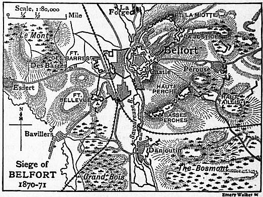
The old fortress consisted of the town enceinte, the castle (situated on high ground and fortified by several concentric envelopes), and the entrenched camp, a hollow enclosed by continuous lines, the salients of which were the castle, Fort La Justice and Fort La Miotte. These were planned in the days of short-range guns, and were therefore in 1870 open to an overwhelming bombardment by the rifled cannon of the attack. Denfert-Rochereau, however, understood better than other engineers of the day the power of modern artillery, and his plan was to utilize the old works as a keep and an artillery position. The Perches ridge, whence the town and suburbs could be bombarded, he fortified with all possible speed. On the right bank of the Savoureuse he constructed two new forts, Bellevue in the south-west and Des Barres to the west, and, further, he prepared the suburb on this side for a hand-to-hand defence. His general plan was to maintain as advanced a line as possible, to manoeuvre against the investing troops, and to support his own by the long range fire of his rifled guns. With this object he fortified the outlying villages, and when the Germans (chiefly Landwehr) began the investment on the 3rd of November 1870, they encountered everywhere a most strenuous resistance. Throughout the month the garrison made repeated sorties, and the Germans were on several occasions forced by the long range fire of the fortress to evacuate villages which they had taken. Under these circumstances, and also because of their numerical weakness and the rigour of the weather, the Germans advanced but slowly. On the 2nd of December, when at last von Tresckow broke ground for the construction of his batteries, the French still held Danjoutin, Bosmont, Pérouse and the adjacent woods, and, to the northward (on this side the siege was not pressed) La Forge. Thus the first attack of the siege artillery was confined to the western side of the river between Essert and Bavillers. From this position the bombardment opened on the 3rd of December. Some damage was done to the houses of Belfort, but the garrison was not intimidated, and their artillery replied with such spirit that after some days the German commander gave up the bombardment. On this occasion the distant forts La Miotte and La Justice fired with effect at a range of 4700 yds., affording a conspicuous illustration of the changed conditions of siege-craft. The German batteries, as more guns arrived, were extended from left to right, and on the 13th of December the Bosmont was captured, ground being also gained in front of Bellevue. The difficulties under which the siege corps laboured were very great, and it was not until the 7th of January 1871 that the rightmost battery opened fire. The formal siege of the Perches redoubts had now been decided upon, and as an essential preliminary to further operations, Danjoutin, now isolated, was stormed by the Landwehr on the night of the 7th-8th January. In the meanwhile typhus and smallpox had broken out amongst the French, many of the national guards were impatient of control, and the German trenches, in spite of difficulties of ground and weather, made steady progress towards the Perches. A week after the fall of Danjoutin the victory of von Werder and the XIV. army corps at the Lisaine, in which a part of the siege corps bore a share, put an end to the attempt to relieve Belfort, and the siege corps was promptly increased to a strength of 17,600 infantry, 4700 artillery and 1100 engineers, with thirty-four field-guns besides the guns and howitzers of the siege train. The investment was now more strictly maintained even on the north side. On the night of the 20th of January the French lines about Pérouse were carried by assault, and, both flanks being now cleared, the formal siege of the Perches forts was opened, the first parallel extending from Danjoutin to Haut Taillis. In the early morning of the 27th a determined but premature attempt was made to storm the Perches redoubts, which cost the besiegers nearly 500 men. After this failure Tresckow once more resorted to the regular method of siege approaches, and on the 2nd of February the second parallel was thrown up. La Justice was now bombarded by two new batteries near Pérouse, the Perches were of course subjected to an “artillery attack,” and henceforward the besiegers fired 1500 shells a day into the works of the French. But the besiegers were still weak in numbers and their labours were very exhausting. Bellevue and Des Barres became very active in hindering the advance of the siege works, and the German battalions were so far depleted by losses and sickness that they could often muster but 300 men for duty. Still, the guns of the attack were now steadily gaining the upper hand, and at last on the 8th of February the Germans entered the two Perches redoubts. This success, and the arrival of German reinforcements, decided the siege. The Perches ridge was crowned with a parallel and numerous batteries, which in the end mounted ninety-seven guns. The attack on the castle now opened, but operations were soon afterwards suspended by the news that Belfort was now included in the general armistice (February 15th). A little later Denfert-Rochereau received a direct order from his own government to surrender the fortress, and the garrison, being granted free withdrawal, marched out with its arms and trains. “The town had suffered terribly ... nearly all the buildings were damaged ... the guns in the upper batteries could only be reached by ladders. The garrison, of its original strength of 17,700 officers and men, had lost 4750, besides 336 citizens. The place was no longer tenable” (Moltke, Franco-German War). Nevertheless, “the defence was by no means at its last stage” at the time of the formal surrender (British Text-Book of Fortification, 1893). The total loss of the besiegers was about 2000 men.
See J. Liblin, Belfort et son territoire (Mülhausen, 1887).
BELFRY (Mid. Eng. berfrey, through Med. Lat. berefredus, from Teut. bergfrid or bercvrit, which, according to the New Eng. Dict., is a combination of bergen, to protect, and frida, safety or peace; the word thus meaning a shelter; the change from r to l,—cf. almery for armarium,—wrongly associated the origin of the word with “bell,” and aided the restriction in meaning), a word in medieval siege-craft for a movable wooden tower of several stages, protected with raw hides, used for purposes of attack; also a watch-tower, particularly one with an alarm bell; hence any detached tower or campanile containing bells, as at Evesham, but more generally the ringing room or loft of the tower of a church (see Tower).
BELGAE, a Celtic people first mentioned by Caesar, who states that they formed the third part of Gaul, and were separated from the Celtae by the Sequana (Seine) and Matrona (Marne). On the east and north their boundary was the lower Rhine, on the west the ocean. Whether Caesar means to include the Leuci, Treviri and Mediomatrici among the Belgian tribes is uncertain. According to the statement of the deputation from the Remi to Caesar (Bell. Gall. ii. 4), the Belgae were a people of German origin, who had crossed the Rhine in early times and driven out the Galli. But Caesar’s own statement (B.G. i. 1) that the Belgae differed from the Celtae in language, institutions and laws, is too sweeping (see Strabo iv. p. 176), at least as regards language, for many words and names are common to both. In any case, only the eastern districts would have been affected by invaders from over the Rhine, the chief seat of the Belgae proper being in the west, the country occupied by the Bellovaci, Ambiani and Atrebates, to which it is probable (although the reading is uncertain) that Caesar gives the distinctive name Belgium (corresponding to the old provinces of Picardy and Artois). The question is fully discussed by T.R. Holmes (Caesar’s Conquest of Gaul, 1899), who comes to the conclusion that “when the Reman delegates told Caesar that the Belgae were descended from the Germans, they probably only meant that the ancestors of the Belgic conquerors had formerly dwelt in Germany, and this is equally true of the ancestors of the Gauls who gave their name to the Celtae; but, on the other hand, it is quite possible that in the veins of some of the Belgae flowed the blood of genuine German forefathers.” W. Ridgeway (Early Age of Greece, 1901) considers that the Belgic tribes were Cimbri, “who had moved directly across the Rhine into north-eastern Gaul.” No definite number of Belgian tribes is given by Caesar; according to Strabo (iv. p. 196) they were fifteen in all. The Belgae had also made their way over to Britain in Caesar’s time (B.G. ii. 4, v. 12), and settled in some of the southern counties (Wilts, Hants and Somerset). Among their towns were Magnus Portus (Portsmouth) and Venta Belgarum (Winchester).
In 57 B.C., after the defeat of Ariovistus, the Belgae formed a coalition against Caesar, and in 52 took part in the general rising under Vercingetorix. After their final subjugation, Caesar combined the territory of the Belgae, Celtae and Aquitani into a single province (Gallia Comata). Augustus, however, finding it too unwieldy, again divided it into three provinces, one of which was Belgica, bounded on the west by the Seine and the Arar (Saône); on the north by the North Sea; on the east by the Rhine from its mouth to the Lacus Brigantinus (Lake Constance). Its southernmost district embraced the west of Switzerland. The capital and residence of the governor of the province was Durocortorum Remorum (Reims). Under Diocletian, Belgica Prima (capital, Augusta Trevirorum, Trier) and Secunda (capital, Reims) formed part of the “diocese” of Gaul.
See A.G.B. Schayes, La Belgique et les Pays-Bas avant et pendant la domination romaine (2nd ed., Brussels, 1877); H.G. Moke, La Belgique ancienne (Ghent, 1855); A. Desjardins, Géographie historique de la Gaule, ii. (1878); T.R. Holmes, Caesar’s Conquest of Gaul (1899); M. Ihm in Pauly-Wissowa’s Realencyclopädie, iii. pt. 1 (1897); J. Jung, “Geographie von Italien und dem Orbis romanus” (2nd ed., 1897) in I. Müller’s Handbuch der klassischen Altertumswissenschaft.
BELGARD, a town of Germany, in the Prussian province of Pomerania, at the junction of the rivers Leitznitz and Persante, 22 m. S.E. of Kolberg by rail. Pop. (1900) 8047. Its industries consist of iron founding and cloth weaving, and there are considerable horse and cattle markets.
BELGAUM, a town and district of British India, in the southern division of Bombay. The town is situated nearly 2500 ft. above sea-level; it has a station on the Southern Mahratta railway, 245 m. S. of Poona. It has an ancient fortress, dating apparently from 1519, covering about 100 acres, and surrounded by a ditch; within it are two interesting Jain temples. Belgaum contains a cantonment which is the headquarters of a brigade in the 6th division of the western army corps. It is also a considerable centre of trade and of cotton weaving. There are cotton mills. Pop. (1901) 36,878.
The district of Belgaum has an area of 4649 sq. m. To the north and east the country is open and well cultivated, but to the south it is intersected by spurs of the Sahyadri range, thickly covered in some places with forest. In 1901 the population was 993,976, showing a decrease of 2% compared with an increase of 17% in the preceding decade. The principal crops are millet, rice, wheat, other food-grains, pulse, oil-seeds, cotton, sugar-cane, spices and tobacco. There are considerable manufactures of cotton-cloth. The town of Gokak is known for its dyes, its paper and its wooden and earthenware toys. The West Deccan line of the Southern Mahratta railway runs through the district from north to south. Two high schools at Belgaum town are maintained by government and by the London Mission. The Kurirs, a wandering and thieving tribe, the Kamais, professional burglars, and the Baruds, cattle-stealers and highwaymen, are notorious among the criminal classes.
History.—The ancient name of the town of Belgaum was Venugrama, which is said to be derived from the bamboos that are characteristic of its neighbourhood. The most ancient place in the district is Halsi; and this, according to inscriptions on copper plates discovered in its neighbourhood, was once the capital of a dynasty of nine Kadamba kings. It appears that from the middle of the 6th century A.D. to about 760 the country was held by the Chalukyas, who were succeeded by the Rashtrakutas. After the break-up of the Rashtrakuta power a portion of it survived in the Rattas (875-1250), who from 1210 onward made Venugrama their capital. Inscriptions give evidence of a long struggle between the Rattas and the Kadambas of Goa, who succeeded in the latter years of the 12th century in acquiring and holding part of the district. By 1208, however, the Kadambas had been overthrown by the Rattas, who in their turn succumbed to the Yadavas of Devagiri in 1250. After the overthrow of the Yadavas by the Delhi emperor (1320), Belgaum was for a short time under the rule of the latter; but only a few years later the part south of the Ghatprabha was subject to the Hindu rajas of Vijayanagar. In 1347 the northern part was conquered by the Bahmani dynasty, which in 1473 took the town of Belgaum and conquered the southern part also. When Aurungzeb overthrew the Bijapur sultans in 1686, Belgaum passed to the Moguls. In 1776 the country was overrun by Hyder Ali, but was retaken by the Peshwa with British assistance. In 1818 it was handed over to the East India Company and was made part of the district of Dharwar. In 1836 this was divided into two parts, the southern district continuing to be known as Dharwar, the northern as Belgaum.