THE NORWEGIANS IN SCOTLAND. (continued 2)
Reading edition
The memory of the warlike life of heathenism is conspicuously preserved in Mainland by the many large barrows, or tumuli, which meet the eye on all sides. It is, indeed, certain that several of these—viz., what are called the “Picts’ houses,” which form in their interior stone chambers, covered by small flag-stones laid over one another—must be ascribed to the older inhabitants of the island; yet enough remain which we may with good reason attribute to the Norwegians and Danes. They are not, like those tumuli, or “cairns,” which are found most frequently in the north of Scotland, a mass of small stones heaped together without any filling-in of earth, but are formed, like our Scandinavian barrows, of earth thrown up to a very considerable height. As in Scandinavia, they are met with mostly on hills, and near the firths or seacoasts, whence there is an uninterrupted view of the sea. To the ancient Northman it was evidently an almost insufferable thought to be buried in a confined or remote corner, where nobody could see his grave or be reminded of his deeds. The greater chief a man was the more did he desire that his “barrow” should lie high and uninclosed, so that it might be visible to all who travelled by land and by sea. United with this desire to live in the memory of posterity, the Viking certainly also indulged the secret belief, that his spirit, or ghost, would at times arise from the barrow to look out upon that beloved sea, and to refresh itself, after the gloomy closeness of the grave, with the cool breezes which play upon its bosom.
Some of the largest and most prominent barrows in the Orkneys are found about the middle of Mainland. To the west of the deep fiord in the middle of the east coast, (formerly Örreðfjord “Aurriaðfjördr,” i. e. Trout firth, but now called Firth), and cutting its way northwards far into the land, is the before-mentioned Loch of Stennis, with its famous old Celtic stone circles. But the largest of these, which lies on the ridge of a naze, or promontory (from Old N. “Steinsness”), is encompassed by twelve considerable, and partly perhaps Norwegian or Scandinavian, barrows; amongst which two in particular, to the north-east and north-west of the circle, are distinguished by their size and circumference. As the Saga informs us that it was on Steinsnæs that the chief, Einard Klining, at the instigation of Erik Blodöxe’s daughter, Ragnhilde, killed her husband Jarl Haavard, it is not impossible that one of the last-named large barrows may be the jarl’s grave. At all events it is natural enough that the Norwegians should have had a predilection for being buried on that lofty promontory, which was regarded even by the earlier inhabitants of the island as a holy place, and had been adorned by them with a truly imposing circle of immense blocks of stone. Future excavations will doubtless more clearly show which of the barrows are really Norwegian; but this much is certain—that the naze, with the circle of stones and the surrounding barrows, as well as the view of the three immense monumental stones, placed erect in a semicircle on the opposite side of Loch Stennis, afford a prospect not only interesting to the antiquarian, but which must strike every beholder.
Here and there, on Mainland, we meet with graves of the heathen times, which are not at all uncommon in the Orkneys and Shetland Isles. They are, however, of much lower elevation than those previously mentioned, and in general rise very little above the surface of the soil. In some of these, as in Shetland, besides urns, containing burnt bones and ashes, bodies have at times been found that have been buried without being burnt; together with swords of the Scandinavian kind before described, heads of lances, daggers, and knives; as well as bone combs, bowl-formed brooches of brass, and various other ornaments, evidently of Norwegian workmanship.
Just as the barrows, or grave hills, in Mainland, indicate by their peculiar size that in the heathen times the island was the chosen place of assembly for the mightiest men in the Orkneys and Shetland Isles, so also do the monuments of the early middle ages show that it continued to maintain its former pre-eminence after heathenism had ceased. Farthest towards the north-west, in the parish of Birsay, (Birgisherað), are to be seen considerable remains of the old castle, inhabited in the most ancient times by the jarls. Near the coast lies the Island of Brough (Burgh) of Birsay, on which also are seen traces of fortifications that have served to protect the jarls’ castle on the side of the sea. In the neighbourhood of this castle, Jarl Thorfin built a church, called Christ Church, in which both he and Jarl Magnus were buried. The latter, however, being afterwards canonized, his body was taken to Kirkwall. In the twelfth century, Bishop Wilhelm, the first bishop of the Orkneys, had his throne in this church. In Orphir (“Orfjara”), on the south coast of the island, was another castle where the jarls usually dwelt, until, together with the bishops, they fixed their abode at Kirkwall.
This town, which lies close to an excellent harbour, and opposite the Island of Shapinsay, has for about seven hundred years been the capital of the Orkneys and the Shetland Isles. It seems, however, to have existed even earlier, as a village, or small trading place. Its name, “Kirkjuvágr” (“Kirkevaag,” Eng. Church-bay), since corrupted into Kirkwall, was derived from a church which stood there. The elevation of the town to be the residence of jarls and bishops took place in the twelfth century, after Jarl Ragnhild had built a large cathedral there, to which he caused to be conveyed the body of St. Magnus, the patron saint of the island, to whom the cathedral was consecrated. Thus the body of the saint effected for the town what its excellent harbour had not been able to accomplish. In the parish of St. Ola’, within the town, there was formerly also a church consecrated to St. Olaf, the patron saint of Norway, but it has long since been demolished.
The traveller cannot but dwell, when in Kirkwall, on the remembrance of the departed splendour of the island, as he views the proud ruins of the jarls’ castle, which, however, in its last form was not built till the fifteenth century, and of the bishops’ castle, in which King Hakon Hakonsön of Norway died on the 16th of December, 1263. But what is still more striking to him who has leisure to examine it thoroughly, is the magnificent Church of St. Magnus, incontestably the most glorious monument of the time of the Norwegian dominion to be found in Scotland. Only one other cathedral church in all Scotland, namely, St. Mungo’s, in Glasgow, has in its most essential parts escaped perfectly uninjured from the violent religious commotions produced by the Reformation. The annexed sketch (partly after a drawing by Billings) will, at least, better serve to convey an idea of the remarkable appearance of this cathedral than any detailed description. Its length is 230 feet, its breadth 55 feet, or, if the transepts be included in the measurement, 101 feet, and its height about 50 feet. The arched vaults of the nave rest on 28 pillars, of which the four, in particular, that bear the tower are distinguished by their size and tasteful forms.
According to the Orkneyinga Saga, Jarl Ragnvald, by the advice of his father Kol, made a vow to St. Magnus that he would build a splendid church in his honour, if he (Ragnvald) succeeded in gaining the mastery over the islands. He obtained the dominion of them in the year 1137, and immediately afterwards began to lay the foundation of St. Magnus’ Church. “At first,” says the Saga, “the work went on so rapidly that subsequently there was not done near so much in four or five years. Kol was the person who, in fact, defrayed the expenses of the building, and determined how everything was to be. But by degrees, as the work proceeded, the expenses became burthensome to the jarl, whose pecuniary means were much exhausted. He therefore asked his father what he should do? Kol advised him to alter the law by which, upon the death of the owners, the jarls had hitherto succeeded to all the allodial land in the islands, so that the heirs had to redeem it, which they found very hard. The jarl, therefore, summoned the inhabitants to a Thing, and offered to sell them their right of Udal, so that they should no longer be obliged to redeem it. The matter was easily arranged on both sides. The jarl obtained a mark for every acre throughout the islands, so that there came in money enough for the building of the church, which is very handsome.”
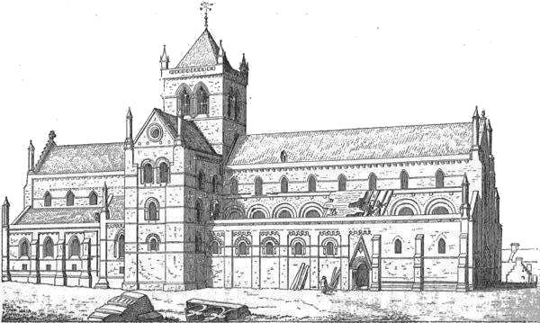
[++] St. Magnus’ Church
History, however, as well as the building itself, teaches us that the whole church, as it now stands, was by no means the work of Kol and Ragnvald. For, first, it is known that the pillars farthest towards the east and west, marked in the annexed ground plan with the faintest shade, belong to additions made at a far later period (viz., as late as the sixteenth century); and secondly, it is not even decided whether Kol and Ragnvald built the whole of the remaining part of the church, the transepts included, or whether they built only that part of the present choir which, from the two eastern pillars of the tower, comprises the six nearest pillars to the east, marked on the ground plan with the darkest shade. Between this last-named portion of the choir, which is undoubtedly the oldest part of the church, and the portion lying to the west, whose pillars on the ground plan have a rather lighter shade, there is a perceptible difference of style.
That zealous and skilful archæologist, Sir Henry Dryden, Bart., of Canons Ashby, to whom I am indebted for the original of the following ground plan, likewise did me the favour to give me, among several large drawings, a very excellent, but here very reduced, section of that part of the choir which is certainly known to have been built by Kol and Ragnvald. The section is taken from the middle of the nave, and represents a part of the northern side walls nearest to one of the pillars of the tower. It enables us to form an idea of the very considerable size of the church, and of the importance of Kol’s and Ragnvald’s labours, as well as readily to perceive in what style the church was originally built. This style, which in England is called the Norman, was indeed already somewhat obsolete in more southern districts at the time when St. Magnus’ Church was built; but it was quite natural that, so far northwards, it should be retained somewhat longer, especially as the architect was a native of the still more northern country of Norway.
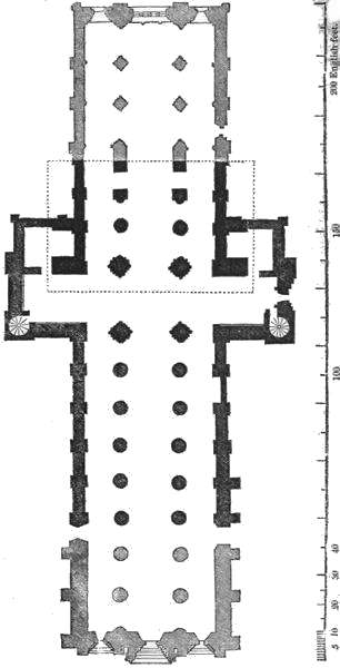
[++] St. Magnus’ Church - Floorplan
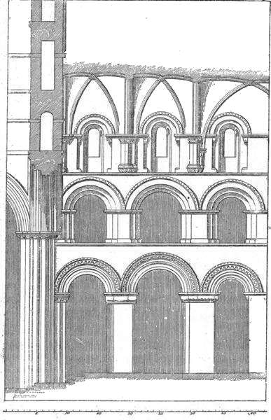
[++] St. Magnus’ Church - Interior
The next considerable portion of the cathedral which might possibly have been built by Kol and Ragnvald, or at least about their time, and which includes the transepts, the two western pillars of the tower, and the six pillars (three on each side) farther towards the west, has, indeed, like the very oldest part, round arches. But in these, as well as in the whole architecture, a much later style is clearly visible. It is, as we have said, doubtful whether this part of the church is also to be ascribed to Kol and Ragnvald. “Supposing that it is (says Sir Henry Dryden, in a letter accompanying the drawings), I explain the difference of scale and workmanship thus. Ronald began a church on a much smaller scale than the present St. Magnus. He became short of money, alienated seignorial rights in Orkney, got plenty of money, and went on with the church on a larger scale, and with better workmen than before. But (adds Sir Henry), though I spent eighteen weeks at the building, and have thought over the thing many times, I cannot make out the history of the building to my own satisfaction. There is no doubt that there is a great deal of copying in it; i. e., of building at one time in the style of an earlier one. In Scotland the semicircular arch is used in all styles, down to the year 1600.” In the additions made to St. Magnus’ Church to the east and west, in the sixteenth century, round arches are also found between the chief pillars.
In the winter of 1263-1264 the body of the Norwegian king Hakon Hakonsön was deposited in the cathedral; and somewhat more than twenty years afterwards the Norwegian princess Margaret (the maid of Norway), daughter of King Erik, the priest-hater, and of Margaret, daughter of the Scotch King, Alexander the Third, was buried in it. Upon the death of Alexander, her mother’s father, in 1289, Margaret, though only seven years of age, became queen of Scotland, but died in Orkney on her passage from Norway, in 1290. The cathedral naturally received the dust of most of the Norwegian jarls, bishops, and other mighty men, so long as the Norwegian dynasty lasted; but for their monuments we now seek in vain. By the alterations and rebuilding in the interior of the church they have all been long since destroyed.
For a Scandinavian, the church derives its greatest interest not only from the fact that it was founded, and partly built, by a Norwegian jarl, but more particularly from the circumstance that a Norwegian chief, the layman Kol, is expressly stated to have been the person “who was chiefly answerable for the building, and determined how everything should be.” For we thus find on the British Islands, and far towards the North, a manifestation of the same desire to build splendid churches and convents, which farther southwards, as for instance in Normandy, so vividly animated the Christian descendants of the emigrant Vikings. The oldest part of St. Magnus’ Church will, on a close inspection, show not a few resemblances to several of the nearly contemporary, but somewhat older, Norman churches in Normandy.
Section VIII.
Pentland Firth.—The Highlands.—Caithness.—Sutherland.—Fear
of the Danes.
The Orkneys are separated towards the south from the most northern part of the Scotch Highlands by a firth about eight miles in breadth, called Pentland Firth (Old N., Petlandfjörðr, the fiord of the land of the Picts?). The maelstrom, or whirlpool, in this firth, where the currents from the North Sea and Atlantic Ocean meet, is at least as violent and dangerous as the “Röst,” so famed in ancient times, between the Orkneys and Shetland. Even in calm weather the meeting currents raise the waves to an astonishing height, so that at times the whole firth is one sheet of white foam. If it happens that the current runs hard against the wind, or if a severe storm blows, it would not be advisable for any vessel to venture out into the firth. In the gales of winter, particularly from the north-west, the sea rises to such a height where the huge swell of the Atlantic is inclosed between the Orkneys and Scotland, and beats against the coast with such force, that the foam is driven far into the country, even over cliffs that stand more than four hundred feet above the sea! The Island of Stroma (Old N., “Straumsey”), which has obtained its name from the current, lies about the middle of the firth; and by the eastern entrance of it are the Islands of Pentlandskerries (Old N., “Petlandsker;” or Danish, “Pentlandskjære;” Eng., sunken rocks off the Pentland Firth), near which the waves form whirlpools that are still called by the inhabitants “Swelchies” (or Svælg: Old N., “Svelgr;” Eng., gulf).
The old Sagas, indeed, expressly point out the dangers of the Pentland Firth. Thus, when Olaf Trygvesön came from the West to the Orkneys with the intention of Christianizing the islands, he was obliged to run into the harbour of Asmundarvág (now Osmondwall) in the south of Hoy, because Pentland Firth was not navigable; and on the return of King Hakon Hakonsön from the Hebrides in 1263, one of his ships was lost in the Röst, and another escaped only with the greatest difficulty. Nevertheless the ancient Norwegians and Danes navigated this dangerous firth regularly, and do not seem to have considered it as forming any real boundary between the Orkneys and Scotland. At an early period the Norwegians had settled themselves along the south coast of the Pentland Firth, and founded colonies there which soon became so preponderatingly Norwegian that they might almost be regarded as inseparable parts of the Orkney jarldom. On this account the two most northern counties of Scotland, both of which united originally bore the Gaelic name of Catuibh, are still called after the original Norwegian forms, “Caithness” (Old N., “Katanes,” the naze of Catuibh) and “Sutherland” (Old N., Suðrland), or the land in the south; that is, as regards the Orkneys. It would be perfectly inexplicable, in any other way, why the north-western part of Scotland should be called the south land, or Sutherland. It is, moreover, a remarkable proof of the Norwegian origin of these names, that even the present Gaelic inhabitants do not adopt them, but always call Sutherland, after the old fashion, “Catuibh.” For the sake of distinction, however, they call Caithness “Gallaibh,” or the stranger’s land, because so many Norwegians immigrated to, and settled in, that county in preference to Sutherland.
The district of Caithness, or, as it was often called in ancient times, “Næsset,” forms a real naze, shooting out into the sea in a north-eastern direction. Its farthest point towards the north-east is called Duncansby Head (formerly “Dungalsnýpa”), from the neighbouring Duncansby (formerly “Dungalsbœr”). The broadest bay on the north coast trends in between the promontories of Dunnet Head and Holburn Head; the latter of which, by protecting Thurso Bay from western and north-western gales, renders it a tolerably good harbour, in a place where good harbours are scarce on this northern coast. Supposing, now, that we land in the Bay of Thurso, by the town of that name, we soon discover the outlet of the rivulet called Thurso Water (Old N., “Þorsá,” or Thorsaa, Thor’s rivulet), which has given the easily-recognised Scandinavian name both to the town and bay. The town and its immediate environs afford a great number of Norwegian memorials. The Norwegian king Eistein imprisoned the Orkney jarl Harald Maddadsön in Thurso itself. Close to the eastern side of the town stands a more recent monument, “Harald’s Tower,” erected over the body of Jarl Harald, who fell there in a battle in 1190. Not far from thence is the mansion called Murkle (formerly “Myrkhóll”), where, in the tenth century, Ragnhilde, the daughter of Erik Blodöxe and of Gunhilde, caused her husband, Jarl Arnfin, to be murdered. Immediately to the west of the town, near Scrabster (“Skarabólstaðr”), are to be seen the ruins of the palace formerly inhabited by the bishops of Caithness and Sutherland. In the twelfth century Bishop Ion was blinded and mutilated there, at the instigation of Jarl Harald. Five miles west of Scrabster, and close by a foaming waterfall, stands the mansion of “Forss,” by the river Forss Water. The rivulet called Thorsaa runs through a valley in ancient times called Thorsdal (“Þórsdalr”), adjoining another valley “Kálfadalr,” or Calf-dale (either the present Calder or Cuildal), in which Jarl Ragnvald was attacked and killed by Thorbjörn Klærk. In the “Dales of Caithness” (probably near Dale and Westdale, by Thurso Water) a battle was fought in the tenth century between Jarls Ljot and Skule, in which the latter fell.
Similar memorials present themselves everywhere on the promontory, with the exception, however, of the most western and more mountainous part, adjoining the frontiers of Sutherland. This district is still inhabited by a Gaelic population, the remnant of the ancient inhabitants, as is sufficiently testified both by the Gaelic names of places and the Gaelic language of the people. In Caithness, as well as everywhere else in the British Isles, it has been the fate of the Gaels or Celts to be driven to the poor and mountainous districts, whilst more fortunate strangers have taken possession of the fertile plains. The whole of the northern and eastern part of Caithness is a rather flat and open country, over which the sea wind sweeps freely without being intercepted by woods. Fertile and well-cultivated arable land is mingled with heaths, marshes, and small lakes. Wherever the soil is capable of cultivation, both on the coasts and in the interior, a great number of undoubted Norwegian names of places are still found scattered about, of the selfsame form as those in Orkney and the Shetland Isles: as, for instance, those ending in toft (as Aschantoft, Thurdystoft, formerly “Þorðarþupt”) seter (“setr”), busta, buster, or best (originally “bolstaðr”); but particularly in ster (staðr). The bays, which are mostly small and narrow, are generally called goe (from “gjá,” an opening). The larger ones are called wick (Viig); whence the town of Wick, the most important hamlet in Caithness, derives its name; but they are never called, as in the islands lately mentioned, wall (“Vágr,” or “Vaag”). Here and there a mighty barrow lifts its head, and sometimes—as, for instance, near Barrowston, parish of Reay—so extremely near the coast of Pentland Firth, that the spray washes over it. In general we shall not be mistaken in imagining that we have found in such barrows the last resting-places of the daring Vikings, who, not even in death, could endure to be far separated from the foaming maelstrom.
At times the common people dig up in these mounds pieces of swords and various kinds of ornaments, especially the peculiar bowl-formed brooches, of a sort of brass, which are very frequently discovered in the Scandinavian North, and particularly in the Norwegian and Swedish graves of the times of the Vikings. These are never found in England; and in Scotland they are discovered only in the Orkneys and Sutherland, as well as in some of the Western Islands, where the Norwegians also settled.
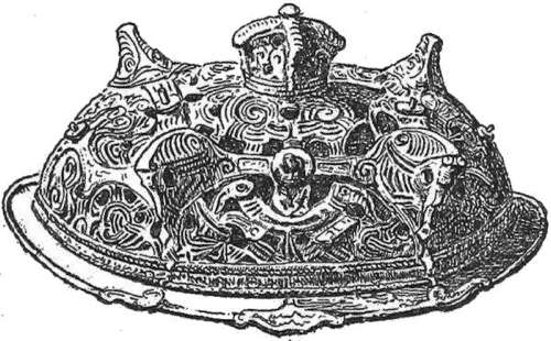
[++] Brooch
Tall bauta stones are to be seen in several places in Caithness, to which some legend about “the Danes” is generally attached; they now stand in a leaning position, as if mourning over the departed times of the heroic age. A monument of a somewhat later period, according to tradition that of a Danish princess, who suffered shipwreck on the coast, was also formerly to be found in a churchyard near Ulbster. Danish fortifications, consisting partly of square towers, once existed along the coast, principally near the navigable inlets; but these also have now, for the most part, disappeared.
With several intervals, Caithness was subject to Norwegian jarls until some time in the fourteenth century, or for about as long a period as Orkney and the Shetland Isles. After that time, however, it does not seem to have been oppressed to such a degree as those islands; which circumstance, in conjunction with the originally great number of Norwegian settlements in the country, is the cause that even in the present day we are not referred only to inanimate memorials of the ancient Norwegian population. The present living inhabitants bear a decided and unmistakable impress of their Norwegian descent. The language in the plains of Caithness, and in the open valleys, is the same dialect of the English as is spoken in Orkney and the Shetland Isles, because the transitions from Norwegian to English have been the same. The people have in some parts, as in the parish of Wick, pure Scandinavian names: Ronald (Ragnvald), Harold, Swanson (Svendsen), Manson (Magnuson), and others; and their tall and personable figures, as well as their light hair and broad faces, render them a striking contrast to the shorter and more swarthy Highlanders. As the descendants of an old Gaelic and of an old Norwegian population adjoin one another in Caithness, we have an excellent opportunity of observing, on a small scale, how the Norwegians and Danes have actually implanted in the British Isles a more seafaring spirit and greater nautical skill. Even to the present day the Gael, in Caithness, as well as throughout the Highlands, has a decided aversion to the sea, nay, a downright fear of its dangers. It is pretty well known that in general, and except on the most urgent necessity, one should not venture out into the Pentland Firth in boats steered and rowed by Gaels or Highlanders; for, in the event of a storm, all steady command is speedily lost, and gives place to anxious irresolution. The descendants of the old Norwegians, on the contrary, who are familiar with the sea from childhood, and amongst whom lies Wick, the most important fishing station in Scotland, show themselves precisely in the hour of danger the worthy sons of their forefathers, the ancient Vikings. It is only the man at the helm who speaks, and he gives his orders in a few decisive words. He is punctually obeyed, and the misfortune is said to be rare, if his coolness, joined to his knowledge of the sea and its currents, do not gain the victory over the violence of the storm and the turbulence of the billows. This seafaring population of Caithness do not, like the Highlanders, disdain to resort to fishing, in order to bring home the riches of the sea. As their soil, moreover, is by no means barren, and as they have naturally greater activity and more inclination to work than the Highlanders, as well as, through their English dialect, greater facility in their traffic with the more southern districts, it is not to be wondered at that the prosperity of Caithness manifests a great and constant progress. We may even justly assert that the descendants of the Norwegians in Caithness are in a far more fortunate situation than their kinsmen in the Orkneys and Shetland Isles.
In ancient times, a Norwegian population speaking its native language, was undoubtedly spread over the whole eastern coast of Caithness, as well as over several districts of Sutherland. But the English language, which in our times has superseded the Norwegian, ceases to be the common language of Caithness immediately to the south of the parish of Wick. A line drawn from Clyth Ness, in a north-western direction to the before-mentioned mansion of Forss to the west of Thurso, will indicate, as near as may be, the boundary between Gaelic and English. If, however, we travel southwards from the parish of Wick, through the parish of Latheron, where the common language is already Gaelic, we, nevertheless, pass a great many villages and farms bearing Norwegian names; as, for instance, Lybster and Forse (by a waterfall). The mountains here begin to be higher, and to stand closer and closer together towards the sea. At length, after passing the deep valley of Berrydale (Old N., “Berudalr”), and the beautiful wood-crowned banks of its river, we ascend the steep mountain ridge called “the Ord of Caithness,” which runs boldly out into the sea, and forms a natural boundary between the narrow projecting promontory of Caithness and the broader Sutherland.
The first large valley in Sutherland to the south of this mountain ridge is Helmsdale, which is watered by a river of no mean size. That Helmsdale is a Norwegian name (in the Sagas “Hjalmundsdalr”) is at once evident from the present Gaelic inhabitants calling the valley in pure Gaelic, “Strath Ullie,” or with a strange confusion of language, Strath Helmsdale; for as Strath signifies in Gaelic a valley or dale, the word dale is added both at the beginning and end. It is a similar repetition which we so often hear when the “Orkney Isles” are spoken of, in the original language “Orknö,” but which, translated as now used, is Orknö Öerne (or the “Orkney-islands-islands”). Along Helmsdale River several places are met with whose original Norwegian names are still to be discerned; as, for instance, Eilderabol, Gilaboll, Dviaboll, and Leiraboll. All these have the ending bol, which is peculiar to a number of Norwegian names of places in Sutherland and in some of the Hebrides; but which, in Caithness, the Orkneys, and Shetland Isles, as well as in Lewis and several of the Hebrides, appears in the longer form of “bolstaðr.” To the north-west of Helmsdale are the vales of Kildonan, which run up as far as the Vale of Strathmore in Caithness. Here, it is supposed, on the frontiers of Caithness and Sutherland, lay “Eisteinsdalr,” so famed in history as the spot where the Scotch king William encamped in the year 1198. It is, however, very uncertain whether “Easterdale” in Strathmore be in any way connected with the name of Eisteinsdal.
On leaving Helmsdale the coast opens, and fertile and beautiful fields begin to expand themselves. Past Midgarty and Wester Gartie (the middle and western Gaard, or farm, from Old N. “garðr”?) the road runs along the shore of the Bay of Dornoch (an arm of the “Breidifjördr,” or broad firth mentioned in the Sagas, in which the Moray Firth is also included) to the little village of Brora, which is built on a considerable river, and where for a long period the only large bridge in Sutherland was to be found. It was possibly from this circumstance that the Norwegians gave the village its name (“Brúrá,” the bridge rivulet). A river in Iceland is also still called Brúrá, from a bridge which crosses it. The ancient seat of the Earls of Sutherland, Dunrobin (Robin’s tower, from dun, a tower), lies on the seashore, in the neighbourhood of Brora, surrounded by fine corn-fields and considerable tracts of woodland. The latter, however, were planted at a recent period. In the background rise considerable mountains, covered with heath. In this place, so highly favoured by nature both as regards scenery and fertility, the Norwegian jarls who ruled over Sutherland undoubtedly had one of their chief residences; as, for instance, Sigurd Jarl, a brother of Ragnvald Möre-Jarl, Sigurd the Stout (+ 1014), and his son Thorfin (+ about 1064). Norwegian antiquities, like those discovered in Caithness, are found in graves near Dunrobin, particularly the well-known bowl-formed brooches or buckles. In the neighbourhood several places with Norwegian names can be pointed out; for instance, just south of Dunrobin, in the fertile valley by the river Fleet, Mickle Torboll and Little Torboll (from Thor and bol); and on the coast, Skelbo, Skibo, and Embo (from bol, or perhaps more correctly from bœr, bö). Sigurd, the first conqueror of Sutherland, is said to have extended his dominion as far as Ekkjalsbakke. As bakki in the ancient language signifies the bank of a river, there cannot be the least doubt that Ekkjal is the river Oykill, which still forms the southern boundary of Sutherland. Sigurd himself is said to have been interred at Ekkjalsbakke. He gained the victory in a foray over the Scotch jarl Melbrigd, and cut off his head, which, in the overweening pride of his triumph, he hung to his saddle; but a sharp tooth that projected from the head chafed his leg, and caused a wound which proved his death. On different parts of the banks of the Oykill numerous barrows are seen, indicating the many battles that have been fought in ancient times on the frontiers of Sutherland. But nobody is able to point out the barrow of Sigurd Jarl; the tradition relating to it has vanished with the Norwegian population.
For the rest, names of places prove that the Norwegians had also settled themselves along the coast to the south of the Oykill. On the narrow naze called Tarbet Ness, between Dornoch and Cromarty Firths, are the villages of Arboll and Wanby, as well as the town of Tain, whose Gaelic name, “Bailed Dhuich” (or St. Duthus’ Town), shows at once that “Tain” must be of foreign origin. Tain is, moreover, a corruption of “Þing,” a Thing; and in like manner the somewhat considerable town of Dingwall, at the extremity of Cromarty Firth, was originally called “Þingavöllr,” or Thingwalla; whence the remarkable fact is evident, that the Norwegians were once sufficiently numerous in these districts to have both an inferior Thing (Tain) and a superior one (Dingwall). Dingwall, like Tain, besides its original Norwegian name, has also the Gaelic one of Inverphaeron. As the Norwegians, therefore, must have permanently possessed considerable tracts in these districts, it is clear that their settlements on the east coast of Scotland must have extended quite down to Inverness-shire and Moray. The before-mentioned stronghold of Burghead in Moray, which the Northmen maintained to the last extremity, lies pretty close to the east of Cromarty Firth, the inlet to Dingwall.
As the Norwegian language and other Norwegian characteristics have given way to the Gaelic tongue, manners, and customs, in the former Norwegian districts on the north coast of Scotland, from Clyth Ness in Caithness to Dingwall on the Firth of Cromarty, we can scarcely be surprised that the north coast of Sutherland, whose rocks and heaths offered much fewer allurements to the Norwegians than the fertile valleys and plains of the east coast, and which were therefore far less colonized by them, should have preserved distinct traces of these foreign conquerors only in a few names of places. A remarkable instance of the Gaelic language having expelled the Norwegian is to be found immediately on the borders of Caithness, in the valley of Halladale. In a river there are two waterfalls, of which the uppermost is called Forsinard, and the lower one Forsindin. In both these names the Norwegian “Fors” is not to be mistaken; but Gaelic terminations have in later times been added by the Gaels, so that Forsinard now signifies the upper Fors, and Forsindin the under, or lower, Fors. Halladale is likewise frequently called by the additional Gaelic name of Strath—“Strath Halladale.”
This much, however, is clear, that the whole of the north and west coast of Sutherland was once colonized by Norwegians. Besides various names of places west of Halladale, which likewise end in dale, such as Armadale, Swordale, and Torrisdale, it is surprising that we should still meet with pure Norwegian names on four of the largest firths of the north-west of Sutherland; viz., on the north coast the “Kyle of Tongue” (from “túnga,” a tongue of land, a naze), together with the adjoining village, Kirkiboll (Kirkebolet); further, Loch Eriboll, with the large farm of Eriboll (the bol on the Eir, or tongue of land, from the Old N. “eyri”); the Kyle of Durness, or Dyrnæs, with the bol, or dwelling, of Crossboll; and lastly, on the west coast, not far from Cape Wrath, Loch Laxford (Laxfjorden, or the Salmon Firth; Old N., “Laxafjörðr”). “Loch” is the Gaelic name for a lake or firth, and consequently, in Loch Laxford, expresses tautologically the existence of a fiord or firth; just as the name “valley” is twice expressed in Strath Helmsdale and Strath Halladale. The last three of the above-mentioned firths seem to have been of much importance to the Norwegians. There is an excellent harbour in Loch Eriboll, which is still frequented by numerous ships. The neighbourhood round Loch Durnes afforded excellent opportunities for hunting the deer, particularly on Durnæs itself, which extends between Loch Durnes and the Atlantic up to Cape Wrath (Old N., “Hvarf”), and which, still later in the middle ages, was celebrated for its excellent deer. Loch Laxford, which obtained its name from the salmon (Lax) in the river and at its mouth, is commonly known to the present day as one of the rivers in Scotland most abounding with that fish. Several isolated rocks in the sea by the coast of Sutherland are called, as in the Shetland Isles, “stacks;” and in several names of islands we meet with the Scandinavian sker or skjær; such as Skerroar (Skjæröerne, the rock islands); and in Loch Eriboll, Dhusker, Skerron, and others. A little island near the middle of the west coast is called Calva (Old N., “Kálfey,” or the Calf Island), a name frequently given by the Northmen to small islands that lay in the neighbourhood of a larger one (for instance, the Calf of Man). For the rest, Calva is one of the last decidedly recognisable Scandinavian names of places on the west coast of Sutherland. The real Norwegian population evidently ceased at Laxfjord. Norwegian names of places are scarcely to be found on the coasts of the Highlands to the south of Sutherland. The country there was so wild, rocky, and remote, that foreign conquerors could only with the greatest difficulty have maintained a position against the Highlanders, who were always prepared to make sudden and dangerous attacks from the mountains in the interior. Aware of this, the Norwegians seem to have limited themselves, on the western shores of the Highlands, chiefly to the levying of provisions along the coast, and to the plundering of cattle and other property. Round about the mouths of the Highland firths are still to be seen the remains of old castles, which the Scotch kings, and particularly Alexander the Second, are said to have built, in order to prevent “the Danes” from making these devastating descents.
The memory of the conquests and predatory incursions of the Norwegians, or “Danes,” is still preserved in a remarkable degree among the poorer classes in Sutherland, as well as in the rest of the Scottish Highlands. Numberless traditions are in circulation respecting the levying of provisions by “the Danes;” and barrows, or cairns, are not unfrequently pointed out, in which a Scandinavian prince, or king’s son, killed by the natives whilst on some Viking expedition, is said to be buried. Besides the usual cruelties ascribed to the Danes in the traditions of the Lowlands, and of England, they are here accused, into the bargain, of having burnt the forests, and thus caused that want of wood which acts so injuriously on the climate of the Highlands. In proof of this it is adduced that roots and trunks of trees, sometimes perceptibly scorched, are discovered in the turf-bogs of the Highlands. It is not considered that similar discoveries are very common in other countries, as, for instance, in Denmark itself; where trunks of trees, especially firs, have been dug up, precisely as in the Scotch Highlands. They are the produce of vegetative processes in the pre-historical times; and the apparent scorching has been produced either by accidental fires, or more, probably, by the simple mode of felling trees in use among the aboriginal inhabitants of Europe; who, like certain savage tribes at the present day, for want of metal tools, were obliged to burn the trunks of trees which they wished to fell.
By way of amends, the Danes have now and then the honour of being regarded in the Highlands as having been the teachers of the natives. One of the first jarls of the Orkneys was, according to the legends, called by the name of Torf Einar, because he was the first who caused turf to be dug on a point of land (Torfnæs) in Scotland. This promontory, probably the present Tarbet Ness, was at all events either in Caithness or Sutherland; and it is certainly a remarkable coincidence, that the common people of that district still relate that “the Danes” taught them to burn turf. We likewise hear at times that “the Danes” taught the use of hand querns, or hand-mills; nay, even that the favourite national instrument of the Highlanders, the bagpipes, was originally introduced by the Danes. In short, if anything, whether good or bad, be of doubtful origin, it is frequently attributed to “the Danes.”
But it is peculiar to the north-western and most remote districts of the Highlands, that the common people still harbour no small degree of dread lest “the Danes” should return, and repeat their cruel devastations. About thirty years ago (according to J. Loch, “An Account of the Improvements on the Estate of the Marquis of Stafford,” London, 1820, 8vo.), English engineers were employed in measuring all the heights in Sutherland. This caused much sensation among the natives, who thought that these engineers were sent by the Danes to make maps and plans of the country, previously to the arrival of the Danish army. They imagined that the king of Denmark had an old feud with the Mackays, and that he was now coming to take a sanguinary revenge on the whole clan.
During my stay in Sutherland I had repeated occasion to convince myself not only that the fear of the Danes has not yet died away there, but also that tradition has connected with them things with which they had nothing whatever to do.
Close outside the town of Dornoch, on the east coast of Sutherland, there stands a stone pillar in an open field, which is simply the remains of one of those crosses so frequently erected, in Roman Catholic times, in market-places. As a matter of course, the arms of the jarls of Sutherland are carved on one side of the stone, and on the other are the arms of the town—a horse-shoe. Tradition, however, will have it that the pillar was erected in remembrance of a battle fought on this spot, in which the Jarl of Sutherland commanded against “the Danes.” In the heat of the battle, while the Jarl was engaged in personal combat with the Danish chief, his sword broke; but in this desperate situation he was lucky enough to lay hold of a horse-shoe that accidentally lay near him, with which he succeeded in killing his adversary. The horse-shoe is said to have been adopted in the arms of the town in remembrance of this feat. In the cathedral church of Dornoch is a carved stone monument of the middle ages, representing one of the ancient bishops who once resided in Dornoch. He also is said to have fallen in the same battle, but my authority, the person who showed me over the church, added:—“I am proud to tell that the Danes were defeated.”
Having employed myself in examining, among other things, the many so-called “Danish” or Pictish towers on the west and north-west coast of Sutherland, the common people were led to believe that the Danes wished to regain possession of the country, and with that view intended to rebuild the ruined castles on the coasts. The report spread very rapidly, and was soon magnified into the news that the Danish fleet was lying outside the sunken rocks near the shore, and that I was merely sent beforehand to survey the country round about; nay, that I was actually the Danish King’s son himself, and had secretly landed. This report, which preceded me very rapidly, had, among other effects, that of making the poorer classes avoid, with the greatest care, mentioning any traditions connected with defeats of the Danes, and especially with the killing of any Dane in the district, lest they should occasion a sanguinary vengeance when the Danish army landed. Their fears were carried so far that my guide was often stopped by the natives, who earnestly requested him in Gaelic not to lend a helping hand to the enemies of the country by showing them the way; nor would they let him go till he distinctly assured them that I was in possession of maps correctly indicating old castles in the district which he himself had not previously known. This, of course, did not contribute to allay their fears; and it is literally true, that in several of the Gaelic villages, particularly near the firths of Loch Inver and Kyle-Sku, we saw on our departure old folks wring their hands in despair at the thought of the terrible misfortunes which the Danes would now bring on their hitherto peaceful country.
Section IX.
The Hebrides.—The Northern Isles: Lewis and Harris; (Næs);
Skye.—Ossian’s Songs.—Iona.
The rocky western coast of the Highlands south of Sutherland was not, as I before mentioned, permanently inhabited by the Norwegians. They had, indeed, regular settlements on the west coast, but these were on the islands. They were here secure from the sudden attacks of the Gaels, or Highlanders, who, generally speaking, would scarcely have ventured out on a sea which then swarmed with Vikings. The farther, therefore, the islands were from the mainland, so much the more secure would the Norwegian settlers be, and so much the greater, in effect, did their colonies become. By degrees they settled themselves on all the islands along the west coast, from Lewis to Man, which they called under one name, “Suðreyjar,” or the southern islands, from their situation with regard to the Orkneys and Shetland Isles. Sometimes, however, they did not reckon Man among them, and then divided the rest of the islands into two groups, in such a manner, that only the islands to the south of Mull were called “Suðreyar,” whilst Mull itself, and the islands to the north, obtained the name of “Norðreyar.” The Irish, and the rest of the Gaels, on the contrary, after the conquest of the islands by the Norwegians, called them “Inis Gâl” (the foreigners’ isles).
The most northern and largest of the northern isles was the extensive one which forms the present Lewis and Harris (the “Ljóðhus” of the Sagas). It is separated from Scotland by the broad, stormy, and troubled channel called the Minch. The southern part of it only, or Harris, where the mountains reach the height of between two and three thousand feet, can be called mountainous, for the rest of the island is rather flat, devoid of wood, and covered with heaths and moors. Some good arable land is, however, to be met with here and there along the coasts. Even in very early times this island was very densely inhabited by the Gaels, of which, among other things, some immense rows of stones, near Callernish, bear witness. In like manner, the Norwegians must, at a later date, have had considerable colonies in it. On this head we must not, of course, implicitly rely on the numerous traditions related by the common people about the landing of “the Danes,” their rising power, and subsequent overthrow. But, what is more certain, the names of not fewer than about ten large lakes in the island still retain the Norwegian termination vat (“vatn,” Vand, water); and three of the largest are called Loch Langavat (the long water). Several coves (Vige) in Harris are called vagh (“vagr”); as Groesavagh, Flodavagh; and in Lewis wick, as Sandwich (Sandvig; Eng., Sand-bay), and Norwich (Nordvig; Eng. North-bay). To these may be added a great number of Norwegian names of places ending in stra or sta (staðr, stead); as Little Scarristra, Meickle Scarristra (Harris); Erista, Mangersta (Lewis); in bost (bolstaðr), as, in Harris, Nisibost, Hagabost, Chillibost; and in Lewis, Callbost, Habost, Luirbost, Crossbost, Melbost, Garrabost, and others (in all about thirteen). Further, we find such names as Laxay (Laxá, Laxaa; Eng., Salmon river), Laxdale, Nether Holm and Upper Holm, Tong (túnga), &c. These Norwegian names of places are met with as well towards the south and west as on the east coast, where they are most numerous about Loch Seaforth (Sæfjörðr), and in the vicinity of the little town of Stornoway. But they are chiefly concentrated at one point, the most northern in the island, in a district which still retains the pure Norwegian name of “Ness.”
On this Naze, or promontory, are the lakes Langavat and Steapavat; the valleys Dibidale, Eorodale, North Dell, and South Dell; the manors and towns Skegersta, Swainbost, Habost, Cross, and at the farthest extremity Oreby or Eoropie (“Eyribœr,” the town on the Eir or Naze?); with the adjacent headland of Raven, which may possibly have been called after Odin’s sacred bird. At all events, there is good ground for assuming, from these names of places, that the promontory had a pre-eminently Norwegian population, which, indeed, is unmistakably apparent even at the present day.
Throughout Harris and Lewis, for instance, the Gaelic inhabitants are small, dark-haired, and in general very ugly. But no sooner do we arrive at Ness, than we meet with people of an entirely different appearance. Both the men and women have in general lighter hair, taller figures, and far handsomer features. I visited several of their cabins, and found myself surrounded by physiognomies so Norwegian, that I could have fancied myself in Scandinavia itself, if the Gaelic language now spoken by the people, and their wretched dwellings, had not reminded me that I was in one of those poor districts in the north-west of Europe where the Gaels or Celts are still allowed a scanty existence. The houses, as in Shetland, and partly in Orkney, are built of turf and unhewn stones, with a wretched straw or heather roof, held together by ropes laid across the ridge of the house, and fastened with stones at the ends. The houses are so low, that one may often see the children lie playing on the side of the roof. The family and the cattle dwell in the same apartment, and the fire, burning freely on the floor, fills the house with a thick smoke, which slowly finds its way out of the hole in the roof. The sleeping-places are, as usual, holes in the side walls.
It is but a little while ago that the inhabitants of the Naze, who are said to have preserved faint traditions of their origin from Lochlin (called also in Ireland, Lochlan), or the North, regarded themselves as being of better descent than their neighbours the Gaels. The descendants of the Norwegians seldom or never contracted marriage with natives of a more southern part of the island, but formed among themselves a separate community, distinguished even by a peculiar costume, entirely different from the Highland Scotch dress. Although the inhabitants of Ness are now, for the most part, clothed like the rest of the people of Lewis, I was fortunate enough to see the dress of an old man of that district, which had been preserved as a curiosity. It was of thick coarse woollen stuff, of a brown colour, and consisted of a close-fitting jacket, sewn in one piece, with a pair of short trousers, reaching only a little below the knees. It was formerly customary with them not to cover the head at all. In a carefully compiled Scotch and English guide book (Anderson’s Guide, 1842) it is stated, that “The islanders of the northern part of Lewis, with their long, matted, and uncombed hair, which has never been restrained by hat or bonnet from flowing as freely in the wind as their ponies’ manes, and their true Norwegian cast of countenance, form living portraits of the ancient Norsemen. The other inhabitants are chiefly of Celtic origin.” The difference between the descendants of the Gaels and of the Norwegians is consequently so apparent that it is as striking to a Scotchman or an Englishman as to a Scandinavian.
It is said on the island that the inhabitants of Ness are more skilful fishermen and better sailors than the rest of the men of Lewis. However that may be, as a pretty numerous Norwegian population on it has long kept itself unmixed and distinct from the Gaels, it is not improbable that those men of Lewis who are related to have formerly harried Shetland, until they were entirely defeated in a great battle in Mainland, may have been inhabitants of Ness, who, after the custom of the ancient Norwegians, went on expeditions beyond sea, either to gain booty, or, more probably, to decide some old dispute by the sword. That men of Lewis, of Gaelic descent, who have never liked the sea, but, on the contrary, always feared it, should have ventured repeatedly, and in great numbers, so far as Shetland, altogether exceeds belief.
On the coasts of Lewis and Harris are several small islands, with still recognisable Norwegian names, such as Calvay (“Kálfey”), Pabbay (“Papey”), Skarpa (Skarpey), Scalpay (Skalpey), together with the places called Meathallybost, Bernera (Bjarnarey), and others. In the south-west there are three large islands in a row; North Uist, Benbecula, and South Uist (in the Sagas “Ivist”), where there are also evident traces of a Norwegian population. A small island to the west of North Uist is called Kirkibost (Kirkjubolstaðr); on Benbecula there are the lakes Loch Ollevate and Langavat, as well as the Vaage, or inlets, Uskevagh, Kenlerevagh, and Riavagh; and on South Uist there are likewise lakes and inlets called vat and vagh; to which may be added such names of places as Frobast, Kirkidale, Hillisdale, and lastly, a mountain called Heckla, probably from the well-known volcanic mountain in Iceland. In a bay in the middle of South Uist are the islands Calvay and Pabbay. There is still a great number of small isles on the coasts of these islands, whose names in a greater or less degree all betray their Norwegian origin; for instance, Grimsa (“Grimsey”), Barra (“Barey”), Lingay (“Lyngey”), Hellesay (“Hellisey”), Eriskay (“Eiriksey”), and others. The Norwegians must even have visited the little island of St. Kilda, which lies about eighty miles west of Lewis; at least, two of the often-mentioned and peculiarly Scandinavian bowl-formed brooches have been discovered on the island; one of them I have seen in the Andersonian Museum, in Glasgow. Similar brooches were also found, with a skeleton, in the island of Sangay, between Harris and North Uist.
To the east of North and South Uist is the large island of Skye (“Skið”), separated from the Highland mainland by a narrow sound (“Skiðsund”). Between its more northern part and the mainland, where the sea is broader, are the islands of Rona, Raasay (“Hrauneyjar”), Scalpa (“Skálpey”), Pabba (“Papey”), and Longa (“Langey”). Skye, towards the south, is remarkable for its numerous and lofty mountains, whose beautiful forms are visible at a great distance. Towards the north the island becomes gradually flatter and broader. In the west and north-west parts it is indented by deep firths, round which are to be found the most fertile districts in the island. The east coast, on the contrary, is not so capable of cultivation, as it has large tracts of moorland heath and sand. The Norwegians, therefore, advisedly chose to settle on the western and north-western firths, which, besides being more fertile, were not so exposed to the attacks of the Gaels as the eastern and south-eastern coast, which very nearly approach the mainland. Not a few Scandinavian names of places may be still clearly recognised near Loch Snizort, such as Scuddeburgh, Skabost, Braebost, and, near a waterfall, Forscachregin (the Norwegian Fors with a Gaelic termination). By Dungevan Loch are the inlets Kilmaluag and Altivaig, and the villages Husabost, Collbost, and Nisabost. By Loch Bracadale (the “Vestrifjorðr” of the Sagas) are Fors, Orbost, Collbost, and Eabost. By Loch Harporth, Carabost; and by Loch Eynort, Husedalebeg and Husedalemore; which latter, in a mixture of Norwegian and Gaelic, signify little and great Huusdal (Housedale); and, with a similar mixture, Ghionaforsenary. A little more inland is the valley of Tungadelebeg, where the Gaelic beg (little) is added to the Norwegian Tungadal.
From the frequent Gaelic terminations and corruptions of the Norwegian names, it is sufficiently evident that the Norwegian language has lost its former dominion in the island, and that the Gaelic has resumed its ancient pre-eminence. The western districts of Skye, as well as the previously-mentioned Norderöer, or northern islands, from Lewis to Barrahead (which last are often called under one name, “the Long Island”), are precisely those places in the Highlands where the Gaelic tongue is most unmixed, and where the greatest quantity of old Gaelic traditions and songs still survives among the people. It was here also, that a great number of the world-renowned songs of Ossian were first composed. It is true we no longer hear the people sing them, but there can nevertheless be scarcely any doubt, particularly if we regard the perceptible traces of the ancient metre in the Gaelic texts, that the so frequently and warmly disputed edition by Macpherson is really founded on ancient songs, although these may have been somewhat altered by lapse of time, and by a not very happy translation. They have quite a peculiar interest for the Scandinavian North, from the striking agreement in tone and spirit which they present to several of the songs of the Sagas and Edda. These last, again, afford a strong proof of the genuineness of those attributed to Ossian, since the songs of the Sagas and Edda, at the time when Macpherson published his Ossian, were either not at all, or but very imperfectly known, even in Scandinavia itself, not to speak of other countries. The real age of Ossian’s songs is very uncertain, and very difficult to discover; but this much is clear, that they indicate a lively intercourse between Alba (Scotland) and Lochlin (Scandinavia), long before the times of the Vikings, and previously to all historical accounts of connections between those countries. We cannot, however, venture to conclude from this that the Orkneys, or any other part of Scotland, were at so early a period inhabited by a Scandinavian people. That such a colonization should really have taken place before the time of the Vikings, which began at the close of the eighth century, there are not only wanting historical and archæological proofs, but likewise all internal probability.
Mull (“Myl”) is the largest of the most southern Norderöer, or northern islands, but it is not richest in memorials of the Northmen. In the narrow strait or sound (“Mylarsund”) which separates the island from the mainland, there lies straight before Tobermory, the most important place in the island, the little island of Calve (“Mylarkálfr”); and somewhat farther south of Tobermory, on a rivulet by the coast, are the ruins of the palace of Aros (from “árós;” Dan., Aarhus, the mouth of the rivulet or Aa), once frequently inhabited by the rulers of these islands, called “Lords of the Isles.” Another river in Mull, well stocked with fish, was formerly called Glenforsay (Monro, “Description of the Western Isles,” 1594), from the Norwegian “forsá” (Fosaa; Eng., Waterfall-river), to which the Gaelic glen has since been added. With the exception, perhaps, of Assapoll (from -bol), in the south-west, the island has no Norwegian names of places. Of such names, however, several are to be met with on the islands west of Mull, particularly on Coll (“Kóln”), where we find Crossapull, Gisapoll (from bol), Arnabost (-bolstaðr), and Balehough; and on Tiree, Tyrvist, together with Kirkapoll, Heylipoll, Vassipoll, and Crossipoll. In the bay formed by Mull, towards the west, are found many small islands with originally Norwegian names, such as Ulva (“Ulfey”), together with Soriby, Gometra (“Guðmundarey”), and Staffa (“Stafey”), so famed for its stalactic caverns.
But of all the Hebrides, none is more renowned than Iona (Ithona, “the Waves’ Island”), or Icolmkill, “the island with Columba’s cells,” which lies in the open Atlantic, near the south-west point of Mull. It is not distinguished either by size and fertility or by numerous and splendid ruins; it is now but an inconsiderable island, with some few remains of churches, conventual buildings, and ancient Christian sepulchral monuments. But about thirteen centuries ago it was the light of the western world; for, after St. Columba settled there, it became the central point whence Christianity diffused itself towards the east and north, over Scotland and the surrounding islands. Iona thus obtained such repute for sanctity, that it was said that a deluge which was to overwhelm Ireland, and the islands round about, would have no power to inundate it. Tradition adds, that, for this reason, the ancient Irish, Scotch, and Norwegian kings, besides many other chiefs and mighty men, both at home and abroad, chose Iona as their place of burial; and that at the commencement of the sixteenth century, no fewer than three hundred and sixty splendid stone crosses, or tombstones, were still to be found on the island, which, however, with some few exceptions, have now entirely disappeared.
According to an old description of the island, by Dean Monro (1594), there was to the north of the Scotch graves an inscription, which ran thus:—“Tumulus regum Norwegie,” or, “the tombe of the Kings of Norroway, in the quhilk tombe, as we find in our ancient Eriske cronickells, there layes eight Kings of Norroway, and also we find in our Eriske cronickells, that Coelus, King of Norroway, commandit his nobils to take his bodey and burey it in Colmkill, if it chancit him to die in the isles; bot he was so discomfitit, that ther remained not so many of his army as wold burey him there.” By the kings of Norway here mentioned we must of course understand only the kings of the Sudreyjar, or southern islands, and the Irish kings of Norwegian descent. It is in itself very probable that these kings often desired to be buried in Iona, where the first bishops of the proper Sudreyjar, “the bishops of the isles,” dwelt, and whose church of St. Mary was consequently the chief church in the islands. The tombs of the kings, however, can at present scarcely be pointed out with certainty; we only know that they must have been in the large and still visible burial-place consecrated to St. Oran. On this place there is likewise a little chapel consecrated to the same saint, which, according to the opinion of some, is of Norwegian workmanship—a point, however, which must be very doubtful.
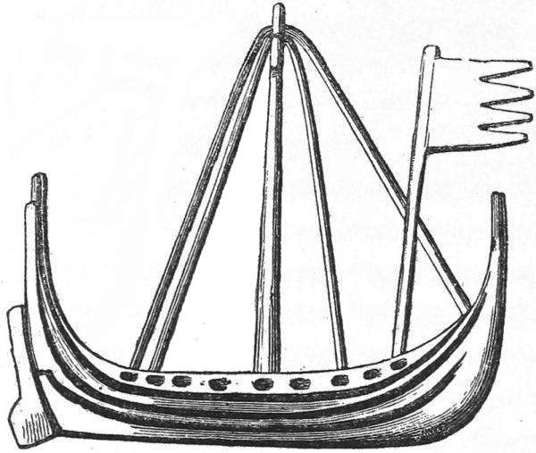
In the chapel are to be seen the remains of a carved monument erected in the year 1489 to Lachlan Mackinnon (Mac Fingon), and on it, underneath the inscription, is a ship, which is still to be found in the family arms of the Mackinnons, but which is said to have been originally the heraldic bearing of the Norwegian kings in the Isle of Man.
[++] Monument - Boat Decoration
The Island of Iona was of special importance in ancient times, not only to Scotland, but to the Scandinavian North. From it Christianity was assuredly disseminated among the Norwegians in the Sudreyjar, or southern isles, the Orkneys, and the Shetland Isles; whence, again, it was often carried by Vikings and merchants to Norway and Iceland. In the latter place, where not a few men from the southern isles were among the first colonists, there was even a church dedicated to St. Columba. Whilst, therefore, heathen Norwegians plundered and destroyed the churches and convents of Iona, the Christian Norwegians seem to have respected its sanctity. The Sagas, which call it “Eyin helga” (the holy island), state, that the Norwegian king, Magnus Barfod (Barefoot), when in his first expedition to the Sudreyjar and Ireland, in the year 1097, he came to “the holy island,” gave all the inhabitants a guaranty of peace and security, and allowed them to retain their possessions. It is also stated that “King Magnus opened the little Kolumkille Church, and went therein; but that he directly locked the door again, and said that no one should dare to enter; and since that time the church has never been opened.”
Section X.
The Sudreyjar, or Southern Isles.—Cantire.—Islay.—Man.—Names of
Places.—Runic Stones.—Kings.—Battle of Largs.—“Lords of the
Isles.”—Tynwald in Man.
Iona was not always accounted one of the northern isles. Farther towards the north, on the north-west coast of Mull, are the islands of Treshinish, and among them a steep rocky island, called Cairnburg, which is said to have formed, at all events at times, the boundary between the northern and southern isles, or Sudreyjar. Cairnburg is accessible only at one spot, and by its height above the sea it forms an important stronghold, which in former times was often numerously garrisoned. The Sagas, which call the island “Bjana,” or “Bjarnarborg,” state that it was one of those strong fortresses in the southern isles, the surrender of which was in vain demanded by King Alexander the Second of Scotland, from the Norwegian tributary king, Ion Dungadson; and tradition still tells that “the Danes” often fought for the possession of this important place.
“The Sudreyjar” (in which, among the larger islands, were included Colonsay, Oransay, Jura, Islay, Arran, Bute, the Cumbr Islands, and likewise the Peninsula of Cantire) are, strictly speaking, far from being so numerous as the northern islands; but in general they are distinguished from these by a richer and more fertile soil, which is the result of their more southern and more protected situation. This remark applies particularly to the charming islands of Arran (“Hersey”), Bute (“Bót”), and the Cumbr Isles (Kumreyar), which lie eastwards of the Peninsula of Cantire (“Satiri”), at the mouth of the Firth of Clyde; and which, together with the rocks, heaths, and moors of the Highlands, possess the woods and corn-fields of the Lowlands. They also enjoy a fine climate.
But although these last-mentioned islands were often under the dominion of Norwegian kings and jarls, they do not appear to have been inhabited by a settled Norwegian population; at all events, Norwegian names of places have disappeared from them. It is probable that they lay somewhat too near the hostile coasts of Scotland, and somewhat too far from the larger Norwegian colonies, for Norwegian settlers steadily to maintain upon them a position against the Gaels; nay, the Norwegian name, “Kumreyar,” the Cumbr Islands, seems to indicate that Cimri or Gaels dwelt upon them.
Names of places on the Peninsula of Cantire, on the contrary, where we find Smerbys (from by), Killipol (from bol), Torrisdale, and the pure Norwegian Skipness, but more particularly on the islands outside the Peninsula, near the west coast of Argyle, indicate a very considerable Norwegian colonization. Not only have several of the small islands Norwegian names, as Scarba (“Skarpey”) and Lunga (“Langey”), but the largest and most fertile of them, Islay (the “Il” of the Sagas), which Dean Monro as early as 1594 found to be fruitful, full of good pastures, abounding with large deer, having many forests, excellent hunting, and a river called Laxay (the pure Old N. “Laxá”) in which many salmon were caught (“with ane water callit Laxay, whereupon maney salmon are slaine”), still exhibits various traces of decidedly Norwegian settlements. On its east coast, as is usually the case with the Hebrides lying nearest to Scotland, few or no Norwegian names of places are found; but in the middle of the island is Nerby; by Loch Indal, Lyrabolls, Scarabolls, Conisby, Nerabolls, and Elister; and by a rivulet, Skeba (“Skipá;” Dan., “Skibeaaen,” or the ship rivulet); whilst on the west side of the island we find Olista, Culaboll, &c. This agrees very well with the accounts that the kings and jarls of the Sudreyjar of Norwegian descent had one of their chief residences in Islay; for it was quite natural that they should surround themselves with countrymen on whose courage and fidelity they could rely. The island abounds, moreover, in traditions and pretended memorials of “the Danes.” Near the bay of Knoch are two large upright stones, called “the two stones of Islay,” under which it is said that the Danish princess, Yula, after whom the island is named, lies buried. In various parts of the island are shown what are called “Danish” castles, encampments, and fortifications. It is also stated (see Anderson’s Guide), that there is a circular mound of earth on the island, with terrace-formed steps, which may possibly have once been used by the Norwegians as a Thing place, like a similar one in the Isle of Man.
The chief seat of the Norwegian power on the islands was, however, still more southward than Islay, namely, the Isle of Man (the “Mön” of the Sagas), which lies in the Irish Channel, to the south-west of Solway Firth, about midway between the coasts of Cumberland and Ireland. A peculiar dialect of the Gaelic tongue, called Manx, is spoken throughout this island, and the inhabitants have in general the same appearance as their Gaelic neighbours in Wales, Scotland, and Ireland. But no other of the western islands affords so many and such incontestable proofs of its having once had a very wide-spread Norwegian or Scandinavian population, who spoke their own language, and who, through a long series of years, must have been the predominant race.
The highest mountain in the island, which is about 2000 feet high, is called “Sneafell” (Norw., Sneefjeld; Eng., Snow-mountain). On the east side is the rivulet and town of “Laxey” (Laxaa); in the south-east is the long naze, “Langness.” To these may be added the bay called Derby Haven, which the Norwegians called “Rognvaldsvágr,” whence the neighbouring Ronaldsway derived its name. There are also the inlets of Perwick and Fleswick; the islands Calf of Man, Eye (Oë), and Holm, near the town of Peel; and, lastly, the villages Colby, Greenaby, Dalby, Kirby (Kirkeby), Sulby, and Iurby (formerly “Ivorby”—Ivarsby?), &c. The proportionately large number of names of places ending in “by,” which suddenly appear in Man, in contrast to the more northern islands, with their pure Norwegian names of places ending in “bol” and “bolstaðr,”—which, it must be observed, are not to be found on Man,—is a sort of proof that it received some colonists from the neighbouring old Danish Cumberland, by which means a mixed Norwegian-Danish population arose in the island.
The antiquary is much surprised to find on Man not merely one, but several of those runic stones, with genuine Scandinavian inscriptions, which he may have sought for in vain in England and Scotland. The different districts of the island contain altogether about thirty ancient sculptured monuments or sepulchral crosses; and of these at least thirteen have once had runic inscriptions, which in great part are still preserved. It is remarkable enough that these runic inscriptions are found exclusively in the more northern half of the island (at Kirk Andreas, two; at Kirk Michael, four; at Kirk Braddan, one; and at Kirk Onchan, five); whence we may, with some degree of probability, conclude that, at the time when these runic stones were erected, the Scandinavian language was the most prevalent one in the northern part of the island. The chronicles, indeed, state that the Norwegian, Godred Crovan, who conquered Man in the year 1077, retained the southern part of the island for himself and his followers; but the before-mentioned runic stones are certainly older than Godred’s conquest. The inscriptions on the stones have hitherto been copied and explained only in a very imperfect manner; but since casts in plaster have been taken of them, their interpretation has become incomparably easier and more simple. I have myself closely examined and compared them in two places (at Edinburgh, in the Museum of the Society of Scottish Antiquaries, and at Canons Ashby, in England, the seat of Sir Henry Dryden, Bart.); and I have since had an opportunity to renew my examination of all of them, in conjunction with the learned Norwegian professor, P. A. Munch, to whom I am indebted for several very important hints relative to their correct interpretation (amongst others that the rune ᚮ, which in most inscriptions signifies o, must in these always be read as b).
[++] Stones - Runic Inscriptions
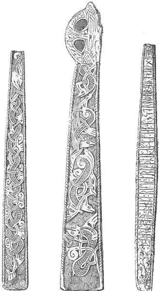
The annexed cut, after a plaster cast, represents one of the finest and best preserved runic stones in Man, namely, at Kirk Braddan, about the middle of the island.
The stone is fifty-seven inches high, eight inches broad at the base, and when the cross was whole, had a breadth of twelve inches at the top. Both its broad and one of its narrow sides are ornamented with serpents ingeniously interwoven, whilst the fourth side has the following runic inscription:
“Thurlabr Neaki risti krus thana aft Fiaks ... bruthur sun Jabrs.”
(“Thorlaf Neaki erected this cross to Fiak ... brother, a son of Jabr.”)
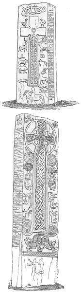
Another extremely well-preserved monumental cross, on which are carved various scrolls, animals, birds, and other things, such as horses, a stag, cows (?), swine, &c., stands in Andreas churchyard, and has the following inscription:—
“Sandulf ein suarti raisti krus thana aftir Arin Biaurg kuinn sina.”
(i. e., “Sandulf the Swarthy erected this cross to his wife Arnbjörg.”)
[++] Monument: Andreas Churchyard
(The drawing of this monument, as well as those of the following inscribed stones, is borrowed from W. Kinnebrook’s “Etchings of the Runic Monuments in the Isle of Man,” London, 1841, 8vo. But the faulty inscriptions in that book are here corrected.)
[++] Monument: Kirk Michael
In the middle of the village of Kirk Michael, close to the northern corner of the churchyard, is a stone not less richly sculptured than the preceding one, with all sorts of figures of stags, dogs, serpents, horses, horsemen, &c., which are placed round a large cross covered with interlacings, or scrolls. The inscription on it runs thus:—
“Jualfir sunr Thurulfs eins Rautha risti krus thana aft Frithu muthur sina.” (Or, “Joalf, son of Thorolf the Red, erected this cross to his mother Frida.”)
At the end of the inscription is carved the figure of a man (probably Joalf), with a shield on his arm and a lance in his hand. (See the annexed cut.)
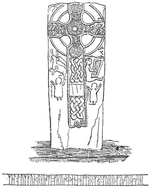
The language of the inscriptions, as well as the Scandinavian names which appear in them,—as Thorlaf, Arnbjörg, Frida, and particularly the names compounded after the genuine Scandinavian fashion, as Sandulf the Swarthy, and Thorolf the Red,—sufficiently prove that these monuments were erected by Northmen, or Norwegians, to their relatives who had died in the Isle of Man. A piece of runic stone in the wall of Michael’s Church bears the name of Grim the Swarthy (“Grims ins Suarta”); and in some similar fragments of inscriptions near Kirk Onchan we find the names of Thurid (“Thurith raist runir,” i. e., Thurith engraved runes) and Leif (“tra es Laifa fustra guthan son Ilan”). The well-known Scandinavian name, Asketil, is also found on the remains of a runic inscription in the museum in Douglas (“p. Askitil vilti i trigu——aithsaara siin;” i. e., whom Asketil deceived in security, contrary to his pledge of peace). At the same time, however, we may infer from names like Neaki, Fjak, and Jabr, that the Northmen must, when these inscriptions were written, have already mingled with the original Gaelic inhabitants of Man. A stone at Kirk Michael, which is ornamented with a finely sculptured cross, on the sides of which are seen a stag, a dog, a harper, and two figures apparently in an attitude of prayer, has a Norwegian inscription with purely Gaelic names, such as Mal Lumkun and Mal Muru:—
“Mal Lumkun raisti krus thana eftir Malmuru fustra sin...;” (i. e., “Mal Lumkun erected this cross to his foster father Malmor.”)
[++] Monument
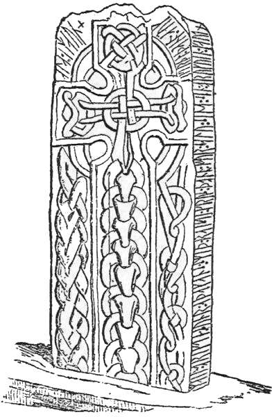
Some hitherto inexplicable fragments of inscriptions at Kirk Onchan may also possibly contain Gaelic words. The Manx runic stones bear, both in form and workmanship, a striking resemblance to the previously-mentioned sculptured monuments in the Lowlands, and on the north-east coasts of the Highlands. Yet several of the Manx stones exhibit certain peculiarities; as, for instance, the singular scale-covered serpents surrounded with interlacings, which do not appear in a similar form on the Scotch monuments. But as these serpents and interlacings very much agree with ornaments on different antiquities of the heathen times found in Scandinavia, and, as the language of the runic stones is pure Scandinavian, there is every reason to conclude that the splendid specimens on Man were carved by Norwegians, who, though they imitated the monuments in vogue in Scotland, frequently allowed their own characteristically fantastic ideas to display themselves in peculiar devices. This view is confirmed in a remarkable manner by a few Manx runic inscriptions, the real interpretation of which was first given by Professor Munch. On the stone at Kirk Michael, represented below, is the following inscription:—
“Mail Brigdi sunr Athakans smith raisti krus thana fur salu sini sin brukuin Gaut girthi thana auk ala i Mann.” i. e., “Malbrigd, son of Athakan (the) Smith, erected this cross for his soul.... Gaut made this (cross) and all on Man.”
According to this, Gaut, who, to judge from the name, was a Norwegian, erected all the crosses which, it must be observed, were at that time on Man. Another inscription perfectly agreeing with this, though taken from a very much defaced and broken monument near Kirk Andreas, on which has been carved a cross with many scrolls (delineated in Kinnebrook’s work, No. 8), runs as follows:—
“... thana af Ufaig fauthur sin in Gautr girthi sunr Biarnar ...” “(N. N. erected) this (cross) to his father Ufeig, but Gaut Björnsön made it.”
Gaut’s surname, here given, further proves his Norwegian, or Scandinavian, descent. From the language and manner of writing in the Manx inscriptions still extant, we may assume that, with the exception perhaps of some few pieces at Kirk Michael (Mal Lumkun’s inscription) and Kirk Onchan (Leif inscription), which, according to Professor Munch’s opinion, are of a somewhat later period, all these inscriptions were from the artist-hand of Gaut Björnsön. It is even probable that several of the other sculptured stones in Man, which are not known to have had inscriptions (particularly at Kirk Onchan, Kirk Braddan, and Kirk Lonan; see Kinnebrook, Nos. 16, 17, 20, 22, 23), were carved by Gaut, or at least by a Northman. At all events, they are somewhat different from the corresponding stones in Scotland; and some of them (Onchan, 20, and Braddan, 23) prove themselves to be genuine Norwegian runic stones, by the same peculiar figures of dragons and serpents as on those before described.
The circumstance that those sculptured monumental stones in Man, which are Norwegian, have both runic writings and peculiar representations of figures, certainly affords a strong corroboration of the opinion before expressed, that the sculptured monuments, generally so finely executed, which are found on the east coast of Scotland, are in fact, though called “Danish,” not Scandinavian, but Scotch. As, on the other hand, the runic stones in Man have expressly preserved the name of the person who made them—the Norwegian skilled in runes, Gaut Björnsön, who imitated and altered the Scotch models with great expertness and taste—it is clear that the Norwegians in the remote Western Isles must not be regarded, any more than their kinsmen in the Orkneys and in England, as merely rude barbarians, living only for plunder, war, and bloodshed, and having no feeling for anything higher and nobler. The discovery of Gaut Björnsön’s name may be regarded as an instructive addition to the proofs before adduced, that the cathedral in Kirkwall was originally founded, and partly erected, by a Norwegian layman, the chieftain Kol; as well as that there existed at the same time in England a considerable number of Danish, or Scandinavian, coiners. Of the latter, as we shall see, there were likewise several employed by the Norwegian-Danish kings in Ireland. For the rest, these characteristic Scandinavian runic writings suffice to show that, with regard to the civilization then prevailing, the Norwegians or Danes settled in these districts were by no means deficient in education. The Northmen on the Isle of Man were, besides, at a very early period, Christians. Almost all the Manx runic stones are ornamented with the Christian cross; and on a defaced piece of such a monumental stone at Kirk Onchan we even find the words Jesus Christ (“Jsu Krist”). From the language of the inscriptions there is reason to suppose that they were for the most part engraved in the eleventh century. We cannot, therefore, doubt that Christianity must at that time have been already disseminated among the Scandinavian population in the Isle of Man. There was a bishopric in the island in very ancient times; and we learn from history, as well as from the names of the bishops, that in the eleventh, twelfth, and thirteenth centuries several of them were of Norwegian descent; for instance, in 1050-1065, Roolwer (Rolf?); 1077-1100, Aumond M’Olave; 1181-1190, Reginald, or Ragnvald; 1203-1226, Reginald (son of a sister of King Olaf, of Man); and his successor, John Ivarsön. Unfortunately there is a gap in the chronicles of the bishops of Man from about the year 700 to the year 1025. Had they been perfect, we should possibly have been able to find Scandinavian bishops in the island even earlier than 1050.
The Norwegian monuments in the Isle of Man already mentioned are in themselves numerous and considerable enough to convey an idea of the power which the Norwegians must have possessed there. At all events, the names of places and the runic stones contribute in a high degree to strengthen and illustrate the assertion of the Chronicles, that Norwegian kings and jarls held confirmed dominion in the Sudreyjar, or southern isles. When, in the ninth century, the Norwegian king Harald Haarfager succeeded in subjecting the Orkneys and the Sudreyjar, he is said to have appointed a viceroy or jarl in Man. During the tenth and eleventh centuries a long series of Norwegian kings ruled there, whose descent is clearly shown by their names; viz., Godred (Gudröd), Reginald (Ragnvald), Olave, Hacon, Harold, &c. In the eleventh century the connection between these kings and the Norwegian or Scandinavian kings of Dublin was so particularly close, that either the same, or at all events nearly-related kings, reigned over both Man and Dublin.
The kings of Man were tributaries of Norway, and acknowledged the supremacy of that country, although in reality they ruled independently. At that time their dominion extended over the rest of the Sudreyjar. But in the year 1077 the Norwegian, Godred Crovan, succeeded in conquering Man, after a battle near “Scacafell,” or Skyhill, in which King Fingal, a grandson of Sygtrig (Sigtryg), “King of the Danes in Dublin,” fell, as well as Sygtrig Mac Olave, the actual Danish king of Dublin. Godred Crovan now assumed the government of the islands, and appears to have declared himself perfectly independent of Norway. Subsequently he conquered Dublin also, as well as the province of Leinster in Ireland. In order to maintain Norway’s right of supremacy, the Norwegian king, Magnus Barfod, shortly afterwards undertook an expedition to the west. He committed great havoc along the firths of Scotland (“Skotlandsfirðir,” or the coasts by the Caledonian Sea), and in the Sudreyjar, Man, Anglesey, and Ireland, and regained the kingdom which his forefathers had possessed. According to a treaty with the Scottish king Malcolm, all the islands lying to the west of Scotland, which Magnus could approach with sailing vessels, were to belong to Norway. King Magnus accordingly caused his ship to be hauled over the narrow isthmus (Satíriseið) which connects the peninsula of Cantire with the mainland, and which to the present day is called by the Gaels “Tarbet” (a place over which vessels can be dragged). The King himself sat at the helm, and thus acquired the peninsula, besides all the Western Islands. Having appointed his son Sigurd king of the Sudreyjar, he returned home to Norway, where, with several of his followers, he adopted the dress generally worn in the Western Isles. “They went about the streets with bare legs, and wore short coats and cloaks; whence Magnus was called by his men Barfod, or Barbeen” (Barefoot, or Barelegs), says the Icelandic historian, Snorre Sturlesön, who, as is well known, lived in the first half of the thirteenth century. It is remarkable enough that this is the oldest account extant of the well-known Scotch Highland dress, whose high antiquity is thus proved.
The Jarl Ottar, who after Magnus Barfod’s expedition was made governor of Man, was expelled by the inhabitants of that island (“Manverjar”), who chose in his place another jarl named Macmanus (or Magnusön). But a civil war now broke out in the island, and as King Magnus Barfod fell in Ireland in 1103, when on a fresh expedition to the Western Islands, Godred Crovan’s family regained the Manx throne. It appears, however, that they acknowledged the supremacy of Norway; at all events, the previously distinct bishoprics of the Sudreyjar (founded in 838) and of Man were united after Magnus Barfod’s expedition, and connected more closely than ever with Norway, by being subjected to the archbishopric of Trondhjem. From 1181 until 1334 the bishops of the Sudreyjar (“Episcopi Sodorenses”) were consecrated by the Archbishop of Trondhjem. In the year 1380 the bishopric of Man was again separated from that of the other Sudreyjar; but the subsequent bishops of Man have retained to the present day the old title of bishop of Sodor (and Man), taken originally from Suðreyar.
About the same time that the proper Suðreyar were, with, regard to ecclesiastical matters, united with Man, many of them were, as to secular government, separated from that island; although, since the time of Harald Haarfager, all had been governed by the same kings. Jarl Somerled, who was related in various ways to the Norwegian chiefs on the islands, had assumed the dominion of Cantire, Argyle, and Lorn (the “Dalir i Skotlandsfirdi” of the Sagas). After a naval battle, in the year 1156, with the Manx king, Godred Olavesön, Jarl Somerled compelled Godred to resign to him all the Sudreyjar from Mull to Man, which possessions afterwards remained in his family (“Dalverja-Ætt”). His youngest son, Dugal, the founder of the family of the Mac Dougals of Lorn, obtained Argyle and Lorn, whilst Cantire and the islands were assigned to his eldest son Ragnvald, or Reginald. Meanwhile Godred Crovan’s successors reigned over Man, and frequently, as it seems, over the islands to the north of Mull likewise, and particularly Lewis. They constantly sought to strengthen their diminished power by forming alliances with royal families, and other powerful races in Ireland, Scotland, and Norway. Thus King Harald Olafsön, whose father King Olaf Godredsön had, in the year 1230, repaired to King Hakon Hakonsen in Norway, and taken the oath of allegiance to him, married King Hakon’s daughter Cecilie; but on the voyage home from Norway in 1248, the royal couple perished in the dangerous Somburg Röst, to the south of Shetland, together with the Manx bishop, Lawrence, and a numerous retinue of Manx chiefs. Harald’s brother, King Ragnvald, was shortly afterwards murdered by the knight Ivar, and was succeeded on the throne by his youngest brother Magnus, who was the last of Godred Crovan’s descendants, and above all the last Norwegian who filled the throne of Man.
The Scotch kings had long been aiming at the expulsion of the Norwegians from the north and west of Scotland. Alexander the Second (1214-1249) repeatedly sent ambassadors to King Hakon, in Norway, offering to purchase the right of that kingdom to the Norwegian possessions in Scotland; but as they did not succeed, Alexander declared that he would not rest till he had planted his banner on the farthest point of the Norwegian dominions in Scotland. But whilst he lay with part of his army at the island of Kerrera (“Kjarbarey”), not far from Mull, he fell sick and died, after which the army was disbanded. However, his successor, Alexander the Third (1249-1289), zealously prosecuted the plan for the expulsion of the Norwegians. The Scots having at length begun to ravage the Sudreyjar, and particularly the Isle of Skye, with fire and sword, King Hakon, when the tidings reached Norway, equipped a large fleet, and issued orders for an expedition to avenge the attack that had been made on his dominions.
Accordingly, in 1263, he sailed with a large and well-appointed force to Elwick (“Ellidarvik”) on Shapinsay, in the Orkneys, and thence to Ragnvaldsvaag (“Rögnvaldsvágr”) under South Ronaldshay, near Pentland Firth. He had despatched several ships before him to the Sudreyjar, whose crews devastated the coasts of Sutherland, particularly the district around the firth of Durness (“Dyrnes”), where they destroyed a castle and burnt more than twenty mansions. The King then sailed to the before-mentioned isle of Kerrera, where he assembled his fleet, consisting of about 200 ships. King Magnus from Man, and King Dugal from the Sudreyjar, joined him there; but Ion, the other king of the Sudreyjar, or, as he was called in Scotland, Ewen, was exempted by King Hakon from fighting against the Scots. King Hakon permitted his men to devastate the islands and coasts of the Firth of Clyde. Some of his chiefs sailed up Loch Long (“Skipafjörðr”), and hauled their ships over the narrow strip of land, called Tarbet, into Loch Lomond (“Lokulofni”), whence they harried the surrounding district of Lennox (“Lofnach”). Meanwhile verbal messages passed between the Norwegian and Scottish kings, but without leading to any reconciliation. The time was thus whiled away till late in the autumn, when King Hakon anchored with his fleet under Cumbrey in the Clyde, opposite the hamlet of Largs. Here he was assailed by such a furious storm, that his Norwegians, unacquainted with the equinoctial gales on the west coast of Scotland, imagined that the tempest had been evoked by witchcraft. Some of the King’s ships were driven ashore near Largs, when the Scots immediately began to attack them. As the Scotch king had in the meantime arrived on the spot with a large army, a fierce battle took place on the plain near Largs (3rd of October, 1263), in which the Norwegians, who were exhausted by their endeavours to save their ships, and who on account of the storm could not avail themselves of their whole force, were overpowered. King Hakon then sailed with the remainder of his fleet round Cape Wrath to “Goafjörðr” (undoubtedly the excellent harbour in Loch Eribol in Sutherland), and after suffering much from violent storms and tempests, at length again reached Ragnvaldsvaag in the Orkneys. He now prepared to pass the winter in Kirkwall, where, however, he shortly afterwards died (16th December, 1263).
The battle of Largs, the last combat in these western regions between the kings of Scotland and Norway, was of a decisive character. The kings in Sudreyjar and Man, who could now no longer venture to reckon upon adequate protection from Norway, submitted to the dominion of the Scotch king. King Magnus Hakonsön, of Norway, found it most advisable (1266) to cede Norway’s supremacy over the Sudreyjar and Man to the Scottish crown for the sum of 4000 marks sterling and a yearly tribute of 100 marks. But the Scots did not obtain immediate possession of Man. King Magnus died there in 1265, and was buried in the convent of Russin, near Derby Haven (“Rögnvaldsvágr”), which one of his forefathers had founded, or at all events enlarged, in 1134, and which already contained the bones of several Norwegian kings, chiefs, and ecclesiastics (as, for instance, of Bishop Reginald, + 1225; King Olave Godredsön, + 1237; and the chief Gospatrick, + 1240). With Magnus the family of Godred Crovan became extinct; but the powerful knight Ivar assumed the dominion of Man; and it was not till the year 1270 that the Scots, who had landed in Ragnvaldsvaag, succeeded, in a hard-fought battle, in killing Ivar, together with a great number of the leading men of the island, who had fought desperately for their independence.
Thus was terminated the actual Norwegian dominion over the Sudreyjar. As the battle of Largs considerably contributed to this event, it is no wonder that this battle, and above all King Hakon’s expedition, still figure in Scottish traditions. On the battle-field near Largs—where human bones, as well as “Danish axes” and swords, are often found—are still to be seen two almost unique barrows or tumuli, the most remarkable in Scotland, being about 25 feet high, and nearly 20 feet broad at the top, in which the Norwegians and Scots who had been slain are said to have been buried. One of the mounds, which stands just at the back of the town, and close to the shore, is probably the grave of the Norwegians; for the Sagas, whose accounts agree on the whole so exactly with the localities that they must have been derived from eye-witnesses, relate that King Hakon, the day after the battle, buried his dead on the coast, in the neighbourhood of a church. The other mound stands on the plain, a few thousand paces farther off. According to the statements of the common people, on the day of the battle, blood flowed instead of water in a little rivulet or beck that runs past “Killing Craig.” A number of smaller barrows and scattered stones, formerly to be seen on the plain, were likewise ascribed by tradition, though certainly without reason, to the same battle. They undoubtedly belonged to a far more ancient time; as is also the case with an excellent silver-gilt brooch found near Hunterston, about three miles from Largs, which was at once said to have been lost by some Norwegian who fled from the field of battle. There is a short Scandinavian runic inscription scratched on the back of it; but, from what has hitherto been deciphered, it would rather seem to denote the name of a Scotchman than of a Norwegian. Professor Munch reads, and certainly with good reason, as follows:—
“Malbritha a dalk thana” ... or, “Melbrigd owns this brooch.”
In workmanship, moreover, it resembles the contemporary Irish and Scotch more than Scandinavian ornaments.
The remembrance of this last expedition of the Norwegians is scarcely less vivid in several of the harbours which King Hakon visited with his fleet; as, for instance, Lamlash (“Melasey”), in Arran; Sanda (“Sandey”) near the south point of Cantire, where are shown the remains of a chapel and a churchyard, in which are said to repose the bones of many Danish and Norwegian chiefs; also in Gigha (“Gúdey”); Kerrera (“Kjarbarey”), with its “Danish” fort “Gylen;” and lastly, in Kyle Rhee (the King’s Strait), and Kyle Akin (Hakon’s Strait?), in the straits between the Isle of Skye and Lochalsh, on the coast of Ross-shire. According to a tradition, which is, however, entirely without foundation, King Hakon, in his flight from Largs, was attacked in this strait and killed, together with a great number of his followers. With similar exaggeration the Scots relate that all the Norwegians round about in the Sudreyjar were killed after the battle of Largs. On one of the islands near Barra was shown, not long since, and perhaps is even still, a heap of human bones, as the remains of the last Danes murdered there. On Lewis there is the following tradition—that when the Danes were quartered round about in the island, and were very troublesome on account of their oppressions, the Gaels laid a plan to murder them. The “fiery cross” was circulated through the island, with this brief announcement: “marbhadh ghach then a Bhuana;” that is, “every one shall kill his guest.” The strangers, who had not time to assemble together, were thus murdered one by one.
It cannot admit of a doubt that the Norwegians on the Sudreyjar, who for centuries had taken fast root in the islands, and become mixed with the families of the Scotch chiefs, could not thus disappear all at once without leaving a trace behind them. In Lewis, as I have before proved, vestiges of a Norwegian population still exist. The best refutation of the tradition is, however, the circumstance that with the exception of Man, the Sudreyjar continued to be governed by the same chiefs who had ruled the islands under the Norwegian dominion; and who, being descended from Somerled himself, were in a great degree of Norwegian extraction. Somerled’s successors also continued, after the old fashion, to defy the Scotch kings, who often sought in vain to subdue the bold “Lords of the Isles,” so famed in song and legend. Sometimes they declared themselves independent, and sometimes they were compelled to yield to the superior force of the kings, and acknowledge them as their feudal lords; until at length, but not before the sixteenth century, the power of these island chieftains was entirely subdued. Even to the present day many Highland clans assert that they are descended from the Danes, or Norwegians. This much is at all events certain, that several clans have Scandinavian blood in their veins, as appears clearly enough from the names of Clan-Ranald (from Reginald or Ragnvald) and Clan-Dugal (from Dubhgall, “the dark strangers,” the usual name for the Danes); both which clans, it is expressly stated, are descended from Somerled. To these may be added the clan of Macleod in Skye, whose chiefs still commonly bear the pure Norwegian names of “Torquil” and “Tormod.”