PART II. (continued 2)
Reading edition
The tram touches the end of the Rue Rosette (Section I) and passes through the belt of the gardens: they continue on the right, still following the course of the vanished Arab walls and utilising the acclivities, and are to be continued still further, as far as the railway station; they will then form a great horseshoe.—Left are the Roman Catholic Cemeteries, and in the second of these, at the end of the main walk, is a fine Antique Tomb, which should be seen. It lies in a hole; great walls of alabaster have fallen and exposed their shining surfaces. The shrine (Heroon) of Pompey stood near here, and it has been suggested that this was the actual place where his head was deposited after his murderers had brought it to Julius Caesar; this is pure conjecture, but the tomb may well date from the period (B.C. 48) for the work is very good.—To the right, in the new part of the cemetery are other ancient tombs, also a cemented shaft with foot holds cut on its interior.
156Almost opposite the entrance to the Cemetery is the War Memorial to French Soldiers, a truncated obelisk of Carrara marble, designed as a labour of love in memory of his fallen comrades by Mons. V. Erlanger, the French architect of Alexandria and unveiled April 23, 1921 by Lord Allenby.
The scroll facing the main thoroughfare bears the following inscription:
“In memory of French Soldiers fallen during the Great War and offered by members of the British Community to the French Colony to Commemorate the glorious deeds of arms, performed by the French Armies 1914-1918.”
Now the tram turns, right, by the Rosetta Gate Police Station, surmounted by a turret clock in commemoration of King Edward VII, and comes to the Rond Point, where are the Waterworks, and up the rise Hadra Prison; then crosses the railway, the ancient Hadra cemetery (see Museum Room 19) and Hadra village, and reaches its terminus at Nouzha, close to Nouzha railway station and to the Mahmoudieh Canal.
Nouzha was in Ptolemaic times the suburb of Eleusis. Here lived Callimachus the poet (p. 30); here (B.C. 168) Popillius the Roman general checked the King of Syria who was about to seize Alexandria, and, drawing a circle round him in the sand, obliged him to decide forthwith between peace and war. Here (A.D. 640), were quartered the cavalry of Amr (p. 55), before he entered the town.—The Gardens are across the railway. They have been developed by the Municipality out of a small park of Ismail’s, and are most beautiful; if one could judge Alexandria by her gardens one would do nothing but praise. Some are formalised, others free; those who like pelicans will find them in a pond to the right; the zoological garden, a bandstand, and a restaurant, are straight ahead; view from over the top over Lake Hadra towards Abou el Nawatir (Section V).—Right of the bandstand is an enclosure entered by payment; this too 157should be visited as the trees and flowers are fine; glasshouses also.
Above the pelican pond a small gate leads from the Nouzha Gardens into the Antoniadis Gardens (entrance charge; varying according to the day of week). These too belong to the Municipality of Alexandria. They are full of modern statues, which, though of no merit, make a pleasant formal effect. The trees and creepers are fine, and there is a beautiful lawn at the back of the house. Here, until recently, lived the Antoniadis family, wealthy Greeks.
In the field behind the Antoniadis Gardens is an antique Tomb. It is easiest reached through the back gate, which a gardener will sometimes unlock; otherwise one must return to the Nouzha Gardens, pass out, and follow the canal for a little way, finally turning to the left. The tomb is behind an absurd spiral of rockwork. It is reached down a flight of steps and the hall is often under water. Same plan as at Anfouchi (p. 126); a sunken hall, out of which three tomb chambers open.
The road beyond the Gardens, along the edge of the Canal, is pretty, and probably follows the course of the ancient Canal to Canopus, whither the Alexandrians used to go out in barges, to enjoy themselves and to worship Serapis. In one place it skirts the waters of Hadra.
The other way (west) the Canal flows into the city (Section II) finally entering the Harbour.—(For history of the Canal see p. 91).
There is a road direct from Nouzha to Sidi Gaber (Section V) by the side of the lake. It passes, left, the place where two colossal statues were discovered: Antony as Osiris, and Cleopatra as Isis: Antony is in the Museum (Garden Court, p. 120).
159
SECTION V.
FROM THE SQUARE TO RAMLEH.
Route:—By the Boulevard Ramleh to the Tram Line terminus—10 min. walk. Then take tram with red label to Bulkeley, San Stefano, and Victoria. Tram with blue label goes to San Stefano only, via Bacos. The service is fair.
Chief points of Interest:—The Sea; the view from Abou el Nawatir; private gardens; the Spouting Rocks.
160We start at the north-east corner of the Square, and take the Rue de l’Ancienne Bourse, in which are, right, the Union Club frequented by British, and, left, the former Bourse—the latter not a bad building, with a portico of marble columns and a vaulted interior; it is now the offices of the Lloyd Triestino. The street leads into the Boulevard Ramleh—turn to right.
The Boulevard (officially Rue de la Gare de Ramleh) is a busy shabby thoroughfare, full of people who are escaping to or from the tram terminus.
Right from Boulevard, in Rue Debbane, is a Greek and Syrian Catholic Church, dedicated to St. Peter. (p. 213). It was built by Count Debbane, a Syrian under Brazilian protection who received his title from the Pope. His family vault extends along the whole length of the Chancel. The scene is of no interest, but typical of the complexities of religion and race at Alexandria.
Left from Boulevard, at end of Rue Averoff, is the church of the Armenian Catholics (p. 213).
Right from Boulevard, in Rue de l’Eglise Copte, is the Cathedral of the Coptic Orthodox Patriarchate (p. 212) dedicated to St. Mark. Those who have never seen a Coptic Church should look in. It is fatuously ugly. On the screen that divides nave from sanctuary are several pictures—among them St. Damiana with her wheel; she is the native Egyptian Saint who was probably the origin of St. Catherine of Alexandria: round her are the forty maidens who shared her martyrdom. In the sanctuary are some pictures of St. Mark, whose primitive church is wrongly supposed to have stood on this site (p. 46); he is shown writing his Gospel or standing between Cleopatra’s Needle and Pompey’s Pillar. Outside the 161Church are the Schools, ineptly adorned with a Lion of St. Mark of the Venetian type.
Right from Boulevard, the Rue Nebi Daniel leads past the chief Jewish Synagogue to the Rue Rosette (Section I).
The Boulevard reaches the tram terminus. To the right is the road to Nouzha (Section IV), to the left the sea and the New Quays (Section II).
On this featureless spot once arose a stupendous temple, the Caesareum, and a pair of obelisks, Cleopatra’s Needles.
(i). History of the Caesareum.—Cleopatra began it in honour of Antony (p. 26). After their suicide Octavian finished it in honour of himself. (B.C. 13). He was worshipped there as Caesar Augustus, and the temple remained an imperial possession until Christian times. Constantius II (A.D. 354) intended to present it to the Church, but before the transference could be effected St. Athanasius, who was always energetic, had held an Easter Service inside it. The Emperor was offended. Two years later his troops nearly killed Athanasius inside the building, and gave it to the Arians. Arians and Orthodox continued to fight for and in it and smashed it to pieces. (p. 49). Athanasius, just back from his final exile, built on the ruins a church which was dedicated to St. Michael but usually retained the famous title Caesareum. It became the Cathedral of Alexandria, superseding St. Theonas (p. 189). Here in 416 Hypatia was torn to pieces by tiles (p. 51). Here in 640 the Patriarch Cyrus held a solemn service before betraying the city to the Arabs (p. 55). Date of final destruction—912.
(ii). Appearance. Nothing is known of the architecture of the temple, but the Jewish philosopher Philo (p. 63) thus writes of it in the day of its glory:
“It is a piece incomparably above all others. It stands by a most commodious harbour: wonderful high and large in proportion; an eminent sea-mark: full of choice paintings and statues with donatives and oblatives in abundance; and then it is beautiful all over with gold and silver; the model curious and regular in the disposition of the parts, as galleries, libraries, porches, courts, halls, walks, and consecrated groves, as glorious as expense and art could make them, and everything in the proper place; besides that, the hope and comfort of seafaring men, either coming in or going out.”
(iii). The Obelisks. In front of the Caesareum (between present tram terminus and sea) stood “Cleopatra’s Needles” of which one is now in the Central Park, New York, and the other 162on the Embankment, London, They had nothing to do with Cleopatra till after her death. They were cut in the granite quarries of Assouan for Thothmes III (B.C. 1500), and set up by him at Heliopolis near Cairo, before the temple of the Rising Sun. In B.C. 13 they were transferred here by the engineer Pontius. They rested not directly on their bases but each on four huge metal crabs, one of which has been recovered. Statues of Hermes or of Victory tipped them. In the Arab period, when all around decayed, they became the chief marvel of the city. One fell. They remained in situ until the 19th cent., when they were parted and took their last journey, the fallen one to England in 1877, the other to the United States two years later.
The walls of the Arab city used to reach the sea at this point (cf. Belon’s View, p. 83).; they ended in a tower that was swept away for the New Quays. We now take the tram.
The first half mile of the tram lines traverses ground of immense historical fame. Every inch was once sacred or royal. On the football fields to the left were the Ptolemaic Palaces (p. 17) stretching down to the sea and projecting into it at the Promontory of Lochias (present Silsileh). There was also an island palace on a rock that has disappeared. The walls of the Mouseion, too, are said to have extended into the area, but we know no details and can only be certain that the Ancient World never surpassed the splendour of the scene. On the right, from the higher ground, the Theatre overlooked it, and the dramas of Aeschylus and Euripides could be performed against the background of a newer and a greater Greece. No eye will see that achievement again, no mind can imagine it. Grit and gravel have taken its place to-day.
Right of the line on leaving:—The British Consulate, an imposing pile. Next to it, the Egyptian Government Hospital probably on the site of the Ancient Theatre, so a visit should be made. In the garden is the tomb of Dr. Schiess a former Director; an early Christian sarcophagus has been used, and on each side of it are impressive Christian columns, probably from the 163church of St. Theonas (p. 46) and each carved with a cross in a little shrine. In the spiral ascent above the tomb are other antiquities and a howitzer of Arabi’s: on the summit, an antique marble column, erected in memory of Queen Victoria’s Jubilee.
Mazarita Sta.—A road leads, right, to the Public Gardens (Section IV) and, left, to the Promontory of Silsileh (see above). The promontory, like the rest of the coast, has subsided; in classical times it was broader and longer than now, and extended in breakwaters towards the Pharos (Fort Kait Bey), thus almost closing the entrance to the Eastern Harbour. The private port of the Ptolemies lay immediately to its left. A beacon, the Pharillon, was at its point in Arab times. The original Church of St. Mark, where the evangelist was buried, must have stood on the shore to its right. There is nothing to see to-day except a coast-guard station and the exit of the main drain.
Chatby Sta.—The tram has now pierced the ancient royal city and enters the region of the dead, where owing to the dryness of the ground the cemeteries both ancient and modern have been dug. Right, the modern cemeteries, Jewish nearest the tram line, behind them English, then Greek and Armenian, then Catholic, opening into the Aboukir road (Section I). Close to the sta. are the spacious schools of the Greek Community, and the Orwa el Woska schools. Left of the station, is the Sultanian Institute of Hydrobiology, containing a small but interesting aquarium and an extensive and valuable technical library, also models of fishing craft, nets and marine instruments. Visit by arrangement with the Director, Prof. Pachundaki. In the enclosure in front of the Institute some ancient Mosaics have been recently (1921) discovered; they are said to be of fine period and in good condition, but are not on exhibition yet; it is to be hoped that they will be accessible shortly. Traces of ancient roads and drains have also been found here.
164Chatby-les-Bains Sta.—Turn left, as far as the fire station, then turn right. Here, in the waste to the left of the road, is the great Chatby Necropolis, the oldest in the Ptolemaic city (see Museum, particularly Room 20 and Garden Court). Little remains. There is a tomb group close to the road of the Anfouchi type (p. 126) i.e. a sunken court out of which the burial places open; at the end of the tombs is a double sarcophagus of the shape of a bed, with cushions of stone.—Right of the tram line, other burial places, Ptolemaic and Roman, can be found all the way to the canal.—The tram goes through a cutting; right is the fine French Lycée, subsidized by the French Government.
Camp de César Sta.—Caesar never camped here. An unattractive suburb, anciently Eleusis by the Sea.
Ibrahimieh Sta.—Then to the right flat fertile land appears. This, geologically, is delta deposit, which has been silted up against the narrow spur of limestone on which Alexandria stands (p. 5). In the foreground, the green turf of the Sporting Club; further, the trees of Nouzha and the waters of Hadra. Traces of ancient Cemeteries continue on the dry ground on the left.
Sporting Club Sta.—Close to the Grand Stand of the Race Course. Bathing beach left.
Cleopatra Sta.—Cleopatra never lived here. Right begin the famous fig trees of Sidi Gaber, reputed the best in Egypt. Also broad leaved bananas, maize, &c. A pleasant road leads across the railway and by the side of the lake to Nouzha Gardens (Section IV); it can be beautiful here in the evening.—Left from the sta., at the base of a cliff by the edge of the sea, is a Ptolemaic tomb with painted walls, but even while one describes such things they are being destroyed. The reefs by this tomb form the pretty little “Friars’ pool.”
165Sidi Gaber Sta.—Close to the main-line railway sta. where all the Cairo expresses stop.—Left, a road leads between fine trees to the Abercrombie Monument, a poor affair, but interesting to Englishmen, as it commemorates our exploits in 1801 (p. 88). It is a three-sided column of white marble, surmounted by a flaming urn. Inscription:
“To the memory of Sir Ralph Abercrombie K.B. & C. and the Officers and Men who fell at the battle of Alexandria, March 21st, 1801.... As his life was honourable so was his death glorious. His memory will be recorded in the annals of his country—will be sacred to every British soldier—and embalmed in the recollection of a grateful posterity.”
Close to the Monument is the modern Mosque of Sidi Gaber, a beneficent local saint, who flies about at night, looks after children, &c.
Mustapha Pacha Sta.—Right, up the road, is the hill of Abou el Nawatir, the highest near Alexandria, overlooking the lakes of Hadra and Mariout; exquisite view, especially by evening light. The square enclosure at the top belongs to the reservoir; to its S.E. half-way between it and the railway, a Gun lies in the sand. This is a relic of the fighting of July 1882. General Alison placed most of his artillery up here (p. 96), and the gun still points to the Mahmoudieh Canal, in the direction of Arabi’s camp.—Left of Mustapha Pacha Sta. on the rise, are the British Barracks, occupying the site of the Roman; history repeats herself, just as she has done in the Cemeteries. Octavian’s town of Nicopolis, which he founded in B.C. 30 to overawe Alexandria (p. 44), began here. Among the Roman Units here quartered were the 2nd Trajana Fortis and the 3rd Cyrenaic; the British are too numerous to record.
Carlton Sta.—The big Villa up the hill to the right was built by a German in the Greek style, regardless of expense or taste.
166Bulkeley Sta.—We are now in the heart of Ramleh (“Sand”) the struggling suburb where the British and other foreigners reside. Lovely private gardens, the best in Egypt. Left of the sta. is Stanley Bay, a fine bit of coast scenery and a favourite bathing place: also the Anglican Church of All Saints’. (p. 213).
The tramline here divides into two branches that reunite at San Stefano. The left branch—more direct—goes by Saba Pacha (pretty cove in coast), Glymenopoulo, Mazloum, Zizinia—all bathing places. The right branch, through pretty palm gloves, via Fleming, Bacos, Seffer, Schutz, Gianaclis (left is the fine new Mosque of Ahmed Pacha Yehia, the statesman, with provision for his tomb).
San Stefano Sta.—Close to the Casino, a fashionable summer hotel, by the side of a sea that seems especially fresh and blue. There are Symphony concerts here in the season. The audience however comes not to listen but to talk; their noise is so great that from a little distance the orchestra appears to be performing in dumb show.
The tram goes on by St. George, Laurens and Palais stations to Sidi Bishr, on the edge of a desert coast. Fine walk or ride past Sidi Bishr Mosque to the Spouting Rocks. These are most remarkable. Masses of limestone project into the sea, which penetrates beneath them and spouts up through blow holes and cracks. Some of the vents have been artificially squared, and the Ancient Alexandrians, who loved scientific toys, may have fitted them up with musical horns or mechanical mills.—The expedition may be continued along the coast to the woods of Montazah (Section VII).
Victoria Sta. The terminus. Here is a Ry. sta. for the Aboukir and Rosetta lines (Section VII), also Victoria College, a huge building. It offers an education on English Public School lines to residents in Egypt, whatever their creed or race, and was much approved by Lord Cromer, who founded a scholarship here.
167The coast walk from Alexandria to Ramleh is rarely taken but is charming—low crumbly cliffs, sandy beaches, flat rocks, and vestiges of ancient houses and tombs that help one to realise how the whole site of the city has sunk. There is no road east of Silsileh. The scheme for a grandiose “Corniche” drive has fortunately failed, and the scenery has escaped the standardised dulness that environs most big towns.
Ramleh can also be reached by the Aboukir Road, an extension of the Rue Rosette (Section I).
169
SECTION VI.
FROM THE SQUARE TO MEX.
Route:—By the Rue des Soeurs and Gabbari, taking the Mex Tram (White Star). The journey is uncomfortable and uninspiring, but Mex is pleasant.
170We start from the south side of the Square, down the long Rue des Soeurs, which takes its name from the Roman Catholic Convent and School near its entrance. The surroundings become squalid.
Right of Rue des Soeurs:—Rue Behari Bey leads to the mound of Kom-el-Nadoura, which rises abruptly out of mean streets. Its history before the arrival of Napoleon (1798 p. 86) is unknown. His engineer Cafarelli fortified it for him, and it held back the British advance in 1801, (p. 88). The entrance is on the south side, through a doorway by a winding path fringed with prickly pear and pepper trees. The summit—104 feet above the sea—is now used as a signalling station and observatory under the Ports and Lights Administration. Interesting set of instruments, and fine view of harbour and city. At the N.N.W. corner are some remains of Cafarelli’s masonry.—Outside the Fort, in the Rue Babel-Akhdar (Section II) is the Gold and Silver Bazaar.
Left of Rue des Soeurs is the Genenah, a curious rabbit warren.
The tram passes down Rue Ibrahim Premier. To the right, close to the docks, in the Rue Karam, is a Franciscan church and school. They are modern and of no interest, but stand on a site that was important historically. Here was the Church of St. Theonas (p. 46) and the early palace of the bishops. Here St. Athanasius was brought up. The Arabs (641) incorporated what they found into a fine Mosque, called the Mosque of the Seventy (from some fallacious connection with the Septuagint) or the Mosque of the 1000 Columns. It was on the lines of the Mosque of Ibn Touloun at Cairo; the Rue Karam bisects its area; its prayer niche faced south west. It was standing in a ruined condition when the French came, and was turned into artillery barracks.
Just before the tram reaches the Canal we pass, right, the cotton exchange of Minet-el-Bassal. A visit—introduction 171necessary—is interesting. The Exchange is round a pleasant courtyard, with a fountain in the midst. Samples are exhibited. The whole neighbourhood is given up to this, the main industry, of Alexandria; warehouses; picturesque wooded machinery for cleaning the cotton and pressing it into bales; in the season, the streets are slippery with greasy fluff.
The Mahmoudieh Canal (p. 91) is now crossed. The banks have here their original stone casings and double descents, recalling the commercial enterprise of Mohammed Ali. A walk along the banks to the left is dirty but attractive; it can terminate at the Kom es Chogafa Catacombs (Section III). Right, the Canal enters the Western Harbour.
Then comes the district of Gabbari, called after a sheikh of that name. Here was the Western Cemetery of the Ancient City; the finds have been taken to the Museum (Room 14). Nothing interesting until Mex.
Mex, once a fishing village, might have become a prosperous suburb of Alexandria, like Ramleh. But the intervening slums have choked access to it. It lies midway on the big curve of the Western Harbour, the waters of Lake Mariout being close behind. There is a good pier, with a wooden causeway that leads on to a distant rock. The little sea front has rather a Neapolitan air.
Beyond Mex are the limestone quarries that provided the stone for the ancient and the modern towns. They are cut in the ridge that here separates lake and sea.
The village of Dekhela lies further along the beach. Fine walk from it to Amrieh (Section VIII). Beyond it the desert begins, strewn with fragments of antique pottery.
Beyond Dekhela, at the western point of the Harbour: Fort Agame. A strategic point in Napoleonic times (p. 86) and in the Bombardment of Alexandria (p. 94). Magnificent bathing. Just off the Fort is Marabout Island, so called from the tomb of a local saint 172which stands here, adorned with votive models of boats. Makrizi (writing in the 14th cent.) says that men lived longer on Marabout Island than any where else in the world, but no one at all lives here now. From it extends the chain of reefs that close the entrance of the Western Harbour (p. 6).—It is easy to visit this district from Alexandria by sailing boat, but not easy to get back again in the evening when the wind drops.
173
SECTION VII.
ABOUKIR AND ROSETTA.
Route:—By train from the Main (Cairo) sta., or from Sidi Gaber, where all trains stop, and which is also a sta. for the Ramleh tram (Section VI).
Chief Points of Interest:—Montazah; Canopus; Aboukir Bay; Rosetta.
174
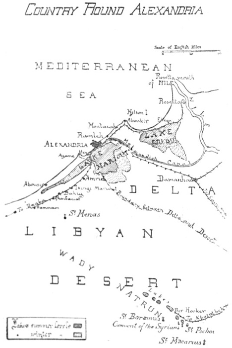
Country Round Alexandria
175At Sidi Gaber sta. is a view of Lake Hadra on the right.—Five stations on:—Victoria, close to the College and tram terminus.—The train passes over sand and through a palm oasis, which is carpeted with flowers in spring.
Mandarah Sta.—One of the houses in the village is painted outside in commemoration of the inmates pilgrimage to Mecca—pictures of things that he saw or would like to have seen, such as a railway train, a tiger, a siren, and a very large melon.
Montazah Sta.—Close to the station is the Summer Resort of the ex-Khedive Abbas II, now (1922) being restored and refurnished by King Fouad. Permission to enter should be obtained if possible, for the scenery is unique in Egypt and of the greatest beauty. The road leads by roses, oleanders and pepper trees. From it a road turns, right, up the hill to the Selamlik (men’s quarters), built by the Khedive in a style that was likely to please his Austrian mistress; on the terrace in front is a sun dial and some guns. From the terrace, View of the circular bay with its fantastic promontories and breakwaters; the coast to the right is visible as far as Aboukir, whose minaret peeps over a distant headland; to the left are the Montazah woods; beneath, down precipitous steps, a curved parade. Beautiful walks in every direction, and perfect bathing. On the promontory to the right is a kiosk, and at its point are some remains of buildings or baths—fragments of the ancient Taposiris Parva that once stood here; some of them form natural fishponds. The woods are Pines Maritimes, imported by the Khedive from Europe, and in the western section, beyond the Pigeon House, the trees have grown high. Various buildings are in the estate; in one corner are the foundations of an enormous mosque. During the recent war (1914-1919) 176Montazah became a Red Cross Hospital; thousands of convalescent soldiers passed through it and will never forget the beauty and the comfort that they found there.
Mamourah Sta.: The low ground to the right is on the site of the Aboukir Lake (p. 87), drained in the 19th cent. Here the Aboukir and Rosetta railways part.
ABOUKIR.
Route:—Aboukir Station is the terminus. Walk or take donkey. Turn sharply to the left to Canopus, 1 mile, then follow coast all the way round by Fort Kait Bey to Fort Ramleh; return to Aboukir Village.
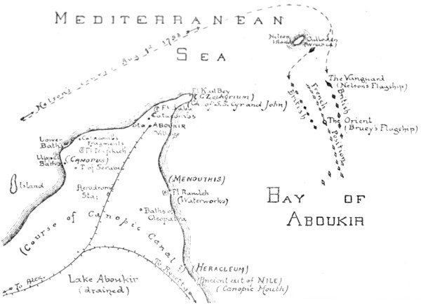
Aboukir and District
Aboukir, though intimately connected with Alexandria, has a history of its own. Three main periods.
(i). Ancient (see also p. 7).
Geologically, this is the end of the long limestone spur that projects from the Lybian desert (p. 5). The Nile had to round it to reach the sea, and it is to the Nile that its early fame is due. The river poured out just to the east, through the “Canopic” Mouth, which has now dried up, and there were settlements here centuries before Alexandria was founded. On the left bank of the Nile (south of the present Fort Ramleh) Herodotus (B.C. 450) saw a temple to Heracles, and was told that Paris and Helen had sought shelter here on their flight to Troy—shelter that was refused by the local authorities, who disapproved of their irregular union. There was a second settlement at Menouthis (Fort Ramleh itself), and a third and most famous at Canopus (present Fort Tewfikieh), from which the whole district took its name.
Canopus, according to Greek legend, was a pilot of Menelaus who was bitten here by a serpent as they returned from Troy, and, dying, became the tutelary God. The legend, like that of Paris and Helen, shows how interested were the Greeks in the district, but has no further importance. There is also a legend that Canopus was an Egyptian God whose body was an earthenware jar: this too may be discredited. With the foundation of Alexandria (B.C. 331) the district lost much of its trade, but became a great fashionable and religious resort. There was a canal from Alexandria, probably connecting with the Nile just where it entered the sea, and the Alexandrians glided along it in barges, singing and crowned with flowers. In connection 177with his new cult of Serapis (p. 18) Ptolemy Soter built a temple here (see below) whose fame spread over the world and whose rites made the Romans blush with shame or pale with envy; here originated the idea, still so widely held in the west, that Egypt is a land of licentiousness and mystery. The district decayed as soon as Christianity was established; it had not, like Alexandria, a solid basis for its existence in trade. But Paganism lingered here, and as late as the end of the 5th century twenty camel-loads of idols were found secreted in a house and were carried away to make a bonfire at Alexandria. Demons gave trouble even in later times.
(ii). Christian.
The Patriarch Cyril (p. 51) having destroyed the cults of Serapis and Isis in the district (A.D. 389) sent out the relics of St. Cyr to take their place. The relics were so intermingled with those of another martyr, St. John, that St. John had to be brought too, and a church to them both arose just to the south of the present Fort Kait Bey. The two Saints remained quiet for 200 years, but then began to disentangle themselves and work miracles, and recovered for the district some of its ancient popularity; indeed many of their cures are exactly parallel to those effected in the temple of Serapis. With the Arab invasion their church vanishes, but St. Cyr has given his name to modern Aboukir (“Father Cyr.”) In the 9th century the Canopic branch of the Nile dried up. The Turks built some forts here for coastal defence, but history does not recommence until the arrival of Nelson.
(iii). Modern.
In Napoleonic times Aboukir saw two great battles.
178(a). “Battle of the Nile.”
For the event that led to this engagement see p. 86. Brueys, Napoleon’s admiral, brought his fleet into the bay for safety, and anchored them in a long line, about two miles from the coast. He had 13 Men-of-War, 4 Frigates, 1182 canons, and 8000 men. To the north was “Nelson’s Island,” as it is now called, which he had fortified and upon which his line was supposed to rest. His flagship, the Orient, was midway in the line. He took up this position on July 7th, 1798.
On August 1st Nelson arrived in pursuit, with 14 Men-of-War, 1012 canons and 8068 men. The wind was N.W., a usual direction in summer. Half his fleet, including his flagship the Vanguard, attacked Brueys from the expected quarter, the east. The other half, led by the Goliath, executed the brilliant manœuvre that brought us victory. It gave Brueys a double surprise: in the first place it passed between the head of his line and “Nelson Island” where he thought there was no room; in the second place it took up a position to his west, between him and the shore, 179where he thought the water was too shallow. Thus he was caught between two fires—attacked by the whole British Fleet with the exception of the Culloden, which, sailing too near Nelson Island, stranded.
The engagement began at 6.00 p.m. At 7.00 Brueys was killed, at 9.30 the Orient caught fire and blew up shortly afterwards; the explosion was tremendous and terminated the first act of the battle; an interval of appalled silence ensued. Casabianca was sailing the Orient, and it was on her “burning deck” that the boy of Mrs. Hemans’ poem stood. The fighting recommenced, continuing through the night, and ending at midday on the 2nd with the complete victory of Nelson. The French fleet had been annihilated; only two Men-of-War and two Frigates escaped, and Napoleon had lost for ever his command of the Mediterranean. Nelson accordingly signalled the following message:—
Almighty God having blessed His Majesty’s arms with victory, the Admiral intends returning public thanksgiving for the same at two o’clock this day, and he recommends every ship doing the same as soon as convenient.
The French expected an attack on Alexandria, but Nelson had suffered too much himself to attempt this; having rested for a little, he dispersed his fleet, leaving only a few ships behind to watch the coast. In his despatches home he stated that the engagement had taken place not far from the (Rosetta) mouth of the Nile; hence the official “Battle of the Nile” instead of the more accurate “Naval Battle of Aboukir.”
(b). Land Battle of Aboukir.
Less important than its predecessor, but the strategy is interesting, and Napoleon himself was present. For the events that led up to it see p. 87; Turkey, at the instigation of England, had declared war on France, and in July 1799 the Turks occupied Aboukir Bay and landed 15,000 men. Their left rested on the present Fort Ramleh, their right on the present Fort Tewfikieh, their camp was in the narrow extremity of the peninsula, between the redoubt and the Fort at the very tip. They were supported on three sides by their fleet, which was stationed in the Mediterranean, in the Bay of Aboukir, and in the (vanished) Lake of Aboukir. From this stronghold they proposed to overrun Egypt.
On receiving the news, Napoleon hurried down from Cairo and arrived (July 25th) with only 10,000 men, mostly cavalry. Murat and Kléber accompanied him. He began by clearing the Turkish gun boats out of Lake Aboukir; then his force attacked Forts Ramleh and Tewfikieh, while his cavalry under Murat, advancing over the level ground between them, drove the flying defenders of each into the Mediterranean and the Bay respectively. 5,400 Turks were drowned. The tip of the peninsula 180remained and resisted vigorously, but Napoleon managed to mount some of his guns on the hard spit of sand that still extends along the shore of the Bay, and thus to cannonade the Turkish Camp, which was finally taken by storm.
Ruins of Canopus.
The ruins (see above) lie round Fort Tewfikieh which is seen to the left as the train runs into the station. They were once of interest, but have been almost entirely destroyed by the military authorities, who use the limestone blocks for road making, and allow treasure hunting to go on. The remains are not easy to find, as the area is pitted with excavations. Consult map.
(a) About 50 yds. from the gateway of the fort, in a hollow to the left of the road, are two huge Fragments of a granite temple. Here were found the busts of Rameses II in the Museum (Room 7) and the colossi of the same King and his daughter (Museum, Court). Date of statues:—B.C. 1300.
(b) Further to the left, round the Fort, is the site of the Temple of Serapis, the most famous building on the peninsula, and celebrated throughout the antique world. It was dedicated by Ptolemy III Euergetes (p. 15) and his wife Berenice. A few years later (B.C. 238) their baby daughter died, and the priests met here in conclave to make her a goddess, and incidentally to endorse some reforms in the Calendar that the King, who had a scientific mind, was pressing. The pronouncement has been preserved in the “Decree of Canopus,” now one of the chief documents for Ptolemaic history. As for miracles, the temple even outstripped the original Temple of Serapis at Alexandria: invalids who slept here even by proxy discovered next day that they were well. It was also the abode of magic and licentiousness according to its enemies, and of philosophy according to its friends. Christianity attacked it. Just before its destruction (A.D. 289) Antoninus, an able pagan reactionary, settled here, and tried to revive the cult. “Often he told his disciples that after his time there would be no temple, 181and that the great and venerable sanctuary would remain only as an unmeaning mass of ruins, forgotten by all.” (Eunapius, life of Edesius). Antoninus was right.
In ancient time the Temple probably stood on the highest ground, but with the general rising of level the site is now in a deep depression and must be hunted for patiently. An oblong space has been cleared and some columns and capitals from the excavations have been ranged round it, but it is impossible to reconstruct the original plan, and much has yet to be unearthed. Indeed it is not quite certain that this is the right temple; an inscription has been discovered dedicating it not to Serapis but to Osiris—with whom however Serapis was often identified. The columns are of granite or of stucco-coated limestone. Beneath the broken tin shelter was once a pretty mosaic. The finest object is a stupendous fluted column of red granite that lies in a pit close by; no use for it has yet occurred to the military authorities. To the south and east of the Temple were the houses of the priests, showing fine cemented passages; these have been destroyed.
The canal by which revellers and worshippers approached this shrine ran to the south, through the low land by the railway; its course is uncertain; its exit was either into the (vanished) Nile, or into Aboukir Bay.
(c) The Upper Baths. These lie about 100 yds. nearer the sea, on the slope just above the corner of the great bay that stretches to Montazah (p. 175). When excavated a few years ago they were almost perfect. The swimming bath—lined with the hard pink cement that indicates Ptolemaic or Roman work—had at the top a double step for the bathers. All round its sides were inserted large earthenware pots, their mouths level with the surface. Of this unique building a small fragment now survives. The brick central cistern and the hot baths can also still be traced.
(d). The Lower Baths and Broken Colossus.—Continuing to round Fort Tewfikieh we reach the coast and follow it N.E. Awash with the sea are the foundations 182of some large baths, showing the entrance channels which were probably closed with sluices, also some grooves of unknown use. On the shore above are the hot baths of the same establishment, retaining traces of pink cement. In the surf to the left lie blocks of granite: closely inspected, they resolve into fragments of a Colossus (Rameses II?) and a sphinx.
(e). Catacombs.—Fifty yards on, at a point about half-way between the coast and the fort are a couple of catacombs, lying each of them in a hollow. One has a subterranean room, the other a sarcophagus slide. Traces of tombs and tunnels all over the area and along the low cliff by the shore.
This completes our survey of Canopus, once so enchanting a spot. Of its ancient delights only the air and the sea remain.
Continue to follow the coast. Perfect bathing. To the right, half-way between the coast and the railway sta. in some rising ground, are catacombs that have been filled in. Then comes the end of the promontory, which is fine. There are two forts:—Fort Saba, closing the neck, where the French resisted when the Turks landed in 1799 (see above); and Fort Kait Bey, on the extremity, founded in the 15th cent. by the Sultan of that name as part of his defence scheme against the Turks (cf. Fort Kait Bey at Alexandria, p. 81). The views are good, with the Mediterranean on one side and the tranquil semi-circle of Aboukir Bay on the other, and from here or from Fort Ramleh the scene of the “Battle of the Nile” can be surveyed, and Nelson’s great manoeuvre appreciated; “Nelson’s Island” from which the French line depended and where the Culloden was wrecked lies straight ahead. (see above.) The promontory was anciently called Zephyrium, because it caught the cool zephyr winds; here stood a little temple to Aphrodite and when the great queen Arsinoe, died in B.C. 270, one of the court admirals had the happy idea of associating her with the elder goddess so that mariners might render 183thanks to both. The shrine then became fashionable and Queen Berenice hung up her hair here in 244 as a thank-offering for her husband’s safe return; in the following year the hair was snatched up to heaven, where it may still be observed on any fine night as the constellation of Coma Berenice. The temple was less fortunate, and all that remains of it is the base of a column, down among the rocks.—In Christian times the Church of St. Cyr and St. John (see above) stood here, on the side of Aboukir Bay.
Aboukir Bay.—The shore is airless and there are palm trees, the waters shallow. From a boat one can look down on the mud in which the Orient, Brueys’ flagship, has disappeared with all her treasure; attempts have been made to locate her, but in vain. Good sailing. Turtle fishing. On the projecting spit to which Napoleon dragged his guns (see above) is the landing enclosure for the fishing boats; many of the fishermen are Sicilians; they have lived at Aboukir for generations and form a community by themselves. Here (site uncertain) once stood Menouthis.
Fort Ramleh.—Topped by the waterworks. Magnificent view. The flat ground to the south marks the Canopic Mouth of the Nile, through which Herodotus entered Egypt; here Heracleum stood (see above).
About quarter mile S.W. of Fort Ramleh, and close to a small modern pumping tower, are the so-called Baths of Cleopatra. She had nothing to do with them, but they are worth seeing. The western outer wall, of limestone blocks, is well preserved. Steps lead up through it. Within are pavements of pebble mosaic, fragments of stucco, a stone with a drain groove, &c. In a chamber to the left, is an oblong bath nearly six feet deep; steps lead down to it and in the centre of its pebbled floor is a little depression; in the edge of the brim and on the wall opposite are niches, as if to support beams, and provision for the entrance and exit of the water can also be seen. Further on, past a small stucco cistern, is an entrance to a small room which contains an oblong bath 184to lie down in, quite modern and suburban in appearance; close to it, under a niche, is a footbath—the bather sat on a seat which has disappeared but whose supports can be seen.—These baths are all in the western part of the enclosure; the rest contains other and larger chambers but is in worse preservation. It is much to be wished that these baths, which have been recently excavated, could be protected properly; otherwise they will share the fate of the other antiquities within the military zone.
Aboukir Village, to which we return through palm trees, contains nothing of note.
On leaving Mamourah Junction (p. 176) the railway to Rosetta bears to the right, and crosses the salt marshy ground over which the Canopic branch of the Nile once flowed to the sea. Rural Egypt can be seen at last. Beyond El Tarh station the train crosses a bit of Lake Edku; view of the village to the left.
Edku (no hotel or café) stands on a high mound between the lake and the Mediterranean. The houses in its steep streets are of red brick strengthened with courses of palm and other woods; they anticipate the more complicated architecture of Rosetta; there are some carved doors, Italianate in style. Mosques, unimportant. On the top of the ridge are some eight sailed windmills; they grind corn. Fine date palms grow on the sand dunes towards the sea, for there is fresh water just beneath the surface. There is an interesting local weaving industry, chiefly of silk, imported in its rough state from China. The work rooms are generally on the upper floors of the houses, and reached by an outside staircase. Quiet pleasant places; on the walls of some are Cufic inscriptions, inlaid in brick. The weavers sit to their looms in small oval pits; they have the hands of craftsmen and produce on their simple wooden machinery fabrics that are both durable and beautiful.
Fish are caught in Lake Edku. Some of the fishermen wade far into shallow waters; there is also a fleet 185of boats which moor to the long wooden jetty by the station. Occasional flamingoes.
The railway continues between lake and sea, finally bending northward and curving round great groves of palm trees, behind which lie the town of Rosetta and the river Nile.
ROSETTA.
Rosetta and Alexandria are rivals; when one rises the other declines. Rosetta, situated on the Nile, would have dominated but for an overwhelming drawback: she has, and can have, no sea-harbour, because the coast in this part of Egypt is mere delta; the limestone ridges that created the two harbours of Alexandria do not continue eastward of Aboukir. Alexandria required organising by human science, but once organised she was irresistible. It is only in an unscientific age that Rosetta has been important. Let us briefly examine the birth and death, rebirth and decay, of civilisation here.
(i). In Pharaonic times the town and river-port of Bolbitiné were built hereabouts—probably a little up stream, beyond the present mosque of Abou Mandour. Nothing is known of the history of Bolbitiné. When Alexandria was founded (B.C. 331) traffic deserted the “Bolbitiné” mouth of the Nile for the “Canopic” and for the Alexandrian harbours, and the town decayed consequently. Its chief memorial is the so-called “Rosetta Stone,” a basalt inscription now in the British Museum. The inscription enumerates the merits of King Ptolemy V Epiphanes (B.C. 196; see genealogical tree p. 12). It is a dull document, a copy of the original decree which was set up at Memphis and reproduced broadcast over the country. But it is important because it is written in three scripts—Hieroglyphic, Demotic and Greek—and thus led to the deciphering of the ancient Egyptian language. The antique columns &c. that may be seen in Rosetta to-day also probably came from Bolbitiné. But it was never important, and the sands have now covered it.
(ii). Rosetta itself was founded in A.D. 870 by El Motaouakel, one of the Abbaside Caliphs of Egypt. The date is most significant. By 870 the Canopic mouth of the Nile had dried up, and isolated Alexandria from the Egyptian water system. Shipping passed back to the Bolbitiné mouth, and frequented it again for nearly a thousand years. “El Raschid” as the Arabs named 186the new settlement, became the western port of Egypt, Damietta being the eastern. It was important in the Crusades; St. Louis of France (1049) knew it as “Rexi.” In the 17th and 18th centuries it was practically rebuilt in its present form; the mosques, dwelling houses, cisterns, the great warehouses for grain that line the river bank, all date from this period, it evolved an architectural style, suitable to the locality. The chief material is brick, made from the Nile mud, and coloured red or black, there was no limestone to hand, such as supplied Alexandria: with the bricks are introduced courses of palm wood, antique columns &c. and a certain amount of mashrabiyeh work and faience. The style is picturesque rather than noble and may be compared with the brick style of the North German Hansa towns. Examples of it are to be found throughout the Delta and even in Alexandria herself (p. 125), but Rosetta is its head quarters. In architecture, as in other matters, the town kept in touch with Cairo; an Oriental town, scarcely westernised even to-day. So long as Alexandria lay dormant, it flourished; at the beginning of the 19th century its population was 35,000, that of Alexandria 5,000.
In 1798 Napoleon’s troops took Rosetta, in 1801 the British and Turks retook it, in 1807 the reconnoitring expedition of General Frazer (p. 89) was here repulsed. These events, unimportant in themselves, were the prelude to an irreparable disaster: the revival of Alexandria, on scientific lines, by Mohammed Ali. As soon as he developed the harbours there and restored the connection with the Nile water systems by cutting the Mahmoudieh Canal, (p. 91), Rosetta began to decay exactly as Bolbitiné had decayed two thousand years before. The population now is 14,000 as against Alexandria’s 400,000, and it has become wizen and puny through inbreeding. The warehouses and mosques are falling down, the costly private dwellings of the merchants have been gutted, and the sand, advancing from the south and from the west, invades a little farther every year through the palm groves and into the streets. One can wander aimlessly for hours (it is best thus to wander) and can see nothing that is modern, nor anything more exciting than the arrival of the fishing fleet with sardines. It is the East at last, but the East outwitted by science, and in the last stages of exhaustion.
The main street of Rosetta starts from the Railway Station and runs due south, parallel to the river, so it is easy to find one’s way. In it is the only hotel, kept by a Greek; those who are not fastidious can sleep here: the rest must manage to see the sights between trains. The hotel has a pleasant garden, overlooked by the minaret of a mosque.
187In the main street, to the right;—Mosque of Ali-el-Mehalli, built 1721, but containing the tomb of the Saint, who died in the 16th century. A large but uninteresting building, with an entrance porch in the “Delta” style—bricks arranged in patterns, pendentives, &c.
Further down, to the left, by the covered bazaars: Entrance with old doors to a large ruined building, probably once an “okel” or courtyard for travellers and their animals; one can walk through it and come out the other side through a fine portal, in the direction of the river. All this part of the town is most picturesque. The houses are four or five stories high, and have antique columns fantastically disposed among their brickwork. The best and oldest example of this domestic architecture is the House of Ali-el-Fatairi, in the Haret el-Ghazl, with inscriptions above its lintels that date it 1620: its external staircase leads to two doors, those of the men’s and women’s apartments respectively. Other fine houses are those of:—Cheikh Hassan el Khabbaz in Rue Dahliz el Molk; Osman Agha, at some cross roads,—carved wood inside, date 1808; Ahmed Agha in the Chareh el Ghabachi to the west of the town, invaded by sand.
At the end of the main street is the most important building in the town, the Mosque of Zagloul. It really consists of two mosques: the western was founded about 1600 by Zagloul, the Mamaluke or body-servant of Said Hassan; the other and more ruinous section is the mosque of El Diouai. There is a courtyard with fountain in centre. The entire mass measures about 80 by 100 yds. All is brick except the two stone minarets; the ruined one was “cut with scissors” according to local opinion, but according to archaeology fell in the early 19th cent. The sanctuary of the Mosque of Zagloul proper is a stupendous hall; over 300 columns, many of them antique, are arranged in six parallel rows, there are four praying niches, three of them elaborately decorated, there is the tomb of the ex-body-servant himself, now worshipped as a saint and wooed by votive offerings of 188boats, and, in the tomb, his former master, the Said Hassan, lies with him, and shares his honours. The sanctuary is ruinous and carelessly built, but its perspective effects, especially from the south wall, near the tomb, are very fine and rival those of the Mosque of El Azhar at Cairo. Light enters through openings in the roof.
East of the Mosque of Zagloul and close to the river is the Mosque of Mohammed el Abbas, date 1809, of superior construction but on the same style; it has, unlike the other mosques of Rosetta, a fine dome, covering the tomb of the saint.
Other Mosques:—Toumaksis Mosque, built by Saleh Agha Toumaksis in 1694; it is reached up steps; fine iron work round the key holes; there is a good pulpit inside, also tiles, and the prayer niche retains its original geometrical decoration of hexagons and “Solomon’s seals.”—Mosque of Cheikh Toka, which stands in an angle of the Chareh Souk el Samak el Kadim; portal in “Delta” style with rosace over its arches; inside, pulpit dated 1727.
About a mile to the south of the town, best reached by boat, is the Mosque of Abou Mandour, a showy modern building, well placed on the bend of the river bank, and backed by huge sand hills that threaten to bury it, as they have buried Bolbitiné.
North of the town, and half-way between it and the sea, is the site of Fort St. Julien, which Napoleon’s soldiers built, and where they discovered the Rosetta Stone. The Fort has disappeared; there is a sketch of it in the Alexandria Museum (Vestibule).
Sailing on the Nile: delightful.
189
Section VIII.
THE LIBYAN DESERT.
Routes:—By the Mariout Railway to Bahig for Abousir and for St. Menas; each expedition takes a day.
By Railway via Tel-el-Baroud and Khatatbeh to the Wady Natrun; 2 or 3 days.
190Alexandria, though so cosmopolitan, lies on the verge of civilisation. Westward begins an enormous desert of limestone that stretches into the heart of Africa. The very existence of this desert is forgotten by most of the dwellers in the city, but it has played a great part in her history, especially in Christian times, and no one who would understand her career can ignore it.
The Mariout Railway was originally the property of the ex-Khedive. The line starts from the central station and diverges from the main line at Hadra. Having passed Nouzha station (Section IV) it crosses the Mahmoudieh Canal (p. 91) then bends westward along the edge of Lake Mariout. Just before Gabbari Garden station is a fishing village built on a tiny creek and quite Japanese in appearance. It is worth going down here when there has been a catch: the lake fish are uncanny monsters. The neighbourhood is very fertile—palms bananas and vegetable gardens. But it does not make pleasant walking owing to the smells.
Mex Station. (Section VI). The train crosses the western or Mellaha arm of Mariout. Right, are the salt pans that turn dull purple and red in the summer beyond them the white spur of limestone that divides lake from sea.
Abd el Kader Station. Now we approach the Libyan desert. The scenery and the people change. From the hill to the right, by the tomb, is a fine view, and wonderful colour effects in the evening.
Amrieh Station. This large village was formerly head of the Eastern district of the Western Desert Province, but the Administration is transferring to Burg el Arab. Bedouins come to the train, bigger and wirier than the Egyptians, and more graceful; they wear rough white robes and soft dark red tarbooshes.—There 191is a fine walk from Amrieh to Mex—the best day’s tramp near Alexandria. The path leads north from the station, by the communal gardens, then makes for a ridge where limestone is quarried. View from the top over the western arm of Mariout. Take the causeway that crosses the lake and on the further bank turn to the right, finally crossing the coastal ridge to Dekhela (Section VI) and so to Mex by the sea shore.
Ikingi Mariout Station. (Ikingi is Turkish for “second.”)—A good centre for the wild flowers of February and March. Go northward towards the lake, and keep to the lower ground; the local flora is one of the finest in the world.
Bahig Station.—Centre for two fine expeditions—Abousir on the coast, and St. Menas inland.
ABOUSIR.
The ruins of Abousir lie 5½ miles N.W. from Bahig station. They can be found without a guide. (see map). There is a good road as far as Bahig village (¾ mile). Just above the village is a big quarry, worked in ancient times and very picturesque. A path crosses the ridge rather to the left of this quarry, after which the ruins are in sight all the way. The end of Mariout has to be crossed, so the expedition should not be made in winter on account of the mud. The last half hour of the journey is magnificent. The Temple and the Tower stand out on the height, which is golden with marigolds in spring time; and near the top of the ascent the sea appears through a gap, deep blue, and beating against a beach of snowy sand. The flowers can be amazing, colouring the earth in every direction. The ruins are supposed by the Bedouins to be the palace of Abou Zeit; they really mark the Ptolemaic city of Taposiris, whose name is preserved in the modern Abousir.
Taposiris must have been built soon after Alexandria (about 300 B.C.), and it is instructive to compare the two towns. They stand on the same spur—Taposiris at its base, where it has 192emerged from the mass of the desert. The lake is to their south, the sea to their north, so each commanded two harbours, to the advantage of their trade. Each has a lighthouse, each worshipped Osiris. Little is known of the history of Taposiris—called the “Great” to distinguish it from “Little” Taposiris at Montazah (p. 175). Its immediate trade was with the lake, its sea-harbour being ½ mile below, at the vanished port of Plinthinus. The Arabs turned the Temple of Osiris into a fortress, and in modern times coast guards have been installed here.
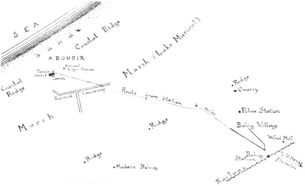
Abousir and District
The Chief remains are:—
(i). Temple of Osiris. The eastern, and main, entrance adjoins the coast-guard station. At first sight it looks no more than a hole in a ruined wall, but it can easily be reconstructed. Each side of the entrance were Gate-towers (Pylons) like those of Edfu or Kom Ombo in Upper Egypt. Their bases project from the main wall, and up the face of each are two grooves for flag staffs, from whose tops crimson streamers floated. Staircases, reached from the inside, ascend each tower, and there are also two square rooms in the base of each.
The enclosure—about 100 yards square—is in a terrible mess. The actual temple has disappeared. There must have been a colonnaded court with an altar in the middle, and beyond it the temple facade: on north and south of temple would have been other courts. The arrangements were Egyptian, but some of the workman were Greek; mason marks with Greek letters (e.g. Alpha Kappa Rho) have been found on the stone in the boundary wall.
The north boundary wall of the enclosure is very fine; it projects over the slope of the hill and rests on substructures: in it is a gate for the descent to the sea. Note the projections in the masonry. In the north west corner are some architectural fragments, piled up by the Arabs. 194(ii). Lighthouse. The ruined tower on the hill to the east of the temple was once mistaken for a tomb, since it stands in the ancient cemetery. It is really the Ptolemaic lighthouse of Taposiris, first of a chain that stretched from the Pharos at Alexandria all down the North African coast to Cyrene. It has, like the Pharos, three stages: a square basement, an octagonal central stage and a cylindrical top. On the north, where the outer wall of the octagon has fallen, one can see the marks of the staircase by which the wood was carried to the top—a simpler version of the double spiral that ascended the huge Alexandrian building. There can be no doubt that the Taposiris lighthouse was modelled on its gigantic contemporary—scale about ⅒th—and it is thus of great importance to archaeologists and historians. (see throughout p. 133).
There are tombs close to the lighthouse, and tombs and houses all along the slope to the south of the temple.
(iii). Causeway. South of the town, in the bed of the lake, are traces of the embankment that connected with the desert. It was doubtless pierced with arches like the Heptastadion at Alexandria, to allow boats to go through.
The other point of interest in the district is Burg el Arab (Modern Bahig). It lies some miles west of Bahig village (see above) but is easily located by the tower of the new carpet factory. Here is to be the capital of the Eastern District of the Western Desert Province Frontier Districts Administration; it is being planned and executed with great taste, thanks mainly to the genius of the Officer Commanding, W. E. Jennings Bramly, M.C. The factory consists of a great cloister and of two halls, one each side of the big tower. Fragments of antique sculpture and architecture have been cleverly introduced. The carpets are woven from camels’ and goats’ hair by Bedouin and Senussi women—the industry was started at Amrieh, during the late war. Specimens can be had in the Alexandrian shops. Further to the west other buildings are rising, including a small walled town. It is all most interesting, and one of the few pieces of modern creative work to be seen in these parts.
195
ST. MENAS.
Seven and a half miles south of Bahig Station, in the loneliness of the desert, lie the ruins of a great Christian city. They can be visited between trains on a good horse, but it is better to camp out. The track passes over gently undulating expanses of limestone. The scenery grows less interesting, the flora scarcer, as the coast is left behind. At last the monotony is broken by the square hut where the excavators used to live. The ancient name of the place is preserved in the modern—Abumna.
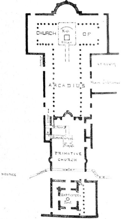
St Menas Plan I. The Sanctuary Group Subterranean work thus .........
Menas, a young Egyptian officer, was martyred during his service in Asia Minor because he would not abandon Christ (A.D. 296). When the army moved back into Egypt his friends brought his ashes with them, and at the entrance of the Lybian Desert a miracle took place: the camel that was carrying the burden refused to go further. The saint was buried and forgotten. But a shepherd observed that a sick lamb that crossed the spot became well. He tried successfully with another lamb. Then a sick princess was healed. The remains were exhumed, and a church built over the grave.
This church can still be traced. It is the Basilica of the Crypt (Plan I p. 196) date 350, to which, at the end of the century, an immense extension was added by the Emperor Arcadius. What caused so rapid a growth? Water. There were springs in the limestone that have since dried up, and that must have had curative powers. Baths were built, some of them opening out of a church (Plan II). Little flasks, stamped with the Saint’s image, were filled from the sacred source by his tomb. The environs were irrigated, houses, walls, cemeteries built, until in the pure air a sacred city sprang up, where religion was combined with hygiene. Nor did the saint only protect invalids. He was also the patron of the caravans that passed by him from Alexandria to the Wady Natrun, the Siwan Oasis, and Tripoli, and so he is always seen between two camels, who crouch in adoration because he guides them aright. By the 6th century he had become god of the Lybian Desert, then less deserted than now, and his fame, like that of his predecessor Serapis, had travelled all round the Mediterranean, and procured him worshippers as far as Rome and France.
196Islam checked the cult. But as late as the year 1,000, an Arab traveller saw the great double basilica still standing. Lights burned in the shrine night and day, and there was still left a little trickle of “the beautiful water of St. Menas that drives away pain.”
The site, entirely forgotten, was discovered in 1905. It has been carefully excavated. Little more than the ground plans of the buildings remain, but they are most interesting, and the marble decorations delightful.
197
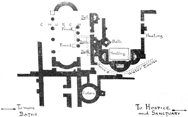
St Menas – Plan II. The Sacred Baths
198The Sanctuary Group. This lies a little to the south of the excavators’ huts. Combined length, nearly 400 ft. In the centre is the original church covering the tomb. To its east is the impressive addition of Arcadius; to its west a baptistery. On its north side a monastery. The best view of the group is from a mound outside the baptistery. The general arrangement is quite clear. (Plan I, p. 196). Taken in detail:—
(i). Church of Arcadius.—Length nearly 200 feet. A cruciform basilica with a nave and two aisles, and aisled transepts. Over the intersection was a dome, beneath which, now much ruined by its fall, is the High Altar. Behind the altar are curved steps that supported the ecclesiastical throne. Both altar and throne are in a square enclosure where the priests and singers stood; a narrow alley connects it with the nave. The eastern apse has been used for burials.
The Nave is paved with white marble from the Greek archipelago. Green and purple marbles (verde antico and porphyry) were also used. From its south aisle, three doors open into a fine atrium. This was the principal approach to the church. The north aisle opens—at its east end—on to a staircase that ascended to the roof of the church; the other doors to the monks’ apartments and hospice (see below). The west end of the nave is irregular, because the apse of the primitive church impinges.
(ii). Primitive Church. A small, three-aisled basilica, not well preserved, but with interesting crypt. The descent to this is by a marble staircase that starts in the Arcadian church, passes by a portico with a vaulted roof of brick, and then, after a little, turns to the south into an oblong subterranean chamber. Here, amid rich decorations, the ashes of the young saint once lay, is a tomb that was probably visible from the church above. A 199bas-relief of him was fixed to the south wall; the place for the marble slab can still be seen there. The ugly bas-relief in the Alexandria Museum (Room I) is a copy. Attached to the crypt is a chapel once vaulted with gold mosaic; the well in it was made by treasure-hunters.
On the west of the church runs the sacred water course from which the sanctuary derived its fame. It is a subterranean cistern, over 80 yards long; a shaft was sunk into it from the nave. Passing, as it did, so near to the saint’s remains, it had special sanctity. The water was used to fill flasks, and also in the adjacent Baptistery.
(iii). The Baptistery is square without and octagonal within. In its centre, down steps, is the chief font, which had an over-flow canal; we do not know how it was filled. The floor was richly inlaid with serpentine, porphyry and other marbles. There was a dome. On its south side is an atrium. On its western exterior, niches for statues.
A Baptistery of this type—separate from the rest of the church—is common enough in the West. But in the East it is unique. Only at St. Menas, where water was so prominent in the worship, does it occur.
Immediately to the north of the Sanctuary Group are the Monastery Buildings and Hospice, a confused labyrinth. Best is a hall paved with marble and one supported by eight columns. It lies 40 yards due north from the gate of the Primitive Church. These buildings, together with the Sanctuary Group that they served, cover an area of over 40,000 square yards.
The Sacred Baths (Plan II). About 80 yards from the Monastery Buildings. Best located by the fine circular cistern of well-cut limestone blocks. The main building has a heating apparatus and three baths. Also a small but finely finished church; basilica type; apses at each end; three aisles. Two baths open straight out of its 200south aisles, and in its nave are two marble fountains that were probably filled from the source in the central sanctuary (see above). Throughout the arrangements are significant. The line between the hygienic and the miraculous is nowhere clearly drawn; heating apparatus and church have each to play their parts. Date of the group, probably 5th century. Another group lies beyond.
Northern Cemetery.—This, the most important in the city, is some way from the groups above described. Indeed the visitor from Bahig leaves it to his left on his way to the hut. There is a good view of it from a mound. The main object is a church (150 ft. long), with three aisles, a square apse and numerous mortuary chapels where the more prominent invalids were buried. Others lie outside. Late date—7th-9th cent.
This by no means catalogues the ruins of St. Menas. There is a Southern Cemetery, private houses, wine presses, a kiln where the terra cotta flasks were made. All the desert around shows remains of the curious cult, which in some ways anticipated the methods of Lourdes.
Half a day over the desert southward brings a rider to the Wady Natrun.
THE WADY NATRUN.
The Wady is best visited by arrangement with the Egyptian Salt and Soda Company, who have the concession for developing that section of it where the Lakes and the Monasteries lie. The Company’s private railway starts at Khatatbeh, on the branch line between Cairo and Tel-el-Baroud (see Map. p. 174). The train curves up the desert to Bir Victoria, where it waters beneath a solitary tree. Then it leaves civilisation, and for three hours nothing is seen except an occasional gazelle. At the end of that time the ground falls away to the left, and the monastery of St. Macarius appears far off. Then is seen the chain of the lakes, and across 201them, often in mirage, the monasteries of St. Pschoi and The Syrians. The train descends to the terminus of Bir Hooker, close to the Company’s factory and rest house.
The Wady Natrun (i.e. Natron, Soda) is a curious valley that begins near Cairo, and slopes north-westward into the heart of the Lybian Desert. It may have once been an outlet of the Nile, though it is barred now from the sea by coastal hills. Its upper and lower reaches are both barren, but in the central section—that which the railway taps—water survives in the form of a chain of mineral lakes.
The deposits were worked from antiquity, but with the rise of monasticism the Wady took a new importance, owing to its discomfort. As early as A.D 150 St. Fronto retreated here from Alexandria. St. Ammon followed in 270; St. Macarius or Mercury a hundred years later. The more moderate ascetics extracted soda with the assistance of laymen; the extremists sought a waterless stretch called Scetis—probably the southern portion of the valley where the monastery to St. Macarius still stands. There were soon 5,000 monks. It is natural that so remote a community should lose touch with the theological niceties of the capital, and in 399 the Patriarch Theophilus was obliged to rebuke the monks for minimising the divine element in the Second Person. Their reply was startling. They crossed the desert, stormed Alexandria, and made the Patriarch apologise. A few years later he led an army into the Wady to punish them, but by now, oddly enough, they had veered to the opposite error; they minimised the human element. The truth is they represented native Egypt, the Patriarch the Hellenising coast. (see p. 51). The quarrel was racial rather than theological, and when in the 6th century it came to a head, the Wady became the natural stronghold of the national or Monophysite party who, under the name of Copts, worship there to this day.
With the 19th century came a new colony—the industrial. It is the factory chimney of the Salt and Soda Company that now dominates the scene. The lakes are dredged for their deposits. The chief product is caustic soda which is poured red hot into metal drums, and exported all over the east. Ordinary soda (natron) is also produced. The factory is interesting. It, and the surrounding settlement, are due in their present form to Mr. A. H. Hooker, after whom the settlement is named.
More than eighty different species of birds have been identified in the marshes surrounding Bir Hooker.
The Mineral Lakes.
These lie between the factory and the monasteries. Some of them are squalid, others are indescribably beautiful, especially in summer. The deposits form at the bottom. As they reach the top, the lake seems to be covered with white and crimson ice, in the midst of which are pools of blue and green water, and trickling streams of claret, and tracts that blush like a rose. When the scene is in mirage, its strangeness passes belief. A bird looks as big as a man, and the lump of salt it perches on shows like a boat of snow. The finest of these lakes is just to the left of Bir Hooker.
202
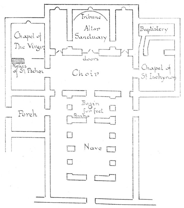
The Natrun Monasteries Plan I. Church Of St. Pschoi
203
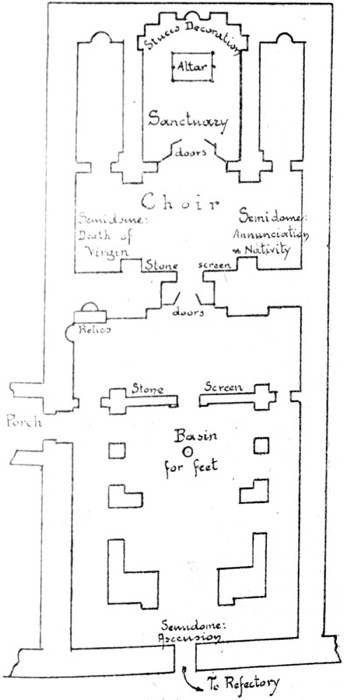
The Natrun Monasteries—Plan II Convent of the Syrians—Church of the Virgin.
204The Monasteries.
Four of these survive, and there are the ruins of many others. They are all of the same type, and to avoid repetitions it may be thus summarised:
Exterior:—an enclosure of stone laid in the middle of the desert, covering about an acre. Palm trees and buildings show over its walls. The walls are blank except for one high arch, which indicates the position of a little door, the only entrance. The black-robed monks, when the bell has been rung, look down from the parapet, then unbar the door, and take the traveller to the Guest House for coffee and lemonade. They are dirty and ignorant, but most courteous and hospitable. All payment is refused.
In the enclosure:—two or three churches, normally consisting of nave, choir, and sanctuary (kaikal). Refectory. Sleeping cells for the monks. Mill for grinding corn. Oven, where is baked the hard brown bread, and also the “isbodikon” (somatikon, sacrament), a cake of fine flour beautifully stamped with a cross and used for the Eucharist. Olive press. Granary. Garden of palm trees, bananas, capsicums, etc. Keep (kasr) for final retreat when attacked; reached only by a drawbridge from the parapet of the wall; contains library, dungeons, chapels; usually dedicated to St. Michael.
Date: general appearance and arrangement are of the 6th century. Most of the details are later.
205Extract from the Thanksgiving offered at the arrival of a distinguished visitor:—
He who visits these mansions with firm faith, fervent desire, true repentance and good works, shall have all his sins forgiven. Then, O my reverend fathers and my beloved brethren, come that we may pray for these our dear and honourable brethren, who are come upon this visit and have reached these habitations, let us pray that Jesus Christ, who was with his servants in every time and every place, may now be with them, and may deliver them from all sins and iniquities. May he grant them the best of gifts and full reward, recompensing them for all that they have endured through toil and peril and the weariness of the journey as they travelled hither; giving them abundance of blessing; bring them back to their homes in safety; and after long life transport them to the brightness of Paradise and the life of bliss, through the intercession of Our Lady the Virgin, and of all our holy fathers. Amen.[7]
The Four Monasteries.
(A). Convent of St. Pschoi (Deir Abou Bishoi). About an hour’s ride from Bir Hooker. Dedicated to St. Pschoi or Besa. “B” is the Coptic article, so the saint’s name is ultimately “Isa” i.e. Isaiah. Little is known about him.
The convent enclosure contains:
(i). The Church of St. Pschoi (Plan I, p. 202). 6th-11th cents. with later additions. A spacious entrance porch leads to the dark but impressive interior. There are three divisions: Nave, Choir and Sanctuary.
The Nave has an arched vault; massive piers with pointed arches divide it from its aisles. In it is an Ambon (lectern for reading the Gospel), and a small marble basin level with the floor, where the priest washes the feet of the people on Maundy Thursday in commemoration of the action of Christ. Many of the Nave arches have been blocked up to strengthen the building. High and narrow folding doors—recalling a Japanese screen—close the lofty arch that leads from the Nave into the Choir; they are set with fine carved panels, enclosed in ivory borders. Other doors lead from the aisles.
206The Choir too has vaulting, but it is at right angles to that of the Nave. At each side of the Choir are chapels, probably of later date. Left—Chapel of the Virgin, with a chest containing the relics of St. Pschoi, whom the monks state remains intact. Right—Chapel of St. Ischyrion; off it is the Baptistery. The entrance into the Sanctuary is through ancient carved doors; over them is a triumphant arch.
The Sanctuary has, behind the altar, a fine tribune of six steps—three straight and three curved. In the centre was the throne of the Abbot. It has gone, and the marble decorations of the steps are ruined. Above the throne is a marble mosaic. In the centre of the eastern dome is a Cross.
(ii). The Refectory.—This solemn room contains the immense stone table, narrow and low, at which the monks break their yearly fast. They do not eat here usually, and use the table as a drying place for onions, bread, etc., while cakes of salt are stacked against the wall. At the head of the table is the Abbot’s seat. The place is rough and indescribably untidy. But one could scarcely find a more striking relic of primitive Christianity.
(B). Convent of the Syrians (Deir es Suriani).—Close to the Convent of St. Pschoi. Founded by monks from Syria. Dedicated to the Virgin. Here Robert Curzon (1833) discovered in the oil cellar priceless Syrian, Coptic, and Abyssinian MSS., now in the British Museum. He describes his find in “Monasteries of the Levant”: it was facilitated by plying the Abbot with liqueurs. More were brought away by Archdeacon Tattam, and nothing valuable remains now.
The enclosure contains:—
(i). Church of the Virgin (Plan II, p. 203)—A fine building 40 ft. by 90, probably the model for the church in St. Pschoi—i.e. originating in the 6th century.
The Nave has piers with high pointed arches, and lofty vaulting, slightly pointed. In the middle, the basin for the Maundy feet washing, a marble slab with a circular 207depression. In the western semi-dome, fine fresco of the Ascension. Precious folding doors between nave and choir, inlaid with ivory panels of Christ in the nimbus of the Cross, the Virgin, St. Peter and St. Mark; round their posts and lintels a Syriac inscription, dating them back to the 7th century.
The Choir—North semi-dome; fresco of the Death of the Virgin. South semi-dome; fresco of the Annunciation and Nativity. Admirable work. More ancient doors between Choir and Sanctuary; ivory panel representing Dioscurus (Patriarch of Alexandria 450 and founder of Monophysism see p. 51), Mark, Emmanuel, the Virgin, Ignatius, and Severus (512). Syriac inscriptions of rather later type—8th century.
Sanctuary. Skilful and effective plaster frieze with a border below and panels of conventional trees and vines above. Above the eastern niche a panel of crosses. This unique decoration should be studied closely.
(ii). Smaller Church of the Virgin. Over its entrance to the south-west a marble cross in low relief. Inside, another cross in black marble. Probably dedication crosses. Pulpit in the choir.
(iii). Tamarind tree under the enclosing wall. St. Ephraim the Syrian (date 373) inadvertently, so they say, laid his staff down, and it took root at once. But it is unlikely that St. Ephraim ever visited Egypt.
(C). Convent of St. Baramus (Deir el Baramus). About two hours ride from Bir Hooker. Dedicated to an unknown saint (Romaios?).
In the enclosure are:—
(i). Church of the Virgin. The piers of the nave are built round antique marble columns. There are ten dedication crosses, marking places signed with holy oil at the consecration of the church—six in the nave and four in the choir. Fine carvings on the sanctuary screen. In the reliquary lie the brothers S.S. Maximus and Domitius from whose mouths, when they prayed, fiery ropes ascended to Heaven. Attached to this church are 208two smaller ones—St. George (Mari Girgis) now used as a granary; it has an ornamented dome—and St. Theodore (Al Amir Tadrus).
(ii). Church of Baramus, ruined by restoration.
(iii). The Refectory—similar to that at St. Pschoi. Date 5th or 6th century. At this entrance is a great book-rest of stone.
(iv). Keep, with chapel to St. Michael.
(D). Convent of St. Macarius (Deir Abou Makar).
This monastery is the least accessible of the four, being ten miles from Bir Hooker.
St. Macarius, or Mercury, the founder, was an Alexandrian who was seen by another saint in a vision killing the apostate Emperor Julian (d. 363). He is also celebrated for a bunch of grapes that he refused to eat, and for a mosquito that he killed. Overcome with remorse at its death, he retired naked to the marshes near, and at the end of six months was so distended by stings that the brethren could only recognise him by his voice. He selected this site for his monastery on account of the badness of the communications and water supply. It was repaired in 880. Of its later history nothing is known.
The monastery enclosure is on the usual plan. It contains:—
(i). Church of Macarius. Byzantine in character; three sanctuaries, a choir, and an irregular western end. The central sanctuary is roofed by a fine brick dome, once covered with frescoes, and still showing traces of its ancient windows, with their stucco partitions and tiny panels of coloured glass. There were also frescoes in the eastern niche, and paintings upon the entrance arch. The sanctuary doors are well carved.
Left of Sanctuary: Chapel of St. John, with a double screen. The outer screen is set with exquisitely carved panels—probably 8th century. Frame later. The plaster of the dome has fallen; it too was once coloured. St. Macarius lies in the Reliquary.
209(ii). Church of the Elders (Al Shiulah), marked by a detached bell-tower. A small building of similar plan. One of its columns has a late classical capital.
(iii). Church of St. Ischyrion (Abou Iskharun)—one of the martyrs whom Alexandria, in the past, so freely produced. A magnificent low-pitched dome almost covers both choir and nave. It is made of bricks that must have been carried on camels from the Delta.
(iv). The Keep (Kasr), reached by a flight of steps and a drawbridge. On its first floor are three chapels dedicated to:—
St. Michael—Corinthian and Doric capitals in the nave; the Sanctuary Screen has ivory inlay; in the Sanctuary are the bodies of sixteen patriarchs, each in a plain deal box: St. Anthony—three ancient frescoed figures: and St. Suah, with more frescoes. On the ground floor, a chapel to the Virgin, with a triple altar containing depressions of unknown use.
211