VILLAGES AND FORMS OF STRUCTURES. (continued 5)
Reading edition
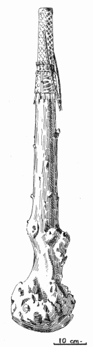
Bows and arrows were the principal weapons of the Mandan. The heads of the arrows, at the time of Maximilian's stay among the people, were made of thin bits of iron, although persons then living remembered the use of stone. Lances and clubs were likewise made and used, and when mentioning the latter Maximilian said, "a simple, knotty, wooden club is called mauna-panischa," and gives, on page 390, a woodcut of such a weapon. It is of interest to know that an example of this peculiar form of weapon, which at once suggests the traditional club of Hercules, is preserved in the Museo Kircheriana, in Rome. It is one of four specimens now belonging to the museum which were collected by Maximilian, the other three being a knife sheath, a horse bridle, and a saddle blanket, all being beautifully decorated with colored quillwork. The club is shown in figure 9, after a drawing made for the writer in 1905 by Dr. Paribeni, of the museum. The smaller end is bound or braided with tanned skin, to serve as a handle, and around the upper end of the wrapping is a band of quillwork similar in workmanship to that on the other objects. All are remarkably well preserved, and several specimens in the Ethnological Museum in Florence may have belonged to the Maximilian collection.
Fig. 9.—Wooden club.
The Mandans, like other tribes of the upper Missouri Valley, were very expert in the art of dressing skins, especially those of the buffalo. They used two forms of implements, one of which is similar to those shown in plate 12, a; the second, rather more complicated, is represented in plate 34, c. This is a beautiful old specimen now in the National Museum. The handle is formed of a piece of elk antler; the blade is of clear, brownish flint, well chipped. Other similar objects are preserved in the collection.
How fortunate it was that Catlin and Maximilian chose to spend much time among the Mandan during the years 1832, 1833, and 1834. A few years later, in the spring of 1837, the dreaded smallpox swept away the greater part of this most interesting nation, and "when the disease had abated, and when the remnant of this once powerful nation had recovered sufficiently to remove the decaying bodies from their cabins, the total number of grown men was twenty-three, of women forty, and of young persons sixty or seventy. These were all that were left of the eighteen hundred souls that composed the nation prior to the advent of that terrific disease, and even those that recovered were so disfigured as scarcely to be recognized." (Hayden, (1), p. 433.) Soon those who survived deserted their old village near Fort Clark and removed a few miles above, and the town was, about this time, occupied by the Arikara. It is interesting to know that the small remnant of the Mandan continued to follow their own peculiar customs and to maintain their tribal unity although so reduced in numbers. It will not be necessary in the present sketch to trace the later history of the tribe.
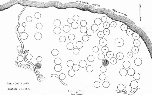
In recent years the State Historical Society of North Dakota has caused surveys to be made of the more important village sites in that State. In addition to the plans of the sites, showing the position of the earth lodges, they have been fortunate in obtaining drawings of the Mandan and Hidatsa villages, made by a Mandan living on the Fort Berthold Reservation. In writing of the picture and plan of the "most important historical site of the Mandan tribe in the state, the one visited and described by Lewis and Clark, Catlin, and Maximilian," Libby said: "The Indian chart and the map of the village as it appears to-day are here shown. It is seen that the two representations are not essentially unlike. The grouping of the houses about a common center, at one side of which is the holy tepee, is the predominating characteristic of each." The Indian drawing, although crude, shows some details omitted by Catlin in his many sketches; but the map (fig. 10) is of the greatest interest. It shows the site near Fort Clark as it appeared about the year 1908, and to quote from the description: "In the center of the tepees, on the space devoted by the old Mandans to the 'big canoe' and cedar post of the 'elder man,' stands now a large tepee (shown in dotted outline) which was placed there by the Arikara who occupied the village after the small-pox scourge of 1837 had killed or driven away the original inhabitants." The structures surrounding the open space were occupied by the principal men of the village, and the names as given by Libby were secured by him from "Bad Gun, Rushing War Eagle, son of the Ma-ta-to-pe or Four Bears, whose portrait Catlin painted." In the list of names "Tepee No. 1 was the holy tepee and was also used by Lance Shoulder," and "No. 2 was occupied by Four Bears." The list includes fifteen names. At the time the survey was made the entire ditch could not be traced, but its general course could be followed, thus indicating the approximate boundary of the town, "beyond which only a few tepees are located." (Libby, (1), pp. 498-499.)
Fig. 10.—Plan of the Mandan village at Fort Clark.
When it is realized how little is known regarding the arrangement of the many ancient villages which once stood in the country east of the Mississippi, villages which in their time were probably as large and important as those of the Mandan of the last century, it is not possible to overestimate the value of the work of the Historical Society in causing to be made an accurate survey of the sites and in securing descriptions of the villages from some who remember them. A generation later this would not have been possible.
hidatsa group.
Two tribes are regarded as constituting this group: The Hidatsa proper, known to the earlier writers as the Minnetarees, and to others as the Gros Ventres of the Missouri; and the Crows. The Hidatsa and the Crows were, until a few generations ago, one people, but trouble developed and the latter moved farther up the Missouri to the Rocky Mountains, and there they were discovered by the early explorers of the region.
The Amahami may have been a distinct tribe, and as such were recognized by Lewis and Clark, but according to their own traditions they, together with the Hidatsa and Crows, once formed a single tribe. Their language differs only slightly from that of the Hidatsa. During the early years of the last century their one village stood at the mouth of Knife River. Already greatly reduced in numbers, they suffered during the epidemic of 1837, and later the majority of those who had survived became more closely associated with the Hidatsa.
Hidatsa.
The Hidatsa, also known as the Minnetarees and designated by some writers the Gros Ventres of the Missouri, a name which must not be confused with Gros Ventres of the Prairie often applied to the Atsina, lived when first known to Europeans near the junction of the Knife and Missouri Rivers, in the eastern part of the present Mercer County, North Dakota. Some are of the belief that it was the Hidatsa and not the Mandan whom the French, under La Verendrye, visited during the autumn and winter of 1738, but in the present sketch the Mandan are accepted as undoubtedly being the tribe at whose villages the French remained.
The Hidatsa villages as seen by Catlin and Maximilian during the years 1832, 1833, and 1834 had probably changed little since the winter of 1804-05, when Lewis and Clark occupied Fort Mandan, their winter quarters, some 8 miles below the mouth of Knife River. Describing the villages, Catlin said the principal one stood on the bank of Knife River and consisted of 40 or 50 earth-covered lodges, each from 40 to 50 feet in diameter, and this town being on an elevated bank overlooked the other two which were on lower ground "and almost lost amidst their numerous corn fields and other profuse vegetation which cover the earth with their luxuriant growth.
"The scenery along the banks of this little river, from village to village, is quite peculiar and curious; rendered extremely so by the continual wild and garrulous groups of men, women, and children, who are wending their way along its winding shores, or dashing and plunging through its blue waves, enjoying the luxury of swimming, of which both sexes seem to be passionately fond. Others are paddling about in their tub-like canoes, made of the skins of buffaloes." (Catlin, (1), I, p. 186.) Among the great collection of Catlin's paintings belonging to the United States National Museum, in Washington, is one of the large village. The original painting is reproduced in plate 43. A drawing of the same was shown as plate in Catlin's work cited above. The work is crude but interesting historically, and conveys some idea of the appearance of the town, although in this, as in other paintings by the same artist, the earth lodges are very poorly drawn, failing to show the projection which served as the entrance and having the roofs too rounded and dome-shaped. Bodmer's sketches are far superior.
On June 19, 1833, Maximilian, aboard the steamboat Assiniboin, left Fort Clark bound for Fort Union at the mouth of the Yellowstone. Soon after passing the Mandan village of Ruhptare, so Maximilian wrote: "We saw before us the fine broad mirror of the river, and, at a distance on the southern bank, the red mass of the clay huts of the lower village of the Manitaries, which we reached in half an hour. The Missouri is joined by the Knife River, on which the three villages of the Manitaries are built. The largest, which is the furthest from the Missouri, is called Elah-Sa (the village of the great willows); the middle one, Awatichay (the little village), where Charbonneau, the interpreter, lives; and the third, Awachawi (le village des souliers), which is the smallest, consisting of only eighteen huts, situated at the mouth of Knife River.... The south bank of the river was now animated by a crowd of Indians, both on foot and on horseback; they were the Manitaries, who had flocked from their villages to see the steamer and to welcome us. The appearance of this vessel of the Company, which comes up, once in two years, to the Yellow Stone River, is an event of the greatest importance to the Indians.... The sight of the red brown crowd collected on the river side, for even their buffalo skins were mostly of this colour, was, in the highest degree, striking. We already saw above a hundred of them, with many dogs, some of which drew sledges, and others, wooden boards fastened to their backs, and the ends trailing on the ground, to which the baggage was attached with leather straps." (Maximilian, (1), pp. 178-179.)
BUREAU OF AMERICAN ETHNOLOGY BULLETIN 77 PLATE 44
a. Original pencil sketch
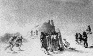
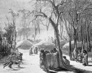
b. Finished picture of the same "WINTER PICTURE OF THE MINATARRES Karl Bodmer, 1833
BUREAU OF AMERICAN ETHNOLOGY BULLETIN 77 PLATE 45
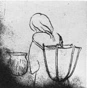
a. Manner of carrying basket similar to that shown in plate 52, a
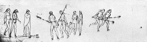
The ring-and-pole game.
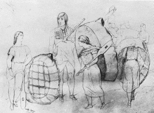
c. Hidatsa group with bull-boats. At Fort Berthold, July 13, 1851 FROM KURZ'S SKETCHBOOK
As told in the preceding section, Maximilian returned from Fort Union to Fort Clark, where, with the artist Bodmer, he spent the long winter. While near the Mandan towns he made several visits to the Hidatsa villages a few miles above, and learned much of the manners and ways of life of the people. He again spoke of the three villages on the banks of Knife River, "two on the left bank, and the third, which is much the largest, on the right bank." He continued: "At present the Manitaries live constantly in their villages, and do not roam about as they formerly did, when, like the Pawnees and other nations, they went in pursuit of the herds of buffaloes as soon as their fields were sown, returned in the autumn for the harvest, after which they again went into the prairie. In these wanderings they made use of leather tents, some of which are still standing by the side of their permanent dwellings" (p. 395). He then described the dress and general appearance of the people and continued: "The Manitari villages are similarly arranged as those of the Mandans, except that they have no ark placed in the central space, and the figure of Ochkih-Hadda is not there. In the principal village, however, is the figure of a woman placed on a long pole, doubtless representing the grandmother, who presented them with the pots, of which I shall speak more hereafter. A bundle of brushwood is hung on this pole, to which are attached the leathern dress and leggins of a woman. The head is made of wormwood, and has a cap with feathers. The interior of their huts is arranged as among the Mandans: like them the Manitaries go, in winter, into the forests on both banks of the Missouri, where they find fuel, and, at the same time, protection against the inclement weather. Their winter villages are in the thickest of the forest, and the huts are built near to each other, promiscuously, and without any attempt at order or regularity. They have about 250 or 300 horses in their three villages, and a considerable number of dogs" (pp. 396-397). Bodmer's picture of the "Winter Village of the Minatarres," made during the winter of 1833, is probably the most accurate drawing of an earth-lodge village in existence. It was given as plate xxvi by Maximilian, which is here reproduced as plate 44, b. A pencil sketch which may be considered as the original sketch made by Bodmer, and from which the finished picture was made, is now in the E. E. Ayer collection preserved in the Newberry Library. Unfortunately the drawing is unfinished but is very interesting historically. It is shown in plate 44, a.
Maximilian then referred briefly to the creation myth of the people with whom he was then resting. The entire surface was once covered with water. There were two beings: one a man who lived in the far Rocky Mountains who made all; the other was the old woman called grandmother by the members of the tribe. "She gave the Manitaries a couple of pots, which they still preserve as a sacred treasure," and "When their fields are threatened with a great drought they are to celebrate a medicine feast with the old grandmother's pots, in order to beg for rain: this is, properly, the destination of the pots. The medicine men are still paid, on such occasions, to sing for four days together in the huts, while the pots remain filled with water." Such were the superstitious beliefs of these strange people.
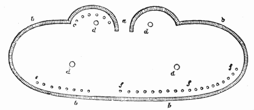
November 26, 1833, Maximilian, Bodmer, and several others went from Fort Clark to the winter village to attend "a great medicine feast among the Manitaries." They passed the two Mandan towns and during the journey saw a large stone, "undoubtedly one of those isolated blocks of granite which are scattered over the whole prairie, and which the Indians, from some superstitious notion, paint with vermilion, and surround with little sticks, or rods, to which were attached some feathers." The little party had seen much of interest on the way, and it was late in the day when they arrived at the village, "the large huts of which were built so close to each other that it was sometimes difficult to pass between them." Herds of buffalo having been reported in the vicinity of the village, a party of Indians had decided to start after them the following day, and planned "to implore the blessings of heaven upon their undertaking by a great medicine feast." This appears to have been a ceremony arranged by the women of the village. The structure in which the dance took place was not one of the earth-covered lodges of the town, but a rather temporary shelter of unusual shape. As described by Maximilian: "Between the huts, in the centre of the village, an elliptical space, forty paces or more in length, was enclosed in a fence, ten or twelve feet high, consisting of reeds and willow twigs inclining inwards. (See the woodcut.) [Fig. 11.] An entrance was left at a; b represents the fence; d are the four fires, burning in the medicine lodge, which were kept up the whole time. At e the elder and principal men had taken their seats; to the right sat the old chief, Lachpitzi-Sihrisch (the yellow bear); some parts of his face were painted red, and a bandage of yellow skin encircled his head. Places were assigned to us on the right hand of the yellow bear. At f, close to the fence, the spectators, especially the women, were seated: the men walked about, some of them handsomely dressed, others quite simply; children were seated round the fires, which they kept alive by throwing twigs of willow trees into them." Here follows a description of the ceremony, and it is related how six elderly men who had been chosen by the younger ones to represent buffalo bulls, entered the inclosure. They came from the hut opposite and when they were within, and after certain formalities, were seated at c. The ceremony was attended by smoking, the pipes were "brought first to the old men and the visitors; they presented the mouth-piece of the pipe to us in succession, going from right to left: we each took a few whiffs, uttered, as before, a wish or prayer, and passed the pipe to our next neighbours.... The six buffalo bulls, meantime, sitting behind the fire, sang, and rattled the medicine sticks, while one of them constantly beat the badger skin. After a while they all stood up, bent forward, and danced; that is, they leaped as high as they could with both their feet together, continuing to sing and rattle their sticks, one of them beating time on the badger. Their song was invariably the same, consisting of loud, broken notes and exclamations. When they had danced for some time, they resumed their seats.
Fig. 11.—Plan of a ceremonial lodge.
"The whole was extremely interesting. The great number of red men, in a variety of costumes, the singing, dancing, beating the drum, &c., while the lofty trees of the forest, illumed by the fires, spread their branches against the dark sky, formed a tout ensemble so striking and original, that I regretted the impracticability of taking a sketch of it on the spot."
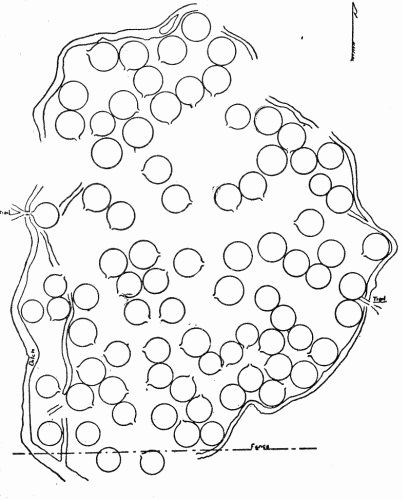
Fig. 12.—Plan of the large Hidatsa village.
Two days after the dance, on November 28, 1833, Maximilian visited the chief Yellow Bear in his lodge. The interior presents an interesting appearance: "The beds, consisting of square leathern cases, were placed along the sides of the spacious hut, and the inmates sat round the fire variously occupied. The Yellow Bear, wearing only his breech-cloth, sat upon a bench made of willow boughs, covered with skins, and was painting a new buffalo robe with figures in vermillion and black, having his colours standing by him, ready mixed, in old potsherds. In lieu of a pencil he was using the more inartificial substitute of a sharp-pointed piece of wood. The robe was ornamented with the symbols of valuable presents which he had made, and which had gained the Yellow Bear much reputation, and made him a man of distinction." (Maximilian, (1), pp. 419-423.)
Among the historic village sites which have been studied and surveyed by the State Historical Society of North Dakota, as mentioned in the preceding sketch of the Mandan, was that "of the largest Hidatsa village on Knife river." The map made for the society is here reproduced in figure 12. This, to quote Libby, "shows the present appearance of the ... largest Hidatsa village site, located just north of the mouth of Knife river. From the position and direction of the doorways, it is seen that these villages show no such large grouping as is characteristic of the Mandan village...." It was observed that the circles marking the positions of the earth lodges were much deeper in the Hidatsa villages than in the two Mandan sites. In the former the extreme depth below the "highest part of the rim was often three feet and very commonly over two feet," but on the Mandan sites the depressions were quite shallow. And "in many cases it was observed that in and near the Hidatsa villages were mounds of debris of varying heights, while nothing of the kind was seen on or near Mandan sites." (Libby, (1), p. 500.) Noting these characteristic features of the two groups of villages, or rather of the villages of the two tribes, should reduce the difficulty of identifying other ancient sites in the upper Missouri Valley.
The several quotations already made refer to the earth-covered lodges of the Hidatsa, but the same people also made use of the typical skin tipi, although less often mentioned by the early writers. They probably resembled the structures used by the Crow. On November 8, 1833, when Maximilian was returning to Fort Clark from the mouth of the Yellowstone, he wrote: "At twelve o'clock we were opposite the first Manitari summer village, and saw, on the other side, many Indians.... The invitations to land became more vociferous and numerous." Going ashore "we were immediately conducted, by a distinguished man, Ita-Widahki-Hisha (the red shield), to his tent, which stood apart on the prairie, on the summit of the bank. The white leather tent was new, spacious, and handsomely ornamented with tufts of hair of various colours, and at each side of the entrance, finished with a stripe and rosettes of dyed porcupine quills, very neatly executed. It had been well warmed by a good fire, a most refreshing sight to us. We took our seats around it, with the numerous family, the brother and uncle of the chief, young men, women, and children. The chief had rather a long beard, like the Punca chief, Shudegacheh, and his right breast was tattooed with black stripes.... A large dish of boiled maize and beans was immediately set before us; it was very tender and well dressed, and three of us eat out of the dish with spoons made of the horn of buffalo, or bighorn; after which the red Dacota pipe went round." (Maximilian; (1), p. 316.) This must have been a beautiful example of the buffalo-skin tipi, new and white, decorated with quillwork and tufts of hair.
Continuing down the Missouri to Fort Clark they passed women in their "round leather boats," and saw others, "proceeding towards the river, with their boats hanging on their heads and down their backs."
An example of a "bull-boat" and paddle is shown in plate 35, b. It was collected among the Hidatsa and is now preserved in the collection of the National Museum. It is a specimen of great interest and rarity, though once so extensively used by the tribes of the Missouri Valley. Several boats of this sort are shown by Bodmer in his picture of the Mandan village (pl. 39), and Kurz likewise left many drawings of these peculiar craft (pl. 45, c).
In addition to the several forms of structures already mentioned, the Hidatsa evidently erected a very secure temporary lodge when away from their villages on hunting trips. On November 7, 1833, when descending the Missouri, and just before arriving at Fort Clark, Maximilian wrote: "Our breakfast was prepared at nine o'clock, when we lay to on the north bank, in a narrow strip of forest, where we found some old Indian hunting lodges, built, in a conical form, of dry timber. They had, doubtless, been left by the Manitaries, who had come thus far on their hunting excursions. The lower part of the huts, or lodges, was covered with the bark of trees; the entrance was square, and bones were scattered in all directions. We proceeded with a bleak, high wind, saw the singular clay tops of the hills, and, in the forest, the stages made of poles, where the Indian hunters dry the flesh of the animals they have taken in the chase. About twelve o'clock we came to the spot where some stakes indicated the former site of a Mandan village.... We are now in the centre of the territory of the Manitaries." (Maximilian, (1), pp. 314-315.) Probably the danger of attack by their enemies made necessary the erection of these comparatively secure shelters.
About the year 1845 many Hidatsa removed from the vicinity of Knife River and reared a new village not far from Fort Berthold, some 60 miles up the Missouri from old Fort Clark. They were joined from time to time by other members of their tribe, and also by many of the remaining Mandan. In 1862 the Arikara became the third tribe to settle near Fort Berthold. But in 1850 the Arikara continued to occupy the old Mandan town just below Fort Clark, the large village of earth lodges so often visited and mentioned by the explorers and traders during the early years of the last century. It is quite evident the new settlement of the Hidatsa did not differ in appearance from the old Mandan town, the later home of the Arikara, and on June 13, 1850, Culbertson wrote from Fort Berthold: "The village, with its mud lodges, differs nothing in looks from the Ree village described yesterday, except in one particular, that is, the inhabitants are now engaged in surrounding it with pickets. The logs are well prepared and are all up except on the west side; a bastion with loop holes is placed in the middle of each side. This picket is of course to protect the inmates against enemies by whom they are frequently attacked." (Culbertson, (1), pp. 118-119.) This is a most interesting reference. Could this palisade have been the one to which Matthews alluded as having stood until 1865? The manner of constructing the palisade, with "a bastion ... in the middle of each side," will tend to recall the similar arrangement as indicated on the drawing of the ancient Mahican village about two centuries before. (Bushnell, (1), p. 26.)
In the autumn of 1853, just 20 years after Maximilian was among the Hidatsa, an officer passed down the Missouri from Fort Benton to St. Louis, thence to continue to Washington, where he arrived November 21. In his journal are several brief references to the Hidatsa, or, as he designated the tribe, the Gros Ventres. To quote from the journal: "October 8 ... a fine region, full of game, and occasionally speaking a hunting party of Gros Ventres out after buffalo." The next day the small party arrived at Fort Berthold, late in the afternoon. Then, so the journal continues: "We received many visits from the Gros Ventres, and gave them a few presents. The Gros Ventres have a large village of mud houses—very unsightly outside, but within warm and comfortable." The following morning, October 10, 1853, "I visited some of the lodges of the Gros Ventres, and found them exceedingly comfortable and capable of accommodating comfortably a hundred persons. One part of the lodge is appropriated to the horses, dogs, cattle, and chickens, and another to their own sleeping apartments. They all seemed to live sociably and comfortable together during the long cold winters of this cold latitude.... We left Fort Berthold early; but, before we had advanced far, were driven ashore by a strong wind, which continued throughout the day. The smoke from the burning prairies is so dense as to almost hide the sun. The fires, burning in every direction, present at night a beautiful and magnificent, though terrible appearance." (Saxton, (1), pp. 264-265.) What a vivid, though brief, description of conditions in the Upper Missouri Valley when all was in a primitive state.
During the years following the visits of Catlin and Maximilian many changes took place in the native villages standing on the banks of the upper Missouri and its tributaries. Writing of a period about 40 years after Maximilian's stay among the Mandan and Hidatsa, the winter of 1833-34, Dr. Matthews said: "The Hidatsa, Minnetaree, or Grosventre Indians, are one of the three tribes which at present inhabit the permanent village at Fort Berthold, Dakota Territory, and hunt on the waters of the Upper Missouri and Yellowstone Rivers, in Northwestern Dakota and Eastern Montana." Describing the village, he continued: "The village consists of a number of houses built very closely together, without any attempt at regularity of position. The doors face in every possible direction; and there is great uniformity in the appearance of the lodges; so it is a very difficult matter to find one's way among them." In a footnote to this paragraph is given the number of structures standing there in the year 1872. The note reads: In the fall of 1872, Dr. C. E. McChesney, then physician at the Berthold agency, counted, with great care, the buildings in the village and, in a letter, gave me the following results:
Old-style (round) lodges of Rees43
Log-cabins of Rees28
—
Total number of houses of Rees 71
Old-style lodges of Grosventres and Mandans35
Log-cabins of Grosventres and Mandans69
—
Total number of houses of Grosventres and Mandans 104
—
Total of houses in village 175
The note states that "owing to the stupidity of the interpreter" it was not possible to separate the Grosventres from the Mandans, which was to be regretted.
The "old-style lodges" were the earth-covered lodges, and Matthews follows with an excellent description of how they were constructed. He tells of the building of the frame, "covered with willows, hay, and earth," and over the opening in the center of the top "of many of the lodges are placed frames of wicker-work, on which skins are spread to the windward in stormy weather to keep the lodges from getting smoky. Sometimes bull-boats are used for this purpose." (Matthews, (1), pp. 3-6.) A comment on the work of the early artists is worthy of being mentioned at this time: "Prince Maximilian's artist [Karl Bodmer] usually sketches the lodge very correctly; but Mr. Catlin invariably gives an incorrect representation of its exterior. Whenever he depicts a Mandan, Arickaree, or Minnetaree lodge, he makes it appear as an almost exact hemisphere, and always omits the entry." (Op. cit., p. 6.)
Game, especially the buffalo, was becoming less plentiful in the vicinity of the villages, and Matthews told how, "Every winter, until 1866, the Indians left their permanent village, and, moving some distance up the Missouri Valley, built temporary quarters, usually in the center of heavy forests and in the neighborhood of buffalo.... The houses of the winter-villages resembled much the log-cabins of our own western pioneers. They were neatly built, very warm, had regular fire-places and chimneys built of sticks and mud, and square holes in the roofs for the admission of light." About that time some cabins of this sort were erected "in the permanent village at Fort Berthold; every year since, they are becoming gradually more numerous and threaten to eventually supplant the original earth-covered lodges." And in 1877 "game has recently become very scarce in their country, they are obliged to travel immense distances, and almost constantly, when they go out on their winter-hunts. Requiring, therefore, movable habitations, they take with them, on their journeys, the ordinary skin-lodges, or 'tepees,' such as are used by the Dakotas, Assiniboines, and other nomadic tribes of the region." (Op. cit., pp. 6-7.)
Matthews's description of the caches prepared by the tribes with whom he was so closely associated is most interesting, and it tends to explain the origin and use of the numerous pits often discovered in the vicinity of ancient village sites east of the Mississippi. He wrote: "The numerous caches, or pits, for storing grain, are noteworthy objects in the village. In summer, when they are not in use, they are often left open, or are carelessly covered, and may entrap the unwary stroller. When these Indians have harvested their crops, and before they start on their winter-hunt, they dig their caches, or clear out those dug in previous years. A cache is a cellar, usually round, with a small opening above, barely large enough to allow a person to descend; when finished, it looks much like an ordinary round cistern. Reserving a small portion of corn, dried squash, etc., for winter use, they deposit the remainder in these subterranean store-houses, along with household-utensils, and other articles of value which they wish to leave behind. They then fill up the orifices with earth, which they trample down and rake over; thus obliterating every trace of the excavation. Some caches are made under the floors of the houses, others outside, in various parts of the village-grounds; in each case, the distance and direction from some door, post, bedstead, fire-place, or other object is noted, so that the stores may be found on the return of the owners in the spring. Should an enemy enter the village while it is temporarily deserted, the goods are safe from fire and theft. This method of secreting property has been in use among many tribes, has been adopted by whites living on the plains, and is referred to in the works of many travelers." (Op. cit., pp. 8-9.)
Such were the characteristic features of the Hidatsa villages.
Crows.
Before the separation of the Crows from the Hidatsa they may have occupied permanent villages of earth-covered lodges, such as the latter continued to erect and use until very recent years. But after the separation the Crows moved into the mountains, the region drained by the upper tributaries of the Missouri, and there no longer built permanent structures but adopted the skin tipi, so easily erected and transported from place to place. Many of their tipis were very large, beautifully made and decorated, and were evidently not surpassed in any manner by the similar structures constructed by other tribes of the Upper Missouri Valley.
During the summer of 1805 François Antoine Larocque, a clerk attached to the Upper Red River Department of the Compagnie du Nord-Ouest, visited the Crows and in his journal recorded much of interest respecting the manners of the people. Larocque had, during the winter of 1804-05, remained near the Mandan and Hidatsa villages, and thus met Captains Lewis and Clark in their winter encampment. A large party of the Crows, the Rocky Mountain Indians of the journal, came to the Hidatsa villages on Knife River. There they were met by Larocque, with whom they departed for their distant country, on Saturday, June 29, 1805. His narrative contains a brief reference to the people. He wrote: "This nation known among the Sioux by the name of Crow Indians inhabit the eastern part of the Rocky Mountains at the head of the River aux Roches Jaunes (which is Known by the Kinistinaux and Assiniboines by the name of River a la Biche, from the great number of elks with which all the Country along it abounds) and its Branches and Close to the head of the Missouri.
"There are three principal tribes of them whose names in their own language are Apsarechas, Keetheresas and Ashcabcaber, and these tribes are again divided into many other small ones which at present consist but of a few people each, as they are the remainder of a numerous people who were reduced to their present number by the ravage of the Small Pox, which raged among them for many years successively and as late as three years ago. They told me they counted 2000 Lodges or tents in their Camp when all together before the Small Pox had infected them. At present their whole number consist of about 2400 persons dwelling in 300 tents and are able to raise 600 Wariors like the Sioux and Assiniboines. They wander about in Leather tents and remain where there are Buffaloes and Elks. After having remained a few days in one place so that game is not more so plentiful as it was they flit to another place where there are Buffaloes or deers and so on all the year around. Since the great decrease of their numbers they generally dwell all together and flit at the same time and as long as it is possible for them to live when together they seldom part." (Larocque, (1), pp. 55-56.) The narrative continues: "They live upon Buffaloes & Deer, a very few of them eat Bears or Beaver flesh, but when compelled by hunger; they eat no fish." The Crows were at that time in their primitive condition. "They have never had any traders with them, they get their battle Guns, ammunitions etc. from the Mandans & Big Bellys in exchange for horses, Robes, Leggings & shirts, they likewise purchase corn, Pumpkins & tobacco from the Big Bellys as they do not cultivate the ground."
Unfortunately, Larocque did not describe the appearance of the tipis, but such information was supplied by later writers.
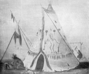
Catlin visited the Crows during the summer of 1832 and saw many who frequented Fort Union, at the mouth of the Yellowstone, during his stay at that post. He wrote at that time: "The Crows who live on the head waters of Yellow Stone, and extend from this neighborhood also to the base of the Rocky Mountains, are similar ... to the Blackfeet: roaming about a great part of the year." And describing their habitations, he said: "The Crows, of all the tribes in this region, or on the Continent, make the most beautiful lodge ... they construct them as the Sioux do, and make them of the same material; yet they oftentimes dress the skins of which they are composed almost as white as linen, and beautifully garnish them with porcupine quills, and paint and ornament them in such a variety of ways, as renders them exceedingly picturesque and agreeable to the eye. I have procured a very beautiful one of this description, highly ornamented, and fringed with scalp-locks and sufficiently large for forty men to dine under. The poles which support it are about thirty in number, of pine, and all cut in the Rocky Mountains.... This tent, when erected, is about twenty-five feet high." (Catlin, (1), I, pp. 43-44.) Catlin's original painting of this most interesting tipi is in the National Museum, Washington, and is here reproduced in plate 46, a. The same was drawn and given by Catlin as plate 20 in his work.
BUREAU OF AMERICAN ETHNOLOGY BULLETIN 77 PLATE 46
a. "Crow lodge." George Catlin
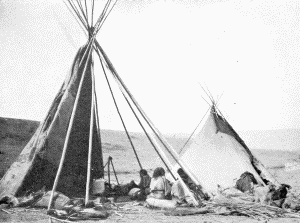
b. Crow camp at the old agency on the Yellowstone, near Shields River. Photograph by W. H. Jackson, 1871 CROW TIPIS
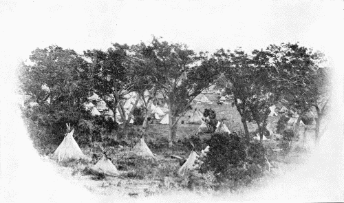
BUREAU OF AMERICAN ETHNOLOGY BULLETIN 77 PLATE 47
A CAMP IN A COTTONWOOD GROVE Photograph not identified, but probably made by J. D. Hutton
As told elsewhere in this work, Maximilian, on June 18, 1833, arrived at Fort Clark. At that time representatives of several tribes were gathered in the vicinity of the fort. These included Crows, "of which tribe there were now seventy tents about the fort." Referring to these in particular, he remarked: "The tents of the Crows are exactly like those of the Sioux, and are set up without any regular order. On the poles, instead of scalps, there were small pieces of coloured cloth, chiefly red, floating like streamers in the wind." (Maximilian, (1), p. 172.) Later in the day Maximilian accompanied the Indian agent to the tipi occupied by the Crow chief Eripuass. This he found to be of much interest. "The interior of the tent itself had a striking effect. A small fire in the centre gave sufficient light; the chief sat opposite the entrance, and round him many fine tall men, placed according to their rank, all with no other covering than a breech-cloth. Places were assigned to us on buffalo hides near the chief, who then lighted his Sioux pipe, which had a long flat tube, ornamented with bright yellow nails, made each of us take a few puffs, holding the pipe in his hand, and then passed it round to the left hand." And speaking of the tribe as a whole he wrote: "The territory in which they move about is bounded, to the north or north-west, by the Yellow Stone River, and extends round Bighorn River, towards the sources of Chayenne River and the Rocky Mountains. These Indians are a wandering tribe of hunters, who neither dwell in fixed villages, like the Mandans, Manitaries, and Arikkaras, nor make any plantations except of tobacco, which, however, are very small.... They roam about with their leather tents, hunt the buffalo, and other wild animals, and have many horses and dogs, which, however, they never use for food.... The Crow women are very skilful in various kinds of work, and their shirts and dresses of bighorn leather, embroidered and ornamented with dyed porcupine quills, are particularly handsome, as well as their buffalo robes, which are painted and embroidered in the same manner." (Op. cit., pp. 174-175.)
During the spring of 1863 a peculiar type of log house was discovered in the Crow country which had probably been erected by members of that tribe. They may have resembled the cabins mentioned by Matthews as standing at the Fort Berthold Reservation nine years later. On May 2, 1863, a member of the Yellowstone expedition entered in his journal: "In the timber along the river, we saw many houses built of dry logs and bark; some are built like lodges, but the most of them are either square or oblong, and among them were many large and strong corrals of dry logs. The Crows evidently winter along here, and, from the sign, they are very numerous." The following day, "We camped three miles below Pompey's Pillar, on which we found the names of Captain Clark and two of his men cut in the rock, with the date July 25, 1806.... Buffalo to be seen in every direction, and very tame.... No wonder the Crows like their country; it is a perfect paradise for a hunter.... About sundown a large band of buffalo came in to drink at a water-hole about two hundred yards in front of our camp." (Stuart, (1), pp. 176-178.) This may have represented a winter camp ground, with permanent huts to which the Crows returned from year to year. It was in the northeastern part of the present Yellowstone County, Montana.
A very interesting description of a Crow camp is to be found in Lord Dunraven's narrative of his hunting trip to the Yellowstone region performed during the year 1874. The particular camp stood not far from the present Livingston, Montana. In describing the camp he wrote: "The lodges are tall, circular dwellings, composed of long fir-poles planted on a circle in the ground. These slope inwards and form a cone, meeting and leaning against each other at the apex; and upon them is stretched a covering of buffalo hides. They make very comfortable, clean and airy houses, and are far preferable to any tent, being much warmer in winter and cooler in summer. A tepee will hold from twelve to fifteen or even twenty individuals; several families, therefore, generally occupy one in common. The earth is beaten down hard, forming a smooth floor, and in the middle burns the fire, the smoke finding an exit through an aperture at the top. The portions of the tepee assigned to each family or couple are divided by a kind of wicker-work screen at the head and foot, separating a segment of a circle of about eight or ten feet in length and five or six in breadth, closed by the screen at either end, and at the outer side by the wall of the lodge, but being open towards the interior. The fire is common property, and has a certain amount of reverence paid to it. It is considered very bad manners, for instance, to step between the fire and the place where the head man sits. All round, on the lodge poles and on the screens, are suspended the arms, clothing, finery, and equipment of the men and their horses. Each lodge forms a little community in itself.
"The tepees are pitched with all the regularity of an organized camp, in a large circle, inside which the stock is driven at night or on an alarm or occasion of danger. Outside the door is struck a spear or pole, on which is suspended the shield of the chief and a mysterious something tied up in a bundle, which is great medicine." (Dunraven, (1), pp. 94-95.)
A white shield supported outside a tipi is visible in the photograph reproduced as plate 47. This remarkable picture has not, unfortunately, been identified, but it was undoubtedly made in the Upper Missouri Valley, and from the nature of the tipis, many appearing to be quite small, it may be assumed that it was a party of Indians who had come on a trading trip, rather than that it represented a regular village.
Several accounts are preserved of large structures discovered in the region frequented by the Crows which, although not positively identified, were possibly erected by members of that tribe. Thus Lewis and Clark on July 24, 1806, arrived at an island in the Yellowstone River between 5 and 6 miles below the mouth of Clark's Fork, and wrote: "It is a beautiful spot with a rich soil, covered with wild rye, and a species of grass like the blue-grass, and some of another kind, which the Indians wear in plaits round the neck, on account of a strong scent resembling that of vanilla. There is also a thin growth of cottonwood scattered over the island. In the centre is a large Indian lodge which seems to have been built during the last summer. It is in the form of a cone, sixty feet in diameter at the base, composed of twenty poles, each forty-five feet long, and two and a half in circumference, and the whole structure covered with bushes. The interior was curiously ornamented. On the tops of the poles were feathers of eagles, and circular pieces of wood, with sticks across them in the form of a girdle: from the centre was suspended a stuffed buffaloe skin; on the side fronting the door was hung a cedar bush: on one side of the lodge a buffaloe's head; on the other several pieces of wood stuck in the ground. From its whole appearance, it was more like a lodge for holding councils, than an ordinary dwelling house." (Lewis and Clark, (1), II, p. 386.) This was undoubtedly a ceremonial lodge, and it was probably quite similar to another observed a few years later. To quote the description of the second example: "In the country of the Crow Indians, (Up-sa-ro-ka,) Mr. Dougherty saw a singular arrangement of the magi. The upper portion of a cotton-wood tree was implanted, with its base in the earth, and around it was a sweat house, the upper part of the top of the tree arising through the roof. A gray bison skin, extended with oziers on the inside so as to exhibit a natural appearance, was suspended above the house, and on the branches were attached several pairs of children's mockasins and leggings, and from one of the limbs of the tree, a very large fan made of war eagle's feathers was dependent." (James, (1), I, p. 272.)
Caddoan tribes.
The ancient habitat of the many small tribes which evidently later became confederated, thus forming the principal groups of this linguistic stock, was in the southwest, whence the Pawnee and Arikara, and those gathered under the name of the Wichita, moved northward.
The Caddo proper, the name of a tribe later applied to the confederated group of which they formed the principal member, formerly occupied the valley of the Red River of Louisiana, the many villages of the several tribes being scattered along the banks of that stream and of its tributaries in northern Louisiana, southwestern Arkansas, and eastern Texas. Although usually included in the same linguistic group with the Pawnee, Arikara, Wichita, and others, several notable authorities are inclined to regard the Caddo as constituting a separate and distinct linguistic group. This may be established and recognized in the future.
pawnee.
Soon after the transfer of Louisiana to the United States Government several expeditions were sent out to explore the newly acquired domains and to discover the native tribes who claimed and occupied parts of the vast territory. Of these parties, that led by Capts. Lewis and Clark was the most important, but of great interest was the second expedition under command of Lieut. Z. M. Pike, which traversed the country extending from the Mississippi to the Rocky Mountains, and reached the Pawnee villages near the North Platte during the month of September, 1806. How long the Pawnee had occupied that region may never be determined, but they had evidently migrated from the southwest, probably moving slowly, making long stops on the way. As a tribe they were known to the Spaniards as early as the first half of the sixteenth century, and appear to have been among the first of the plains tribes to be visited by French and Spanish traders.
Unfortunately Pike did not prepare a very extensive account of the Pawnee as they appeared during the autumn of 1806, but wrote in part: "Their houses are a perfect circle, (except where the door enters) from whence there is a projection of about 15 feet; the whole being constructed after the following manner, Viz: 1st. there is an excavation of a circular form, made in the ground, of about 4 feet deep and 60 diameter, where there is a row of posts about 5 feet high, with crotches at the top, set firmly in all round, and horizontal poles from one to the other. There is then a row of posts, forming a circle of about 10 feet width in the diameter of the others, and 10 feet in height; the crotches of those are so directed, that horizontal poles are also laid from one to the other; long poles are then laid slanting, perpendicularly from the lower poles over the upper, and meeting nearly at the top, leaving only a small aperture for the smoke of the fire to pass out, which is made on the ground in the middle of the lodge. There is then a number of small poles put up round the circle, so as to form the wall, and wicker work run through the whole. The roof is then thatched with grass, and earth thrown up against the wall until a bank is made to the eves of the thatch; and that is also covered with earth one or two feet thick, and rendered so tight, as entirely to exclude any storm whatsoever, and make them extremely warm. The entrance is about 6 feet wide, with walls on each side, and roofed like our houses in shape, but of the same materials as the main building. Inside there are numerous little apartments constructed of wicker work against the wall with small doors; they have a great appearance of neatness and in them the members of the family sleep and have their little deposits. Their towns are by no means so much crowded as the Osage, giving much more space, but they have the same mode of introducing all their horses into the village at night, which makes it extremely crowded. They keep guards with the horses during the day. They are extremely addicted to gaming, and have for that purpose a smooth piece of ground cleared out on each side of the village for about 150 yards in length." (Pike, (1), Appendix, p. 15.)
Although Pike's account of this interesting tribe is very brief and unsatisfactory, it was soon to be followed by a more complete and comprehensive description. This refers to the notes prepared by members of the Long expedition, 14 years later.
The expedition under command of Maj. Stephen H. Long arrived at Council Bluff, "so called by Lewis and Clark, from a council with the Otoes and Missouries held there, on the 3rd of August, 1804," during the early autumn of 1819. Winter quarters were established at a point about 5 miles lower down the Missouri and at a short distance north of the present city of Omaha, Nebr. This was called Engineer Cantonment, and during the ensuing months many Indians visited the encampment to treat with Maj. O'Fallon, the commissioner.
Leaving the majority of the party in quarters at the cantonment, Maj. Long and others of the expedition, on October 11, "began to descend the Missouri in a canoe, on their way towards Washington and Philadelphia." Returning from the east they reached Engineer Cantonment May 28, 1820, having arrived at St. Louis April 24, "from Philadelphia to Council Bluff, to rejoin the party."
During the absence of the commanding officers some members of the expedition made a short trip to the Pawnee villages, and the following brief account appears in the narrative on May 1, 1820:
"At each of the villages, we observed small sticks of the length of eighteen inches or two feet, painted red, stuck in the earth in various situations, but chiefly on the roofs of the houses, each bearing the fragment of a human scalp, the hair of which streamed in the wind. Before the entrance to some of the lodges were small frames, like painter's easels, supporting each a shield, and generally a large painted cylindrical case of skin, prepared like parchment, in which a war dress is deposited. The shield is circular, made of bison skin, and thick enough to ward off an arrow, but not to arrest the flight of a rifle ball at close quarters.... The lodges, or houses, of these three villages, are similar in structure, but differ in size. The description of those of the Konzas will apply to them, excepting that the beds are all concealed by a mat partition, which extends parallel to the walls of the lodge, and from the floor to the roof. Small apertures, or doors, at intervals in this partition, are left for the different families, that inhabit a lodge, to enter their respective bed chambers." (James, (1), pp. 367-368.)
After the return of Maj. Long the reunited party left Engineer Cantonment, June 6, 1820, and soon reached the Pawnee villages, situated about 100 miles westward, on the Loup River, a branch of the Platte. The narrative of this part of the journey is most interesting: "The path leading to the Pawnee villages runs in a direction a little south of west from the cantonment, and lies across a tract of high and barren prairie for the first ten miles. At this distance it crosses the Papillon, or Butterfly creek, a small stream discharging into the Missouri, three miles above the confluence of the Platte."
After advancing for several days over the prairie, on June 10, "At sunset we arrived at a small creek, eleven miles distant from the village of the Grand Pawnees, where we encamped. On the following morning, having arranged the party according to rank, and given the necessary instructions for the preservation of order, we proceeded forward and in a short time came in sight of the first of the Pawnee villages. The trace on which we had travelled since we left the Missouri, had the appearance of being more and more frequented as we approached the Pawnee towns; and here, instead of a single footway, it consisted of more than twenty parallel paths, of similar size and appearance.... After a ride of about three hours, we arrived before the village, and despatched a messenger to inform the chief of our approach. Answer was returned that he was engaged with his chiefs and warriors at a medicine feast, and could not, therefore, come out to meet us.... The party which accompanied Major Long, after groping about some time, and traversing a considerable part of the village, arrived at the lodge of the principal chief. Here we were again informed that Tarrarecawaho, with all the principal men of the village, were engaged at a medicine feast.
"Notwithstanding his absence, some mats were spread for us upon the ground, in the back part of the lodge. Upon these we sat down, and after waiting some time, were presented with a large wooden dish of hominy, or boiled maize. In this was a single spoon of the horn of a bison, large enough to hold half a pint, which, being used alternately by each of the party, soon emptied the dish of its contents."
An excellent example of an old spoon similar to the one mentioned in the preceding paragraph is shown in plate 42, a (U.S.N.M. 12259). It is about 10 inches in length and much worn from long use. Unfortunately it is not known when or where it was collected, but without doubt it came from the Upper Missouri Valley.
Continuing the narrative: "The interior of this capacious dwelling was dimly lighted from a hole at the top, through which the sun's rays, in a defined column, fell upon the earthen floor. Immediately under this hole, which is both window and chimney, is a small depression in the centre of the floor, where the fire is made; but the upper parts of the lodge are constantly filled with smoke; adding much to the air of gloominess and obscurity, which prevail within. The furniture of Long-hair's lodge consisted of mats, ingeniously woven of grass or rushes, bison robes, wooden dishes, and one or two small brass kettles. In the part of the lodge immediately opposite the entrance, we observed a rude niche in the wall, which was occupied by a bison skull. It appeared to have been exposed to the weather, until the flesh and periosteum had decayed, and the bones had become white....
"Our visit to this village seemed to excite no great degree of attention. Among the crowd, who surrounded us before we entered the village, we observed several young squaws rather gaily dressed, being wrapped in clean and new blankets, and having their heads ornamented with wreaths of gnaphalium and the silvery leaves of the prosalea canescens. On the tops of the lodges we also saw some display of finery, which we supposed to have been made on account of our visit. Flags were hoisted, shields, and bows, and quivers, were suspended in conspicuous places, scalps were hung out; in short, the people appeared to have exposed whatever they possessed, in the exhibition of which, they could find any gratification of the vanity. Aside from this, we received no distinguished marks of attention from the Grand Pawnees." (James, (1), I, pp. 427-437.)
The camp of the expedition was a little more than a mile from the village of the Grand Pawnee, and the intervening prairie must have presented an animated sight, being "covered with great numbers of horses, intermixed with men, women, and children." Nearer the village were groups of squaws "busily engaged in dressing the skins of the bison for robes." During the afternoon many Indians arrived at the camp, men wishing to trade horses, the women endeavoring to trade various articles. And on the following morning, June 11, 1820, many groups of women were seen leaving the village, accompanied by their dogs, bound for their fields of corn situated a few miles away.
The expedition next arrived at the village of the Republican Pawnee, 4 miles from that of the Grand Pawnee. Both villages stood on the immediate bank of the stream. Remaining there but a short time, they continued on to the Loup village. Here they encamped during the night of June 12, leaving early on the following morning. On the morning of the 13th many squaws were again observed making their way to the cornfields, with their small children. Some stopped to admire the "novel appearance" of the members of the expedition, many brought various vegetables, jerked buffalo meat and tallow to exchange for whatever they could obtain.
"The three Pawnee villages, with their pasture grounds, and insignificant enclosures, occupy about ten miles in length of the fertile valley of the Wolf river. The surface is wholly naked of timber, rising gradually to the river hills, which are broad and low, and from a mile to a mile and a half distant." (James, (1), I, p. 447.)
During the latter part of the summer of 1833 the small party under the leadership of Commissioner Henry L. Ellsworth reached the Pawnee towns, and in the narrative of the expedition are to be found many references to the customs of the people whose habitations were the primitive earth-covered lodges. The second morning after arriving at the village of the Grand Pawnee several members of the party walked about among the lodges, and at that time, so wrote Irving: "The warriors were collected in small knots of five or six, and by their vehement gestures, were apparently engaged in earnest conversation. The children were rolling and tumbling in the dirt; the squaws were busily engaged. Some were bringing from their lodges large leather sacks of shelled corn; others were spreading it out to dry, upon the leather of their buffalo-skin tents, which had been stretched out upon the ground. Others were cleansing from it the decayed kernels and packing it up in small sacks of whitish undressed leather, resembling parchment. These were then deposited in cache-holes for a winter's store.
"At a distance from the village, a band of females were slowly wending along the top of the low prairie ridges, to their daily labour in the small plantations of corn. These are scattered in every direction round the village, wherever a spot of rich, black soil, gives promise of a bountiful harvest. Some of them are as much as eight miles distant from the town." (Irving, J. T., (1), II, pp. 44-45.)
Later the same day a council was held at the lodge of the chief, attended by the principal men of the village, and it is interesting to read the description of the gathering of those who were to participate: "The lodge had been swept clean; a large cheery fire was crackling in the centre. The rabble crowd of loungers and hangers-on had been routed; and besides the family of the chief, we were the only occupants of the spacious building.
"At mid-day the chiefs and braves began to assemble. They were full dressed; many of the young warriors had spent the whole morning in preparation, and now presented themselves, fully ornamented for the meeting.
"As the hour for the opening of the council grew nearer, the tall, muffled warriors poured in, in one continuous stream. They moved quietly to the places allotted them, and seating themselves in silence round the chief, according to their rank.... The crowd continued flowing in until the lodge was filled almost to suffocation. As they came in, they seated themselves, until five or six circles were formed, one beyond the other, the last ranging against the wall of the building. In the ring nearest the chiefs, sat the principal braves, or those warriors whose deeds of blood entitled them to a high rank in the councils of the nation. The more distant circles were filled by such young men of the village as were admitted to its councils. The passage leading to the open air, was completely blocked up with a tight wedged mass of women and children, who dared venture no nearer to the deliberations of the tribe." (Op. cit., pp. 48-50.) When all had gathered the chief filled a large stone pipe, took a few puffs, then handed it to the members of the commissioner's party, who in turn passed it to the other Indians. The addresses were then made and the council deliberated on the several questions presented.
The expedition moved on from the Grand Pawnee to the village of the Republican Pawnee, which stood on the bank of the Loup Fork of the Platte, some 20 miles distant from the former, with the rolling prairie between. Approaching the river they could see, on the far side, "a high bluff, on which was situated the dingy lodges of the Republican village." They were welcomed by the people of the village, and soon reached the lodge of the principal chief, Blue Coat, which they entered. Then "it was not long before the lodge became crowded. The old warriors moved with a hushed step across the building, and listened to our conversation." Soon an invitation was received to attend a feast at the lodge of the second chief. Entering that lodge, he was seen seated upon "a small leather mat.... Around him were lounging about a dozen Indians. Some, reclining with their backs against the pillars supporting the roof, with their eyes half closed, were smoking their stone pipes. Some were lying half asleep upon the clay floor, with their feet within a few inches of the fire; and others were keeping up a sleepy song.
"At a short distance from the fire, half a dozen squaws were pounding corn, in large mortars, and chattering vociferously at the same time. In the farther part of the building, about a dozen naked children, with faces almost hid by their bushy, tangled hair, were rolling and wrestling upon the floor, occasionally causing the lodge to echo to their childish glee. In the back ground, we could perceive some half dozen shaggy, thievish-looking wolf dogs, skulking among the hides and bundles, in search of food, and gliding about with the air of dogs, who knew that they had no business there." (Op. cit., pp. 96-99.) Such was a domestic scene within a Pawnee lodge.
A very clear and concise description of the interior arrangement and fittings of an earth lodge, one standing in the village of the Grand Pawnee during the autumn of 1835, has been preserved in Dunbar's journal. On October 22, after referring to the construction of the lodge itself, he wrote: "Within these buildings the earth is beat down hard, and forms the floor. In the center a circular place is dug about 8 inches deep, and 3 feet in diameter. This is the fireplace. The earth that is taken from this place is spatted down around it, and forms the hearth. Near the fireplace a stake is firmly fixed in the earth in an inclined position, and serves all the purposes of a crane. Mats made of rushes are spread down round the fire on which they sit. Back next the walls are the sleeping apartments. A frame work is raised about two feet from the floor, on this are placed small rods, interwoven with slips of elm bark. On these rods a rush mat is spread. At proper distances partitions are set up, composed of small willow rods interwoven with slips of bark. In front of these apartments, either a partition of willow rods is erected, or rush mats are hung up as curtains. But this is not always the case. In some lodges the simple platform alone is to be seen, without either partitions, or curtains. In others there is not even the platform, and the inmates sleep on the ground.
"In these lodges several families frequently live together. I believe there are as many as three different families in the lodge where I stop. Each family has its particular portion of the dwelling, and the furniture of each is kept separate." (Dunbar, (2), p. 600.) Comparing the two preceding accounts it is easy to visualize the interior of Pawnee earth lodges as they were nearly a century ago.
The preceding references to the women of the villages going early in the morning to their fields of corn recall a note in Fremont's journal a few years later. He wrote when returning from the mountains, on September 22, 1842, "We arrived at the village of the Grand Pawnees, on the right bank of the river [the Platte] about thirty miles above the mouth of the Loup fork. They were gathering in their corn, and we obtained from them a very welcome supply of vegetables." (Fremont, (1), p. 78.)
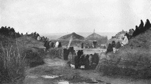
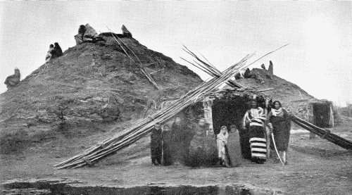
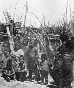
The villages described in the accounts already quoted were the permanent settlements of the tribe, groups of earth-covered lodges quite similar to those erected by other tribes in the Upper Missouri Valley. Fortunately several remarkable photographs of the villages and of the separate structures are in existence, having been made by W. H. Jackson in 1871. The most valuable of the early pictures is reproduced as plate 49. And here it may be remarked that this is a different photograph from the one which was presented as plate 12 in Bulletin 69 of this bureau's publications, and although both were made at the same time, nevertheless they differ in minor details. It is therefore of interest to know two negatives were made at that time. This was the village of the Republican Pawnee. In plate 50 are two of the large earth-covered lodges, showing the tunnel-like entrances, and with many persons sitting on the tops of the structures. The entrance is more clearly shown in plate 51, where a brush mat protects the side. This may be part of a small inclosure.
BUREAU OF AMERICAN ETHNOLOGY BULLETIN 77 PLATE 48
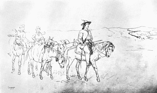
TRADER CROSSING THE PRAIRIES Page of Kurz's Sketchbook, August 28, 1851
BUREAU OF AMERICAN ETHNOLOGY BULLETIN 77 PLATE 49
PAWNEE-VILLAGE WHICH STOOD ON THE LOUPE FORK OF THE PLATTE RIVER Photograph by W. H. Jackson, 1871
BUREAU OF AMERICAN ETHNOLOGY BULLETIN 77 PLATE 50
LODGES IN THE PAWNEE VILLAGE WHICH STOOD ON THE LOUPE FORK OF THE PLATTE RIVER Photograph by W. H. Jackson, 1871
BUREAU OF AMERICAN ETHNOLOGY BULLETIN 77 PLATE 51
a. Children at lodge entrance
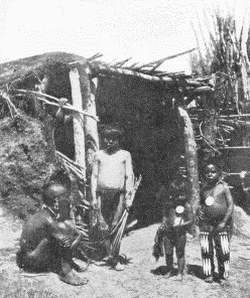
b. Showing screen near same entrance IN A PAWNEE VILLAGE Photographs by W. H. Jackson, 1871
In addition to the permanent earth-covered lodges the Pawnee made extensive use of temporary skin-covered shelters, unlike the conical lodge of the plains tribes. These served as their habitations during the hunting season, when away from their villages. A most valuable and interesting description of the ways and customs of the Pawnee while occupying their movable villages was prepared by one who, during the summer and autumn of 1835, lived among the people, sharing their primitive ways of life and thereby learning many of their peculiar traits. The English traveler, Charles A. Murray, whose narrative is quoted in part on the following pages, left Fort Leavenworth July 7, 1835, and two weeks later reached the summer camp of the Pawnee: "and a more interesting or picturesque scene I never beheld. Upon an extensive prairie gently sloping down to a creek, the winding course of which marked a broken line of wood here and there interspersed with a fine clump of trees, were about five thousand savages, inclusive of women and children; some were sitting under their buffalo-skin lodges lazily smoking their pipes; while the women were stooping over their fires busily employed in preparing meat and maize for these indolent lords of the creation. Far as the eye could reach, were scattered herds of horses, watched (or as we should say in Scotland, 'tented') by urchins, whose whole dress and equipment was the slight bow and arrow, with which they exercised their infant archery upon the heads of the taller flowers, or upon the luckless blackbird perched near them. Here and there might be seen some gay young warrior ambling along the heights, his painted form partially exposed to view as his bright scarlet blanket waved in the breeze." (Murray, (1), I, pp. 277-278.) Later he described the manner of moving and pitching their large temporary camps: "On reaching the camping-place, which is selected by the grand chief (or, in his absence, by the next in rank), the senior squaw chooses the spot most agreeable to her fancy, and orders the younger women and children, who lead the pack-horses and mules (generally from five to ten in number, according to the size or wealth of the family), to halt; but in making this choice of ground, she is restricted within certain limits, and those of no great extent, as the Pawnees observe great regularity both in their line of march and encampment. I could not ascertain whether these regulations were invariable, or made at the pleasure of the chief; but I believe the latter; and that on leaving their winter, or stationary, villages, he issues the general orders on this subject, which are observed during the season or the expedition; at any rate, they never varied during my stay among them.
"They move in three parallel bodies; the left wing consisting of part of the Grand Pawnees and the Tapages; the centre of the remaining Grand Pawnees; and the right of the Republicans.... All these bodies move in 'Indian file,' though of course in the mingled mass of men, women, children, and pack-horses, it was not very regularly observed; nevertheless, on arriving at the halting-place, the party to which I belonged invariably camped at the eastern extremity of the village, the great chief in the centre, and the Républiques on the western side; and this arrangement was kept so well, that, after I had been a few days with them, I could generally find our lodge in a new encampment with very little trouble, although the village consisted of about six hundred of them, all nearly similar in appearance.
"They first unpack and unsaddle the horses, which are given to a boy to drive off to their grass and water; they then arrange all their bales, saddles, &c. in a semi-circular form, and pile them from two to three feet high. Around the exterior of these they drive into the ground eight or ten curved willow rods, from two to three feet distant from each other, but all firmly bound by leather thongs to four large upright poles, that form the front of the lodge, and along which run transverse willow rods, to which the extremities of the curved ones are fastened. When the frame, or skeleton, is thus finished, they stretch the cover (made of buffalo hides, sewed together) tight over the whole, leaving an aperture for entrance and egress in the centre of the front; and in fine weather, the whole front open.
"This is an accurate description of a Pawnee summer-lodge; but, of course, the dimensions vary according to the number and wealth of the families residing therein; in some tents I have observed the front consisting of six or eight upright poles, to which were fixed more skins, for additional shelter or shade. On the grass, in the interior, are spread mats, made by the squaws from reeds, and skins of buffalo or bear.
"From the foregoing it will be easily understood that the bales of cloth, maize, skins, and whatever other property they possess, form the back of the tent. Each occupant, from the chief to the lowest in rank, has his assigned place; sleeps upon his own blanket, or buffalo robe; has his bow and quiver suspended over his head; his saddle, bridle, and laryettes, &c. behind his back: and thus little confusion prevails, although each individual has only just room to sit or lie at full length.
"Before the tent a kind of shield is raised, upon three poles pyramidically placed, on which is the device of the chief, by which his tent is to be recognised.... In the interior of the tent, and generally about the centre of its concave, is suspended the 'medicine,' which is most carefully and religiously preserved.... Under the head of 'medicine,' the Indians comprise not only its own healing department, but everything connected with religion of superstition; all omens, all relics, and everything extraordinary or supernatural." (Murray (1), I, pp. 282-286.)
Late in the year 1835 Murray left the Pawnee encampment to return to Fort Leavenworth, but, meeting with an accident, was not able to proceed on his way. The Pawnee were likewise moving, and in moving over the prairie made a well-defined trail. Retracing his way, and seeking the Pawnee, he wrote: "About ten o'clock on the following day we found the great Pawnee trail, and, following it, came at mid-day to the place where they had camped the night before, and a most hideous spectacle did it present; the grass was all trodden into mud—hundreds of circular heaps of charred wood attested the number of fires that had been used; and the whole plain was strewed with split heads, bare skeletons, and scattered entrails of buffalo; while some hundreds of the half-starved Pawnee dogs who had lingered behind the village were endeavoring to dispute some morsels of the carcasses with the gaunt snarling wolves, who were stripping the scanty relics of skin and sinew which are left by Indian butchery attached to the bone." (Op. cit., p. 438.) This vivid description of the appearance of an abandoned camp site quite agrees with a reference made by Dr. Grinnell a few years ago. Writing of events during the year 1853, and alluding to an abandoned camp of the Pawnee that year discovered by the Cheyenne, he said: "It was a big camp; and there were many fires. It seemed as if the Pawnees had been camped there killing buffalo for a long time. There were still many dogs in the camp. On one side was a well-beaten trail which led to another camp two hundred yards off where a number of people had been camped, not in lodges but in shelters made of willows bent over, after the fashion of a sweat-house." (Grinnell, (2), p. 86.)
These temporary and easily erected structures of the Pawnee were probably quite similar in form and appearance to that of the Cheyenne, part of which is shown in plate 14. But in the latter instance the cover is not formed of the primitive buffalo skin, but of canvas, or some other material obtained from the trader.
The Pawnee had a strange method of dealing with their sick or wounded during the movement of a village from place to place, and, so wrote Father De Smet, "if, in the long journeys which they undertake in search of game, any should be impeded, either by age or sickness, their children or relations make a small hut of dried grass to shelter them from the heat of the sun or from the weather, leaving as much provision as they are able to spare, and thus abandon them to their destiny.... If, some days after, they are successful in the chase, they return as quickly as possible to render assistance and consolation. These practices are common to all the nomadic tribes of the mountains." (De Smet, (2), pp. 356-357.) It is more than probable that similar grass shelters were constructed and used by small parties when away from the villages, but such structures would necessarily have been of only temporary use.
In addition to the semicircular skin-covered lodge mentioned by Murray, the Pawnee evidently made use of the conical tipi. This was described by Dunbar when he wrote: "Their movable dwellings consist of from 12 to 20 poles (the number varying with the size) about 16 feet long, and a covering. Three of these poles are tied together near the top and set up. The string, with which these poles are tied together, is so long that one end of it reaches to the ground, when the poles are set up. The other poles are now successively set up save one, the top of each leaning against the three, first set up, and forming with them a circle. The string is then wound round them all at the top several times and fastened. The cover is tied to the top of the remaining pole by which it is raised up, then is spread round them all and tied together on the opposite side, where is the entrance formed by leaving the cover untied about three feet from the ground. Over the entrance the skin of a bear or some other animal is suspended. The tents are always set up with their entrances toward the east. At the top the smoke passes out among the poles, a place being left for that purpose. The fire place, crane and hearth are similar to those in their fixed habitations. The furniture is placed back next the cover. Rush mats are then spread down forming a sort of floor. On these they sit, eat and sleep. The large tents are about 18 feet in diameter at the base. The tent covers are made of buffalo skins, scraped so thin as to transmit light, and sewed together. These when new are quite white, and a village of them presents a beautiful appearance. Some of them are painted according to Pawnee fancy. They carry their tent poles with them during their whole journey. From three to six of them, as the case may be, are tied together at the larger end, and made fast to the saddle, an equal number on each side, the other end drags on the ground." (Dunbar, (2), pp. 602-603.)
From these various records it will be understood the Pawnee made use of several forms of temporary and comparatively easily transported and erected structures when away from their permanent villages of earth-covered lodges. And what is true of the Pawnee would probably apply to other tribes of the upper Missouri Valley.
The Pawnee, as did other tribes of the region, made long journeys away from their villages in quest of the buffalo, and an interesting account of their annual hunts, as conducted about the year 1835, has been preserved. Then it was told how "The Pawnees make two hunts each year, the summer and winter hunt. To perform the winter hunt they leave their villages usually in the last week of October, and do not return to them again till about the first of April. They now prepare their cornfields for the ensuing season. The ground is dug up with the hoe, the corn is planted and well tended. When it has attained to a certain height they leave it, and go out to their summer hunt. This is done near the last of June. About the first of September they return to their villages. Formerly the buffalo came down to and far below their villages. Now they are obliged to travel out from ten to twenty days to reach them. The buffalo are rapidly diminishing and will in time become extinct.
"When they leave their villages to hunt the buffalo, they take every man and beast with them, and the place of their habitations is as desolate and solitary during their absence as any other spot on the prairie. When the time of departure arrives all the furniture and provisions they wish to carry with them are packed on the horses. The residue of their scant furniture and provisions are concealed in the earth till their return. As each family gets ready they fall into the train, which frequently extends some miles." (Dunbar, (1), pp. 329-330.) The narrative continues and relates many of the mannerisms of the people, and tells of their peculiar traits. And it is difficult to realize the great distance traveled during the hunting trips away from the permanent earth-lodge villages. Dunbar accompanied them on several of their hunts and wrote (Op. cit., p. 331): "The first hunting tour I performed with them they traveled, from the time they left their village till they returned to it again in the spring, about 400 miles. During the first summer hunt I was with them they traveled 700 miles before returning to their village. During my second winter hunt they traveled 900 miles, second summer hunt 800 miles."
The moving about over the vast rolling prairies of the people of an entire village, while on their distant hunts, covering many hundreds of miles, and carrying with them practically all of their belongings, with innumerable dogs and horses, stopping now to kill the buffalo and again pushing on in quest of more, constituted one of the most interesting and characteristic phases of primitive life on the prairies. But within a few decades all has changed, and now many towns and villages occupy the region once traversed by the roving bands.
arikara.
When or where the Arikara separated from their kindred tribe, the Pawnee, may never be determined, but during the years which followed the separation they continued moving northward, leaving ruined villages to mark the line of their migration. Sixty years ago it was said: "That they migrated upward, along the Missouri, from their friends below is established by the remains of their dirt villages, which are yet seen along that river, though at this time mostly overgrown with grass. At what time they separated from the parent stock is not now correctly known, though some of their locations appear to have been of very ancient date, at least previous to the commencement of the fur trade on the Upper Missouri. At the time when the old French and Spanish traders began their dealings with the Indians of the Upper Missouri, the Arikara village was situated a little above the mouth of Grand River, since which time they have made several removals and are now located at Fort Clark, the former village of the Mandans." (Hayden, (1), pp. 351-352.)
The beginning of the last century found the Arikara living in three villages, all on the right bank of the Missouri. In the journal of the French trader Le Raye are brief references to the villages, together with some notes on the manners and customs of the inhabitants. April 22, 1802, he wrote: "The Ricaras or Rus have three villages, situated on the south bank of the Missouri, in the great bend of the river. The lower village is on a large bottom covered with cotton wood, and contains about fifty huts." He then describes the manner in which the earth-covered lodges were built and refers to the structures being "placed with great regularity," a statement which does not seem to have been borne out by later writers. Continuing, he said: "The town is picketed with pickets twelve feet high and set very close, to prevent firing between them. There is one gate way, which is shut at night." On May 27, 1802, he left the lower village, "crossed Missouri, and arrived the same evening at the upper village. This village is situated on an Island in the Missouri, and is fortified in the same manner as the lower village, containing about sixty huts.... The next morning we proceeded, and soon left the Missouri, travelling a northwest course, in a well beaten path." (Le Raye, (1), pp. 171-180.)
Although the preceding notes may not be very accurate, nevertheless they are of interest on account of the period they cover, just before the transfer of Louisiana to the United States, and two years before the most important expedition ascended the Missouri.
To trace the sites of early Arikara villages as mentioned by Lewis and Clark, and as seen by them when the expedition under their command passed up the Missouri during the early autumn of 1804, is most interesting. On September 29 of that year they reached the mouth of a small creek which entered the Missouri from the south, "which we called Notimber creek from its bare appearance. Above the mouth of this stream, a Ricara band of Pawnees had a village five years ago: but there are no remains of it except the mound which encircled the town." This would have been in the present Stanley County, South Dakota. Two days later, on October 1, they "passed a large island in the middle of the river, opposite the lower end of which the Ricaras once had a village on the south side of the river: there are, however, no remnants of it now, except a circular wall three or four feet in height, which encompassed the town." Two miles beyond was the mouth of the Cheyenne River.
BUREAU OF AMERICAN ETHNOLOGY BULLETIN 77 PLATE 52
a. Arikara carrying basket. (U.S.N.M. 8430)
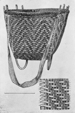
b. Wooden mortar. "Witchata Inds. Dr. E. Palmer." Height of body 13½ inches. (U.S.N.M. 6899)
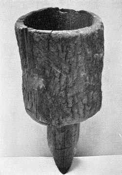
BUREAU OF AMERICAN ETHNOLOGY BULLETIN 77 PLATE 53
"RICCAREE VILLAGE" George Catlin
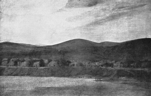
On the third day after passing the mouth of the Cheyenne they reached "Teal creek," and "A little above this is an island on the north side of the current, about one and a half mile in length and three quarters of a mile in breadth. In the centre of this island is an old village of the Ricaras, called Lahoocat; it was surrounded by a circular wall, containing seventeen lodges. The Ricaras are known to have lived there in 1797, and the village seems to have been deserted about five years since: it does not contain much timber."
On October 6, two days' travel beyond Teal Creek, and at a distance of about 32 miles above it, "We halted for dinner at a village which we suppose to have belonged to the Ricaras: it is situated in a low plain on the river, and consists of about eighty lodges, of an octagonal form, neatly covered with earth, and placed as close to each other as possible, and picketed round. The skin canoes, mats, buckets, and articles of furniture found in the lodges, induce us to suppose that it had been left in the spring. We found three different sorts of squashes growing in the village; we also killed an elk near it, and saw two wolves." On the following day, after advancing about 4 or 5 miles, they encountered "another village or wintering camp of the Ricaras, composed of about sixty lodges, built in the same form as those passed yesterday, with willow and straw mats, baskets, buffalo-skin canoes, remaining entire in the camp."
The baskets may have included many similar to two rare examples now in the National Museum, Washington, one of which is shown in plate 52, a (U.S.N.M. 8430).
On October 9, 1804, after passing the mouth of the river called by them the Wetawhoo or Wetarko, soon to be known as Grand River, which flows into the Missouri from the west in the present Corson County, South Dakota, the expedition stopped and held a council with the Indians. There they remained until October 11, when "At one o'clock we left our camp with the grand chief and his nephew on board, and at about two miles anchored below a creek on the south, separating the second and third village of the Ricaras, which are about half a mile distant from each other.... These two villages are placed near each other in a high smooth prairie; a fine situation, except that having no wood the inhabitants are obliged to go for it across the river to a timbered lowland opposite to them."
The expedition left the Arikara during the afternoon of October 12, and on that date in the narrative appears an interesting account of the then recent migrations of the tribe: "They were originally colonies of Pawnees, who established themselves on the Missouri, below Chayenne, where the traders still remember that twenty years ago they occupied a number of villages. From that situation a part of the Ricaras emigrated to the neighborhood of the Mandans, with whom they were then in alliance. The rest of the nation continued near the Chayenne till the year 1797, in the course of which, distressed by their wars with the Sioux, they joined their countrymen near the Mandans. Soon after a new war arose between the Ricaras and the Mandans, in consequence of which the former came down the river to their present position. In this migration those who had first gone to the Mandans kept together, and now live in the two lower villages, which may be considered as the Ricaras proper. The third village was composed of such remnants of the villages as had survived the wars, and as these were nine in number a difference of pronunciation and some difference of language may be observed between them and the Ricaras proper, who do not understand all the words of these wanderers. The villages are within the distance of four miles of each other, the two lower ones consist of between one hundred and fifty and two hundred men each, the third of three hundred." (Lewis and Clark, (1), I, pp. 92-104.) Following this, on page 106, is a brief description of the earth-covered lodges of the Arikara, which were of "a circular or octagonal form, and generally about thirty or forty feet in diameter," but a rather better description was prepared by one of the members of the expedition, Patrick Gass, who wrote on October 10: "This day I went with some of the men to the lodges, about 60 in number. The following is a description of the form of these lodges and the manner of building them.
"In a circle of a size suited to the dimensions of the intended lodge they set up 16 forked posts five or six feet high, and lay poles from one fork to another. Against these poles they lean other poles, slanting from the ground, and extending about four inches above the cross poles; these are to receive the ends of the upper poles that support the roof. They next set up four large forks, fifteen feet high, and about ten feet apart, in the middle of the area; and poles or beams between these. The roof poles are then laid on extending from the lower poles across the beams which rest on the middle forks, of such a length as to leave a hole at the top for a chimney. The whole is then covered with willow branches, except the chimney and a hole below to pass through. On the willow branches they lay grass and lastly clay. At the hole below they build a pen about four feet wide and projecting ten feet from the hut; and hang a buffalo skin at the entrance of the hut for a door. This labour like every other kind is chiefly performed by the squaws. They raise corn, beans and tobacco." (Gass, (1), p. 52.) And five days later Gass entered in his journal: "At 7 we saw a hunting party of the Rickarees, on their way down to the villages. They had 12 buffalo-skin canoes or boats laden with meat and skins; beside some horses that were going down the bank by land. They gave us a part of their meat. The party consisted of men, women, and children." (Op. cit., p. 54.)