VILLAGES AND FORMS OF STRUCTURES. (continued 2)
Reading edition
The preceding references would seem to apply to summer habitations, as distinguished from the mat-covered structures already mentioned. The descriptions are rather vague, and the lodges encountered by Schoolcraft may have been similar in form to that shown in plate 19. This most interesting and valuable photograph was made in the Indian Territory probably 40 years or more ago, and represents a rather large dwelling. It shows clearly the manner in which sheets of bark were placed and secured to serve as roof and sides, and in this instance the bark appears to be that of the elm.
Interesting notes on the manners and ways of life of the Sauk and Foxes just a century ago are to be found in a communication from Maj. M. Marston, of the Fifth Infantry, to Morse. Marston was commanding officer at Fort Armstrong, from which place the letter was written during the month of November, 1820. At that time the Fox village standing on the bank of the Mississippi, opposite Fort Armstrong, consisted of "thirty-five permanent lodges," and this may refer to the type of structures shown in plate 19. As Marston then wrote: "There is also a small Sauk village of five or six lodges on the west bank of the Mississippi, near the mouth of Des Moin river, and below Fort Edwards; and a Fox village near the lead mines (about a hundred miles above this place,) of about twenty lodges; and another near the mouth of the Wapsipinica of about ten lodges." Thus the villages and camps of the two tribes were to have been seen on both banks of the Mississippi, but undoubtedly the greater part of their hunting was done westward from the river, within the present State of Iowa. A century ago the people of the village would leave "as soon as their corn, beans, &c., are ripe and taken care of, and their traders arrive and give out their credit, (or their outfits on credit,) and go to their wintering grounds; it being previously determined in council, on what particular ground each party shall hunt. The old men, women, and children, embark in canoes; the young men go by land with their horses; on their arrival, they immediately commence their winter's hunt, which lasts about three months." The traders would follow and remain in convenient places. During the winter most of the Indians would pay their debts, get many necessary articles, and at the same time reserve the more valuable skins. These, "such as beaver, otter, &c., they take home with them to their villages, and dispose of for such articles as they may afterwards find necessary." The winter of 1819-20 was evidently a very prosperous one for the two tribes as well as for the traders, and Marston wrote: "These traders, including the peltries received at the United States Factory, near Fort Edwards, collected of the Sauk and Fox Indians during this season, nine hundred and eighty packs. They consisted of 2,760 beaver skins; 922 Otter; 13,440 Raccoon; 12,900 Musk Rat; 500 Mink; 200 Wild Cat; 680 Bear Skins; 28,600 Deer. Whole number, 60,082."
At the close of the winter hunt "they return to their villages, in the month of April, and after putting their lodges in order, commence preparing the ground to receive the seed. The number of acres cultivated by that part of the two nations, who reside at their villages in this vicinity, is supposed to be upwards of three hundred. They usually raise from seven to eight thousand bushels of corn, besides beans, pumpkins, melons, &c. About one thousand bushels of the corn they annually sell to traders and others; the remainder (except about five bushels for each family, which is taken with them,) they put into bags, and bury in holes dug in the ground, for their use in the spring and summer. The labor of agriculture is confined principally to the women, and this is done altogether with a hoe. In June, the greatest part of the young men go out on a summer hunt, and return in August. While they are absent the old men and women are collecting rushes for mats, and bark to make into bags for their corn, &c.
"The women usually make about three hundred floor mats every summer.... The twine which connects the rushes together, is made either of basswood bark, after being boiled and hammered, or the bark of the nettle; the women twist or spin it by rolling it on the knee with the hand." (Morse, (1), App., pp. 124-127.) Some men, as well as women, of these tribes are often employed in and about the lead mines on the Mississippi, not far from their villages.
The customs of the tribes, as related in the preceding notes, their hunts away from the villages during certain seasons of the year, their return to plant and care for their fields and gardens, and the placing of the surplus grain in caches, had probably been followed by native tribes of the Mississippi Valley and adjacent regions for generations before the coming of the Europeans.
illinois.
Although the tribes of the loosely constituted Illinois confederacy claimed and occupied a wide region east of the Mississippi, in later years centering in the valley of the Illinois River, nevertheless certain villages are known to have crossed and recrossed the great river. Thus, in the early summer of 1673, Père Marquette arrived at a village of the Peoria then standing on the right or west bank of the Mississippi, at or near the mouth of the Des Moines. Two months later it had removed to the upper Illinois. A few weeks after passing the Peoria Marquette discovered another of the Illinois tribes, the Michigamea, living near the northeastern corner of the present State of Arkansas, and consequently west of the Mississippi. On the map of Pierre van der Aa, circa 1720, two small streams are shown flowing into the Mississippi from the west, a short distance south of the Missouri. The more northerly of the two is probably intended to represent the Meramec and a dot at the north side of the mouth of the stream bears the legend: "Village des Ilinois et des Caskoukia," probably the Cahokia. This stream forms the boundary between Jefferson and St. Louis Counties, Missouri, and a short distance above its junction with the Mississippi are traces of a large village, with many stone-lined graves, probably indicating the position of the Illinois village of two centuries ago. Also, on the d'Anville map, issued in the year 1755, an "Ancien Village Cahokias" is shown at a point corresponding with the mouth of the small Rivière des Pères, a stream which joins the Mississippi and there forms the southern boundary of the city of St. Louis. Until covered by railroad embankments many small mounds were visible near the mouth of the Rivière des Pères, indications of the old settlement were numerous, and graves were encountered on the neighboring hills. These were evidently the remains of the "Ancien Village Cahokias." The many salt springs found on the Missouri side of the Mississippi served to attract the Indians from the eastern shore. Establishing their camps in the vicinity of the springs, they would evaporate the waters and so obtain a supply of salt, a process which continued long after the French had settled in this part of upper Louisiana.
The villages of the Illinois tribes have been described in a former publication (Bushnell, (1)).
About the close of the eighteenth century many scattered bands of various tribes whose habitat was east of the Mississippi sought new homes to the westward. Especially was this true after the signing of the treaty of Greenville, Ohio, August 3, 1795. But two years before the signing of this important treaty small groups of Shawnee and Delaware crossed the river, and by the year 1793 had established a village on Apple Creek, near the Mississippi and some 40 miles south of the French settlement of Ste. Genevieve. A few years later these, or others of the same tribes, had small towns not far west of St. Louis and only a short distance south of the Missouri. Within another generation many of the remaining tribes were removed from east of the Mississippi by the Government to lands set apart for them just west of the western boundary of Missouri. But for many years after the beginning of the nineteenth century the western part of the Ozarks was occupied, or frequented, by bands of several tribes.
It seems quite evident that with the removal of the tribes from the east came certain changes in their customs and ways of life. And it is doubtful whether all attempted to erect their native form of habitations. Again, before leaving the east they had seen and constructed the log cabin of the pioneers, and it is evident similar structures were reared by them in their new homes, or at least by some of the tribes, among them the Delaware. An interesting account of one of these later settlements has been preserved, but it is very brief. It was mentioned in the journal of a dragoon, one of the command then crossing the wilderness from St. Louis to the valley of the Arkansas, and was prepared about the beginning of December, in the year 1833: "It was drawing towards the close of the day, when at a little distance we descried a cluster of huts that we imagined might be a squatter settlement, but upon a nearer approach, found it to be the remains of a log-town long since evacuated, that had formerly been the settlement of a tribe of the Delawares.... The site was a beautiful one; and the associations that were connected with it, as well as the many vestiges of rude art that remained about it, invested this spot with many pleasing sources of reflection. As we entered the town, our regiment slackened their pace, and slowly rode through this now silent ruin. A small space of cleared land encompassed the settlement, but scarce large enough to relieve it from the deep gloom of the lofty and surrounding forest of aged oaks.... The huts were small, containing but one apartment, built of logs, many of which had become so decayed as to have fallen to the ground, and the whole was covered with a rich coat of moss." (Hildreth, (1), pp. 70-71.) Scattered throughout the settlement, near and between the ruined houses, stood many large oaks. On the trunks of some of these had been cut various figures and symbols by the Indians.
This Delaware village evidently stood not far from the present town of Springfield, Green County, Missouri. Just beyond it began the "Kickapoo prairie, which is the commencement of that immense chain of prairie land that extends in broken patches to the Rocky Mountains." (Op. cit., p. 70.)
The preceding reference to various figures cut on the trees near the deserted village tends to recall a somewhat similar allusion by Irving. On November 2, 1832, during his "Tour on the Prairies," so he wrote: "We came out upon an extensive prairie, and about six miles to our left beheld a long line of green forest, marking the course of the north fork of the Arkansas. On the edge of the prairie, and in a spacious grove of noble trees which overshadowed a small brook, were traces of an old Creek hunting camp. On the bark of the trees were rude delineations of hunters and squaws, scrawled with charcoal; together with various signs and hieroglyphics, which our half-breeds interpreted as indicating that from this encampment the hunters had returned home." (Irving, Washington. (1), p. 187.)
It is to be regretted that all such figures should so soon have disappeared, as did the frail structures of the native villages, leaving only fragments of pottery and bits of stone, ashes, and occasional animal bones to indicate where they had once stood.
Siouan Tribes.
The numerous and widely scattered tribes belonging to the Siouan linguistic family formerly had a combined population which caused this to rank as the second largest stock north of Mexico, being exceeded only by the Algonquian.
All evidence tends to prove that during past centuries the many tribes who were found living west of the Mississippi when the great central valley of the continent first became known to Europeans had, within a few generations, migrated from the eastward. This is likewise indicated by certain tribal traditions. Many had undoubtedly occupied the upper parts of the Ohio Valley, and were probably the builders of the great earthworks discovered in that region. What impelled the westward movement of the tribes may never be determined. Whether they were forced to abandon their early habitat by stronger forces, by the lack of food which made it necessary for them to seek a more plentiful supply, or by reason of causes distinct from either of these can never be definitely known.
But some remained in the east; all did not join in the migration, and the native tribes encountered by the colonists living in the piedmont region of Virginia and extending southward into Carolina belonged to this linguistic family. Their villages have been mentioned in a former publication. (Bushnell, (1), pp. 92-94.)
It is more than probable that while living east of the Mississippi all reared and occupied structures similar to those of the Algonquian tribes of later generations, mat and bark covered lodges, such as continued in use by the Osage, Quapaw, and others even after they had reached their new homes, but some through necessity were compelled to adopt other forms of dwellings. Thus many were found occupying the conical skin tipi, while some had learned the art of building the large earth-covered lodges, an art which had evidently been derived from the Caddoan tribes coming from the Southwest.
dakota-assiniboin group.
The Dakota constitute the largest division of the great Siouan linguistic family. To quote from the Handbook, this group includes the following tribes, a classification which is recognized by the people themselves: "1. Mdewakanton; 2. Wahpeton; 3. Wahpekute; 4. Sisseton; 5. Yankton; 6. Yanktonai; 7. Teton, each of which is again subdivided into bands and subbands." These seven principal divisions are often referred to as the Seven Council Fires of the Dakota. The first four groups as given in this classification formed the eastern division, and their home, when first encountered by Europeans, was in the densely forested region about the headwaters of the Mississippi. The others lived westward, reaching far into the plains. The Assiniboin, in historic times a separate tribe, was originally a part of the Yanktonai, from whom they separated and became closely allied with the Algonquian Cree. Thus some of the Dakota as first known to history were a timber people, others lived where the forest and prairie joined, with a mingling of the fauna and flora of the two regions, and in later years the Oglala, the principal division of the Teton, extended their wanderings to and beyond the Black Hills, crossing the great buffalo range.
As will be shown in the sketches of the dwellings and other structures of the Dakota tribes, those who lived in the timbered region, occupying much of the present State of Minnesota, erected the type of habitation characteristic of the region, but in the villages along the Minnesota both bark and skin covered lodges were in use, and the more western villages were formed exclusively of the latter type, the conical skin tipi of the plains. There appears to have been very little variation in the form of structure as erected by the widely scattered bands.
Mdewakanton.
When preparing a sketch of the villages and village sites of the Mdewakanton, it is quite natural to begin with a brief description of the site of the village to which Father Hennepin was led captive, during the early spring of the year 1680. On the afternoon of April 11 of that year, while ascending the Mississippi with two companions, he was taken by a war party of the Sioux, and after much anxiety and suffering reached the Falls of St. Anthony, which he so named. Thence, going overland through the endless forests, they arrived at the village of their captors. Soon Indians were seen running from the village to meet them, and then it was that "One of the principal Issati chiefs gave us his peace-calumet to smoke, and accepted the one we had brought. He then gave us some wild rice to eat, presenting it to us in large bark dishes." From this place they were later taken in bark canoes "a short league ... to an island where their cabins were." (Shea, (1), pp. 224-225.)
The Mdewakanton "mystery lake village," of the Santee or eastern division of the Dakota, were considered by some as "the only Dakota entitled to the name Isanyati (`Santee'), given them from their old home on Mille Lac, Minnesota, called by them Isantamde, 'Knife Lake.'" There is no doubt of the Mdewakanton being the Issati of Hennepin, to whose principal village he was taken, and where he remained for some weeks during the year 1680. It has always been acknowledged that the village stood on or near the shore of Mille Lac, but not until 1900 was a site discovered which appears without doubt to indicate the position of that ancient settlement. The outlet of Mille Lac is Rum River, which enters the Mississippi at Anoka. The stream soon after leaving the lake expands into a series of small lakes, usually designated as the First, Second, and Third Lake, from the outlet at Mille Lac. Rum River leaves Mille Lac near the southwest corner, but soon turns eastward, therefore the three lakes are rather parallel with the south shore of the great lake. At the upper end of Third Lake is an isolated mass, rising some feet above the highest stage of water, and having a superficial area of several acres. On May 29, 1900, this spot was surrounded by a marsh, in places overgrown with rushes, with pools of water, more numerous on the north side. But a short time has elapsed since all the lakes were somewhat deeper and more water flowed in Rum River. And at that time the waters surrounded this elevated mass and it stood as an island at the head of Third Lake. When the surface of this island was examined it was found to be strewn with innumerable fragments of pottery, some fractured stones, and a few stone implements. The amount of pottery was greater than is often found on any site, in any part of the country, and it was quite evident this island was once occupied by a large, permanent native settlement. Without doubt this was the site of the village to which Hennepin was taken in a bark canoe, "an island where their cabins were." At present this is in Sec. 25, T. 42, R. 27, Mille Lacs County, Minnesota.
No description of the ancient village has been preserved, but it undoubtedly resembled the settlements of other tribes living in the midst of the great forests. The structures were probably bark or mat covered, many of an oval form quite similar to those of the Ojibway, who later occupied the near-by sites on the shores of Mille Lac. And like the Ojibway, the Mdewakanton may have had more than one type of dwelling in the same village, or structures of different forms may have served different purposes.
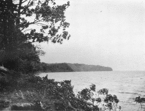
The shores of Mille Lac, one of the most beautiful sheets of water in Minnesota, abound in traces of the ancient settlements which stood generations or centuries ago. Near several of the sites are groups of a hundred or more burial mounds, all of which may be attributed to the Siouan tribes. One village, the site of which is marked by a large number of mounds, stood on the shore of the bay in the northwestern part of the lake, shown in the photograph reproduced in plate 20, a.
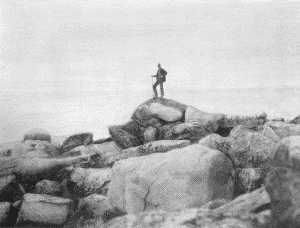
The sacred or mysterious island, known as such to the Sioux and later to the Ojibway, is in the southern part of the lake, several miles from the south shore. It is a remarkable spot, one to be looked upon by the Indian as a place of mystery. So small that often it is not visible from the shore, it consists of a great quantity of blocks of granitic formation which are piled to a height of 20 feet or more upon a ledge which comes to within a foot or less of the surface of the lake. The island is about 250 feet in length from east to west, the width from north to south being about one-half the length. Some of the great blocks are 10 or 12 feet in length, 4 or 5 feet in thickness and width, and would weigh many tons. The ledge extends for a distance of about 150 feet to the north and east of the island, covered by a foot or more of water. There is no soil on the island, no vegetation, and its only occupants are numbers of gulls. A photograph of this most interesting spot, made by the writer May 20, 1900, is reproduced as plate 20, b.
BUREAU OF AMERICAN ETHNOLOGY BULLETIN 77 PLATE 20
a. Northwest shore of Mille Lac, 1900. Site of an ancient Sioux settlement
b. The Sacred Island in the southern part of Mille Lac. May, 1900
BUREAU OF AMERICAN ETHNOLOGY BULLETIN 77 PLATE 21
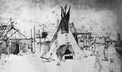
"KAPOSIA, JUNE 19TH, 1851" F. B. Mayer
According to the stories of the old Ojibway who were still living on the shore of Mille Lac during the spring of 1900, the Mdewakanton were driven from that region about the middle of the eighteenth century, and moving southward settled along the banks of the Mississippi. Descendants of these were occupying well-known villages on the Mississippi and Minnesota during the summer of 1823, when Major Long and his party ascended the rivers from Prairie du Chien.
Before leaving Prairie du Chien to discover the course of the Minnesota, or St. Peters, as it was then designated, the members of the expedition were divided into two groups, one to go overland to the mouth of the St. Peters, the other to convey the supplies by boat to that point. Both parties visited the principal villages on the way. First following the route of those who went overland, on June 26, 1823, they encountered a village of five lodges, evidently on the Iowa River, in the present Winneshiek County, Iowa. Two days later, June 28, they arrived at the more important village of Wapasha, in the present Wabasha County, Minnesota, and as told in the narrative: "Whatever might be the reveries in which the party were indulging, they were soon recalled to the dull realities of travelling, by the howling and barking of a band of dogs, that announced their approach to an Indian village consisting of twenty fixed lodges and cabins. It is controlled by Wa-pa-sha, an Indian chief of considerable distinction. In his language, (Dacota,) his name signifies the red leaf. A number of young men fantastically decorated with many and variously coloured feathers, and their faces as oddly painted, advanced to greet the party. One of them, the son of the chief, was remarkable for the gaudiness and display of his dress, which from its showy appearance imparted to his character foppishness.... The chief is about fifty years of age, but appears older.... His disposition to the Americans has generally been a friendly one." (Keating, (1), I, pp. 249-250.) Hennepin's reception by the ancestors of the same people, in their ancient village near Mille Lac, about a century and a half earlier, may have been quite similar to this accorded the members of the Long expedition in 1823.
On the evening of June 30 the party going by land arrived "at an Indian village, which is under the direction of Shakea, (the man that paints himself red;) the village has retained the appellation of Redwing, (aile rouge,) by which the chief was formerly distinguished." This was on the site of the present Red Wing, Goodhue County, Minnesota. There the party remained overnight, and on the following morning, July 1, 1823, the boat bearing the supplies belonging to the expedition, on its way from Prairie du Chien to Fort St. Anthony, reached the village, and "The whole party being again united, the chief invited them to his lodge, with a view to have a formal conversation with them.... As a compliment to the party, the United States' flag was hoisted over his cabin, and a deputation of some of his warriors waited at our encampment to invite us to his lodge. We were received in due ceremony; the chief and his son, Tatunkamane, (the walking buffalo,) were seated next to the entrance. We took our stations near them, on the same bed-frame, while his warriors seated themselves on the frame opposite to us." This was followed by handshaking, and the smoking of the pipe of peace. (Op. cit., pp. 251-252.) The two parties again separated and those passing overland arrived at the fort the following evening.
The boat party, ascending the Mississippi, arrived at "Wapasha's village" on June 29, soon after the departure of the others who were going overland. They left Redwing early in the afternoon of July 1, and on the following day passed the St. Croix. Continuing, they "passed an Indian village consisting of ten or twelve huts, situated at a handsome turn on the river, about ten miles below the mouth of the St. Peter; the village is generally known by the name of the Petit Corbeau, or Little Raven, which was the appellation of the father and grandfather of the present chief.... As the village was abandoned for the season, we proceeded without stopping. The houses which we saw here were differently constructed from those which we had previously observed. They are formed by upright flattened posts, implanted in the ground, without any interval except here and there some small loopholes for defence; these posts support the roof, which presents a surface of bark. Before and behind each hut, there is a scaffold used for the purpose of drying maize, pumpkins, &c." Late in the same day they arrived at the fort. (Keating, (1), I, pp. 288-289.) Whether the method of constructing lodges by forming the walls of upright posts or logs was of native conception or was derived from the French is now difficult to determine. In referring to the customs prevailing in the Mississippi Valley, particularly the French portions, about the year 1810, Brackenridge said: "In building their houses, the logs, instead of being laid horizontally, as ours, are placed in a perpendicular position, the interstices closed with earth or stone, as with us." (Brackenridge, (1), p. 119.) The old courthouse at St. Louis was built after this method. Again, among some tribes along the eastern slopes of the Rocky Mountains, as will be told on another page, were to have been found small, well-protected lodges formed of upright poles, and in this instance there is no reason to suspect European influence. Therefore it is not possible to say definitely whether the structures standing on the banks of the Mississippi during the summer of 1823 were of a primitive, native form, or if they represented the influence of the early French who had penetrated the region many years before.
Just three years before the Long expedition passed up the Mississippi and prepared the preceding descriptions of the Sioux settlements Schoolcraft went down the river, and in his journal are to be found brief references to the same villages. To quote from the journal, August 2, 1820: "Four miles below Carver's cave, we landed at the village of Le Petit Corbeau, or the Little Raven. Here is a Sioux band of twelve lodges, and consisting of about two hundred souls, who plant corn upon the adjoining plain, and cultivate the cucumber, and pumpkin. They sallied from their lodges on seeing us approach, and gathering upon the bank of the river fired a kind of feu-de-joie, and manifested the utmost satisfaction on our landing.... We were conducted into his cabin which is spacious, being about sixty feet in length by thirty in width—built in a permanent manner of logs, and covered with bark." (Schoolcraft, (2), pp. 317-318.) The following day at noon the party arrived "at the Sioux village of Talangamane, or the Red wing, which is handsomely situated on the west banks of the river, six miles above Lake Pepin. It consists of four large, and several small lodges, built of logs in the manner of the little Raven's village. Talangamane is now considered the first chief of his nation.... Very few of his people were at home, being engaged in hunting or fishing. We observed several fine corn fields near the village, but they subsist chiefly by taking sturgeon in the neighbouring lake, and by hunting the deer. The buffalo is also occasionally killed, but they are obliged to go two days journey west of the Mississippi, before this animal is found in plenty. We observed several buffalo skins which were undergoing the Indian process of tanning." (Op. cit., p. 323.) The third settlement was reached during the afternoon of August 4, 1820, at which time, to quote from the journal, "we made a short halt at the Sioux village of Wabashaw, which is eligibly situated on the west bank of the Mississippi, sixty miles below Lake Pepin. It consists of four large lodges, with a population of, probably, sixty souls. A present of tobacco and whiskey was given, and we again embarked at twenty minutes before five o'clock." (Op, cit., p. 334.) The question now arises, Were the various structures seen by Schoolcraft, those "built in a permanent manner of logs," constructed of "upright flattened posts," as mentioned in the Long narrative? If so, it is evident similar habitations were reared by the Foxes and were encountered by Schoolcraft at the Fox village standing on the left bank of the Mississippi, below the mouth of the Wisconsin, August 6, 1820. However, the statements are rather vague, and the various dwellings may have been quite similar to the bark houses more clearly described in later narratives. But it is beyond question that some of the structures were strongly built, and Long on July 16, 1817, wrote: "Passed a Sioux village on our right containing fourteen cabins. The name of the chief is the Petit Corbeau, or Little Raven.... One of their cabins is furnished with loop holes, and is situated so near the water that the opposite side of the river is within musket-shot range from the building.... The cabins are a kind of stockade buildings, and of a better appearance than any Indian dwellings I have before met with." (Long, (1), p. 31.)
One of the most interesting accounts of the villages just mentioned is contained in the journal of a traveler who visited them in 1849, the year the Territory of Minnesota was created. On May 16 of that year he "passed Wapasha's Prairie ... a beautiful prairie in Minnesota, about nine miles long and three miles wide, occupied by the chief Wapasha (or Red-Leaf) and his band of Sioux, whose bark lodges are seen at the upper end of the prairie." (Seymour, (1), p. 75.) And later in the day, after leaving Lake Pepin, "an Indian village, called Red Wing, inhabited by a tribe of Sioux is seen on the Minnesota shore. It appears to contain about one dozen bark lodges, and half as many conical lodges, covered with buffalo skins; also, a log or frame house, occupied by a missionary. Indian children were seen running, in frolicsome mood, over the green prairie, and Indian females were paddling their canoes along the shore. This village is near the mouth of Cannon River." On the following day, May 17, 1849, Seymour passed the village of Kaposia, occupied by the chief Little Crow, or Little Raven. It stood on the west bank of the river about 5 miles below the then small town of St. Paul. The Indian village at that time consisted of about 40 lodges, having a population of some 300. A few days later he went to the village, and regarding the visit wrote: "During the time I visited them, the Indians were living in skin lodges, such as they use during the winter, and when traveling. These are formed of long, slender poles, stuck in the ground, in a circle of about eight feet in diameter, and united at the top, and covered with the raw hide of the buffalo, having the hair scraped off. They are in the form of a cone, and can be distinguished from those of the Winnebagos and other Indians as far as they can be seen. During the summer they live in bark houses, which are more spacious, and when seen from a distance, resemble, in form and appearance, the log cabins of the whites. When passing in sight of the village, a few days afterward, I noticed that they had removed their skin lodges, and erected their bark houses. The population of this village, as I before remarked, is from 250 to 300 souls." He entered one of the small skin-covered lodges. "An iron kettle, suspended in the center, over a fire, forms the principal cooking utensil. Blankets spread around on the ground, were used as seats and beds." (Op. cit., pp. 137-138.) A cemetery, with its scaffold burials, stood on the bluffs in the rear of the village. There is reason to believe these were the first skin-covered tipis encountered by Seymour while ascending the Mississippi.
BUREAU OF AMERICAN ETHNOLOGY BULLETIN 77 PLATE 22
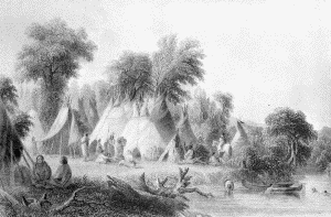
a. "Dakotah Village." Seth Eastman
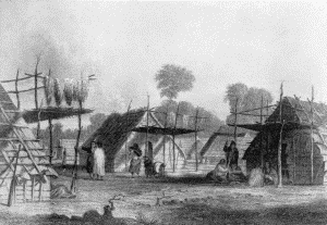
b. "Dakotah Encampment." Seth Eastman
BUREAU OF AMERICAN ETHNOLOGY BULLETIN 77 PLATE 23
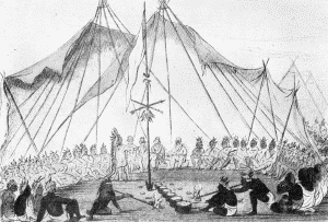
a. Council at the mouth of the Teton. George Catlin
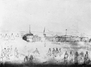
b. Page of Kurz's Sketchbook, showing Fort Pierre and the Indian encampment, July 4, 1851
It will be noticed that in the preceding description of Kaposia no mention is made of log structures, such as were alluded to by Long and Schoolcraft. Only the typical bark house and the conical skin-covered tipi were seen by Seymour. Fortunately a most valuable and interesting picture of the village, as it appeared on June 19, 1851, is preserved and is now reproduced in plate 21. Both forms of habitations are shown, and in the distance, on the left, are indicated the scaffold burials standing on the bluffs in the rear of the settlement. On the extreme right is the prow of a canoe, evidently on the immediate bank of the Mississippi. Having this remarkable sketch, it is gratifying to find a brief description of the two forms of lodges, and also to know that the notes may have referred to Kaposia in particular. It tells that "the lodges are from eight to fifteen feet in diameter, about ten to fifteen feet high and made of buffalo-skins tanned. Elk skins are used for this purpose also. The summer house is built of wood, or perches set upright, twenty or thirty feet long, by fifteen or twenty wide. The perches are set in the ground about one foot, and are about six feet out of the ground. Over this is put a roof of elm bark. They are very comfortable for summer use. The lodge of skin lasts three or four years; the lodge of wood seven or eight years." (Prescott, (1), p. 67.)
The bark houses, which resembled "the log cabins of the whites," were shown by Capt. Eastman in one of his paintings. It was used as an illustration by Schoolcraft, and is here reproduced as plate 22, a. It is less interesting than the sketch of Kaposia, but in many respects the two are quite similar.
Several bark houses of the form just mentioned stood on the shore of Mille Lac, forming part of the Ojibway village visited in 1900, and similar to these were the "winter habitations," occasionally erected by the Menominee, as mentioned and figured by Hoffman as plate xviii in his work on that tribe. (Hoffman, (1), p. 255.) It is rather curious that these should be described as "winter habitations" among that Algonquian tribe, and as being occupied during the summer by the Siouan people. As a matter of fact this strong distinction may not have existed. The use of this type of house by the Foxes has already been mentioned. Whether these may be regarded as representing a purely aboriginal form of structure is not easily determined, but they will at once recall the unit of the long communal dwellings of the Iroquois. The slanting roof, the flat front and back, and the upright walls, all covered with large sheets of bark, were the same.
Again returning to the narrative of the Long expedition. Early in July, 1823, the party having rested at the mouth of the Minnesota, or St. Peters River, began ascending that stream. Having advanced a short distance they arrived at the village of Taoapa, better known as "Shakopee's Village," from the name of the chief of this band of the Mdewakanton. It stood in the present Scott County, Minnesota, and in the summer of 1823 "consisted of fifteen large bark lodges, in good order; they were arranged along the river. Some of them were large enough to hold from thirty to fifty persons, accommodated as the Indians usually are in their lodges. The ground near it is neatly laid out, and some fine corn-fields were observed in the vicinity. There were scaffolds annexed to the houses, for the purpose of drying maize, etc.; upon these we were told that the Indians sleep during very hot nights." Near the village were seen various scaffold burials, while "In the midst of the corn-fields a dog was suspended, his head decorated with feathers, and with horse-hair stained red; it was probably a sacrifice for the protection of the corn-fields during the absence of the Indians." Six miles above the village was Little Prairie. (Keating, (1), pp. 329-330.) Quite likely the structures at this village were similar to those described above, which resembled in outline the log cabins of the white settlers.
Wahpeton.
The Wahpeton, "dwellers among leaves," constitute one of the seven great divisions of the Dakota, and to quote from the Handbook: "Historic and linguistic evidence proves the affinity of this tribe with the Sisseton, Wahpekute, and Mdewakanton. Hennepin (1680) mentions them as living in the vicinity of Mille Lac, Minn., near the Mdewakanton, Sisseton, and Teton. On his map they are placed a little to the N. E. of the lake." While living in the seclusion of the vast forests which surrounded the great lakes of central Minnesota, the villages of the Wahpeton were probably formed of groups of bark or mat covered structures so typical of the region at a later day. Gradually they left the timbered regions, and about the first years of the last century were living near the mouth of the Minnesota River. Thence they appear to have moved up the stream, and during the summer of 1823 were encountered by the Long expedition in the vicinity of Big Stone Lake, in the present Lac qui Parle County, Minnesota. The account of the meeting with the Indians on the prairie, and later of their visit to the village, by the members of the expedition, is most interesting. On July 21, 1823, "While traveling over the prairie which borders upon this part of the St. Peter, that connects Lake qui Parle with Big Stone Lake, our attention was aroused by the sight of what appeared to be buffaloes chased across the prairie. They, however, soon proved to be Indians; their number, at first limited to two, gradually increased to near one hundred; they were seen rising from every part of the prairie, and after those in advance had reconnoitered us, and made signals that we were friends, by discharging their guns, they all came running towards us, and in a few minutes we found ourselves surrounded by a numerous band.... Some of them were mounted on horseback, and were constantly drumming upon the sides of their horses with their heels, being destitute both of whip and spur. Many of them came and shook hands with us, while the rest were riding all round us in different directions. They belonged, as we were told, to the Wahkpatoan, [Wahpeton] one of the tribes of the Dacotas.... As we rode towards their lodges, we were met by a large party of squaws and children, who formed a very motly group.... The village, to which they directed us, consisted of thirty skin lodges, situated on a fine meadow on the bank of the lake. Their permanent residence, or at least that which they have occupied as such for the last five years, is on a rocky island, (Big Island), in the lake, nearly opposite to, and within a quarter of a mile of, their present encampment. Upon the island they cultivate their cornfields, secure against the aggressions of their enemies. They had been lately engaged in hunting buffalo, apparently with much success. The principal man led us to his lodge, wherein a number of the influential men were admitted, the women being excluded; but we observed that they, with the children, went about the lodge, peeping through all the crevices, and not unfrequently raising the skins to observe our motion. They soon brought in a couple of large wooden dishes, filled with pounded buffalo meat boiled, and covered with the marrow of the same animal; of this we partook with great delight." This was followed by another feast, in a near-by tent, and still a third where a dog had been killed and prepared, "which is considered not only as the greatest delicacy, but also as a sacred animal, of which they eat only on great occasions." The party did not remain long at the village, but continued on up the lake shore, and soon encountered on a bluff "two Indian lodges, in one of which was Tatanka Wechacheta, (the buffalo man,) an Indian who claims the command of the Wahkpatoans." Later in the day the party returned to these lodges, where "the chief, and his principal men, were in waiting. We entered the skin lodge, and were seated on fine buffalo robes, spread all round; on the fire, which was in the centre of the lodge, two large iron kettles, filled with choicest pieces of buffalo, were placed.... Our hosts were gratified and flattered at the quantity which we ate; the residue of the feast was sent to our soldiers. In this, and every other instance where we have been invited to a feast by Indians, we observed that they never eat with their guests." (Keating, (1), I, pp. 367-373.)
The village of skin-covered tipis standing on the shore of the lake, as seen by members of the expedition on that July day nearly a century ago, must have resembled the painting later made by Capt. Eastman, which is reproduced in plate 22, b, taken from Schoolcraft. In the painting the tipis are undoubtedly too closely placed, but otherwise they are quite accurately shown. This illustration as used in Schoolcraft bears the legend "Dakotah Encampment."
Yanktonai.
Like other divisions of the Dakota, the Yanktonai formerly lived in the thickly timbered region surrounding the headwaters of the Mississippi, in the central portion of the present State of Minnesota, and, like them, moved southward and westward until they reached the plains and the habitat of the buffalo. Although in their earlier home they undoubtedly reared the mat-covered structures, nevertheless when they reached the open country they constructed the conical skin lodge.
During the latter part of July, 1823, the Long expedition reached a village of this tribe then standing in the vicinity of Lake Traverse, in the present Traverse County, Minnesota. In the narrative of the expedition very little is said regarding the appearance of the encampment, which may not have offered any peculiar features, but much was said concerning the dress and ways of the inhabitants. In part the narrative states: "The principal interest which we experienced in the neighbourhood of Lake Traverse, was from an acquaintance with Wanotan, (the Charger,) the most distinguished chief of the Yanktoanan tribe, which, as we were informed, is subdivided into six bands. He is one of the greatest men of the Dacota nation, and although but twenty-eight years of age, he has already acquired great renown as a warrior." As the party neared the establishment of the Columbia Fur Company, on the border of the lake, "a salute was fired from a number of Indian tents which were pitched in the vicinity, from the largest of which the American colours were flying. And as soon as we had dismounted from our horses, we received an invitation to a feast which Wanotan had prepared for us." Three dogs had been killed and prepared for the great occasion. "We repaired to a sort of pavilion which they had erected by the union of several large skin lodges. Fine Buffalo robes were spread all around, and the air was perfumed by the odour of sweet scenting grass which had been burned in it. On entering the lodge we saw the chief seated near the further end of it, and one of his principal men pointed out to us the place which was destined for our accommodation; it was at the upper end of the lodge." (Keating, (1), I, pp. 429-432.)
Arranging the skin covers of several large tipis in such a way as to form a single shelter, to serve as a ceremonial "lodge," was the custom of many tribes, and other instances will be mentioned. But another and more elaborate form of structure was used by the tribes just mentioned. In 1858, when describing certain customs of the people then living along the course of the Minnesota and in the vicinity of Lake Traverse, Riggs referred to the sacred dance and said: "Among the Dakotas a most remarkable society exists which is called Wakan wachepe, or Sacred Dance, of which the medicine sack is the badge. It may be regarded as the depository and guardian of whatever they esteem as wakan, or sacred." He then related the contents of the bag and the meaning of the ceremony, and continues: "A large skin lodge is usually occupied as the center of operations, the door of which is made wide by throwing up the corners. From this, on each hand, extends a kind of railing, some thirty or forty feet, on which skins are thrown. The entrance is at the farther end. All around the inside of this sanctum sanctorum and along the extended sides sit those who are called to the dance. Beyond this and near the place of entrance is a fire, with great kettles hanging over it, which are filled with dried buffalo meat or other food; and near by lay several packs or bags of the same, which are consecrated to the feast. The whole village are gathered around and are looking over or peeping through the holes in the barricades." Much was then told about the strange and curious ceremonies enacted within the lodge. (Riggs, (1), pp. 505-506.)
Leaving the encampment in the vicinity of the post of the Columbia Fur Company, the Long expedition moved northward, and when just beyond Lake Traverse, while traversing the prairies on July 27, 1823, "passed a party of squaws engaged in conveying to their camp some slices of fresh meat to jerk; their fellow labourers were dogs. Each of the dogs had the ends of two poles crossed and fastened over the shoulders, with a piece of hide underneath to prevent chafing. The other extremities dragged on the ground. This sort of vehicle was secured to the animal by a string passing round the breast, and another under the abdomen; transverse sticks, the ends of which were fastened in the poles, kept these at a proper distance, and supported the meat. This seems to be the only mode of harnessing dogs, practised among the Sioux; we believe, they never use them in teams, as is customary with the traders." (Keating, (1), II, pp. 9-10.)
The expedition soon arrived at Pembina, near the international boundary, where it would appear they found the two characteristic forms of native habitations in use by the Indians. A drawing was at that time made by Seymour and used as an illustration in the narrative, showing the "two different kind of lodges used by the northwest Indians," the first being the skin lodge of the prairie tribes, and "of this nature are all the lodges used by the Dacotas;" the second were the bark-covered structures of the Ojibway, "who for the most part live to the north-east of the buffalo regions." To this latter class must have belonged the habitations of the Siouan tribes before they were forced from their early homes among the forests and lakes to the eastward.
When referring to the two characteristic forms of habitations it will be of interest to quote from the writings of one who traversed the country more than a century and a half ago, when all was in its primitive condition, but, like many writers of that period, he failed to give details which at the present time would prove of the greatest value. He wrote: "The Indians, in general, pay a greater attention to their dress and to the ornaments with which they decorate their persons, than to the accommodation of their huts or tents. They construct the latter in the following simple and expeditious manner.
"Being provided with poles of a proper length, they fasten two of them across, near their ends, with bands made of bark. Having done this, they raise them up, and extend the bottom of each as wide as they purpose to make the area of the tent: they then erect others of an equal height, and fix them so as to support the two principal ones. On the whole they lay skins of the elk or deer, sewed together, in quantity sufficient to cover the poles, and by lapping over to form the door. A great number of skins are sometimes required for this purpose, as some of their tents are very capacious. That of the chief warrior of the Naudowessies was at least forty feet in circumference, and very commodious.
"They observe no regularity in fixing their tents when they encamp, but place them just as it suits their conveniency.
"The huts also, which those who use no tents erect when they travel, for very few tribes have fixed abodes or regular towns or villages, are equally simple, and almost as soon constructed.
"They fix small pliable poles in the ground, by bending them till they meet at the top and form a semi-circle, then lash them together. These they cover with mats made of rushes platted, or with birch bark, which they carry with them in their canoes for this purpose.
"These cabins have neither chimnies nor windows; there is only a small aperture left in the middle of the roofs through which the smoke is discharged, but as this is obliged to be stopped up when it rains or snows violently, the smoke then proves exceedingly troublesome.
"They lie on skins, generally those of the bear, which are placed in rows on the ground; and if the floor is not large enough to contain beds sufficient for the accommodation of the whole family, a frame is erected about four or five feet from the ground, in which the younger part of it sleep." (Carver, (1), pp. 152-154.) Though lacking much in detail, nevertheless the preceding notes are of historical interest and value, describing as they do the primitive habitations which were reared and occupied by the native tribes living in the upper Mississippi Valley about the middle of the eighteenth century. Skins of the elk and deer were evidently used as coverings for the conical tipi, which seems to prove the lack of a sufficient number of buffalo skins to serve the purpose, although farther west, beyond the timbered country, where buffalo were more easily obtained, their skins were made use of and covered the shelters of tribes by whom they were hunted.
Yankton.
When the expedition under the leadership of General Atkinson ascended the Missouri, during the summer of 1825, he wrote regarding the Yankton: "The Yanctons are a band of the Sioux, and rove in the plains north of the Missouri, from near the Great Bend, down as far as the Sioux river. They do not cultivate, but live by the chase alone, subsisting principally upon buffalo. They cover themselves with leather tents, or lodges, which they move about from place to place, as the buffalo may chance to range. They are pretty well supplied with fusees, and with horses, and a few mules. They are estimated at 3,000 souls, of which 600 are warriors. They are comfortably habited in frocks, or shirts of dressed skins, and leggings, reaching to the waist, of the same; they use besides, robes of buffalo skins, which are frequently beautifully wrought with porcupine quills, or painted tastefully; are friendly to the whites, but make war upon almost all other tribes, except those of their own nation. Their trading ground is on the river Jaques." (Atkinson, (1), pp. 8-9.) On June 17 the party arrived at Fort Lookout, a post of the American Fur Company, and four days later, "on the 21st, the Tetons, Yanctons, and Yanctonies, three distinct bands of the Sioux Nation, having arrived, a council was opened, and, on the 22d, a treaty concluded with them." This great gathering of the tribes, with their numerous skin-covered tipis, would have presented a sight similar to that witnessed and described by Catlin just seven years later, in the vicinity of Fort Pierre.
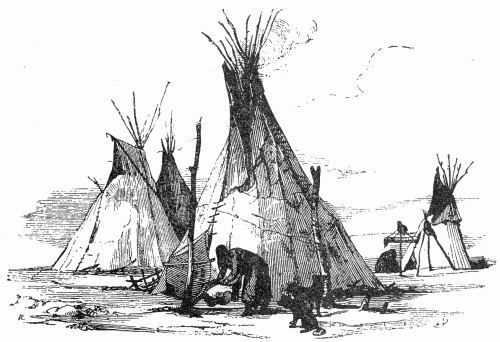
An excellent description of the skin-covered tipi of the Sioux, but of the structures of the Yankton in particular, is contained in Maximilian's narrative. Writing on May 25, 1833, he said the "Sioux Agency, or, as it is now usually called, Fort Lookout, is a square, of about sixty paces, surrounded by pickets, twenty or thirty feet high, made of squared trunks of trees placed close to each other, within which the dwellings are built close to the palisades.... About ten leather tents or huts of the Sioux, of the branch of the Yanktons or Yanktoans, were set up near the fort.... All these Dacotas of the Missouri, as well as most of those of the Mississippi, are only hunters, and, in their excursions, always live in portable leather tents.... The tents of the Sioux are high pointed cones, made of strong poles, covered with buffalo skins, closely sewed together. These skins are scraped on both sides, so that they become as transparent as parchment, and give free admission to the light. At the top, where the poles meet, or cross each other, there is an opening, to let out the smoke, which they endeavor to close by a piece of the skin covering of the tent, fixed to a separate pole standing upright, and fastened to the upper part of the covering on the side from which the wind blows. The door is a slit, in the front of the tent, which is generally closed by another piece of buffalo hide, stretched upon a frame. A small fire is kept up in the centre of the tent. Poles are stuck in the ground, near the tent, and utensils of various kinds are suspended from them. There are, likewise, stages, on which to hang the newly-tanned hides; others, with gaily-painted parchment pouches and bags, on some of which they hang their bows, arrows, quivers, leather shields, spears, and war clubs.
"We paid a visit to Wahktageli in his tent, and had some difficulty in creeping into the narrow, low entrance, after pulling aside the skin that covered it. The inside of this tent was light, and it was about ten paces in diameter. Buffalo skins were spread on the ground, upon which we sat down. Between us and the side of the tent were a variety of articles, such as pouches, boxes, saddles, arms, &c. A relation of the chief was employed in making arrows, which were finished very neatly, and with great care. Wahktageli immediately, with much gravity, handed the tobacco-pipe round, and seemed to inhale the precious smoke with great delight.... The conversation was carried on by Cephier, the interpreter kept by the Agency, who accompanied us on this visit.... The owner of a neighbouring tent had killed a large elk, the skin of which the women were then busily employed in dressing. They had stretched it out, by means of leather straps, on the ground near the tent, and the women were scraping off the particles of flesh and fat with a very well-contrived instrument. It is made of bone, sharpened at one end, and furnished with little teeth like a saw, and, at the other end, a strap, which is fastened round the wrist." (Maximilian, (1), pp. 148-152.) A drawing by Bodmer, reproduced by Maximilian on page 151 of the work cited, is here shown as figure 2. It represents a small group of tipis, of the type mentioned in the narrative, and on the right, in the rear, is a tripod with what appears to be a shield suspended from it. The bone implement mentioned as being used by the women to remove particles of flesh from the skin of the recently killed elk belonged to a well-known type which was extensively used throughout the region. It was formed of the large bones of the leg of the buffalo, elk, or moose. Many old examples are preserved in the National Museum, Washington.
Fig. 2.—Tipis.
When dealing with the agents of the Government the Yankton would gather on the plains around Fort Pierre. Just 20 years after Maximilian's visit to the upper Missouri a small party passed down the river, and on October 18, 1853, entered in their journal: "We reached Fort Pierre about 12 o'clock m.... Two days before our arrival at this place, the main body of the Yankton Sioux, in number some twenty-five hundred, had left for the buffalo country. They have been here to receive their presents from the government. Two more bands are expected in a few days." (Saxton, (1), p. 267.) And some days later, while continuing down the Missouri: "The prairies are burning in every direction, and the smoke is almost stifling."
Teton.
The Teton, moving westward from their early habitat to the east and north of the Minnesota, were encountered on the banks of the Missouri by Captains Lewis and Clark when they ascended the river, during the early autumn of 1804. On September 26 of that year the expedition reached the mouth of Teton River (the present Bad River), which enters the Missouri from the west at Pierre, Stanley County, South Dakota. Here stood the great village of the Teton, concerning which Sergeant Gass gave a very interesting account in his journal: "We remained here all day. Capt. Lewis, myself and some of the men, went over to the Indian camp. Their lodges are about eighty in number, and contain about ten persons each; the greater part women and children. The women were employed in dressing buffaloe skins, for clothing for themselves and for covering their lodges. They are the most friendly people I ever saw; but will pilfer if they have an opportunity. They are also very dirty: the water they make use of, is carried in the paunches of the animals they kill, just as they are emptied, without being cleaned.... About 3 o'clock we went aboard the boat accompanied with the old chief and his little son. In the evening captain Clarke and some of the men went over, and the Indians made preparations for a dance. At dark it commenced. Captain Lewis, myself and some of our party went up to see them perform. Their band of music, or orchestra, was composed of about twelve persons beating on a buffalo hide, and shaking small bags that made a rattling noise. They had a large fire in the centre of their camp; on one side the women, about 80 in number, formed a solid column round the fire, with sticks in their hands, and the scalps of the Mahas they had killed, tied on them. They kept moving, or jumping round the fire, rising and falling on both feet at once; keeping a continual noise, singing and yelling. In this manner they continued till 1 o'clock at night, when we returned to the boat with two of the chiefs." (Gass, (1), pp. 45-46.)
In the journal of the expedition is a very full account of the events which transpired during the two days spent at the Teton camp, but only part will now be quoted, sufficient to describe the place of meeting: "Captain Lewis went on shore and remained several hours, and observing that their disposition was friendly we resolved to remain during the night to a dance, which they were preparing for us. Captains Lewis and Clark, who went on shore one after the other, were met on landing by ten well dressed young men, who took them up in a robe highly decorated and carried them to a large council house, where they were placed on a dressed buffaloe skin by the side of the grand chief. The hall or council-room was in the shape of three quarters of a circle, covered at the top and sides with skins well dressed and sewed together. Under this shelter sat about seventy men, forming a circle round the chief, before whom were placed a Spanish flag and the one we had given them yesterday. This left a vacant circle of about six feet diameter, in which the pipe of peace was raised on two forked sticks, about six or eight inches from the ground, and under it the down of the swan was scattered: a large fire, in which they were cooking provisions, stood near, and in the centre about four hundred pounds of excellent buffaloe meat as a present for us." Then followed several addresses by the chiefs; offerings of dog meat to the flag "by way of sacrifice," and the smoking of the pipe of peace. (Lewis and Clark, (1), I, pp. 84-86.) The entire ceremony proved of the greatest interest. Then followed an account of the habitations standing in the village: "Their lodges are very neatly constructed, in the same form as those of the Yanktons; they consist of about one hundred cabins, made of white buffaloe hide dressed, with a larger one in the centre for holding councils and dances. They are built round with poles about fifteen or twenty feet high, covered with white skins; these lodges may be taken to pieces, packed up, and carried with the nation wherever they go, by dogs which bear great burdens. The women are chiefly employed in dressing buffaloe skins: they seem perfectly well disposed, but are addicted to stealing any thing which they can take without being observed." (Op. cit., pp. 88-89.)
During the year 1832 George Catlin remained for some time at and near the mouth of the Teton, where a few years before had been erected a station of the American Fur Company, which was soon given the name Fort Pierre. "The country about this Fort is almost entirely prairie, producing along the banks of the river and streams only, slight skirtings of timber.... On my way up the river I made a painting of this lovely spot, taken from the summit of the bluffs, a mile or two distant, showing an encampment of Sioux, of six hundred tents of skin lodges, around the Fort, where they had concentrated to make their spring trade; exchanging their furs and peltries for articles and luxuries of civilized manufactures." (Catlin, (1), I, p. 209.) And he continued (p. 211): "I mentioned that this is the nucleus or place of concentration of the numerous tribe of the Sioux, who often congregate here in great masses to make their trades with the American Fur Company; and that on my way up the river, some months since, I found here encamped, six hundred families of Sioux, living in tents covered with buffalo hides. Amongst these there were twenty or more of the different bands, each one with their chief at their head, over whom was a superior chief and leader, a middle-aged man, of middling stature, with a noble countenance.... The name of this chief is Ha-won-je-tah (the one horn) of the Mee-ne-cow-e-gee band, who has risen rapidly to the highest honours in the tribe."
About this time a "grand feast" was prepared by the Indians in honor of the Indian agent and the several Americans who were then at Fort Pierre, including Catlin. A sketch of the gathering is shown in plate 23, a, after the illustration in Catlin's narrative, but it may be of interest to know that the original painting is now in the National Museum, Washington. Describing this scene, Catlin wrote:
"The two chiefs, Ha-wan-je-tah and Tchan-dee ... brought their two tents together, forming the two into a semi-circle, enclosing a space sufficiently large to accommodate 150 men; and sat down with that number of the principal chiefs and warriors of the Sioux nation." The several Americans were "placed on elevated seats in the centre of the crescent; while the rest of the company all sat upon the ground, and mostly cross-legged, preparatory to the feast being dealt out. In the centre of the semi-circle was erected a flag-staff, on which was waving a white flag, and to which also was tied the calumet, both expressive of their friendly feelings towards us. Near the foot of the flag-staff were placed in a row on the ground, six or eight kettles, with iron covers on them, shutting them tight, in which were prepared the viands for our voluptuous feast. Near the kettles, and on the ground also, bottomside upwards, were a number of wooden bowls, in which the meat was to be served out. And in front, two or three men, who were there placed as waiters, to light the pipes for smoking, and also to deal out the food." (Op. cit., p. 228.) The account of the ceremony which soon followed proves the gathering to have been one of much interest, and to the Indians one of great moment. The arrangement of the two large tipis so as to form a single shelter recalls the site of the gathering near the shore of Lake Traverse only a few years before. It is to be regretted that Catlin did not leave a more detailed description of the appearance of the great encampment as it was at the time of his visit, but he devoted much of his time to painting portraits of the Indians, of which he prepared a large number.
Although Catlin found representatives of many bands of Sioux gathered about on the plain surrounding Fort Pierre, nevertheless the comparatively permanent village of the Teton was near the mouth of the stream of that name. Maximilian, who ascended the Missouri during the spring of 1833, arrived at Fort Pierre late in May, and in his journal said: "The Sioux, who live on Teton River, near Fort Pierre, are mostly of the branch of the Tetons; though there are some Yanktons here." (Maximilian, (1), p. 150.) He elsewhere mentioned that "the tents are generally composed of fourteen skins," therefore consider the great number of buffalo required to furnish coverings for the lodges mentioned by Catlin. Maximilian wrote on May 30, 1833, near Fort Pierre: "Round an isolated tree in the prairie I observed a circle of holes in the ground, in which thick poles had stood. A number of buffalo skulls were piled up there; and we were told that this was a medicine, or charm, contrived by the Indians in order to entice the herds of buffaloes. Everywhere in the plain we saw circles of clods of earth, with a small circular ditch, where the tents of many Indians had stood." (Op. cit., p. 157.) These were evidently the remains of the encampment seen by Catlin the preceding year.
A sketch of Fort Pierre as it appeared July 4, 1851, is given in plate 23, b. This was the work of the young Swiss artist, Friedrich Kurz, and is now reproduced for the first time. The small groups of Indians, the tipis standing near the fort, and the rolling prairie in the distance are all graphically shown.
The several divisions of the Teton performed the sun dance, at which time a large ceremonial lodge would be erected, which stood alone in the camp circle, formed of the numerous skin tipis. The lodge as reared at different times and by the various tribes varied in form and method of construction, but it seems to have been the custom of all the tribes to abandon the structure at the termination of the ceremonies. It was regarded as a sacred place and one not to be destroyed by man. Large structures of this sort were often encountered by parties traversing the plains and adjacent regions, and one, probably erected by a tribe of the Teton, was discovered by the Raynolds party, July 16, 1859, in the extreme eastern part of the present Crook County, Wyoming. In the journal of the expedition it was written on that day, "We have not yet met any Indians, nor any indications of their recent presence. The site of our camp is, however, marked by the remains of an immense Indian lodge, the frame of which consists of large poles, over thirty feet in length. Close by is also a high post, around which a perfect circle of buffalo skulls has been arranged." (Raynolds, (1), p. 31.) This may have been used during the preceding year, at which time the skin tipis of the people enacting the sacred ceremonies were pitched in the form of a circle with the great lodge standing in the center. But with the completion of the annual dance the participants removed, with their skin tipis, to other localities, allowing the sacred structure to be destroyed by the elements.
OGLALA.
Of the early history of this, the principal division of the Teton, nothing is known. During the first years of the last century they were discovered by Lewis and Clark on the banks of the upper Missouri, south of the Cheyenne River, in the present Stanley County, South Dakota. They hunted and roamed over a wide region, and by the middle of the century occupied the country between the Forks of the Platte and beyond to the Black Hills. While living on the banks of the Missouri their villages undoubtedly resembled the skin-covered tipi settlements of the other kindred tribes, and later, when they had pushed farther into the prairie country, there was probably no change in the appearance of their structures. A very interesting account of the villages of this tribe, with reference to their ways of life, after they had arrived on the banks of the Platte, is to be found in the narrative of Stansbury's expedition, during the years 1849 and 1850.
July 2, 1849, the expedition crossed the South Fork of the Platte, evidently at some point in the western part of the present Keith County, Nebraska, and on the following day "crossed the ridge between the North and South Forks of the Platte, a distance of eighteen and a half miles." On July 5 the expedition began moving up the right bank of the North Fork, and after advancing 23 miles encamped on the bank of the river. They had arrived in the region dominated by the Oglala. "Just above us, was a village of Sioux, consisting of ten lodges. They were accompanied by Mr. Badeau, a trader; and having been driven from the South Fork by the cholera, had fled to the emigrant-road, in the hope of obtaining medical aid from the whites. As soon as it was dark, the chief and a dozen of the braves of the village came and sat down in a semicircle around the front of my tent, and, by means of an interpreter, informed me that they would be very glad of a little coffee, sugar, or biscuit. I gave them what we could spare." This particular band had not suffered very severely from the ailment, but were greatly heartened to receive medicines from the doctor, or "medicine-man," of the expedition, and when they returned to their village "the sound of the drum and the song, expressive of the revival of hope, which had almost departed, resounded from the 'medicine lodge,' and continued until a late hour of the night." (Stansbury, (1), pp. 44-45.) During this visit some of the Indians told of a larger camp about 2 miles distant, where many were ill with the dreaded malady.
The following morning, July 6, 1849, the expedition resumed its advance up the valley, and soon reached the "upper village," of which an interesting account is given in the journal. It "contained about two hundred and fifty souls. They were in the act of breaking up their encampment, being obliged to move farther up the river to obtain fresh grass for their animals. A more curious, animated, and novel scene I never witnessed. Squaws, papooses, dogs, puppies, mules, and ponies, all in busy motion, while the lordly, lazy men lounged about with an air of listless indifference, too proud to render the slightest aid to their faithful drudges. Before the lodge of each brave was erected a tripod of thin slender poles about ten feet in length, upon which was suspended his round white shield, with some device painted upon it, his spear, and a buckskin sack containing his 'medicine' bag.... We continued our journey, accompanied for several miles by the people of both villages. The whole scene was unique in the highest degree. The road was strewn for miles with the most motley assemblage I ever beheld, each lodge moving off from the village as soon as its inhabitants were ready, without waiting for the others. The means of transportation were horses, mules, and dogs. Four or five lodge-poles are fastened on each side of the animal, the ends of which trail on the ground behind, like the shafts of a truck or dray. On these, behind the horse, is fastened a light framework, the outside of which consists of a strong hoop bent into an oval form, and interlaced with a sort of network of rawhide. Most of these are surmounted by a light wicker canopy, very like our covers for children's wagons, except that it extends the whole length and is open only at one side. Over the canopy is spread a blanket, shawl, or buffalo-robe, so as to form a protection from the sun or rain. Upon this light but strong trellice-work, they place the lighter articles, such as clothing, robes, &c., and then pack away among these their puppies and papooses, (of both which they seem to have a goodly number;) the women, when tired of walking, get upon them to rest and take care of their babies.... The dogs also are made to perform an important part in this shifting of quarters. Two short, light lodge-poles are fastened together at the small end, and made to rest at the angle upon the animal's back, the other end of course, trailing upon the ground. Over his shoulders is placed a sort of pad, or small saddle, the girth of which fastens the poles to his sides, and connects with a little collar or breast-strap. Behind the dog, a small platform or frame is fastened to the poles, similar to that used for the horses, upon which are placed lighter articles, generally puppies, which are considered quite valuable, being raised for beasts of burden as well as for food and the chase.... The whole duty of taking down and putting up the lodges, packing up, loading the horses, arranging the lodge-poles, and leading or driving the animals, devolves upon the squaws, while the men stalk along at their leisure; even the boys of larger growth deeming it beneath their dignity to lighten the toils of their own mothers." (Op. cit., pp. 45-47.)
From the preceding account of the movement of a village of the Oglala it is quite apparent they did not advance in the orderly manner followed by the Pawnee, as described by Murray in 1835, but the dreaded illness from which many were then suffering may have caused the rather demoralized condition of the band. The travois as used at that time was similar to the example shown in plate 14, although the latter was in use by the Cheyenne a generation later. But the frame was not always utilized, and often the tipi, folded and rolled, with other possessions of the family, rested upon the poles or upon the back of the horse.
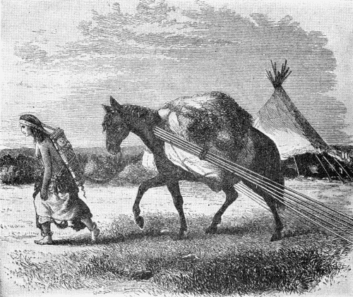
Horses thus laden, and with trailing poles on either side, left a very distinctive trail as they crossed the prairie, and as described: "The trail of the Plain Indians consists usually of three paths, close together, yet at fixed distances apart. They are produced as follows: The framework of their lodges or tents are made of long poles which, on a journey, are tied to each side of a pony, and allowed to trail upon the ground. The result is that a long string of ponies, thus laden and following each other, will wear a triple path—the central one being caused by the tread of the ponies, the two outer by the trailing of the lodge-poles." (Bell, (1), pp. 25-26.) An illustration of a horse so loaded is given on page 26 and is here reproduced as figure 3. It bears the legend "Sioux Indian Lodges or Tents; one packed for a journey, the other standing," and, although crude, conveys a clear conception of the subject.
Fig. 3.—Horse travois.
To continue the narrative of the Stansbury expedition. The party advanced up the river and pursued their journey to the Great Salt Lake and there wintered. The following year they returned to the east and on September 21, 1850, reached the left bank of the North Fork of the Platte, at a point near the center of the present Carbon County, Wyoming. Describing the site of their encampment that night, near the bank of the Platte: "The place we now occupy has long been a favorite camp-ground for the numerous war-parties which annually meet in this region to hunt buffalo and one another. Remains of old Indian stockades are met with scattered about among the thickets; and the guide informed us, that four years since there were at one and the same time, upon this one bottom, fifteen or twenty of these forts, constructed by different tribes. Most of them have since been destroyed by fire. As this was the season of the year when we might expect to find them upon their expeditions, we were on the qui vive, lest we should be surprised." They remained in camp the following day, Sunday, and that evening entered in the journal: "Several herds of buffalo were seen during the day."
The morning of the 23d was warm and cloudy, and the party soon after leaving their camp forded the river "on a ripple, with a depth of eighteen inches." The water was clear, with a pebbly bottom. That this location was frequented by Indians was again indicated by the discovery of another great group of "forts," as told in the narrative: "Immediately above where we crossed, were about twenty Indian forts, or lodges constructed of logs set up endwise, somewhat in the form of an ordinary skin lodge, which had been erected among the timber by different war-parties: they appeared to be very strong, and were ball-proof." (Stansbury, (1), pp. 243-246.) These strongly constructed lodges will at once recall the rather similar structures which stood at some of the Siouan villages, on the Mississippi below the mouth of the Minnesota, during the early years of the last century.
On September 27, when about midway across the present Albany County, Wyoming, the expedition encountered a large number of Indians belonging to a village a short distance beyond. These proved to be the Oglala, and during the following day the village was visited by Stansbury, who wrote in the journal: "This village was the largest and by far the best-looking of any I had ever seen. It consisted of nearly one hundred lodges, most of which were entirely new, pitched upon the level prairie which borders on the verdant banks of the Laramie. No regular order seemed to be observed in their position, but each builder appeared to have selected the site for his habitation according to his own fancy.
"We rode at once to the lodge of the chief, which was painted in broad horizontal stripes of alternate black and white, and, on the side opposite to the entrance, was ornamented with large black crosses on a white ground. We found the old fellow sitting on the floor of his lodge, and his squaw busily engaged over a few coals, endeavouring to fry, or rather boil, in a pan nearly filled with grease, some very suspicious-looking lumps of dough, made doubtless from the flour they had received from us yesterday.... After some further conversation, another chief, named the 'Iron Heart,' rose up and invited us to a feast at his lodge: we accordingly accompanied him, and found him occupying the largest and most complete structure in the village, although I was assured that the Sioux frequently make them much larger. It was intended to be used whenever required, for the accommodation of any casual trader that might come among them for the purpose of traffic, and was accordingly called 'The Trader's Lodge.' It was made of twenty-six buffalo-hides, perfectly new, and white as snow, which, being sewed together without a wrinkle, were stretched over twenty-four new poles, and formed a conical tent of thirty feet diameter upon the ground, and thirty-five feet in height." This must have been a magnificent example of the tipi of the plains tribes, and is one of the largest of which any record has been preserved.
Moving in a southeastwardly direction from the great village, they passed many mounted Indians killing buffalo, and later in the day passed another Oglala village of some 50 lodges, moving southward. The surface of the prairie for many miles was strewn with the remains of buffalo, which had been killed by the Indians and from which only choice pieces had been removed. (Op. cit., pp. 254-257.) They were now ascending the western slopes of the Black Hills, and approaching the region dominated by the Cheyenne, and two days later, September 29, 1850, were a short distance south of a village of the latter tribe.
The region just mentioned, the southeastern part of Wyoming, was traversed by a missionary who, July 24, 1835, encountered a party of 30 or 40 mounted Indians. "They were Ogallallahs, headed by eight of their chiefs, clad in their war habiliments, and presenting somewhat of a terrific appearance.... They told us their whole village was only a few hours' travel ahead of us, going to the Black Hills for the purpose of trading." Late the following day the party overtook the Indians, "consisting of more than two thousand persons. These villages are not stationary, but move from place to place, as inclination or convenience may dictate. Their lodges are comfortable, and easily transported. They are constructed of eight or ten poles about eighteen feet long, set up in a circular form, the small ends fastened together, making an apex, and the large ends are spread out so as to enclose an area of about twenty feet in diameter. The whole is covered with their coarse skins, which are elk, or buffalo, taken when they are not good for robes. A fire is made in the centre, a hole being left in the top of the lodge for the smoke to pass out. All that they have for household furniture, clothing, and skins for beds, is deposited around according to their ideas of propriety and convenience. Generally not more than one family occupies a lodge." (Parker, (1), pp. 66-67.)
Fort Laramie was reached by the Stansbury expedition on July 12, 1849, after advancing about 100 miles beyond the Oglala villages passed six days before. The fort stood on the emigrant road, and was likewise a great gathering place of the neighboring Indians. An interesting account of the visit of a party of emigrants just four years before is preserved: "Our camp is stationary to-day; part of the emigrants are shoeing their horses and oxen; others are trading at the fort and with the Indians.... In the afternoon we gave the Indians a feast, and held a long talk with them. Each family, as they could best spare it, contributed a portion of bread, meat, coffee or sugar, which being cooked, a table was set by spreading buffalo skins upon the ground, and arranging the provisions upon them. Around this attractive board, the Indian chiefs and their principal men seated themselves, occupying one fourth of the circle; the remainder of the male Indians made out the semi-circle; the rest of the circle was completed by the whites. The squaws and younger Indians formed an outer semi-circular row immediately behind their dusky lords and fathers." (Palmer, (1), pp. 25-26.) This was June 25, 1845, and the account of the gathering of emigrants and Indians is followed by a brief description of the fort itself which is of equal interest; "Here are two forts. Fort Laramie, situated upon the west side of Laramie's fork, two miles from Platte river, belongs to the North American Fur Company. The fort is built of adobes. The walls are about two feet thick, and twelve or fourteen feet high, the tops being picketed or spiked. Posts are planted in these walls, and support the timber for the roof. They are then covered with mud. In the centre is an open square, perhaps twenty-five yards each way, along the sides of which are ranged the dwellings, store rooms, smith shop, carpenter's shop, offices, &c., all fronting upon the inner area. There are two principal entrances; one at the north, the other at the south." (Op. cit., pp. 27-28.) Outside the fort proper, on the eastern side, stood the stables, and a short distance away was a field of about 4 acres where corn was planted, "by way of experiment." About 1 mile distant was a similar though smaller structure called Fort John. It was then owned and occupied by a company from St. Louis, but a few months later it was purchased by the North American Fur Company and destroyed. Such were the typical "forts," on and beyond the frontier during the past century.
The Indians would gather about the fort, their skin tipis standing in clusters over the surrounding prairie. Such groups are shown in plate 24, a, b. These two very interesting photographs were made during the visit of the Indian Peace Commission to Fort Laramie in 1868, and it is highly probable the tipis shown in the pictures were occupied by some of the Indians with whom the commissioners treated.
The Black Hills lay north and west of the region then occupied by the Oglala, and although it is known that the broken country was often visited and frequented by parties of Indians in quest of poles for their tipis, yet it seems doubtful if any permanent settlements ever stood within the region. Dodge, in discussing this question, said:
"My opinion is, that the Black Hills have never been a permanent home for any Indians. Even now small parties go a little way into the Hills to cut spruce lodge-poles, but all the signs indicate that these are mere sojourns of the most temporary character.
"The 'teepe,' or lodge, may be regarded as the Indian's house, the wickup as his tent. One is his permanent residence, the other the make-shift shelter for a night. Except in one single spot, near the head of Castle Creek, I saw nowhere any evidence whatever of a lodge having been set up, while old wickups were not unfrequent in the edge of the Hills. There is not one single teepe or lodge-pole trail, from side to side of the Hills, in any direction, and these poles, when dragged in the usual way by ponies, soon make a trail as difficult to obliterate as a wagon road, visible for many years, even though not used." (Dodge, (1), pp. 136-137.)
Col. R. I. Dodge, from whose work the preceding quotation has been made, was in command of the military escort which formed part of the expedition into the Black Hills during the summer of 1875. The traces of the lodges which had stood near the head of Castle Creek, as mentioned in 1875, undoubtedly marked the position of the small encampment encountered by the Ludlow party the previous year. In the journal of that expedition, dated July 26, 1874, is to be found this brief mention: "In the afternoon occurred the first rencontre with Indians. A village of seven lodges, containing twenty-seven souls, was found in the valley. The men were away peacefully engaged in hunting; the squaws in camp drying meat, cooking, and other camp avocations. Red Cloud's daughter was the wife of the head-man, whose name was One Stab. General Custer was desirous they should remain and introduce us to the hills, but the presence among our scouts of a party of Rees, with whom the Sioux wage constant war, rendered them very uneasy, and toward night-fall, abandoning their camp, they made the escape. Old One Stab was at headquarters when the flight was discovered, and retained both as guide and hostage.... The high limestone ridges surrounding the camp had weathered into castellated forms of considerable grandeur and beauty and suggested the name of Castle Valley." (Ludlow, (1), p. 13.) Red Cloud, whose daughter is mentioned above, was one of the greatest chiefs and warriors of the Oglala; born in 1822 near the forks of the Platte, and lived until December, 1909.
Although there may never have been any large permanent camps within the Black Hills district, nevertheless it is quite evident the region was frequented and traversed by bands of Indians, who left well-defined trails. Such were discovered by an expedition in 1875, and after referring to small trees which had been bent down by the weight of snow the narrative continued: "The snow must be sometimes deep enough to hide trails and landmarks, as the main Indian trails leading through the Hills were marked by stones placed in the forks of the trees or by one or more sets of blazes, the oldest almost overgrown by the bark." (Newton and Jenney, (1), p. 302.) And in the same work (p. 323), when treating of the timber of the Hills, it was said: "The small slender spruce-trees are much sought after by the Indians, who visit the Hills in the spring for the purpose of procuring them for lodge-poles."
In another work Dodge described the customs of the tribes with whom he had been in close contact for many years. The book is illustrated with engravings made from original drawings by the French artist Griset, and one sketch shows a few Indians, several tipis, and frames from which are hanging quantities of buffalo meat in the process of being dried. (Dodge, (2), p. 353.) This suggests the scene at Red Cloud's camp. The original drawing is now reproduced as plate 1, the frontispiece.
Assiniboin.
The Assiniboin were, until comparatively recent times, a part of the Yanktonai, from whom they may have separated while living in the forest region of the northern section of the present State of Minnesota. Leaving the parent stock, they joined the Cree, then living to the northward, with whom they remained in close alliance. Gradually they moved to the valleys of the Saskatchewan and Assiniboin Rivers and here were encountered by Alexander Henry in 1775. Interesting though brief notes on the structures of the Assiniboin as they appeared in 1775 and 1776 are contained in the narrative of Henry's travels through the great northern country. In 1775, when west of Lake Winnipeg, Henry wrote: "At eighty leagues above Fort de Bourbon, at the head of a stream which falls into the Sascatchiwaine, and into which we had turned, we found the Pasquayah village. It consisted of thirty families, lodged in tents of a circular form, and composed of dressed ox-skins, stretched upon poles twelve feet in length, and leaning against a stake driven into the ground in the centre. On our arrival, the chief, named Chatique, or the Pelican, came down upon the beach, attended by thirty followers, all armed with bows and arrows and with spears." (Henry, (1), pp. 256-257.) Fort de Bourbon stood at the northwest corner of Lake Winnipeg, and the Assiniboin village of Pasquayah was on the present Carrot River, which flows parallel with the Saskatchewan before joining the larger stream. This was in the eastern part of the province of Saskatchewan.
Early the following year Henry made a visit to an Assiniboin village, to reach which he crossed many miles of the frozen wilderness. He was accompanied by a party of Indians and the short account of the journey contains much of interest. They left Fort des Prairies, "built on the margin of the Pasquayah, or Sascatchiwaine," February 5, 1776, and, as is recorded in the journal, "At noon, we crossed a small river, called Moose-river, flowing at the feet of very lofty banks. Moose-river is said to fall into Lake Dauphin. Beyond this stream, the wood grows still more scanty, and the land more and more level. Our course was southerly. The snow lay four feet deep. The Indians travelled swiftly; and, in keeping pace with them, my companions and myself had too much exercise, to suffer from the coldness of the atmosphere; but, our snow-shoes being of a broader make than those of the Indians, we had much fatigue in following their track. The women led, and we marched till sunset, when we reached a small coppice of wood, under the protection of which we encamped. The baggage of the Indians was drawn by dogs, who kept pace with the women, and appeared to be under their command. As soon as we halted, the women set up the tents, which were constructed, and covered, like those of the Cristinaux.
"The tent, in which I slept, contained fourteen persons, each of whom lay with his feet to the fire, which was in the middle; but, the night was so cold, that even this precaution, with the assistance of our buffalo-robes was insufficient to keep us warm. Our supper was made on the tongues of the wild ox, or buffalo, boiled in my kettle, which was the only one in the camp."