Front matter (continued 3)
Reading edition
Weikert and McCartney went back to the old camp on Otter Creek, where they buried Kenck’s remains and gathered up whatever of value the Indians had left. On their way back, when on the head waters of Black Tail Deer Creek, they met the band of Indians who had just slain Dietrich at Mammoth Hot Springs. A lively skirmish ensued, in which Weikert lost his horse. The two men succeeded in finding refuge in some neighboring brushwood.
Just as the Indians went into camp on the night of August 23d, their first day in the Park, they captured one Shively who was on his way to Montana from the Black Hills. As Shively professed to know the country, which the Nez Percés had never seen before, they impressed him into their service as guide. He was with them thirteen days and claims to have served them faithfully, as well as to have received fair treatment from them. At any rate he won their confidence by his behavior, and was watched so carelessly that he escaped one dark night just as the Indians were crossing the north-east boundary of the Park.
As soon as the command at Henry Lake had become recuperated, the pursuit was vigorously resumed. Howard followed in the track of the Indians as far as to the ford of the Yellowstone; but instead of crossing at this point, he descended the river by the left bank to the site of Baronett’s celebrated first bridge over the Yellowstone. From the Lower Geyser Basin to this bridge a road had to be opened for the wagons. It was a prodigious undertaking, but was performed with astonishing rapidity under the direction of Capt. W. F. Spurgin, Twenty-first Infantry. The bridge was found partially destroyed by the Indians and had to be repaired, after which the line of march was continued up the Lamar and Soda Butte Valleys, and across the divide to the valley of Clark’s Fork.
The authorities had been widely warned of the probable route of the Indians and were lying in wait to intercept them. Gen. Sturgis expected to do this as they emerged from the Absaroka Mountains; but unfortunately he stationed himself in the wrong pass and left the one which the Indians took unguarded. By this loss of time he fell in behind both the Indians and Howard, who was now in close pursuit. The Indians crossed the Yellowstone September 12th. Here Sturgis overtook them with a company of cavalry and a slight conflict ensued. The Indians then struck north, apparently for the British line. On September 23d they crossed the Missouri at Cow Island and resumed their march north. But they were intercepted by Gen. Miles in the Bear Paw Mountains and a severe fight followed, at the northern base of the range on Snake Creek, less than thirty miles from the boundary. The Indians were utterly defeated and Looking Glass was killed. Most of the survivors surrendered unconditionally and the rest escaped across the line. This was on October 5, 1877.
Since the first outbreak, June 13th, three months and twenty-two days had elapsed. The flight and pursuit had extended over 1,500 miles. There had been no fewer than fifteen engagements. The whites had lost 6 officers and 121 soldiers and citizens killed, and 13 officers and 127 soldiers and citizens wounded. A large part of the Indian losses could never be ascertained, but their known losses were 151 killed, 88 wounded and 489 captured.
This celebrated campaign is well intended to elicit the fullest sympathy for the unfortunate Nez Percés. A vast deal of sentiment has been wasted upon the cause of the red man. Opinions have ranged from the extreme views of Catlin, who could see no wrong in the Indian, to those of the rabid frontiersman whose creed was “no good Indian but a dead one.” But, if there ever was a case where sympathy might well incline to the side of the Indian, it is the one under consideration.
The Nez Percés had always been friendly to the whites, and it was their boast that they had never slain a white man. They were intelligent, brave, and humane. In this campaign they bought supplies which they might have confiscated; they saved property which they might have destroyed; they spared hundreds of lives which other Indians would have sacrificed. If some of the more lawless element committed various outrages, they might justly reply that the whites had fired into their tents where their women and children were sleeping. In short, their conduct in this campaign places them in all respects vastly nearer the standard of civilized people than any other of the native tribes of the continent.
In estimating the causes that led to the war, history can not fail to establish that the Indians were in the right. It was a last desperate stand against the inevitable destiny which was robbing the Indian of his empire; a final protest against the intolerable encroachments of the pale face. In defense of this principle, the Nez Percés staked their all on a single throw. They lost, and were irretrievably ruined. They were transported to a distant territory, and the land of their fathers they saw no more. [AS]
The campaign of 1877 was the only one in which tourists of the National Park were ever subjected to serious danger from the Indians. It has left its mark indelibly upon the Park. “Nez Percé Creek” will always remind the traveler of the terrible danger in which another party of tourists was once placed upon the borders of that stream. “Howard’s Trail” will not soon be effaced from the forests and mountains where Captain Spurgin, with brilliant expedition, built the first passable highway through that tangled wilderness.
In 1878, there was a slight alarm in the Park caused by an ephemeral raid of the Bannock Indians; but, beyond the loss of a few horses, no damage was done.
CHAPTER XIV.
ADMINISTRATIVE HISTORY OF THE PARK.
The Act of Dedication of the Yellowstone National Park indicates in clear terms the purposes for which it was created. These are:
(1.) The preservation of its natural curiosities, its forests, and its game.
(2.) The reservation of its territory from private occupancy so that it may remain in unrestricted freedom “for the benefit and enjoyment of the people.”
(3.) The granting of such leases and other privileges as may be necessary for the comfort and convenience of visitors.
One grave omission in the original act, and the long-continued failure of Congress to remedy it by subsequent legislation, in a large degree nullified these important purposes. Strange as it may seem, for twenty-two years, or until the spring of 1894, there was no law defining offenses in the Park or providing a penalty for their commission. Wanton vandalism, destruction of game, or burning of forests, could be visited with no heavier punishment than ejection from the Park and confiscation of “outfit.” In the reports of every Superintendent, for more than a score of years, this condition of affairs was brought to the attention of Congress. Meanwhile there were experienced all the evils of a license which at times was wholly unchecked and which has never until very recently been under proper control.
This long-standing misfortune was aggravated by another scarcely less serious—the failure of Congress for several years to appropriate funds for the protection and improvement of the Park. For this failure, however, no one can justly be held faultily responsible. The promoters of the Park project had based extravagant expectations upon the results to be derived from leases. They believed that the revenue from this source would amply cover the expense of opening the necessary highways and providing a proper police force. They did not make due allowance, for the fact that there was at that time no railroad within 500 miles; that the new reservation was an almost impassable wilderness, and that the construction of roads and bridges must necessarily precede any profitable tourist business. Neither do they seem to have realized that these leases could not, in the nature of things, yield a revenue commensurate with the work of opening up so wild and extensive a country. The argument of self-support was a mistaken one. It did an important work, however, for it is doubtful if Congress would have created this reservation had it not believed that no additional public burden was to be incurred thereby.
The subsequent results of this erroneous impression were in every way unfortunate. It was several years (1872 to 1878) before any money was appropriated for the Park, which, in the meanwhile, was left wholly without means for its improvement and protection. The Secretary of the Interior might indeed publish rules and regulations for its government, but they could avail but little so long as there was no authority to carry them into execution. In fact, the only valuable result of the creation of the Park during these years was the exclusion of settlers from its territory.
Shortly after the Park was created, the Hon. N. P. Langford was appointed its first Superintendent. The selection was in every sense an admirable one. Mr. Langford had been a member of the famous Washburn Expedition, and an earnest worker in securing the Act of Dedication. He was intimately acquainted with all phases of western life, and was an enthusiast upon the subject of his new charge. But, from the first, his hands were completely tied. No money was ever allowed him for his services, nor for any other form of expenditure in the interests of the Park. He was, therefore, powerless to accomplish effective work. His office, which he held for about five years, was a source of great annoyance to him; for he was frequently, and most unjustly, charged in the public press with the responsibility for a condition of things for which he was in no sense to blame.
In 1877, there appeared, as Mr. Langford’s successor, one of the most unique and picturesque, as well as one of the most important, characters in the history of the Park. This was Philetus W. Norris, of Michigan. He was appointed immediately upon the advent of President Hayes' administration, and held office very nearly five years, or almost exactly the same length of time as his predecessor.
Norris filled with varying capacity the rôles of explorer, path-finder, poet, and historian in the Park. He was a man of extraordinary energy, and, if not in the fullest sense a practical man, he had at least the invaluable quality of being able to produce results. He entered upon his new field of duty with a genuine enthusiasm, and he was fortunate in receiving from Congress substantial means with which to carry out his plans.
The work of Norris' administration may be conveniently considered under three heads: his discoveries, his road building, and his reports.
He was pre-eminently an explorer. He not only traveled repeatedly over all the known trails, but he penetrated the unknown sections of the Park in every direction. Though not the discoverer, he first made generally known the geyser basin that bears his name. He explored and reported upon the Hoodoo region, and first called prominent attention to the noble cañon of the Middle Gardiner. But the most important feature of his explorations was the study he made of the history and antiquities of the Park. We owe more to him than to any one else for evidence of the former presence of white men in that region. His discoveries also in the matter of prehistoric races and of early Indian history possess scientific value.
In the rôle of road builder, Norris was a pioneer in the Park. Before his time, wagons could get up the Gardiner to Mammoth Hot Springs, and up the Madison to the Lower Geyser Basin. He opened the way direct from Mammoth Hot Springs to the Upper Geyser Basin, from the Lower Basin to the Yellowstone River, Lake, and Falls, and from Mammoth Hot Springs to Tower Creek. He thus shortened the old pack-train route by one-third, and foreshadowed the general road system which Lieutenant Kingman later formulated into a permanent project of improvement. As a road engineer, he was not a distinguished success. His work was ill-conceived and poorly executed, but at the same time it gave access to many places wholly inaccessible before. All the difference between poor roads and none at all may justly be placed to his credit.
The third and most important feature of Norris' work was his official reports and other writings. As he was always doing something, although seldom in the best way, so he was always saying something, with the same constitutional defect. Nevertheless, he has left in his five annual reports a great deal of useful information, which he supplemented by a long series of articles in the Norris Suburban, a paper at that time largely read throughout the West. It is not too much to say that he was a prime mover in the strong awakening of public sentiment in regard to the Park which began to show itself toward the close of his administration.
Norris' work in the Yellowstone Park can not be passed over without praise. It left its mark, as its author did his name, in every quarter. But one thing must be charged to his account—an almost total failure to protect the Park. He did, indeed, by his public utterances, denounce the vandalism and game destruction that were then rampant; but he did little in a practical way to prevent them—no more, in fact, than his predecessor, although he was given the means.
Norris was succeeded in February, 1882, by Patrick H. Conger, of Iowa. Of this Superintendent, it need only be said that his administration was throughout characterized by a weakness and inefficiency which brought the Park to the lowest ebb of its fortunes, and drew forth the severe condemnation of visitors and public officials alike. This administration is an important one, however, for it marks the period of change in public sentiment already referred to, and the commencement of reform in the government of the reservation.
As if the unfortunate condition of affairs due to the lack of suitable laws for the reservation were not enough, there arose in the early part of Superintendent Conger’s administration a new and even more formidable danger, under the euphemistic title of the Yellowstone Park Improvement Company. Previous to this time, there had been no regular leases in the Park. Several informal permits for occupancy had been granted, and a small number of inferior buildings had been erected. In 1880, there were nine of these buildings, nearly all of them being plain log-cabins, with earth roofs, of the common frontier pattern. Only two, the headquarters building at Mammoth Hot Springs and Marshall’s Hotel in the Lower Geyser Basin, rose in dignity above the primitive type. No one as yet thought of remaining in the Park during the winter season.
But it finally dawned upon certain sagacious individuals that here was a rare opportunity to exploit the government for their private emolument under the generous guise of improving the Park, and catering to the comfort of the tourist. A company was accordingly formed, and a valuable ally secured in the person of the Assistant Secretary of the Interior, who granted a lease of 4,400 acres in tracts of about a square mile at each of the great points of interest. It was urged in defense of this sweeping grant, that it was hoped in that way to secure the protection which had yet failed to be found by any other method. It was thought that, if responsible parties could be given exclusive control of these natural curiosities, they would, at least from motives of self-interest, preserve them. But such a monopolistic privilege was clearly opposed to the spirit of the Act of Dedication. Why set apart this region for the free and unrestricted enjoyment of the people, if the Secretary of the Interior could give to private parties absolute control of all its most important localities? Was this a proper interpretation of “small parcels of ground,” as specified in the act? The danger involved in this action was indeed a grave one, and it at once aroused a storm of protest throughout the country.
It was about this time also that there began to appear those various railroad and segregation projects which from that time to the present have been a formidable menace to the continued existence of the Park. A more extensive consideration of this particular subject is reserved for a later chapter.
It thus became apparent as early as 1882, that immediate and radical measures must be adopted if the Park was to be preserved in its original condition. General Sheridan who passed through that region in 1881, 1882, and 1883, gave forcible warning of the impending danger, and urgently appealed to the public sentiment of the country in favor of some action which should avert it. The Governor of Montana made an earnest appeal to Congress. Other influential voices united in the same cause, and already it was broadly hinted that the only salvation of the Park lay in turning it over to the military. The whole matter was brought prominently before the next Congress, and in March, 1883, a clause in the Sundry Civil Bill containing the annual appropriation for the Park, forbade the granting of leases of more than ten acres to any single party, authorized the Secretary of the Interior to call upon the Secretary of War for troops to patrol the Park, and provided for the employment of ten assistant superintendents who were to constitute a police force. Thus was the bold scheme of the Improvement Company frustrated, and the foundation laid for the present administrative system. The Secretary of the Interior, however, seems not to have wished to avail himself of military assistance, and it was several years before this provision of the law was put into operation.
It was in this same year that the killing of birds and animals in the Park, and the taking of fish by any other method than by hook and line, were absolutely prohibited. Previously, hunting had been allowed so far as was necessary to supply the wants of camping parties—a concession that practically operated as an unrestricted license.
The failure of Congress to enact needed legislation at length became so nearly chronic that relief was sought in another direction. Nearly all the territory of the Park, and all its great attractions, were within the limits of Wyoming. Might it not therefore be within the province of territorial legislation to furnish the necessary legal protection? The subject was agitated, and in the winter of 1884, an act was passed, designed “to protect and preserve the timber, game, fish, and natural curiosities of the Park,” and for other purposes. The act was very stringent in its provisions, and clearly indicated the deep-seated nature of the disease which it has designed to cure. But it totally failed of its purpose. The attempt at territorial control of what was really a national institution was in itself a grave blunder. Then, the officials chosen to execute the law seem to have been poorly qualified for the purpose, and to have displayed lamentable want of tact and moderation. Some of their arrests were so tyrannical and inexcusable, as to create universal protest. The spectacle of the assistant superintendents—federal officials—sharing, as informers, the fines levied by a territorial court, was not designed to create respect for the new authority. At length the unpopularity of the law became so extreme, that it was repealed March 10, 1886.
Although so unwise a measure could not stand, the first effect of its repeal was to advertise the fact that the Park was practically without legal protection. Matters became even worse than before. The common verdict, as gathered from official reports and other sources, is that the body of police, styled assistant superintendents, were notoriously inefficient if not positively corrupt. They were, for the most part, creatures of political favoritism, and were totally unused to the service required of them. Commissioned as guardians of the rarest natural wonders on the globe, they not infrequently made merchandise of the treasures which they were appointed to preserve. Under their surveillance, vandalism was practically unchecked, and the slaughter of game was carried on for private profit almost in sight of the superintendent’s quarters. Already some of the rarer species of animals had suffered a depletion in numbers from which they have never recovered; and the prediction of Prof. Comstock, in 1874, seemed on the point of realization, that “the zoological record of to-day” was about to “pass into the domain of the paleontologist.”
The difficulties that beset the administration of the Park seem to have been too great for Superintendent Conger to grapple with successfully, and he resigned, July 28, 1884. It may at least be said in his favor, that, weak as his management had been, no charge of corruption or dishonesty was ever brought against him.
In his place was appointed, August 4, 1884, Robert E. Carpenter, of Iowa. Mr. Carpenter’s views of the requirements of his office were clear and positive; and he promptly set about to carry them into execution. In his opinion, the Park was created to be an instrument of profit to those who were shrewd enough to grasp the opportunity. Its protection and improvement were matters of secondary consideration. Instead of remaining at his post during the winter season, he went to Washington, and there, in concert with a member of the Improvement Company, very nearly succeeded in carrying a measure through Congress by which important tracts upon the Reservation were to be thrown open to private occupancy. So confident of success were these conspirators that they even located claims upon the tracts in question, and their names appeared on claim notices posted to designate the localities. Fortunately the measure failed of passage, but the scandal of Superintendent Carpenter’s conduct led to his prompt removal from office.
On the day of his removal, May 29, 1885, Colonel David W. Wear, of Missouri, was appointed to the vacancy. Colonel Wear appears to have been admirably fitted for the place. He at once set out to reform the administration of the Park, and his intelligent and vigorous measures gave the highest encouragement to those who had been familiar with the previous condition of affairs. But, as has often happened before, and will often happen again, he was made to suffer for the sins of his predecessors. The bad repute into which the government of the Park had fallen was not easily removed, and Congress finally declined to appropriate money for a protection which did not protect. The Secretary of the Interior was thus compelled to call upon the Secretary of War for assistance. The régime of civilian superintendents passed away, and that of the military superintendents began. The change was bitterly opposed by the Secretary of the Interior and by all who held or hoped to hold places under the old order; but the sequel quickly proved the wisdom of this action of Congress. The old order necessarily felt the evil of our patronage system of office-holding; but no single act ever went so far to eliminate this fruitful source of misfortune as the assignment of the administrative control of the Park to the officers and soldiers of the army.
August 20, 1886, marks the turning point in the administrative history of the Reservation. It was upon that day that Captain Moses Harris, First U. S. Cavalry, relieved the civilian Superintendent of his duties, and soldiers supplanted the so-called assistant Superintendents as a Park police. Henceforth an entirely new order was to obtain. It was to be seen how much could be accomplished, even in the absence of laws, toward a vigorous and healthful administration. Trespassers upon the Reservation were promptly removed. The regulations were revised and extended, printed upon cloth, and posted in all parts of the Park; and their violation was visited with summary punishment to the full extent of the Superintendent’s authority. Abuses of leasehold rights were searchingly inquired into and reported to the department. As soon as this show of real authority was made manifest, and it became apparent that here was a man who meant what he said, a great part of the difficulty was over. Nothing in fact conduces so much to the infraction of law as a belief in the incompetency or dishonesty of those delegated to enforce it, and the removal of this cause was a long step in the right direction.
The Park was particularly fortunate in its first military Superintendent. Captain Harris possessed in a marked degree the qualities required for that position. He was vigorous and uncompromising in suppressing lawlessness, just and impartial in his rulings, and untiring in his watchfulness for the public interest. Although his immediate superior, the Secretary of the Interior, had strenuously opposed the installation of the military in the Park, he never failed to pay a high tribute to the efficiency with which the new Superintendent performed his duties. In fact, this high opinion of Captain Harris' services was soon shared by all who were familiar with the situation. Even Forest and Stream, whose fidelity to the best interests of the Park has been a distinguishing feature of that journal for the past fifteen years, was fain to admit, although it had regarded the change as impolitic, that under Captain Harris' guardianship “the Park had been cared for as it never had been before.”
Captain Harris remained in charge for nearly three years, and was succeeded, June 1, 1889, by Captain F. A. Boutelle, First U. S. Cavalry. That the evil of political interference and private intriguing was not yet wholly eliminated from the affairs of the Park became manifest when Captain Boutelle undertook to enforce the regulations against a prominent employe of the hotel company. For causes not publicly understood, he was unexpectedly relieved from duty January 21, 1891, and Captain George S. Anderson, Sixth U. S. Cavalry, the present Superintendent, was assigned in his place.
Going back now to the Yellowstone Park Improvement Company, the history of that erratic concern will be briefly traced. It is important first to state, however, that the conduct of private business in the Park has, until recent years, been most unsatisfactory. The Park was long unfortunate in the men who sought to carry on business within its borders, and even yet it is not wholly free from the evil of unscrupulous and dishonest schemers. The strife, backbiting, struggle to ruin each other, which seemed to be the chief purpose of those who at first sought government favors on the Reservation, can be understood only by those who have seen them, or have gone to the trouble to examine official correspondence. More than once has the government made these troubles the subject of special investigation, although generally with indifferent results.
The new hotel company had a meteoric career, promising great things, but effecting no permanent improvement except the partial construction of the Mammoth Hot Springs Hotel. Its fortunes early collapsed, and the opening of the tourist season of 1885 found the great building in the possession of unpaid workmen, who held it under a kind of military guard until their wages should be paid.
This company, and other lesser concerns, gradually transferred their rights to a new company, called the Yellowstone Park Association, which is still in operation. It is largely identified with the Northern Pacific Railroad, and although it has a practical monopoly of the tourist business, it has never subjected itself to the charge of using that monopoly to the disadvantage of the public. From the old and unsatisfactory condition of things it has built up a hotel system which, though incomplete, is far ahead of what could be reasonably expected in a region so remote from the great centers of civilization.
It was in the early part of Conger’s administration that the government took up in earnest the question of road construction. For some years, the public, thoroughly weary of Norris' roads, had been urging the necessity of sending an engineer officer to take charge of that important matter. This agitation bore fruit in 1883 in the assignment of Lieutenant D. C. Kingman, of the Corps of Engineers, to the charge of this work. His tour of duty ran through three years, and resulted in the greatest improvement to the road system. He prepared the project which has served as a basis of all subsequent work, and he did much toward carrying it into execution. His reports were especially valuable, not only in matters connected with his particular work, but also those pertaining to the general welfare of the Reservation. He was among the first to lift a warning voice against the grave danger of railroad encroachment, and no one since his time has presented this matter in a more convincing light.
The years 1894 and 1895 have brought a radical improvement to the administrative status of the Park. May 4, 1894, the long desired code of laws was enacted. On August 3d of the same year, an act was passed further regulating the question of leases and removing the most serious defects of previous legislation. In the autumn of the same year, the road work was taken from the charge of a non-resident engineer with headquarters in St. Paul, and placed in direct charge of the Superintendent, thus bringing the entire administrative control under a single head.
These two years have also witnessed a decided check to the schemes of those who still persist in believing that the Park was created for their personal aggrandizement. Strong adverse reports have been submitted, practically for the first time, by Congressional Committees against the so-called Segregation project, the admission of railroads into the Park, and the construction of an electric railway therein.
With the exception of the lack of a sufficient force of scouts properly to patrol that region, the condition of affairs on the Reservation is now eminently satisfactory—far more so than at any previous period.
CHAPTER XV.
THE NATIONAL PARK PROTECTIVE ACT.
One of the most important milestones in the history of the Park has been so recently set that the public is as yet not fully conscious of its existence. It has already been stated that for more than twenty years the Park was wholly without adequate statutory protection; and that this long-standing defect was finally remedied by the enactment of a comprehensive measure in the spring of 1894. The circumstances attending the passage of this Act, and the prompt manner in which a great misfortune was changed into a lasting benefit, form one of those singular instances of good fortune which have so largely characterized the history of this region.
Bills providing suitable protection for the Park were introduced at the First Session of the Fifty-third Congress, just as they have been for the past twenty years, and apparently with not much greater chance of success. The wanton recklessness of those who seek special privileges in the Park, and are unwilling that any measure for its welfare shall pass unless coupled with their own private schemes, threatened this time, as hitherto, to defeat Congressional action. But an unforeseen event, of such powerful bearing as practically to override all opposition, occurred in March, 1894, and quickly brought about the desired consummation.
It is well known that the only herd of bison, now roaming in their native condition within the present limits of the United States, is in the Yellowstone National Park. There has always been a lively interest in the preservation of this herd, and its extinction would be regarded as a deplorable calamity. With proper protection, it will undoubtedly flourish, but there is no margin for carelessness or neglect.
During the winter of 1894, Captain George S. Anderson, U. S. A., Superintendent of the Park, learned that snow-shoe tracks had been seen along Astringent Creek in the Pelican Valley east of the Yellowstone River, in territory ranged over by the buffalo in winter. The same tracks were seen near Soda Butte station pointing toward Cooke City. Inquiry proved them to have been made by one Howell, a well-known poacher and lawless character, who was evidently driving his trade in the winter buffalo country. It was apparent that he had left the Park for supplies and would soon return. Captain Anderson accordingly laid his plans for capture.
There has been given a brief account of the winter expedition through the Park in the spring of 1894, of which Mr. F. J. Haynes and Scout Burgess were members. Burgess was instructed to examine the country east of the Yellowstone and obtain, if possible, a clue to Howell’s whereabouts. Early on the morning of March 12th, he set out from the Lake hotel with a single companion, Private Troike, of the Sixth Cavalry, and before it was scarcely daylight struck a dim snow shoe trail in the valley of Astringent Creek. Soon after, he found the poacher’s teepe and a number of buffalo heads hung up, by means of a pulley, to the limb of a tree so as to be out of the reach of wolves. Every thing indicated that the poacher was there for a business of some duration and magnitude.
Leaving the teepe and following Howell’s morning trail for some distance, Burgess' attention was soon arrested by six rifle reports. These six shots slew five buffalo. Burgess soon discovered Howell, engaged in skinning the head of one of the buffalo. His rifle was leaning against another some fifteen feet from him. A dog (but this Burgess did not know) was coiled up under the leg of a buffalo. Burgess thus had the dangerous duty to perform of crossing the intervening space of some four hundred yards, where there was no cover and where he might easily be seen by Howell or the dog. Considering the desperate character of these poachers, and the fact that Burgess was armed only with a revolver as against Howell’s rifle, the peril involved in this capture may be easily appreciated. But fortune was on Burgess' side. A heavy storm was on, and the wind was blowing direct from Howell to Burgess. This prevented the dog from scenting approach, and Howell from hearing any noise, from the leeward. Burgess did not stop to reckon the chances of success, but promptly sallied forth upon his intended victim. On his way he ran upon an open ditch about ten feet wide. To make a snow shoe jump on level ground is a feat of much difficulty; but Burgess managed to accomplish it. By good fortune nothing happened to arouse Howell, and Burgess got within fifteen feet of him before he was aware that there was any one within as many miles. With Burgess' cocked revolver over him, he discreetly surrendered. Private Troike was summoned, the rifle and accoutrements were seized, and the party set out at once for the Lake hotel. But such are the difficulties of snow shoe travel in this region, that it was long after dark before they reached their destination.
The Yellowstone Park Association keeps a solitary watchman at each of its hotels during winter, and has a telephone line connecting each with Mammoth Hot Springs. By virtue of this lucky fact, Howell’s capture, though made some sixty miles from the nearest telegraph station, and in a region where winter travel is impossible except on snow shoes, was made known to the Superintendent before 9:30 P. M. that day. By another stroke of good fortune a representative of Forest and Stream was at that moment present at Mammoth Hot Springs. He had arrived but two days before and remained a guest of the Superintendent prior to a tour of the Park, which began two days later. The news of Howell’s capture was at once put on the wire, and in less that twenty-four hours, Forest and Stream was represented in Washington with a new and powerful argument for the passage of the Offenses Bill. The imminent danger of the speedy and entire extinction of the only remaining herd of buffalo in the country produced the desired effect in Congress, and on May 7, 1894, the bill became a law.
It was throughout a most fortunate combination of circumstances that made this consummation possible. A Superintendent thoroughly devoted to the care of his important charge, and fearless in the execution of his duty; a scout who had the nerve to make an arrest full of peril to himself; the existence of a winter telephone line to the heart of that inaccessible region; the presence at Mammoth Hot Springs of a representative of that journal which holds first rank among the protectors of the Park; and uncommon good, luck in minor details, caused this important event to cast its influence into the national councils almost before the echo of the poacher’s rifle shots had died away among the mountains. Howell’s act was a misfortune—a grievous misfortune—to the game interests of the Park; but its immediate result in legislation will prove a benefit of far greater consequence.
Howell was brought to Mammoth Hot Springs and was there imprisoned in the Fort Yellowstone guardhouse, and his case reported to Washington. As there was no law for his trial and punishment, the Secretary of the Interior in due time ordered his release. He was accordingly put out of the Park and forbidden to return without permission. But with his habitual disregard of authority, he came back during the following summer and was discovered by the Superintendent in a barber’s chair at Mammoth Hot Springs Hotel. He was promptly arrested and tried under the new law for violating the orders of the Superintendent in returning. He was convicted and sentenced to one month’s imprisonment and fifty dollars fine. He thus became the Park Haman—first to be hanged upon the gallows of his own building.
Howell appealed the case to the U. S. District Court sitting at Cheyenne, Wyoming, and was released upon the technical ground that, as the prohibition against returning to the Park was merely an order from the Superintendent, and not explicitly authorized by the regulations of the Secretary of the Interior, the offense did not come within the purview of the law. This defect in the regulations has since been remedied and the conviction of Howell, therefore, notwithstanding his final release, has all the force of precedent.
PART II.—Descriptive.
CHAPTER I.
BOUNDARIES AND TOPOGRAPHY.
At the time when the bill creating the Yellowstone Park was before Congress there had been no detailed survey of that region, and the boundaries, as specified in the bill, were to some extent random guesses. The exploring parties of 1870 and 1871 had seen all the more important points of interest. To include these in the proposed reservation, the framers of the bill passed two lines due east and west, one through the junction of the Yellowstone and Gardiner Rivers, and one through a point ten miles south of the most southerly point of the Yellowstone Lake; and two lines due north and south, one through a point ten miles east of the easternmost point of Yellowstone Lake, and one through a point fifteen miles west of the most westerly point of Shoshone (then called Madison) Lake. The nearly rectangular area thus resulting was found to lie mainly in the north-west corner of Wyoming, with narrow strips, two or three miles wide, overlapping into the Territories of Montana and Idaho. The mean dimensions of the Reservation were 61.8 miles by 53.6 miles, giving an area of 3312.5 square miles.
By presidential proclamation, dated September 10, 1891, a large area to the east and south of the Park was set apart as a Forest Reserve, under the provisions of an Act of March 3, 1891, and was placed in charge of the Superintendent of the Park. By this action the area reserved from settlement around the sources of the Yellowstone was increased to about 5,000 square miles. It should be remembered, however, that this additional reserve is not a direct creation by Act of Congress, and it therefore does not stand upon the same substantial footing as the original Reservation.
The chief topographical features of the Park are as follows:
DRAINAGE AREAS.
Three great rivers receive the waters of the Yellowstone Park—the Yellowstone, the Missouri, and the Snake. The first two rivers are on the Atlantic slope; the third is on the Pacific slope. The areas drained by them are approximately:
By the Yellowstone,1,900 square miles.
By the Missouri,730 square miles.
By the Snake,682 square miles.
The Yellowstone River has its source in the snow drifts of Yount Peak, twenty-five miles south-east of the Park. It enters the Reservation six miles west of the south-east corner; crosses it in a direction somewhat west of north, and leaves it at a point about nineteen miles east of the north-west corner. Near the center of the Park it flows through the celebrated lake of the same name, and further north passes through two remarkable cañons before it leaves the Reservation. Its principal tributaries within the Park are the Lamar River (commonly called the East Fork), from the east, and Gardiner River from the west. The Lamar River rises nearly due east of the outlet of Yellowstone Lake and flows north-westerly, joining the main stream near Junction Butte. Its principal tributary is Soda Butte Creek, which rises just outside the north-east corner of the Park and joins the Lamar River near the extinct hot spring cone from which it derives its name.
Gardiner River is the second largest tributary of the Yellowstone, and drains the extensive area between the Washburn and Gallatin Mountains.
The low-water discharge of the Yellowstone River, as measured by the writer, in 1891, a little below the lake outlet, is 1,598 cubic feet per second; as measured by the United States Geological Survey, in 1886, 1,525 cubic feet. The discharge at the north boundary of the Park can not be less than 2,000 cubic feet.
The Missouri River drainage flows into the Gallatin and Madison forks of that stream. The Gallatin drains only a small area in the extreme north-west corner of the Park. The Madison is formed by the junction of the Gibbon and Firehole Rivers, about twelve miles east of the west boundary of the Park. The Gibbon takes its rise a few miles west of the Falls of the Yellowstone, and flows in a south-west direction. The Firehole rises in Madison Lake, and flows north to its junction with the Gibbon. Its principal tributaries are the Little Firehole River and Iron Creek on the west, and Nez Percé Creek on the east.
The Snake River drains the south-west portion of the Park. It rises about fifteen miles south of Yellowstone Lake, just outside the Park. It then takes a northerly circuit into the Park, receiving the waters of Hart and Lewis Rivers, and leaves the Reservation just north of Jackson Lake. Its principal tributary is the Lewis River, which drains Shoshone and Lewis Lakes. Several large streams, Bechler and Falls Rivers among them, cross the south-west boundary of the Park and join the main Snake further south.
The line of separation between this water-shed and those of the Yellowstone and the Missouri, is the Continental Divide, the irregular course of which can be readily understood by consulting the map.
In the entire Park there are about thirty-six named lakes with a total area of nearly 165 square miles. Of these lakes, twenty-one, with an area of 143 square miles, are on the Yellowstone slope; eight, with an area of perhaps two square miles, are on the Missouri slope; and seven, with an area of about twenty square miles, are on the Snake River slope. The four principal lakes—Yellowstone, Shoshone, Lewis, and Hart—are clustered near the Continental Divide at its lowest point, the first being on the Atlantic slope, and the others on the Pacific.
There are upon the various streams of the Park no fewer than twenty-five interesting water-falls, where the streams descend from the Park plateau to the lower surrounding country.
MOUNTAIN SYSTEM
As the Yellowstone River is the most important stream in the Park, so the Absaroka Range, in which it has its source, is the most important mountain system. It extends north and south along the entire eastern border. To the south it is prolonged under the name of the Sierra Shoshone Mountains as far as the Wind River Valley, while north of Soda Butte Creek it extends to the Great Bend of the Yellowstone under the name Snowy Range. The various larger summits are remarkably uniform in elevation. From Index Peak on the north to Yount Peak on the south, there are more than thirty named mountains with an average altitude of 10,400 feet. The variation from this mean is slight. The range, throughout its length, is full of noble views, and, as seen from across the Yellowstone Lake, is one of the finest exhibitions of mountain scenery on the continent.
The next most important range is the Gallatin, situated in the north-west corner of the Park, at the head of the Gallatin River. It has about seventeen named peaks, with an average altitude of 9,800 feet. The highest peak, Electric, is the loftiest mountain in the Park.
The Washburn Range, a detached mountain system, originally known as the “Elephant’s Back,” is situated between the Grand Cañon of the Yellowstone and the Gardiner River. It has seven christened summits, with an average altitude of 9,800 feet. The most conspicuous peak of the range, as well as the most noted mountain of the Park, is Mt. Washburn.
The Red Mountain Range is a small, detached group of mountains between Hart and Lewis Lakes. Its principal summit, Mt. Sheridan, affords probably the finest view to be had in that entire region.
The Teton Range lies mainly outside the Park, its northern spurs barely touching the southern boundary. It extends north and south along the west shore of Jackson Lake, and is a very noted range of mountains. Its highest summit, the Grand Teton, has no competitor for altitude nearer than Fremont Peak, seventy-five miles distant.
The Big Game Ridge lies along the south boundary of the Park, and is the source of the Snake River. It has six named peaks, with an average altitude of 9,800 feet.
Besides these various groups of mountains, there are a few detached peaks worthy of note, which can not be conveniently classified with any of the principal ranges.
PLATEAUS.
A considerable portion of the Park area is composed of what may be termed plateaus, elevated tracts of land, not so high as the mountain ranges, but much higher than the valleys. Ordinarily, these are to be found along the divides between the larger streams. The more important are the Pitchstone Plateau, between the Snake River and the head waters of the Bechler and Fall Rivers, with a mean altitude of 8,500 feet; Highland Plateau, between the Yellowstone and the Madison Rivers, altitude 8,300 feet; Mirror Plateau, between the Yellowstone and the Lamar Rivers, altitude 9,000 feet; Mt. Everts Plateau, between the Yellowstone and the Gardiner, altitude 7,000 feet; and the Madison Plateau, west of the Lower Geyser Basin, altitude 8,300 feet.
VALLEYS.
These form an exceedingly important part of the Park topography. The largest is Junction Valley, including its branches along the Yellowstone and the Lamar Rivers. It is an extensive, grassy tract, stretching well back upon the mountain sides, and forming a fine pasturage for game. For scientific research, its fossil forests and other features make it an extremely interesting section.
Hayden Valley is the next in size and importance, and occupies an important tract along the Yellowstone River, between the Lake and Falls, mostly on the west side, in the vicinity of Alum Creek.
The Madison Valley, and its extensions up the Firehole and Gibbon Rivers, are chiefly noteworthy as being the locality of the three great geyser regions of the Park.
The Swan Lake Flats, Willow Park, the Shoshone and Falls River Basins, are other important examples of typical mountain valleys.
ALTITUDES.
The lowest point in the Park is at the junction of the Yellowstone and the Gardiner Rivers, 5,360 feet above sea level; the highest is the summit of Electric Peak, six miles distant, 11,155 feet. To give a general idea of the altitudes of different points in the Park, particularly of those which the tourist visits, the following list is presented: [AT]
Gardiner, Mont. 5,400feet.
Mammoth Hot Springs hotel 6,215"
Glen Creek Bridge above Golden Gate 7,245"
Indian Creek Bridge 7,275"
Beaver Lake 7,360"
Norris Road Junction 7,470"
Gibbon Meadows 7,315"
Gibbon and Firehole Rivers, junction of 6,780"
Lower Geyser Basin (mouth of Nez Percé Creek) 7,125"
Upper Geyser Basin (near Castle Geyser) 7,300"
Mouth of Spring Creek 7,600"
Isa Lake, Continental Divide 8,300"
Yellowstone Lake 7,741"
Road at Mud Volcano 7,705"
Cañon Hotel 7,850"
Junction Valley near Yancey’s 6,150"
Divide between the Black-tail and Gardiner 6,550"
SCENERY.
The mountain scenery of the Park is not so imposing as that of Colorado and some other parts of the Rocky Mountain region; but it is more varied and beautiful. The eye is not wearied with the constant sight of vast and bare mountain cliffs, but finds relief in attractive lakes, streams, glades, parks, forests, and every combination of effects that helps to produce a beautiful landscape.
CHAPTER II.
Geology of the Park.
Nature seems, from the first, to have designed this region for a mountain park. In geological chronology it was near the close of the Cretaceous Period, that the lifting of the great mountain systems of the West into their present positions was practically finished. In the formation of these mountains, the general outline of the Yellowstone Park was already marked out, probably in much more striking features than at present. A vast rim of mountains, visible now in the Absaroka, Snowy, Gallatin, Teton, and Snake River Ranges, hemmed in the extensive area which has since become so famous. Subsequent events have greatly modified its original form, but the grand outlines at first determined are still distinctly visible.
In the Tertiary Period, which was next in order of time after the Cretaceous, changes of the greatest importance occurred, consisting principally in the outpouring of enormous masses of volcanic material. The origin of these lava flows has been traced to a few craters, one of which was near Mt. Washburn, another in the Red Mountain Range, and a third near the sources of the Lamar River. Mt. Washburn has long been recognized as part of the rim of an ancient volcano. Both it and Mt. Sheridan, the two mountains which bore the principal part in working out the present features of that country, still remain the most prominent peaks from which the modern visitor can contemplate the work they have performed.
The outpourings at first consisted of andesitic lavas. They largely changed the appearance of the mountain ranges and to some extent filled up the interior basin. The flows were not continuous but were separated by long intervals of quiet, during which vegetation and the agencies of erosion were actively at work.
After the cessation of the andesitic eruptions, a quiescent period of great length ensued. Then came the period of rhyolitic flows, the centers of volcanic activity being as before Mts. Washburn and Sheridan. These flows built up the present Park plateau, and constitute the great bulk of the rocks which the tourist now sees.
Following the period of rhyolitic eruptions, orographic agencies were active in producing extensive faults or displacements, which in certain localities radically changed the relative positions of the rocks.
The last exhibitions of volcanic energy were in the form of basaltic eruptions. These took place in part through ordinary volcanic craters, and in part through cracks or seams in the rocks, where they may still be seen forming extensive dykes. The basalt is of relatively limited extent, but its striking and picturesque forms wherever it appears make it more interesting to the tourist than any of the other rocks.
The great variety of superficial appearances which these volcanic rocks have assumed makes the Park one of the best laboratories in the world for their study.
The continuance of these various outpourings doubtless extended into Quaternary time. Then came the Glacial Epoch, the epoch of wide-spread ice-carving, which still further modified the surface of the country. The paths of the ancient glaciers have in several instances been made out and their transported material may readily be distinguished. One glacier flowed from the Gallatin Range eastward across Terrace Mountain, where it joined another moving westwardly from the Absaroka Range. The united streams continued down the Gardiner and Yellowstone Valleys, in which vast masses of drift still mark their ancient route.
Glacial action and the common agents of denudation have given the Park country its present general aspect. These later modifications have indeed been extensive, and the great variety of form now seen in the valleys, cañons and hills is the result of their combined action. The Yellowstone Cañon is a marked example of erosion on a large scale. A direct result of its formation was the partial draining of Yellowstone Lake, which had previously existed at a much higher level than now, and spread over the entire area of the present Hayden Valley.
Since the cessation of the basaltic lava flows there seem to have been no further lava outpourings in this region. The old volcanoes have been long extinct and their craters have been modified almost beyond recognition. But evidences of the power which once worked beneath them are still abundant, although no longer on so imposing a scale. It is the hot springs and geysers still in existence which partly render this region so widely celebrated. That this thermal action originates mainly in the same source of energy which once poured out the vast fields of lava, there is no reason to doubt. Many plausible explanations are advanced to account for the existence of subterranean heat, but whatever may be its real origin it is doubtless the same for both classes of phenomena.
The action which is now observable has continued in an ever-decreasing degree since the close of the lava period. Over vast tracts of the Park plateau, the rocks are entirely decomposed to unknown depths by the ascending superheated vapors. Some idea of the extent of this action may be obtained at the Grand Cañon, which has cut its way a thousand feet downward into the decomposed volcanic rock without yet reaching its bottom. The infinite variety of chemic products resulting from this decomposition has given the Cañon its wonderful coloration.
The same condition largely prevails over the Park plateau. Where now are dense forests and no superficial evidence of unusual conditions, there will frequently be found, by digging beneath the surface, the familiar proof that thermal activity once prevailed there. In constructing the tourist route from the Upper Geyser Basin to the Yellowstone Lake, where for nearly the whole distance there is a complete absence of hot springs, the evidences of former volcanic activity were found to be abundant.
Facts like these clearly demonstrate that, from a geologic standpoint, thermal activity in the Park is gradually becoming extinct; and many persons, taking alarm at this evidence, imagine that the unique phenomena of the Yellowstone are of an evanescent character, and that the time is not far remote when they will be known only as matters of history. There is, however, no occasion for such misgiving. The present condition is the result of processes that run back probably for millions of years; certainly for periods of time compared with which recorded history is insignificant. The same rate of progress would produce no perceptible change in the lifetime of an individual.
Some who have visited the geyser regions more than once assert that, after an interval of several years, they observe a marked diminution in thermal activity. But this is probably because a second visit ordinarily makes a less vivid impression than a first. The weight of reliable evidence is certainly the other way. Mr. David E. Folsom, leader of the Expedition of 1869, made a tour of the Park during the present season of 1895. He says: “I had a very vivid recollection of all I saw twenty-six years ago, and I note no important change.” Professor Arnold Hague, probably the best living authority upon the scientific features of the Park, has compared the hot springs and geysers by means of authentic records covering intervals of several years, and he declares that he finds “no diminution in the intensity of action or in the amount of discharge from the springs and geysers, since they have been subject to careful observation.” While it is certain that springs are constantly becoming inactive, it is no less certain that others replace them, and it may be confidently assumed that the progress toward ultimate extinction will be inappreciable in our time or for many generations to come.
The distribution of thermal springs over the surface of the earth is probably more general than is commonly supposed. Only one extensive area is practically without them, and that is the Continent of Australia. Africa, also, has very few. But in other parts of the globe they are found almost without number, ranging from the Equator to the Arctic Circle, and from sea-level to the lofty table lands of Thibet.
The three localities, however, in which they abound in such numbers and magnitude as to attract marked attention are, in the order of their discovery, Iceland, New Zealand, and the Yellowstone National Park. In extent, variety, and magnitude of accompanying phenomena, and in geologic age, the above order is reversed. Iceland has probably the most famous geyser in the world, principally because it was for a long time the only known geyser, and consequently received a great deal of scientific attention; but judging from published descriptions it is clearly inferior to several now known in the Firehole Geyser Basin.
Three notable features of similarity in these geyser regions are the presence of volcanic rocks of remote or recent origin; proximity to the earth’s surface of active sources of subterranean heat; and the presence of a great number of lakes. In all three cases, lava, heat and water are the characteristic geologic and physical accompaniments of those particular phenomena which will now be described more in detail.
CHAPTER III.
GEYSERS.
The hot springs of the Yellowstone National Park may be roughly divided into two classes, eruptive and non-eruptive. To the first the term geyser is applied, while the term hot springs is restricted to the second. These two classes pass into each other by insensible gradations and the line of demarcation it is not possible to draw. The following description will pertain only to those examples about which there is no doubt, and which may be taken as types of their class.
A geyser may be defined as a periodically eruptive hot spring. The name, as might be expected, is of Icelandic origin, and comes from the verb geysa, to gush. The general characteristics of a true geyser, as illustrated by the most perfect example known, Old Faithful in the Yellowstone Park, are the following:
(1.) There is an irregular tube descending from the earth’s surface to some interior source of heat.
(2.) The mouth of this tube may be either a self-built mound or cone (as in the example), or simply an open pool.
(3.) Into this tube meteoric water finds its way and is subjected to the action of heat.
(4.) The result is an eruption and expulsion of the water from the tube with more or less violence.
(5.) The eruption is generally preceded by slight preliminary upheavals leading gradually to the final outburst.
(6.) After cessation of the eruption there is usually a considerable escape of steam.
(7.) A quiescent period, generally of indeterminate duration, follows during which the conditions necessary for an eruption are reproduced.
Geyser phenomena have attracted a great deal of scientific attention, and many theories have been advanced to explain them. Passing over for the present the various less important views, attention will first be given to Bunsen’s theory, because it is, upon the whole, the most satisfactory explanation yet advanced. This theory was a direct deduction from observations upon the Great Geyser of Iceland, and has been experimentally illustrated by artificial examples.
The fundamental principle upon which it is based is the well known fact that the temperature of the boiling point of water varies with the pressure to which the water is subjected. At the sea level, under the pressure of one atmosphere (fifteen pounds to the square inch), the boiling point is about 212 degrees Fahrenheit. Under a pressure of two atmospheres it is 250 degrees; of three, 275 degrees; of four, 293 degrees, and so on. At an altitude like that of the Park plateau, where the atmospheric pressure is much less than at sea level, the normal boiling point is about 198 degrees, but the law of variation due to pressure conditions applies exactly as in lower altitudes.
If water, subjected to great pressure, be heated to a temperature considerably above that of its normal boiling point, and if then the pressure be suddenly relieved, it will almost instantaneously be converted into steam; a fact which always operates to enhance the danger from the explosion of steam boilers. Applying this principle to the case of an ordinary geyser, it will readily be seen that in the long irregular tube descending to great depths there are present the necessary conditions for subjecting the water to great pressure. At the surface the pressure is that of the weight of the atmosphere corresponding to the altitude; at a certain depth below (33 feet at the sea level, but less at higher altitudes) it is twice as great; at double this depth three times as great, and so on.
Suppose, now, that there is an interior heat at some point along the geyser tube well below the surface. The boiling point of water in the vicinity of the heat supply will be higher than at the surface in definite relation to its distance down. If the tube be of large diameter and the circulation quite free, the water will never reach this point, for it will rise nearer the top, where the boiling point is lower and will pass off in steam. The spring will thus be simply a boiling or quiescent spring. But if the tube be comparatively small and if the circulation be in any way impeded, the temperature at the source of heat will rise until it reaches a boiling point corresponding to its depth. Steam will result, and will rise through the water, gradually increasing the temperature in the upper portions of the tube. After a time the water throughout the entire tube becomes heated nearly to the boiling point and can no longer condense the steam rising from below; which then rapidly accumulates until its expansive power is great enough to lift the column above and project some of the water from the basin or cone. This lessens the weight of the column and relieves the pressure at every point. In places where the water had been just below the boiling point, it is now above, and more steam is rapidly produced. This throws out more water, still further lightens the column, and causes the generation of more steam, until finally the whole contents of the tube are ejected with terrific violence.
From this explanation it is apparent that any thing which impedes the circulation of water in the geyser tube will expedite the eruption. The well-known effect of “soaping geysers” may thus be accounted for. As oil thrown upon waves gives a viscosity to the surface, which greatly moderates their violence, so does the addition of soap or lye make the water of the geyser tube less free to circulate, and thus hasten the conditions precedent to an eruption.
The apparently contrary process of violently agitating the water of the geyser, as by stirring it with a stick, sometimes produces the same effect; but this results from the sudden forcing upward of masses of superheated water, instead of allowing them to rise and gradually cool.
That Bunsen’s theory really explains the phenomena of geyser action there can be little doubt. It is true that in no single geyser does one find a perfect example of the theory. But it must be remembered that typical conditions probably never exist. The point of application of heat; the mode of application, whether from the heated surface of rocks or from superheated steam issuing into the tube; the diameter and regularity of the tube; the point of inflow of the cold water; are all matters which influence the eruption and determine its character. In the endless variety of conditions in nature one need not wonder at the varying results. He should rather wonder that in a single instance nature has produced a combination of such perfection as is found in Old Faithful, which, for thousands of years has performed its duty with the regularity of clock work.
There are various other theories, each with some particular merit, which may be briefly referred to. Sir George Mackenzie, who visited Iceland in 1810-11, thought the geyser tube at some point beneath the surface curved to one side and then upward, communicating with a chamber in the immediate vicinity of the source of heat. The water in this chamber becomes heated above the boiling point, and, expanding, forces the water from the chamber into the tube until the chamber is finally emptied to the level of the mouth of the tube. Any further expulsion of water lessens the weight of the column of water above. Bunsen’s theory comes into play, and with the accumulated pressure of the steam in the chamber, produces a violent eruption.
Prof. Comstock, who visited the Park in 1873, thought that there were two chambers, the lower being in contact with the source of heat, and the upper acting as a sort of trap in the geyser tube. After a sufficient force of steam has accumulated in the lower chamber, it ejects the contents of the chamber above.
S. Baring-Gould, who visited Iceland in 1863, observed that if a tube be bent into two arms of unequal length, the shorter of which is closed, and if the tube be filled with water and the shorter arm then heated, all the characteristic phenomena of geyser action result, the water being finally ejected, with explosive violence from the longer tube.
Now, it is probable that in nature each of these theories may find illustration, but it must still be acknowledged that in all cases Bunsen’s theory is the partial explanation, and in many the only adequate one.
The most superficial examination of the geysers in the Park will disclose two widely different characteristics as regards their external appearance and mode of eruption. On this basis they may be divided into two classes—the fountain geysers and the cone geysers.
In the fountain geyser there is no cone or mound, but in its place a considerable pool which in intervals of rest bears perfect resemblance to the larger quiescent springs. The eruption generally consists of a succession of prodigious impulses by which vast quantities of water are thrown up one after another. There is ordinarily no continuous jet. To geysers of this class, Mackenzie’s and Comstock’s theories would seem to find closer application than to any others. Noted examples are the Fountain, the Great Fountain, the Grand and the Giantess Geysers.
The cone geysers, on the other hand, have no pool about the crater, and water is not generally visible in the tube. There is always a self-built cone or mound of greater or less prominence, ranging from a broad gently-sloping mound, like that of Old Faithful, to a huge cone like that of the Castle. The eruptions from these geysers usually take the form of a continuous jet, and are more in accordance with the theory of Bunsen. Prominent examples are the Giant, the Castle, Old Faithful, the Lone Star, and the Union.
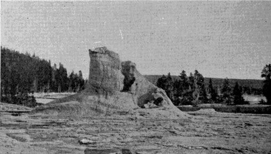
Terry Engr. Co.
U. S. Geological Survey of the Territories.
Cone of the Giant Geyser.
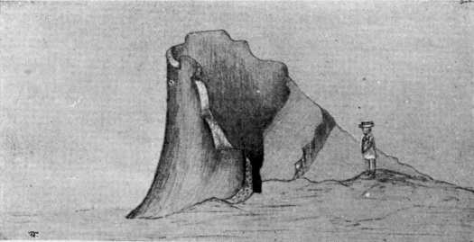
Terry Engr. Co.
First sketch ever made. [AU]—Trumbull.
Cone of Giant Geyser.
An interesting and singular fact pertaining to this region is that in most cases the springs and geysers have no underground connection with each other. Water in contiguous pools stands at different levels, and powerful geysers play with no apparent effect upon others near by.
It is another interesting question to know whence comes the water for these geysers and hot springs. Into the hidden caverns of “Old Faithful” flow nearly a million of gallons per hour. This is a large stream, but it is a mere trifle compared with the entire outflow of hot water throughout the Park. The subterranean passages by which the necessary supply is furnished to all these thousands of springs, certainly constitute the most intricate and extensive system of water-works of which there is any knowledge.
Not least wonderful of the features of the great geysers are the marvelous formations which surround them, more exquisitely beautiful than any production of art. They are really much handsomer than those to be found around the ordinary quiescent springs. The falling or the dashing of the hot water seems to be in some way essential to the finest results. To say that these rocky projections simulate cauliflower, sponge, fleeces of wool, flowers or bead-work, conveys but a feeble hint of their marvelous beauty. It is indeed a most interesting fact that nature here produces in stone, by the almost mechanical process of deposition from cooling water, the identical forms elsewhere produced by the very different processes of animal and vegetable life.
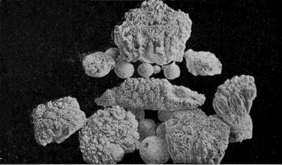
Terry Engr. Co.
U. S. Geological Survey of the Territories.
Specimens of Geyserite.
These formations are all silica and are of flinty hardness. Bunsen, and Prof. Le Conte following him, assert it to be a rule that the presence of silica in the water is essential to the development of a geyser. In one sense this is true, and in another it is not. Should the heated waters find a ready-made tube, like a fissure in solid rock, this would serve for a geyser tube as well as any other. The Monarch Geyser, in Norris Geyser Basin, seems to have originated in this way. But in the general case, geyser tubes are built up, not found ready made. In such cases silica is an indispensable ingredient of the water. A calcareous deposit, like that at Mammoth Hot Springs, would lack strength to resist the violent strain of an eruption. So it is found to be a fact that silica is the chief mineral ingredient in the water of all important geysers.
CHAPTER IV.
HOT SPRINGS.
Under this general head will be included all thermal phenomena of the Park, except the geysers. The term will cover the quiescent springs, the boiling springs, the mud springs, or “paint pots,” and the steam vents and fumaroles.
The quiescent spring seems to stand at the opposite pole from the geyser. The conditions are such that the water nowhere reaches a temperature sensibly above the boiling point. The surface therefore steams quietly away, unruffled except by the passing breeze.
The great attraction of these springs is in the inimitable coloring of the water. It is not simply the beautiful green or blue of great depths of clear water. In no ordinary pool can one find all the colors of the spectrum, flitting about, as though seen through a revolving prism. Sometimes there is an iridescent effect similar to that of a film of oil upon water; but there is no oil here. There are doubtless many contributing causes that produce these remarkable effects. There is first a great depth of clear water which always presents a beautiful appearance. Then there are the mineral deposits on the sides of the crater, producing indefinite reflection, the effects of which are multiplied by the refractive power of the water. The mineral ingredients dissolved or suspended in the water doubtless add to the effect.
The hot springs on the Gardiner River are wholly different in character from those in any other part of the Park. The water of these springs holds carbonate of lime in solution while most of the others contain silica. To this fact must be attributed the peculiar character of the formations at Mammoth Hot Springs. Wherever the deposits of springs are calcareous, the character of the formations is the same, and generally different from those produced by the deposit of silica. They rise in terraces one above another, and mold for themselves overhanging bowls of transcendent beauty in form and color. In the tints displayed by the water, however, these springs are not unlike others in the Park.
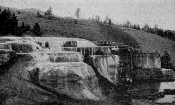
Terry Engr. Co.
Haynes, Photo., St. Paul.
Cleopatra Terrace.
The rims about the quiescent springs are often very beautiful, and the observer is astonished to see how they stand up above the general surface of the ground so evenly built that the water has hardly a choice of route in flowing away. Tyndall, however, makes this puzzling phenomenon clear. He says:
“Imagine the case of a simple thermal siliceous spring, whose waters trickle down a gentle incline; the water thus exposed evaporates speedily, and silica is deposited. This deposit gradually elevates the side over which the water passes, until finally the latter has to take another course. The same takes place here; the ground is elevated as before, and the spring has to move forward. Thus it is compelled to travel round and round, discharging its silica and deepening the shaft in which it dwells, until finally, in the course of ages, the simple spring has produced that wonderful apparatus which has so long puzzled and astonished both the traveler and the philosopher.”
The boiling spring is intermediate between the quiescent spring and the geyser. The circulation is sufficiently free to prevent a great rise of temperature in the lower depths of the tube, and nothing more than a surface ebullition, often extremely violent, results. These springs are generally objects of secondary interest. They are simply enormous caldrons; any kettle placed over a brisk fire simulates their action on a small scale.
The mud springs, or Paint Pots, as they are now always called, are extremely curious phenomena. They are caused by the rising of steam through considerable depths of earthy material. The water is just sufficient in quantity to keep the material in a plastic condition, and the steam operates upon it precisely as it does upon a kettle of thick mush. Generally there are various mineral ingredients, mostly oxides of iron, which impart different colors to different parts of the group. As the steam puffs up here and there from the thick mass, it forms the mud into a variety of imitative figures, prominent among which is that of the lily. These figures immediately sink back into the general mass, only to be formed anew by other puffs of steam. The material is so fine as to be almost impalpable between the fingers. Lieutenant Doane, however, justly observes that “mortar might well be good after being constantly worked for perhaps ten thousand years.”
Other phenomena very common throughout the Park are steam vents or fumaroles in which there is no water or only a very small quantity. They are not ordinarily of much popular interest, although there are a few remarkable examples. Among these may be mentioned the Black Growler in the Norris Geyser Basin, and Steamboat Spring on the east shore of the Yellowstone Lake.
The hot spring areas of the Park are both numerous and extensive. They abound throughout the valleys of the Yellowstone, the Madison, and the Snake Rivers, and the number of individual springs is several thousand.
CHAPTER V.
FOSSIL FORESTS OF THE YELLOWSTONE.
A region of great popular and scientific interest in the Yellowstone Park, although as yet hardly known to the tourist, owing to the incomplete condition of the road system, is that of the Fossil Forests in the north-east corner of the Park. The facts which have been brought to light concerning the origin of these forests are worthy of particular consideration.
The trees are found to occur in different planes or horizons of growth, one above another, until the whole series represents a thickness of many hundreds, and possibly thousands, of feet. Going back to the first of these growths, it is found to have been destroyed by an outpouring of volcanic material, which partially or wholly submerged it. After the flow had ceased, the ordinary atmospheric and aqueous agencies began work, eroding the surface in some places and depositing the products of erosion in others, while vegetation rapidly covered the newly-formed soil. A subsequent flow destroyed this second growth and gave a new horizon, on which the same process was repeated. This continued until there were at least nine, and probably twelve, of these consecutive growths.
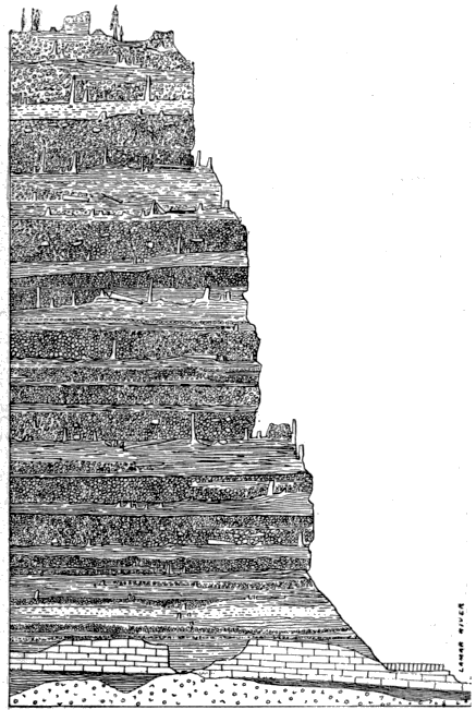
Terry Engr. Co.
U. S. Geological Survey of the Territories.
Section of Amethyst Mountains.
The lava flows in this particular section do not seem to have been characterized by great heat. They were composed of volcanic agglomerate, in which there was a large admixture of mud and water, with sufficient heat to destroy life, but not to char or consume its products. The percolation of siliceous waters gradually turned the arboreal vegetation into stone by the process of substitution, and thus preserved in these silent monuments a record of the events which once transpired there. When the last of the eruptions had ceased, there existed in this locality a vast depth of volcanic ejectamenta, composed of many layers, on each of which was standing, buried in the layer next above, the trunks of extinct forest growths.
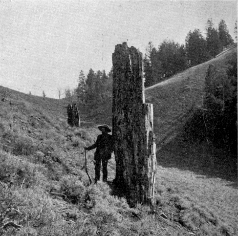
Terry Engr. Co.
Haynes, Photo., St. Paul.
Petrified Trees near Yancey's.
After the cessation of volcanic activity, the eroding agencies of the Quaternary Period carved out the valley of the Lamar River through these accumulated flows, and laid bare the remains of their vegetable growths. To-day the tourist may see upon the slopes of Specimen Ridge, side by side, the living and the dead, the little conifers of present growth and the gigantic trunks of unknown species which flourished there eons ago.
Some of the petrifactions are very perfect. Roots, bark, parts showing incipient decay, worm holes, leaves—all are preserved with absolute fidelity. The rings of annual growth may be counted, and these indicate for the larger trees an age of not less than five hundred years. Some of the stumps are fully ten feet in diameter. Here and there the ponderous roots stand imbedded in the rock face of the cliff, where erosion has not yet undermined them. In one case, a large tree that had fallen before petrifaction lies partly exposed, both ends being still imbedded in the rock. Some hollow trees show interiors beautifully lined with holocrystalline quartz.
How long it took each growth to reach maturity; how long it flourished afterward before destruction; and how long the several lava flows suspended vegetable growth; are matters largely conjectural. But at the very lowest estimate the time represented by these various accumulations can not be less than five thousand years.
That these early trees were of a different species from those which now flourish there, need not excite surprise, for climatic and other conditions are wholly changed. But an equal difference seems also to have prevailed between the successive growths, the trees of which were not only unlike each other, but nearly all were of species hitherto unknown to science. Fortunately the rare perfection of some of the specimens, particularly of the leaves and bark, have greatly simplified their classification, and have given valuable clues to their geologic age.
The products of these petrifactions in time strewed the surface of the ground with such an abundance of specimens as to give the locality its present name. Most of the lighter specimens, and some of the heavier, have been carried away.
Besides the general interest of these old forests to the casual observer, they are of great value to science, for probably in no other part of the globe can a similar chapter of its history be found more clearly recorded.
CHAPTER VI.
FAUNA OF THE YELLOWSTONE.
The universal curiosity of people to see what are popularly called wild animals, especially those larger species which never frequent the precincts of civilization, is a fact of which it is not easy to give a philosophical explanation. In this country the rapid disappearance, amounting almost to annihilation, of the large game is looked upon as a great misfortune; and in later years there has arisen a fixed purpose that protection shall be secured for the surviving remnants of those species which once with the red man held possession of the continent. The statutes of nearly every state give evidence of the universality of this sentiment.
As a means of accomplishing such a purpose, no institution promises to be more effectual than the Yellowstone Park. It ought, in this respect, to be a complete realization of Catlin’s dream. Its importance as a game preserve was recognized in the Act of Dedication, and has become more and more pronounced as acquaintance with it has increased.
The Park is fortunately better adapted for this purpose than any other tract of similar extent in America. It offers very little to tempt the cupidity of man. Its mineral wealth is buried so deeply under the lava that no miner will ever reach it. Its altitude and climate unfit it for agriculture. Its forests, though excellent for shade, are of little value for lumber. But as a home for the native species of the continent, it possesses unrivaled advantages. These are admirably summed up in the following paragraph from the pen of Prof. Hague:
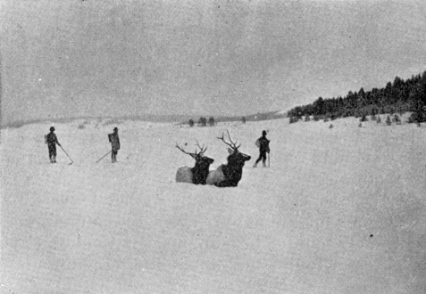
Terry Engr. Co.
Haynes, Photo., St. Paul.
Park Elk.
"The broad expanse of forest incloses sequestered nooks, and enticing grassy parks, with absolute seclusion in mountain recesses admirably adapted for the homes of wild animals. It is the great diversity of its physical features, offering within a restricted area. all the requirements for animal life, which fits it for the home of big game. Abundant food supply, shelter from wind and weather in winter, cool resorts on the uplands in summer, favorable localities for breeding purposes and the rearing of young, all are found here. The Park supplies what is really needed—a zoological reservation where big game may roam unmolested by the intrusion of man, rather than a zoological garden inclosed by fences, and the game fed or sustained more or less by artificial methods." [AV]
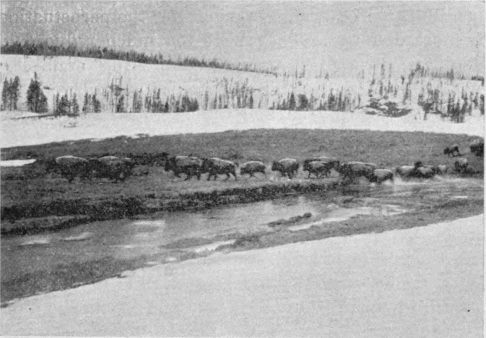
Terry Engr. Co.
Haynes, Photo., St. Paul.
Park Buffalo.
It is a matter of profound regret that the many years of lax administration in the Park to a great degree nullified its purposes as a game preserve. Killing of wild animals was not absolutely prohibited until 1883, and the restricted license previously in force was shamefully abused. Some of the larger species were greatly reduced in numbers, while in a few instances they were practically exterminated. In later years, the elk, antelope, deer, bear and beaver, have rapidly regained their former numbers, and there is no reason to apprehend their extinction. There are now no fewer than 30,000 elk in the Park. For the buffalo, mountain sheep, and a few other varieties, the prospect is good, though not so flattering. The number of buffalo does not probably exceed two hundred, and the possibility of their early extinction has led the Smithsonian Institution to allot a sum of money for the construction of a large inclosure in the Park, where at least a portion of the herd can be kept and be thus more carefully protected. Of the moose, mountain lion, wolverine, lynx, wild cat, marten, and otter the perpetuation is more doubtful. They were too much reduced in numbers during the game slaughtering era. The smaller species, such as porcupines, foxes, gophers, squirrels, woodchucks, and the like, flourish in great numbers.
The tourist often feels a keen disappointment in passing through the Park in that he does not see more game, and he not infrequently expresses positive doubts of its existence. He should remember, however, that it is the nature of wild game to shun the haunts of man. If he will remain for some time in the Park and will frequent those regions remote from the tourists routes he will see game in plenty. In one important instance he rarely goes away disappointed. Bruin generally accommodates him. The fine instincts of that intelligent brute have shown him that it is much easier to get a living from the refuse about the hotels than to forage for it in the wilds of parsimonious nature. Nightfall, therefore, always brings him about to the great delight of the game-seeking tourist. The incidents of each season to which these bears unwittingly give rise are among the amusing features of tourist life in that region.
The herbivorous game generally seek the seclusion of the hills in summer, but the deep snows of winter will not permit them to remain there. At that season they descend to the valleys, of which the most important are the Hayden, the Junction, and the Pelican Valleys, and those about the headwaters of the Snake River. The preservation of these tracts as a free winter pasturage is absolutely essential to the perpetuity of game in the Yellowstone Park.
Although an ornithologist, in passing through the Park, would report a list of native birds so extensive as to lead one to think that they abound in great numbers, there is really a noticeable absence of the winged tribes. There are birds, of course, but in numbers, variety, and beauty not to be compared with those in lower altitudes. The only varieties that would attract attention from any but specialists are the larger birds, which are often quite plentiful about the lakes. There are great numbers of pelicans, gulls, fish-hawks, and cranes, with now and then a wild swan. Eagles are not uncommon, while hawks, woodpeckers, and robins are frequently seen. The sharp-tailed or willow grouse is common, and in the fall of the year astonishing numbers of wild geese and ducks frequent the marshes. There are many other varieties, conspicuous mainly for their paucity of numbers.
Piscatorially speaking, the Yellowstone National Park has no rival as a paradise for the angler. The generous gift of nature and the admirable work of the United States Fish Commission, supplemented by the wise protection of the government, leave nothing to be desired by even the most devout follower of Isaak Walton.
Not all the streams of the Park were originally stocked with fish. Where the waters leave the great volcanic plateau and fall to the underlying formations, the cataracts form impassable barriers to the ascent of fish. In the lower courses of all the streams there were native trout, but above the falls, with one exception, there were none. The exception of the Yellowstone River and Lake is a most interesting one. Why the Falls of the Yellowstone, the highest and most impassable of all, should apparently have proven no barrier, is at first a puzzling question. But the solution is to be found in Two-Ocean Pass. Across this remarkable divide fish may easily make their way, and the Yellowstone Lake is unquestionably stocked from this direction. We thus have an example, probably without parallel, of an extensive body of water on the Atlantic slope stocked by nature with fish from the Pacific.
The trout of the Yellowstone Lake are to some extent infected with a disease which renders them unfit for eating. In earlier times particularly, this condition was generally prevalent. But more recently the disease seems to be disappearing, and in time it will probably die out altogether.
In 1889 and 1890, the United States Fish Commission undertook to stock all the fishless streams in the Park, and planted about 83,000 yearling trout in the various streams and lakes. The varieties were Brook, Lake, Loch Leven, and Von Behr trout. Recent examination of these plants shows that all have taken decisive root, and that within a few years there will not be a hidden stream or lake in the Park which will be without its attractions for the sportsman.
CHAPTER VII.
FLORA OF THE YELLOWSTONE.
The most conspicuous feature of the Park flora is the wide extent of forest growth which covers some eighty-four per cent of its area. This is the more noticeable because the surrounding country below the mountains is practically treeless. The Park forests consist almost exclusively of pine and fir. The trees are generally tall and slender and of little use for lumber. They are usually unattractive in appearance, although in some places among the mountains the spruce and fir attain a size, form and hue of foliage that are exceedingly beautiful.
Among the several species may be noted the following:
Black pine (Pinus Murrayana) so called from the dark hue of its foliage when seen in dense bodies.
Red fir (Pseudotsuga Douglasii) the largest variety in the Park, sometimes attaining a diameter of five feet.
Balsam (Abies subalpina). It flourishes near the snow fields and is the beauty of the forest.
Spruce (Pinus Engelmanni). Like the preceding it flourishes at high altitudes. It is tall and slender, and is good for lumber.
Red cedar (Juniperus virginiana) is found to a limited extent.
Poplar or aspen (Populus tremuloides) flourishes among the sheltered foot-hills.
Dwarf maple is occasionally found.
Willow thickets abound in great abundance.
Of these varieties the first is found more abundantly than all the others combined. In many places it has fallen down and strews the country to such an extent as to be absolutely impassable on horseback. There is very little timber of marketable value, and at first thought it would seem that nature has here lavished her energies in a most wasteful manner.
But the great value of these forest growths, is their agency in the conservation of a water supply for the surrounding country. A glance at the map will show that the Park is in the midst of a vast arid region extending far into the surrounding states. The reclamation of these desert wastes, and their conversion into productive lands, can be accomplished by irrigation alone, and for this purpose the abundant streams which descend from the mountains are the indispensable water supply.
From the summit of the Grand Teton, the range of vision covers probably the most remarkable group of river sources upon the earth. To the north rises the Missouri which flows three thousand miles through Montana, the Dakotas, Iowa, Nebraska, Kansas and Missouri. To the east rises the Yellowstone, which, after leaving the Park, flows four hundred miles through southern and eastern Montana until it unites with the Missouri. From the eastern foot-hills of the Absaroka and Shoshone Ranges flow the Wind and Big Horn Rivers through the extensive valleys of the same names in Wyoming and Montana. Southwardly, across the Wind River Range rises the Platte which flows eastward eight hundred miles through Wyoming and Nebraska. From the west flank of these mountains issue the tributaries of the Green River (afterward the Colorado) which flows through Wyoming, Utah and Arizona into the Gulf of California. Finally, interlaced with the sources of the Yellowstone, and the Missouri, are those of the Snake River which flows through Wyoming, Idaho and Washington into the Columbia, and thus reaches the Pacific.
Not only do these streams rise in this limited area; they derive from it most of their waters. In the arid lowlands they receive but slight accessions, and often actually shrink under evaporation. It is therefore from a relatively small tract of country that the future water supply must come for portions of ten states in the great arid belt of the west.
The conditions which nature has established around this remarkable fountain-head are admirably adapted for the creation and maintenance of an unlimited water supply. Over an area of more than 5,000 square miles there prevails an average altitude of perhaps 7,500 feet; sufficient to insure enormous annual snowfalls, but not so great as to prevent their complete melting in summer. But, that they may not melt too rapidly, the whole region is covered with a thick forest growth cutting off the intense rays of the summer sun, and covering the ground with a vegetable mold through which the surface waters filter but slowly. It is a conservative estimate, based upon observations in connection with road work in the Park, that these forests prolong the melting of the snows from four to six weeks. This condition greatly lessens the liability to sudden floods, and maintains a generous supply of water far into the summer.
It has been estimated [AW] that from the Park alone, at low water, there flows per second 4,000 cubic feet of water. If the time ever comes when this supply is so far used as to threaten exhaustion, there will be found in the basin of Yellowstone Lake the most perfect facilities in the world for the construction of an artificial reservoir of almost limitless capacity at a comparatively insignificant cost. A dam could be thrown across the gorge at the first rapids in the Yellowstone below the Lake, and without injuring the natural condition of that region, could easily be made to quadruple the present capacity of the Lake.
The Park with its contiguous area thus presents magnificent possibilities in the development of the surrounding country—possibilities of which its founders little dreamed, but which they unconsciously foreshadowed when they declared that this region should be forever set apart for the “benefit” as well as for the “enjoyment” of the people.
Besides its wealth of trees, the Park produces other interesting flora. Interspersed among the forests and ornamenting the open glades are flowers and shrubs in endless profusion. We quote from the description of one of the early visitors:
"The choke-cherry, the goose-berry, the buffalo-berry, and black and red currants, are found along the streams and in moist places of the middle and lower altitudes. The meadows and hill-sides are spangled with bright-colored flowers, among which may be noted the bee-larkspur, the columbine, the harebell, the lupine, the evening primrose, the aster, the painted cup, the gentian, and various kinds of euphorbia. It is not uncommon to find daises, buttercups, forget-me-nots, white-ground phlox, and other field flowers flourishing in profusion near the melting snow banks during the month of August. Scarcely a night throughout the year passes without frost, even though the temperature by day is over 80 F., so that all forms of vegetation in the Park grow and bloom under somewhat unusual conditions. Indeed, when ice forms in the water-pails of camping parties during the night, as often happens, and the petals of the flowers become crisp with frost; even then the blooms are not harmed, but thaw out bright and fresh when the hot sun touches them."
The flowers form a most attractive feature of the Park, and give an interesting study of the way in which altitude and temperature affect well known varieties. It is only after a second look that one can trace in the mountain dandelion, huckleberry, and other species a resemblance to those of lower altitudes. The extreme shortness of the season causes vegetation to mature quickly, and before the flush of spring has disappeared from the leaves the palor of autumn makes its appearance.