Front matter (continued 2)
Reading edition
The two parties separated May 24th. Captain Raynolds, according to his programme, kept up the Wind River valley, and with much difficulty effected a crossing by way of Union Pass—which he named—to the western slope of the mountains. He then turned north seeking a passage to the head waters of the Yellowstone. When nearly opposite Two-Ocean Pass, he made a strenuous effort to force his way through, spending two days in the attempt. But it was still June and the snow lay deep on the mountains. It was a physical impossibility to get through at that point, and the risk of missing the eclipse forebade efforts elsewhere. The Captain was deeply disappointed at this result. He writes:
“My fondly cherished schemes of this nature were all dissipated by the prospect before us; … and I therefore very reluctantly decided to abandon the plan to which I had so steadily clung.”
It seems not a little singular that so experienced a guide as Bridger should not have conducted the party up the valley of the Snake River and thence over the low divide between that stream and the Yellowstone Lake—a route which was perfectly practicable even as early as June. But the plan does not appear to have been entertained, and the expedition passed around the Park region to the west, arriving at the Three Forks on the 29th of June.
Lieutenant Maynadier wisely made no attempt to cross the Absaroka Range, which rose continuously on his left. Had he done so, the deep snow at that season would have rendered his efforts futile. He kept close to the flank of the mountains until he reached the valley of the Yellowstone north of the Park, and then hastened to join his commanding officer at the appointed rendezvous. He reached the Three Forks on the 3d day of July.
The expedition had now completely encircled the region of the Upper Yellowstone. At one point Captain Raynolds had stood where his eye could range over all that country which has since become so famous; but this was the limit of his endeavor. The Yellowstone wonderland was spared the misfortune of being discovered at so early a day—a fact quite as fortunate as any in its history.
It will be interesting now to survey this region as known at the time of the Raynolds Expedition. Nothing of importance occurred to increase public knowledge of it until 1870, and Captain Raynolds' [W] Report is therefore the latest authentic utterance concerning it prior to the date of actual discovery. In this report Captain Raynolds says:
"Beyond these [the mountains south-east of the Park], is the valley of the Upper Yellowstone, which is as yet a terra incognita. My expedition passed entirely around, but could not penetrate it…. Although it was June, the immense body of snow baffled all our exertions, and we were compelled to content ourselves with listening to marvelous tales of burning plains, immense lakes, and boiling springs, without being able to verify these wonders. I know of but two men who claim to have ever visited this part of the Yellowstone Valley—James Bridger and Robert Meldrum. The narratives of both these men are very remarkable, and Bridger, in one of his recitals, described an immense boiling spring, that is a perfect counterpart of the geysers of Iceland. As he is uneducated, and had probably never heard of the existence of such natural wonders elsewhere, I have little doubt that he spoke of that which he had actually seen…. Bridger also insisted that immediately west [X] of the point at which we made our final effort to penetrate this singular valley, there is a stream of considerable size, which divides and flows down either side of the water-shed, thus discharging its waters into both the Atlantic and Pacific Oceans."
The Captain concludes this particular part of his report as follows:
“I can not doubt, therefore, that at no very distant day, the mysteries of this region will be fully revealed; and, although small in extent, I regard the valley of the Upper Yellowstone as the most interesting unexplored district in our widely expanded country.”
Lieutenant Maynadier also contributes a few interesting observations upon this region. The vast importance of that extensive mass of mountains, as a reservoir of waters for the country round about, impressed him deeply. He says, somewhat ostentatiously:
“As my fancy warmed with the wealth of desolation before me, I found something to admire in the calm self-denial with which this region, content with barren magnificence, gives up its water and soil to more favored countries.”
Of the Yellowstone River, he was told that it had its source “in a lake in the impenetrable fastnesses of the Rocky Mountains;” and that for some distance below the lake it flowed through a narrow gorge, up which “no one has ever been able to travel.”
Opp. page 62.
Click on image to view larger size.
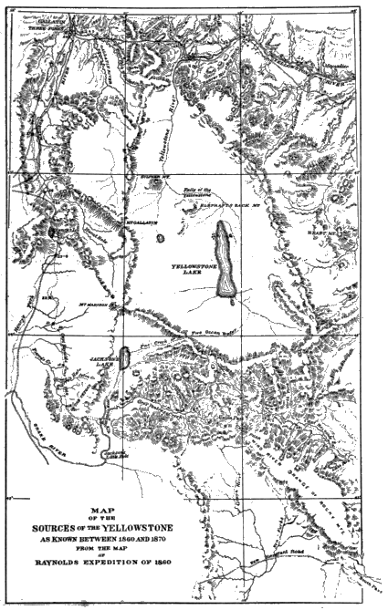
But it is the map prepared by Captain Raynolds that tells a more interesting story even than his written report. It reveals at once to the eye what was known as well as what was unknown of the Upper Yellowstone. Extending in a south-easterly and north-westerly direction, is a large elliptical space, within which geographical features are represented by dotted lines, indicating that they are put in by hearsay only. In the midst of a surrounding country, which is already mapped with great accuracy, there is a region wholly unknown to the geographer. A cordon of mountains encircles it, and shows the limit of official effort to gain a correct knowledge of it. Within this enchanted inclosure lies the region approximately defined by the 44th and 45th parallels of latitude and the 110th and 111th meridians of longitude, which now constitutes the Yellowstone National Park. There one may catch glimpses, through the uncertain haze of tradition, of the geysers, hot springs, Lake, Falls, Grand Cañon, Mammoth Hot Springs, and Two-Ocean Pass. This was the net result of fifty years' desultory wandering in and about and over this “mystic” region.
Raynolds' report, it must be remembered, was the first official recognition in any form of the probable existence of extensive volcanic phenomena in the region of the Upper Yellowstone. Had it been published immediately after the expedition, and had not public attention been totally engrossed with other matters of overshadowing importance, this region must have become fully known in the early Sixties. But within a month after the return of Captain Raynolds to civilization there had taken place the national election which was the signal for attempted armed disruption of the Union. A year later found every officer of the Army called to new fields of duty. Western exploration entirely ceased until 1865, and was not vigorously resumed for some years thereafter. Captain Raynolds' report did not appear until 1868, although his map was published several years earlier in order to meet a demand for it by the new settlers in western Montana, Nothing transpired in the meantime to make the general public familiar with this region, and the picture here given is therefore substantially correct down to the date of the celebrated Washburn expedition.
CHAPTER VIII.
GOLD IN MONTANA.
Perhaps the most fascinating pages of American history are those which recount the annals of the discoveries of gold and silver. No one can appreciate the magnitude of those various movements by a simple perusal of statistics of the mineral wealth which they disclosed. He must pass through the mining belts and note how almost every rod of ground, over vast tracts of country, is filled with prospect holes that attest the miner’s former presence. If the trapper carried the tools of his trade to haunts remote and inaccessible, the miner, with his pick and shovel, certainly outdid him. One can readily understand that, as soon as such a movement should be directed toward the region of the Upper Yellowstone, the wonders of that region would speedily be revealed.
The presence of gold in the mountains of Montana was first noticed as far back as 1852. Later, in 1858, the Stuart brothers, James and Granville, founders of Montana, discovered gold in the Deer Lodge Valley; but they were destitute of equipments, and so constantly exposed to the hostility of the Blackfeet, that they went to Fort Bridger in the south-west corner of Wyoming, and did not return until late in 1860.
It was in 1860 and 1861 that the rich mines on the Salmon and Boisé rivers were discovered. In 1862 the tide of discovery swept across the mountains into Montana. The rich mines on Pioneer Creek, the Big Prickly Pear, the Big Hole River, North Boulder Creek, and at Bannock and other points, became known. Although there were scarcely a thousand people in Montana in the winter of 1862-3, the news of the great discoveries marshaled a host of immigrants ready to enter the territory in the following spring. These were largely re-enforced by adventurers from both the northern and southern states, who, with little credit to their courage or patriotism, sought in these remote regions exemption from the tributes and levies of war. The immigrants were welcomed in the spring of 1863 by the news of the discovery of Alder Gulch, the richest of all gold placers. The work of prospecting, already being pushed with vigor, was stimulated to an extraordinary degree by this magnificent discovery. Prospecting parties scoured the country in all directions, often with loss of life through the Indians, but rarely, after the first two or three years, with any substantial success. Some of these expeditions have a particular connection with our narrative because they passed across portions of what is now the Yellowstone Park.
The most important of them occurred in August and September, 1863. It was led by Walter W. DeLacy, an engineer and surveyor of some distinction in the early history of Montana. The party at one time numbered forty-two men, although this number did not continue constant throughout the expedition. Its sole object was to “prospect” the country. Evidently nothing in the line of topographical reconnaissance was thought of, for Captain DeLacy says “there was not a telescope, and hardly a watch, in the whole party.”
The expedition left Virginia City, August 3d; passed south into Idaho until it struck the Snake River, and then ascended that stream to the region about Jackson Lake. Near the mouth of Buffalo Fork a halt was made, a corral was built to hold the stock, and a miners' meeting held at which rules were adopted to govern the miners in the contemplated examination of the country. The party then broke up into small groups and set out in different directions so as to cover as much ground as possible. The last four days of August were spent in this search, but with failure in every direction. This discouragement led to the abandonment of the expedition. Fifteen men set out for home by the way they had come, while DeLacy and twenty-seven men resolved to reach the Madison River and the settlements by going north. A day later this party entered the territory which is now the Yellowstone Park.
The route lay up the Snake River to its junction with Lewis River where the hot springs of that locality were discovered. Here another separation occurred. About half the party went back down the river to re-examine a locality where they thought they had found some fair prospects. They soon returned, however, unsuccessful. The main party under DeLacy ascended the hills to the west of the river to seek a more practicable route. They soon reached the summit of the plateau where they discovered what are now Hering and Beula lakes, and noted their divergent drainage. Thence they passed north over Pitchstone Plateau until they struck the valley of Moose Creek. They descended this stream for a few miles and came to a large lake, which they supposed to be tributary to either the Madison or the Yellowstone Rivers. To their great surprise they found, upon rounding its southern point, that it drained south into the Snake. This is what is now called Shoshone Lake.
From the outlet of the lake, DeLacy sent a man down stream to examine the river. This reconnaissance resulted in the discovery of Lewis Lake and the hot springs basin there. When DeLacy resumed his route, he followed along the east shore of the lake to its northern extremity, and then ascended the beautiful open valley of DeLacy Creek. He crossed the Continental Divide at the head of the valley, and camped on the evening of September 8th some miles beyond the Divide toward the Firehole River. The next morning, September 9, 1863, he came upon the considerable stream of hot water which flows down a mountain ravine into the Lower Geyser Basin close by the Great Fountain Geyser. The reader will learn with some amazement that our party thought little enough of this wonderful locality to pass directly through it without halt or perceptible delay. Before the camping hour of the afternoon had arrived, they were many miles away at the junction of the Gibbon and Firehole rivers.
The other section of the party, which had gone down the Snake from its junction with Lewis River, soon returned, followed up the river to Lewis and Shoshone lakes, passed around the western end of the latter lake discovering its extensive geyser basin, and thence crossed over to the Madison. This stream they descended through the geyser basins, and followed the main party to the settlements.
DeLacy might have passed into history as the real discoverer of the Yellowstone wonderland, but for the fact that he failed to appreciate the true importance of what he saw. In that, however, he was no exception to the general rule of immigrants. The search for gold with them so far overshadowed all other matters, that it would have required something more than geysers to divert them, even momentarily, from its prosecution. Although DeLacy kept a daily journal of his expedition, and noted therein the various items of interest along his route, he did not publish it until 1876, long after public interest had been strongly attracted to the geyser regions. He did, however, publish a map of the country through which he passed, and on this map he correctly noted the drainage of Shoshone Lake—something which the Folsom, Washburn, and Hayden (1871), expeditions all failed to do. He also noted the various hot springs localities through which the party passed. In a letter published in Raymond’s “Mineral Resources of the States and Territories West of the Rocky Mountains,” in 1869, before the date of the Washburn Expedition, he called attention to the existence of geysers at the head of Shoshone Lake and on the Madison River.
DeLacy’s account, as finally published, is an interesting early view of this region, and is remarkable for its general correctness. That he failed to publish his discoveries must be regarded as fortunate so far as the Park is concerned, for the time had not yet come when it was desirable that the real character of this country should be made known.
From 1863 to 1869 there were many other prospecting parties in the region of the Upper Yellowstone. In 1863 one of these parties, numbering thirty or forty men, ascended the Yellowstone and the East Fork to the mouth of Soda Butte Creek, and thence crossed an intervening ridge to the next northern tributary of the East Fork. Here all their horses were stolen by Indians. There were left only one or two mules on which was packed all the baggage they could carry, the rest being concealed in a cache. The party then separated into two portions and prospected the country for several days in the vicinity of Clark’s Fork. They finally returned, emptied the cache, and descended to the Yellowstone where they found fair prospects near the present north boundary of the Park. The expedition has no permanent interest for this narrative except that it left the two geographical names, “Cache Creek” and “Bear Gulch.”
In 1864, a party of seventy-three men under James Stuart passed from Deer Lodge, Montana, to the Yellowstone Valley, and thence around the east base of the Absaroka Range into the valley of the Stinkingwater. The object of this expedition was to punish the Indians for outrages of the previous year, and also to prospect the country for gold. At the Stinkingwater, Stuart was compelled to return home. The party then separated into groups that gradually worked their way back to the Montana settlements. One of these small parties went as far south as the Sweetwater River, then crossed to the Green and Snake Rivers, and re-crossed the Continental Divide at Two-Ocean Pass. They descended the Yellowstone, past the Lake and Grand Cañon, and beyond the present limits of the Park. Norris found remnants of their camp debris seventeen years afterward.
In 1866, a party under one George Huston left Virginia City, Montana, and ascended the Madison River to the geyser basins. Thence they crossed to the Yellowstone at Mud Geyser, ascended the river to the lake, passed completely around the latter, discovering Hart Lake on their way, and then descended the Yellowstone by the Falls and Cañon, to Emigrant Gulch. Here they were interviewed by a newspaper reporter, and an account of their travels was published in the Omaha Herald. They had seen about all there was to be seen in the whole region.
At least two parties traversed the Park country in 1867. One of these gave names to Crevice, Hell-roaring and Slough Creeks. An account of the wanderings of the other party appeared in the Montana Post of that year.
Many other parties and individuals passed through this region during the Montana mining craze. Their accounts appeared now and then in the local papers, and were reprinted throughout the country. By 1869, probably very few of the reading public had not heard rumors of a strange volcanic region in the Far West. In Montana, particularly, repeated confirmation of the old trappers' tales was gradually arousing a deep interest, and the time was fast approaching when explorations for the specific purpose of verifying these rumors were to begin.
CHAPTER IX.
DISCOVERY.
The discovery of the Yellowstone Wonderland—by which is here meant its full and final disclosure to the world—was the work of three parties who visited and explored it in the years 1869, 1870, and 1871, respectively. The first of these expeditions was purely a private enterprise. It consisted of three men, and was the first party to enter this country with the express purpose of verifying or refuting the floating rumors concerning it. The second expedition was of a mixed character, having semi-official sanction, but being organized and recruited by private individuals. This was the famous “Yellowstone Expedition of 1870”—the great starting point in the post-traditional history of the Park. The third expedition was strictly official, under the military and scientific departments of the government. It was a direct result of the explorations of 1870, and was intended to satisfy the public demand for accurate and official information concerning this new region of wonders. It was the final and necessary step in order that the government might act intelligently and promptly for the preservation of what was believed to be the most interesting collection of wonders to be found in the world. [Y]
THE EXPEDITION OF 1869.
The question of setting definitely at rest the constantly multiplying rumors of wonderful volcanic phenomena around the sources of the Yellowstone, began to be seriously agitated among the people of Montana as early as 1867. An expedition was planned for that year but came to nothing. A like result attended a similar effort the following year. In 1869, the proposition came near materializing, but fell through at the last moment owing to the failure to obtain a military escort. There were three members of this proposed expedition, however, who refused to be frightened off by any dangers which the situation at that time promised. They had already provided themselves with an elaborate equipment, and were determined, with escort or without it, to undertake the trip. The names of these men were David E. Folsom, C. W. Cook, and William Peterson, the last named being a native of Denmark. Armed with “repeating rifles, Colt’s six-shooters, and sheath-knives,” with a “double-barreled shot gun for small game;” and equipped with a “good field-glass, pocket compass and thermometer,” and utensils and provisions “for a six weeks' trip,” they set out from Diamond City on the Missouri River, forty miles from Helena, September 6, 1869.
The route lay up the Missouri to the Three Forks; thence via Bozeman and Fort Ellis to the Yellowstone River; and thence up the Yellowstone to its junction with the East Fork inside the present limits of the Park. From this point they crossed to the east bank and followed up the river, passing through the many groups of hot springs to be found east of the Grand Cañon. On September 21st, they arrived at the Falls of the Yellowstone, where they remained an entire day. Some distance above the rapids they re-crossed to the west shore and then ascended the river past Sulphur Mountain and Mud Volcano to Yellowstone Lake. They then went to the extreme west shore of the lake and spent some time examining the surpassingly beautiful springs at that point. Thence they crossed the mountains to Shoshone Lake, which they took to be the head of the Madison, and from that point struck out to the north-west over a toilsome country until they reached the Lower Geyser Basin near Nez Percé Creek. Here they saw the Fountain Geyser in action and the many other phenomena in that locality. They ascended the Firehole River to Excelsior Geyser and Prismatic Lake, and then turned down the river on their way home. They were absent on the expedition thirty-six days.
It is said that these explorers were so astonished at the marvels they had seen that “they were, on their return, unwilling to risk their reputations for veracity by a full recital of them to a small company whom their friends had assembled to hear the account of their explorations.” But Mr. Folsom later prepared a most entertaining narrative of his journey which was published in the Western Monthly, of Chicago, in July, 1871. [Z] This article deserves a high rank in the literature of the Park. It is free from exaggeration and contains some descriptions unsurpassed by any subsequent writer. The article, and personal interviews with the author and his companions, had a strong influence in leading to the important expedition next to be described.
THE EXPEDITION OF 1870.
The Yellowstone Expedition of 1870, more commonly known as the Washburn-Doane Expedition, was the culmination of the project of discovery to which frequent reference has already been made. At this time the subject was exciting a profound interest throughout Montana, and the leading citizens of the territory were active in organizing a grand expedition. General Sheridan, who passed through Helena just prior to his departure for the scene of the Franco-German War, spent some time in arranging for a military escort to accompany the party. The project did not assume definite shape until about the middle of August, and when the time for departure arrived, Indian alarms caused a majority of the party to repent their decision to join it. Finally, their were only nine persons who were willing to brave all dangers for the success of the undertaking. These nine were:
General Henry D. Washburn, Surveyor-General of Montana, chief of the expedition, and author of a series of valuable “notes” describing it. [AA]
Hon. Nathaniel P. Langford, who published a series of articles in Scribner’s Magazine, [AB] which gave general publicity to the news of discovery. He became first Superintendent of the Park.
Hon. Cornelius Hedges, who first proposed setting apart this region as a National Park.
Hon. Truman C. Everts, ex-U. S. Assessor for Montana, whose experience upon the expedition forms the most painful and thrilling chapter in the annals of the Yellowstone.
Hon. Samuel T. Hauser, President of the First National Bank of Helena, and later Governor of Montana.
Walter Trumbull, son of the late Senator Trumbull. He published an account of the expedition in the Overland Monthly for June, 1871. [AC]
Other civilian members of the expedition were Benjamin Stickney, Jr., Warren C. Gillette, and Jacob Smith.
The personnel of this party is sufficient evidence of the wide-spread interest which was being taken at the time in the region of the Upper Yellowstone.
The party proceeded from Helena to Fort Ellis, one hundred and twenty-five miles, where they were to receive a military escort promised by General Hancock, at that time commanding the department in which Fort Ellis was located. The post order detailing this escort is dated August 21, 1870, and directs Lieutenant Gustavus C. Doane, Second Cavalry, with one sergeant and four privates, “to escort the Surveyor-General of Montana to the falls and lakes of the Yellowstone and return.” There is a significant absence in this order of any reference to geysers or hot springs; and the discreet post commander evidently did not intend to commit himself to a recognition of their existence on the strength of such knowledge as was then available. His incredulity was indeed largely shared by the members of the party themselves. Mr. Hedges subsequently said:
“I think a more confirmed set of sceptics never went out into the wilderness than those who composed our party, and never was a party more completely surprised and captivated with the wonders of nature.”
Lieutenant Doane, than whom no member of the expedition holds a more honorable place in its history, has left on record a similar confession.
The party as finally organized, including two packers and two colored cooks, numbered nineteen individuals. Thirty-five horses and mules, thoroughly equipped for a month’s absence, completed the “outfit,” and made altogether quite an imposing cavalcade.
August 22, 1870, the expedition left Fort Ellis, crossed to the Yellowstone, and ascended that stream through the First and Second Cañons, past the “Devil’s Slide” and Cinnabar Mountain, to the present north boundary line of the Park at the mouth of the Gardiner River. At this point they were within five miles of the celebrated Mammoth Hot Springs which are now the first attraction to meet the tourist’s eye on entering the Park. But the party kept close to the Yellowstone, instead of taking the modern route up the Gardiner, and missed this wonder altogether.
It was August 26th when the expedition entered the present territory of the Park. Lieutenant Doane and Mr. Everts, with one soldier and two hunters picked up on the way, rode in advance along the brink of the Third Cañon and across the high plateau between the Gardiner and Tower Creek, camping at nightfall upon the latter stream. In the broad open valley near the junction of the Yellowstone and East Fork, a small tepid sulphur spring gave them the first evidence of their approach to the regions of volcanic activity.
Next day, the remainder of the party arrived. Two days were spent in examining the beautiful Tower Falls, and—to our tyros in geyser exploration—the wonderful hot spring formations to be seen at that point. Here they also had for the first time glimpses of the Grand Cañon of the Yellowstone.
The party left Tower Creek on the 29th of August, and followed up the river over the east flank of Mount Washburn. As their progress lifted them rapidly above the surrounding country, a marvelously beautiful landscape unfolded itself to their view. Presently an interesting incident occurred, which shall stand here in Lieutenant Doane’s own language:
"Through the mountain gap formed by the cañon, and on the interior slopes some twenty [evidently a misprint] miles distant, an object now appeared which drew a simultaneous expression of wonder from every one of the party. A column of steam, rising from the dense woods to the height of several hundred feet, became distinctly visible. We had all heard fabulous stories of this region, and were somewhat skeptical of appearances. At first it was pronounced a fire in the woods, but presently some one noticed that the vapor rose in regular puffs, as if expelled with great force. Then conviction was forced upon us. It was indeed a great column of steam, puffing away on the lofty mountain side, escaping with a roaring sound audible at a long distance, even through the heavy forest. A hearty cheer rang out at this discovery, and we pressed onward with renewed enthusiasm."
The party then ascended the lofty mountain to their right, now known as Mt. Washburn, and from its summit looked around upon the vast panorama which is now included in the Yellowstone National Park. Had old James Bridger been present at that moment, he would have received ample vindication for long-standing injustice at the hands of his incredulous countrymen. There were the Cañon and Falls and Lake of the Yellowstone, with evidence enough of boiling springs and geysers! The enthusiasm of the party was unbounded, and Lieutenant Doane exultingly declares that they were “more than satisfied with the opening up of the campaign.”
The pack-train continued its course along the side of the mountain, and went into camp after a march of only twelve miles. That evening, Messrs. Washburn, Doane, and Hedges went on ahead of the main party, discovering the extensive mud springs at the southern base of the mountain, and finally reached the verge of a cliff beyond which yawned the stupendous cañon of the Yellowstone. It was the first real view from near by, but darkness prevented further examination.
The next day saw the arrival of the party at the Falls of the Yellowstone, close by the mouth of Cascade Creek, which, with its Crystal Falls, received that day their present names. The remainder of this day, August 30th, and the next, were spent in exploring the cañon and measuring the heights of the falls. Messrs. Hauser and Stickney descended the sides of the cañon to the brink of the river about two miles below the falls; and Lieutenant Doane and Private McConnell accomplished the same difficult feat further down. It needs not to be said that the members of the party were profoundly impressed with the incomparable scenery of the Grand Cañon, although their descriptions of it are, perhaps, least satisfactory of any they have left us.
From the Cañon the party ascended the now placid river amid ever-changing wonders. They passed Sulphur Mountain and the uncanny region around the Mud Volcano and Mud Geyser, then crossed to the east shore of the river, and finally went into camp, September 3d, on the shore of the Yellowstone Lake. Here our explorers were again in ecstacies, and not without cause; for, seen under favoring conditions, this “watery solitude” is one of the most beautiful objects in nature.
After a day spent in this camp, the expedition continued by slow stages up the east shore of the lake. Messrs. Doane and Langford scaled the lofty Absaroka Range just east of the lake, being the first white men known to have accomplished this feat, and their names now designate two of its noblest summits.
September 7th, the party forded the Upper Yellowstone and traversed the almost impassable labyrinths of fallen timber between the several projecting arms. on the south of the lake. It was on this portion of the route, September 9th, that Mr. Everts became separated from his party, lost his horse with all his accoutrements, and commenced those “thirty-seven days of peril,” which so nearly cost him his life. This unfortunate affair cast a deep gloom over the little party and seriously interfered with the progress of the expedition. A week was spent in searching for the lost companion, without other result than the discovery of the hot springs basins at Hart Lake and on the west shore of the Yellowstone Lake.
At length it was concluded that Mr. Everts had either been killed or had wandered back home; and it was resolved to wait no longer. The party were surfeited with sight-seeing, and believed that they had now covered the whole ground. They therefore determined to strike across the mountains to the Madison and follow that stream to the settlements. They set out on the morning of September 17th, over rugged hills and through fallen timber, crossing the Continental Divide twice, and camping that night in an open glade on a small branch of the Firehole. While passing the second time over the Divide, they caught a glimpse of Shoshone Lake and erroneously thought it to be the head of the Firehole River.
At 9 A. M., September 18th, the march was resumed. The party soon reached the Firehole just above Kepler Cascade and thence followed down the course of the stream. Tourists who have visited the Park since 1891, when the new road from the Upper Basin to the Lake was opened, will remember that immediately after leaving “Old Faithful” they plunge into an unbroken pine forest and see no other evidences of geyser action until they reach the Lake. The situation of our homeward-bound explorers can thus be easily understood. They were traveling toward the geysers. The dense forest concealed every thing beyond the radius of a few hundred feet. In unsuspecting mood, bent only on getting home to tell their wonderful story, and perhaps to find their missing companion, they moved down the river, crossing it considerably below the site of the present bridge above the Upper Basin, and suddenly emerged from the timber into an open treeless valley. It was nearly noon of a clear, cool September day. Directly in front of them, scarcely two hundred yards away, a vertical column of water and steam was shooting upward a hundred and fifty feet into the air. The bright sunlight turned the clear water into a mass of glittering crystals, and a gentle breeze wafted the vast white curtain of steam far to the right across the valley. Thus it was that “Old Faithful,” as if forewarned of the approach of her distinguished visitors, gave them her most graceful salutation; and thus she bowed out the era of tradition and fable, and ushered the civilized world into the untrodden empire of the Fire King. Little wonder that our astonished explorers “spurred their jaded horses,” and “gathered around the wonderful phenomenon.”
The party spent only the remainder of the day and the following morning in the Upper Basin; but in that time saw seven of the principal geysers in action, and gave them their present names. [AD] They then passed down the river through the Middle and Lower Basins, but stopped to examine only such curiosities as were close by the river. Their rations were nearly gone, their lost companion was not found, and the desire to tell what they had already seen was greater than the desire to see more. They therefore made haste for home, and on the evening of September 19th encamped where the Firehole and Gibbon Rivers unite to form the Madison. From this point the party journeyed steadily homeward, conversing on the expedition of the past month, and planning how their great discovery might best be brought to the attention of the world.
The news of this expedition created intense and wide-spread interest throughout the country. Messrs. Washburn, Hedges, Trumbull, and others, prepared numerous descriptive articles for the local Montana papers, many of them among the best that have ever been written upon the Park, and these were reproduced in every important paper in the land. The Helena Herald, of October 27, 1870, only a month after the return of the party, refers to the extraordinary interest aroused by these articles, so unlike the sixty years' indifference which had marked the history of this region.
These preliminary and hasty reports were followed by more studied efforts. Lieutenant Doane’s masterly report was completed December 15, 1870. Besides its intrinsic merit, it has the distinction of being the first official report upon the Upper Yellowstone country. It passed through the customary military channels and was finally sent to Congress, February 24, 1871. Prof. S. F. Baird, of the Smithsonian Institution, also presented the information gathered by Lieutenant Doane to the Philosophical Society of Washington during the winter.
Messrs. Langford and Trumbull prepared entertaining magazine articles, which, however, could not be gotten to press until the following May and June. But Mr. Langford in the meantime did effective work from the lecture stand. In Helena, Minneapolis, New York and Washington, he told the story of what he had seen. In Washington, the Hon. James G. Blaine, Speaker of the House, presided at the lecture, and in the audience was Dr. F. V. Hayden, who was destined to play a prominent part in the history of the Yellowstone Park.
From whatever point of view considered, this expedition is one of the most remarkable in our annals. From Helena to the farthest point reached by the party, the route passed over was nearly three hundred miles long. The region of the Upper Yellowstone is perhaps the most difficult of access in the entire country. Even to-day, it is an almost certain place in which to get lost, if one is not thoroughly familiar with wilderness travel and happens to stray away from the beaten path. In 1870, moreover, the danger from hostile Indians was a constant and formidable menace, and the party was more than once reminded of it during the progress of the expedition. But in spite of all these difficulties, the success of the enterprise was so complete, its incidents were so full of romance, and its results were so far-reaching and important, that it well deserves the wide attention it has received.
THE JOINT GOVERNMENT EXPEDITION OF 1871.
The direct result of the expedition of 1870 was to cause the U. S. Geological Survey to change its programme for the season of 1871, so as to give attention to the new wonderland; and also to cause the military authorities to send a well-appointed engineer party to the same locality. These two expeditions, one under Dr. Hayden and the other under Captains Barlow and Heap, of the Engineer Corps of the Army, moved for the most part together, camping near each other, and accompanied by the same military escort. Particular attention will here be given only to such features of these expeditions as pertain to new discoveries.
At the very outset of their journey, they branched off from the Washburn route at the mouth of the Gardiner River, and by ascending this stream, discovered the wonderful formations now known as the Mammoth Hot Springs. From this point, the parties traveled eastward to Tower Creek; thence over Mt. Washburn, and past the Cañon and Falls, to Sulphur Mountain, Mud Geyser, and the Lake; thence by a new route across the mountains to the Lower Geyser Basin; thence to the Upper Basin; thence east, across the mountains again, past Shoshone Lake to Yellowstone Lake; thence around the head of this body of water to its outlet; thence across the country, by separate routes, to the mouth of Soda Butte Creek; and thence down the East Fork to Baronett’s Bridge (which had been built only a few months before), and out of the Park by way of Mammoth Hot Springs.
The original work done by these parties, besides the discovery of the springs on the Gardiner, was the opening of a route between the Yellowstone River and the Lower Geyser Basin; the exploration of the Lower Basin; the mapping of the shore line of Yellowstone Lake, by Dr. Hayden; the mapping of the head waters of the Snake River, by Captain Barlow; and some hasty explorations in the valley of the East Fork of the Yellowstone, now called Lamar River.
The chief value of these explorations, however, was not in the line of original discovery, but in the large collection of accurate data concerning the entire region. The photographs were of immense value. Description might exaggerate, but the camera told the truth; and in this case the truth was more remarkable than exaggeration. Unfortunately for Captain Barlow’s collection, the great Chicago fire almost entirely destroyed it. The same cause delayed the appearance of his report until six weeks after the Park Bill was passed. An interesting and complete summary, however, appeared as a supplement in the Chicago Journal for January 13, 1872. The report and collection of photographs and specimens by Dr. Hayden were therefore the principal results of this season’s work, and they played a decisive part in the events of the winter of 1871-2.
With the close of the expeditions of 1871, the discovery of the Yellowstone wonderland was made complete. It remained to see what Congress would do with so unique and valuable a possession.
CHAPTER X.
THE NATIONAL PARK IDEA—ITS ORIGIN AND REALIZATION.
The first steamboat to ascend the Missouri River as far as to the mouth of the Yellowstone arrived at that point on the 26th of June, 1832. By a happy coincidence it bore the name Yellowstone. We are indebted for the conception of the National Park idea to a passenger upon this boat who was destined to become one of the most interesting characters America has produced. Every one bears in memory those pictures of Indian life which thrilled their youthful imagination with visions of camping-grounds, council fires, exciting buffalo hunts, and the wild and picturesque costumes of the red men. Very few, however, realize how largely all that is best in these pictures has flowed from a single source. The name of George Catlin is by no means familiar except to the specialist. His work reaches the public eye through so many different channels, and so often without any acknowledgment of its origin, that the origin itself is very generally lost to view.
To no other individual does the Indian race owe so much for the perpetuity in history and art of its life and customs. From an early age he displayed an enthusiasm for every thing pertaining to the aboriginal races which can be adequately described only by the word worship. He abandoned the profession for which he had been educated, and enlisted his whole energy in the service of brush and pencil, apparently for the single purpose of indulging this passion of his life. He once wrote:
“Unaided and unadvised, I resolved to use my art and so much of the labors of my future life as might be required in rescuing from oblivion the looks and customs of the vanishing races of native man in America, to which I plainly saw they were hastening before the approach and certain progress of civilization.” [AE]
This high purpose Catlin followed throughout the remainder of his life with unwavering fidelity. He visited almost every Indian tribe in North America, gathering sketches and making descriptive notes. He also visited South America, and afterward spent many years in Europe exhibiting his work. The result of his labors was a gallery of more than six hundred pictures, now happily forever safe under the protection of the Smithsonian Institution in Washington, wherein he delineated the portraits of famous chiefs and the scenes and customs of Indian life. This work he supplemented with the scarcely less valuable work of his pen, leaving behind him probably the best popular description of the native races that has ever been written. His work is a perennial fountain to which students of Indian themes will ever resort. Valuable as it was considered in his lifetime, each passing year makes it more valuable still.
Catlin’s enthusiasm for every thing pertaining to Indian life, and the grief with which he beheld the certain fading away of it all before the rapid progress of civilization, suggested to him the idea which was to find partial fulfillment at the time to which our narrative has now been carried. In order to preserve, at least on a small scale, the native fauna of America, and a remnant of the Indian races, he proposed that the government should set apart, in some suitable locality of the West, a large tract of land, to be preserved forever as a “Nation’s Park, containing man and beast, in all the wildness and freshness of their nature’s beauty.” With his natural enthusiasm and vigor, he unfolded his idea, concluding:
“I would ask no other monument to my memory, nor any other enrollment of my name among the famous dead, than the reputation of having been the founder of such an institution.”
In the report of the late Prof. Joseph Henry to the Board of Regents of the Smithsonian Institution for 1871, it is stated that Catlin made a proposition to the government in 1832 “to reserve the country around these [the Yellowstone] geysers as a public park.” While it is more than probable, considering the date, and the wide acquaintance of Mr. Catlin with the traders and Indians of the West, that he had heard of the geyser regions, still there is not sufficient evidence attainable to justify our acceptance of the above statement. But in every thing else except the particular locality, and the plan of providing a reservation for the Indians, Catlin’s idea was the same as that finally adopted by Congress.
Although the project of creating a vast National Park in the West originated with George Catlin, it is certain that Congress could never have been brought to act favorably upon it, except under the influence of some extraordinary motive. That motive was supplied when the innumerable unique and marvelous wonders of the Yellowstone were made known. Their preservation at once became a matter of high public duty, which could be accomplished only by reserving from settlement the region around them.
Since the Park was created and has to such a marked degree received the approval of the people, numerous claimants have arisen for the honor of having first suggested the idea. In truth, no special credit for originality should attach to the matter. It was a natural, an unavoidable proposition. To those who first saw these wonders, and were not so absorbed with gold-seeking as to be incapable of appreciating their importance, it was clear that, within a few years, they must become objects of universal interest. It was equally clear that the land around them would soon be taken up by private parties, and that the beautiful formations would be carried off for mercenary purposes; in short, that the history of Niagara and of the Yosemite would repeat itself in the Yellowstone. To avoid such a calamity only one course was open, and that was for the government to retain control of the entire region. That the necessity of such a course should have been set forth independently by several different parties, as we find it to have been, is therefore not in the least surprising.
But in as much as the development of the project must have started from some one source, it is of interest historically to determine what this source was. We find it to have been the Washburn Expedition of 1870. [AF] The subject was discussed by the party at the first camp after leaving the geyser regions near the junction of the Firehole and Gibbon Rivers. The date was September 19, 1870. The members of the party were sitting around the camp-fire after supper, conversing about what they had seen, and picturing to themselves the important pleasure resort which so wonderful a region must soon become. The natural impulse to turn the fruits of discovery to the personal profit of the discoverer made its appearance, and it was suggested that it would be a “profitable speculation” to take up land around the various objects of interest. The conversation had not proceeded far on these lines when one of the party, Cornelius Hedges, interposed and said that private ownership of that region, or any part of it, ought never to be countenanced; but that it ought to be set apart by the government and forever held to the unrestricted use of the people. This higher view of the subject found immediate acceptance with the other members of the party. It was agreed that the project should be at once set afoot and pushed vigorously to a finish.
As soon as the party reached Helena, a series of articles appeared in the daily papers of that city describing the late expedition, and in one of these, written by Mr. Hedges and published in the Helena Herald November 9, 1870, occurs what is believed to be the first public reference to the Park project.
The next mention of the subject was in Mr. Langford’s lecture, delivered, as already related, in Washington, January 19, 1871; in New York, January 21, 1871; and at a later date in Minneapolis. At each of these places he closed his lecture with a reference to the importance of setting apart this region as a National Park. The New York Tribune of January 23, 1871, thus quotes Mr. Langford:
“This is probably the most remarkable region of natural attractions in the world; and, while we already have our Niagara and Yosemite, this new field of wonders should be at once withdrawn from occupancy, and set apart as a public National Park for the enjoyment of the American people for all time.”
Such is the origin of the idea which has found realization in our present Yellowstone Park. The history of the Act of Dedication, by which the Park was created, may be briefly told. The general plan for a vigorous prosecution of the project was arranged in Helena, Montana, mainly by Nathaniel P. Langford, Cornelius Hedges, and William H. Clagett, who had just been elected delegate to Congress from Montana, and who had already himself independently urged the importance of converting this region into a public park. Mr. Langford went to Washington when Congress convened, and he and Mr. Clagett drew the Park Bill, except as to description of boundaries, which was furnished by Dr. Hayden. The bill was introduced in the House by Mr. Clagett, December 18, 1871. Senator Pomeroy, of Kansas, had expressed a desire to perform a like service in the Senate, and accordingly Mr. Clagett, as soon as he had presented the measure to the House, took a copy to the Senate chamber and gave it to Senator Pomeroy, who immediately introduced it. In each House it was referred to the Committee on Public Lands. In the Senate no formal report was prepared. In the House the Hon. Mark H. Dunnell, of Minnesota, chairman of the sub-committee having the bill in charge, addressed a letter under date of January 27, 1872, to the Secretary of the Interior, asking his opinion upon the proposed measure. The Secretary replied, under date of January 29th, fully indorsing the project, and submitting a brief report by Dr. Hayden, which forcibly presented all the main features of the case.
The bill, being thus before Congress, was put through mainly by the efforts of three men, Dr. F. V. Hayden, N. P. Langford, and Delegate William H. Clagett. Dr. Hayden occupied a commanding position in this work, as representative of the government in the explorations of 1871. He was thoroughly familiar with the subject, and was equipped with an exhaustive collection of photographs and specimens gathered the previous summer. These were placed on exhibition, and were probably seen by all members of Congress. They did a work which no other agency could do, and doubtless convinced every one who saw them that the region where such wonders existed should be carefully preserved to the people forever. Dr. Hayden gave to the cause the energy of a genuine enthusiasm, and his work that winter will always hold a prominent place in the history of the Park.
Mr. Langford, as already stated, had publicly advocated the measure in the previous winter. He had rendered service of the utmost importance, through his publications in Scribner’s Magazine in the preceding May and June. Four hundred copies of these magazines were brought and placed upon the desks of members of Congress on the days when the measure was to be brought to vote. During the entire winter, Mr. Langford devoted much of his time to the promotion of this work.
The Hon. William H. Clagett, as delegate from the Territory most directly interested in the passage of the bill, took an active personal part in its advocacy from beginning to end.
Through the efforts of these three gentlemen, and others less conspicuously identified with the work, this measure received perhaps the most thorough canvass of any bill that has ever passed Congress. All the members were personally visited and, with few exceptions, won to the cause. The result was a practical unanimity of opinion when the measure came to a vote. This first took place in the Senate, the bill being passed by that body January 30th. It was warmly supported upon its passage by several members and opposed by one, Senator Cole, of California; a fact the more remarkable because that Senator had in his own state—in the preemption by private parties of the Yosemite wonderland—the most convincing example possible of the wisdom of such a measure as that proposed.
The Senate bill came up from the Speaker’s table in the House of Representatives, February 27th. Mr. Dunnell stated that the Committee on Public Lands had instructed him to ask the House to pass the Senate bill. Hon. H. L. Dawes, of Massachusetts, warmly advocated the measure, which was then passed by a decisive vote. [AG] The bill received the President’s signature March 1, 1872.
This subject has been treated somewhat in detail because there has long been a false impression among the people as to who it was that first put forward this important project. To no individual is the public more indebted for the creation of the Park than to Dr. F. V. Hayden, who was long prominently connected with the geological surveys of the government. But he did not, as is generally supposed, originate the idea. His statement in his report for 1878, Vol. II, p. xvii, that, “so far as is now known, the idea of setting apart a large tract about the sources of the Yellowstone River, as a National Park, originated with the writer,” is entirely erroneous; and there is the less excuse for the error in that Dr. Hayden had himself heard the measure advocated by Mr. Langford in his Washington lecture. In fact, he is known to have said in later years, only a short time before his death, while residing in Philadelphia, that when the project was first talked of among the members of his party, in the summer of 1871, he personally disapproved it because he doubted the practicability of adequately guarding so vast a region; but that, upon further reflection, he became converted to the measure and was thereafter its most ardent advocate.
But it is not so much actual facts, as what men believe these facts to be, that controls human action; and it is unquestionably true that the above quotation correctly expresses the views of the great majority of members of Congress when the Park measure was before that body. It is not too much to say that Dr. Hayden’s influence, as the official representative of the government, was a controlling factor in the passage of that measure.
Perhaps no act of our national Congress has received such general approbation at home or such profuse commendation from foreigners as that creating the Yellowstone National Park. The lapse of twenty years has only served to confirm and extend its importance; and to give additional force to the sentiment so well expressed by the Earl of Dunraven when he visited the Park in 1874:
“All honor then to the United States for having bequeathed as a free gift to man the beauties and curiosities of ‘Wonderland.’ It was an act worthy of a great nation, and she will have her reward in the praise of the present army of tourists, no less than in the thanks of the generations of them yet to come.” [AH]
It was a notable act, not only on account of the transcendent importance of the territory it was designed to protect, but because it was a marked innovation in the traditional policy of governments. From time immemorial privileged classes have been protected by law in the withdrawal, for their exclusive enjoyment, of immense tracts for forests, parks and game preserves. But never before was a region of such vast extent as the Yellowstone Park set apart for the use of all the people without distinction of rank or wealth.
The example thus set by the United States has been widely followed. We have now the Yosemite and Sequoia National Parks, and numerous parks upon the sites of great battle-fields. The State of New York has a Niagara Park and contemplates setting apart a portion of the Adirondack region. Minnesota has the Itasca State Park, including the sources of the Mississippi. Canada also has a public park at Niagara, and a large reservation in the midst of the finest scenery of the Rocky Mountains. New Zealand has set a part for public use the region of her hot springs and geysers. Finally the question is being mooted of reserving a vast tract of Africa wherein the large game of that continent may be kept from annihilation.
CHAPTER XI.
WHY SO LONG UNKNOWN?
There is no more singular fact connected with the history of the Upper Yellowstone country than its long immunity from the presence of white men. From the date when Lewis and Clark first stood at the Three Forks of the Missouri, less than one hundred miles distant from this notable region, sixty-five years elapsed before it was fully known. In the meantime all the surrounding country had been thoroughly explored. Cities, villages, farms and highways had been established throughout the west. A railroad had been built across the continent. But around the head waters of the Yellowstone, the most attractive region of all, it was still terra incognita. A fact so remarkable requires adequate explanation.
The most difficult feature of the question is the fact that no knowledge of this region appears ever to have been derived from the Indians. Lewis and Clark were told of the Great Falls of the Missouri, and of other notable geographical features, long before they saw them. But of the far more wonderful falls of the Yellowstone, of the great lake in the mountains, or of the marvelous volcanic phenomena in the same neighborhood, they received no hint. There is not a single instance on record, so far as we can discover, except in the meager facts noted in an earlier chapter, where rumors of this strange country appear to have fallen from the lips of Indians. And yet it was not a region unknown to them, for they had certainly passed back and forth across it for a long period in the past. Their deep silence concerning it is therefore no less remarkable than mysterious.
But how was it that the long period of the fur trade should have passed without disclosing this country? To this question a more satisfactory answer may be returned. The Upper Yellowstone country was indeed, as we have seen, frequently visited in these early years. But it was never favorite territory. Old trappers say that, although it abounded in beaver, they were not so plentiful as in lower altitudes, while on the streams impregnated with mineral matter, the furs were not so good. The seasons also were unpropitious. The winter snows were so deep—they came so early and remained so late—that little could be done there except from the middle of June to the middle of September. But furs taken during the summer months are of inferior quality, and there was consequently no inducement to trap. Moreover it was generally at this time that the gatherings at posts and rendezvous took place, and after these were over but little time remained. Causes like these prevented extensive operations in this region, and doubtless only a comparatively small number of trappers ever saw it.
Then, the interest of the trader was against the dissemination of any knowledge which might induce immigration and hasten the certain ruin of his occupation. The stress of competition also caused him to remain silent concerning the places he had seen, lest a rival should profit thereby. He took no pains to reveal the country, and the trappers were too illiterate to do so had they wished. With the one notable exception which has been mentioned in a previous chapter, no important press notice of these regions appeared during the entire sixty-five years.
The fur business itself quickly ran its course, and with it disappeared all probability of an early discovery of the geyser regions from this cause. The war with Mexico followed, with the vast cession of territory which it secured. Then came the highly important discovery of gold in California. Already the Mormon emigration had taken place. These great events completely changed the character and purpose of western exploration. The whole west was forgotten excepting only California and the Salt Lake Valley, and the routes leading to them. None of these led close to the geyser regions. On the north were the British fur trader’s route, and the Missouri River route, both of which led directly west to the Columbia. To the south was the great thoroughfare along the Platte River and though South Pass, leading to Utah, California and Oregon. Still further south were the long known routes near the border of Old Mexico. It was hopelessly improbable that gold seekers bound to the Pacific Coast along any of these routes would stray into the mountain fastnesses about the sources of the Yellowstone.
Finally the whole energy of the government in the field of exploration was directed away from this region. In the period from 1804-6, the date of Lewis and Clark’s expedition, to 1870, the date of the real discovery of the Park, there were no fewer than one hundred and ten explorations in the country west of the Mississippi, nearly all of which had government authority, and were conducted on a scientific basis. Of these, eighty-four were in the territory lately acquired from Mexico, and mostly in the far south and west. Nineteen were east of the Bighorn Mountains, five north of the Yellowstone, and only two in the region about the Upper Yellowstone. Of these two expeditions one was that of Lewis and Clark, and was in no wise intended to explore the Upper Yellowstone further than might be necessary to find a good route to the Pacific. This leaves but a single expedition of the whole number, that of Captain Raynolds, which was directed to this specific territory. How the purpose of this expedition was defeated by the heavy snow in the mountains and by the solar eclipse of 1860, has been elsewhere related.
And so it came about that it was the gold-seeker who finally revealed the well-kept secret of the Yellowstone. Itself destitute of mineral wealth, this region could not escape the ubiquitous prospector. It was not, indeed, by him that it was publicly proclaimed to the world. He cared little for any country that was destitute of “color” or “pay.” But the hints he dropped put others on the track and opened the door to real discovery.
This fact of long delay in the discovery of the Upper Yellowstone is the most important in its history. Had it been known at an earlier date, its fate would have been deplorably different. The period of the fur traders was too early for the interest of the people to demand, or the power of the government to enforce, its protection. If Captain Raynolds had discovered it, all its most valuable tracts would have been preempted long before the government would have been able to give it attention. Fortunately, the discovery was delayed until there was a considerable population in the country near by, and the government was prepared actively to consider the matter. Before settlers could establish a permanent foothold, the Park was created, and all the vexatious obstacles, which might otherwise have defeated the project, were avoided.
CHAPTER XII.
LATER EXPLORATIONS.
As soon as the remarkable character of the country about the sources of the Yellowstone became generally known, there was a rush of explorers to its borders. Every expedition that could possibly extend the field of its labors in that direction did so, and there was scarcely a summer during the next twenty years that the Park was not the scene of some official exploration or visit.
By far the most important of these were the various expeditions under the United States Geological Survey. Dr. Hayden was again in the country with two parties in 1872, and very widely extended the range of observations of the previous year. In 1878, survey parties again entered the Park and resumed work there on a much more minute and extensive scale. The result of that year’s explorations appeared in 1883 in the form of an elaborate report by Dr. Hayden and his co-workers, which entered with much detail into the more important subjects of scientific interest. It was embellished with a great number of engravings and colored plates, and with an exhaustive series of topographical and geological maps. The work was again taken up in 1883, and was continued for several years. All questions of scientific importance were investigated more thoroughly than ever before, and many valuable official reports and monographs, together with a superb map, have been the result.
In 1872, General John Gibbon, U. S. A., with a considerable party, made a tour of the Park, passing by the usual route from Mammoth Hot Springs via Mt. Washburn, the Grand Cañon, and the Lake, to the Firehole Geyser Basins. On his way home he attempted to ascend the north Fork of the Madison, following an old trail; but he abandoned the attempt after going a few miles. His name, which was given to the river, has also attached to many other features along that valley.
In 1873, Captain William A. Jones, of the Corps of Engineers, passed through the Park as part of a more extended reconnaissance. He was the first to carry a party through the “impassable barrier” of the Absaroka Range. Jones Creek, just east of the northern portion of the Yellowstone Lake, shows where the party entered the Park. From the Lake the expedition passed down the east bank of the river to the valley of Junction Butte; thence west to Mammoth Hot Springs; thence back over the usual trail via Tower Creek, Mt. Washburn, the Grand Cañon and Mud Geyser, to the Lower Geyser Basin; thence via the Upper Basin to the west shore of the Yellowstone Lake; thence to the Upper Yellowstone River; thence through Two-Ocean Pass and Two-Gwo-Tee Pass to the valley of Wind River. The chief results of this expedition, in the line of original discovery, were the passage of the Absaroka Range, the verification of the traditional “Two-Ocean Water,” between Atlantic and Pacific Creeks, in Two-Ocean Pass, and the discovery of the extremely easy pass (Two-Gwo-Tee [AI]) over the Continental Divide, between the Snake and Wind Rivers. Prof. Theodore B. Comstock accompanied the expedition as geologist. A valuable report of the reconnaissance appeared in 1875. [AJ]
In 1875, Captain William Ludlow, of the Corps of Engineers, made a reconnaissance from Carroll, Montana, on the Missouri River, to the Yellowstone Park and return. In the Park he followed the previously traveled routes and developed little in the line of original discovery. He succeeded, however, in obtaining a very accurate measurement of the height of the Yellowstone Falls, and his report [AK] forms one of the ablest brief descriptions of the Park extant. Among his civil assistants was George Bird Grinnell, now widely known as the editor of Forest and Stream, and as one of the most steadfast and watchful guardians the Park has ever had.
During the same season a distinguished party, consisting of the Secretary of War, Gen. W. W. Belknap, and several prominent officers and civilians, with Lieutenant G. C. Doane, of National Park fame, as guide, made a complete tour of the Park. An exceedingly interesting narrative [AL] of the trip was written by Gen. W. E. Strong, who was a member of the party.
In 1877, Gen. W. T. Sherman and staff made a tour of the Park. His letters on the subject to the Secretary of War, and the official report prepared by Gen. O. M. Poe of his staff, form a valuable contribution to the literature of the Park. [AM]
In the same year Gen. O. O. Howard crossed the reservation in pursuit of the Nez Percés Indians.
In 1880, the Hon. Carl Schurz, Secretary of the Interior, accompanied by Gen. Crook with a large number of officers and soldiers, and an immense pack train, entered the Park from the valley of Henry Fork and made an extended tour.
In 1881, Captain W. S. Stanton, of the Corps of Engineers, made a reconnaissance through the Park, entering by the way of Soda Butte Creek, and passing out by the Madison Valley. The most important result of his work in the Park was a more accurate table of distances over some of the routes than had previously been in use.
In July and August of this year, the Hon. John W. Hoyt, Governor of Wyoming, with a military escort under command of Major Julius W. Mason, U. S. A., made an extended reconnaissance to discover a practicable wagon route to the Yellowstone Park from the south-east. He entered the Park by way of the Upper Yellowstone, passed through it by way of Yellowstone and Shoshone Lakes, the Firehole Geyser Basins, the Grand Cañon, the lower end of Yellowstone Lake, and left it along the route by which Captain Jones had entered in 1873.
In the years 1881 and 1882, General Sheridan, with parties of considerable size, twice crossed the Park and visited its most important points. His expeditions were of great value to the Park from the forcible warning which he gave to the public concerning the demoralized condition of its civil administration.
Terry Engr. Co.
Haynes, Photo., St. Paul.
1 2 3 4 5 6 7 8 9 10
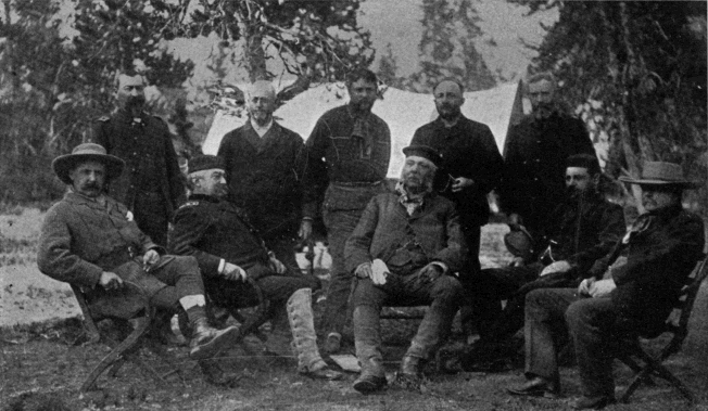
Presidential Party of 1883.
1. John Schuyler Crosby, Governor of Montana Territory; 2. Michael V. Sheridan, Lieutenant-Colonel and Military Secretary; 3. Philip H. Sheridan, Lieutenant-General, U. S. Army; 4. Anson Stager, Brigadier-General, U. S. Volunteers; 5. W. P. Clark, Captain Second Cavalry, U. S. Army; 6. Chester A. Arthur, President of the United States; 7. Dan. G. Rollins, Surrogate of New York; 8. James F. Gregory, Lieutenant-Colonel and Aide-de-camp; 9. Robert T. Lincoln, Secretary of War; 10. George G. Vest, United States Senator from Missouri.
The most elaborate expedition that ever passed through this region took place in August, 1883. [AN] It included among its members the President of the United States, the Secretary of War, the Lieutenant-General of the Army, a United States Senator, and several other distinguished officers and civilians. The interesting part of the journey lay between Fort Washakie, Wyo., and the Northern Pacific Railroad at Cinnabar, Mont. The party traveled entirely on horseback, accompanied by one of the most complete pack trains ever organized in this or any other country, and escorted by a full troop of cavalry. Couriers were stationed every twenty miles with fresh relays, and by this means communication was daily had with the outside world. The whole distance traveled was 350 miles, through some of the wildest, most rugged, and least settled portions of the west. No accident or drawback occurred to mar the pleasure of the expedition. The great pastime en route was trout fishing, in which the President and Senator Vest were acknowledged leaders. The phenomenal “catches” of these distinguished sportsmen might pass into history as typical “fish stories,” were they not vouched for by the sober record of official dispatches, and the unerring evidence of photographer Haynes' camera. The elaborate equipment of this expedition, the eminent character of its personnel, and the evident responsibility resting upon those who conducted it, attracted a great deal of attention at the time, and gave it a prominent place in the annals of Western Wyoming. [AO]
To these various expeditions must be added the extensive, though desultory, explorations of P. W. Norris during the five years that he was Superintendent of the Park.
It has thus come about that the Yellowstone National Park, though remote, inaccessible, and of great extent, is about the most thoroughly explored section of the United States. Within the territory bounded by the 44th and 45th parallels of latitude, and the 110th and 111th meridians of longitude, there are nearly four hundred geographical names. The names of hot springs and geysers would probably double the number. To appreciate this fact, it must be remembered that there are no settlements in the Park, and that counties, townships, cities, and villages, which on ordinary maps form so large a proportion of the names, are here entirely absent. That region has indeed been a paradise for the explorer, the topographer, and the geologist; and its splendid opportunities have not gone unimproved.
Although not strictly in the line of original exploration, the few winter journeys that have been made through the Park may nevertheless most appropriately be considered in this place, reserving for a later chapter a description of the difficult and hazardous nature of these undertakings. The first of these expeditions was in 1887, under the auspices of the New York World, and was led by Frederick Schwatka, the Arctic explorer. It was organized on a grand scale, “with Arctic ‘sleeping bags,’ the Norwegian ‘ski,’ the Canadian ‘web’ snow shoe, and toboggans to carry supplies, photographic equipment, and astronomical instruments.” But the elaborate outfit proved fatal to the enterprise, which quickly resulted in a magnificent failure. The conditions were different from those in Arctic travel, and the recent fall of light snow negatived any attempt to move toboggans through it successfully. The party consumed three days in getting to Norris, a distance of twenty miles. Here Lieutenant Schwatka became ill and the expedition was abandoned.
But Mr. F. J. Haynes, the well known Park photographer, who had accompanied the party, resolved to continue the tour in order to secure a collection of winter views. Three other members of the party joined him. They abandoned the toboggan and strapped the baggage on their backs. They went by way of the usual route to the Upper Geyser Basin, where they were snow-bound for five days in a fearful blizzard. Thence they went to the Grand Cañon, and from that point over Mount Washburn to Yancey’s. On this part of the trip the party nearly lost their lives, wandering for three days in a blinding storm without food or shelter. The circuit covered about two hundred miles, and the temperature ranged from ten to fifty-two degrees below zero during the entire trip of twenty-nine days.
In March, 1894, two very important winter expeditions were made in the Park. Mr. F. J. Haynes went through for the purpose of extending his line of winter views, and also of photographing the Park game. Accompanying him was Felix Burgess, government scout.
Following this party by a few days, and joining it at the Grand Cañon, came another party with a staff correspondent of Forest and Stream. This gentleman, Mr. E. Hough, of Chicago, Ill., made the entire round of the Park, studying its game and other similar matters. [AP] His narrative, published in Forest and Stream, forms one of the most entertaining and valuable contributions yet made to the literature of the Park. These two expeditions played an important part in securing the enactment of the National Park Protective Act, in May, 1894.
CHAPTER XIII.
AN INDIAN CAMPAIGN THROUGH THE YELLOWSTONE PARK.
In a letter dated at Fort Ellis, Montana Territory, August 19, 1877, addressed to the Hon. George W. McCreary, Secretary of War, the writer, General W. T. Sherman, then on a tour of inspection of the “country north of the Union Pacific Railroad,” tells of his recent visit to the Yellowstone National Park. This was about the period when our Indian wars in the Far West were at their height. Only a year had elapsed since the Custer massacre. It was the crisis of the Indian military question. There was at that time scarcely a spot in the whole Missouri and Yellowstone Valleys that was safe from Indian depredations. Naturally, therefore, General Sherman had his mind upon this subject when his small party, comparatively unprotected, were traveling through the wilds of the National Park. But he saw nothing there to excite his fears, and in the letter above referred to, says: “We saw no signs of Indians and felt at no moment more sense of danger than we do here.” It will presently be seen how delusive was this fancied security, and by how narrow a margin it escaped resulting disastrously to the General’s party.
The tour from Fort Ellis to the Park and return had taken from August 4th to August 18th. On the latter date, the party met an ingoing company of tourists from Helena composed of the following persons: A. J. Weikert, Richard Dietrich, Frederic k Pfister, Joseph Roberts, Charles Kenck, Jack Stewart, August Foller, Leslie Wilke, L. Duncan, and Benjamin Stone (colored cook). The party followed the usual route to the Grand Cañon and Falls of the Yellowstone, where they were in camp August 24th.
As they were entering the territory of the Park, another party was on the point of leaving it after a tour of about two weeks. This party was composed of the following persons, most of whom were from Radersburg, Montana: George F. Cowan and wife, Frank and Ida Carpenter, brother and sister of Mrs. Cowan, Charles Mann, William Dingee, Albert Oldham, A. J. Arnold, and a Mr. Meyers. They had formed a permanent camp in the Lower Geyser Basin, where the Fountain Hotel now stands, and from that point had made daily short excursions to the various localities of interest. They all visited the geyser basins and some of the party crossed to the Lake and Cañon of the Yellowstone. They must have been seen by Sherman’s party, for they were directly in his route. The party had completed their tour of the Park, August 23d, and had arranged to set out for home early on the following morning.
In order to understand the unfortunate turn which the affairs of these two tourist parties were about to take, it will be necessary to explain, in briefest outline, the cause and previous incidents of one of the most remarkable Indian campaigns in our history.
From the time of Lewis and Clark, the Nez Percé Indians had dwelt in what are now the States of Oregon, Washington, and Idaho. Their territory extended from the Salmon River on the south to the Pelouse River on the north, and from the Bitter Root Mountains westward into the present States of Idaho and Washington. In 1855, they ceded to the United States a part of their territory, and the principal chiefs located in the several portions of the remainder. In 1860, gold was discovered on the reservation and the usual gold rush followed. The danger of a conflict with the Indians became so great that a temporary arrangement, pending action by the government, was made between them and their Indian agent, opening a portion of the reservation “to the whites in common with the Indians for mining purposes.”
But the settlers did not stop with these concessions. In defiance of law, they built the town of Lewiston on the reservation, and gave other proofs of their project for permanent occupancy. It soon became necessary for the government to take some decisive step, and this was accomplished in 1863 by a new treaty in which the Indians relinquished three of their most important valleys, the Wallowa, the Alpowai, and the Salmon River.
The treaty, however, was far from receiving the general assent of all the chiefs. A formidable faction, headed by Chiefs Joseph, Looking Glass, Big Thunder, White Bird, and others, refused to be bound by it, and were henceforth referred to in official reports as the “Non-treaty Nez Percés.” For a time the authorities made no effort to enforce the new treaty, and the Indians were “tacitly permitted to roam” over their ancient hunting-grounds.
This condition of affairs continued for thirteen years with various efforts in the meantime to arrive at some more satisfactory settlement. Finally, in 1876, a civil and military commission was appointed to visit the Nez Percé Indians, to examine into their grievances, and to determine what measures were necessary for a permanent settlement of the question. The report [AQ] of this Commission is interesting, both for the facts it relates in regard to the tribal life and characteristics of the Nez Percé Indians, and for the heroic treatment of the long-standing troubles which it recommends.
These Indians were altogether a peculiar people. The early missionaries had converted them to the Christian faith, and, whether from that cause, or from natural proclivity, they were among the most religious of our Indian tribes. There is a general concensus of authorities that, despite certain grave defects of character, they were, mentally and morally, far above the average Indian. In later times, approaching the period covered by this sketch, they fell under the influence of a class of mystics called “dreamers,” who taught a doctrine of land ownership which was the immediate cause of all their subsequent troubles. This doctrine was, in substance, that “the ‘Creative Power,’ when he made the earth, made no marks, no lines of division or separation, upon it, and that it should be allowed to remain as it is;” that it “should not be disturbed by man, and that any cultivation of the soil, or other improvements, any voluntary submission to the control of government,” were incompatible with the true purpose for which it was made. At bottom it was the broad principle that no man or aggregation of men can take from other men the right to enjoy what nature has made free for all. Why the Commission should characterize this doctrine as “pernicious,” unless a thing is pernicious whenever it is impracticable, is not easy to understand. From the point of view of the nomadic life of the redmen, it is hard to conceive a theory of land tenure, or the want of it, more nearly approaching a perfect ideal.
Unfortunately for such a doctrine, at the point at which American history had now arrived, it was no longer possible of realization; and any attempt to put it in force could not result otherwise than in failure. So it was with Joseph and his followers. The government for a long time overlooked their infractions of the Treaty of 1863, but finally was compelled to interfere. The Commission recommended that the existing treaty be enforced, by military aid if necessary. The recommendation was approved, and to General O. O. Howard fell the task of putting the Indians on their proper reservation.
For a time it seemed that they would be induced to submit without the employment of active force; but just as success was apparently assured, the Indians murdered some twenty white men, women, and children, in revenge for one of their number killed the previous year. Peaceful negotiations came at once to an end, and the military authorities assumed control of the situation. This was June 13, 1877.
Between that date and July 12th, three battles were fought, in which both sides suffered severely, and the Indians displayed extraordinary fighting ability. They then left their country—as it proved, not to return—and set out across the mountains to their oft-visited “buffalo country,” in the Judith Basin, far to the eastward of the Upper Missouri.
But their route lay too close to the military post of Fort Missoula and to the towns in the more thickly settled portions of Montana. They bore off to the southward, through a country with whose people they were well acquainted, and with whom they had often traded in previous excursions to the buffalo country. Here they found friends and obtained the supplies they needed.
In the meantime, General Gibbon, with a small force, which he had gathered from Forts Benton, Shaw, and Missoula, and from volunteers among Montana citizens, was in close pursuit. He overtook the Indians on the Big Hole River, in South-western Montana, where a desperate battle ensued, in which his own force was severely handled.
The Indians then passed south into Idaho, with Howard in pursuit, swung around to the east, and re-crossed into Montana by way of Henry Lake. Near Camas Creek, they had an engagement with the pursuing troops.
Howard arrived at Henry Lake at 8 A. M., August 23d, just as the Indians had left. The long marches compelled him to halt at this point for three or four days, to rest his men and replenish his supplies. This gave the Indians a considerable start, of which, however, they took only a leisurely advantage. Their route lay across the Yellowstone Park, which they entered by Targhee Pass, and on the night of August 23d they encamped on the Firehole River, in the Yellowstone National Park, a short distance from where we left the Radersburg tourists, and less than twenty miles from the camp of the Helena party. The interest of the campaign for the next week centers chiefly upon the fortunes of these unlucky excursionists.
Before sunrise on the morning of August 24th, Arnold and Dingee, who had got up to prepare the camp fire, saw Indians approaching. The rest of the party were promptly aroused. The Indians at first professed to be friendly and little alarm was felt; but the party nevertheless had no appetite for breakfast, and immediately broke camp and started down the river toward home. But they were soon surrounded by the increasing number of Indians, who began to give indications that trouble was at hand. They were told that it would be unsafe to proceed down stream further, that the only course was to turn back with the Indians. This they were soon forced to do. After traveling some two miles up Nez Percé Creek, it became impossible to take the wagons further. The horses were unhitched and the ladies mounted upon them, and in this manner the march was resumed. At this point Mr. Frank Carpenter was induced to hasten to the front in search of Chief Looking Glass to see if he could not secure the party’s release; but his suspicions becoming soon aroused, he refused to go further, and returned. In fact, it turned out later that Looking Glass was not in front at the time and that the pretense that he was, was a mere subterfuge to aid in scattering the party. The captives were now taken up the East Fork of the Firehole (Nez Percé Creek) to the foot of Mary Mountain, where a consultation with the chiefs was had. Mr. Cowan was spokesman for the whites, and Poker Joe, who knew English well, for the Indians. The party were here set at liberty, their horses, guns and ammunition were taken, they were given other horses instead, and, just as the Indians were about to resume their march, they were told to depart by the back trail. After proceeding some three-fourths of a mile, they were overtaken by some seventy-five young and war-painted bucks, and were compelled to countermarch. It was about this time that two of the party were given a hint by a friendly Indian and made their escape in the brush. The rest continued their way back to the point where they had been liberated and some distance beyond in the direction of Mary Lake. Just as they reached the first sharp ascent of the mountain about 2 P. M., in the midst of dense timber, the attack began. At the first fire Cowan was struck in the thigh and fell from his horse. His wife instantly rushed to his side, threw her arms around his neck, and strenuously resisted the Indians in their further attempts to kill him. But they partially pulled her away and an Indian shot Cowan again in the head. He was then left for dead.
In the meantime, Carpenter had had a narrow escape. A young Indian had drawn his revolver upon him, when Carpenter, remembering his religion, quickly made a sign of the cross. He was then hid by the Indians in a clump of underbrush until the trouble was over, and was assured that the ladies should not be harmed. [AR]
The other members of the party scattered promptly when the firing began. All of them escaped to the brush, but one of them was wounded in the attempt, and fell behind a log where he lay concealed until the Indians had gone.
This left Carpenter and his two sisters captive. They were taken along with the Indians, each being lashed to a pony behind an Indian. The captives became separated and did not see each other until ten o’clock that night at the Indian camp near Mary Lake. The next day, August 25th, the march was resumed, and the party were taken across the Yellowstone at the ford near Mud Geyser. Here Carpenter’s fate was put to a vote of the chiefs and by a majority of one he was given his life. In the afternoon, the ladies were given each a pony, and, with Carpenter, were escorted by Poker Joe back across the river. They were then taken a mile down stream and told to depart—instructions which they obeyed with no want of alacrity.
Strange to say none of the party had been killed. Cowan, who had been twice shot, and stoned also by the Indians, when they saw lingering evidences of life, nevertheless survived. About five o’clock in the afternoon he recovered consciousness, and drew himself up by the bow of a tree, when lo! close behind him was another Indian with his rifle ready to fire. He tried to get away, but the Indian fired and the ball passed through his left hip. He now gave up hope as he fell again to the ground. The Indian, however, did not come up. After waiting until every one had apparently gone, Cowan crawled along till about midnight, seeking a place of greater safety, and then waited for day. At daybreak he commenced crawling back toward the old camp, a distance of eight or ten miles. He passed the abandoned wagons on the way, where he found a dog belonging to the party. It took him four days to reach the old camp, but once there he found matches, coffee, and some other articles which helped him to keep alive. The day after his arrival, he was picked up by Howard’s scouts.
Arnold, who had escaped to the brush before Cowan was shot, and had wandered for four days until finally picked up by Howard’s command near Henry Lake, came along with the troops on the 29th, and remained with Cowan until their arrival in Bozeman. They were taken by Howard to near Baronett’s Bridge, and then sent down the river.
Already Carpenter and his sisters had made their way down the river, passing close to the camp of the other party of tourists near the Falls—whom they might have saved had they chanced to see them—and were met by a party of soldiers under Lieutenant Schofield twelve miles from Mammoth Hot Springs. They were escorted to the springs, whence they went to Bottler’s ranch, some distance below the Park, and a short time afterward returned to Radersburg. It was about two weeks before Mrs. Cowan learned that her husband was still alive. After all these miraculous escapes, it is interesting to know that Mr. Cowan and his wife survived to make another tour of the Park a few years later under better conditions.
It will not be necessary to follow in detail the fortunes of the rest of the party. They all escaped, though with much suffering, in their wanderings through the wilderness.
When the captive members of the party were being marched down the Yellowstone slope east of Mary Lake, they heard considerable firing in the timber to their right. This is thought to have been an attack upon two prospectors who were known to have been in the neighborhood at the time, and who have never since been heard of.
The party of Helena tourists in camp near the Falls of the Yellowstone on the night of August 24th, were less fortunate than the Radersburg party. On the morning of the 25th, they started up the river toward the Mud Geyser. They had gone about a mile beyond Sulphur Mountain when they discovered moving bodies of men, part of whom were fording the river. Careful scrutiny showed them to be Indians, and the party rightly divined that they must be the hostile Nez Percés. They hastily retraced their steps and went into camp in the timber near the forks of Otter Creek, about a mile and a half above the Upper Falls of the Yellowstone. Here they remained undisturbed all day and the following night. On the morning of the 26th, Weikert and Wilkie set out to scout the country. They went as far as Sulphur Mountain, and finding every thing clear, started back to camp to report. When entering the timber just north of Alum Creek, they suddenly met a band of Indians who promptly opened fire on them. A flight and pursuit of considerable duration ended in the escape of both men; but not until Weikert had been wounded. This party of Indians had just attacked and dispersed the group in camp. They had stolen upon the camp as dinner was being prepared, and a volley of musketry was the first warning the tourists had of their presence. There was instant flight and most of the party managed to get away. But Kenck was soon overtaken and killed; and Stewart after being severely wounded, prevailed on the Indians to spare his life.
Weikert and Wilkie, who had hastened back to camp after their own encounter, found every thing in confusion, and all the party gone. They soon fell in with several of them, and together they set out for Mammoth Hot Springs.
And now began another series of wanderings through the trackless wilderness of the Park. Two of the party made their way by way of the Madison River, where they were given food by soldiers, to Virginia City and thence to Helena. The rest of the survivors after much hardship reached Mammoth Hot Springs, and soon after left the Park with the exception of Weikert, Dietrich, the colored cook, Stone, and a man named Stoner.
On August 31st, Weikert and one McCartney, owner of the first hotel ever built in the Park, went to the Falls of the Yellowstone in order if possible to learn the fate of the missing members of the party. Shortly after their departure from the Springs a band of Indians prowled across the country from the Yellowstone to the Gardiner and went down the latter stream as far as Henderson’s Ranch near the present town of Cinnabar. After a brief skirmish and a general pillage here, they went back to Mammoth Hot Springs. Stoner and the colored cook fled precipitately, but Dietrich, believing the Indians to be friendly scouts, remained behind and was shot dead in the door of the hotel. Stone made a lucky escape by climbing a tree, and his subsequent ludicrous recital of his experience became a standing jest among the inhabitants of the Yellowstone.