Chapter I · Geographical Description of the Sulu Archipelago1
Reading edition
In general
The Sulu Archipelago is a series of small volcanic islands which extends in a northeast and southwest direction between the meridians of 119° 10′ and 122° 25′ east, and the parallels of 4° 30′ and 6° 50′ north. It forms a continuous chain of islands, islets, and coral reefs, which connects the peninsula of Zamboanga with the northeastern extremity of Borneo and separates the Sulu Sea from the Celebes Sea. It marks the southern line of communication between the Philippine Islands and Borneo and is probably the chief route of former emigrations and travel from Borneo to Mindanao and the southern Bisayan Islands.
The islands of the Archipelago are so disposed as to form several smaller groups, the most important of which are the following: The Basilan Group, the Balangingi or Samal Group, the Sulu Group, the Pangutaran Group, the Tapul or Siasi Group, and the Tawi-tawi Group.
The Basilan Group is the first on the north and includes the Island of Basilan and fifty-six small adjacent islands, all of which lie north of the parallel of 6° 15′ north and east of the meridian of 121° 19′ east. This group, under the name of Basilan, constituted the sixth district of the politico-military government of Mindanao, organized by the Spanish Government in 1861. Since that date the islands forming this group have not been recognized politically as a part of the Sulu Archipelago.
Basilan is the largest island in the Archipelago. Its northernmost point is about 10 miles directly south of Zamboanga. The island is more or less circular in outline and has a radius approximately 11 miles long. Its area is about 400 square miles. Two prominent headlands projecting, one on the east and one on the west, give the island a maximum length of 36 miles. The greatest width, north and south, is 24 miles. The eastern headland is long and has a picturesque, conical peak, called Mount Matangal, which rises about 648 meters above sea level. This peak is a very prominent landmark, visible to a great distance from all points in the Celebes Sea and in the Straits of Basilan. The western headland is less prominent. It has an isolated peak about 287 meters above the sea, immediately north of the settlement of Pangasa’an. The position of this peak makes it a conspicuous landmark to vessels entering the Straits of Basilan from the Sulu Sea.
The surface of the island is high and hilly. Twenty-three peaks are recognized, forming two distinct series or ranges, central and peripheral. The central region of the island is an elevated tableland, out of which rise a number of peaks forming the central series and ranging from 609 to 1,019 meters above sea level. A thick forest covers this region. The rivers are small and dry up in the dry season. Few Yakans are to be found there, and their houses are isolated and far apart. No cultivation is carried on in the interior. On the outside of this region rises the peripheral series of hills or peaks which lies parallel and near to the coast. With the exception of two, all of these peaks are below 304 meters in height. The drop from this line of hills to the coast is rapid in some places, and in general the shore line is low and swampy and covered with mangrove trees. The three largest valleys in the island are those of Gubawan or Lamitan on the northeast, Kumalarang on the northwest, and Malusu on the west. This region is generally considered fertile, but it has a marked dry season and droughts are not rare.
Isabela may be considered as the capital of Basilan. Its old name is Pasangan, which is still the name of the stream at the mouth of which it is built. The town is situated 4 miles inland, on the narrow channel which separates Basilan from the small island of Malamawi. The channel widens a little at this point and forms an excellent harbor. Under Spanish jurisdiction it was a naval station with a dry dock for gunboats. An aqueduct furnishes the town with fresh water brought from a small stream in the neighborhood. The stone fort Isabel II, built on the hill in 1842, commands both entrances of the channel. It was designed to defend the town against the Moros. The abandonment of the town as a naval station has led to its present decline. An American sawmill planted there has been the chief source of lumber supply for the town of Zamboanga and neighborhood.
The largest islands in this group, excepting Basilan, are Baluk-baluk and Pilas, both of which lie west of Basilan. A narrow channel which lies in the direct route leading from Zamboanga to Jolo separates these two islands. Tapiantana, Salupin, Bubwan, and Lanawan are the largest islands of the group south of Basilan.
The population of this whole group is generally estimated at 25,000. Of these, 15,000 live in Basilan itself. The inhabitants of Basilan proper are Yakans and Samals, while the adjacent islands are occupied entirely by Samals. The Yakans are the aborigines of Basilan and extend farther into the interior than the Samals.
The Balangingi Group lies east of the meridian of 121° 28′ east, and to the south of the Basilan Group. It has nineteen islands, the principal ones of which are Tonkil, Balangingi, Simisa, Tatalan, Bukutwa, Bulim, Bangalaw. The islands of this group are small and low and do not exceed 38 square miles in area. Their inhabitants are Samals. The people of Balangingi and Tonkil were notorious pirates. They built strong forts and once surpassed all other Samals in power, political organization, and prosperity.
The Sulu Group lies west of the Balangingi Group and north of the parallel of 5° 46′ north. Its western boundary may be sent at the meridian of 120° 46′ east. It consists of about twenty-nine islands with a total area of 380 square miles. The principal island of this group is Sulu. To the north of Sulu lie Pangasinan, Marongas, Kabukan, Bubwan, Minis, Hegad, and a few others; to the east lie Tulayan, Kapwal, and Bitinan; to the south, Pata and Patyan.
Tulayan lies north of Tandu and is separated from it by a narrow strait. It has a good harbor on the southern side. It was ceded to the English in 1763 by Sultan Alimud Din I out of appreciation of the favor done in releasing him from prison in Manila and reinstating him as Sultan of Sulu. The English, however, never made any use of the island.
Pata is, next to Sulu, the largest island of the group. It is mountainous and well populated. The description of the Island of Sulu is given separately at the end of this chapter.
The Pangutaran Group lies west of the Sulu Group and north of the sixth parallel. It has fourteen islands and an area of 72 square miles. The principal members of the group are Pangutaran, Pandukan, North Ubian, Laparan, and Tababas or Cap. They are all low and flat with little more than trees visible from the sea. They are surrounded by coral reefs and sand banks, which in places form lagoons which can be entered only at high water. The drinking water in these islands is brackish in the hot season and has a black color during rains. Very often the people go as far as the Island of Sulu to get good water. Pangutaran is the fifth island in the Archipelago in size, being 11 miles long, north and south, and 8 miles wide, from east to west. Its chief settlement is Maglakub. Its northern and eastern coasts are the best populated. The inhabitants of this group are chiefly Samals; few Sulus are found mixed with them. Coconut trees and tapioca plants grow well in places.
The Siasi Group lies to the south and west of the Sulu Group, east of the meridian of 120° 33′ east, and north of the parallel of 5° 24′ north. It has thirty-eight islands with an aggregate area of 77 square miles. Its population is estimated at 20,000. The principal islands of this group are Siasi, Pandami, Lugus, Tapul, Laminusa, and Kabinga’an. The first four are volcanic islands of some size; the last two are low and flat. Tapul is the nearest island of the group to Sulu. It is more or less round in circumference and rises in the middle to a picturesque conical peak 505 meters above the sea. It is about 5 miles in diameter and is separated from Lugus by a very narrow channel. The island is 8 miles south of Sulu Island, is well cultivated, and appears very attractive from the sea. It supports a considerable population and has several fairly prosperous settlements. The people are mostly Sulus; they are very warlike and take great pride in their traditions.
The chief settlement of this island is Kanawi, where lives Sharif Alawi, the strongest chief on the island. Buhangin Hawpu, Pangpang, and Pagatpat lie on the southern coast, east of Kanawi. The settlements on the western coast are, beginning at the south, Suba Pukul, Kawimpang, Tigbas, Banting, Kutabatu, Bagus; on the northern coast, Kawimpang, Pangdan; on the eastern coast, Sampunay, Tulakan.
Lugus is a larger island. Its long diameter extends 9 miles east and west, and it has an area of 18 square miles. It is hilly and rough; but the northern shore is fairly well cultivated.
The chief settlements are on the western coast. They are Basbas, where Datu Amilusin used to live, and Bulipungpung. On the north lie, beginning at the east, Gapas, Ba’it-ba’it, and Hawit, the place of Maharaja Sharafud Din; on the east Kalu’ukan, the residence of Panglima Salahud Din; and on the south Aluduyung, and the Island of Munupunu.
Siasi and Pandami are separated by a narrow channel which forms a good anchorage for vessels. Siasi is prettier than Tapul in form and is larger, but not equally wooded. It has an isolated, conical, and beautiful peak in the center rising to a height of 509 meters above sea level. The island is about 7 miles in diameter and has an area of 39 square miles. Reefs and numerous islets form a fringe off the east and south coasts and these teem with Samal houses. It is thickly settled, fairly well cultivated, and has, in proportion to its size, a considerable number of horses and cattle. The majority of the people are Samals, but the chief rulers and some of their retinues are Sulus. In this respect this island follows the general rule governing all the larger islands of the Archipelago outside of Sulu Island. The town of Siasi is on the western side. It lies on the Pandami Channel and has a good harbor. A spring rising at the base of the western slope of the mountain supplies the town with fresh water.
A detachment of Spanish troops occupied the town in 1882 and built a stone fort and barracks. American troops were there from 1900 to 1904, when they were relieved by a detachment of the Philippine Constabulary. An effort was made in 1899 by the present sultan, Jamalul Kiram II, to retain Siasi under his own jurisdiction for the establishment of a custom-house where he could collect duties on foreign goods, as was formerly done by his father; but no such rights were conceded to him. Siasi is a closed port at present. The residents of the town are Samals and Chinese traders. They vary from 500 to 700 in number. The other settlements on the island are, on the north, Siyundu, Pagatpat, and Manta; on the east, Pamungunan, Tanjun, Sipanding, and Bulikulul; on the south, Dugu, Latung, and Musu; on the west, Nipanipa, Jambanganan, Dungus, and Sablay; in the interior, Kabubu, Ju, and Kungatad. Siasi and Laminusa are important centers of pearl and shell fishing. About 2,000 Samals live on Laminusa.
Pandami is an attractive island. Its long diameter runs north and south. Two round peaks, one at each end of the island, give it the shape of a saddle and make a picturesque sight from the sea. The people are chiefly Samals ruled by Sulu datus. Its best settlements are on the west and south. The name given to this island on Spanish maps is Lapak, which is the name of one of its southern settlements. The northern extremity of the island is Diadia Point, the northeast projection is Butun Point. The chief settlements on the west are, beginning at the north, Subasuba, Tabunan, Pari’an Pandami, Tubig-shina, Lahi, and Sibawud, which lies on a reef off the southern point of the island. On the east lie Ambilan, Bakal, and Lapak. Laminusa and Kabinga’an lie to the east of Siasi. They are small but thickly populated by Samals. The chief settlements of Laminusa are Tampan on the north and Kungkung on the south.
The Tawi-tawi Group lies to the south and west of the Tapul Group and extends as far west as the Sibutu Passage. This is the largest group in number and area, including eighty-eight islands with a combined area of 462 square miles. Its population is estimated at 25,000. These islands form two distinct divisions or subgroups, differing in both extent and population.
The first or northern division includes Bangao, Sangasanga, Tawi-tawi, Tandu-batu, and a large number of smaller islands, all of which are rough, volcanic, mountainous, and very sparsely populated. The second or southern division is a series of low, flat islands which are smaller in area but more thickly populated than those of the northern division. The principal names, beginning at the east, are the following: Kinapusan, Bintulan, Tabawan, South Ubian, Tandubas, Sikubun, Lata’an, Mantabwan, Banaran, Bilatan, Manuk-manka, and Simunul. Extensive reefs and narrow channels and shoals separate these islands from one another and from those of the northern division, rendering navigation between them impossible except in vessels of very light draft.
Bangao, Sanga-sanga, and Tawi-tawi are separated by very narrow channels and are practically one island. Bangao forms the southwest extremity and is substantially one solid rock which rises perpendicularly to a height of 228 meters. It is a conspicuous landmark to vessels going through the Sibutu Passage. The town of Bangao is a military station and an open port; it has an excellent landlocked harbor and a very poor water supply. The town has been occupied by troops since 1882, but it has never attained any size or importance.
Tawi-tawi Island is a continuous range of hills covered by thick and rich forests. The highest points in the range are the Dromedary peaks (591 meters) lying about the center of the island. The length of the island is about 34 miles and its greatest width 14 miles. It is next in size to the Island of Sulu, but it is very sparsely populated. Its chief settlements are Tungpatung, Balimbang, Lissum, and Bu’an on the south coast, and Tawi-tawi, Tata’an, Butung, Tumhubung, Tumbaga’an, Languyan, and Bas on the north. At Balimbang are built the best types of Sulu and Samal boats. Good timber abounds in the neighboring hills, and the little bay is transformed into a shipyard. The town used to be a famous rendezvous for Samal pirates. Tata’an had formerly a Spanish garrison; the present Moro town is a little distance to the south of the ruins of the fort and is called Butung. It is built on the hillside and commands a pretty view of the sea. It lies 100 miles east of Lahat Datu, East Borneo. The anchorage is deep and safe, being well protected by a large semicircle of reefs. A boa 30 feet long was killed on the island in 1903. Rubber and gutta-percha are found on this island. Tapioca and ubi are the staple products.
Sibutu lies in a little group of the same name, situated between the Tawi-tawi Group and Borneo and at a distance of about 15 miles from each. The Sibutu Passage separates it from Manuk-manka, the southernmost island of the Tawi-tawi Group, and the Alice Channel from Borneo. This island did not lie within the limits of the Philippine Islands as defined in the Treaty of Peace of December 10, 1898. It was ceded by Spain with Kagayan Sulu, by a separate treaty in November, 1900. Its close proximity to Borneo renders it a convenient stopping place for small Moro boats navigating between Borneo and Sulu. Sitanki, an island and town, is the trade center of this group, and has just lately been made an open port.
Island of Sulu
Geographical features
Sulu is an island of irregular shape and among the islands of the Archipelago is next in size to Basilan. Its longest diameter runs east and west and approximates 37 miles, while its average length does not exceed 32 miles. Its greatest width is 14 miles and its average width about 10 miles. The main structure of the island is volcanic, but it is surrounded with a coral reef formation, which is most extensive in the bays and on the south.
Two indentations of the northern shore at Jolo and Si’it and two corresponding indentations of the southern shore at Maymbung and Tu’tu’, divide the island into three parts—western, middle, and eastern.
The Bay of Jolo is quite open and faces the northwest. It is very shallow near the shore and its head constitutes the roadstead of Jolo. The Bay of Maymbung is a deeper indentation, but it is narrower and shallower than the Bay of Jolo. The town of Maymbung lies at the head of the bay and is about 9 miles south of Jolo in a direct line.
The Bays of Si’it and Tu’tu’ indent the island to such an extent as to leave only a neck of land, less than 4 miles wide, connecting the middle and eastern parts of the island. The settlement of Si’it lies at the head of the bay and in the immediate vicinity of a small lake of the same name. The shores of the Bay of Tu’tu’ are marshy and are covered with mangrove trees. The bay is very shallow to a considerable distance from shore. Tu’tu’ is the principal settlement near the head of the bay.
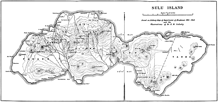
Sulu Island.
Toward the east, the ridge descends to a much lower level at Bud Datu, Bud Agad, and Bud Pula, which lie immediately to the south of Jolo. It rises again in Mount Dahu to an altitude of 716 meters. Mount Dahu is a prominent landmark and forms the most picturesque landscape in the background of Jolo. It is a steep and conical extinct volcano, similar to, but smaller and more regular in form than Mount Tumangtangis. East of Mount Dahu is another gap in which lies Tambang Pass. Beyond this the range rises again at Mount Tambang and continues uninterrupted to Mount Sinuma’an, at the extreme end of Lati, and Mount Bagshag. After Mount Bagshag the range descends gradually toward Su’ and Si’it. The northern slopes of Mount Tumangtangis and Mount Dahu, and the crest of Bud Datu are covered with grand forests, while the crests and lower slopes of Bud Agad and Bud Pula are partly cultivated and partly covered with tall grass.
From the shores of the Bay of Jolo the land rises gradually and presents a beautiful green appearance. The northern aspect of this whole range and its beauty were appropriately described by Mr. Hunt, as follows:
The highlands near the southern coast of the island divide into three separate regions. The first and westernmost lies west of Maymbung and forms the principal highlands of Parang. The highest points in this region are Mount Tukay, east of the town of Parang, and Mount Mabingkang, east of Tukay. To the east of Maymbung rise Mount Talipao and Mount Kumaputkut, which form the middle and second region. The third region is the southern part of the Lu’uk country. Its highest point is Mount Bulag, to the north of Tandu-Panu’an.
Between Mount Tukay and Mount Tumangtangis lies Bud Gapang. Midway between Mount Talipao and Bud Datu is Mount Kumuray, in the neighborhood of Langhub.
The largest streams on the island are Tubig Palag and Bina’an. The first is generally known as the Maymbung River. It passes through the settlement of Maymbung and empties into the head of the bay of the same name. It drains the southern slopes of Mounts Tumangtangis, Pula, Dahu, and Kumuray. The Bina’an stream drains the southern slopes of Mount Sinuma’an and the northern slopes of Mounts Talipao and Kumaputkut and empties into the Bay of Tu’tu’.
Principal coast settlements
Beginning at Jolo and going west along the northern coast we pass the following points of interest: The first is Point Baylam, the western limit of the Bay of Jolo. At the head of the small bay that follows lies the settlement of Matanda, where a Spanish blockhouse marks the western limit of the Jolo line of fortifications. Next comes Point Mangalis and the receding beach of Bwansa, the old capital of Sulu. Here and in the next bay, at Malimbay and Kansaya, Samal boats assemble in favorable weather for fishing. Back of these settlements the land rises rapidly to Mount Tumangtangis. A teak forest of considerable size lies between Tumangtangis and Jolo.
Buhanginan lies about midway between Patikul and Higasan. At the latter place or Tandu Manuk-manuk the shore line recedes toward the south. Opposite this point lies the Island of Bakungan. Next comes the larger settlement of Taglibi, above which rises Mount Ta’ung; then Bunbun, near a point which marks the western entrance into the Bay of Si’it. Midway between Bunbun and the head of the bay is Su’, which may be said to mark the boundary line between Lati and Lu’uk. Si’it is a small settlement near the head of the bay. Beyond Si’it the shore line turns north until it reaches Kansipat. About 2 miles farther, a semicircular reef off the shore makes the excellent and well-protected small harbor of Bwal. A large spring of pure, fresh water adds to this place another natural advantage, one which gave it the prominence it had in former days. The entrance into the harbor is very shallow and allows only sailboats of light draft. The channel lies close to the shore on the west side. Opposite the Island of Tulayan lie Tandu-batu and a little farther inland Kuta Makis. Limawa lies about 3 miles farther on near a point opposite the Island of Bŭli Kuting. Behind this island and at the head of a shallow cove lies Patutul, the chief settlement of Tandu. East of Bud Tandu is Tandu Pansan, the easternmost point of the island. The eastern coast is exposed to storms and appears rocky and barren, though the hills behind it are well cultivated.
The first point on the southern coast is Tandu Panu’an, behind which lies the settlement of Sukuban. This marks the southern extremity of the boundary line between Tandu and Lu’uk. The country behind Kuta Sihi’ and Pitugu appears rich and well tilled. The hills come down to the beach. Near the point at the eastern limit of Tu’tu’ Bay lies Kambing. The neighboring country is rich and prosperous. It is governed by Maharaja Bayrula, one of the wisest and best chiefs of Sulu. West of Kambing lie Pandang-pandang, Tŭbu-manuk, and Tu’tu’. The shore is a continuous mangrove marsh, while the country behind is about the richest and best tilled land on the whole island. The western side of Tu’tu’ Bay has few places of importance. The country behind is picturesque and hilly, but not as well populated as other parts of the island. Lubuk, Kabungkul, and Lumapit are the chief settlements.
Beyond the point of Buhangin Puti’, the shore line bends again north and the Bay of Maymbung begins. Here mangrove swamps are extensive and extend a good distance inland. The greater part of Maymbung is built on piles over the water. It is surrounded by swamps on all sides. After the tide recedes, strong odors arise from the muddy bottom to such an extraordinary degree as to render the atmosphere of the place very disagreeable and often unbearable to strangers. The center of the town is a small, open square of reclaimed land filled with coral rocks. Around this square were built the houses of Sultan Jamalul Aʿlam and his ministers of state. The present sultan lives on a hill about half a mile inland from the town. The square was probably the site of the Maymbung fort which was destroyed by General Arolas in 1887. Some Chinese traders live in the town and export hemp, pearls, pearl shells, etc., through Jolo. The population of the town and its immediate suburbs varies considerably, but it is generally estimated at 1,000. Beyond Maymbung the coast bends sharply to the south. In the immediate vicinity of Maymbung lies Bwalu. A mile west of this place begins the district of Parang. After Lipid and Lapa comes Kabali’an, the western limit of the Bay of Maymbung. The shore line then takes a more westerly direction. Passing Dandulit and Lakasan, we reach Tandu Pūt, where the western coast of the island begins. This southern region of Parang is well populated and is very pretty and productive. Cultivated areas are seen on the side of the mountains everywhere and they reach the very summit of Mount Tukay.
The town of Parang is one of the largest settlements on the island and has, at present, an estimated population of 1,000. It is situated at the head of a small open bay facing the southwest and commands a beautiful view of Tapul and Lugus and the intervening sheet of water. It is the capital of the district and has one of the best markets in the Archipelago for fish, shells, and pearls. The drinking water in this neighborhood is brackish.
An islet lies off the shore near Tandu Bunga. Beyond this point the shore line turns north to Bwisan, which is one of the most prosperous settlements in the district. Beyond Alu Pangku’ the coast inclines a little east and runs to Silankan and Timahu. Extensive coconut groves and well-cultivated fields and fruit trees of various kinds abound all along the coast from Parang to Timahu.
Districts of the island
The districts of the island conform in a great measure to its natural divisions. However, political reasons have modified the natural boundaries and increased the districts to six by division. These districts are Parang, Pansul, Lati, Gi’tŭng, Lu’uk and Tandu. The first district on the west is Parang. A line joining the western limit of Bwalu on the south coast, with a point slightly east of the summit of Mount Tumantangis, and projected to the sea on the north, delimits this district on the east and carves out of the western natural division the district of Pansul. The eastern boundary of Pansul is a line running from a point 2 or 3 miles east of Maymbung to Mount Pula and Busbus. The chief reason for separating Pansul from Parang was to reserve for the sultan direct control over Jolo and Maymbung. This district has more foreigners residing in it than any other.
A line joining Su’ and Lubuk marks the eastern limit of both Lati and Gi’tŭng, the third and fourth districts. The watershed line joining the summits of Mounts Dahu, Tambang, and Sinuma’an and falling on the east to the vicinity of Su’, divides Lati on the north from Gi’tŭng on the south. For all practical purposes the district of Lati may be said to lie between Jolo and Su’, and the district of Gi’tŭng or Talipao between Maymbung and Tu’tu’. The land joining Si’it and Tu’tu’ is low. Sulu traditions say that when the Samals arrived in the island this neck of land was submerged and the island was divided by a channel of water. The extinct volcano of Pandakan, generally spoken of as the “Crater Lake,” which lies in this vicinity, may be of late origin and may have been the source of the geologic deposits which helped to fill the channel. Spanish records speak of a volcanic eruption in the vicinity of Jolo as late as 1840, and it is very likely that other volcanic action occurred prior to that date and after the arrival of the Samals in the fourteenth century.
A line joining Limawa on the north and Sukuban or Tandu Panu’an on the south, divides Lu’uk from Tandu, thus forming the fifth and sixth districts respectively. A line joining Mount Tayungan and Bud Tandu divides both Lu’uk and Tandu into a northern and a southern part. In both cases the southern parts are more fertile and better cultivated and probably more thickly populated than the northern.
The Sulus are principally agriculturists. The greater part of the people are farmers and a considerable portion of the interior of the island is under cultivation. They raise a good number of cattle, carabaos, and horses, which they utilize for tilling the soil and transporting its products. Trails cross the island in all directions and the interior is in easy communication with the sea. Fruits are good and abundant. The forests are rich in jungle products and in timber. Some copra and hemp is raised and the amount is being increased annually. The staples are tapioca, rice, and corn. Sugar cane is raised in small quantities. Ubi and taro are fairly abundant. Some coffee is produced, but disease destroyed most of the plantations. Some tobacco and vegetables are raised for home consumption only.
In the extent and quality of cultivation the district of Lu’uk ranks first, Parang second, and Lati third. Good fresh water abounds everywhere except on the western coast. Considerable irrigation is possible in many localities.
Town of Jolo.
General plan, buildings and streets
Jolo is the Spanish representation (or rather misrepresentation) of the word Sulu, sometimes written Sooloo. The early Spaniards wrote it “Xolo,” which later changed to Joló. The complete form of the word is Sulug, as it is rendered in Magindanao. The Sulus pronounce it and write it Sūg. Sūg means a sea current. The flow of the tide through the innumerable narrow channels separating the numerous islands of the Archipelago gives rise to unusually strong currents which figure prominently in the seafaring life of the people. Therefore the term is an appropriate designation for the Archipelago as a whole.
The rulers of the island state have changed their capital four times. The most ancient capital was Maymbung, the second was Bwansa, which lies on the north coast of the island about 3 miles west of Jolo. Here ruled Raja Baginda and the first three sultans of Sulu. The fourth sultan moved to Sūg, the third capital, and the town remained the capital of the sultanate until 1876, the date of the Spanish conquest and occupation. Sultan Jamalul Aʿlam then moved to Maymbung and the Spaniards occupied the town. Since then the term Jolo has become so intimately associated with it, that it is deemed preferable to use it as a name for the town, while the term Sulu, which is more correct and more commonly used, is retained in all other applications.
The town of Jolo has been so closely identified with the history of the sultanate as to claim considerable attention. The Spanish buildings and improvements were sufficiently extensive to obscure the ancient landmarks of the town and to render a complete and intelligent understanding of the early history and traditions of the place impracticable. A few words describing the location of Jolo, its ancient landmarks, and the Spanish improvements will therefore be of primary interest.
The town as it stands at present is divided into four distinct parts. The main or central part is Jolo proper or the “walled town.” This is known to the Moros as Tiyangi Sūg meaning the “shops or market of Sulu.” The western half of this part bordering on Suba’ Bawang formerly was termed Luway. The second part, called San Remondo, lies back and south of the walled town and is separated from it by a little stream called Tubig Hasa’an. The third part is Tulay and lies on the west side; the fourth is Busbus, on the east side.
At the head of the roadstead separating the Pueblo nuevo or Tulay from Jolo proper or Luway is a small tidal stream formerly called Suba’ Bawang. Some maps designate it as Rio del Sultan. This stream extends back into a swamp and divides into two branches. The main or direct branch extends in a more or less southerly direction to a point about 700 meters from the mouth of the stream, where it rises in copious springs of fresh water at the edge of the swamp. The other branch is formed by the junction of the rivulet that rises in the springs of San Remondo with Tubig Hasa’an. The latter has its origin at the foot of the hills above the cemetery and Blockhouse No. 2. Hasa’an means grindstone, and the springs are said to have burst out of the spot where a grindstone was set for use. Another stream, termed Suba’ Ligayan, drains the northern slopes of Buds Datu and Agad, and running north, passes by Fort Asturias and through Tulay, and empties into the roadstead of Jolo at a point about 250 meters west of the mouth of Suba’ Bawang. A branch of this stream formerly issued at Asturias and connected with the main stream of Suba’ Bawang. The land which thus lay between Suba’ Bawang and Suba’ Ligayan was a delta. It was called by the Moros ū-laya (that is, the head of the net) because of its triangular shape. It was mostly marshy, but it had a central longitudinal strip of dry land which practically connected Tulay with the base of the hills, at Asturias. At the upper end of this strip there existed at one time a well-defined, sandy spot, different in formation from the surrounding land, which was considered sacred and was supposed to be the first land formed on the island. This spot was Sūg proper; after it was named the whole settlement which was built along the banks of Suba’ Bawang and at the head of the roadstead.
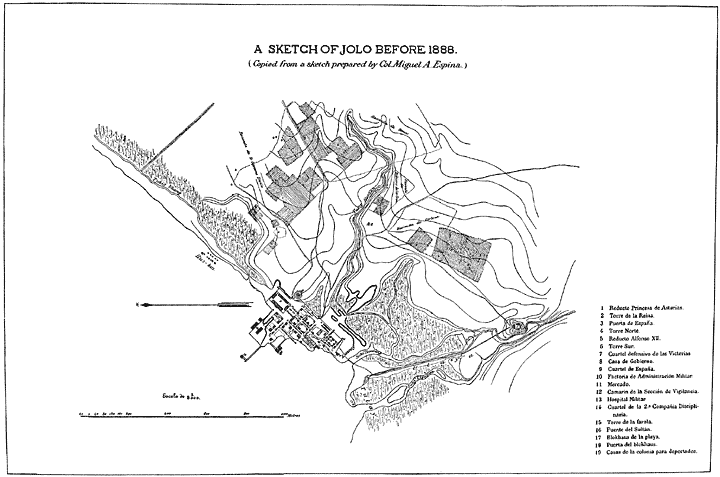
Sketch of Jolo before 1888.
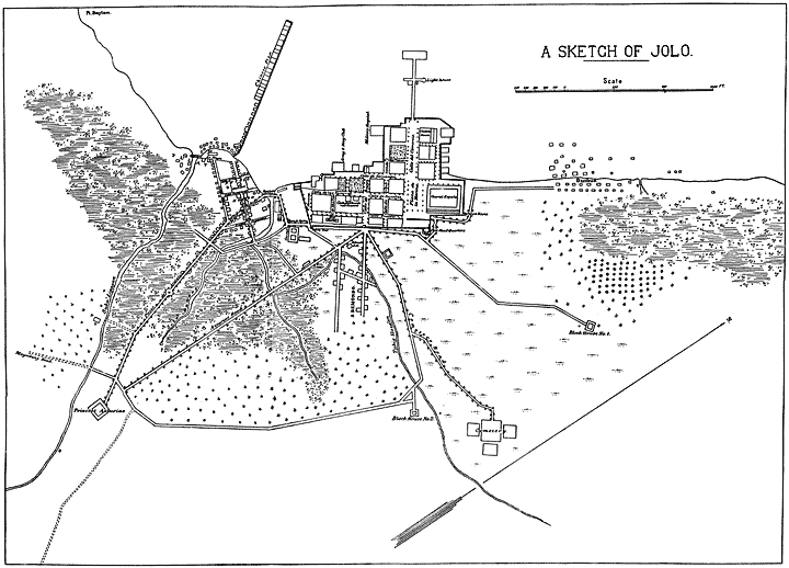
Sketch of Jolo at the present time.
The Sultan’s palace, termed istana, his kuta (fort) and stockades were built along the lower left bank of the stream Bawang; hence the name Rio del Sultan. On the right bank lay the houses and stockades of the other datus of high rank. Two bridges connected one side of the stream with the other.
On the outskirts of the town lay various kuta belonging to subordinate datus, which defended the approaches to the town. The most famous of these kuta was Daniel’s Fort, the best stronghold of Sulu. On the site of this fort was built in 1878 the fort or redoubt of Alfonso XII, which was lately replaced by the present headquarters building of the military post of Jolo. Another strong fort was built at the foot of the hills just above the head of the delta above described; it defended the inland approach to the town. This was Panglima Arabi’s kuta, on the site of which Fort Asturias was erected. Another kuta was located on Point Baylam.
The principal part of the town was formerly built over the shoal and beach at the head of the bay. Extensive rows of buildings stretched out into the roadstead and in front of the buildings now occupied as the clubhouse and military hospital. The present “Chinese pier” is constructed on the same plan. This extensive row of houses and shops begins at the lower point of the Tulay delta and stretches straight out into the sea. The bay is very shallow here and appears to be fairly well protected from severe storms. A variety of fish called tulay, after which the Moro town of Tulay is named, is caught in the bay. A swamp bounds the town on the south and west, affording it considerable protection from assault. However, it is open to attack from the sea and from the east. The land on the east is high and affords the only desirable site for residences. Here the strongest forts and defenses were erected.
In the immediate vicinity lay the Cuartel España, which was a large and substantial building occupying the northern extremity of the town, facing the bay on the side of Busbus. At the extreme end of the wall beyond the barracks was the tower or blockhouse called Torre Norte. Another similar tower at the south gate was termed Torre Sur. At the intersection of the south wall and the beach line was a strong building called Cuartel Defensivo de las Victorias. The block lying diagonally between this cuartel and the market had eight buildings which were known as Casas de la Colonia para Deportados.
Two roads and two bridges connected the south and southeast gates with San Remondo. The continuation of these roads formed the two main streets of this part of the town. San Remondo has six small town blocks, nearly all of which are on reclaimed swamp land. The buildings here are mere nipa huts and the streets are muddy and narrow, unlike those of the walled town. Back of the town lies a large coconut grove which extends to Blockhouse No. 2 on one side and Asturias on the other. A straight and well laid out road directly connects these two latter points and marks the southern limit of the town.
Busbus is wholly occupied by Moros. Its houses are dilapidated nipa huts built on piles over the water. Back of the town is a marsh which extends a little way toward the base of the hills. The water from the marsh escapes into the bay by two rivulets, the first of which runs through the settlement and is known as Tubig Uhang; the other is artificial, forms the outer limit of the town, and is called Buyung Canal. Persons convicted of capital crimes in the days of the independent sultanate were tied to a tree at this place and there their bodies were chopped to pieces; hence the name “Busbus” which means to “chop up” or “dress wood.”
Trade
Jolo lies about 4 miles from the point of intersection of latitude 6° north and longitude 121° east. It is about 540 nautical miles due south from Manila and 81 nautical miles distant from Zamboanga. The harbor is deep and free from currents. The bay is well protected on the north by the Islands of Pangasinan and Marongas and is safe from all storms except those from the northwest.
Such commercial importance naturally attracted the attention of the early Spanish Governors-General and was one of the causes which led to the early invasion of Sulu. The long period of warfare which followed this invasion retarded the progress of Jolo and reduced its trade. Again, the rise of Spanish commerce in the north tended to restrict the trade of Jolo. The growth of Manila, Cebu, and Iloilo naturally diverted the commerce of Luzon and the Bisayas and the north coast of Mindanao to those cities. The later commercial decline of Jolo was probably brought about more in this way than as a result of actual clash of arms. Jolo, however, remained an important port and a transshipping station to Mindanao until a late date.
At present trade has assumed new proportions and is following new routes. Zamboanga, Kotabato, and Davao are directly connected with Manila by regular steamship lines, and Jolo is fast losing its importance as a transshipping port. Zamboanga, on the other hand, is rising in importance and seems destined to become the port of Mindanao. It is the capital of the Moro Province and lies in the direct route connecting China, Manila, and Australia. It has direct communication with Manila, Hongkong, Singapore, and Australia, and is gradually diverting the trade of Mindanao from Jolo.
In spite of overwhelming odds, however, Jolo will maintain considerable commercial importance. It has well-established trade relations with Borneo, the Malay Peninsula, China, and Luzon, and is connected by regular steamship lines with Sandakan, Singapore, Manila, and Zamboanga. Practically the whole trade of the Sulu Archipelago passes through this port, and it stands now, as ever before, as the center of business, power, and importance of the whole district of Sulu.
In the early days the trade of Sulu was carried on by Moros and Chinese. The Chinese appear to have entered the Archipelago prior to its mohammedanization, and the commercial relations of China and Sulu are really prehistoric. As hostilities between Spain and Sulu increased, Sulu traders became less daring and grew fewer and fewer. Chinese traders, on the other hand, were less molested and conditions encouraged their increase. The “Chinese pier” is a very old business establishment, and Chinese traders and merchants have resided in Jolo for many generations. Their number, in 1851, exceeded 500. At present Chinese merchants have complete control of the trade of the Sulu Archipelago. They are found everywhere and command all the avenues of commerce. The Sulus have abandoned commerce as a trade and apparently have no inclination to resume it on any large scale. This is due mainly to the decline of their power and the present abeyance of their national life. A new political revival will no doubt change their attitude and may bring about a surprising development in arts and trades as well as of commerce.
The trade between Jolo and various islands and settlements of the Archipelago is carried on by means of innumerable small Moro boats and sloops termed sapits. Formerly such boats traded with Bruney, Sandakan, the Celebes, Java, and all the various islands of the Philippine Archipelago, but the stricter enforcement of the customs regulations, which followed the establishment of open ports at Sitanki, Bangao, and Kagayan Sulu, had the effect of checking trade with foreign countries in such small boats and tended to concentrate the whole trade of the Archipelago at Jolo. A review of the imports and exports of the port of Jolo will therefore throw considerable light on the material resources of the Archipelago, its industries, and the enterprise of the natives.
Port of Jolo
IMPORTS
Fiscal year—
1905 1906
Animals, etc $214 $71
Brass, manufactures of 6,402 2,548
Breadstuffs 4,881 3,870
Cement 745 989
Coal 4,208
Coffee 621 872
Cotton cloths, close woven 82,999 80,381
Cotton cloths, loose woven 14,053 14,338
Carpets 5,379
Yarn and thread 18,059 19,594
Knit fabrics 2,688 3,564
Cotton cloths, all other manufactures of 949 2,079
Dyes 2,691 3,807
Opium 14,578 6,601
Earthen and stone ware 1,494 2,419
Fibers, vegetable 308 153
Dried fish 216 456
Shell fish 375 497
Fruits, canned 272 254
Fruits, not canned 362 407
Glass and glassware 694 415
Iron, steel, and manufactures of 3,640 2,916
Malt liquors 2,020 822
Matches 956 372
Mineral oils 742 1,339
Vegetable oils 536 503
Paints 979 299
Paper and manufactures of 2,123 1,816
Condensed milk 1,516 1,363
Rice 76,172 57,416
Silk and manufactures of 1,614 1,318
Soap 724 610
Spirits, distilled 1,643 1,108
Sugar, refined 4,314 2,987
Tea 646 489
Tobacco and manufactures of 586 367
Vegetables 1,204 1,919
Wearing apparel 3,699
Wood and manufactures of 2,270 1,646
Wool and manufactures of 2,282 206
All others 8,126 7,262
Total in U. S. currency $274,281 $231,772
Total in Philippine currency ₱548,562 ₱463,544
EXPORTS
Commodity Fiscal year—
1905 1906
Animals $42 $70
Hemp 486 5,561
Cordage 5,084 5,054
Fish 7,893 13,151
Copra 17,870 30,052
Copal 3,793 4,458
Gutta-percha 108 3,939
Hides 839 867
Mother-of-pearl (shells) 88,516 60,051
Tortoise shell 1,971 2,856
Shells, all others 4,249 11,864
All others 8,033 4,610
Total in U. S. currency $138,884 $142,533
Total in Philippine currency ₱277,768 ₱285,066
IMPORTS
Agricultural imports ₱250 ₱40
Wheat flour 6,048 18,378
Cement 3,088 12,966
Coffee 5,656 10,646
Copper, manufactures of 838 686
Cotton cloths, close woven 92,254 97,866
Cotton cloths, loose woven 9,628 33,714
Cotton wearing apparel 2,136 5,152
Cotton yarn and thread 25,032 34,862
Cotton, knit fabrics 6,278 4,380
Cotton, all other manufactures 1,840 5,118
Opium 8,928 26,254
Earthen and stone ware 1,406 5,016
China ware 262 388
Hats and caps 1,164 598
Iron, sheet 6,470 12,786
Cutlery, table 76 142
Cutlery, all other 120 96
Nails, wire 500 530
Boots and shoes 762 2,884
Beer in wood None. 198
Beer in bottles 8,410 42,618
Other malt liquors 1,902 548
Matches 60 988
Tin, manufactures of 188 40
Oil, petroleum 4,850 8,600
Milk, condensed 3,200 5,972
Rice, husked 119,572 161,642
Brandy 814 3,212
Whiskey, bourbon 822 1,240
Whiskey, rye 1,030 376
Whiskey, all other 6,668 19,566
Sugar, refined 3,566 5,488
Tea 1,346 2,484
Zinc, manufactures of 880 834
All other imports 49,712 86,807
Total in Philippine currency 375,756 613,115
EXPORTS
The above statements of the imports and exports of the port of Jolo for the fiscal years 1905 and 1906 have been obtained through the kindness and help of Mr. E. B. Cook, collector of customs for Jolo. They represent the total value of the imports and exports of the town to and from foreign ports only. They do not, however, give an idea of the grand total of the imports and exports of the Archipelago. Account must also be taken of the large amount of commodities smuggled into the country by means of small boats which continually run between the Tawi-tawi Group and Kagayan Sulu on the one side and Borneo and Palawan on the other. Moreover, it is difficult to tell what part of the trade of Basilan and the Samal group of islands is retained by Jolo and what part has lately been drawn away by Zamboanga. Besides, some trade between Sulu and Basilan, on one side, and Mindanao, Negros, and Cebu on the other, is carried on by sailing craft; no account of this is taken either at Jolo or Zamboanga. Since July 1, 1905, all boats under 15 tons register have not been required to present at the custom-house manifests of goods carried. It is clear, therefore, that no correct estimate or opinion can be rendered on the strength of these figures, unless one is aided by personal observation and knowledge of actual conditions previous to July 1, 1903.
Estimating the population affected by the trade of Jolo, at 100,000, we note that the importation of cloths and woven materials amounted to ₱204,431 in 1905 and ₱196,836 in 1906, or 37 per cent and 42 per cent of total imports, respectively. There is no doubt that the weaving industry among Sulus and Samals is far from being adequate to furnish clothing material, and European cotton cloths are therefore extensively used throughout the Archipelago.
The importation of rice amounted to ₱152,344 in 1905 and ₱114,832 in 1906, or 27 and 24 per cent of the total imports, respectively. The Sulus are agriculturists and should be able to raise sufficient rice for themselves and the Samals. The islands most fitted for this purpose are Sulu, Basilan, Tapul, Siasi, Pata, and Pandami. The Samals are not agriculturists as a rule and seldom raise anything except tapioca and corn. They generally live on flat, low islands, unfit for the cultivation of rice. The Archipelago as a whole should produce sufficient rice, tapioca, corn, and camotes to feed the whole population. The importation of rice in 1905 was probably in excess of the average amount; less rice was raised that year because of war and general disturbances.
The commodities of next importance are yarn and thread for weaving purposes. Importation of these articles amounted to ₱36,118 in 1905 and ₱39,188 in 1906, or 7 and 8 per cent, respectively. The country does not produce silk, cotton, or wool.
All other imports may be regarded as accessories. Of these opium comes first, then dyes, breadstuffs, sugar, iron, steel, brass, paper, and earthenware. A considerable amount of tobacco is imported by the government free of duty, and quantities of tobacco, opium, and cloths formerly were smuggled in. The reduction of imports in 1906 may be due to increased production, to the depression that followed the disturbances of 1904 and 1905, and to a diversion of certain parts of the trade to Zamboanga.
The exports, on the other hand, show a light increase in 1906. They distinctly represent those resources of the country which are most capable of development. At the head of the list stands the shell industry, particularly the pearl shell, which amounted to ₱189,472 in 1905 and ₱149,542 in 1906, or 64 and 52 per cent of total exports, respectively. The exportation of shell has lately been greatly affected by the falling of the price of pearl shell in the market of Singapore. The exportation of other shells seems, on the contrary, to have increased. Pearl fishing is the principal industry of the country and forms the main source of its riches. The fishing is done exclusively by natives, but the trade seems to be wholly in the hands of Chinese. The figures given above do not include pearls. It is very difficult to obtain any statistics for this valuable product, but on the whole it is reckoned by merchants as equivalent to the whole output of shell.
Second in importance comes copra, which amounted to ₱35,740 in 1905 and ₱60,104 in 1906, or 12 and 21 per cent of total exports, respectively. The marked increase of this export in 1906 may be explained partly by increased production and partly by the general damage done to the trees in 1905 by locusts. Increase in the cultivation of coconut trees is not perceptible and can not account for the increase in exportation.
Dried fish comes third in order, amounting to ₱15,786 in 1905 and ₱26,302 in 1906. This industry is capable of unlimited development. The fertility of the Sulu Sea is unusual and can hardly be surpassed. Nothing but enterprise and organized effort is needed to render this trade a source of enormous wealth to the country. The natives are exceedingly skillful in fishing, but lack ambition and initiative. The trade in fish is mostly in the hands of Chinese merchants.
Fourth in importance comes hemp. Both in fiber and cordage its exports amounted to ₱11,140 in 1905 and ₱21,230 in 1906. Hemp culture has markedly improved during the last year, and the increased production is sufficient to explain the increase in exportation. Coconut trees and hemp grow splendidly on all the larger islands of the Archipelago, and their cultivation is capable of extensive development.
Copal and gutta-percha are the products of Sulu, Basilan, and the Tawi-tawi Islands. Although sufficiently important in themselves, they sink into insignificance when compared with the four primary staple products and the immense possibilities that lie in the line of their development.
The greater part of the trade of Jolo is handled by the Jolo Trading Company, the firm of Hernandez & Co., and the commercial houses of Chaun Lee and Ban Guan, all of which are controlled and managed by Chinese merchants. The following list compiled in the office of the Jolo Trading Company, for the Far Eastern Review, is a fair estimate of the prospective exports of the town for the coming two years:
Article Amount Price Total
Piculs.
Hemp 1,000 ₱21 ₱21,000
Pearl shells 150 45 6,750
Trepang or beche-de-mar 50 30 1,500
Shark fins 20 45 900
Hemp rope 30 25 750
Caracoles (sea shells for buttons, etc.) 40 12 480
Black shells 10 8 80
Copra 500 7 3,500
Seaweeds 40 4 160
Hides 10 20 200
Cacao 10 50 500
Tortoise shells 1½ 1,800 2,700
Sea horses 240
Grand total 38,760
Hemp is generally exported to Manila, while the other articles mentioned in the above table are generally exported to Singapore.
Trepang, shark fins, seaweed, and sea horses are foods highly prized by the Chinese.
If the value of pearls taken is estimated on the basis suggested by the president of the Jolo Trading Company, it will bring the total up to ₱58,760 per month.
Population
The present population of Jolo is less than 2,000. This includes all the natives and foreigners living in Tulay and Busbus; but the United States troops are excepted. The bulk of the inhabitants is made up of Filipinos, Chinese, and Moros. The census report of 1903 gives the following statistics, which include Tulay and San Remondo, but not Busbus:
Color Males Females
Brown 309 306
Ilokano 10 4
Moro 9 98
Tagalog 103 66
Bisayan 161 132
Foreign born 26 6
Mixed 74 48
Yellow 429 56
White 31 17
Total 843 427
Walled town 541
Tulay 615
San Remondo 114
Total 1,270
Males of voting age
Brown:
Filipino 189
Ilokano 9
Moro 4
Tagalog 75
Bisayan 101
English 14
French 1
All others 5
Mixed:
Filipino 1
Chinese 8
English 2
Yellow:
Chinese 392
Japanese 1
English 3
White:
American 22
Spanish 2
All others 1
Total 641
As the great majority of the “mixed” population have Chinese fathers, they, as a rule, follow Chinese custom and trade and may be regarded as Chinese. The Chinese element may therefore be classified as follows:
Chinese Males Females Total
Pure 429 56 485
Mixed 70 45 115
Total 499 101 600
The Filipinos may be classified as follows:
Filipinos Males Females Total
Brown 274 202 476
Mixed 4 3 7
Total 278 205 483
The census statistics give a full and clear idea of the composition of the resident population of the town in 1903. The Chinese and their offspring, amounting to 600, undoubtedly form the preponderant element. The Filipinos come next, amounting to 483 only. Considerable change has, however, occurred since the census was taken, and necessitates a revision of the above figures. The increase of the garrison and the construction of many new buildings for the military post has caused an influx of Filipinos from Zamboanga and Kotabato, and more Chinese have undoubtedly come in since 1903. The census figures again do not include Moros, some hundreds of whom live at present in Tulay and Busbus.
The following, based on close personal observation, is considered a fair estimate of the present population:
The inhabitants of the town are more or less migratory in character. The population is constantly changing. Few are property owners. The majority are traders, carpenters, and domestic servants. The Filipinos were originally “camp followers” and still feel as strangers in the land. Many of the Moros living at Tulay and Busbus are of mixed origin. The mixture is chiefly of Sulus and Samals, with each other and with Chinese. The Jolo type of Moros is by no means pure Sulu and has consequently misled many authors and ethnologists. A large number of Samals frequent Tulay and Busbus and often temporarily reside there, but because of their strong migratory habits no estimate has been made of them.
A few Arabians, Malays, and Indian traders are married in the country, but their proportion is small and insignificant at present.